Monitoring plateau lake area changes in Yunnan province, southwestern China using medium-resolution remote sensing imagery: applicability of water indices and environmental dependencies
-
Jingyi Fu


Abstract
Lake area dynamics are closely linked to climate change, and accurate shoreline extraction is critical for monitoring lake area changes, with significant implications for water resource management, ecological conservation, and regional sustainable development. This study focuses on the key plateau lakes in Yunnan Province, Southwestern China, utilizing multi-source medium-resolution remote sensing data from Landsat-8 OLI, Sentinel-2 MSI, and GF-1 WFV to compare the shoreline extraction accuracy of three water indices, Normalized Difference Water Index (NDWI), Modified Normalized Difference Water Index (MNDWI), and Automated Water Extraction Index (AWEI). The results indicate that (1) the medium-resolution remote sensing data is suitable for rapid monitoring of the area change of large-scale lakes with regular shorelines and low vegetation coverage, and higher spatial resolution data can significantly improve the lake shoreline extraction accuracy. (2) Different remote sensing water indices demonstrate significant variations in applicability. NDWI is sensitive to open water but prone to vegetation interference. MNDWI improves accuracy in vegetated areas by enhancing the separability between water and vegetation/soil. AWEI effectively suppresses shadow noise, making it ideal for complex terrains with mountainous shadows. Therefore, it is essential to integrate multi-source remote sensing data with ground-based monitoring technologies to establish a multi-scale lake shoreline monitoring system. This integrated approach enables real-time and precise monitoring of plateau lake dynamics, which is of great significance for ecological conservation and management of the plateau lakes in Yunnan Province.
1 Introduction
Lakes, as critical components of terrestrial ecosystems, are highly sensitive to climate variations [1]. Fluctuations in temperature and alterations in precipitation patterns directly impact the water balance of lakes, leading to either expansion or shrinkage in their surface area. The shoreline, as the transitional zone between water and land, undergoes positional and morphological changes that precisely reflect dynamic variations in lake area. Accurately extracting lake shorelines not only enables a clear understanding of spatial changes across different time periods but also facilitates deeper investigations into the lake evolution dynamics, holding significant implications for climate change research.
The shoreline of a lake, located at the interface between water bodies and land, serves not only as a crucial morphological feature of lakes but also as a non-renewable land resource with significant socio-economic and ecological functions [2]. The dynamic changes of lake shoreline not only visually reflect variations in lake morphology and evolutionary patterns but also play an indispensable role in water resource supply, ecological environment maintenance, and biodiversity conservation.
Traditional shoreline extraction methods rely on field surveys and photogrammetry, which suffer from limitations such as low efficiency, high costs, and poor spatiotemporal continuity, making them inadequate for large-scale dynamic monitoring [3]. In recent years, remote sensing technology has emerged as a powerful tool for rapidly and accurately extracting lake shorelines and monitoring lake area changes [4], [5], [6], [7], owing to its advantages of wide coverage, high temporal and spatial resolution, multispectral capabilities, and multi-temporal data acquisition. There are various methods for extracting lake shorelines from remote sensing imagery, such as threshold method [8], single-band method [9], multi-band spectral relationship method [10], water index method [11], ratio method [12], image-based classification method [13]. The water indices are widely used in water body extraction due to their simplicity, high efficiency, and low constraints. For example, McFeeters [14] constructed a model to extract water body boundaries by using the difference between green light and near-infrared bands and proposed the Normalized Difference Water Index (NDWI) for water body extraction based on two bands. Xu [15] improved on McFeeters’ basis and proposed the Modified Normalized Difference Water Index (MNDWI) with better water body extraction effect. Feyisa et al. [16] constructed the Automated Water Extraction Index (AWEI) through a large number of water body extraction experiments, which can effectively amplify the difference between water bodies and non-water bodies in shadowed backgrounds. Liu et al. [17] explored the use of NDWI and extended indices to monitor surface water changes by using multi-temporal Sentinel-2 optical images from 2018 to 2022. Shu et al. [18] compared the performance differences of multiple water indices in automatic surface water extraction based on Landsat data.
However, remote sensing images with different spatial resolutions exhibit significant trade-offs in shoreline detail delineation, feature recognition accuracy, and data acquisition costs. High-resolution imagery can precisely capture micro-topographic features of shorelines but faces challenges in data volume, processing complexity, and economic costs. In contrast, medium-to-low-resolution imagery enables broad coverage and high-frequency monitoring, yet suffers from mixed-pixel effects, leading to blurred shoreline boundaries.
The plateau lakes in Yunnan Province are vital components of the ecosystem in Southwestern China, playing critical roles in maintaining regional water cycles, supporting biodiversity, and ensuring water supply for local communities [19]. However, due to their high-altitude location, fragile ecological conditions, and limited self-regulating capacity, combined with long-term unsustainable human activities, these lakes face severe environmental challenges, including shoreline erosion, ecological degradation, and resource depletion [20]. Thus, selecting appropriate remote sensing data and lake shoreline extraction methods has become a critical issue for dynamic monitoring of lakes on the Yunnan Plateau.
This study aims to identify optimal data and methods for plateau lake shoreline delineation, by evaluation of the shorelines extracted from different spatial-resolution remote sensing images and water indices. The results will provide a scientific basis for rapid and accurate plateau lake dynamic monitoring using medium-resolution remote sensing data.
2 Geographic features of the plateau lakes in Yunnan province
There are numerous lakes on Yunnan Plateau, nine of which exceed 30 square kilometers in area, including Dianchi Lake, Erhai Lake, Fuxian Lake, Chenghai Lake, Lugu Lake, Yilong Lake, Qilu Lake, Xingyun Lake, and Yangzonghai Lake (Figure 1). These key plateau lakes are primarily distributed in the watershed areas of major rivers in northwestern and eastern Yunnan, most of which are fault-basin lakes [21]. The area experiences a plateau monsoon climate with distinct wet and dry seasons and notable vertical climatic variations [22].
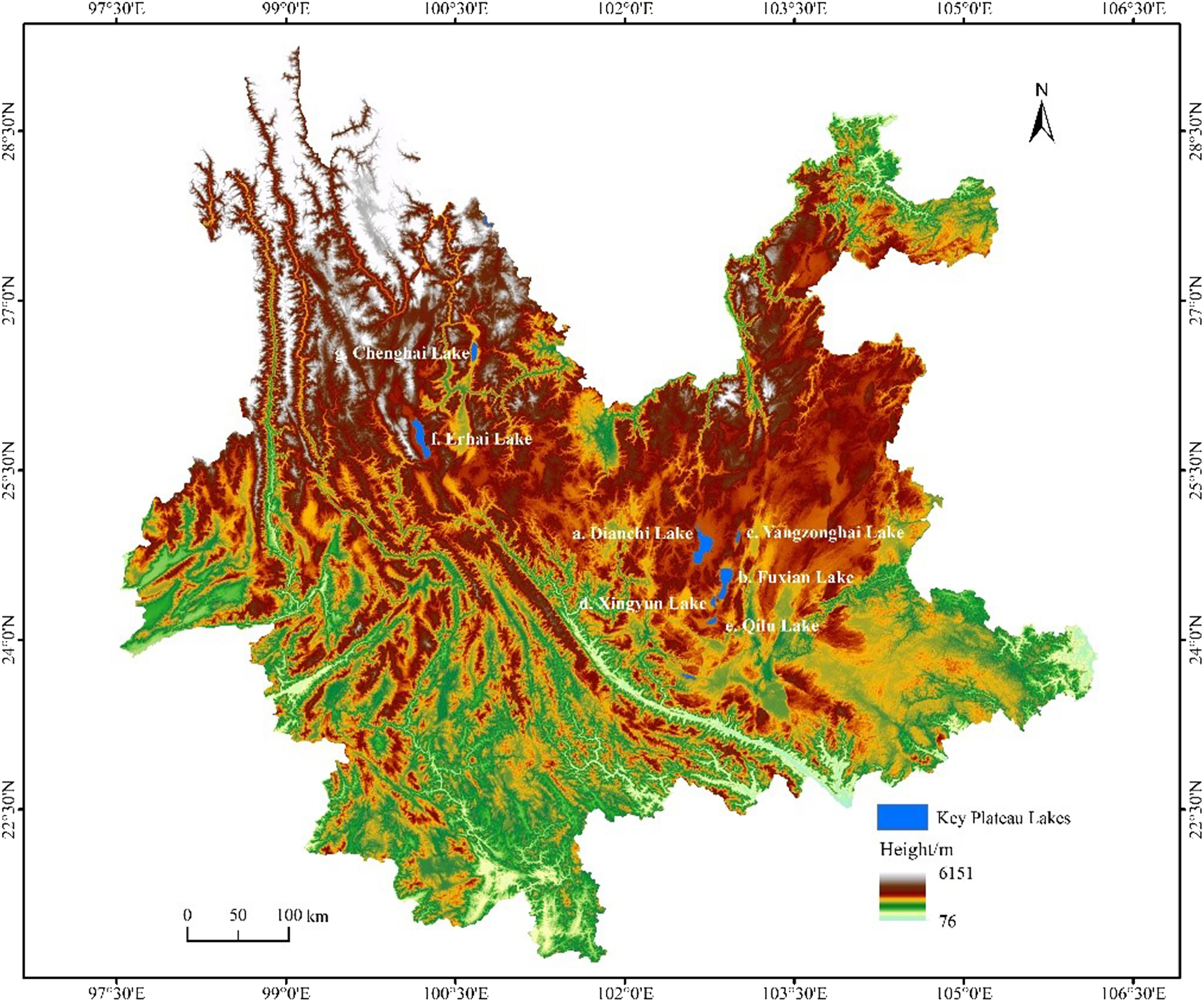
Location of the key plateau lakes in Yunnan province: a. Dianchi lake, b. Fuxian lake, c. Yangzonghai lake, d. Xingyun lake, e. Qilu lake, f. Erhai lake, g. Chenghai lake.
These key plateau lakes serve as ideal subjects for comparative analysis of shoreline extraction using multi-resolution remote sensing imagery, owing to their diverse morphologies and varying shoreline complexities. For example, the shorelines of Dianchi Lake and Yangzonghai Lake show significant urban expansion impacts, with a high proportion of artificial embankments that can be effectively identified using 10-m resolution imagery [23]. The west bank of Erhai Lake is adjacent to Cangshan Mountain, while the east bank is distributed with gentle farmland. The boundary between water and land cannot be effectively distinguished from low-resolution remote sensing images, due to the large number of artificial wetlands distributed along the lakeshore [24]. There are karst cliffs developed on the north bank of Fuxian Lake, with a high degree of tortuosity along the shoreline [25]. The Chenghai Lake Basin is narrow and elongated, with a significant difference in slope between the east and west bank. The smoothing effect of low-resolution data may affect the accuracy of shoreline length calculation [26].
3 Data and methods
3.1 Experiment data
The medium-resolution remote sensing images, including Landsat-8/9 OLI at 30 m, Sentinel-2 MSI at 10 m, and GF-1 WFV at 16 m, are obtained from United States Geological Survey (USGS), European Space Agency (ESA), and China Center for Resources Satellite Data and Application, respectively. Specifically, the Landsat-8 OLI multispectral sensor provides nine spectral bands with a spatial resolution of 30 m [27], 28]. The Sentinel-2 MSI covers almost all spectral bands ranging from 10 m to 20 m [29], while the GF-1 WFV includes four spectral bands at 16 m [30]. All remote sensing images were acquired in winter, and the downloaded data are Level 1A products.
3.2 Extraction of the shorelines of the key plateau lakes
All remote sensing images were converted to reflectance after radiometric calibration [31] and atmospheric correction [32]. Three water indices, NDWI, MNDWI, and AWEI, are then calculated by band math of specific bands of the remote sensing images. Due to the lack of the short-wave infrared bands in the GF-1 data, it is only feasible to extract the NDWI water index.
The calculation formula are as follows:
Note: All symbols in the formulas represent the reflectance of corresponding bands: GREEN = Reflectance of green band; NIR = Reflectance of near-infrared band; SWIR = Reflectance of short-wave infrared band; SWIR1 = Reflectance of short-wave infrared band 1; SWIR2 = Reflectance of short-wave infrared band 2.
Then, the lake shoreline can ultimately be extracted from the water index images by determining an appropriate threshold. After multiple validations, the threshold value used in this study is set to 0. The extracted lake shorelines underwent minor polygon removal and topological validation, ultimately yielding relatively complete shoreline data.
3.3 Accuracy assessment of the lake shorelines
The lake shorelines were accurately delineated through visual interpretation using 0.5-m resolution Jilin-1 imagery, serving as reference shorelines for accuracy assessment. Then, a 30-m buffer zone was established, using the reference shoreline as a baseline. Then, the number of intersecting pixels, and the length of the shoreline could be calculated by overlay analysis between the shoreline and the buffer zone [33]. The calculated pixel coincidence reflects the proximity between the extracted shoreline and the reference shoreline, with values closer to 1 indicating higher accuracy.
4 Results and discussion
4.1 Water index results of the plateau lakes in Yunnan province
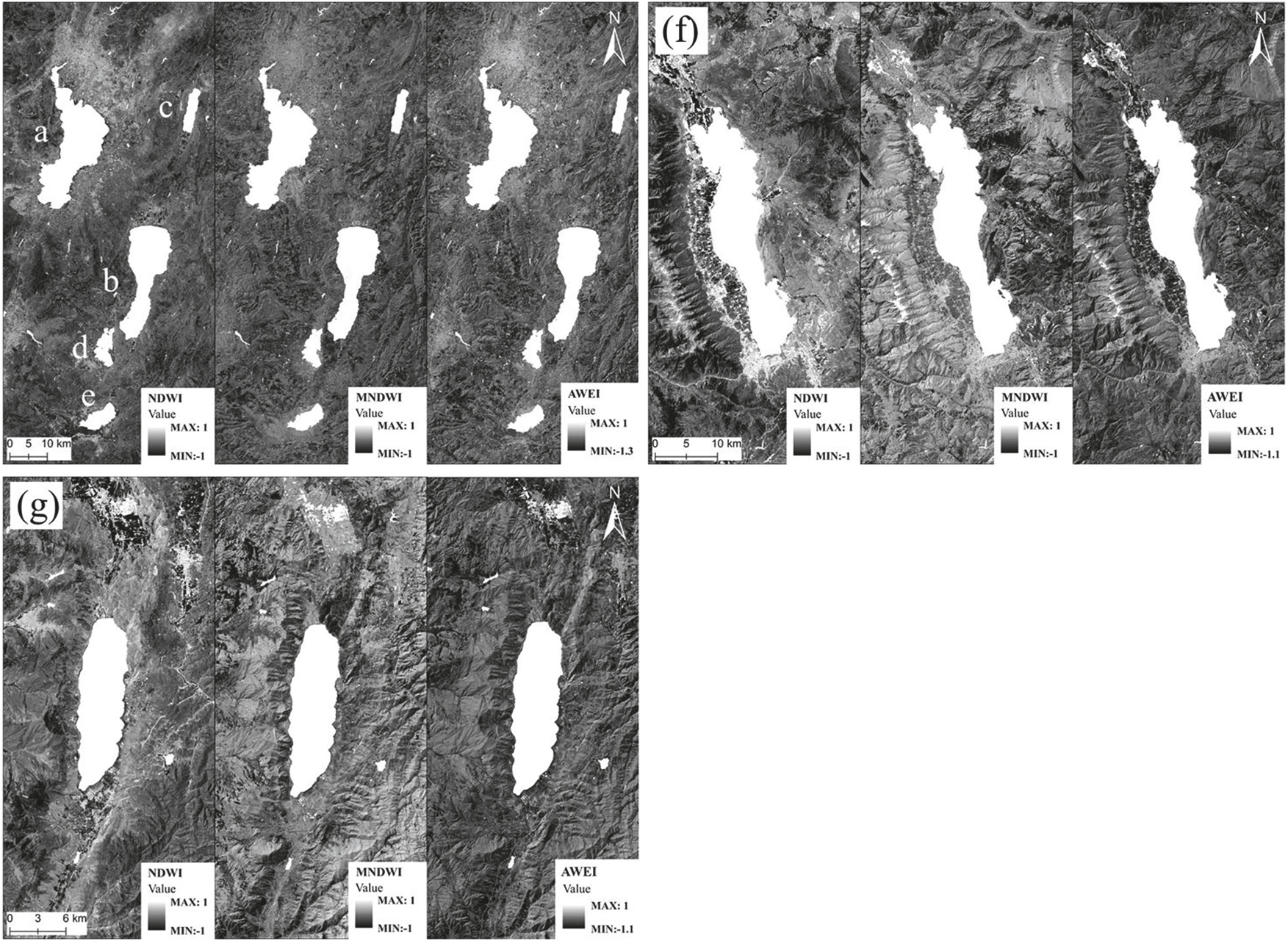
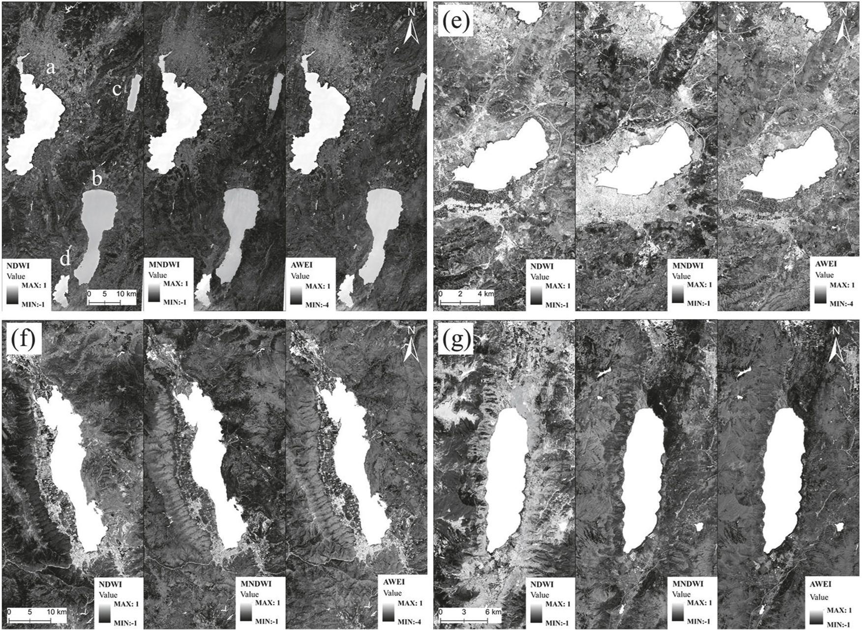
The water index results for NDWI, MNDWI, and AWEI of the key plateau lakes were obtained by Landsat 8–9 and Sentinel-2 images, respectively (Figures 2 and 3). All three water indices effectively identified water bodies and clearly distinguished water from non-water features, making the lake shorelines more evident (Figure 4).
Water index results of the key plateau lakes in Yunnan province from Landsat 8–9 images: a. Dianchi lake, b. Fuxian lake, c. Yangzonghai lake, d. Xingyun lake, e. Qilu lake, f. Erhai lake, g. Chenghai lake.
Water index results of the key plateau lakes in Yunnan province from Sentinel-2 images: a. Dianchi lake, b. Fuxian lake, c. Yangzonghai lake, d. Xingyun lake, e. Qilu lake, f. Erhai lake, g. Chenghai lake.
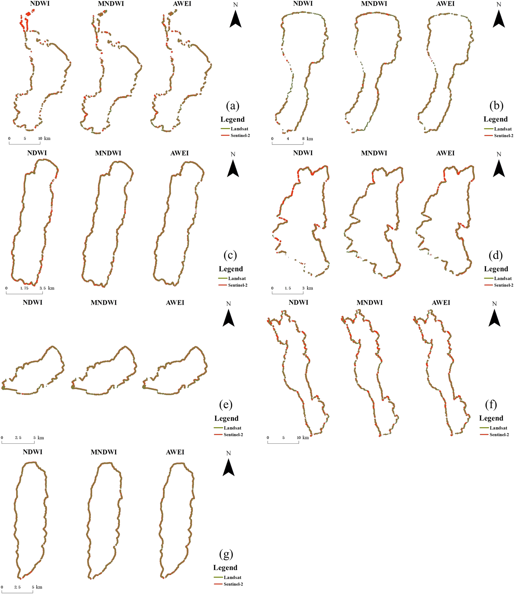
Overlay analysis between the extracted shoreline and the buffer zone of the reference shoreline: a. Dianchi lake, b. Fuxian lake, c. Yangzonghai lake, d. Xingyun lake, e. Qilu lake, f. Erhai lake, g. Chenghai lake.
AWEI demonstrated superior performance in complex environments by eliminating shadow interference, particularly in differentiating water from adjacent features. MNDWI reduced vegetation and soil interference, excelling in vegetated areas. Although the NDWI index exhibits high sensitivity to water bodies, it is prone to interference from soil and vegetation. As shown in Figures 2f–f, the water extraction accuracy of NDWI is significantly lower than that of AWEI and MNDWI in the densely vegetated southeastern region of Erhai Lake. Theoretically, MNDWI is preferable for vegetated lakes like Erhai Lake and Fuxian Lake, while AWEI suits urbanized lakes like Dianchi Lake to avoid shadow-induced errors.
Although the spatial resolution of Landsat 8–9 data is lower, it can still achieve a similar overall contour of water bodies to the higher-resolution Sentinel-2 data when the water area is large and the shape is relatively regular.
4.2 Lake shoreline analysis of the plateau lakes in Yunnan province
The shorelines of the key plateau lakes were extracted using Landsat 8–9 and Sentinel-2 images, and their accuracy was validated through overlay analysis with the buffer zone established based on reference shorelines.
Dianchi Lake is significantly affected by urban expansion, with a high proportion of artificial embankments. Due to its higher spatial resolution, Sentinel-2 images can clearly capture the details of artificial embankments, exhibiting strong coincidence with reference shoreline buffer zone. In contrast, Landsat images, with its coarser resolution, tends to misclassify wetlands and land, resulting in greater shoreline extraction deviations and lower coincidence.
The western bank of Erhai Lake borders the Cangshan Mountains, while the eastern bank consists of sloping farmland with high vegetation coverage. Sentinel-2 data demonstrate higher accuracy in identifying water-land boundaries in vegetated areas, though both datasets face challenges in the wetland regions. The AWEI index perform notably well in complex backgrounds, effectively reducing shadow interference and improving shoreline delineation accuracy.
The northern bank of Fuxian Lake features karst cliffs with highly irregular shoreline morphology. Sentinel-2 images, with its higher spatial resolution, effectively captures water boundaries within cliff shadows and accurately delineates the sinuous shoreline, showing a high coincidence with buffer zones. In contrast, Landsat data, limited by pixel-mixing effects, exhibits weaker performance in extracting intricate shoreline details, resulting in lower coincidence. Furthermore, the MNDWI index enhances shoreline extraction accuracy in vegetated areas by effectively suppressing vegetation noise.
Xingyun Lake has a regular shoreline and is predominantly surrounded by urban areas, resulting in a relatively homogeneous geographical environment. The shorelines extracted from both Landsat and Sentinel-2 data show high coincidence with the buffer zone of the reference shoreline, with Sentinel-2 exhibiting superior detail representation. All three water indices performed well, with MNDWI and AWEI effectively mitigating interference from vegetation and shadows, thereby improving extraction accuracy.
Qilu Lake is located in a stable geographical environment with minimal human disturbance. Sentinel-2 data provide higher shoreline extraction accuracy by capturing fine-scale morphological details. The AWEI index effectively removes shadow interference, while MNDWI reduces vegetation and soil noise, resulting in more realistic shoreline delineation.
Yangzonghai Lake is situated at the junction of Chenggong, Yiliang, and Chengjiang counties, with significant human activity impacts. Sentinel-2 data, due to its high resolution, accurately captures the detailed shoreline features of Yangzonghai Lake, showing high coincidence with the buffer zone, whereas Landsat data lacks such detail. For shadow processing, the AWEI index performs exceptionally well, while MNDWI is more effective in extracting shorelines within vegetation-covered areas.
Chenghai Lake exhibits an elongated basin morphology with distinct slope differences between its eastern and western banks. Sentinel-2 data accurately captures the intricate shoreline variations, yielding high-precision length calculations. In contrast, Landsat data introduces smoothing effects, resulting in significant shoreline length deviations and low coincidence. The MNDWI index performs optimally in vegetation-covered areas, while AWEI demonstrates superior robustness against topographic shadow interference in complex terrains.
The overlay analysis results demonstrate that the shorelines extracted from both Sentinel-2 and Landsat data can effectively capture the variations in lake boundaries. Among the three indices extracted, Sentinel-2 consistently demonstrated higher accuracy and detailed feature capture capability, benefiting from its higher spatial resolution. The subtle shoreline variations, including intricate curvatures and complex topographic features could be effectively identified by Sentinel-2 images. In contrast, Landsat, due to its coarser resolution, struggled to delineate fine-scale details in complex shorelines, resulting in minimal coincidence with the buffer zone of the reference shorelines.
The three water indices exhibit similar shoreline extraction accuracy in areas with less vegetation coverage, but MNDWI demonstrates better fitting performance in vegetated shoreline regions. When shorelines are highly irregular, the AWEI index demonstrates superior performance by effectively mitigating shadow interference and achieving higher coincidence with reference shorelines. However, shorelines extracted by all three indices exhibit significant gaps in shallow water areas. For instance, in the southern part of Erhai Lake, none of the indices perform well in delineating shorelines within shallow zones.
4.3 Accuracy assessment of the extracted lake shorelines
The accuracy assessment results of the extracted lake shorelines indicate that shorelines derived from Sentinel-2 data are generally more accurate than those from Landsat data, with results closer to the reference length. Sentinel-2 data not only confirmed the reliability of Landsat-8/9 in extracting large-scale lake contours but also compensated for Landsat’s limitations in capturing fine-scale shoreline details, verifying that high-resolution data can validate and improve the accuracy of medium-resolution data. For example, in the case of Dianchi Lake, the shoreline lengths extracted using the three water indices based on Sentinel-2 data have errors of around 30 km compared to the reference shoreline, with pixel coincidence rates of approximately 90 %, indicating relatively small errors. In contrast, the shoreline extracted from Landsat images is only about half of the actual length, failing to align with the true boundary. Therefore, the higher spatial resolution of Sentinel-2 images enables superior detail capture in complex environments or meandering shorelines, significantly improving extraction accuracy.
In terms of water indices, the AWEI index performs best with Sentinel-2 data, achieving higher accuracy. For instance, in Yangzonghai Lake, the shoreline length extracted using Sentinel-2 AWEI is 30.4 km, very close to the reference length of 32.1 km, with a pixel coincidence rate as high as 94.70 %. However, its performance is relatively lower with Landsat data, where the AWEI-extracted length is 27.5 km, with a pixel coincidence rate of only 85.68 %. The MNDWI index performs well with both Sentinel-2 and Landsat data, especially in Chenghai Lake, where the extracted shorelines have accuracies above 85 %, extremely close to the reference shoreline. Overall, the NDWI index exhibits the poorest extraction capability among the three indices. For example, the Sentinel-2 NDWI-extracted length of Erhai Lake is 85.4 km, with a pixel coincidence rate of only 71.94 %. However, its extraction accuracy is relatively closer to the reference length when using Landsat data.
Moreover, the morphology of lakes and their surrounding geographical environments significantly affect the shoreline extraction results. For example, Fuxian Lake and Xingyun Lake generally achieve higher extraction accuracy than Erhai Lake and Dianchi Lake, likely due to their more regular shoreline shapes and relatively stable, less complex surrounding environments. For instance, the Sentinel-2-extracted shoreline length of Fuxian Lake has a small error compared to the reference length and a high pixel coincidence rate. In contrast, Erhai Lake, with its complex surrounding vegetation cover, exhibits relatively lower extraction accuracy, with significant differences in pixel coincidence rates among different indices (Tables 1 and 2).
Accuracy assessment of the lake shoreline extracted from Landsat 8–9 images.
| Lake name | Pixel coincidence (%) | Length of the extracted shoreline (km) | Reference shoreline length (km) | ||||
|---|---|---|---|---|---|---|---|
| AWEI | MNDWI | NDWI | AWEI | MNDWI | NDWI | ||
| Dianchi lake | 44.56 % | 44.92 % | 36.88 % | 68.8 | 69.5 | 57.1 | 154.6 |
| Fuxian lake | 65.06 % | 64.25 % | 61.86 % | 58.2 | 57.5 | 55.4 | 89.5 |
| Yangzonghai lake | 85.68 % | 80.85 % | 69.56 % | 27.5 | 26.0 | 22.4 | 32.1 |
| Xingyun lake | 74.53 % | 36.20 % | 57.05 % | 26.8 | 13.0 | 20.5 | 35.9 |
| Qilu lake | 80.46 % | 80.51 % | 81.34 % | 31.7 | 31.7 | 32.0 | 39.4 |
| Erhai lake | 41.81 % | 49.74 % | 44.40 % | 49.6 | 57.5 | 51.4 | 118.7 |
| Chenghai lake | 83.18 % | 85.34 % | 83.66 % | 40.3 | 41.4 | 40.6 | 48.5 |
Accuracy assessment of the lake shoreline extracted from Sentinel-2 images.
| Lake name | Pixel coincidence (%) | Length of the extracted shoreline (km) | Reference shoreline length (km) | ||||
|---|---|---|---|---|---|---|---|
| AWEI | MNDWI | NDWI | AWEI | MNDWI | NDWI | ||
| Dianchi lake | 81.71 % | 79.06 % | 76.12 % | 126.3 | 122.3 | 117.7 | 154.6 |
| Fuxian lake | 81.15 % | 92.18 % | 65.05 % | 72.7 | 82.5 | 58.2 | 89.5 |
| Yangzonghai lake | 94.70 % | 94.41 % | 82.94 % | 30.4 | 30.3 | 26.7 | 32.1 |
| Xingyun lake | 90.09 % | 94.05 % | 84.40 % | 32.4 | 33.8 | 30.3 | 35.9 |
| Qilu lake | 91.61 % | 96.11 % | 86.49 % | 36.1 | 37.9 | 34.1 | 39.4 |
| Erhai lake | 84.46 % | 77.34 % | 71.94 % | 100.2 | 91.8 | 85.4 | 118.7 |
| Chenghai lake | 90.17 % | 92.88 % | 85.37 % | 43.8 | 45.1 | 41.4 | 48.5 |
5 Conclusions
Based on the comparative analysis of lake shoreline extraction accuracy using remote sensing data with different spatial resolutions and various water indices, this paper achieves the following conclusions:
The medium-resolution remote sensing data is suitable for rapid monitoring of the area change of large-scale lakes with regular shorelines and low vegetation coverage, but shows insufficient accuracy and blurred boundaries for complex shorelines or intricate terrain. Increasing the spatial resolution of remote sensing data can significantly improve the accuracy of lake shoreline extraction, particularly in areas with dense vegetation or complex shoreline topography.
Different remote sensing water indices demonstrate significant variations in applicability. NDWI is sensitive to water bodies but prone to vegetation interference, leading to lower accuracy in vegetated areas. MNDWI reduces vegetation and soil interference by incorporating the short-wave infrared band, improving shoreline extraction accuracy in vegetated zones. AWEI effectively suppresses shadow noise, demonstrating superior adaptability in complex environments and enhancing extraction accuracy in shaded areas.
The shoreline morphology and complex geographic settings of the key plateau lakes in Yunnan Province can significantly affect shoreline extraction accuracy. Therefore, it is essential to integrate multi-source remote sensing data with ground-based monitoring technologies to establish a multi-scale lake shoreline monitoring system. This integrated approach enables real-time and precise monitoring of lake dynamics, which is of great significance for ecological conservation and management of plateau lakes in Yunnan Province.
This study only used winter remote sensing data, which limits the analysis of seasonal and interannual variations in lake shorelines. Future research could integrate multi-seasonal and long-term datasets to clarify seasonal dynamics driven by monsoon precipitation and human activities.
Acknowledgments
Many thanks to the two anonymous reviewers for their insightful comments and suggestions. The authors also thank the United States Geological Survey (USGS), European Space Agency (ESA), and China Center for Resources Satellite Data and Application for providing the remote sensing data.
-
Funding information: Financial assistance was provided by the Natural Science Foundation of Yunnan Province (Grant no. 202101AS070019).
-
Author contribution: Conceptualization, Y.L.; methodology, Y.L.; data curation, J.Y.F; original draft preparation, J.Y.F; review and editing, Y.L.; funding acquisition, Y.L. All authors have accepted responsibility for the entire content of this manuscript and approved its submission.
-
Conflicts of interest: The authors state no conflicts of interest.
-
Data availability statement: All data generated or analysed during this study are included in this published article.
References
1. Adrian, R, O’Reilly, CM, Zagarese, H, Baines, SB, Hessen, DO, Keller, W, et al.. Lakes as sentinels of climate change. Limnol Oceanogr 2009;54:2283–97. https://doi.org/10.4319/lo.2009.54.6_part_2.2283.Search in Google Scholar
2. Tan, G, Yao, S, Li, L. Key technical problems and expected achievements in efficient use and protection of the resources of river and lake shoreline and inland river marshland. Adv Eng Sci 2019;51:1–8.Search in Google Scholar
3. Du, Y, Zhou, C. Automatically extracting remote sensing information for water bodies. J Remote Sens 1998;2:264–9.Search in Google Scholar
4. Guirguis, SK, Raey, MEE, Hussain, M, Hassan, HM. Technical note multi-temporal change of lake Brullus, Egypt, from 1983 to 1991. Int J Remote Sens 1996;17:2915–21. https://doi.org/10.1080/01431169608949118.Search in Google Scholar
5. Göksel, Ç, Akyüz, D, Kabdaşlı, M, Balcik, F, Seker, D. Definition of sensitive areas in a lakeshore by using remote sensing and GIS. Fresenius Environ Bull 2004;13:860–4.Search in Google Scholar
6. Yang, Y, Zhang, G, Hong, C, Yan, P, Ha, S, Dong, M, et al.. Lake area variations in the Altun mountain national nature reserve 1970-2021. J Beijing Normal Univ Nat Sci 2024;60:541–50.Search in Google Scholar
7. Liu, J, Tian, B, Wu, C, Ding, Y, Gao, P, Mu, X. Analysis of lake area changes and driving factors in Nam Co and Selin Co from 1976 to 2021. J Salt Lake Res 2024;32:61–8. https://doi.org/10.3724/j.yhyj.2024013.Search in Google Scholar
8. Han, S, Wang, L. A Survey of thresholding methods for image segmentation. Syst Eng Electron 2002;24:91–4.Search in Google Scholar
9. Chen, W, Jing, J, Li, Y, Niu, Z. Extraction of water information based on China-made GF-1 remote sense image. Resour Sci 2015;37:1166–72.Search in Google Scholar
10. Li, D, Wu, B, Chen, B, Xue, Y, Zhang, Y. Review of water body information extraction based on satellite remote sensing. J Tsinghua Univ Sci Technol 2020;60:147–61.Search in Google Scholar
11. Xiong, J, Wang, S, Zhou, Y. A sensitivity analysis and accuracy assessment of different water extraction index models based on ALOS AVNIR - 2 data. Remote Sens Land Resour 2010;22:46–50.Search in Google Scholar
12. Barton, IJ, Bathols, JM. Monitoring floods with AVHRR. Remote Sens Environ 1989;30:89–94. https://doi.org/10.1016/0034-4257(89)90050-3.Search in Google Scholar
13. Sun, Z, Zhao, Y, Chen, J, Li, G, Tan, M. Application of object-oriented classification in extraction of impervious degree of urban surface. Sci Geogr Sin 2007;27:837–42.Search in Google Scholar
14. McFeeters, SK. The use of the normalized difference water index (NDWI) in the delineation of open water features. Int J Remote Sens 1996;17:1425–32. https://doi.org/10.1080/01431169608948714.Search in Google Scholar
15. Xu, H. A study on information extraction of water body with the modified normalized difference water index (MNDWI). J Remote Sens 2005;9:589–95. https://doi.org/10.11834/jrs.20050586.Search in Google Scholar
16. Feyisa, GL, Meilby, H, Fensholt, R, Proud, SR. Automated water extraction index: a new technique for surface water mapping using Landsat imagery. Remote Sens Environ 2014;140:23–35. https://doi.org/10.1016/j.rse.2013.08.029.Search in Google Scholar
17. Liu, S, Huang, D, Wang, J, Yu, Z. Monitoring surface moisture changes using NDWI and extended indices: a case study of Suyahu reservoir. Hydro-Sci Eng 2024:103–14.Search in Google Scholar
18. Liu, S, Wu, Y, Zhang, G, Lin, N, Liu, Z. Comparing water indices for Landsat data for automated surface water body extraction under complex ground background: a case study in Jilin province. Remote Sens 2023;15:1678. https://doi.org/10.3390/rs15061678.Search in Google Scholar
19. Bai, K, Li, Z, Zhang, P, Wang, Z, Zhao, W, Lu, H. Shoreline evolution of natural lakes in lake Dongting area based on multi-source remote sensing interpretation. J Lake Sci 2024;36:1537–49. https://doi.org/10.18307/2024.0543.Search in Google Scholar
20. Yu, Y, Zhang, M, Qian, S, Li, D, Kong, F. Current status and development of water quality of lakes in Yunnan-Guizhou plateau. J Lake Sci 2010;22:820–8.Search in Google Scholar
21. Li, Q, Wang, Y, Li, L, Zhang, H, Wang, B. Ecological restoration scheme of lake basins on the karst plateau based on natural solution: take nine lakes on the Yunnan plateau as example. Carsol Sin/Zhong Guo Yan Rong 2023;42:391–401.Search in Google Scholar
22. Li, S, Yu, M, Li, G, Ceng, J, Chen, J, Gao, B, et al.. Limnological survey of the lakes of Yunnan plateau. Oceanol Limnol Sin 1963;02:87–114.Search in Google Scholar
23. Cundill, SL, Meijde, Mvd, Hack, HRGK. Investigation of remote sensing for potential use in dike inspection. IEEE J Sel Top Appl Earth Obs Rem Sens 2014;7:733–46. https://doi.org/10.1109/jstars.2013.2293617.Search in Google Scholar
24. Zhai, Y. Study on pollution of inflow rivers in the lake Erhai watershed and constructed wetland technology. Shanghai: Shanghai Jiao Tong University; 2012.Search in Google Scholar
25. Li, S, Zhou, J, Wang, J. Spatio-temporal LUCC and driving force in Fuxian lake watershed from 1974 to 2014. Remote Sens Nat Resour 2017;29:132–9.Search in Google Scholar
26. Obata, K, Wada, T, Miura, T, Yoshioka, H. Scaling effect of area-averaged NDVI: monotonicity along the spatial resolution. Remote Sens 2012;4:160–79. https://doi.org/10.3390/rs4010160.Search in Google Scholar
27. Trevisiol, F, Mandanici, E, Pagliarani, A, Bitelli, G. Evaluation of Landsat-9 interoperability with Sentinel-2 and Landsat-8 over Europe and local comparison with field surveys. ISPRS J Photogramm Remote Sens 2024;210:55–68. https://doi.org/10.1016/j.isprsjprs.2024.02.021.Search in Google Scholar
28. González-Márquez, LC, Torres-Bejarano, FM, Torregroza-Espinosa, AC, Hansen-Rodríguez, IR, Rodríguez-Gallegos, HB. Use of LANDSAT 8 images for depth and water quality assessment of El Guájaro reservoir, Colombia. J South Am Earth Sci 2018;82:231–8. https://doi.org/10.1016/j.jsames.2018.01.004.Search in Google Scholar
29. Sambandham, VT, Kirchheim, K, Ortmeier, F, Mukhopadhaya, S. Deep learning-based harmonization and super-resolution of Landsat-8 and Sentinel-2 images. ISPRS J Photogramm Remote Sens 2024;212:274–88. https://doi.org/10.1016/j.isprsjprs.2024.04.026.Search in Google Scholar
30. Sun, N, Zhu, W, Cheng, Q. GF-1 and Landsat observed a 40-year wetland spatiotemporal variation and its coupled environmental factors in Yangtze river estuary. Estuarine Coastal Shelf Sci 2018;207:30–9. https://doi.org/10.1016/j.ecss.2018.03.022.Search in Google Scholar
31. Guo, Y, Senthilnath, J, Wu, W, Zhang, X, Zeng, Z, Huang, H. Radiometric calibration for multispectral camera of different imaging conditions mounted on a UAV platform. Sustainability 2019;11:978. https://doi.org/10.3390/su11040978.Search in Google Scholar
32. Sola, I, García-Martín, A, Sandonís-Pozo, L, Álvarez-Mozos, J, Pérez-Cabello, F, González-Audícana, M, et al.. Assessment of atmospheric correction methods for Sentinel-2 images in mediterranean landscapes. Int J Appl Earth Obs Geoinf 2018;73:63–76. https://doi.org/10.1016/j.jag.2018.05.020.Search in Google Scholar
33. Congalton, RG, Green, K. Assessing the accuracy of remotely sensed data: principles and practices. Boca Raton, Florida: CRC Press; 2009.Search in Google Scholar
© 2025 the author(s), published by De Gruyter, Berlin/Boston
This work is licensed under the Creative Commons Attribution 4.0 International License.
Articles in the same Issue
- Research Articles
- Single-step fabrication of Ag2S/poly-2-mercaptoaniline nanoribbon photocathodes for green hydrogen generation from artificial and natural red-sea water
- Abundant new interaction solutions and nonlinear dynamics for the (3+1)-dimensional Hirota–Satsuma–Ito-like equation
- A novel gold and SiO2 material based planar 5-element high HPBW end-fire antenna array for 300 GHz applications
- Explicit exact solutions and bifurcation analysis for the mZK equation with truncated M-fractional derivatives utilizing two reliable methods
- Optical and laser damage resistance: Role of periodic cylindrical surfaces
- Numerical study of flow and heat transfer in the air-side metal foam partially filled channels of panel-type radiator under forced convection
- Water-based hybrid nanofluid flow containing CNT nanoparticles over an extending surface with velocity slips, thermal convective, and zero-mass flux conditions
- Dynamical wave structures for some diffusion--reaction equations with quadratic and quartic nonlinearities
- Solving an isotropic grey matter tumour model via a heat transfer equation
- Study on the penetration protection of a fiber-reinforced composite structure with CNTs/GFP clip STF/3DKevlar
- Influence of Hall current and acoustic pressure on nanostructured DPL thermoelastic plates under ramp heating in a double-temperature model
- Applications of the Belousov–Zhabotinsky reaction–diffusion system: Analytical and numerical approaches
- AC electroosmotic flow of Maxwell fluid in a pH-regulated parallel-plate silica nanochannel
- Interpreting optical effects with relativistic transformations adopting one-way synchronization to conserve simultaneity and space–time continuity
- Modeling and analysis of quantum communication channel in airborne platforms with boundary layer effects
- Theoretical and numerical investigation of a memristor system with a piecewise memductance under fractal–fractional derivatives
- Tuning the structure and electro-optical properties of α-Cr2O3 films by heat treatment/La doping for optoelectronic applications
- High-speed multi-spectral explosion temperature measurement using golden-section accelerated Pearson correlation algorithm
- Dynamic behavior and modulation instability of the generalized coupled fractional nonlinear Helmholtz equation with cubic–quintic term
- Study on the duration of laser-induced air plasma flash near thin film surface
- Exploring the dynamics of fractional-order nonlinear dispersive wave system through homotopy technique
- The mechanism of carbon monoxide fluorescence inside a femtosecond laser-induced plasma
- Numerical solution of a nonconstant coefficient advection diffusion equation in an irregular domain and analyses of numerical dispersion and dissipation
- Numerical examination of the chemically reactive MHD flow of hybrid nanofluids over a two-dimensional stretching surface with the Cattaneo–Christov model and slip conditions
- Impacts of sinusoidal heat flux and embraced heated rectangular cavity on natural convection within a square enclosure partially filled with porous medium and Casson-hybrid nanofluid
- Stability analysis of unsteady ternary nanofluid flow past a stretching/shrinking wedge
- Solitonic wave solutions of a Hamiltonian nonlinear atom chain model through the Hirota bilinear transformation method
- Bilinear form and soltion solutions for (3+1)-dimensional negative-order KdV-CBS equation
- Solitary chirp pulses and soliton control for variable coefficients cubic–quintic nonlinear Schrödinger equation in nonuniform management system
- Influence of decaying heat source and temperature-dependent thermal conductivity on photo-hydro-elasto semiconductor media
- Dissipative disorder optimization in the radiative thin film flow of partially ionized non-Newtonian hybrid nanofluid with second-order slip condition
- Bifurcation, chaotic behavior, and traveling wave solutions for the fractional (4+1)-dimensional Davey–Stewartson–Kadomtsev–Petviashvili model
- New investigation on soliton solutions of two nonlinear PDEs in mathematical physics with a dynamical property: Bifurcation analysis
- Mathematical analysis of nanoparticle type and volume fraction on heat transfer efficiency of nanofluids
- Creation of single-wing Lorenz-like attractors via a ten-ninths-degree term
- Optical soliton solutions, bifurcation analysis, chaotic behaviors of nonlinear Schrödinger equation and modulation instability in optical fiber
- Chaotic dynamics and some solutions for the (n + 1)-dimensional modified Zakharov–Kuznetsov equation in plasma physics
- Fractal formation and chaotic soliton phenomena in nonlinear conformable Heisenberg ferromagnetic spin chain equation
- Single-step fabrication of Mn(iv) oxide-Mn(ii) sulfide/poly-2-mercaptoaniline porous network nanocomposite for pseudo-supercapacitors and charge storage
- Novel constructed dynamical analytical solutions and conserved quantities of the new (2+1)-dimensional KdV model describing acoustic wave propagation
- Tavis–Cummings model in the presence of a deformed field and time-dependent coupling
- Spinning dynamics of stress-dependent viscosity of generalized Cross-nonlinear materials affected by gravitationally swirling disk
- Design and prediction of high optical density photovoltaic polymers using machine learning-DFT studies
- Robust control and preservation of quantum steering, nonlocality, and coherence in open atomic systems
- Coating thickness and process efficiency of reverse roll coating using a magnetized hybrid nanomaterial flow
- Dynamic analysis, circuit realization, and its synchronization of a new chaotic hyperjerk system
- Decoherence of steerability and coherence dynamics induced by nonlinear qubit–cavity interactions
- Finite element analysis of turbulent thermal enhancement in grooved channels with flat- and plus-shaped fins
- Modulational instability and associated ion-acoustic modulated envelope solitons in a quantum plasma having ion beams
- Statistical inference of constant-stress partially accelerated life tests under type II generalized hybrid censored data from Burr III distribution
- On solutions of the Dirac equation for 1D hydrogenic atoms or ions
- Entropy optimization for chemically reactive magnetized unsteady thin film hybrid nanofluid flow on inclined surface subject to nonlinear mixed convection and variable temperature
- Stability analysis, circuit simulation, and color image encryption of a novel four-dimensional hyperchaotic model with hidden and self-excited attractors
- A high-accuracy exponential time integration scheme for the Darcy–Forchheimer Williamson fluid flow with temperature-dependent conductivity
- Novel analysis of fractional regularized long-wave equation in plasma dynamics
- Development of a photoelectrode based on a bismuth(iii) oxyiodide/intercalated iodide-poly(1H-pyrrole) rough spherical nanocomposite for green hydrogen generation
- Investigation of solar radiation effects on the energy performance of the (Al2O3–CuO–Cu)/H2O ternary nanofluidic system through a convectively heated cylinder
- Quantum resources for a system of two atoms interacting with a deformed field in the presence of intensity-dependent coupling
- Studying bifurcations and chaotic dynamics in the generalized hyperelastic-rod wave equation through Hamiltonian mechanics
- A new numerical technique for the solution of time-fractional nonlinear Klein–Gordon equation involving Atangana–Baleanu derivative using cubic B-spline functions
- Interaction solutions of high-order breathers and lumps for a (3+1)-dimensional conformable fractional potential-YTSF-like model
- Hydraulic fracturing radioactive source tracing technology based on hydraulic fracturing tracing mechanics model
- Numerical solution and stability analysis of non-Newtonian hybrid nanofluid flow subject to exponential heat source/sink over a Riga sheet
- Numerical investigation of mixed convection and viscous dissipation in couple stress nanofluid flow: A merged Adomian decomposition method and Mohand transform
- Effectual quintic B-spline functions for solving the time fractional coupled Boussinesq–Burgers equation arising in shallow water waves
- Analysis of MHD hybrid nanofluid flow over cone and wedge with exponential and thermal heat source and activation energy
- Solitons and travelling waves structure for M-fractional Kairat-II equation using three explicit methods
- Impact of nanoparticle shapes on the heat transfer properties of Cu and CuO nanofluids flowing over a stretching surface with slip effects: A computational study
- Computational simulation of heat transfer and nanofluid flow for two-sided lid-driven square cavity under the influence of magnetic field
- Irreversibility analysis of a bioconvective two-phase nanofluid in a Maxwell (non-Newtonian) flow induced by a rotating disk with thermal radiation
- Hydrodynamic and sensitivity analysis of a polymeric calendering process for non-Newtonian fluids with temperature-dependent viscosity
- Exploring the peakon solitons molecules and solitary wave structure to the nonlinear damped Kortewege–de Vries equation through efficient technique
- Modeling and heat transfer analysis of magnetized hybrid micropolar blood-based nanofluid flow in Darcy–Forchheimer porous stenosis narrow arteries
- Activation energy and cross-diffusion effects on 3D rotating nanofluid flow in a Darcy–Forchheimer porous medium with radiation and convective heating
- Insights into chemical reactions occurring in generalized nanomaterials due to spinning surface with melting constraints
- Influence of a magnetic field on double-porosity photo-thermoelastic materials under Lord–Shulman theory
- Soliton-like solutions for a nonlinear doubly dispersive equation in an elastic Murnaghan's rod via Hirota's bilinear method
- Analytical and numerical investigation of exact wave patterns and chaotic dynamics in the extended improved Boussinesq equation
- Nonclassical correlation dynamics of Heisenberg XYZ states with (x, y)-spin--orbit interaction, x-magnetic field, and intrinsic decoherence effects
- Exact traveling wave and soliton solutions for chemotaxis model and (3+1)-dimensional Boiti–Leon–Manna–Pempinelli equation
- Unveiling the transformative role of samarium in ZnO: Exploring structural and optical modifications for advanced functional applications
- On the derivation of solitary wave solutions for the time-fractional Rosenau equation through two analytical techniques
- Analyzing the role of length and radius of MWCNTs in a nanofluid flow influenced by variable thermal conductivity and viscosity considering Marangoni convection
- Advanced mathematical analysis of heat and mass transfer in oscillatory micropolar bio-nanofluid flows via peristaltic waves and electroosmotic effects
- Exact bound state solutions of the radial Schrödinger equation for the Coulomb potential by conformable Nikiforov–Uvarov approach
- Some anisotropic and perfect fluid plane symmetric solutions of Einstein's field equations using killing symmetries
- Nonlinear dynamics of the dissipative ion-acoustic solitary waves in anisotropic rotating magnetoplasmas
- Curves in multiplicative equiaffine plane
- Exact solution of the three-dimensional (3D) Z2 lattice gauge theory
- Propagation properties of Airyprime pulses in relaxing nonlinear media
- Symbolic computation: Analytical solutions and dynamics of a shallow water wave equation in coastal engineering
- Wave propagation in nonlocal piezo-photo-hygrothermoelastic semiconductors subjected to heat and moisture flux
- Comparative reaction dynamics in rotating nanofluid systems: Quartic and cubic kinetics under MHD influence
- Laplace transform technique and probabilistic analysis-based hypothesis testing in medical and engineering applications
- Physical properties of ternary chloro-perovskites KTCl3 (T = Ge, Al) for optoelectronic applications
- Gravitational length stretching: Curvature-induced modulation of quantum probability densities
- The search for the cosmological cold dark matter axion – A new refined narrow mass window and detection scheme
- A comparative study of quantum resources in bipartite Lipkin–Meshkov–Glick model under DM interaction and Zeeman splitting
- PbO-doped K2O–BaO–Al2O3–B2O3–TeO2-glasses: Mechanical and shielding efficacy
- Nanospherical arsenic(iii) oxoiodide/iodide-intercalated poly(N-methylpyrrole) composite synthesis for broad-spectrum optical detection
- Sine power Burr X distribution with estimation and applications in physics and other fields
- Numerical modeling of enhanced reactive oxygen plasma in pulsed laser deposition of metal oxide thin films
- Dynamical analyses and dispersive soliton solutions to the nonlinear fractional model in stratified fluids
- Computation of exact analytical soliton solutions and their dynamics in advanced optical system
- An innovative approximation concerning the diffusion and electrical conductivity tensor at critical altitudes within the F-region of ionospheric plasma at low latitudes
- An analytical investigation to the (3+1)-dimensional Yu–Toda–Sassa–Fukuyama equation with dynamical analysis: Bifurcation
- Swirling-annular-flow-induced instability of a micro shell considering Knudsen number and viscosity effects
- Numerical analysis of non-similar convection flows of a two-phase nanofluid past a semi-infinite vertical plate with thermal radiation
- MgO NPs reinforced PCL/PVC nanocomposite films with enhanced UV shielding and thermal stability for packaging applications
- Optimal conditions for indoor air purification using non-thermal Corona discharge electrostatic precipitator
- Investigation of thermal conductivity and Raman spectra for HfAlB, TaAlB, and WAlB based on first-principles calculations
- Tunable double plasmon-induced transparency based on monolayer patterned graphene metamaterial
- DSC: depth data quality optimization framework for RGBD camouflaged object detection
- A new family of Poisson-exponential distributions with applications to cancer data and glass fiber reliability
- Numerical investigation of couple stress under slip conditions via modified Adomian decomposition method
- Monitoring plateau lake area changes in Yunnan province, southwestern China using medium-resolution remote sensing imagery: applicability of water indices and environmental dependencies
- Heterodyne interferometric fiber-optic gyroscope
- Exact solutions of Einstein’s field equations via homothetic symmetries of non-static plane symmetric spacetime
- A widespread study of discrete entropic model and its distribution along with fluctuations of energy
- Empirical model integration for accurate charge carrier mobility simulation in silicon MOSFETs
- The influence of scattering correction effect based on optical path distribution on CO2 retrieval
- Anisotropic dissociation and spectral response of 1-Bromo-4-chlorobenzene under static directional electric fields
- Role of tungsten oxide (WO3) on thermal and optical properties of smart polymer composites
- Analysis of iterative deblurring: no explicit noise
- The influence of anisotropy of InP on its elasticity and phonon properties
- Review Article
- Examination of the gamma radiation shielding properties of different clay and sand materials in the Adrar region
- Erratum
- Erratum to “On Soliton structures in optical fiber communications with Kundu–Mukherjee–Naskar model (Open Physics 2021;19:679–682)”
- Special Issue on Fundamental Physics from Atoms to Cosmos - Part II
- Possible explanation for the neutron lifetime puzzle
- Special Issue on Nanomaterial utilization and structural optimization - Part III
- Numerical investigation on fluid-thermal-electric performance of a thermoelectric-integrated helically coiled tube heat exchanger for coal mine air cooling
- Special Issue on Nonlinear Dynamics and Chaos in Physical Systems
- Analysis of the fractional relativistic isothermal gas sphere with application to neutron stars
- Abundant wave symmetries in the (3+1)-dimensional Chafee–Infante equation through the Hirota bilinear transformation technique
- Successive midpoint method for fractional differential equations with nonlocal kernels: Error analysis, stability, and applications
- Novel exact solitons to the fractional modified mixed-Korteweg--de Vries model with a stability analysis