Visualizing sustainable rainwater harvesting: A case study of Karbala Province
-
 ,
,

Abstract
The management of rainwater collection in a practical way is a fundamental need for the management of water resources in a manner that is sustainable. The goal of this research is to determine whether or not remote sensing technology is effective in providing data on precipitation for the purpose of locating rainwater collection tank locations in the province of Karbala. Rainfall patterns fluctuate considerably. Remote sensing may not capture variability enough to estimate the rainfall period and location. Sustainable rainfall harvesting requires accurate rainfall timing and distribution. This information is applied in the modeling of hydrological processes, the management of disasters, and environmental research. Following the completion of a geographical study, it has been established that the city of Karbala may be divided into two basic sections. Through the use of estimation, it is possible to more easily identify the region that is ideal for the location of rainwater-harvesting reservoirs and lakes. On the contrary, it is crucial to keep in mind that a location that was chosen based on average rainfall over a period of two years could not be suitable for other time periods. This is an idea that should be kept in mind several times. To put this into perspective, when choosing a location, it is vital to take into consideration the severity of the rainfall as well as the geographical location of the area. Particularly in locations such as Karbala, the implementation of data visualization systems into water management practices has the potential to improve both the efficiency and sustainability of water management methods. The findings of this study show the significance of implementing precise site selection techniques to enhance rainwater collection systems and encourage activities that are environmentally responsible for water management.
1 Introduction
Recently, the sustainable rainwater collection area has seen notable progress due to the increasing acknowledgment of the significance of data-driven decision-making in enhancing rainwater harvesting (RWH) systems for long-term sustainability and socioeconomic advantages [1,2,3].
Data visualization in RWH systems is a crucial tool that provides simple and understandable representations to help understand complicated data patterns and support informed decision-making processes [4,5,6,7,8]. Stakeholders, including politicians, engineers, and community members, can analyze rainfall patterns, water storage capacities, water quality parameters, and system performance more clearly and precisely using visual representations like charts, graphs, and maps. This improved comprehension encourages cooperation in building and maintaining sustainable RWH systems, which enhances the efficient use of water resources [9,10]. This promotes joint efforts to construct and manage sustainable harvesting systems for rainwater.
Graphing data is crucial for the advancement of rainwater collection technology [5,11]. Visual representations of rainfall data help decision-makers identify patterns and trends, allowing them to make precise and timely decisions on RWH techniques and timing. Real-time monitoring and modeling improve water management efficiency by reducing hazards related to water surplus and maximizing the use of resources [7,12].
Information visualization can improve community involvement and understanding of sustainable rainwater gathering systems. Providing communities with easily understandable and significant data enables them to take an active role in overseeing their water resources. This promotes a feeling of ownership and accountability in activities such as rainwater collection, water conservation, and achieving sustainable objectives in the long run [8,13].
This research intends to enhance the field of data visualization in sustainable RWH by offering a case study on the Karbala province. We aim to use data visualization, remote sensing technologies, and geographical analysis to find the best locations for RWH equipment. This will improve water resource management in the area. Our research seeks to fill current gaps in the field and offer insights to guide decision-making for promoting sustainable water management methods in Karbala and other areas.
Remote sensing uses satellite or aerial photos to measure rainfall. This data’s accuracy and resolution can vary, affecting regional precipitation predictions. Accurate sustainable rainfall harvesting (SRWH) system construction and operation require high-resolution data.
2 Literature review
In this century, sustainable RWH has gained popularity as an instrument to tackle water scarcity and boost environmental sustainability [7,13–16]. Visualizing data becomes essential for improving decision-making and controlling RWH systems since there is a growing desire for environmentally friendly water resource management [17,18]. This literature review discusses data visualization in sustainable RWH, covering its advantages and disadvantages [12,19].
2.1 RWH and sustainability
The methodology of RWH has been widely employed for an extended period of time. It includes harvesting and storing rainwater for numerous purposes, including irrigation, residential consumption, and resupplying groundwater resources [8,15,20]. The strategy mentioned previously is considered sustainable since it has the ability to reduce reliance on traditional water sources, prevent runoff, and reduce the effects of crises and shortages of water [5,21,22].
2.2 RWH visualization in scientific research
The Environmental Systems Research Institute (Esri ArcGIS) is essential for remote precipitation analysis and visualization. Researchers in meteorology, hydrology, environmental science, and related domains need this technology. For research, strategic planning, and informed decision-making, these people demand precise and up-to-date rainfall data. With academic integrity, the developers may investigate ArcGIS’s comprehensive and sophisticated functions in remote precipitation data analysis [17,18,23–27].
A number of those assessed throughout the research project took advantage of the opportunity to investigate rainfall data through the application of diverse remote sensing technologies. Table 1 provides a detailed review of the studies, effectively highlighting their primary outcomes and corresponding recommendations [6,7,10,23–37]. Taking advantage of data visualization has a major significance in the framework of sustainable water harvesting, as it serves to offer significant insights, facilitate informed decision-making processes, and foster efficient communication among various parties involved. There are several significant ways in which data visualization integrates with the sustainability of RWH [1,28].
| Authors | Main findings | Outcomes measured |
|---|---|---|
| Ya’acob et al. [23] |
|
|
|
|
|
|
||
| Sayl et al. [25] |
|
|
|
|
|
|
|
|
| Karani et al. [31] |
|
|
|
||
|
||
| Baby et al. [27] |
|
|
|
|
|
|
|
|
|
||
| Choudhary et al. [34] |
|
|
|
|
|
|
|
|
|
||
| Tiwari et al. [24] |
|
|
|
|
|
|
||
| Hari et al. [32] |
|
|
|
|
|
|
|
|
|
||
| Ahmad [36] |
|
|
|
||
|
||
| Chiu et al. [35] |
|
|
|
|
|
|
|
|
| Gaikwad [33] |
|
|
|
|
|
|
|
|
|
||
| Sayl et al. [25] |
|
|
|
|
|
|
|
|
| He et al. [38] |
|
|
2.3 Utilizing data visualization for sustainable RWH in Karbala
The practice of sustainable RWH has gained significant traction in recent years as a crucial solution to address water scarcity and enhance environmental sustainability [7,13–15]. In tandem with this trend, the importance of data visualization has emerged as a critical component in optimizing decision-making processes and controlling RWH systems, driven by the increasing demand for environmentally friendly water resource management [12]. While existing literature discusses the role of data visualization in sustainable RWH, this study aims to contribute to the field by addressing key gaps and presenting novel methodologies tailored to the context of Karbala province. Specifically, we highlight the distinctive features of our research compared to prior studies in the following ways:
Focused application in Karbala province: Previous studies have provided insights into RWH practices and visualization techniques in various regions. However, our study specifically targets Karbala province, recognizing the unique geographic and climatic characteristics of the area. By narrowing our focus, we aim to provide contextually relevant solutions that cater to the specific needs and challenges of Karbala.
Integration of remote sensing and Geographic Information Systems (GIS): While remote sensing and GIS technologies have been utilized in prior research to assess RWH potential, our study seeks to advance this integration further. We employ sophisticated methodologies to analyze remote precipitation data and visualize rainfall patterns with greater precision and detail. By leveraging these advanced technologies, we aim to enhance the accuracy and effectiveness of RWH site selection in Karbala.
Emphasis on data visualization: While previous studies acknowledge the importance of data visualization, our research places a stronger emphasis on this aspect. We not only visualize rainfall data but also analyze its implications for RWH system design and management. Through comprehensive visualizations, decision-makers can gain valuable insights into rainfall patterns and make informed choices regarding site selection and system optimization.
Quantitative assessment of rainfall patterns: In contrast to some prior studies that primarily focus on qualitative assessments, our research includes quantitative analysis of rainfall patterns spanning a 19-year timeframe. By providing specific and quantitative results, we offer a deeper understanding of the variability and intensity of rainfall in Karbala, enabling more precise decision-making in RWH system planning and implementation.
This study attempts to address gaps in the literature by providing a thorough and contextually appropriate investigation of RWH practices in the Karbala region. Through our research, we aim to offer practical insights and approaches that help develop sustainable water management practices in the region and beyond.
3 Materials and methods
Remote sensing and GIS are key for examining precipitation data for hydrological modeling, disaster management, and environmental research. ArcGIS a ways rainfall data analysis materials and methods will be discussed in this part. This research employs a combination of remote sensing technology and GIS to analyze precipitation data for the purposes of hydrological modeling, disaster management, and environmental research. The study is designed to assess the effectiveness of rainfall data analysis in determining suitable locations for RWH systems in Karbala province, Iraq. The study is conducted as demonstrated in Figure 1.

Study performed guidelines.
3.1 Rainfall data sources
Acquire historical and current precipitation data from credible institutions such as meteorological agencies, academic establishments, or satellite-based platforms such as NASA’s Tropical Rainfall Measuring Mission, the Center for Hydrometeorology and Remote Sensing (CHRS) of the University of California, Irvine, and the European Space Agency’s Climate Change Initiative. In this study, data were obtained from the CHRS data base for different time intervals starting from 2003 until 2021 for a specific region in Iraq, i.e., Karbala province.
Obtain relevant GIS layers, such as digital elevation models (DEM), land cover data, and hydrological layers, which are essential to performing rainfall data analysis. DEM layer was obtained from the United States Geological Survey (USGS), which represents the digital elevation of the Karbala study area.
3.2 Data preparation
This process involves the examination and cleansing of the rainfall data to identify irregularities, missing values, or unusual events. The ArcGIS Data Management tools could be employed to effectively cleanse and verify the integrity of collected data. The ArcMap toolbox can be used to repair gaps and missing data through the implementation of the “fill” command.
3.3 Data processing
Visualization is crucial to effective water harvesting, especially in dehydrated regions. RWH is essential for irrigation, drinkable water supply, and industrial operations. Many data processing and visualization methods may be used to sustain and improve this technique. The idea is to create prediction models that leverage historical data to attempt to forecast possible water availability and patterns of rainfall. Employ visual representations of these prognostications to promote strategic, enduring planning for the sake of sustainable water collection.
3.4 Preparation of hydrology parameters
The first phase requires performing a computation of flow direction based on the DEM raster image obtained from the USGS library (Figure 2). Subsequently, flow accumulation is determined using the resulting flow direction raster image in Figure 3. Finally, the basin, which represents the catchment area of the selected study area, will be generated in Figure 4.
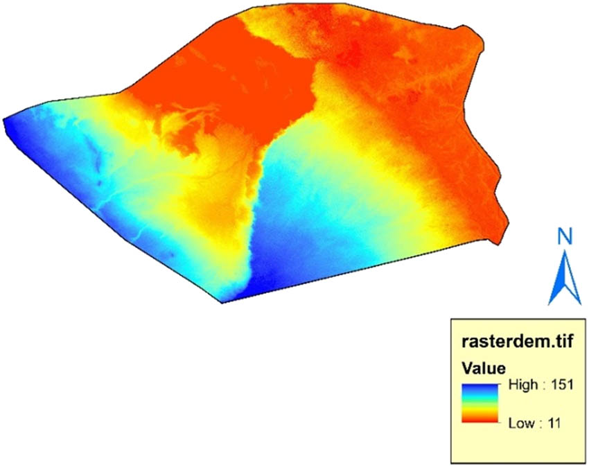
DEM Karbala province.
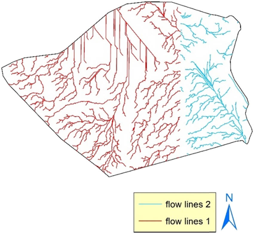
Flow lines Karbala province.
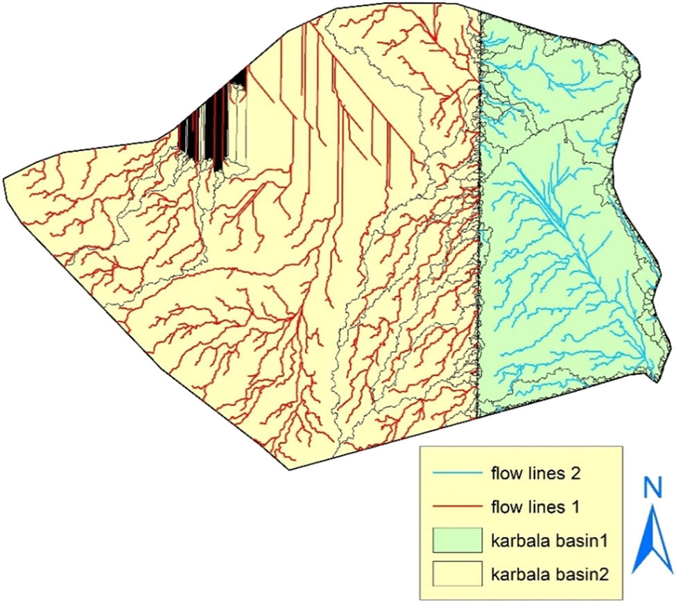
Catchment areas of Karbala city.
3.5 Rainfall data collection
Remote rainfall data investigation begins with reliable data. Users may access satellite imagery, meteorological stations, and precipitation models in ArcGIS. Open-source platforms or governmental meteorological data collection organizations could supply this data. Data integrity and accuracy from reliable sources are absolutely essential. In this article, data regarding rain falls is obtained from the CHRS library, which is presented in Figure 5. It is assumed that the rainfall data collected from remote sensing technology, like imagery taken by satellites. It has an acceptable level of accuracy.
![Figure 5
Precipitation data averaged over a wide range of years [2,5,18].](/document/doi/10.1515/eng-2024-0009/asset/graphic/j_eng-2024-0009_fig_005.jpg)
3.6 Data analysis
Rainfall data analysis includes visualization to improve water collection. Predictive models use historical data to forecast water supply and rainfall. To determine rainwater collection system locations, climate, geography, and hydrology are considered. Simulations of rainfall intensity assist select locations by assessing 5- and 19-year data variations. The analysis shows that rainfall intensity and location must be considered when choosing a site for rainwater collection systems to be effective and durable. This method addresses sustainable RWH system concerns using remote sensing, GIS analysis, and data visualization. In places with water scarcity and unpredictable precipitation, it improves controlling water supplies. Several essential criteria, including geography, hydrology, and rainfall intensity, have been selected for investigation due to their direct impact on rainwater availability and collection potential.
4 SRWH system challenges
The challenges associated with the implementation of SRWH systems through the utilization of remote sensing technology are varied and complex. The issues derive from the complicated characteristics of rainfall patterns, the constraints of remote sensing technologies, and the necessity for precise and reliable information to facilitate the design and administration of SRWH systems [26,31,34]. The following are a few significant challenges:
Data accuracy and resolution: Remote sensing captures rainfall data using satellite or aerial images. This data’s accuracy and resolution can fluctuate, rendering regional precipitation estimates inaccurate. To build and run SRWH systems accurately, high-resolution data are essential [36].
Time frame and territorial variability: Rainfall patterns fluctuate remarkably. Remote sensing could fail to capture variability adequately for an accurate estimation of rainfall temporal and geographical distribution. SRWH systems need precise rainfall timing and distribution data [32].
Cloud cover and interference: can block satellite photography, limiting real-time rainfall measurements. This phenomenon might be particularly difficult in cloudy or rainy places when precise data is required [26]. Furthermore, stream lines are visualized in Figure 2 to clarify the vision about the possibility of developing these streams into natural canals to serve a sustainable harvesting system [23].
Climate change: patterns of precipitation could shift, making historical statistics unreliable for planning. Adapting SRWH systems to changing climates and anticipating rainfall patterns is challenging [2].
Infrastructure and maintenance: SRWH systems required infrastructure and management. These systems must have periodic inspection of physical infrastructure including rainwater tanks or ponds. In certain places, building and sustaining these infrastructures becomes challenging [39].
5 Sustainable harvesting infrastructure site selection designation
Sustainable RWH implies an integrated strategy that prioritizes modifying harvesting systems according to rainfall intensity. This sustainable strategy became a greater hit as a sustainable solution to limited water availability, meeting urban and rural water needs [28].
Selecting an optimal site is the foundation of this technique. The selection of suitable sites is important for the performance of the RWH system. A detailed analysis of regional climate, terrain, and hydrology identifies the best rainwater collection system locations [23,28].
Reliable collecting systems are essential in locations with high rainfall variability. These systems could modify storage and drainage depending on rainfall intensity and frequency. During intense precipitation, the system must quickly accumulate and retain excess water to prevent flooding and erosion. However, during low precipitation, the system must efficiently use conserved water resources to ensure a steady supply for agriculture, sanitation, and household use [23,27,28,36].
This research suggests an alteration in site selection for harvesting systems to incorporate a simulation of rainfall intensity. Considering the previously mentioned data viewpoints (2, 5, and 19), the data visualization indicates that the site selected for the development of the system could not be suitable for meeting the 5- and 19-year data. Therefore, throughout the site selection process, it is important to systematically consider both the intensity of rainfall and its geographical location.
In summary, the concept of sustainable rainwater collection is centered on the strategic alteration of collection systems to effectively manage fluctuations in rainfall intensity. Through employing an efficient method of site selection, designing adaptable infrastructure, incorporating traditional knowledge alongside modern technology, and fostering active community engagement, these initiatives can successfully tackle the issue of water scarcity while simultaneously advancing environmental sustainability and enhancing resilience in response to shifting climate patterns [29,36].
6 Results and discussion
Data visualization for sustainable harvesting of rainwater was the primary objective of the article. To accomplish this objective, SRWH system practices and challenges have been assessed. The study further investigated how potential data visualization could enhance performance. Our research findings are as follows.
6.1 Current SRWH practices
In this decade, awareness of SRWH as a way to solve the water crisis and generate a sustainable water supply is expanding. The examination of current SRWH systems reveals a significant reliance on conventional methods of monitoring and reporting. The above techniques include traditional measurements of precipitation and water storage areas. This study (SRWH) takes advantage of remote sensing integrated with GIS to explore the present state of RWH practices, emphasizing the visualization of data associated with rainwater catchment areas around Karbala province. The data deployed in this analysis are obtained from academic organizations that include the USGS and CHRS databases. Results reveal that Karbala province could be divided into two main regions based on topographical data. This visualization of data enables decision-makers to identify areas that are optimal for RWH and utilization within a sustainable framework. The collected rainwater can be employed for various purposes, including agriculture and potable water systems; established, suitable treatment techniques are utilized. Figure 1 illustrates a DEM of the entire research area, highlighting locations that could potentially serve as water storage areas due to their valley-like elevation. These areas could be successfully used as natural harvesting tanks with appropriate adjustments. The darker red portion corresponds to a lower percentage of water collection zones, whereas the dark blue regions indicate a higher concentration of water-accumulating zones within the studied area. Based on the presented visual information, it is possible to extrapolate and choose the best suitable area for constructing sustainable RWH tanks. A variety of colures in the intermediate regions signifies the accumulation of an average amount of precipitation. Furthermore, Figure 3 shows how streamlines can be visualized, which is an important step toward realizing the possibility of turning these streams into natural drainage channels that could support a long-term harvesting system. The basins or catchment areas in Figure 4 could be visualized by employing the previously mentioned information and figuring out the catchment area’s location based on identified geographic boundaries using GIS and the data that is accessible.
6.2 Rainfall visualization
Visualizing rainfall patterns with GIS helps substantially benefit precipitation evaluation, governance, and management. This technology assists decision-makers in numerous sectors to optimize resource allocation, disaster safety, and sustainable development by providing valuable information. The data obtained by the CHRS organization consists of the application of a four-by-four-kilometer grid to measure and record rainfall information. Consequently, it has been observed that the resulting visualizations exhibit pixel-like characteristics. Figure 5 illustrates visualized rainfall data for the case study region. This study specifically examines Karbala province, in contrast to previous research that typically covers a wider geographic area. The study provides detailed instances of data visualization for DEM, streamlines, and catchment areas, delivering practical insights that may not be readily available in more general studies. Analyzed rainfall data from 2003 to 2021 in Karbala offers detailed insights that have not been identified in more general research. The study provides useful findings. Concentrating on a particular area, Karbala province, offering specific instances of data visualization for SRWH applications, and examining regional precipitation trends during a set time period. The insights enhance current research and provide practical examples for incorporating data visualization into sustainable RWH installations.
This article shares a visualization of rainfall details regarding the city of Karbala, spanning from the year 2003 to 2021. The study includes a graph of the average rainfall across the 19-year time frame as well as the visualization of rainfall occurrences across 5- and 2-year intervals.
The locations labeled with dark blue indicate the highest volume of rainfall, while the regions labeled with dark red reflect the lowest volume of rainfall. The locations labeled with colors in between represent an average amount of rainfall.
7 Conclusions
In brief, this article emphasizes the significant importance of data visualization in the framework of sustainable RWH. Through the utilization of GIS and remote sensing methodologies, decision-makers are empowered to make well-informed decisions on the most advantageous sites for RWH systems. Moreover, the utilization of rainfall visualizations provides important observations that are valuable in the management of resources and for planning for potential disasters. The article suggests modifying harvesting system site selection to simulate rainfall. The data visualization indicates that the site for 2-year average rainfall when it was constructed was insufficient for 5- and 19-year data; thus, site selection depends on rainfall intensity and location. The integration of data visualization technologies into environmentally friendly and accountable water management techniques offers the potential to enhance efficiency and promote sustainability in regions such as Karbala and other similar areas.
7.1 Recommendations
1. The use of remote sensing techniques can be used in the construction and study of sustainable RWH tanks and lakes.
2. To achieve sustainable management of water resources, it is imperative to utilize previous and future data provided by worldwide organizations, particularly future data.
3. The plan is to compare rainfall data with graphical data and conduct appropriate statistical analysis to minimize variations throughout the planning and design phases.
Acknowledgments
We express our sincere gratitude to the University of Kerbala and the University of Warith Al-Anbiyaa for their invaluable support and collaboration, which have been instrumental in the realization of this research endeavor. Their commitment to fostering mutual cooperation has provided us with the opportunity to delve into the critical realm of sustainable RWH through the lens of data visualization, with a particular focus on Karbala province. Special thanks are extended to the respective faculties of civil engineering departments at both institutions, whose expertise and resources have greatly enriched our research process. Their dedication to academic excellence has been an inspiration throughout this journey. Furthermore, we acknowledge the guidance and mentorship provided by our esteemed colleagues, whose insights have significantly contributed to the refinement of this study. Their unwavering support has been a source of encouragement at every step. Lastly, we extend our appreciation to all those who have contributed to this work, directly or indirectly, and to the wider academic community for their ongoing commitment to advancing knowledge and fostering sustainable development.
-
Funding information: The authors state no funding involved.
-
Author contributions: All authors have accepted responsibility for the entire content of this manuscript, consented to its submission to the journal, reviewed all the results, and approved the final version of the manuscript. AIA: conceptualization, methodology, investigation, writing, visualization, and software. BKN: conceptualization, writing – review and editing, and supervision. WHH: conceptualization, writing – review and editing, and supervision.
-
Conflict of interest: Authors state no conflict of interest.
-
Data availability statement: This study's datasets, measurements, and computational methods are available. If allowed, interested parties should contact [Al Ibraheemi Abbas] at [abbas.h.ali@s.uokerbala.edu]. We encourage more research and validation and promote transparency and repeatability.
References
[1] Zhou Q. A review of sustainable urban drainage systems considering the climate change and urbanization impacts. Water. 2014;6:976–92.10.3390/w6040976Search in Google Scholar
[2] Ward S, Butler D. Rainwater harvesting and social networks: visualising interactions for niche governance, resilience and sustainability. Water. 2016;8:526.10.3390/w8110526Search in Google Scholar
[3] Martínez-Acosta L, López-Lambraño ÁA, López-Ramos Á. Design criteria for planning the agricultural rainwater harvesting systems: a review. Appl Sci. 2019;9:5298.10.3390/app9245298Search in Google Scholar
[4] Rodríguez-Sinobas L, Zubelzu S, Perales-Momparler S, Canogar S. Techniques and criteria for sustainable urban stormwater management. The case study of Valdebebas (Madrid, Spain). J Clean Prod. 2018;172:402–16.10.1016/j.jclepro.2017.10.070Search in Google Scholar
[5] Mohsen KA, Nile BK, Hassan WH. Experimental work on improving the efficiency of storm networks using a new galley design filter bucket. IOP Conf Ser Mater Sci Eng. 2020;671(1):012094.10.1088/1757-899X/671/1/012094Search in Google Scholar
[6] Wadi WM, Nile BK, Hassan WH. Climate change effect on The South Iraq Stormwater Network. International Congress on Human-Computer Interaction, Optimization and Robotic Applications (HORA). IEEE; 2022.10.1109/HORA55278.2022.9799860Search in Google Scholar
[7] Hassan WH, Nile BK, Al-Masody BA. Climate change effect on storm drainage networks by storm water management model. Environ Eng Res. 2017;22(4):393–400.10.4491/eer.2017.036Search in Google Scholar
[8] Al-Khuzaie AH, Alyaseri IJ, Nile BK. Flood reduction using green infrastructure in stormwater sewer systems: A case study in Al-Samawa city. AIP Conference Proceedings. AIP Publishing; 2023.10.1063/5.0131325Search in Google Scholar
[9] Maurya SP, Singh PK, Ohri A, Singh RK. Identification of indicators for sustainable urban water development planning. Ecol Indic. 2020;108:105691.10.1016/j.ecolind.2019.105691Search in Google Scholar
[10] Nile BK, Hassan WH, Alshama GA. Analysis of the effect of climate change on rainfall intensity and expected flooding by using ANN and SWMM programs. ARPN J Eng Appl Sci. 2019;14(5):974–84.Search in Google Scholar
[11] de Sá Silva ACR, Bimbato AM, Balestieri JAP, Vilanova MRN. Exploring environmental, economic and social aspects of rainwater harvesting systems: A review. Sustain Cities Soc. 2022;76:103475.10.1016/j.scs.2021.103475Search in Google Scholar
[12] Roozbahani A, Behzadi P, Bavani AM. Analysis of performance criteria and sustainability index in urban stormwater systems under the impacts of climate change. J Clean Prod. 2020;271:122727.10.1016/j.jclepro.2020.122727Search in Google Scholar
[13] Teston A, Piccinini Scolaro T, Kuntz Maykot J, Ghisi E. Comprehensive environmental assessment of rainwater harvesting systems: a literature review. Water. 2022;14:2716.10.3390/w14172716Search in Google Scholar
[14] Silva ADd, Mendes R, Bello LAL, Farias ALA. Sustainability of rain water supply technologies: a methodology applied to Belém county islands. Rev Tecnologia e Sociedade. 2018;14:34. 10.3895/rts.v14n34.7839Search in Google Scholar
[15] AL-Hamami A, Nile K, BH, Al-Baidhani J. The effect of high intensities of rainfall on the operation of the combined sewage system in populated areas. Kerbala J Eng Sci. 2021;1(1):75–92.Search in Google Scholar
[16] Alamri SNHS, Nile BK, Zwain HM. Topographic effects on stormwater drainage under different rainfall intensities case study of Al-Najaf City. Kerbala J Eng Sci. 2021;1(2):191–201.Search in Google Scholar
[17] Dibs H, Jaber HS, Al-Ansari N. Multi-fusion algorithms for detecting land surface pattern changes using multi-high spatial resolution images and remote sensing analysis. Emerg Sci J. 2023;7(4):1215–31.10.28991/ESJ-2023-07-04-013Search in Google Scholar
[18] Dibs H, Ali AH, Al-Ansari N, Abed SA. Fusion Landsat-8 thermal TIRS and OLI datasets for superior monitoring and change detection using remote sensing. Emerg Sci J. 2023;7(2):428–4.10.28991/ESJ-2023-07-02-09Search in Google Scholar
[19] Cacal JC, Austria VCA, Taboada EB. Extreme event-based rainfall-runoff simulation utilizing GIS techniques in Irawan Watershed, Palawan, Philippines. Civ Eng J. 2023;9(1):220–32.10.28991/CEJ-2023-09-01-017Search in Google Scholar
[20] Rosly MH, Mohamad HM, Bolong N, Harith NSH. Relationship of rainfall intensity with slope stability. Civ Eng J. 2023;9:75–82.10.28991/CEJ-SP2023-09-06Search in Google Scholar
[21] Nayel M, Nile B, Al-Hamami H. Estimation of the floods that occur in the drainage network during the rainy season. J Eng Appl Sci. 2018;13:8178–87.Search in Google Scholar
[22] Majeed AR, Nile BK, Al-Baidhani JH. Selection of suitable PDF model and build of IDF curves for rainfall in Najaf city, Iraq. J Phys: Conf Ser. 2021;1973(1):012184.10.1088/1742-6596/1973/1/012184Search in Google Scholar
[23] Ya’acob ME, Zulkifli SA, Zulkifli N, Iskandar AN, Othman MH, Zaidi MLA. GIS mapping for rainwater harvesting in ground-mounted large scale solar PV farms. 2022 IEEE International Conference in Power Engineering Application (ICPEA); 2022. p. 1–6.10.1109/ICPEA53519.2022.9744708Search in Google Scholar
[24] Tiwari KP, Goyal R, Sarkar A. GIS-based methodology for identification of suitable locations for rainwater harvesting structures. Water Resour Manag. 2018;32:1811–25.10.1007/s11269-018-1905-9Search in Google Scholar
[25] Sayl KN, Mohammed AS, Ahmed AD. GIS-based approach for rainwater harvesting site selection. IOP Conference Series: Materials Science and Engineering; 2020. p. 737.10.1088/1757-899X/737/1/012246Search in Google Scholar
[26] Chiu Y-R, Liaw C-H, Hu C-Y, Tsai Y-L, Chang H-H. Applying GIS-based rainwater harvesting design system in the water-energy conservation scheme for large cities. 2009 13th International Conference on Computer Supported Cooperative Work in Design; 2009. p. 722–7.10.1109/CSCWD.2009.4968144Search in Google Scholar
[27] Baby SN, Arrowsmith C, Al‐Ansari N. Application of GIS for mapping rainwater-harvesting potential: case study wollert. Vic Eng. 2019.10.4236/eng.2019.111002Search in Google Scholar
[28] Ziadat FM, Bruggeman A, Oweis TY, Haddad NI, Mazahreh S, Sartawi W, et al. A participatory GIS approach for assessing land suitability for rainwater harvesting in an arid rangeland environment. Arid LRes Manag. 2012;26:297–311.10.1080/15324982.2012.709214Search in Google Scholar
[29] Raj S. Rain Water Harvesting Potential of Pallavapuram Area of Meerut: A GIS Study. 12th Esri India User Conference; 2011.Search in Google Scholar
[30] Preeti P, Rahman A. Application of GIS in rainwater harvesting research: a scoping review. Asian J Water Environ Pollut. 2021;18(4):29–35.10.3233/AJW210040Search in Google Scholar
[31] Karani R, Joshi A, Joshi M, Velury S, Shah S. Optimization of rainwater harvesting sites using GIS. International Conference on Geographical Information Systems Theory, Applications and Management; 2019.10.5220/0007722302280233Search in Google Scholar
[32] Hari D, Ramamohan Reddy K, Vikas K, Srinivas N, Vikas G. Assessment of rainwater harvesting potential using GIS. IOP Conference Series: Materials Science and Engineering; 2018. p. 330.10.1088/1757-899X/330/1/012119Search in Google Scholar
[33] Gaikwad SD. Application of remote sensing and GIS in rainwater harvesting: A case from Goa. India: IJSER; 2015.Search in Google Scholar
[34] Choudhary S, Chouhan SS, Jain M, Panchal K, Bhardwaj Y. Development of rain water harvesting system through national highway profiles by using gis and field survey. Sustain Technol eJournal. 2019. 10.2139/ssrn.3348303.Search in Google Scholar
[35] Chiu Y-R, Tsai Y-L, Chiang Y-C. Designing rainwater harvesting systems cost-effectively in a urban water-energy saving scheme by using a GIS-simulation based design system. Water. 2015;7:6285–300.10.3390/w7116285Search in Google Scholar
[36] Ahmad M-uD. Site Suitability analysis using remote sensing & GIS for rain water harvesting. India: IJSER; 2016.Search in Google Scholar
[37] Nile BK. Effectiveness of hydraulic and hydrologic parameters in assessing storm system flooding. Adv Civ Eng. 2018;2018:1–17.10.1155/2018/4639172Search in Google Scholar
[38] He C-H, Liu C, He J-H, Shirazi AH, Mohammad-Sedighi H. Passive atmospheric water harvesting utilizing an ancient Chinese ink slab. Facta Universitatis, Series: Mech Eng. 2021;19(2):229–39.10.22190/FUME201203001HSearch in Google Scholar
[39] Rentachintala LRNP, Reddy MGM, Mohapatra PK. Urban stormwater management for sustainable and resilient measures and practices: a review. Water Sci Technol: A J Int Assoc Water Pollut Res. 2022;85(4):1120–40.10.2166/wst.2022.017Search in Google Scholar PubMed
© 2024 the author(s), published by De Gruyter
This work is licensed under the Creative Commons Attribution 4.0 International License.
Articles in the same Issue
- Regular Articles
- Methodology of automated quality management
- Influence of vibratory conveyor design parameters on the trough motion and the self-synchronization of inertial vibrators
- Application of finite element method in industrial design, example of an electric motorcycle design project
- Correlative evaluation of the corrosion resilience and passivation properties of zinc and aluminum alloys in neutral chloride and acid-chloride solutions
- Will COVID “encourage” B2B and data exchange engineering in logistic firms?
- Influence of unsupported sleepers on flange climb derailment of two freight wagons
- A hybrid detection algorithm for 5G OTFS waveform for 64 and 256 QAM with Rayleigh and Rician channels
- Effect of short heat treatment on mechanical properties and shape memory properties of Cu–Al–Ni shape memory alloy
- Exploring the potential of ammonia and hydrogen as alternative fuels for transportation
- Impact of insulation on energy consumption and CO2 emissions in high-rise commercial buildings at various climate zones
- Advanced autopilot design with extremum-seeking control for aircraft control
- Adaptive multidimensional trust-based recommendation model for peer to peer applications
- Effects of CFRP sheets on the flexural behavior of high-strength concrete beam
- Enhancing urban sustainability through industrial synergy: A multidisciplinary framework for integrating sustainable industrial practices within urban settings – The case of Hamadan industrial city
- Advanced vibrant controller results of an energetic framework structure
- Application of the Taguchi method and RSM for process parameter optimization in AWSJ machining of CFRP composite-based orthopedic implants
- Improved correlation of soil modulus with SPT N values
- Technologies for high-temperature batch annealing of grain-oriented electrical steel: An overview
- Assessing the need for the adoption of digitalization in Indian small and medium enterprises
- A non-ideal hybridization issue for vertical TFET-based dielectric-modulated biosensor
- Optimizing data retrieval for enhanced data integrity verification in cloud environments
- Performance analysis of nonlinear crosstalk of WDM systems using modulation schemes criteria
- Nonlinear finite-element analysis of RC beams with various opening near supports
- Thermal analysis of Fe3O4–Cu/water over a cone: a fractional Maxwell model
- Radial–axial runner blade design using the coordinate slice technique
- Theoretical and experimental comparison between straight and curved continuous box girders
- Effect of the reinforcement ratio on the mechanical behaviour of textile-reinforced concrete composite: Experiment and numerical modeling
- Experimental and numerical investigation on composite beam–column joint connection behavior using different types of connection schemes
- Enhanced performance and robustness in anti-lock brake systems using barrier function-based integral sliding mode control
- Evaluation of the creep strength of samples produced by fused deposition modeling
- A combined feedforward-feedback controller design for nonlinear systems
- Effect of adjacent structures on footing settlement for different multi-building arrangements
- Analyzing the impact of curved tracks on wheel flange thickness reduction in railway systems
- Review Articles
- Mechanical and smart properties of cement nanocomposites containing nanomaterials: A brief review
- Applications of nanotechnology and nanoproduction techniques
- Relationship between indoor environmental quality and guests’ comfort and satisfaction at green hotels: A comprehensive review
- Communication
- Techniques to mitigate the admission of radon inside buildings
- Erratum
- Erratum to “Effect of short heat treatment on mechanical properties and shape memory properties of Cu–Al–Ni shape memory alloy”
- Special Issue: AESMT-3 - Part II
- Integrated fuzzy logic and multicriteria decision model methods for selecting suitable sites for wastewater treatment plant: A case study in the center of Basrah, Iraq
- Physical and mechanical response of porous metals composites with nano-natural additives
- Special Issue: AESMT-4 - Part II
- New recycling method of lubricant oil and the effect on the viscosity and viscous shear as an environmentally friendly
- Identify the effect of Fe2O3 nanoparticles on mechanical and microstructural characteristics of aluminum matrix composite produced by powder metallurgy technique
- Static behavior of piled raft foundation in clay
- Ultra-low-power CMOS ring oscillator with minimum power consumption of 2.9 pW using low-voltage biasing technique
- Using ANN for well type identifying and increasing production from Sa’di formation of Halfaya oil field – Iraq
- Optimizing the performance of concrete tiles using nano-papyrus and carbon fibers
- Special Issue: AESMT-5 - Part II
- Comparative the effect of distribution transformer coil shape on electromagnetic forces and their distribution using the FEM
- The complex of Weyl module in free characteristic in the event of a partition (7,5,3)
- Restrained captive domination number
- Experimental study of improving hot mix asphalt reinforced with carbon fibers
- Asphalt binder modified with recycled tyre rubber
- Thermal performance of radiant floor cooling with phase change material for energy-efficient buildings
- Surveying the prediction of risks in cryptocurrency investments using recurrent neural networks
- A deep reinforcement learning framework to modify LQR for an active vibration control applied to 2D building models
- Evaluation of mechanically stabilized earth retaining walls for different soil–structure interaction methods: A review
- Assessment of heat transfer in a triangular duct with different configurations of ribs using computational fluid dynamics
- Sulfate removal from wastewater by using waste material as an adsorbent
- Experimental investigation on strengthening lap joints subjected to bending in glulam timber beams using CFRP sheets
- A study of the vibrations of a rotor bearing suspended by a hybrid spring system of shape memory alloys
- Stability analysis of Hub dam under rapid drawdown
- Developing ANFIS-FMEA model for assessment and prioritization of potential trouble factors in Iraqi building projects
- Numerical and experimental comparison study of piled raft foundation
- Effect of asphalt modified with waste engine oil on the durability properties of hot asphalt mixtures with reclaimed asphalt pavement
- Hydraulic model for flood inundation in Diyala River Basin using HEC-RAS, PMP, and neural network
- Numerical study on discharge capacity of piano key side weir with various ratios of the crest length to the width
- The optimal allocation of thyristor-controlled series compensators for enhancement HVAC transmission lines Iraqi super grid by using seeker optimization algorithm
- Numerical and experimental study of the impact on aerodynamic characteristics of the NACA0012 airfoil
- Effect of nano-TiO2 on physical and rheological properties of asphalt cement
- Performance evolution of novel palm leaf powder used for enhancing hot mix asphalt
- Performance analysis, evaluation, and improvement of selected unsignalized intersection using SIDRA software – Case study
- Flexural behavior of RC beams externally reinforced with CFRP composites using various strategies
- Influence of fiber types on the properties of the artificial cold-bonded lightweight aggregates
- Experimental investigation of RC beams strengthened with externally bonded BFRP composites
- Generalized RKM methods for solving fifth-order quasi-linear fractional partial differential equation
- An experimental and numerical study investigating sediment transport position in the bed of sewer pipes in Karbala
- Role of individual component failure in the performance of a 1-out-of-3 cold standby system: A Markov model approach
- Implementation for the cases (5, 4) and (5, 4)/(2, 0)
- Center group actions and related concepts
- Experimental investigation of the effect of horizontal construction joints on the behavior of deep beams
- Deletion of a vertex in even sum domination
- Deep learning techniques in concrete powder mix designing
- Effect of loading type in concrete deep beam with strut reinforcement
- Studying the effect of using CFRP warping on strength of husk rice concrete columns
- Parametric analysis of the influence of climatic factors on the formation of traditional buildings in the city of Al Najaf
- Suitability location for landfill using a fuzzy-GIS model: A case study in Hillah, Iraq
- Hybrid approach for cost estimation of sustainable building projects using artificial neural networks
- Assessment of indirect tensile stress and tensile–strength ratio and creep compliance in HMA mixes with micro-silica and PMB
- Density functional theory to study stopping power of proton in water, lung, bladder, and intestine
- A review of single flow, flow boiling, and coating microchannel studies
- Effect of GFRP bar length on the flexural behavior of hybrid concrete beams strengthened with NSM bars
- Exploring the impact of parameters on flow boiling heat transfer in microchannels and coated microtubes: A comprehensive review
- Crumb rubber modification for enhanced rutting resistance in asphalt mixtures
- Special Issue: AESMT-6
- Design of a new sorting colors system based on PLC, TIA portal, and factory I/O programs
- Forecasting empirical formula for suspended sediment load prediction at upstream of Al-Kufa barrage, Kufa City, Iraq
- Optimization and characterization of sustainable geopolymer mortars based on palygorskite clay, water glass, and sodium hydroxide
- Sediment transport modelling upstream of Al Kufa Barrage
- Study of energy loss, range, and stopping time for proton in germanium and copper materials
- Effect of internal and external recycle ratios on the nutrient removal efficiency of anaerobic/anoxic/oxic (VIP) wastewater treatment plant
- Enhancing structural behaviour of polypropylene fibre concrete columns longitudinally reinforced with fibreglass bars
- Sustainable road paving: Enhancing concrete paver blocks with zeolite-enhanced cement
- Evaluation of the operational performance of Karbala waste water treatment plant under variable flow using GPS-X model
- Design and simulation of photonic crystal fiber for highly sensitive chemical sensing applications
- Optimization and design of a new column sequencing for crude oil distillation at Basrah refinery
- Inductive 3D numerical modelling of the tibia bone using MRI to examine von Mises stress and overall deformation
- An image encryption method based on modified elliptic curve Diffie-Hellman key exchange protocol and Hill Cipher
- Experimental investigation of generating superheated steam using a parabolic dish with a cylindrical cavity receiver: A case study
- Effect of surface roughness on the interface behavior of clayey soils
- Investigated of the optical properties for SiO2 by using Lorentz model
- Measurements of induced vibrations due to steel pipe pile driving in Al-Fao soil: Effect of partial end closure
- Experimental and numerical studies of ballistic resistance of hybrid sandwich composite body armor
- Evaluation of clay layer presence on shallow foundation settlement in dry sand under an earthquake
- Optimal design of mechanical performances of asphalt mixtures comprising nano-clay additives
- Advancing seismic performance: Isolators, TMDs, and multi-level strategies in reinforced concrete buildings
- Predicted evaporation in Basrah using artificial neural networks
- Energy management system for a small town to enhance quality of life
- Numerical study on entropy minimization in pipes with helical airfoil and CuO nanoparticle integration
- Equations and methodologies of inlet drainage system discharge coefficients: A review
- Thermal buckling analysis for hybrid and composite laminated plate by using new displacement function
- Investigation into the mechanical and thermal properties of lightweight mortar using commercial beads or recycled expanded polystyrene
- Experimental and theoretical analysis of single-jet column and concrete column using double-jet grouting technique applied at Al-Rashdia site
- The impact of incorporating waste materials on the mechanical and physical characteristics of tile adhesive materials
- Seismic resilience: Innovations in structural engineering for earthquake-prone areas
- Automatic human identification using fingerprint images based on Gabor filter and SIFT features fusion
- Performance of GRKM-method for solving classes of ordinary and partial differential equations of sixth-orders
- Visible light-boosted photodegradation activity of Ag–AgVO3/Zn0.5Mn0.5Fe2O4 supported heterojunctions for effective degradation of organic contaminates
- Production of sustainable concrete with treated cement kiln dust and iron slag waste aggregate
- Key effects on the structural behavior of fiber-reinforced lightweight concrete-ribbed slabs: A review
- A comparative analysis of the energy dissipation efficiency of various piano key weir types
- Special Issue: Transport 2022 - Part II
- Variability in road surface temperature in urban road network – A case study making use of mobile measurements
- Special Issue: BCEE5-2023
- Evaluation of reclaimed asphalt mixtures rejuvenated with waste engine oil to resist rutting deformation
- Assessment of potential resistance to moisture damage and fatigue cracks of asphalt mixture modified with ground granulated blast furnace slag
- Investigating seismic response in adjacent structures: A study on the impact of buildings’ orientation and distance considering soil–structure interaction
- Improvement of porosity of mortar using polyethylene glycol pre-polymer-impregnated mortar
- Three-dimensional analysis of steel beam-column bolted connections
- Assessment of agricultural drought in Iraq employing Landsat and MODIS imagery
- Performance evaluation of grouted porous asphalt concrete
- Optimization of local modified metakaolin-based geopolymer concrete by Taguchi method
- Effect of waste tire products on some characteristics of roller-compacted concrete
- Studying the lateral displacement of retaining wall supporting sandy soil under dynamic loads
- Seismic performance evaluation of concrete buttress dram (Dynamic linear analysis)
- Behavior of soil reinforced with micropiles
- Possibility of production high strength lightweight concrete containing organic waste aggregate and recycled steel fibers
- An investigation of self-sensing and mechanical properties of smart engineered cementitious composites reinforced with functional materials
- Forecasting changes in precipitation and temperatures of a regional watershed in Northern Iraq using LARS-WG model
- Experimental investigation of dynamic soil properties for modeling energy-absorbing layers
- Numerical investigation of the effect of longitudinal steel reinforcement ratio on the ductility of concrete beams
- An experimental study on the tensile properties of reinforced asphalt pavement
- Self-sensing behavior of hot asphalt mixture with steel fiber-based additive
- Behavior of ultra-high-performance concrete deep beams reinforced by basalt fibers
- Optimizing asphalt binder performance with various PET types
- Investigation of the hydraulic characteristics and homogeneity of the microstructure of the air voids in the sustainable rigid pavement
- Enhanced biogas production from municipal solid waste via digestion with cow manure: A case study
- Special Issue: AESMT-7 - Part I
- Preparation and investigation of cobalt nanoparticles by laser ablation: Structure, linear, and nonlinear optical properties
- Seismic analysis of RC building with plan irregularity in Baghdad/Iraq to obtain the optimal behavior
- The effect of urban environment on large-scale path loss model’s main parameters for mmWave 5G mobile network in Iraq
- Formatting a questionnaire for the quality control of river bank roads
- Vibration suppression of smart composite beam using model predictive controller
- Machine learning-based compressive strength estimation in nanomaterial-modified lightweight concrete
- In-depth analysis of critical factors affecting Iraqi construction projects performance
- Behavior of container berth structure under the influence of environmental and operational loads
- Energy absorption and impact response of ballistic resistance laminate
- Effect of water-absorbent polymer balls in internal curing on punching shear behavior of bubble slabs
- Effect of surface roughness on interface shear strength parameters of sandy soils
- Evaluating the interaction for embedded H-steel section in normal concrete under monotonic and repeated loads
- Estimation of the settlement of pile head using ANN and multivariate linear regression based on the results of load transfer method
- Enhancing communication: Deep learning for Arabic sign language translation
- A review of recent studies of both heat pipe and evaporative cooling in passive heat recovery
- Effect of nano-silica on the mechanical properties of LWC
- An experimental study of some mechanical properties and absorption for polymer-modified cement mortar modified with superplasticizer
- Digital beamforming enhancement with LSTM-based deep learning for millimeter wave transmission
- Developing an efficient planning process for heritage buildings maintenance in Iraq
- Design and optimization of two-stage controller for three-phase multi-converter/multi-machine electric vehicle
- Evaluation of microstructure and mechanical properties of Al1050/Al2O3/Gr composite processed by forming operation ECAP
- Calculations of mass stopping power and range of protons in organic compounds (CH3OH, CH2O, and CO2) at energy range of 0.01–1,000 MeV
- Investigation of in vitro behavior of composite coating hydroxyapatite-nano silver on 316L stainless steel substrate by electrophoretic technic for biomedical tools
- A review: Enhancing tribological properties of journal bearings composite materials
- Improvements in the randomness and security of digital currency using the photon sponge hash function through Maiorana–McFarland S-box replacement
- Design a new scheme for image security using a deep learning technique of hierarchical parameters
- Special Issue: ICES 2023
- Comparative geotechnical analysis for ultimate bearing capacity of precast concrete piles using cone resistance measurements
- Visualizing sustainable rainwater harvesting: A case study of Karbala Province
- Geogrid reinforcement for improving bearing capacity and stability of square foundations
- Evaluation of the effluent concentrations of Karbala wastewater treatment plant using reliability analysis
- Adsorbent made with inexpensive, local resources
- Effect of drain pipes on seepage and slope stability through a zoned earth dam
- Sediment accumulation in an 8 inch sewer pipe for a sample of various particles obtained from the streets of Karbala city, Iraq
- Special Issue: IETAS 2024 - Part I
- Analyzing the impact of transfer learning on explanation accuracy in deep learning-based ECG recognition systems
- Effect of scale factor on the dynamic response of frame foundations
- Improving multi-object detection and tracking with deep learning, DeepSORT, and frame cancellation techniques
- The impact of using prestressed CFRP bars on the development of flexural strength
- Assessment of surface hardness and impact strength of denture base resins reinforced with silver–titanium dioxide and silver–zirconium dioxide nanoparticles: In vitro study
- A data augmentation approach to enhance breast cancer detection using generative adversarial and artificial neural networks
- Modification of the 5D Lorenz chaotic map with fuzzy numbers for video encryption in cloud computing
- Special Issue: 51st KKBN - Part I
- Evaluation of static bending caused damage of glass-fiber composite structure using terahertz inspection