Multi-scenario territorial spatial simulation and dynamic changes: A case study of Jilin Province in China from 1985 to 2030
-
Dan Shi


Abstract
Territorial spatial resource changes play an irreplaceable role in the human development process, providing the necessary dependency conditions and ecosystem services for human production and life. This article takes Jilin Province, China, as the study area, analyzes the characteristics of the dynamic evolution of territorial spatial in Jilin Province from 1985 to 2020, and simulates the spatial and temporal changes of land space in Jilin Province under three different scenarios in 2030. The results show that: (1) From 1985 to 2020, the productive space (PS) and living space (LS) show a gradual increase trend; the ecological space (ES) shows a decrease trend. The LS is scattered except in the Changbai Mountain area; the PS is mainly concentrated in the west and expands year by year; the ES is mainly in the east, and its scope shrinks year by year. (2) From 1985 to 2020, the center of gravity of PS changes more slowly and moves northward as a whole. The change of the center of gravity of LS is mainly concentrated in Changchun, and its center of gravity is shifting southward. The center of gravity of ES moves more sharply, first to the northwest and then gradually to the southeast. (3) Under the natural development scenario in 2030, the territorial spatial area fluctuation is mainly in the north of Songyuan City, central Jilin City, and the north of Changchun City. Under the ecological protection scenario, the area dynamics of Changchun City, Songyuan City, and the northwestern part of Baicheng City change significantly. Under the economic development scenario, the hotspot areas of spatial area change are mainly in the western part of Jilin Province.
1 Introduction
Territorial spatial, as a basis for human survival and livelihood, is a system of human–land relationship with multi-dimensional characteristics formed by the coupling of the human and natural environment and then evolves into a space with different attributes and functions [1]. It is not only the origin of civilization but also an important part of global environmental change, with the characteristics of comprehensiveness, integrity, fixedness, and scarcity [2]. The rapid national and socio-economic development in recent years and the limited territorial spatial resources of the country along the further exploitation of human beings have led to the intensification of competition between some regions, which is diametrically opposed to today’s global realization of the concept of sustainable development and the long-term planning of human social development. The functional areas formed by various urban activities constitute the basic framework of urban spatial structure, and the productive–living–ecological spaces (PLES) are the functional spaces divided according to the service functions [3]. Among them, the space with a supply function is the productive space (PS). The space with living function is the living space (LS), including the space for learning, working, socializing, home, and other activities. The ecological space (ES) refers to the ecological space of the region’s territorial spatial, which is closely related to the elements of geomorphology, hydrology, and vegetation [4]. However, excessive socio-economic activities have led to inefficient utilization of PS, poor livability, severe compression of ES, and incoherence of different spaces in terms of scale ratio, spatial configuration, and functional integration [5]. How to optimize the PLES, achieve sustainable development, and adjust the layout of spatial structure has become a hot spot for research on national land space [6,7].
Territorial spatial prediction models are based on land for analysis. In addition, summarizing past development patterns and describing, explaining, and predicting future territorial spatial changes is the main significance of their research [8]. Many studies have been conducted in this area, and scholars have used CA (CA-Markov) models, land use conversion matrix, and impact models within the study area to simulate urban land use evolution [9]. These studies complement simulated prediction studies in small regions. In many studies, the “productive–living–ecological” function is a technical tool for land use planning and spatial zoning management. In some national land spatial planning studies, development is traditionally managed by local governments through basic planning and regulatory tools such as comprehensive plans, zoning regulations, subdivision regulations, and capital improvement plans [10]. Some scholars began to study the changes in urban land spatial use earlier, and they divided social functions into some capabilities such as human health, culture, recreation, and aesthetic values. Economic functions were categorized into functions such as residence, productive value of land, and productive functions of land and transportation, which laid the foundation for the classification of the PLES [11]. Chinese scholars have done a lot of research on the system of classifying the PLES, spanning multiple scales such as national, provincial, urban cluster, city, county, and village and town. And they have made important theoretical achievements [12,13]. The PLES interact and complement each other. How to balance and coordinate the territorial spatial, form a scientific and reasonable layout structure, promote the coordinated and optimized development of the PLES, adjust the spatial structure of the PLES, and improve the efficiency of territorial spatial utilization has become a major proposition for the coordinated and sustainable development of the region [14].
The current academic research on the evolution of territorial spatial patterns is mostly focused on areas with distinctive anthropogenic characteristics or more developed economies [15,16]. As an old industrial base, Jilin Province has certain advantages of revitalization. However, it is also plagued by the imbalance between rapid economic development and spatial development and utilization of land [17]. The traditional spatial pattern of land use is only summarizing the “past rules,” but it cannot predict and evaluate the future spatial pattern of land in Jilin Province from the perspective of the PLES under the new situation. Therefore, the scientific prediction of changes in the spatial pattern of the national territory is the focus of research [18,19]. The data collection, analysis, and evaluation of land use changes in Jilin Province from 1985 to 2020 are scientifically conducted, and on this basis, multiple scenarios of land use in Jilin Province in 2030 are predicted by combining various driving factors of land spatial changes. It will reveal the spatial–temporal pattern of land use in the region and provide some support for the optimization of the ecological environment, industrial structure adjustment, balanced development of functional areas, and orderly and sustainable development of land use in Jilin Province.
This article analyzes and studies the quantitative changes, shift characteristics, and center of gravity changes of territorial spatial in Jilin Province from the perspective of the PLES. And using the future land - use simulation (FLUS) model to predict the evolution of territorial spatial patterns in Jilin Province in 2030 under multiple scenarios by combining the driving factors of territorial spatial changes. Based on the spatial evolution of land in Jilin Province, combining the local actual situation and national policies, the problems in the process of land utilization in Jilin Province are deeply excavated and condensed. We can provide a scientific basis and theoretical foundation for adjusting the layout of urban land, reasonably determining the development intensity of land and promoting the harmonious development of land and space [20,21]. It is conducive to the future rational development of a territorial spatial, scientific formulation of spatial management rules, and the realization of sustainable development of the ecological environment [22].
2 Materials and methods
2.1 Study area
Jilin Province is located in the central part of Northeast China, covering an area of 187,400 km2, with a total population of 25,596,000. It now has eight prefecture-level cities and the Yanbian Korean Autonomous Prefecture and contains two county-level cities directly under the jurisdiction of Mehekou and Gongzhuling (Figure 1). Jilin Province has a temperate continental monsoon climate, with obvious seasonal changes and differences in climate from southeast to northwest, from humid to semi-humid to semi-arid. The eastern part of the province is dominated by mountains, while the central and western parts are mostly plain landscapes. The landforms are mainly composed of volcanic landforms, erosion, and denudation landforms, alluvial landforms, and alluvial plains landforms. In addition, Jilin Province is rich in animal and plant resources. So far, terrestrial wildlife accounts for about 17.66% of all types of wildlife in the country. There are more than 270 species of lichens, 900 species of fungi, 140 species of ferns, 30 species of gymnosperms, and 2,200 species of angiosperms here. The area of arable land is 7.03 million hectares, with about 83.2 ha of black soil arable land; 9.376 million ha of forestry land, with 8.22 million ha of forested land and a forest coverage rate of 44.2%; 690,000 ha of grassland, with more than 70% of usable grassland; 1.728 million ha of wetlands, including 1.025 million hectares of natural wetlands; 265,500 ha of water surface of rivers and lakes (Jilin Province 2019). By the end of 2022, the province achieved an annual regional GDP of 130.724 billion yuan. Due to the impact of excessive human socio-economic activities, the territorial spatial changes in Jilin Province are more significant.

Schematic diagram of Jilin research area.
2.2 Data sources
This article focuses on the spatial–temporal pattern evolution and multi-scenario simulation prediction of Jilin Province. The analysis requires remote sensing data, vector data such as road networks and rivers, socio-economic data, and digital elevation data (DEM). The remote sensing images selected for the study were obtained from the US Geological Survey (https://www.usgs.gov/). The satellite type is Landsat TM/OLI/ETM+ images with 30 m resolution and the years are 1985, 2000, 2010, and 2020 in order. Digital elevation data were obtained from the Geospatial Data Cloud (http://www.gscloud.cn/). Socio-economic data were obtained from the Jilin Provincial Statistical Yearbook and the gazette of each county and district (http://tjj.jl.gov.cn/tjsj/tjnj/). Vector data were obtained from the Resource and Environment Science Data Center of the Chinese Academy of Sciences (https://www.resdc.cn/) and some fieldwork data.
The spatial pattern of land evolves under the joint action of natural and socio-economic factors, and the changes take a long time and are complex. The study is based on the current state data of land space utilization in Jilin Province in 1985, 2000, 2010, and 2020. It is based on the principles of feasibility, comprehensiveness, consistency, spatial differentiation, relevance, etc., to select scientific driving factors of territorial spatial in Jilin Province [21,23,24,25]. To provide a basis for the preparation of the FLUS model, a total of ten drivers were selected, including location, natural, and socio-economic factors (Figure 2). The topographic data involved are elevation, slope, and direction of slope. Elevations were obtained using SRTM 30 m resolution DEM data, and slopes and slope directions were derived from the DEM data. Distance data for transport, water systems, cities, etc., are calculated by the Euclidean distance method, in which the water system is based on the criteria for a Class V water system. Economic and social data, such as population density, GDP, and so on, are obtained from the Jilin Provincial Statistical Yearbook.

Driving factors. (a) DEM, (b) slope, (c) aspect, (d) distance to rivers, (e) distance to lakes, (f) distance to city, (g) distance to railway, (h) distance to highway, (i) population density, and (j) GDP.
2.3 Research methodology
This article mainly constructs the FLUS model, based on the dynamic evolution development trend of territorial spatial in Jilin Province from 1985 to 2020, combines the driving factors such as natural environment factors, socio-economic factors, and accessibility factors, and selecting the driving factors of relevance, dominance, and rationalization, to obtain the appropriateness probability of various types of territorial spatial utilization, and calculates to get the future of each space type of Jilin Province’s territorial spatial demand. It also simulates and predicts the future trend of territorial spatial structure in Jilin Province with multiple scenarios (natural development scenario, economic development scenario, and ecological protection scenario). Finally, hotspot analyses of the prediction results are carried out. It provides important guidance for the coordination of regional sustainable development and scientific development of land resources.
2.3.1 FLUS model
The FLUS model is a roulette wheel selection algorithm model based on meta-cellular automata [26] to predict future territorial space utilization scenarios. The BP neural network algorithm is used to calculate the suitability probability by combining the driving factors (temperature, precipitation, elevation, slope, traffic, location, population, policy, etc.). The Markov model is used to predict the number of image elements for each land space type in a year [27]. The adaptive inertia competition mechanism chosen by roulette can handle the uncertainty and complexity of the simulation [28]. The BP neural network algorithm consists of three layers [29]. The input layer is mainly the driving factor for the change of the territorial spatial type. The implied layer is the number of different natural resources, territorial spatial types, etc., in each region. The neurons in the output layer correspond to the territorial spatial types. The Markov model is a statistical model, which is widely used in the simulation of future prediction of territorial spatial types in combination with the meta-cellular automata model [30]. The meta-cellular automata model is one of the important tools for nonlinear scientific research [31]. In this study, the FLUS model is based on the initial territorial spatial utilization data with driving factors, and the development probabilities are combined with adaptive inertia coefficients, conversion costs, and domain factors to obtain the final results using a roulette wheel competition mechanism.
2.3.1.1 Neural network-based suitability probability of territorial spatial use types
The BP neural network algorithm is the most important part of the FLUS model, which includes three layers. The input layer is mainly the driving factor for the change of territorial spatial type; the implicit layer is the number of different natural resources, territorial spatial type, etc., in each region; and the neurons in the output layer correspond to the territorial spatial type [32]. The probability of suitability of different land use types is estimated by one-to-one correspondence between the input layer and the spatial data of the driving factors, and the output layer and the land use types. It is to establish the relationship between the initial territorial spatial use types and the role of each driving factor in space (equation (1)).
In equation (1), (
2.3.1.2 Scenario simulation of territorial spatial utilization types in 2030
The FLUS model is used to realize the distribution of the future territorial spatial use types of image elements and simulate the change of territorial spatial use (equation (2)).
In equation (2),
2.3.2 Accuracy evaluation
According to the parameter settings (cost transfer matrix concerning the natural development scenario), the simulation map of territorial spatial utilization in Jilin Province in 2020 was obtained. Comparison of the Kappa coefficient accuracy test between the actual territorial spatial utilization data of Jilin Province in 2020 and the predicted territorial spatial utilization data of 2020 simulated by the FLUS model is carried out. When the Kappa value is ≥0.75, it indicates that the accuracy of its simulated data is high (equation (3))
In equation (3), PO is the ratio of the number of correctly predicted raster cells to the total number of rasters; PC is the ratio of correct prediction in random conditions; and PP is the ratio of correct prediction in ideal conditions, which is set to 1 in this article.
To ensure the accuracy results, the quantitative accuracy and spatial accuracy (to verify the Kappa coefficient to determine the simulation effect) were used for the test. The spatial accuracy test is chosen to be carried out by the Kappa coefficient, whose value ranges between 0 and 1. The closer it is to 1, the better the consistency is, and when it is greater than 0.75, it means that the simulated territorial spatial utilization map is more consistent with the actual territorial spatial utilization map, and the simulation result is better and more accurate. The number of iterations is 300, the domain size is 3 × 3, and the acceleration factor is 0.1. The simulated Kappa coefficient for the type of territorial spatial utilization in Jilin Province in 2020 is 0.931 according to the formula, and the simulation accuracy is much greater than 0.75. The difference between the number of rasters and the simulation results in 2020 is not large, which indicates that the training model has enough accuracy to simulate the future territorial spatial utilization changes in Jilin Province. Therefore, the FLUS model is an effective method to simulate the future change trend of territorial spatial and provide a scientific basis and reference for territorial spatial utilization policy, and the model can be used to further predict the territorial spatial pattern utilization in Jilin Province in 2030.
2.3.3 Territorial spatial change scenario setting
Based on the 2010 Jilin Province territorial spatial data, the model predicts and simulates the 2020 territorial spatial simulation data by combining various driving factors and future territorial spatial demand. Compared with the actual situation, it is found that the parameter settings and driving factors of the FLUS model can well simulate the distribution of territorial spatial patterns in Jilin Province, and the relevant parameters of the model can be used to simulate the territorial spatial utilization in Jilin Province in 2030 by combining with the land space utilization data and driving factors in 2020. Based on the analysis of the basic dynamics of economic and social development in Jilin Province, the study takes the change of territorial spatial as the main body and sets up three scenarios considering the current development status of Jilin Province, the demand for territorial spatial planning and the current status of territorial spatial utilization in Jilin Province, and uses them as the basis to determine the evolution trend of the spatial–temporal pattern of territorial spatial in Jilin Province in 2030. The three scenarios are as follows:
Natural development scenario: This scenario does not consider the interference of external factors in the future. It focuses on the natural change characteristics of the type of territorial spatial use under historical conditions, does not set any constraints on the future distribution of territorial spatial use in Jilin Province during the simulation, and only simulates the dynamic changes of future territorial spatial use according to the laws during the model simulation [33]. Under this scenario, the rate of spatial change of land in Jilin Province from 2020 to 2030 is considered to be consistent with the rate of change from 2010 to 2020, and the change of each territorial spatial use type does not take into account the influence of changes in factors such as man-made and natural conditions on the prediction results during the prediction period.
Ecological protection scenario: This scenario focuses on the optimal reference of ecological safety development, sustainable use development, and ecological protection. Based on the natural development scenario combined with relevant policy documents, the basic farmland protection zone is constructed, and the conversion of ecological land with ecological functions such as woodland ecological land (WoEL), grassland ecological land (GEL), and water ecological land (WaEL) to productive land such as construction land is strictly controlled. Together with conditions such as basic ecological control areas and park green areas, it restricts the conversion of ecological land to others within its scope. By modifying the restriction atlas and adjusting the model, the reduction of agricultural productive land (APL) and WoEL, etc., is restricted to increase its stability and integrity.
Economic development scenario: This scenario mainly puts economic development in the first place. It is based on the 2010–2020 territorial spatial use transfer matrix, combined with the actual situation of territorial spatial use development in Jilin Province, adding the constraint of the basic urban reserve, and limiting the transformation of the urban reserve to other land types [34]. In this scenario, we will reduce the probability of transferring out of land types involving construction land, and increase the probability of transferring other land use types to other productive land (OPL) and urban living land (ULL) [35].
The Markov model was used to invert the area of each land use type in 2030 by the area change of each land use type from 2010 to 2020, and the amount of land space demand in 2030 under different development scenarios was obtained (Table 1). The distribution of territorial spatial use in 2030 was simulated according to the parameter settings of different development scenarios, and the simulation results were derived. Through the parameter settings, the final dynamic changes of each territorial spatial utilization type in Jilin Province in 2030 under three different scenarios are obtained.
Number of territorial spatial utilization rasters under different scenarios in Jilin Province in 2030
| Class | 2020 | 2030 | ||
|---|---|---|---|---|
| Natural development scenarios | Ecological protection scenarios | Economic development scenarios | ||
| APL | 1,918,635 | 1,939,335 | 1,938,975 | 1,938,518 |
| OPL | 11,081 | 14,707 | 11,031 | 18,549 |
| ULL | 48,664 | 63,075 | 52,779 | 67,315 |
| RLL | 140,214 | 147,632 | 134,019 | 139,780 |
| GEL | 170,949 | 164,250 | 164,312 | 164,169 |
| WoEL | 2,098,927 | 2,079,129 | 2,104,509 | 2,076,120 |
| WaEL | 189,594 | 186,673 | 189,155 | 185,322 |
| OEL | 195,266 | 180,516 | 178,520 | 185,674 |
2.3.4 Territorial spatial classification system
In order to make the territorial spatial classification system of Jilin Province more perfect and precise, with the perspective of productive–living–ecological while combining the categorization basis of the existing research base [36]. Based on the actual situation of territorial spatial in Jilin Province, and in conjunction with the classification of the Third National Land Survey, production land, ecological land, and living land are divided at a more detailed level. The nomenclature refers to the research of Liu Jilai and other scholars [37] and establishes the territorial spatial classification system of Jilin Province based on the productive–living–ecological functions (Figure 3).

The territorial spatial classification system in Jilin Province.
2.3.5 Center of gravity evolution model
The center of gravity evolution model is based on the spatial location of the study area, which is analyzed to derive the dynamics of the spatial and temporal evolution of the territorial spatial within the scope of the study area [38]. In order to explore the characteristics of the evolution of its territorial spatial pattern in Jilin Province, the centers of gravity of Jilin Province in 1985, 2000, 2010, and 2020 are studied
In equation (4), X t , Y t are the latitude and longitude coordinates of the center of gravity; C ti is the area of the ith small area of that land type; X i , Y i are the latitude and longitude coordinates of the geometric center of the ith small area
In equation (5), D mn refers to the m-year to the n-year center of gravity shift distance. C refers to the constant, taking a value of 111.111, which is the coefficient of longitude and latitude to plane distance. (X m , Y m ), (X n , Y n ) refers to the m-year and n-year center of gravity coordinates.
3 Results and analysis
3.1 Analysis of spatial area changes in Jilin Province
According to the classification results of four periods of remote sensing image interpretation in 1985, 2000, 2010, and 2020, the reclassification was used to classify them into eight territorial spatial, and the spatial distribution and area quantity of territorial spatial types in each year were counted (Figure 4).

The current status of territorial spatial utilization in Jilin Province from 1985 to 2020. (a) 1985, (b) 2000, (c) 2010, and (d) 2020.
APL and WoEL are the two main types of land, and in general, APL shows an upward trend, and WEL shows a downward trend. From 1985 to 2020, APL, OPL, ULL, and rural living land (RLL) show an increasing trend, with the most obvious change in APL. The WEL, GEL, WaEL, and other ecological land (OEL) show a decreasing trend, with the most obvious change in GEL. PS and LS in Jilin Province changed significantly between 1985 and 2020 (Table 2).
Territorial spatial in Jilin Province from 1985 to 2020 (unit: km2)
| Year | APL | OPL | ULL | RLL | WoEL | GEL | WaEL | OEL |
|---|---|---|---|---|---|---|---|---|
| 1985 | 71135.64 | 65.57 | 907.09 | 5448.72 | 84411.55 | 11397.78 | 9284.25 | 8285.61 |
| 2000 | 75402.90 | 67.92 | 1019.81 | 5488.53 | 84626.50 | 7899.10 | 4948.28 | 11483.01 |
| 2010 | 75539.14 | 208.98 | 1358.71 | 5591.85 | 84818.76 | 7202.81 | 4227.02 | 11990.67 |
| 2020 | 76745.40 | 442.78 | 1948.83 | 5599.28 | 83953.80 | 6839.91 | 7588.83 | 7811.60 |
After analyzing the four periods of Jilin Province territorial spatial utilization data according to the PLES statistics (Figure 5), it is found that the distribution of LS in Jilin Province is more balanced, except for the Changbai Mountain area is sporadically distributed, and Changchun City is more concentrated. The western part is mainly PS, and the expansion is more obvious year by year. The eastern part is mainly ES, mainly distributed in the Changbai Mountain area and other eastern parts of Jilin Province, and the range is shrinking. From 1985 to 2020, the area of PS shows an overall increasing trend (Figure 6). The area of LS shows a trend of increasing year by year; the area of ES shows a decreasing trend.

The current status of territorial spatial in Jilin Province for the PLES from 1985 to 2020. (a) 1985, (b) 2000, (c) 2010, and (d) 2020.
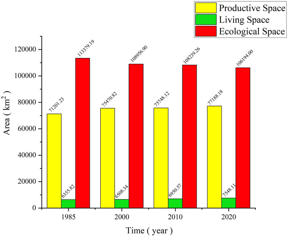
Changes in the territorial spatial of the PLES in Jilin Province from 1985 to 2020.
3.2 Characterization of territorial spatial type transfer in Jilin Province
The spatial transfer characteristics of Jilin Province are as follows (Figure 7): From 1985 to 2000, APL was mainly transferred out to GEL. OPL, living land, and WoEL were mainly transferred out to APL. GEL was mainly transferred out to OEL. WaEL and OEL were mainly transferred out to GEL. In terms of transfers in, the main transformation of territorial spatial goes to GEL and WaEL. From 2000 to 2010, APL and GEL were mainly transformed into WoEL. OPL was mainly transferred to APL. Living land and WoEL are mainly transferred out to APL, and WaEL is mainly transferred out to OEL. OEL is mainly transferred out to GEL. In terms of transfers in, the main transformation of territorial spatial goes to APL and WoEL. From 2010 to 2020, APL was mainly transferred to WoEL. OPL is mainly transferred to ULL. Living land, GEL, WoEL, and WaEL are mainly transferred to APL. OEL is mainly transferred to WaEL. In terms of transfer in, the main transformation of territorial spatial goes to APL and WaEL.

Territorial spatial transfer matrix in Jilin Province from 1985 to 2000.
3.3 Analysis of the evolution of the spatial center of gravity of Jilin Province
Taking the spatial location of the study area as the specific research object, the evolution of its center of gravity is analyzed, so as to derive the dynamic process of the spatio-temporal evolution of the territorial spatial within the scope of the study area and to further explore the characteristics of the evolution of the territorial spatial pattern in Jilin Province. From 1985 to 2020, the PS was mainly located in Changchun city (Figure 8). The change of PS is relatively gentle, with small span characteristics and no cross-administrative division, which indicates that the change characteristics of PS in Jilin Province are not obvious and mainly concentrated in Changchun City. Around 2000, it shifted to the northwest, indicating that the northwestern part of the core area of urban agglomeration in Jilin Province developed relatively slowly and occupied less arable land resources, so the center of gravity of PS shifted southward. The location of the center of gravity of LS in 1985–2020 was located in Changchun City, with a fluctuation occurring in 2000. The overall trend of the center of gravity gradually shifted southward and moved more obviously. It indicates that the characteristics of the LS in the southern region of Changchun were more drastic than those in the northern region in 2000. From 2000–2010, the center of gravity shifted northward and fluctuated less afterward. From 1985 to 2020, the center of gravity of ES in Jilin Province first moved to the northwest and then gradually shifted to the southeast, and the movement was more drastic after 2000. This indicates that the intensity of change in the southeast region of ES is more pronounced than in the northwest region, and the degree of concentration is greater. The center of gravity of ES gradually shifted from Changchun City to Jilin City, indicating that the core area of Jilin City rapidly developed ES, changed at a faster rate, and occupied more ecological resources, so the center of gravity of ES shifted southward.

Changes in the territorial spatial center of gravity of Jilin Province from 1985 to 2020.
3.4 Analysis of multi-scenario simulation results of Jilin Province territorial spatial
Under the natural development scenario (Figure 9), the spatial utilization structure of Jilin Province in 2030 is less modified. The western part of Jilin Province is still mainly arable land, and ULL is mainly concentrated in the Changchun City area. WoEL and GEL are mainly concentrated in the Changbai Mountain area in eastern Jilin Province, and WaEL is mainly in rivers, lakes, and reservoirs in the territory, etc. OEL pattern change trend is the same as that of 2010–2020. The overall change of territorial spatial is that APL, OPL, ULL, and RLL are all increasing, while the area of WoEL, GEL, WaEL, and OEL are all decreasing, with the most drastic change of WoEL.

Simulation prediction of territorial spatial utilization in Jilin Province in 2030. (a) 2030 NDS, (b) 2030 EPS, and (c) 2030 EDS.
Under the ecological protection scenario, the ES is strongly guaranteed. ULL and RLL still maintain the growth trend, but the increase is slowed down compared with the natural development scenario. OPL basically remains unchanged, and GEL, WaEL, and OEL show a decreasing trend. APL gradually increases. Under this scenario, OEL is decreasing, the ecological environment is effectively restored, the expansion of land for construction is to be slowed down, and WoEL is increasing.
Under the economic development scenario, the WoEL and GEL are basically flat and unchanged or slightly reduced, and the WaEL is relatively reduced. In the economic progress model, the transformation amount of construction land that constrains OPL, ULL, and RLL is added to the simulation of future development trends. The basic agricultural land reserve is established to strengthen the stability and structure of APL, so that the transformation of the rest of the territorial spatial use types avoids the basic APL reserve, and OEL is reduced accordingly. Woodland Ecosystems and grassland ecosystems have been reduced.
3.5 Hotspot analysis of three simulation scenarios for Jilin Province territorial spatial
By conducting hotspot analysis based on the dynamic attitude of the spatial area of Jilin Province from 2020 to 2030, the hotspots of their changes were obtained and studied (Figure 10) as follows.

Hotspot analysis of three scenarios of territorial spatial area movement attitudes in Jilin province. (a) NDS, (b) EPS, and (c) EDS.
Under the natural development scenario, the areas with large area fluctuations are mainly located in the northern part of Songyuan City, the central part of Jilin City, and the northern part of Changchun City, while the rest of the areas show a fragmented distribution. Under the ecological protection scenario, the changes are obvious in the western part of Jilin Province, especially in Changchun City, Songyuan City, and the northwestern part of Baicheng City, while the changes are more moderate in the eastern part of Jilin Province and Changbai Mountain area. While Jilin Province vigorously protects ES, the area of western Jilin Province undergoes large fluctuations, reflecting the more prominent changes in the area of the ecological environment in the region. Under the economic development scenario, the hotspot areas are mainly concentrated in western Jilin Province, with more drastic changes in Songyuan City, Changchun City, and the northwestern part of Baisheng City, and more concentrated changes in Siping City. The fluctuation of the spatial area of the country in western Jilin Province is more obvious.
In general, changes in the type of territorial spatial use under the natural development scenario, ecological protection scenario, and economic development scenario are simulated according to different scenario settings, resulting in different degrees of regulatory effects. Due to the continuous expansion of ULL and OPL in Jilin Province, there are cases of encroachment on the types of territorial spatial use such as GEL, APL, and WaEL, which is not conducive to the sustainable development of other land spaces and causes problems such as unbalanced development in some regions. And the unreasonable development of land space has caused certain harm to the ecological environment. In the future, attention should be paid to transforming the unreasonable land use in Jilin Province, improving its reasonable utilization rate, and promoting the sustainable development of territorial spatial.
4 Discussion and conclusion
4.1 Discussion
In this article, a multi-scenario simulation of the future territorial spatial pattern evolution of Jilin Province is carried out by the FLUS model. Although this work takes into account the principles of driver selection and can be expressed spatially when selecting the driving factors as the base file for FLUS model operation. However, in real life, some national policy factors, technological development progress, and national quality improvement are difficult to express spatially, and the data are difficult to quantify, thus limiting the selection of driving factors and processing analysis. When setting the parameters of the FLUS model, it is necessary to determine the best simulation accuracy by constantly trying to experiment, which has a certain subjectivity and a certain influence on the FLUS simulation results. How to objectively determine the experimental parameters and make them more objective and perfect also needs more research and analysis. The process of territorial spatial evolution includes complex factors of national policy-making and economic development, etc. In setting up the scenarios in this article, the enactment and implementation of these policies have had a significant impact on land use change in Jilin Province. However, due to the complexity and regionality of the policies, it is not possible to consider the impact of each policy on land use changes in a comprehensive way in scenario simulation settings. It is not possible to accurately predict future policy changes and formulation in China, and the border areas are affected by the economic development and policies and regulations of the neighboring countries. Therefore, in the scenario setting, only special areas such as ecological protection zones are restricted, and the development and changes of special areas such as economic development zones and border areas are not taken into account in a comprehensive way. In future research, we will continue to study how to solve this part of the shortcomings and improve the setting of the scenarios, so as to make the simulation results better.
Between 1985 and 2020, between China’s Seventh and Thirteenth Five-Year Plans, China’s economy grew rapidly, and the reform of its economic system liberated its productive forces. At the same time, China’s strategic decision to “open up land for agriculture in the Northeast” at the beginning of the country’s founding had a great impact on land use changes from 1985 to 2020. Since 2004, China’s strategy of “revitalizing the Northeast” has influenced spatial changes in production in Jilin Province. After the 1980s, China raised the implementation of family planning and population growth control to a high strategic level. Family planning is being established as a basic state policy, and measures to control population growth are becoming more stringent. However, as the population born in the early 1960s during the “second fertility peak” entered the childbearing age one after another, and as a result of the revision of the Marriage Law in the early 1980s, many of those who had not yet reached the age of late marriage entered marriage and childbearing earlier, the birth rate rebounded and the LS expanded. The period from 1992 to 2011 was the “sustainable development stage” of China’s ecological protection, during which the civilized development path of “productive development, affluent living, and ecological well-being” was proposed. In 2001, the State Environmental Protection Administration set up, on a pilot basis, ten national ecological protection zones, including the northern foothills of the Yinshan Mountains, the Horqin Sandy Land, the Sanjiang Plain, Poyang Lake, Dongting Lake, Ruoergai-Maqu, the Qinling Mountain Range, the Heihe River Basin, the source of the Yangtze River, the source of the Yellow River, and the Tarim River. Therefore, compared with the previous period, the decline of ES in Jilin Province slowed down from 2000 to 2010. In 2012, for the first time, China placed the construction of an ecological civilization on an equal footing with economic, political, cultural, and social construction. There has been a fundamental shift in the perception of ecological environmental protection, which has become a fundamental guideline for the whole society and an important driving force for optimizing and enhancing socio-economic development.
In this article, the characteristics of changes in the type of territorial spatial use in Jilin Province, the problems and the hotspot analysis of simulation results under different scenarios, and the fluctuating changes in the territorial spatial area of Jilin Province under the natural development scenario are dominated by the changes in the north of Songyuan City and the central part of Jilin City. With reference to scholars’ analysis of the dynamic evolution of the landscape pattern in Songyuan City [39], it is found that under the influence of economic development, a large number of native swampy wetlands and forests and some grasslands have been dramatically converted into arable land, and the number of patches has increased dramatically and the landscape fragmentation is serious. This is consistent with the trend of the results in this article that show large fluctuations in the spatial area of the territory of Songyuan City under the natural development scenario. This creates a central ring of a long ecological synergistic protection zone, an eastern high-functional ecological barrier zone, and a western important ecological restoration zone, consolidating the protection and restoration of Songnen wetlands and the western horqin wind and sand control.
Under the ecological protection scenario, Jilin Province is mainly characterized by large fluctuations in the spatial changes of the national land in Changchun City, Songyuan City, and the northwestern part of Baicheng City. Different ecological restoration and environmental remediation should be carried out for different areas, various compensation mechanisms should be explored, idle resource assets should be promoted, green industries should be cultivated and developed, ecological tourism should be developed, and green development complexes should be built.
The fluctuating changes in the spatial area of the national land in Jilin Province under the economic development scenario are characterized by significant changes in the western part of Jilin Province, including obvious degradation of ES, significant expansion of LS represented by urban building sites, and serious damage to the ecological environment. This leads to the emergence of many problems such as human–land–environment conflicts, unreasonable regional development and utilization, and coordinated development. Concerning the study on the evaluation of the value of ecosystem service function in the western part of Jilin Province [40], scholars have concluded that the degradation of wetlands and woodlands in the western region of Jilin Province is obvious. The increase of arable grassland and the increase of human activity intensity are the significant expansion of construction land and saline land; the destruction of the regional ecological environment is serious, which leads to the sharp decrease of wetlands and desertification, structural imbalance, and a series of problems exist, which coincides with the trend of the results of the hotspot analysis of spatial dynamics of Jilin Province under the economic development scenario in this article. It should be deeply integrated into the co-construction of the national northeast green economic belt, create ecological services, and build an ecological industrial system. At the same time, in the context of rapid economic development, constructing Changchun’s modern metropolitan area, radiation drives the synergistic development of neighboring cities. We will promote the adjustment and supervision of government land, improve the legal system of land, pay attention to the collaboration and linkage development of local areas, and determine the main direction of the future development of Jilin Province. Coordinate the balanced, stable, and reasonable development of territorial spatial, insist on improving the infrastructure of territorial spatial and resources, and promote the effective planning and development of territorial spatial resources to optimize the regional pattern and improve urban management.
Our research methods include exploring the law of evolution of spatio - temporal pattern of territorial spatial in Jilin Province from 2000 to 2020, selecting driving factors from multiple angles, levels, and directions, and predicting the evolution of territorial spatial in Jilin Province under different scenarios through FLUS model simulation. This article will provide effective references for the rational use of land resources, sustainable development of space, alleviation of human–land conflicts, and decision-making on the utilization of territorial spatial in Jilin Province. As well as providing a certain scientific basis for the delineation of the ecological protection red line in Jilin Province. It is a supplement to the theory and method of territorial spatial planning and a solution to the imbalance and insufficiency of spatial development and is of theoretical significance to the promotion of coordinated development of the PS, the LS, and the ES. At the same time, it provides a basis for the formulation of the spatial development and protection strategy by relevant government departments.
4.2 Conclusion
This article analyzes the characteristics of the change in territorial spatial utilization in Jilin Province from 1985 to 2020 in terms of the change in the quantity of territorial spatial utilization, the shift matrix, and the shift in the center of gravity. The FLUS model is used to simulate the spatial distribution pattern of territory under three different scenarios in 2030 and to compare and analyze the changes in territorial spatial use under different scenarios in the future, and the following conclusions are drawn:
The territorial spatial of Jilin Province is dominated by APL and forest ecosystems. From 1985 to 2020, the ES, dominated by woodlands, grasslands, watersheds, and unutilized land showed varying degrees of decrease, while the PS, dominated by arable land, and living land, dominated by building land, increased to a small extent. In terms of the magnitude of change, the PS and the LS increase to different degrees, while the ES decreases, reflecting the expansion of LS mainly construction land, which occupies a large amount of ES. The increasingly prominent contradiction between humans and land in Jilin Province during this period.
By studying the spatial shift matrix of the country, it is found that from 1985 to 2000, a large area of ULL was converted to APL. While from 2000 to 2010 and from 2010 to 2020, the WaEL and OEL were shifted to each other with large fluctuations. The analysis of the evolution of the center of gravity shows that the overall change of PS and LS in Jilin Province from 1985 to 2020 is relatively gentle, with small regional spanning characteristics, not obvious overall, and mainly concentrated in Changchun City. The ecospatial center of gravity moves more drastically, first moving northwest and then gradually shifting to the southeast, with a greater degree of agglomeration.
The future spatial distribution of territory in Jilin Province is obtained through different scenarios, and it can be seen that the spatial structure of land use in 2030 will not change much under the natural development scenario. Under the ecological protection scenario, the living land is still increasing, but the increase slows down compared to the natural development scenario. Under the economic development scenario, the ecological land use is basically the same or decreases to a small extent, while the stability and structure of the productive land use are enhanced. The hotspot analysis shows that under the natural development scenario, the fluctuation of the territorial spatial area is mainly in the northern part of Songyuan City, central Jilin City, and the northern part of Changchun City. Under the ecological protection scenario, the area of Changchun City, Songyuan City, and the northwestern part of Baicheng City fluctuates significantly, while the changes in the eastern part of Jilin Province and the Changbai Mountain area are more moderate. Under the economic development scenario, the hotspots of territorial spatial change are mainly in the western part of Jilin Province. The three simulation scenarios have certain reference significance for the orderly development of territorial spatial in Jilin Province and promote the sustainable development of the region.
-
Funding information: This work was support by the project of Jilin Provincial Science and Technology Department (20230508029RC) and the Natural Science Foundation of China project (41801165).
-
Author contributions: J.L. and D.S. designed the research; X.L. and D.W. performed the research and analyzed the data; J.J. and B.C. collated data; D.S. and X.L. wrote the article.
-
Conflict of interest: The authors declare that they have no known competing financial interests or personal relationships that could have appeared to influence the work reported in this article.
-
Data availability statement: Data will be made available on request.
References
[1] Xiao JC, Liu BK. Study on the formation mechanism of territorial spatial development pattern. Reg Econo Rev. 2013;(1):53–7. 10.14017/j.cnki.2095-5766.2013.01.025.Suche in Google Scholar
[2] Tu XQ, Fu C, Huang A, Chen HL, Ding X. DBSCAN spatial clustering analysis of urban “Production-Living-Ecological” space based on POI data: a case study of central urban Wuhan, China. Int J Environ Res Public Health. 2022;19(9):5153. 10.3390/IJERPH19095153.Suche in Google Scholar PubMed PubMed Central
[3] Song YY, Xue DQ, Xia SY, Mi BW. Change characteristics and formation mechanism of the territorial spatial pattern in the Yellow River Basin from 1980 to 2018, China. Geogr Res. 2021;40(5):1445–63. 10.11821/dlyj020191065.Suche in Google Scholar
[4] Huang JC, Lin HX, Qi XX. A literature review onoptimization of spatial development pattern based on ecological-production-living space. Prog Geogr. 2017;36(3):378–91. 10.18306/dlkxjz.2017.03.014.Suche in Google Scholar
[5] Lai Y, Huang GQ, Chen SZ, Lin ST, Lin WJ, Lyu JX. Land use dynamics and optimization from 2000 to 2020 in East Guangdong Province, China. Sustainability. 2021;13:3473. 10.3390/SU13063473.Suche in Google Scholar
[6] Liang XW, Zhang Y. Characteristics of the evolution of spatial and temporal patterns of spatial coupling and coordination of ecological-production-living space in rural Shandong province. JiangSu Agric Sci. 2021;49(1):20–7. 10.15889/j.issn.1002-1302.2021.01.004.Suche in Google Scholar
[7] Yang YY, Bao WK, Liu YS. Coupling coordination analysis of rural production-living-ecological space in the Beijing-Tianjin-Hebei region. Ecol Indic. 2020;117:106512. 10.1016/j.ecolind.2020.106512.Suche in Google Scholar
[8] Li XB. A review of the International researches on land use/land cover change. Acta Geogr Sin. 1996;(6):553–8.Suche in Google Scholar
[9] Sanchayeeta A, Jane S. Simulating forest cover changes of Bannerghatta National Park based on a CA-Markov model: a remote sensing approach. Remote Sens. 2012;4(10):3215–43. 10.3390/rs4103215.Suche in Google Scholar
[10] Zhao M, Cao YE, He ZF, He HT, Jiang YL. Evolution and optimization of three-generation function in Aksu area based on multi-scale fusion method. Territory Nat Resour Study. 2023;205(4):29–36. 10.16202/j.cnki.tnrs.2023.04.008.Suche in Google Scholar
[11] Dang LJ, Xu Y, Gao Y. Assessment method of functional land use classification and spatial system-A case study of Yangou Watershed. Res Soil Water Conserv. 2014;21(5):193–7. 10.13869/j.cnki.rswc.2014.05.034.Suche in Google Scholar
[12] Wang J, Sun Q, Zou L. Spatial-temporal evolution and driving mechanism of rural production-living-ecological space in Pingtan islands, China. Habitat Int. 2023;137:102833. 10.1016/J.HABITATINT.2023.102833.Suche in Google Scholar
[13] Li X, Wang YH, Wu KN, Feng Z. Analysis and prediction of carbon balance in production-living-ecological space of Henan Province, China. Environ Sci Pollut Res Int. 2023;30(30):75973–88. 10.1007/S11356-023-27705-8.Suche in Google Scholar
[14] Cui JX, Gu J, Sun JW, Luo J. The spatial and evolution characteristics of the production, living and ecological space in Hubei Province. China Land Sci. 2018;32(8):67–73. 10.11994/zgtdkx.20180723.121720.Suche in Google Scholar
[15] Huang XJ, Chen Y, Zhao YT, Shi MQ, Li TS. Optimization on land spatial development pattern in the Yellow River Basin: From the perspective of land development intensity. Geogr Res. 2021;40(6):1554–64. 10.11821/dlyj020200546.Suche in Google Scholar
[16] Wang ZF, Zhao SS. Research on spatial consistency between tourism resource environmental carrying capacity and land space function of urban agglomeration in the middle reaches of the Yangtze River. Resour Environ Yangtze Basin. 2021;30(5):1027–39. 10.11870/cjlyzyyhj202105001.Suche in Google Scholar
[17] Zhao BX, Li SJ, Liu ZS. Multi-scenario simulation and prediction of regional habitat quality based on a system dynamic and patch-generating land-use simulation coupling model – A case study of Jilin Province. Sustainability. 2022;14(9):5303. 10.3390/su14095303.Suche in Google Scholar
[18] Ran YJ. Research on simulation and prediction of land use change in Banan District based on CA-Markov model. Anhui Agri Sci Bull. 2021;27(11):125–30. 10.16377/j.cnki.issn1007-7731.2021.11.046.Suche in Google Scholar
[19] Wang XR, Pan PP, Wang XX, Wang XM. Simulation and landscape pattern for land use in Hebei province based on GeoSOS-FLUS model. Jiangsu J Agr Sci. 2021;37(3):667–75. 10.3969/j.issn.1000-4440.2021.03.015.Suche in Google Scholar
[20] Jiao GY, Yang XZ, Huang ZQ, Zhang X, Lu L. Evolution characteristics and possible impact factors for the changing pattern and function of “Production-Living-Ecological” space in Wuyuan country. J Nat Resour. 2021;36(5):1252–67. 10.31497/zrzyxb.20210513.Suche in Google Scholar
[21] Su YQ, Liu G, Zhao JB, Niu JJ, Zhang EY, Guo LG, et al. Multi-scenario simulation prediction of ecological space in the Fenhe River Basin using the FLUS model. Arid Zone Res. 2021;38(4):1152–61. 10.13866/j.azr.2021.04.27.Suche in Google Scholar
[22] Liu JF, Lin YL, Zhao JS. Countryland use change simulation and expansion analysis based on FLUS model. Urban Geotech Invest Surv. 2022;(2):16–21.Suche in Google Scholar
[23] Lin YL, Zhao JS, Chen GP, Zhang M. Optimization of regional territory space pattern based on MCR-FLUS-Markov model. Trans Chin Soc Agric Mach. 2021;52(4):159–70+207. 10.6041/j.issn.1000-1298.2021.04.017.Suche in Google Scholar
[24] Sun DZ, Liang YJ. Multi-scenario simulation of land use dynamic in the Loess Plateau using an improved Markov-CA model. J Geoda-Inf Sci. 2021;23(5):825–36.Suche in Google Scholar
[25] Zhu ZQ, Ma XS, Hu H. Spatio-temporal evolution and prediction of ecosystem carbon stocks in Guangzhou City by coupling FLUS-InVEST models. Bull Soil Water Conserv. 2021;41(2):222–9+239. 10.13961/j.cnki.stbctb.2021.02.030.Suche in Google Scholar
[26] Liang X, Liu XP, Li X, Chen YM, Tian H, Yao Y. Delineating multi-scenario urban growth boundaries with a CA-based FLUS model and morphological method. Landsc Urban Plan. 2018;177:47–63.10.1016/j.landurbplan.2018.04.016Suche in Google Scholar
[27] Ma BW, Wang X. What is the future of ecological space in Wuhan Metropolitan Area? A multi-scenario simulation based on Markov-FLUS. Ecol Indic. 2022;147:109124. 10.1016/J.ECOLIND.2022.109124.Suche in Google Scholar
[28] Zhang XR, Li AN, Nan X, Lei GB, Wang CB. Multi-scenario simulation of land use change along China-Pakistan Economic Corridor through coupling FLUS model with SD model. J Geoda-Inf Sci. 2020;22(12):2393–409.Suche in Google Scholar
[29] Xia CH, Zhai GF. Territorial spatial vulnerability assessment based on PSO-BP neural network: A case study in Shenzhen, China. Ecol Inform. 2023;75:102088. 10.1016/J.ECOINF.2023.102088.Suche in Google Scholar
[30] Wang XL, Liu Y, Zhang Y, Liu JP. Exploration and prediction of land use/cover change in western Jilin province based on Ca-markov model. Sci Technol Eng. 2021;21(19):7942–8.Suche in Google Scholar
[31] Lin WQ, Liu L, Wu NW, Zhou YH, Chen HY, Li SH. Application of the cellular automata model in the territory spatial planning on the perspective of Basin: A case study of Henan Province Yellow River Basin territory spatial planning. Shanghai City Plan. 2021;(3):34–41.Suche in Google Scholar
[32] Feng YK, Zhai SY, Jiang XT, Luo JJ, Yan PX, Dong CC, et al. Simulating spatio-temporal pattern of production-living-ecological space and evaluating eco-environmental effects in Zhongyuan Urban Agglomeration based on FLUS model and shared socioeconomic pathways. Acta Ecol Sin. 2023;40(30):8292–308. 10.20103/j.stxb.202210192970.Suche in Google Scholar
[33] Wang MC, Guo X, Wang FY, Zhang XY. Dynamic change and predictive analysis of land use types in Changchun City based on FLUS model. J Jilin Univ (Earth Sci Ed). 2019;49(6):1795–804. 10.13278/j.cnki.jjuese.20180312.Suche in Google Scholar
[34] Jiang ZP, Bao AM, Li YH. Scenario simulation analysis of Urumqi urban sprawl based on GeoSOS-FLUS model. Remote Sens Technol Appl. 2023;38(2):332–40.Suche in Google Scholar
[35] Wan DJ, Liu JP, Zhao DD. Assessment of carbon storage under different SSP-RCP scenarios in terrestrial ecosystems of Jilin Province, China. Int J Environ Res Public Health. 2023;20(4):3691. 10.3390/IJERPH20043691.Suche in Google Scholar
[36] Fu JC, Zhang SL. Functional assessment and coordination characteristics of production, living, ecological function – a case study of Henan Province, China. Int J Environ Res Public Health. 2021;18(15):8051. 10.3390/IJERPH18158051.Suche in Google Scholar PubMed PubMed Central
[37] Liu JL, Liu YS, Li YR. Classification evaluation and spatial-temporal analysis of”production-living-ecological” spaces in China. Acta Geogr Sin. 2017;72(7):1290–304.Suche in Google Scholar
[38] Li H, Song Y, Zhang M. Study on the gravity center evolution of air pollution in Yangtze River Delta of China. Nat Hazards. 2018;90(3):1447–59.10.1007/s11069-017-3110-1Suche in Google Scholar
[39] Zhang ZH, Yang YC, Xie P, Zhao SS, Lin SJ, Bao GD, et al. Dynamic variation of landscape pattern of land use in Songyuan City in Nearly 20 Years. Chin Agric Sci Bull. 2014;30(2):222–6. 10.1007/s11069-017-3110-1.Suche in Google Scholar
[40] Yi S, Wang DY, Liu SH, Li H. Spatial-temporal variation and mechanisms causing spatial differentiation of ecosystem services in ecologically fragile regions based on value evaluation: a case study of Western Jilin, China. Land. 2021;18(15):8051. 10.3390/LAND11050629.Suche in Google Scholar
© 2024 the author(s), published by De Gruyter
This work is licensed under the Creative Commons Attribution 4.0 International License.
Artikel in diesem Heft
- Regular Articles
- Theoretical magnetotelluric response of stratiform earth consisting of alternative homogeneous and transitional layers
- The research of common drought indexes for the application to the drought monitoring in the region of Jin Sha river
- Evolutionary game analysis of government, businesses, and consumers in high-standard farmland low-carbon construction
- On the use of low-frequency passive seismic as a direct hydrocarbon indicator: A case study at Banyubang oil field, Indonesia
- Water transportation planning in connection with extreme weather conditions; case study – Port of Novi Sad, Serbia
- Zircon U–Pb ages of the Paleozoic volcaniclastic strata in the Junggar Basin, NW China
- Monitoring of mangrove forests vegetation based on optical versus microwave data: A case study western coast of Saudi Arabia
- Microfacies analysis of marine shale: A case study of the shales of the Wufeng–Longmaxi formation in the western Chongqing, Sichuan Basin, China
- Multisource remote sensing image fusion processing in plateau seismic region feature information extraction and application analysis – An example of the Menyuan Ms6.9 earthquake on January 8, 2022
- Identification of magnetic mineralogy and paleo-flow direction of the Miocene-quaternary volcanic products in the north of Lake Van, Eastern Turkey
- Impact of fully rotating steel casing bored pile on adjacent tunnels
- Adolescents’ consumption intentions toward leisure tourism in high-risk leisure environments in riverine areas
- Petrogenesis of Jurassic granitic rocks in South China Block: Implications for events related to subduction of Paleo-Pacific plate
- Differences in urban daytime and night block vitality based on mobile phone signaling data: A case study of Kunming’s urban district
- Random forest and artificial neural network-based tsunami forests classification using data fusion of Sentinel-2 and Airbus Vision-1 satellites: A case study of Garhi Chandan, Pakistan
- Integrated geophysical approach for detection and size-geometry characterization of a multiscale karst system in carbonate units, semiarid Brazil
- Spatial and temporal changes in ecosystem services value and analysis of driving factors in the Yangtze River Delta Region
- Deep fault sliding rates for Ka-Ping block of Xinjiang based on repeating earthquakes
- Improved deep learning segmentation of outdoor point clouds with different sampling strategies and using intensities
- Platform margin belt structure and sedimentation characteristics of Changxing Formation reefs on both sides of the Kaijiang-Liangping trough, eastern Sichuan Basin, China
- Enhancing attapulgite and cement-modified loess for effective landfill lining: A study on seepage prevention and Cu/Pb ion adsorption
- Flood risk assessment, a case study in an arid environment of Southeast Morocco
- Lower limits of physical properties and classification evaluation criteria of the tight reservoir in the Ahe Formation in the Dibei Area of the Kuqa depression
- Evaluation of Viaducts’ contribution to road network accessibility in the Yunnan–Guizhou area based on the node deletion method
- Permian tectonic switch of the southern Central Asian Orogenic Belt: Constraints from magmatism in the southern Alxa region, NW China
- Element geochemical differences in lower Cambrian black shales with hydrothermal sedimentation in the Yangtze block, South China
- Three-dimensional finite-memory quasi-Newton inversion of the magnetotelluric based on unstructured grids
- Obliquity-paced summer monsoon from the Shilou red clay section on the eastern Chinese Loess Plateau
- Classification and logging identification of reservoir space near the upper Ordovician pinch-out line in Tahe Oilfield
- Ultra-deep channel sand body target recognition method based on improved deep learning under UAV cluster
- New formula to determine flyrock distance on sedimentary rocks with low strength
- Assessing the ecological security of tourism in Northeast China
- Effective reservoir identification and sweet spot prediction in Chang 8 Member tight oil reservoirs in Huanjiang area, Ordos Basin
- Detecting heterogeneity of spatial accessibility to sports facilities for adolescents at fine scale: A case study in Changsha, China
- Effects of freeze–thaw cycles on soil nutrients by soft rock and sand remodeling
- Vibration prediction with a method based on the absorption property of blast-induced seismic waves: A case study
- A new look at the geodynamic development of the Ediacaran–early Cambrian forearc basalts of the Tannuola-Khamsara Island Arc (Central Asia, Russia): Conclusions from geological, geochemical, and Nd-isotope data
- Spatio-temporal analysis of the driving factors of urban land use expansion in China: A study of the Yangtze River Delta region
- Selection of Euler deconvolution solutions using the enhanced horizontal gradient and stable vertical differentiation
- Phase change of the Ordovician hydrocarbon in the Tarim Basin: A case study from the Halahatang–Shunbei area
- Using interpretative structure model and analytical network process for optimum site selection of airport locations in Delta Egypt
- Geochemistry of magnetite from Fe-skarn deposits along the central Loei Fold Belt, Thailand
- Functional typology of settlements in the Srem region, Serbia
- Hunger Games Search for the elucidation of gravity anomalies with application to geothermal energy investigations and volcanic activity studies
- Addressing incomplete tile phenomena in image tiling: Introducing the grid six-intersection model
- Evaluation and control model for resilience of water resource building system based on fuzzy comprehensive evaluation method and its application
- MIF and AHP methods for delineation of groundwater potential zones using remote sensing and GIS techniques in Tirunelveli, Tenkasi District, India
- New database for the estimation of dynamic coefficient of friction of snow
- Measuring urban growth dynamics: A study in Hue city, Vietnam
- Comparative models of support-vector machine, multilayer perceptron, and decision tree predication approaches for landslide susceptibility analysis
- Experimental study on the influence of clay content on the shear strength of silty soil and mechanism analysis
- Geosite assessment as a contribution to the sustainable development of Babušnica, Serbia
- Using fuzzy analytical hierarchy process for road transportation services management based on remote sensing and GIS technology
- Accumulation mechanism of multi-type unconventional oil and gas reservoirs in Northern China: Taking Hari Sag of the Yin’e Basin as an example
- TOC prediction of source rocks based on the convolutional neural network and logging curves – A case study of Pinghu Formation in Xihu Sag
- A method for fast detection of wind farms from remote sensing images using deep learning and geospatial analysis
- Spatial distribution and driving factors of karst rocky desertification in Southwest China based on GIS and geodetector
- Physicochemical and mineralogical composition studies of clays from Share and Tshonga areas, Northern Bida Basin, Nigeria: Implications for Geophagia
- Geochemical sedimentary records of eutrophication and environmental change in Chaohu Lake, East China
- Research progress of freeze–thaw rock using bibliometric analysis
- Mixed irrigation affects the composition and diversity of the soil bacterial community
- Examining the swelling potential of cohesive soils with high plasticity according to their index properties using GIS
- Geological genesis and identification of high-porosity and low-permeability sandstones in the Cretaceous Bashkirchik Formation, northern Tarim Basin
- Usability of PPGIS tools exemplified by geodiscussion – a tool for public participation in shaping public space
- Efficient development technology of Upper Paleozoic Lower Shihezi tight sandstone gas reservoir in northeastern Ordos Basin
- Assessment of soil resources of agricultural landscapes in Turkestan region of the Republic of Kazakhstan based on agrochemical indexes
- Evaluating the impact of DEM interpolation algorithms on relief index for soil resource management
- Petrogenetic relationship between plutonic and subvolcanic rocks in the Jurassic Shuikoushan complex, South China
- A novel workflow for shale lithology identification – A case study in the Gulong Depression, Songliao Basin, China
- Characteristics and main controlling factors of dolomite reservoirs in Fei-3 Member of Feixianguan Formation of Lower Triassic, Puguang area
- Impact of high-speed railway network on county-level accessibility and economic linkage in Jiangxi Province, China: A spatio-temporal data analysis
- Estimation model of wild fractional vegetation cover based on RGB vegetation index and its application
- Lithofacies, petrography, and geochemistry of the Lamphun oceanic plate stratigraphy: As a record of the subduction history of Paleo-Tethys in Chiang Mai-Chiang Rai Suture Zone of Thailand
- Structural features and tectonic activity of the Weihe Fault, central China
- Application of the wavelet transform and Hilbert–Huang transform in stratigraphic sequence division of Jurassic Shaximiao Formation in Southwest Sichuan Basin
- Structural detachment influences the shale gas preservation in the Wufeng-Longmaxi Formation, Northern Guizhou Province
- Distribution law of Chang 7 Member tight oil in the western Ordos Basin based on geological, logging and numerical simulation techniques
- Evaluation of alteration in the geothermal province west of Cappadocia, Türkiye: Mineralogical, petrographical, geochemical, and remote sensing data
- Numerical modeling of site response at large strains with simplified nonlinear models: Application to Lotung seismic array
- Quantitative characterization of granite failure intensity under dynamic disturbance from energy standpoint
- Characteristics of debris flow dynamics and prediction of the hazardous area in Bangou Village, Yanqing District, Beijing, China
- Rockfall mapping and susceptibility evaluation based on UAV high-resolution imagery and support vector machine method
- Statistical comparison analysis of different real-time kinematic methods for the development of photogrammetric products: CORS-RTK, CORS-RTK + PPK, RTK-DRTK2, and RTK + DRTK2 + GCP
- Hydrogeological mapping of fracture networks using earth observation data to improve rainfall–runoff modeling in arid mountains, Saudi Arabia
- Petrography and geochemistry of pegmatite and leucogranite of Ntega-Marangara area, Burundi, in relation to rare metal mineralisation
- Prediction of formation fracture pressure based on reinforcement learning and XGBoost
- Hazard zonation for potential earthquake-induced landslide in the eastern East Kunlun fault zone
- Monitoring water infiltration in multiple layers of sandstone coal mining model with cracks using ERT
- Study of the patterns of ice lake variation and the factors influencing these changes in the western Nyingchi area
- Productive conservation at the landslide prone area under the threat of rapid land cover changes
- Sedimentary processes and patterns in deposits corresponding to freshwater lake-facies of hyperpycnal flow – An experimental study based on flume depositional simulations
- Study on time-dependent injectability evaluation of mudstone considering the self-healing effect
- Detection of objects with diverse geometric shapes in GPR images using deep-learning methods
- Behavior of trace metals in sedimentary cores from marine and lacustrine environments in Algeria
- Spatiotemporal variation pattern and spatial coupling relationship between NDVI and LST in Mu Us Sandy Land
- Formation mechanism and oil-bearing properties of gravity flow sand body of Chang 63 sub-member of Yanchang Formation in Huaqing area, Ordos Basin
- Diagenesis of marine-continental transitional shale from the Upper Permian Longtan Formation in southern Sichuan Basin, China
- Vertical high-velocity structures and seismic activity in western Shandong Rise, China: Case study inspired by double-difference seismic tomography
- Spatial coupling relationship between metamorphic core complex and gold deposits: Constraints from geophysical electromagnetics
- Disparities in the geospatial allocation of public facilities from the perspective of living circles
- Research on spatial correlation structure of war heritage based on field theory. A case study of Jinzhai County, China
- Formation mechanisms of Qiaoba-Zhongdu Danxia landforms in southwestern Sichuan Province, China
- Magnetic data interpretation: Implication for structure and hydrocarbon potentiality at Delta Wadi Diit, Southeastern Egypt
- Deeply buried clastic rock diagenesis evolution mechanism of Dongdaohaizi sag in the center of Junggar fault basin, Northwest China
- Application of LS-RAPID to simulate the motion of two contrasting landslides triggered by earthquakes
- The new insight of tectonic setting in Sunda–Banda transition zone using tomography seismic. Case study: 7.1 M deep earthquake 29 August 2023
- The critical role of c and φ in ensuring stability: A study on rockfill dams
- Evidence of late quaternary activity of the Weining-Shuicheng Fault in Guizhou, China
- Extreme hydroclimatic events and response of vegetation in the eastern QTP since 10 ka
- Spatial–temporal effect of sea–land gradient on landscape pattern and ecological risk in the coastal zone: A case study of Dalian City
- Study on the influence mechanism of land use on carbon storage under multiple scenarios: A case study of Wenzhou
- A new method for identifying reservoir fluid properties based on well logging data: A case study from PL block of Bohai Bay Basin, North China
- Comparison between thermal models across the Middle Magdalena Valley, Eastern Cordillera, and Eastern Llanos basins in Colombia
- Mineralogical and elemental analysis of Kazakh coals from three mines: Preliminary insights from mode of occurrence to environmental impacts
- Chlorite-induced porosity evolution in multi-source tight sandstone reservoirs: A case study of the Shaximiao Formation in western Sichuan Basin
- Predicting stability factors for rotational failures in earth slopes and embankments using artificial intelligence techniques
- Origin of Late Cretaceous A-type granitoids in South China: Response to the rollback and retreat of the Paleo-Pacific plate
- Modification of dolomitization on reservoir spaces in reef–shoal complex: A case study of Permian Changxing Formation, Sichuan Basin, SW China
- Geological characteristics of the Daduhe gold belt, western Sichuan, China: Implications for exploration
- Rock physics model for deep coal-bed methane reservoir based on equivalent medium theory: A case study of Carboniferous-Permian in Eastern Ordos Basin
- Enhancing the total-field magnetic anomaly using the normalized source strength
- Shear wave velocity profiling of Riyadh City, Saudi Arabia, utilizing the multi-channel analysis of surface waves method
- Effect of coal facies on pore structure heterogeneity of coal measures: Quantitative characterization and comparative study
- Inversion method of organic matter content of different types of soils in black soil area based on hyperspectral indices
- Detection of seepage zones in artificial levees: A case study at the Körös River, Hungary
- Tight sandstone fluid detection technology based on multi-wave seismic data
- Characteristics and control techniques of soft rock tunnel lining cracks in high geo-stress environments: Case study of Wushaoling tunnel group
- Influence of pore structure characteristics on the Permian Shan-1 reservoir in Longdong, Southwest Ordos Basin, China
- Study on sedimentary model of Shanxi Formation – Lower Shihezi Formation in Da 17 well area of Daniudi gas field, Ordos Basin
- Multi-scenario territorial spatial simulation and dynamic changes: A case study of Jilin Province in China from 1985 to 2030
- Review Articles
- Major ascidian species with negative impacts on bivalve aquaculture: Current knowledge and future research aims
- Prediction and assessment of meteorological drought in southwest China using long short-term memory model
- Communication
- Essential questions in earth and geosciences according to large language models
- Erratum
- Erratum to “Random forest and artificial neural network-based tsunami forests classification using data fusion of Sentinel-2 and Airbus Vision-1 satellites: A case study of Garhi Chandan, Pakistan”
- Special Issue: Natural Resources and Environmental Risks: Towards a Sustainable Future - Part I
- Spatial-temporal and trend analysis of traffic accidents in AP Vojvodina (North Serbia)
- Exploring environmental awareness, knowledge, and safety: A comparative study among students in Montenegro and North Macedonia
- Determinants influencing tourists’ willingness to visit Türkiye – Impact of earthquake hazards on Serbian visitors’ preferences
- Application of remote sensing in monitoring land degradation: A case study of Stanari municipality (Bosnia and Herzegovina)
- Optimizing agricultural land use: A GIS-based assessment of suitability in the Sana River Basin, Bosnia and Herzegovina
- Assessing risk-prone areas in the Kratovska Reka catchment (North Macedonia) by integrating advanced geospatial analytics and flash flood potential index
- Analysis of the intensity of erosive processes and state of vegetation cover in the zone of influence of the Kolubara Mining Basin
- GIS-based spatial modeling of landslide susceptibility using BWM-LSI: A case study – city of Smederevo (Serbia)
- Geospatial modeling of wildfire susceptibility on a national scale in Montenegro: A comparative evaluation of F-AHP and FR methodologies
- Geosite assessment as the first step for the development of canyoning activities in North Montenegro
- Urban geoheritage and degradation risk assessment of the Sokograd fortress (Sokobanja, Eastern Serbia)
- Multi-hazard modeling of erosion and landslide susceptibility at the national scale in the example of North Macedonia
- Understanding seismic hazard resilience in Montenegro: A qualitative analysis of community preparedness and response capabilities
- Forest soil CO2 emission in Quercus robur level II monitoring site
- Characterization of glomalin proteins in soil: A potential indicator of erosion intensity
- Power of Terroir: Case study of Grašac at the Fruška Gora wine region (North Serbia)
- Special Issue: Geospatial and Environmental Dynamics - Part I
- Qualitative insights into cultural heritage protection in Serbia: Addressing legal and institutional gaps for disaster risk resilience