The new insight of tectonic setting in Sunda–Banda transition zone using tomography seismic. Case study: 7.1 M deep earthquake 29 August 2023
-
 ,
,

Abstract
The Sunda–Banda arc transition zone features the collision of the Indo-Australian oceanic plate and the Australian continent, resulting in intricate geological and geodynamic conditions. Tectonic activity in this region is shaped by the convergence of multiple major plates, including the Indo-Australian oceanic plate and the Eurasian plate. The crustal structure along the Sunda–Banda arc transition zone is complex and influenced by various factors such as subduction, continental collision, and volcanic activity. The tectonic complexity of the region in eastern Indonesia makes it an interesting area for study. In this research, International Seismological Centre-Engdahl-van der Hilst-Buland catalogue data from 1964 to 2020 were used, which include recorded information on 69.705 earthquake events from 1.185 recording stations and consist of 2.943.974 P phases. Resolution testing was performed using various velocity grids, and optimal results were obtained with a medium resolution of ∼100 km × 100 km × 80 km for the inversion process. The tomographic inversion analysis provided valuable insights into subsurface structures within Earth’s crust and mantle up to a depth of approximately 750 km. The occurrence of deep earthquakes in the study area has provided valuable insights into complex dynamics associated with subduction and plate tectonics. The results of the tomographic inversion analysis reveal that earthquakes are concentrated in areas with high-velocity anomalies, indicating intense tectonic activity near the subduction zone. This study offers the perspective on the structural complexities and earthquake origins in the Sunda–Banda arc transition zone following the 2023 Mw 7.1 Bali Sea earthquake, which occurred on August 29, 2023, at 02:55:32 UTC + 7, approximately 163 km northeast of Lombok, Indonesia. This earthquake was caused by slab pull activity from the Australian Plate and involved a combination of downward and oblique-normal movement. These characteristics indicate the convergence and interaction between tectonic plates in the subduction process occurring in the Bali Sea area. As a result, there have been frequent occurrences of various tectonic and volcanic activities including earthquakes of different magnitudes. These results highlight the significance of the high-velocity anomaly connected to this occurrence, offering valuable insights into seismic behaviour and tectonic phenomena in the region. The findings of this study indicate that the deep earthquakes in the Bali Sea may be induced by faulting due to the transformation of metastable olivine into denser spinel at significant depths, along with shear instability caused by phase transitions within Earth’s mantle layers. This theory proposes that stress-induced changes in phase can initiate shear instabilities and subsequently lead to deep earthquakes.
1 Introduction
The interaction between the Indo-Australian and Eurasian plates has resulted in active faults and geological formations in Bali and its surrounding areas, including a sea trench and an outer arc basin. These features are commonly found in subduction zones where one plate sinks beneath another into the earth’s mantle. Subduction zones are critical on a global scale because they drive plate movement through sinking slabs into the mantle. They also contribute to volcanic eruptions, megathrust earthquakes, and valuable mineral resources [1,2,3]. The subduction process between the Indo-Australian and Eurasian plates primarily influences the tectonic activity in Bali and its neighbouring areas [4]. The study delves into the seismic event in the Lesser Sunda Islands, primarily triggered by the collision of the Australian and Eurasian plates. The tsunami hazard map shows the impact of tsunamis on Bali’s southern coastline, but it fails to consider potential dangers from back arc faults, subsurface landslides, and volcanic activity [5,6,7]. These deep earthquakes result from plastic shear instabilities and shear-induced melting with temperature dependencies. Understanding these geological processes and plate interactions is critical for accurately analysing and predicting seismic activity in the region. Overall, the tectonic activity in Bali and its neighbouring areas, influenced by the subduction process between the Indo-Australian and Eurasian plates, plays a significant role in shaping the seismicity and volcanic activity in the region [8,9]. The movement of the Eurasian, Indo-Australian, and Pacific plates in eastern Indonesia led to the formation of the Banda Seram segment. Additionally, seismic tomography modelling offers valuable insights into the internal structure of Earth beneath the Sunda–Banda arc transition zone [10].
Tectonic plate movement, specifically the subduction process between the Eurasian and Indo-Australian Ocean Plates, triggers seismic events in the region at a rate of 7 cm per year. The primary cause of the south Bali earthquakes is the collision between the Australia and Eurasia plates, which leads to tectonic activity. The Australia Plate is undergoing subduction beneath the Eurasia Plate at a velocity of 6.7 ± 7 millimetres per year in the N11°E ± 4° direction. The Sunda Shelf block is presently undergoing southeastward movement in relation to Eurasia, with an approximate rate of 6 ± 3 mm/year [11,12,13,14,15,16,17].
The Timor–Banda Sea region has a history of significant earthquakes. These events, occurring in 1982, 1996, and 2000, have caused varying degrees of damage and affected multiple regions. On June 22, 1982, there was a magnitude 6.8 earthquake at a depth of 450 km (Figure 1). Another earthquake with a magnitude of 6.6 occurred at a depth of 515 km (Figure 1). This event impacted various regions, including Timor, Bali, Maluku, and the Banda Sea area itself. Additionally, on June 17, 1996, an earthquake measuring approximately M 7.7 (Figure 1) struck the Larantuka and Maumere areas, resulting in damage to the Flores Sea as well as Kupang while causing minor damage elsewhere in Kupang [18]. In recent years, the Banda Sea area has experienced significant seismic activity. On August 28, 2000, a notable earthquake with a magnitude of approximately M 6.5 occurred at a depth of 684 km (Figure 1). The M 7.1 earthquake, located northeast of North Lombok, followed this on August 29. These events have caused damage to various regions, highlighting the need for continued monitoring and study of tectonic activity in this area to ensure community safety and hazard mitigation.
![Figure 1
From 1982 to 2023, deep earthquakes with a magnitude ≥6.5 along the subduction zone in eastern Indonesia were distributed [19,20].](/document/doi/10.1515/geo-2022-0710/asset/graphic/j_geo-2022-0710_fig_001.jpg)
Bali, as one of Indonesia’s most commercially valued tourism destinations, has experienced earthquakes at rates of up to 150 each year since 2019. The tectonic activity or volcanic activity of nearby volcanoes can be the source of earthquakes in this region. The seismic activity at Mount Agung in Bali caused significant agitation, monitoring, emergency management, evacuation, and volcanic eruption. Seismic data and historical volcanic event comparisons were major sources of information for early eruption projections. Additional monitoring streams aided in short-term forecasting attempts while the crisis persisted [21,22]. The inversion of long-period P and SH waves, with centroidal depths ranging from 10 to 18 km and uncertainties from 7 to 24 km, identifies deep earthquakes in the Bali Sea. P wave nodal planes dip south at 13° to 35°, indicating crust thrusting beneath the Bali Basin [23]. The recurrence of deadly earthquakes in Bali during the past 5 years serves as a sharp reminder of the island’s seismic vulnerability. Bali residents have faced enormous challenges in dealing with natural disasters, ranging from the catastrophic 6.4 magnitude earthquake in 2018, which claimed more than 20 lives, to the subsequent series of earthquakes in 2019, which caused extensive damage to infrastructure. The frequency and size of these earthquakes have also raised concerns about the region’s preparedness for future seismic activity. Building infrastructure and preparing for future disasters are needed as Bali recovers from recent natural disasters. It is essential to conduct research on the origins of seismic activity in the Bali region, given the increasing frequency of earthquakes documented between 2018 and 2023.
This research used inversion tomography to analyse a data set from 1964 to 2020 – this method is used in seismology to create 3D models of subsurface structures by inverting seismic travel time data. Using inversion with fast marching tomography (FMTOMO), we are able to better constrain the velocity structure of the Earth’s interior, which allows us to gain a clearer understanding of earthquake processes and the dynamics of tectonic plates. This information is crucial for studying seismic hazards and improving our ability to predict and mitigate the impacts of earthquakes. For example, in a study of a seismically active region, researchers may use FMTOMO inversion to create detailed 3D models of the subsurface to identify fault lines and potential earthquake risk zones. This information can then be used by policymakers and urban planners to improve building codes and emergency response plans in order to better protect communities from seismic events. The study specifically focuses on examining velocity structures and their impact on the underlying region. Furthermore, by studying the effects of an M 7.1 earthquake that took place in the Bali Sea in 2023, this research offers valuable insights into understanding subduction zone dynamics and enhancing our ability to mitigate earthquake risks in future.
2 Data and method
2.1 Data
We collected P wave arrival-time data of earthquakes from the International Seismological Centre-EHB Bulletins from 1964 to 2020 (Figure 2). Our dataset includes 2.943.974 arrival times of P waves from 69.705 earthquakes recorded by 1.185 seismic stations in the study region. All of the selected events were located within the study region and recorded at more than ten seismic stations. The residuals for P wave travel times varied widely, with a cut-off residual of ±3 s. We used the AK135 velocity model [24] as the initial velocity model in tomographic inversion.
![Figure 2
Distribution map of earthquake epicentre locations collected from the International Seismological Centre-Engdahl-van der Hilst-Buland Bulletins during 1964–2020 [18,19] in eastern Indonesia and earthquake-recording stations.](/document/doi/10.1515/geo-2022-0710/asset/graphic/j_geo-2022-0710_fig_002.jpg)
3 Method
The Fast-Marching Method (FMM) is an efficient method for solving Eikonal equations when Fx is not low. It allows for the accurate and robust modelling of seismic wave propagation. In addition, FMM can be utilized in the inversion of passive seismic methods to determine the hypocentre location [25]. The formulation of the Eikonal equation is as follows:
where Fx is a function of velocity and x is the arrival time of the wave at point 0. The equation for the first order for 3D fast marching to calculate the arrival time of the wave:
The FMM operates by forming a solution in the shortest possible time. The FMTOMO package employed repeated non-linear inversion tomography to account for variations in Vp and Vs [26,27,28,29]. FMTOMO uses the FMM method, a grid-based Eikonal, to advance travel time prediction. The main advantage of this method is that it can produce reliable travel time predictions in areas that have a very heterogeneous velocity structure [30]. In this inversion calculation, the first step is forward modelling to calculate travel time predictions for the dataset used. FMTOMO uses the fast-marching ray tracing method, which is a grid-based numerical method with a finite-difference algorithm. The FMTOMO program [28] employs a subspace inversion method to solve the inversion equation. Subspace inversion is a gradient-based technique and therefore requires Fréchet derivatives. The objective function that invert3d minimizes in order to solve the inverse problem has the form:
where
and object functions associated with the initials of the model
and the stratigraphic variation function is as follows:
where gm is the calculation residual, d
obs is the observation residual, and C
d is the covariance data matrix, while m is the model parameter,
In this study, the process of tomographic inversion began with data preparation, which involved identifying the earthquake source and stations within the Banda arc region. We performed grid parameterization to establish the area for tomographic inversion calculations. For the velocity and propagation grid, we use ∼100 km × 100 km × 80 km. This process also establishes the initial velocity model for the tomography iteration process. We take the initial velocity model from the 1D AK135 velocity model Supplementary S1 [24].
4 Result and discussion
The inversion result has good ray coverage up to 750 km (Figure 3). We constructed a vertical section in the west–east and south–north directions based on the results of previous studies and the resolution test.
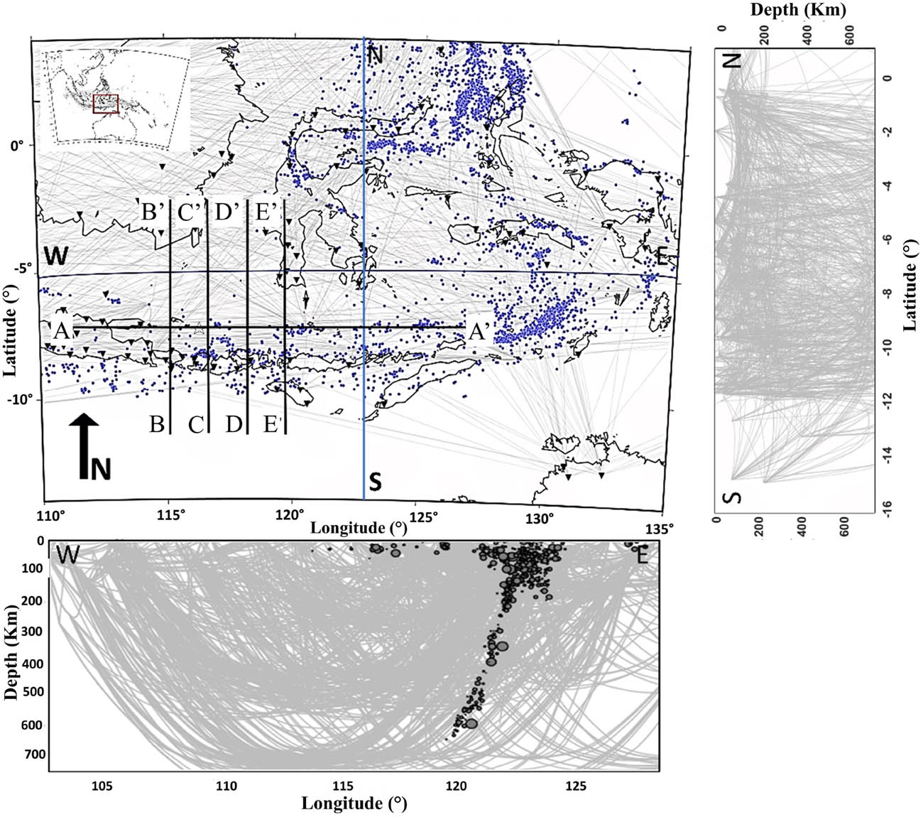
Ray path coverage includes horizontal and vertical cross-sections. Grey represents the ray tracing, blue dots represent the earthquake events, and a black reverse triangle represents an earthquake-recording station.
4.1 Resolution test
We conducted the resolution test using the resolution test checkerboard test method. We perturb the initial checkerboard anomalies in pairs and present checkerboard tests of size N = 2. It takes two grid nodes to form a positive or negative anomaly. We conduct the test on three distinct checkerboard sizes: 250 km × 250 km × 100 km for low resolution, 100 km × 100 km × 80 km for medium resolution, and 50 km × 50 km × 25 km for high resolution. The supplementary figure displays the resolution test results (S4 and figure S5). We recovered checkerboard anomalies using the same source-receiver paths that corresponded to the observables and the same input parameters. The best checkerboard recovery occurs in the eastern part of Indonesia, along the Banda arc, the Bali Sea, and the Sunda arc, as we can see in the horizontal cross section. Figure 4 shows the results of horizontal checkerboard tests conducted at various depths. The inversion yields positive results for the entire eastern region of Indonesia at shallow depths, specifically up to 150 km.

Initial velocity model and inversion results for the medium-resolution checkerboard test 100 km × 100 km × 80 km are presented in Figure 4. The horizontal cross-section that results from the inversion includes: (a) the initial velocity model and (b and i) the results of a checkerboard resolution test at depths of 0, 50, 150, 250, 350, 450, 600, and 750 km. We display high velocities in blue and low velocities in red.
However, the research area shows apparent resolution inversion for depths that span 350 km to 600 km. Furthermore, the vertical section from Figure 4 at latitude 6.5° S, Longitude 115° E, 116° E, 117° E, and 118° E” (Figures 5 and 6) in the research area shows the same trend. The resolution test results indicate excellent results up to a depth of 600 km. A gap in station distribution in the study area reduces resolution in this region of the model. We can achieve medium and good resolution down to about 650 km of depth, although the ray path geometry tends to decrease the well-recovered areas as depth increases. Please refer to Figures 5 and 6. We calculated the tomographic inversion using real data on the medium grid.

The upper picture represents the initial velocity model, while the lower figure displays the inversion results derived from the medium-resolution checkerboard test. The vertical cross-section was obtained from the inversion at A-A′ (Latitude 6.5° S) oriented east-west. Blue signifies elevated velocities, whilst red denotes diminished velocities.
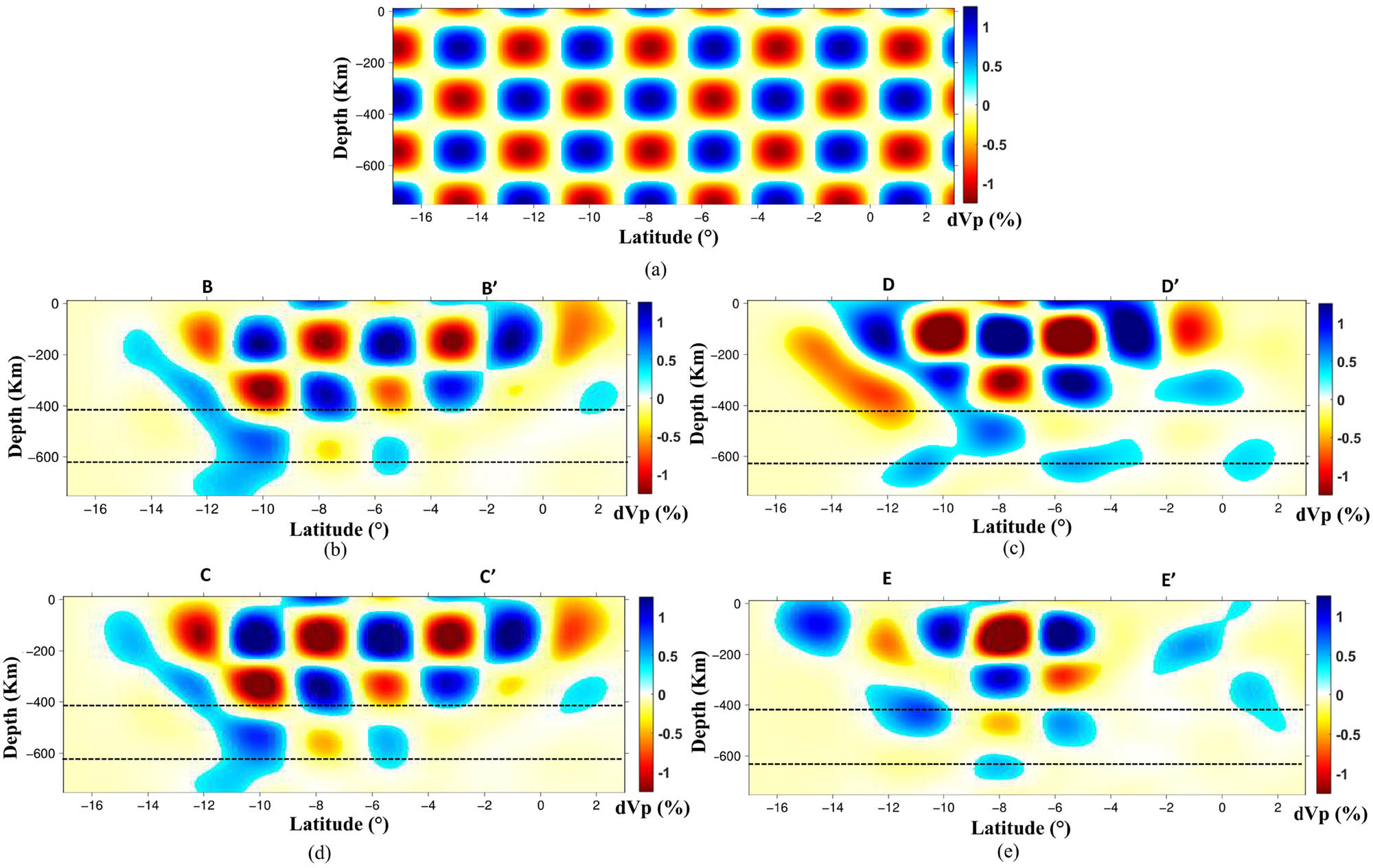
(a) Initial model of velocity and inversion results for the resolution test using the medium-resolution checkerboard test method, and (b–e) vertical cross-section resulting from the inversion at B-B′ Longitude 115° E, C-C′ Longitude 116° E, D-D′ Longitude 117° E, and E-E′ Longitude 118° E” with a south–north direction. Blue represents the high velocities, while red represents low velocities.
5 Result and discussion
In Figure 7, Section A-A′, a high-velocity anomaly is observed in the eastern part of the region. This anomaly extends for approximately 200 km and corresponds to the subduction zone beneath Java Island in Indonesia. Subduction zones, where one tectonic plate forces beneath another, give rise to various geological phenomena such as volcanic eruptions, earthquakes, and seismic events [31,32]. Low-velocity anomalies between 200 and 400 km indicate a subducted oceanic lithosphere beneath Java Island. These findings suggest ongoing tectonic activity associated with subduction processes [9,33,34]. The subduction of the Indo-Australian Plate beneath the Eurasian Plate in the Java Trench directly influences geological activities such as volcanic eruptions, earthquakes, and other seismic events in this region. Cross-section A-A′ reveals several deep earthquakes occurring within regions characterized by high seismic velocities ranging from 450 to 670 km. These velocity anomalies in the lower mantle highlight the complex processes that occur within subducting slabs. Studying seismic velocity anomalies in subduction zones provides a deeper understanding of subduction mechanisms and plate tectonics. Furthermore, some previous studies have suggested that various factors, such as plastic instabilities, shear-induced melting, recrystallization, or polymorphic phase transformation, could potentially play a role in triggering these deep-seated earthquakes [35,36]. The study of seismic velocity anomalies in subduction zones provides valuable insights into plate tectonics and subduction dynamics. Either plate subduction or the upward movement of mantle material could cause these deep earthquakes. Since these deep earthquakes happen in areas with high seismic velocities, it is possible that fluids from subducted oceanic crust that are dry could be the cause of lower seismic velocities in some places [37,38].
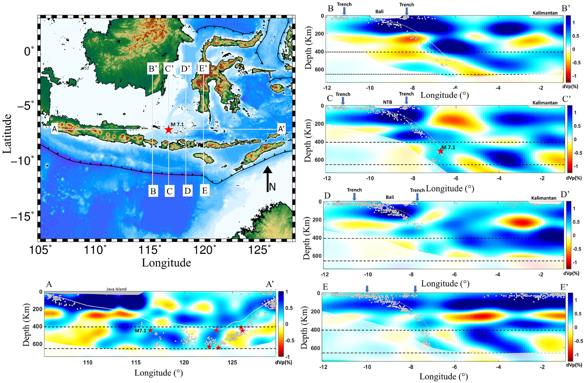
Horizontal and vertical cross-sections of the tomographic inversion result show anomalies in velocity. Blue signifies the high velocity, while red correlates with low velocity. The red star represents the epicentre of a deep earthquake, and the dashed line marks the mantle transition. Hypocentre earthquakes are represented by white dots.
In section B-B′ of Figure 7, it is shown that there are steeply dipping high-velocity anomalies extending to the northern part of the Bali Sea up to a depth of 400 km. There is a possibility that the occurrence of high-velocity anomalies is connected to the mass density that is associated with the subduction of the oceanic plate beneath the island of Bali, which implies the presence of a subducted slab in this location. In the Bali Sea region, where the Indo-Australian plate is subducting beneath the Eurasian plate, we suggest that high-velocity anomalies indicate the presence of a subducted slab. These anomalies arise because subducted slabs consist of cold, dense oceanic lithosphere that has descended into the Earth’s mantle. Due to its lower temperature and higher density compared to the surrounding mantle material, the subducted slab allows seismic waves to travel faster through it, resulting in the detection of these high-velocity anomalies in seismic tomography. The occurrence of high-velocity anomalies might be related to processes like subduction of the Indo-Australian plate or the existence of a deep-seated structure like a mantle wedge [9,34,39]. The presence of a deflected high-velocity anomaly from 400 to 600 km in the deeper part of the B-B′ cross-section suggests the variations in strength parameters at the subduction interface and mantle wedge, as well as inter-plate friction coefficients, likely contribute to these behaviours. Different mechanisms operate at varying depths in subduction zones, with brittle deformation dominating in shallower areas and ductile behaviour prevailing in deeper sections. The observed variation can be attributed to factors such as the subduction angle, properties of materials being subducted, and interactions between lithospheric plates. The Bali Sea subduction zone experiences both thrust-faulting earthquakes and along-arc compression, indicating a combination of brittle and ductile deformation. Overall, the Sunda–Banda arc transition is an area characterized by intense seismic activity influenced by various processes such as subduction, collision, back-arc thrust faults, and the presence of a slab window or missing subduction material [18]. The behaviours in this area are influenced by variations in strength parameters at the subduction interface and mantle wedge, as well as inter-plate friction coefficients. Ongoing research and monitoring are necessary to improve our understanding of subduction zone dynamics [40]. The Bali Sea subduction zone experiences both thrust-faulting earthquakes and along-arc compression, indicating a combination of brittle and ductile deformation.
The earthquake on August 29, 2023, in the eastern area with a C-C′ cross section (Figure 7) occurred in a region with high velocities. Deep earthquakes in this region may be a result of the interaction between the subducting lithosphere and the surrounding mantle. Studies [37,41,42,43,44] suggest that transformational faulting, resulting from the phase transformation of metastable olivine to denser spinel at great depths, triggers deep earthquakes. One possible explanation for the occurrence of deep earthquakes in regions with high-velocity anomalies is the interaction between the subducting lithosphere and the surrounding mantle [45,46]. Deep earthquakes present a challenge in terms of understanding their mechanisms and how they relate to mantle dynamics. The feasibility of transformational faulting being responsible for deep earthquakes depends on the presence of a sufficient amount of metastable phase within them [47,48,49]. Factors such as the thermal structure of slabs and stress conditions at the upper-lower mantle boundary influence the viability of these different mechanisms [50,51].
The Sunda–Banda transition zone shows intriguing results in both D-D′ and E-E′ (Figure 7). These regions, located within the transition zone, have been a subject of interest for geologists and researchers due to the presence of an old subduction beneath Borneo Island in Indonesia. The relationship between this old subduction zone and seismic velocity is currently under active investigation. External stresses from sources such as the Australia–Indonesia collision zone, deformation around Sulawesi, or collisional events in the Philippines are believed to influence the reactivation of the old subduction beneath Borneo Island [52,53]. A comprehensive understanding of the geological processes at play requires further investigation into the relationship between old subduction beneath Borneo Island in Indonesia, seismic velocity variations, and tectonic events. This includes examining the presence of a “slab window” or “window of missing subduction material” in the slab beneath the Sunda–Banda transition subduction zone [9,34,39]. Figure 7 displays the gap at depths below 350 km in the Sunda–Banda subduction zone on the D-D′ and E-E′ cross-sections. A transition in stress and heterogeneity within the slab is believed to cause this gap in the subducting slab. It is a significant geological feature with implications for tectonic processes and dynamics in this subduction zone [9,34,39,43,54]. The subducted slab structure in the lower mantle is related to the Tertiary evolution of south-eastern Asia and the Indian Ocean region [9,56]. Further studies are required to investigate the correlation between old subduction beneath Bali Island in Indonesia and seismic velocity variations, as well as their implications for tectonic activity.
According to Zhu et al. [56], the low-velocity anomalies in the oceanic plate may offer some hints regarding the significant intraplate seismicity, while the high-velocity anomalies from tomographic pictures are typically understood as subducting lithosphere or mantle plume in the deep, respectively. Deep earthquakes in the A-A′ to E-E′ cross-section may be caused by transformational faulting, an occurrence that happens when metastable olivine changes phases to become denser spinel. This phenomenon is caused by variances in velocity that are considerably higher than the average, as well as the interaction between the falling lithosphere and the surrounding mantle. Understanding the mechanisms and relationship between deep earthquakes and mantle dynamics is a challenging endeavour. The presence of a sufficient metastable phase is necessary for transformational faulting to be the cause; these mechanisms are influenced by the slab’s thermal structure and the stress conditions at the upper–lower mantle boundary. Based on the result of tomographic inversion, the occurrences of deep earthquakes are associated with regions of high P-wave velocity anomalies, which are linked to subduction zone. Therefore, earthquakes are likely to occur along these high-velocity anomalies. However, the precise location of potential earthquakes cannot yet be determined within the context of earthquake prediction. This study concludes that the earthquake on August 29, 2023, with magnitude greater than M7 and occurring at a depth of 512 km, is linked to a region of high-velocity anomaly. While this anomaly may result from various factors, geological history analysis suggests a connection to ancient subduction processes. Tomographic inversion results support the hypothesis that the earthquake is most plausibly associated with the presence of metastable olivine in the upper mantle transition zone.
Further research is needed to understand the relationship between old subduction, seismic velocity variations, and tectonic activity in the Sunda–Banda transition zone. Understanding factors such as far-field stresses, deformation around Sulawesi, and collisional events in the Philippines could help us understand the Earth’s crust. Tomography seismic data collected after a significant earthquake can provide a better understanding of the Earth’s lithosphere’s structure and behaviour in this complex area. This information can enhance preparedness efforts and response strategies for future seismic events. The insights gained from tomography seismic technology could have broader implications for geodynamics and plate tectonics, shedding light on the dynamic processes shaping the Earth’s surface and deep interior. The continuous study and use of tomography seismic data hold great promise for advancing our knowledge of tectonic processes in geologically complex areas worldwide.
6 Conclusion
Seismic velocity anomalies in subduction zones may provide insight into the mechanics of subduction and plate tectonics. The high-velocity anomalies observed to the western part of study region, extending over a length of 200 km, exhibit a strong correlation with the subduction zone located beneath Java Island, Indonesia. Low-velocity anomalies suggest the presence of a subducted oceanic lithosphere beneath Java Island. Examining these irregularities provides a valuable understanding of the movements of tectonic plates and the process of subduction. It indicates that plastic instabilities, shear-induced melting, recrystallization, or polymorphic phase transformation may be possible triggers for these earthquakes that occur deep within the Earth. The subduction zone in the Bali Sea undergoes both thrust-faulting earthquakes and along-arc compression, which suggests a mixture of brittle and ductile deformation. This study concludes that the August 29, 2023, earthquake, with a magnitude greater than M7 and 512 km depth, is linked to a high-velocity anomaly, possibly due to ancient subduction processes. Tomographic inversion results suggest that the earthquake is most likely associated with metastable olivine in the upper mantle transition zone.
Acknowledgement
We thank Ministry of Education, Culture, Research and Technology for Scholarship.
-
Author contributions: Mia Uswatun Hasanah: Writing – original draft, Visualization, Resources, Methodology, Investigation, Formal analysis, Conceptualization. Pepen Supendi: Writing – review & editing, Supervision, Conceptualization. Andri Dian Nugraha : Writing – review & editing, Supervision, Formal analysis. Sri Widiyantoro: Writing – review & editing, Supervision, Formal analysis. Firman Syaifuddin: Visualization, Data curation.
-
Conflict of interest: Authors state no conflict of interest.
-
Data availability statement: The data is open source at https://www.isc.ac.uk/isc-ehb/search/.
References
[1] Zheng YF, Zhao ZF. Introduction to the structures and processes of subduction zones. J Asian Earth Sci. 2017;145:1–15. 10.1016/j.jseaes.2017.06.034.Suche in Google Scholar
[2] Stern RJ. Subduction zones. Rev Geophysics. 2002;404:3-1–3-38. 10.1029/2001RG000108.Suche in Google Scholar
[3] Widiyantoro S, Gunawan E, Muhari A, Rawlinson N, Mori J, Hanifa NR, et al. Implications for megathrust earthquakes and tsunamis from seismic gaps south of Java Indonesia. Sci Rep. 2020;101:1–11. 10.1038/s41598-020-72142-z.Suche in Google Scholar PubMed PubMed Central
[4] Sulaeman C, Hidayati S, OmangA, Priambodo IC. Tectonic model of Bali Island inferred from GPS data. Indones J Geosci. 2018;5:81–91. 10.17014/ijog.5.1.81-91.Suche in Google Scholar
[5] Haolia, Sulaiman MI, Brilianti PT, Nugroho RP, Madrinovella I, Abdullah A, et al. IOP Conf Series: Earth Env Sci. 2021;8731:012067. 10.1088/1755-1315/873/1/012067.Suche in Google Scholar
[6] El-Nabulsi RA, Anukool W. Fractal dimension modeling of seismology and earthquakes dynamics. Acta Mech. 2022;233:2107–22. 10.1007/s00707-022-03213-7.Suche in Google Scholar
[7] Marcaillou B, Collot JY, Ribodetti A, D’Acremont E, Mahamat AA, Alvarado A. Seamount subduction at the North-Ecuadorian convergent margin: Effects on structures, inter-seismic coupling and seismogenesis. Earth Planet Sci Lett. 2016;433:146–58. 10.1016/j.epsl.2015.10.043.Suche in Google Scholar
[8] Montési LGJ. Controls of shear zone rheology and tectonic loading on post seismic creep. Journal of Geophysical Research Atmospheres. 2004;109(B10). 10.1029/2003jb002925.Suche in Google Scholar
[9] Widiyantoro S, Hilst R. Mantle structure beneath Indonesia inferred from high-resolution tomographic imaging. Geophys J Int. 1997;1301:167–82. 10.1111/j.1365-246X.1997.tb00996.Suche in Google Scholar
[10] Sunaryo N, Dewati AH, Anggono T. Distribution of seismic wave velocity beneath Sunda-Banda arc transition zone using Local Earthquake Tomography. AIP Conf Proc. 2019;2169:1–14. 10.1063/1.5132674.Suche in Google Scholar
[11] Tregoning P, Brunner FK, Bock Y, Puntodewo SSO, McCaffrey R, Genrich JF, et al. First geodetic measurement of convergence across the Java Trench. Geophys Res Lett. 1994;21(19):2135–8. 10.1029/94GL01856.Suche in Google Scholar
[12] Bock Y, Prawirodirdjo L, Genrich JF, Stevens CW, McCaffrey R, Subarya C, et al. Crustal motion in Indonesia from global positioning system measurements. J Geophys Res Atmospheres. 2003b;108:1–21. 10.1029/2001jb000324.Suche in Google Scholar
[13] DeMets C, Gordon RG, Argus DF. Geologically current plate motions. Geophys J Int. 2010;181(1):1–80. 10.1111/j.1365-246X.2009.04491.x.Suche in Google Scholar
[14] Lauterjung J, Münch U, Rudloff A. The challenge of installing a tsunami early warning system in the vicinity of the Sunda Arc, Indonesia. Nat Hazards Earth Syst Sci. 2010;10(4):641–6. 10.5194/nhess-10-641-2010.Suche in Google Scholar
[15] Verstappen H. Indonesian landforms and plate tectonics. Indones J Geosci. 2014;5(3):197–207. Directory of Open Access Journals. 10.17014/ijog.5.3.197-207.Suche in Google Scholar
[16] Hall R, Spakman W. Mantle structure and tectonic history of SE Asia. Tectonophysics. 2015;658:14–45. 10.1016/j.tecto.2015.07.003.Suche in Google Scholar
[17] Li J, Ding W, Lin J, Xu Y, Kong F, Li S, et al. Dynamic processes of the curved subduction system in Southeast Asia: A review and future perspective. Earth-Sci. Rev. 2021;217:103647. 10.1016/j.earscirev.2021.103647.Suche in Google Scholar
[18] Supendi P, Rawlinson N, Nugraha AD, Widiyantoro S, Abdullah CI, Daryono, et al. Focal mechanism analysis of the Earthquakes Beneath the Sunda-Banda arc transition, Indonesia, using the BMKG data. IOP Conf Ser: Earth Env Sci. 2022;1031(1):012012. 10.1088/1755-1315/1031/1/012012.Suche in Google Scholar
[19] Engdahl ER, Di Giacomo D, Sakarya B, Gkarlaoun CG, Harris J, Storchak DA. ISC-EHB 1964-2016, an improved data set for studies of Earth structure and global seismicity. Earth Space Sci. 2020;71:e2019EA000897. 10.1029/2019EA000897.Suche in Google Scholar
[20] International Seismological Centre 2020, ISC-EHB dataset, 10.31905/PY08W6S3.Suche in Google Scholar
[21] Fatini MA, Herwangi Y. Factors that influence tourism recovery, post disaster earthquake in Sembalun Sub-District, East Lombok Regency. Built Environ Stud. 2022;31:27–40. 10.22146/best.v3i1.1871.Suche in Google Scholar
[22] Syahbana DK, Kasbani K, Suantika G, Prambada O, Andreas AS, Saing UB, et al. The 2017–19 activity at Mount Agung in Bali (Indonesia): Intense unrest, monitoring, crisis response, evacuation, and eruption. Sci Rep. 2019;9(1):1–17. 10.1038/s41598-019-45295-9.Suche in Google Scholar PubMed PubMed Central
[23] McCaffrey R, Nabelek J. Earthquakes, gravity, and the origin of the Bali Basin: An example of a nascent continental fold‐and‐thrust belt. J Geophys Res Atmospheres. 1987;92B1:441–60. 10.1029/jb092ib01p00441.Suche in Google Scholar
[24] Kennett BLN, Engdahl ER, Buland R. Constraints on seismic velocities in the Earth from traveltimes. Geophys J Int. 1995;122(1):108–24. 10.1111/j.1365-246X.1995.tb03540.x.Suche in Google Scholar
[25] Srigutomo W, Muslim GH. Fast marching method application for forward modeling of seismic wave propagation. J Geophysics. 2018;16(3):1–13. 10.36435/jgf.v16i3.107.Suche in Google Scholar
[26] De Kool M, Rawlinso N, Sambridge M. A practical grid-based method for tracking multiple refraction and reflection phases in three-dimensional heterogeneous media. Geophys J Int. 2006;167(1):253–70. 10.1111/j.1365-246X.2006.03078.x.Suche in Google Scholar
[27] Rawlinson N, Sambridge M. Multiple reflection and transmission phases in complex layered media using a multistage fast-marching method. Geophysics. 2004;695:1338–50. 10.1190/1.1801950.Suche in Google Scholar
[28] Rawlinson N, Sambridge M. Wave front evolution in strongly heterogeneous layered media using the fast marching method. Geophys J Int. 2004;156(3):631–47. 10.1111/j.1365-246x.2004.02153.x.Suche in Google Scholar
[29] Rawlinson N, Sambridge M. The fast marching method: an effective tool for tomographic imaging and tracking multiple phases in complex layered media. Explor Geophys. 2005;36(4):341–50. 10.1071/eg05341.Suche in Google Scholar
[30] Hayes G. Slab2 – A comprehensive subduction zone geometry model. U.S. Geological Survey data release; 2018. 10.5066/F7PV6JNV.Suche in Google Scholar
[31] Hall R. Cenozoic geological dan plate tectonic evolution of SE Asia dan the SW Pacific: computer–based reconstructions, model dan animations. J Asian Earth Sci. 2002;204:353–431, https://api.semanticscholar.org/CorpusID:140189471.10.1016/S1367-9120(01)00069-4Suche in Google Scholar
[32] Hall R, Cottam MA, Wilson ME. The SE Asian gateway: history dan tectonics of the Australia–Asia collision. Geol Soc London Spec Publ. 2011;3551:75–109. 10.1144/SP355.5.Suche in Google Scholar
[33] Puspito NT, Yamanaka Y, Miyataki T, Shimazaki K, Hirahara K. Three-dimensional P-wave velocity structure beneath the Indonesian region. Tectonophysics. 1993;220(1–4):175–92. 10.1016/0040-19519390230-H.Suche in Google Scholar
[34] Zenonos A, De Siena L, Widiyantoro S, Rawlinson N. Direct inversion of S-P differential arrival times for Vp/Vs ratio in SE Asia. JGR Solid Earth. 2019;125(5):e2019JB019152. 10.17863/CAM.41290.Suche in Google Scholar
[35] Okazaki K, Hirth G. Dehydration of lawsonite could directly trigger earthquakes in subducting oceanic crust. Nature. 2016;530(7588):81–4. 10.1038/nature16501. PMID: 26842057.Suche in Google Scholar PubMed
[36] Schmidt C, Bruhn D, Wirth R. Experimental evidence of transformation plasticity in silicates: minimum of creep strength in quartz. Earth Planet Sci Lett. 2003;205(3–4):273–80. 10.1016/S0012-821X0201046-4.Suche in Google Scholar
[37] Kirby S, Stein S, Okal E, Rubie D. Metastable mantle phase transformations and deep earthquakes in subducting oceanic lithosphere. Rev Geophysics. 1996;34:261–306. 10.1029/96RG01050.Suche in Google Scholar
[38] Houston H. Deep earthquakes. Treatise on geophysics vol. 4, 2nd edn. Amsterdam, The Netherlands: Elsevier; 2015. p. 329–54. 10.1016/B978-0-444-53802-4.00079-8.Suche in Google Scholar
[39] Zenonos A, De Siena L, Widiyantoro S, Rawlinson N. Direct inversion of S‐P differential arrival times for ratio in SE Asia. J Geophys Res Solid Earth. 2020;125(5):e2019JB019152. 10.1029/2019jb019152.Suche in Google Scholar
[40] Kopp H. The control of subduction zone structural complexity and geometry on margin segmentation and seismicity. Tectonophysics. 2013;589:1–16. 10.1016/j.tecto.2012.12.037.Suche in Google Scholar
[41] Antolik M, Dreger D, Romanowicz B. Finite fault source study of the Great 1994 Deep Bolivia Earthquake. Geophys Res Lett. 1996;2313:1589–92. 10.1029/96gl00968.Suche in Google Scholar
[42] Zhao D, Fujisawa M, Toyokuni G. Tomography of the subducting Pacific slab and the 2015 Bonin deepest earthquake Mw 7.9. Sci Rep. 2017;71:1–8. 10.1038/srep44487.Suche in Google Scholar PubMed PubMed Central
[43] Green II H, Burnley PA. New self-organizing mechanism for deep-focus earthquakes. Nature. 1989;341:733–7. 10.1038/341733a0.Suche in Google Scholar
[44] Wiens D, McGuire J, Shor P. Evidence for transformational faulting from a deep double seismic zone in Tonga. Nature. 1993;364:790–3. 10.1038/364790a0.Suche in Google Scholar
[45] Huang Z, Zhao D, Wang L. P wave tomography and anisotropy beneath Southeast Asia: Insight into mantle dynamics. J Geophys Res: Solid Earth. 2015;1207:5154–74. 10.1002/2015JB012098.Suche in Google Scholar
[46] Huang Z, Zhao D, Wang L. Seismic heterogeneity and anisotropy of the Honshu arc from the Japan trench to the Japan Sea. Geophys J Int. 2011;1843:1428–44. 10.1111/j.1365-246X.2011.04934.Suche in Google Scholar
[47] lidaka T, Suetsugu D. Seismological evidence for metastable olivine inside a subducting slab. Nature. 1992;356:593–5. 10.1038/356593a0.Suche in Google Scholar
[48] Ishise M, Oda H. Subduction of the Philippine Sea slab in view of P-wave anisotropy. Phys Earth Planet Inter. 2008;1661–2:83–96. 10.1016/j.pepi.2007.11.003.Suche in Google Scholar
[49] Kawakatsu H, Yoshioka S. Metastable olivine wedge and deep dry cold slab beneath southwest Japan. Earth Planet Sci Lett. 2011;303(1–2):1–10. 10.1016/j.epsl.2011.01.008.Suche in Google Scholar
[50] Kuge K. Seismic observations indicating that the 2015 Ogasawara (Bonin) earthquake ruptured beneath the 660 km discontinuity. Geophys Res Lett. 2017;44(21):10855–62. 10.1002/2017gl074469.Suche in Google Scholar
[51] Karato S, Riedel M, Yuen D. Rheological structure and deformation of subducted slabs in the mantle transition zone: implications for mantle circulation and deep earthquakes. Phys Earth Planet Inter. 2001;127(1–4):83–108. 10.1016/S0031-92010100223-0.Suche in Google Scholar
[52] Hal R. Late Jurassic–Cenozoic reconstructions of the Indonesian region and the Indian Ocean. Tectonophysics. 2012;570–571:1–41. 10.1016/j.tecto.2012.04.021.Suche in Google Scholar
[53] Breitfeld HT, Davies L, Hall R, Armstrong R, Forster M, Lister G, et al. Mesozoic Paleo-Pacific subduction beneath SW Borneo: U-Pb geochronology of the Schwaner granitoids and the Pinoh metamorphic group. Front Earth Sci. 2020;8:1–37. 10.3389/feart.2020.568715.Suche in Google Scholar
[54] Green H. Shearing instabilities accompanying high-pressure phase transformations and the mechanics of deep earthquakes. Proc Natl Acad Sci U S A. 2007;104:9133–913. 10.1073/pnas.0608045104.Suche in Google Scholar PubMed PubMed Central
[55] Hamilton WB. Tectonics of the Indonesian region vol. 1078. Sunrise Valley Drive Reston, USA: USGS Publications Warehouse; 1979. https://pubs.usgs.gov/publication/pp1078.Suche in Google Scholar
[56] Zhu J, Li S, Jia Y, Zhang S, Chen X, Chen R, et al. Links of high velocity anomalies in the mantle to the Proto-South China Sea slabs: Tomography-based review and perspective. Earth-Sci Rev. 2022;231:104074. 10.1016/j.earscirev.2022.104074.Suche in Google Scholar
© 2024 the author(s), published by De Gruyter
This work is licensed under the Creative Commons Attribution 4.0 International License.
Artikel in diesem Heft
- Regular Articles
- Theoretical magnetotelluric response of stratiform earth consisting of alternative homogeneous and transitional layers
- The research of common drought indexes for the application to the drought monitoring in the region of Jin Sha river
- Evolutionary game analysis of government, businesses, and consumers in high-standard farmland low-carbon construction
- On the use of low-frequency passive seismic as a direct hydrocarbon indicator: A case study at Banyubang oil field, Indonesia
- Water transportation planning in connection with extreme weather conditions; case study – Port of Novi Sad, Serbia
- Zircon U–Pb ages of the Paleozoic volcaniclastic strata in the Junggar Basin, NW China
- Monitoring of mangrove forests vegetation based on optical versus microwave data: A case study western coast of Saudi Arabia
- Microfacies analysis of marine shale: A case study of the shales of the Wufeng–Longmaxi formation in the western Chongqing, Sichuan Basin, China
- Multisource remote sensing image fusion processing in plateau seismic region feature information extraction and application analysis – An example of the Menyuan Ms6.9 earthquake on January 8, 2022
- Identification of magnetic mineralogy and paleo-flow direction of the Miocene-quaternary volcanic products in the north of Lake Van, Eastern Turkey
- Impact of fully rotating steel casing bored pile on adjacent tunnels
- Adolescents’ consumption intentions toward leisure tourism in high-risk leisure environments in riverine areas
- Petrogenesis of Jurassic granitic rocks in South China Block: Implications for events related to subduction of Paleo-Pacific plate
- Differences in urban daytime and night block vitality based on mobile phone signaling data: A case study of Kunming’s urban district
- Random forest and artificial neural network-based tsunami forests classification using data fusion of Sentinel-2 and Airbus Vision-1 satellites: A case study of Garhi Chandan, Pakistan
- Integrated geophysical approach for detection and size-geometry characterization of a multiscale karst system in carbonate units, semiarid Brazil
- Spatial and temporal changes in ecosystem services value and analysis of driving factors in the Yangtze River Delta Region
- Deep fault sliding rates for Ka-Ping block of Xinjiang based on repeating earthquakes
- Improved deep learning segmentation of outdoor point clouds with different sampling strategies and using intensities
- Platform margin belt structure and sedimentation characteristics of Changxing Formation reefs on both sides of the Kaijiang-Liangping trough, eastern Sichuan Basin, China
- Enhancing attapulgite and cement-modified loess for effective landfill lining: A study on seepage prevention and Cu/Pb ion adsorption
- Flood risk assessment, a case study in an arid environment of Southeast Morocco
- Lower limits of physical properties and classification evaluation criteria of the tight reservoir in the Ahe Formation in the Dibei Area of the Kuqa depression
- Evaluation of Viaducts’ contribution to road network accessibility in the Yunnan–Guizhou area based on the node deletion method
- Permian tectonic switch of the southern Central Asian Orogenic Belt: Constraints from magmatism in the southern Alxa region, NW China
- Element geochemical differences in lower Cambrian black shales with hydrothermal sedimentation in the Yangtze block, South China
- Three-dimensional finite-memory quasi-Newton inversion of the magnetotelluric based on unstructured grids
- Obliquity-paced summer monsoon from the Shilou red clay section on the eastern Chinese Loess Plateau
- Classification and logging identification of reservoir space near the upper Ordovician pinch-out line in Tahe Oilfield
- Ultra-deep channel sand body target recognition method based on improved deep learning under UAV cluster
- New formula to determine flyrock distance on sedimentary rocks with low strength
- Assessing the ecological security of tourism in Northeast China
- Effective reservoir identification and sweet spot prediction in Chang 8 Member tight oil reservoirs in Huanjiang area, Ordos Basin
- Detecting heterogeneity of spatial accessibility to sports facilities for adolescents at fine scale: A case study in Changsha, China
- Effects of freeze–thaw cycles on soil nutrients by soft rock and sand remodeling
- Vibration prediction with a method based on the absorption property of blast-induced seismic waves: A case study
- A new look at the geodynamic development of the Ediacaran–early Cambrian forearc basalts of the Tannuola-Khamsara Island Arc (Central Asia, Russia): Conclusions from geological, geochemical, and Nd-isotope data
- Spatio-temporal analysis of the driving factors of urban land use expansion in China: A study of the Yangtze River Delta region
- Selection of Euler deconvolution solutions using the enhanced horizontal gradient and stable vertical differentiation
- Phase change of the Ordovician hydrocarbon in the Tarim Basin: A case study from the Halahatang–Shunbei area
- Using interpretative structure model and analytical network process for optimum site selection of airport locations in Delta Egypt
- Geochemistry of magnetite from Fe-skarn deposits along the central Loei Fold Belt, Thailand
- Functional typology of settlements in the Srem region, Serbia
- Hunger Games Search for the elucidation of gravity anomalies with application to geothermal energy investigations and volcanic activity studies
- Addressing incomplete tile phenomena in image tiling: Introducing the grid six-intersection model
- Evaluation and control model for resilience of water resource building system based on fuzzy comprehensive evaluation method and its application
- MIF and AHP methods for delineation of groundwater potential zones using remote sensing and GIS techniques in Tirunelveli, Tenkasi District, India
- New database for the estimation of dynamic coefficient of friction of snow
- Measuring urban growth dynamics: A study in Hue city, Vietnam
- Comparative models of support-vector machine, multilayer perceptron, and decision tree predication approaches for landslide susceptibility analysis
- Experimental study on the influence of clay content on the shear strength of silty soil and mechanism analysis
- Geosite assessment as a contribution to the sustainable development of Babušnica, Serbia
- Using fuzzy analytical hierarchy process for road transportation services management based on remote sensing and GIS technology
- Accumulation mechanism of multi-type unconventional oil and gas reservoirs in Northern China: Taking Hari Sag of the Yin’e Basin as an example
- TOC prediction of source rocks based on the convolutional neural network and logging curves – A case study of Pinghu Formation in Xihu Sag
- A method for fast detection of wind farms from remote sensing images using deep learning and geospatial analysis
- Spatial distribution and driving factors of karst rocky desertification in Southwest China based on GIS and geodetector
- Physicochemical and mineralogical composition studies of clays from Share and Tshonga areas, Northern Bida Basin, Nigeria: Implications for Geophagia
- Geochemical sedimentary records of eutrophication and environmental change in Chaohu Lake, East China
- Research progress of freeze–thaw rock using bibliometric analysis
- Mixed irrigation affects the composition and diversity of the soil bacterial community
- Examining the swelling potential of cohesive soils with high plasticity according to their index properties using GIS
- Geological genesis and identification of high-porosity and low-permeability sandstones in the Cretaceous Bashkirchik Formation, northern Tarim Basin
- Usability of PPGIS tools exemplified by geodiscussion – a tool for public participation in shaping public space
- Efficient development technology of Upper Paleozoic Lower Shihezi tight sandstone gas reservoir in northeastern Ordos Basin
- Assessment of soil resources of agricultural landscapes in Turkestan region of the Republic of Kazakhstan based on agrochemical indexes
- Evaluating the impact of DEM interpolation algorithms on relief index for soil resource management
- Petrogenetic relationship between plutonic and subvolcanic rocks in the Jurassic Shuikoushan complex, South China
- A novel workflow for shale lithology identification – A case study in the Gulong Depression, Songliao Basin, China
- Characteristics and main controlling factors of dolomite reservoirs in Fei-3 Member of Feixianguan Formation of Lower Triassic, Puguang area
- Impact of high-speed railway network on county-level accessibility and economic linkage in Jiangxi Province, China: A spatio-temporal data analysis
- Estimation model of wild fractional vegetation cover based on RGB vegetation index and its application
- Lithofacies, petrography, and geochemistry of the Lamphun oceanic plate stratigraphy: As a record of the subduction history of Paleo-Tethys in Chiang Mai-Chiang Rai Suture Zone of Thailand
- Structural features and tectonic activity of the Weihe Fault, central China
- Application of the wavelet transform and Hilbert–Huang transform in stratigraphic sequence division of Jurassic Shaximiao Formation in Southwest Sichuan Basin
- Structural detachment influences the shale gas preservation in the Wufeng-Longmaxi Formation, Northern Guizhou Province
- Distribution law of Chang 7 Member tight oil in the western Ordos Basin based on geological, logging and numerical simulation techniques
- Evaluation of alteration in the geothermal province west of Cappadocia, Türkiye: Mineralogical, petrographical, geochemical, and remote sensing data
- Numerical modeling of site response at large strains with simplified nonlinear models: Application to Lotung seismic array
- Quantitative characterization of granite failure intensity under dynamic disturbance from energy standpoint
- Characteristics of debris flow dynamics and prediction of the hazardous area in Bangou Village, Yanqing District, Beijing, China
- Rockfall mapping and susceptibility evaluation based on UAV high-resolution imagery and support vector machine method
- Statistical comparison analysis of different real-time kinematic methods for the development of photogrammetric products: CORS-RTK, CORS-RTK + PPK, RTK-DRTK2, and RTK + DRTK2 + GCP
- Hydrogeological mapping of fracture networks using earth observation data to improve rainfall–runoff modeling in arid mountains, Saudi Arabia
- Petrography and geochemistry of pegmatite and leucogranite of Ntega-Marangara area, Burundi, in relation to rare metal mineralisation
- Prediction of formation fracture pressure based on reinforcement learning and XGBoost
- Hazard zonation for potential earthquake-induced landslide in the eastern East Kunlun fault zone
- Monitoring water infiltration in multiple layers of sandstone coal mining model with cracks using ERT
- Study of the patterns of ice lake variation and the factors influencing these changes in the western Nyingchi area
- Productive conservation at the landslide prone area under the threat of rapid land cover changes
- Sedimentary processes and patterns in deposits corresponding to freshwater lake-facies of hyperpycnal flow – An experimental study based on flume depositional simulations
- Study on time-dependent injectability evaluation of mudstone considering the self-healing effect
- Detection of objects with diverse geometric shapes in GPR images using deep-learning methods
- Behavior of trace metals in sedimentary cores from marine and lacustrine environments in Algeria
- Spatiotemporal variation pattern and spatial coupling relationship between NDVI and LST in Mu Us Sandy Land
- Formation mechanism and oil-bearing properties of gravity flow sand body of Chang 63 sub-member of Yanchang Formation in Huaqing area, Ordos Basin
- Diagenesis of marine-continental transitional shale from the Upper Permian Longtan Formation in southern Sichuan Basin, China
- Vertical high-velocity structures and seismic activity in western Shandong Rise, China: Case study inspired by double-difference seismic tomography
- Spatial coupling relationship between metamorphic core complex and gold deposits: Constraints from geophysical electromagnetics
- Disparities in the geospatial allocation of public facilities from the perspective of living circles
- Research on spatial correlation structure of war heritage based on field theory. A case study of Jinzhai County, China
- Formation mechanisms of Qiaoba-Zhongdu Danxia landforms in southwestern Sichuan Province, China
- Magnetic data interpretation: Implication for structure and hydrocarbon potentiality at Delta Wadi Diit, Southeastern Egypt
- Deeply buried clastic rock diagenesis evolution mechanism of Dongdaohaizi sag in the center of Junggar fault basin, Northwest China
- Application of LS-RAPID to simulate the motion of two contrasting landslides triggered by earthquakes
- The new insight of tectonic setting in Sunda–Banda transition zone using tomography seismic. Case study: 7.1 M deep earthquake 29 August 2023
- The critical role of c and φ in ensuring stability: A study on rockfill dams
- Evidence of late quaternary activity of the Weining-Shuicheng Fault in Guizhou, China
- Extreme hydroclimatic events and response of vegetation in the eastern QTP since 10 ka
- Spatial–temporal effect of sea–land gradient on landscape pattern and ecological risk in the coastal zone: A case study of Dalian City
- Study on the influence mechanism of land use on carbon storage under multiple scenarios: A case study of Wenzhou
- A new method for identifying reservoir fluid properties based on well logging data: A case study from PL block of Bohai Bay Basin, North China
- Comparison between thermal models across the Middle Magdalena Valley, Eastern Cordillera, and Eastern Llanos basins in Colombia
- Mineralogical and elemental analysis of Kazakh coals from three mines: Preliminary insights from mode of occurrence to environmental impacts
- Chlorite-induced porosity evolution in multi-source tight sandstone reservoirs: A case study of the Shaximiao Formation in western Sichuan Basin
- Predicting stability factors for rotational failures in earth slopes and embankments using artificial intelligence techniques
- Origin of Late Cretaceous A-type granitoids in South China: Response to the rollback and retreat of the Paleo-Pacific plate
- Modification of dolomitization on reservoir spaces in reef–shoal complex: A case study of Permian Changxing Formation, Sichuan Basin, SW China
- Geological characteristics of the Daduhe gold belt, western Sichuan, China: Implications for exploration
- Rock physics model for deep coal-bed methane reservoir based on equivalent medium theory: A case study of Carboniferous-Permian in Eastern Ordos Basin
- Enhancing the total-field magnetic anomaly using the normalized source strength
- Shear wave velocity profiling of Riyadh City, Saudi Arabia, utilizing the multi-channel analysis of surface waves method
- Effect of coal facies on pore structure heterogeneity of coal measures: Quantitative characterization and comparative study
- Inversion method of organic matter content of different types of soils in black soil area based on hyperspectral indices
- Detection of seepage zones in artificial levees: A case study at the Körös River, Hungary
- Tight sandstone fluid detection technology based on multi-wave seismic data
- Characteristics and control techniques of soft rock tunnel lining cracks in high geo-stress environments: Case study of Wushaoling tunnel group
- Influence of pore structure characteristics on the Permian Shan-1 reservoir in Longdong, Southwest Ordos Basin, China
- Study on sedimentary model of Shanxi Formation – Lower Shihezi Formation in Da 17 well area of Daniudi gas field, Ordos Basin
- Multi-scenario territorial spatial simulation and dynamic changes: A case study of Jilin Province in China from 1985 to 2030
- Review Articles
- Major ascidian species with negative impacts on bivalve aquaculture: Current knowledge and future research aims
- Prediction and assessment of meteorological drought in southwest China using long short-term memory model
- Communication
- Essential questions in earth and geosciences according to large language models
- Erratum
- Erratum to “Random forest and artificial neural network-based tsunami forests classification using data fusion of Sentinel-2 and Airbus Vision-1 satellites: A case study of Garhi Chandan, Pakistan”
- Special Issue: Natural Resources and Environmental Risks: Towards a Sustainable Future - Part I
- Spatial-temporal and trend analysis of traffic accidents in AP Vojvodina (North Serbia)
- Exploring environmental awareness, knowledge, and safety: A comparative study among students in Montenegro and North Macedonia
- Determinants influencing tourists’ willingness to visit Türkiye – Impact of earthquake hazards on Serbian visitors’ preferences
- Application of remote sensing in monitoring land degradation: A case study of Stanari municipality (Bosnia and Herzegovina)
- Optimizing agricultural land use: A GIS-based assessment of suitability in the Sana River Basin, Bosnia and Herzegovina
- Assessing risk-prone areas in the Kratovska Reka catchment (North Macedonia) by integrating advanced geospatial analytics and flash flood potential index
- Analysis of the intensity of erosive processes and state of vegetation cover in the zone of influence of the Kolubara Mining Basin
- GIS-based spatial modeling of landslide susceptibility using BWM-LSI: A case study – city of Smederevo (Serbia)
- Geospatial modeling of wildfire susceptibility on a national scale in Montenegro: A comparative evaluation of F-AHP and FR methodologies
- Geosite assessment as the first step for the development of canyoning activities in North Montenegro
- Urban geoheritage and degradation risk assessment of the Sokograd fortress (Sokobanja, Eastern Serbia)
- Multi-hazard modeling of erosion and landslide susceptibility at the national scale in the example of North Macedonia
- Understanding seismic hazard resilience in Montenegro: A qualitative analysis of community preparedness and response capabilities
- Forest soil CO2 emission in Quercus robur level II monitoring site
- Characterization of glomalin proteins in soil: A potential indicator of erosion intensity
- Power of Terroir: Case study of Grašac at the Fruška Gora wine region (North Serbia)
- Special Issue: Geospatial and Environmental Dynamics - Part I
- Qualitative insights into cultural heritage protection in Serbia: Addressing legal and institutional gaps for disaster risk resilience