Hunger Games Search for the elucidation of gravity anomalies with application to geothermal energy investigations and volcanic activity studies
-
 ,
,
,
,

Abstract
Recent metaheuristic approaches are extensively and intensively being implemented to the interpretation of gravity anomalies due to their superior advantages. We emphasize the application of Hunger Games Search (HGS), a newly established metaheuristic inspired by hunger-driven instincts and behavioral choices of animals, to elucidate gravity data for geothermal energy exploration and volcanic activity study. After recognizing the modal features of the objective function tailored and tuning the algorithm control parameters involved, HGS has been trial-tested on simulated data sets of different scenarios and finally experienced in two field cases from India and Japan. Notably, a second moving average strategy has been successfully integrated into the objective function to eradicate the regional component from observed responses. Post-inversion uncertainty appraisal tests have been further implemented to comprehend the reliability of solutions obtained. The solutions retrieved by HGS have been unbiasedly compared in terms of convergence rate, accuracy, stability, and robustness with the solutions of the commonly used particle swarm optimization algorithm. Based on the results accessed, the theoretical and field cases presented could be recuperated more precisely, stably, robustly, and coherently with the available geophysical, geological, and borehole verification, as HGS is able to better explore the model space without compromising its capability to efficiently approach the global minimum. This novel global optimization method can thus be considered as a promising tool in geothermal energy investigations and the study of volcanic activities.
1 Introduction
The gravity method in geophysics, a traditional, passive, non-invasive, and cost-efficient method, measuring the variation in the Earth’s gravitational field caused by the difference of rock mass properties at a certain position, has been applied in a large spectrum of projects, including ore/mineral exploration [1,2,3,4,5], archaeology investigation [6,7,8,9], radioactive waste management [10], weapons and unexploded ordnances detection [11,12], hydrocarbon/reservoir (oil and gas) recognition [13,14,15], geothermal energy and volcanic activity study [16,17,18], underground cavity or tunnel identification [19,20,21], geotechnical and engineering application [22,23], groundwater monitoring [24,25], landfill mapping [26,27], and subsurface structure imaging [28,29,30]. It obtains the same quality as other constantly applied methods, which can remotely sense potential targets in terms of capturing their features and variations [31,32,33].
Especially, in geothermal energy and volcanic activity studies, the gravity method enables insights into the geometrical information of the causative sources, which are crucial for targeting the potential geothermal reservoirs [34] and clarify the geodynamic process based on the spatial and temporal volcanic variations, which have got up from earthquakes and interior movements, respectively [15,35]. Intrinsically, the goal of delineating the measured gravity response is to estimate the model parameters (amplitude coefficients, depths, and spatial locations) of buried sources from a precarious process due to the non-unique and ill-posed mathematical nature of the gravity inversion problem [36,37,38,39], namely, that numerous configurations are capable of reproducing observations within a given error tolerance. Such gravity structures can be considered as spherical, cylindrical, dike-like, fault-like structures, and sheets [18,40,41]. For these structures, versatile quantitative techniques have been proposed and implemented for better interpretation performances, which can be categorized as follows:
Conventional and non-conventional methods, which rely on the characteristic points, nomograms, window and depth curves, matching curves, various transformations, gradient-based minimization techniques, moving average, Euler deconvolution, depth to extreme point, and fair function [42,43,44,45,46,47,48,49,50,51,52].
Remarkably, nature-inspired derivative-free metaheuristic algorithms have been effectively applied with proper modifications, including particle swarm optimization (PSO), genetic algorithm, differential evolution, differential search, simulated annealing, ant colony optimization, gravitational search algorithm, bat algorithm (BA), manta-ray foraging optimization, and modified barnacles mating optimization [53,54,55,56,57,58,59,60,61,62,63,64,65,66].
However, generally, the correctness and accuracy of the results obtained by the interpretation techniques aforementioned rely on the precision by which the anomaly of the source structure(s) is extracted from the entire measured information. The merits of these algorithms have been verified in various ways even though the so-called derivative-based local optimizers require a priori information. Their success largely depends on the choice of the initial guess, and therefore, they cannot entirely explore the model space and traditional global optimizers may be captured by massive local minima existed within the model space and may not be exploitable enough to approximate the global optimum when dealing with some problems.
Notably, in the late 1990s, researchers proposed the joint inversion technique [67] to better address the above-mentioned non-unique and ill-posed mathematical nature of geophysical methods [68,69]. This approach efficiently reduces the ambiguity and non-uniqueness inherent in independent inversion procedures, leading to higher stability and accuracy in parameter estimation [70,71,72,73].
The effectiveness of Hunger Games Search (HGS) in interpreting the geomagnetic data caused by ore bodies was first validated in the study by Ai et al. [74]. Ai et al. [75] further verified the effectiveness of HGS for solving self-potential data inversion problems. We are thus motivated to further implement this novel global optimizer, HGS, for the delineation of gravity anomalies generated by different type of causative sources with application to geothermal energy identifications and volcanic activity studies. The superiority of HGS was verified in three theoretical cases of different circumstances. Practically, HGS was also experimented on two field cases from India and Japan. Prior to the inversion experiments, we implemented modal analyses to map the error topography of the objective function predetermined to understand the resolvability characteristics of model parameters and to investigate their effects. In applications, we successfully eliminated the regional background effect with the second moving average (SMA) technique. Some studies assessing post-inversion uncertainty were conducted to comprehend the consistency and credibility of the model solutions. Finally, the results of HGS applications were thoroughly, systematically, and unbiasedly compared with those of the well-established PSO algorithm regarding the trade-off of balancing the exploration and exploitation phases in metaheuristics. Previous geophysical, geological, and borehole studies were further gathered to generate coherent and convincing evaluations toward the two global optimizers involved.
2 Methods
2.1 Forward modeling
The general expression of gravity anomalies g(x i ) for a spherical structure, an infinite horizontal cylinder, or a semi-infinite vertical cylinder, at any given point x i along the principal profile on the free surface in a Cartesian coordinate system (Figure 1), is given by previous studies [18,76,77] as
where q stands for a shape factor (dimensionless), which determines the shape of the buried geological body; q = 1.5 (sphere), 1 (horizontal cylinder), and 0.5 (vertical cylinder); Δσ means the density contrast (g/cm3) between the causative source and the host rock; G denotes the universal gravitational constant (m3 kg−1 s−2); x 0 defines the horizontal coordinate of the geometrical center of the buried causative structure (m); k represents the amplitude factor (mGal m2q−1); and R is the radius of the buried object (m).

Geometries and parameters of (a) a sphere, (b) a horizontally placed infinite cylinder, and (c) a vertically placed semi-infinite cylinder.
2.2 Multi-source effect
The gravity anomaly caused by multiple sources is obtained by integrating the responses from individual targets:
where g j (x i ) represents the response at x i for jth source and P defines the number of causative gravity sources contained.
2.3 Undesired regional effect and local interruption
In a more general sense, the measured geophysical anomaly is composed of residual anomaly due to causative source(s), undesired regional anomaly, and local interference [41,60,78]:
In equation (3), g gen(x i ) defines the contaminated gravity data, g re(x i ) is the undesired regional background (c 0–c 3 are the predefined constants), and g local(x i ) represents the local perturbations originated from interfering source(s).
2.4 SMA method
The residual gravity anomaly is calculated by subtracting the regional component from the entire observed gravity response. Ai et al. [78] reported the effectiveness of the SMA method to achieve this goal, which is expressed by
where R 2(x) is the estimated residual gravity anomaly under the SMA frame and s (m) denotes the window length. Typically, we can simply use the mean output produced by inverting the SMA anomalies, which is controlled by s values to provide a reasonable prediction of the true model parameter set.
3 HGS optimizer
The HGS global optimization algorithm mathematically simulates the rules used by the animals during hunger, such as instinctive behaviors, preferences, and decisions. Yang et al. [79] clearly demonstrated the superiority of the HGS algorithm over the existing well-known global optimizers using 23 challenging benchmark functions. Ai et al. [74] further showed the effectiveness of HGS in the inversion of geomagnetic data. The mathematical background of the tailored HGS optimizer within this study can be briefly summarized as follows:
Communicating and preying characters of the predators are formulated by ref. [79]
where
In equation (6),
where
where
and
where
4 Objective function and stopping criteria
Employing HGS for interpretation of gravity anomalies associated with geothermal investigations and volcanic activities involves treating the model parameter set (R, Δσ, x 0, z 0, q) as search agents. These search agents are guided by numerically imitated hunger activities to iteratively converge. We terminated the iteration process when the predefined maximum iteration is reached. The objective function used to be minimized is the root-mean-square-error (RMSE) as follows:
where g obs is the observed data, g cal denotes the data calculated from the model parameters estimated, and M is the data size.
5 Modal analysis
Pre- and post-inversion uncertainty appraisal analyses are vital for understanding the ambiguity and credibility of the estimated model solutions due to the well-acknowledged non-uniqueness and ill-posedness of geophysical inverse problems [58,81,82]. We tend to investigate the modal type of the determined objective function by means of mapping and categorizing the error topographies within each parameter pairs so that the resolvability and possible uncertainties between model parameters can be acknowledged. Without the loss of generality, the objective function within the modal analysis is constructed as follows:
In equation (13),
True model parameters of the multi-source model (designed parameter searching spaces are also given)
| Model parameters | Spherical source | Search range | Horizontally placed infinite cylindrical body | Search range | Semi-infinite vertical cylinder | Search range |
|---|---|---|---|---|---|---|
| R (m) | 12,000 | 6,000–18,000 | 6,000 | 3,000–9,000 | 9,000 | 4,500–13,500 |
| Δσ (g/cm3) | 0.5 | 0.25–0.75 | 2 | 1–3 | −0.5 | −0.75 to −0.25 |
| x 0 (m) | −50,000 | −75,000 to −25,000 | 40,000 | 20,000–60,000 | −1,000 | −1,500 to −500 |
| z 0 (m) | 24,000 | 12,000–36,000 | 30,000 | 15,000–45,000 | 12,000 | 6,000–18,000 |
| q (dimensionless) | 1.5 | 0.75–2.25 | 1 | 0.5–1.5 | 0.5 | 0.25–0.75 |

Modal analysis (parameter set is (R, Δσ, x 0, z 0, q)) of the defined objective function (50% fluctuations are added to the original parameter set to generate the model space; distribution of log10(RMSE) in paired model parameter spaces (a–j) are illustrated; notably, these topographies are normalized to better demonstrating the variation characteristics).
6 Parameter-tuning studies for HGS and PSO
The effectiveness of global optimizers depends to a large extent on finely tuned control parameters because there is no algorithm-based control parameter value that suits all types of inverse problems [53,74,86]. Hence, a crucial step of effectively applying a metaheuristic is to find the best user-defined control parameter(s). As aforementioned, l and LH control the exploitation and exploration stages of HGS. To investigate the effect of tuning l and LH of HGS, a noise-free residual gravity anomaly derived from the previous multi-structure model was inverted (model parameters are still kept in Table 1). 50% oscillations of the true parameter set (R, Δσ, x 0, z 0, q) were adopted again, and the profile length (120 km) and station interval (3 km) were remained. HGS was independently performed 30 times with N = 80 and Max_iter = 140 in order to suppress the stochastic nature of metaheuristics so that more objective evaluation can be achieved. As l and LH of HGS vary successively, the mean values obtained are displayed in Figure 3a. Correspondingly, Figure 3b demonstrates the variation of the standard deviations of the calculated RMSE values, illustrating the inversion uncertainties. Curves in Figure 3 are normalized into [0,1] for better visualization. Different performances, which are controlled by various combinations of l and LH and very similar variation behaviors (Figure 3a and b), indicate that ill-determined l and LH can intensively reduce the performance of HGS in terms of affecting the solution correctness and the stableness of approximating the true parameter values. Moreover, l is a dominant factor in controlling the performance of HGS comparing to LH. The excellent performance of HGS is intensively corrupted with the amplification of l, however, mildly contaminated with the increment of LH. We finally determined the best combination of LH and l (LH = 10, l = 0.01).
![Figure 3
Analyzing the effect of tuning l and LH of HGS: (a) variation behavior of the mean RMSE values obtained via the increment of l and LH, (b) inverted uncertainties (STD values) of HGS via the variation of l and LH. The mean(RMSE) values and the STD(RMSE) values are normalized into [0,1] to better visualize the variation features.](/document/doi/10.1515/geo-2022-0641/asset/graphic/j_geo-2022-0641_fig_003.jpg)
Analyzing the effect of tuning l and LH of HGS: (a) variation behavior of the mean RMSE values obtained via the increment of l and LH, (b) inverted uncertainties (STD values) of HGS via the variation of l and LH. The mean(RMSE) values and the STD(RMSE) values are normalized into [0,1] to better visualize the variation features.
In order to make unbiased comparative studies, we performed tuning studies for the well-known PSO further. Inertia weight (w) and two social factors (c 1 and c 2) are the algorithm-based control parameters of PSO. We used the same N and Max_iter numbers as in the HGS-tuning studies. Nine parameter sets suggested in the literature were taken into consideration in the applications. The results of 30 independent runs of PSO are given in Table 2. The noise-less gravity response was generated by the introduced multi-source model. It is clearly seen that the best statistical results for the handling inversion problem were obtained with the use of the parameter set suggested by Carlisle and Dozier [87].
Statistical results of PSO-tuning studies
| References | Control parameters | Statistical results (mGal) | |||
|---|---|---|---|---|---|
| w | c 1 | c 2 | Mean | STD | |
| [87] | 0.729 | 2.041 | 0.948 | 3.14 | 0.97 |
| [88] | 1 | 2 | 2 | 12.50 | 0.32 |
| [89] | 0.6 | 1.7 | 1.7 | 4.21 | 3.54 |
| [90] | 0.715 | 1.7 | 1.7 | 11.39 | 1.73 |
| [91] | 0.9 | 2 | 2 | 15.006 | 0.70 |
| [92] | 0.729 | 1.494 | 1.494 | 5.85 | 1.43 |
| [93] | 0.729 | 2.05 | 2.05 | 13.51 | 1.56 |
| [94] | 0.729 | 2.8 | 1.3 | 9.57 | 1.62 |
| [95] | 0.8 | 1.8 | 2.0 | 12.32 | 0.401 |
7 Synthetic data tests
The HGS method was applied to three synthetic tests with different properties to investigate its merits of inversion. The first test involves a residual gravity anomaly produced by the introduced multi-structure model. To generate the second test, we added a regional background (third-order polynomial) together with a local interference due to a near-surface spherical source to the residual anomaly simulated. In the last synthetic test, the second case anomaly was further contaminated with a certain degree of normally distributed random noise. The superiority of HGS using the parameters LH = 10 and l = 0.01 was testified by comparing it with the results of the PSO algorithm (w = 0.729, c 1 = 2.041, and c 2 = 0.948). Furthermore, we investigated the validity of implementing the SMA approach to suppress the regional information.
7.1 Synthetic test 1
As discussed earlier, more generally, measured gravity anomalies are induced by multiple sources. We thus tested and compared the performance of HGS and PSO using anomalies derived from the multi-structure model:
The profile length and the station interval remained 120 and 3 km, respectively. Yellow symbols with a black line through the center in Figure 4 illustrate the simulated gravity anomaly, where deep gravity source (vertical cylinder) produces a broad negative anomaly curve (blue symbols with a black line through the center), while shallow causative structures (sphere and horizontal cylinder) generate narrow and sharp positive anomaly curves (black and green symbols with a black line through the center). For the inversion process, 30 independent runs were carried out with 80 search agents (N = 80) and 140 iterations for both HGS and PSO. Notably, we obtained the same number of model solutions as the number of independent runs; we thus followed the idea of averaging solutions within a specific range of the minimum [74,75] to generate the final output of both optimizers. We initially sorted the results from 30 independent runs in an ascending order according to the RMSE values and subsequently selected the first two solution sets to compute the mean output and associated uncertainties as the inversion results.

(a) Synthetic residual gravity anomaly (yellow symbols with a black line through the center) of the multi-source model superposed on a regional background (pink symbols with a black line through the center) and local interference (dark blue symbols with a black line through the center). Red symbols with a black line through the center in (a) represent the gravity anomaly corrupted by undesired regional and local information. Modeled subsurface structure is depicted in (b).
Table 3 shows the model space and the solutions obtained. The inversion responses of the HGS and PSO methods are compared with the residual gravity anomaly in Figure 5a. Figure 5b and c shows the behaviors of the mean values and standard deviations of calculated RMSE results against iterations. Figure 5d shows the yielded relative errors (REs) of the model parameters obtained via HGS and PSO. The RE between the true and predicted parameter sets is determined by
where S pre and S true are the estimated parameter set and the true parameter set, respectively. From results (Figure 5 and Table 3), the model parameters are well recuperated by HGS, and estimated anomaly of HGS is in good agreement with the simulated one. However, PSO algorithm produces unrecovered model parameters and larger fitting errors. In addition, HGS converged less than 60 iterations (indicated by a blue arrow in Figure 5b); however, PSO took more than 100 iterations to reach the convergence plateau (indicated by a black arrow in Figure 5b). These findings clearly show that the PSO algorithm in this test failed to balance the exploration and exploitation stage properly to escape the capture of massive local minima and efficiently approximate the global minimum.
Inverted results of the residual and contaminated gravity anomaly induced by multiple sources using HGS and PSO without and with the implementation of the SMA method
| Without the implementation of the SMA method | ||||||
|---|---|---|---|---|---|---|
| Parameter set | Ground truth | Search spaces | PSO results | RE | HGS results | RE |
| Inversion of gravity anomaly induced by multiple structures (a sphere, a horizontally placed infinite cylinder, and a vertically placed semi-infinite cylinder) | ||||||
| R (m) | 12,000/6,000/9,000 | 6,000–18,000/3,000–9,000/4,500–13,500 | 13029.9 ± 3524.1/6978.9 ± 1322.5/8553.3 ± 1003.7 | 0.1925 ± 0.2042/0.2233 ± 0.1169/0.0761 ± 0.0861 | 12,000 ± 0/6,000 ± 0/9,000 ± 0 | 0 ± 0/0 ± 0/0 ± 0 |
| Δσ (g/cm3) | 0.5/2/−0.5 | 0.25–0.75/1–3/−0.75 to 0.25 | 0.6139 ± 0.1702/2.2046 ± 0.5246/−0.5413 ± 0.1598 | 0.3378 ± 0.1506/0.2331 ± 0.0546/0.2151 ± 0.2076 | 0.5 ± 0/2 ± 0/−0.5 ± 0 | 0 ± 0/0 ± 0/0 ± 0 |
| x 0 (m) | −50,000/40,000/−1,000 | −75,000 to −25,000/20,000–60,000/−1,500 to −500 | −52700.3 ± 1343.6/41517.8 ± 2116.6/−1102.5 ± 156.1 | 0.0540 ± 0.0268/0.0432 ± 0.0463/0.1288 ± 0.1235 | −50,000 ± 0/40,000 ± 0/−1,000 ± 0 | 0 ± 0/0 ± 0/0 ± 0 |
| z 0 (m) | 24,000/30,000/12,000 | 12,000–36,000/15,000–45,000/6,000–18,000 | 18800.6 ± 3968.6/27947.5 ± 3630.4/7515.1 ± 643.3 | 0.2166 ± 0.1653/0.0942 ± 0.0913/0.3737 ± 0.0536 | 24,000 ± 0/30,000 ± 0/12,000 ± 0 | 0 ± 0/0 ± 0/0 ± 0 |
| q | 1.5/1/0.5 | 0.75–2.25/0.5–1.5/0.25–0.75 | 1.5478 ± 0.0321/1.0261 ± 0.0170/0.5284 ± 0.0304 | 0.0319 ± 0.0214/0.0261 ± 0.0170/0.0568 ± 0.0609 | 1.5 ± 0/1 ± 0/0.5 ± 0 | 0 ± 0/0 ± 0/0 ± 0 |
| RMSE between the residual gravity anomaly and the inverted residual responses | 3.86 ± 0.65 | 0 ± 0 | ||||
| Inversion of gravity anomaly induced by multiple structures further corrupted by an undesired regional and local effect | ||||||
| R (m) | 12726.7 ± 4822.9/6707.2 ± 1832.3/6211.8 ± 354.06 | 0.2727 ± 0.2354/0.1963 ± 0.2371/0.3097 ± 0.0393 | 15411.5 ± 682.7/7716.6 ± 1110.3/5326.6 ± 267.4 | 0.2842 ± 0.0568/0.2861 ± 0.1850/0.4081 ± 0.0297 | ||
| Δσ (g/cm3) | 0.5609 ± 0.08/1.9632 ± 0.1422/−0.4636 ± 0.1304 | 0.1499 ± 0.1243/0.0574 ± 0.0247/0.1805 ± 0.1647 | 0.6063 ± 0.1219/2.4644 ± 0.3034/−0.5855 ± 0.0695 | 0.2560 ± 0.1705/0.2322 ± 0.1517/0.1710 ± 0.1391 | ||
| x 0 (m) | −44736.2 ± 12572.02/56893.7 ± 2024.1/−636.5 ± 101.2 | 0.2031 ± 0.1339/0.4223 ± 0.0506/0.3634 ± 0.1012 | −25602.2 ± 537.7/55050.9 ± 1013.6/−1424.08 ± 106.6 | 0.4879 ± 0.0107/0.3762 ± 0.0253/0.4240 ± 0.1066 | ||
| z 0 (m) | 16424.8 ± 3876.2/36068.2 ± 6216.004/13563.4 ± 1719.5 | 0.3156 ± 0.1615/0.2022 ± 0.2072/0.1348 ± 0.1367 | 14499.7 ± 2895.4/33703.05 ± 1278.7/16511.8 ± 1263.2 | 0.3958 ± 0.1206/0.1234 ± 0.0426/0.3759 ± 0.1052 | ||
| q | 2.0753 ± 0.1959/0.9698 ± 0.0292/0.4482 ± 0.0264 | 0.38354 ± 0.1306/0.0325 ± 0.025/0.1034 ± 0.0528 | 1.6315 ± 0.0243/0.9965 ± 0.0089/0.4347 ± 0.0072 | 0.0877 ± 0.0162/0.0057 ± 0.0068/0.1304 ± 0.0144 | ||
| Mean RMSE between the gravity anomalies estimated and the inverted | 14.66 ± 0.11 | 13.003 ± 0.14 | ||||
| RMSE between the residual gravity anomaly and the inverted residual responses | 40.88 ± 0.37 | 41.79 ± 0.39 | ||||
| With the implementation of the SMA method (the calculated mean results using different s values are given) | ||||||
|---|---|---|---|---|---|---|
| Parameter set | Ground truth | Search spaces | PSO results | RE | HGS results | RE |
| Inversion of gravity anomaly induced by multiple structures further corrupted by an undesired regional and local effect | ||||||
| R (m) | 12,000/6,000/9,000 | 6,000–18,000/3,000–9,000/4,500–13,500 | 12028.7 ± 1790.6/5675.1 ± 726.5/9106.3 ± 1453.6 | 0.2708 ± 0.1008/0.2549 ± 0.1214/0.2085 ± 0.0635 | 12476.9 ± 787.4/6008.8 ± 426.9/8900.1 ± 448.3 | 0.0736 ± 0.0676/0.0685 ± 0.0585/0.0589 ± 0.0855 |
| Δσ (g/cm3) | 0.5/2/−0.5 | 0.25–0.75/1–3/−0.75 to 0.25 | 0.4711 ± 0.0457/1.9340 ± 0.1667/−0.5257 ± 0.0996 | 0.1950 ± 0.0851/0.1660 ± 0.1093/0.2556 ± 0.0747 | 0.5064 ± 0.0411/1.9676 ± 0.1204/−0.4901 ± 0.0340 | 0.0805 ± 0.0741/0.0660 ± 0.0505/0.0561 ± 0.0609 |
| x 0 (m) | −50,000/40,000/−1,000 | −75,000 to −25,000/20,000–60,000/−1,500 to −500 | −50850.1 ± 6652.4/42583.6 ± 4581.7/−1036.3 ± 134.8 | 0.1287 ± 0.0784/0.1841 ± 0.0404/0.1787 ± 0.0837 | −49856.4 ± 287.6/40756.06 ± 1577.9/−1056.8 ± 43.6 | 0.0070 ± 0.0134/0.0259 ± 0.0361/0.0673 ± 0.0552 |
| z 0 (m) | 24,000/30,000/12,000 | 12,000–36,000/15,000–45,000/6,000–18,000 | 24307.7 ± 1536.3/30698.7 ± 3766.9/12462.4 ± 962.8 | 0.1908 ± 0.0890/0.1576 ± 0.0886/0.0880 ± 0.0421 | 24285.1 ± 2393.7/31395.7 ± 1350.7/11904.9 ± 237.5 | 0.0669 ± 0.0691/0.0791 ± 0.0651/0.0097 ± 0.0188 |
| q | 1.5/1/0.5 | 0.75–2.25/0.5–1.5/0.25–0.75 | 1.6770 ± 0.1290/1.1212 ± 0.0710/0.4936 ± 0.0290 | 0.1262 ± 0.0760/0.1374 ± 0.0455/0.0635 ± 0.0205 | 1.5103 ± 0.0271/1.0002 ± 0.0076/0.4968 ± 0.0091 | 0.0131 ± 0.0147/0.0199 ± 0.0203/0.0120 ± 0.020 |
| Mean RMSE between the calculated SMA gravity anomalies and the inverted ones | 0.49 ± 0.01 | 0.39 ± 0.01 | ||||
| RMSE between the residual gravity anomaly and the inverted residual responses | 59.03 ± 22.28 | 26.62 ± 23.23 | ||||
| Inversion of gravity anomaly induced by multiple structures corrupted by an undesired regional effect and local interference. 40% of random noise is further introduced | ||||||
| R (m) | 11609.4 ± 1288.1/5719.5 ± 615.9/695.1 ± 695.1 | 0.2920 ± 0.0491/0.3068 ± 0.0580/0.2959 ± 0.0413 | 12288.1 ± 443.03/6015.1 ± 598.3/8988.4 ± 538.6 | 0.1013 ± 0.0556/0.1295 ± 0.0689/0.0852 ± 0.0470 | ||
| Δσ (g/cm3) | 0.5472 ± 0.0680/2.0310 ± 0.2356/−0.5074 ± 0.4809 | 0.3163 ± 0.0596/0.2589 ± 0.03198/0.2875 ± 0.0233 | 0.5118 ± 0.0395/1.9544 ± 0.1069/−0.4880 ± 0.0113 | 0.1162 ± 0.0497/0.1431 ± 0.0550/0.0914 ± 0.0339 | ||
| x 0 (m) | −50642.4 ± 4546.4/40135.5 ± 2454.5/−1153.6 ± 131.9 | 0.2757 ± 0.0347/0.2737 ± 0.0422/0.3290 ± 0.0351 | −49360.4 ± 2822.8/41346.6 ± 1210.5/−1001.4 ± 52.01 | 0.0569 ± 0.0870/0.1053 ± 0.0482/0.1196 ± 0.0694 | ||
| z 0 (m) | 25059.8 ± 2237.9/31389.5 ± 2296.2/11534.3 ± 1818.8 | 0.2681 ± 0.0252/0.2698 ± 0.0562/0.1909 ± 0.1118 | 24614.9 ± 1879.8/31697.2 ± 1950.8/11392.5 ± 1564.4 | 0.0979 ± 0.0568/0.1420 ± 0.0658/0.0718 ± 0.1189 | ||
| q | 1.7980 ± 0.0738/1.2115 ± 0.0596/0.5214 ± 0.0545 | 0.2035 ± 0.0543/0.2169 ± 0.0527/0.1179 ± 0.0643 | 1.4947 ± 0.0186/1.0646 ± 0.0718/0.5049 ± 0.0196 | 0.0166 ± 0.0119/0.0742 ± 0.0663/0.0324 ± 0.0344 | ||
| Mean RMSE between the calculated SMA gravity anomalies and the inverted ones | 0.65 ± 0.02 | 0.49 ± 0.01 | ||||
| RMSE between the residual gravity anomaly and the inverted residual responses | 64.64 ± 29.56 | 38.12 ± 21.21 | ||||
Note: Parameters given like “12,000/6,000/9,000” represent the parameter of the sphere, the horizontal cylinder, and the vertical cylinder, respectively.

Inverted results of model 1, (a) fittings between the simulated gravity anomaly (pink symbols) and the inverted responses of HGS and PSO (blue and black symbols with solid lines through the center), (b) the variation behavior of the mean RMSE via iterations, (c) the variation behavior of the standard deviation of RMSE via iterations, and (d) calculated REs of the inverted model parameters using HGS and PSO for the three causative sources (error bars are given in (a) and (d)).
7.2 Synthetic test 2
To further understand the performance of HGS, we introduced the regional and local effects to the previous residual anomaly to generate the second test using the following expression:
where
Red symbols with a black line through the center in Figure 4 represent the corrupted gravity anomaly

Inverted results of the second test without the implementation of the SMA method: (a) fittings between the synthetic residual gravity anomaly (pink symbols) and the inverted responses of HGS and PSO (blue and black symbols with solid lines through their center), (b) the variation behavior of the mean RMSE via iterations, (c) the variation behavior of the standard deviation of RMSE via iterations, and (d) calculated RE values of inverted model parameters using HGS and PSO for three causative sources (error bars are also given in (a) and (d)).
Figure 7 illustrates the calculated SMA gravity anomalies (red lines) for various s values (0.7, 1.3, 1.6, 1.9, 2.2, and 2.5 × dx, dx equals the station interval). Blue and black lines represent the inverted responses using HGS and PSO, respectively. They are generally in very good agreement with the red lines except the anomalies generated by the interfering spherical source situated at the right corner. Correspondingly, inverted gravity anomalies of HGS and PSO comparing with the synthetic residual one obtained RMSE of two scenarios (RMSE between the pure residual gravity anomaly and the inverted residual responses of HGS and PSO; RMSE between the calculated SMA gravity anomalies of the second test and the estimated results of HGS and PSO) changing with different s values, and the RE of retrieved parameters are shown in Figure 8. Table 3 gives the detailed inversion results further.

Calculated SMA gravity anomalies (red solid lines) and estimated SMA gravity responses using HGS and PSO (blue and black solid lines; error bars are shown) for different s values (0.7, 1.3, 1.6, 1.9, 2.2, and 2.5 × dx, dx = 3 km).

Obtained results of the second test with the implementation of the SMA method: (a) fittings between the synthetic residual gravity anomaly (pink symbols) and the responses obtained via HGS and PSO (blue and black symbols with solid lines through their center), (b) the variation behavior of the calculated RMSE between the uncontaminated residual gravity anomaly and the obtained residual responses of HGS and PSO for different s values, (c) the variation behaviors of the computed RMSE between the calculated SMA gravity anomalies and the estimated SMA gravity responses obtained via HGS and PSO for different s values, and (d) REs of the calculated mean estimation of the yielded model parameters using HGS and PSO for three causative sources from the SMA gravity anomalies for different s values (error bars are also given in (a)–(d)).
Considering all the information stored in Figures 7 and 8 and Table 3, it is clear that the SMA technique proved useful in eliminating the regional effect from the composite gravity anomaly, and therefore, both algorithms yielded relatively agreeable results. However, examining the results in detail, one can see that the mathematical nature of simulating the special hunger behaviors of animals yielded lower data misfits, more accurate model parameter values, and higher inversion stability than PSO regardless of the high complexity and ill-posedness of the objective function, the number of causative sources, and s value of the SMA routine.
7.3 Synthetic test 3
Finally, to further inspect the attainability of both algorithms, 40% of normally distributed random noise is added to test 2 using the following equation:
where min() returns the minimum value of the input, and rand1() and rand2() return an array containing pseudorandom values between [0, 1] of a given size. Using similar processing procedures, the SMA results of the noise-corrupted gravity anomalies and estimated SMA gravity responses using HGS and PSO (blue and black solid lines) for different s values are exposed in Figure 9. For simplicity, we directly give the inversion results detained in Table 3. According to the results presented in Figure 9 and Table 3, they reveal that the added 40% random noise only produces minor corruption to the calculated SMA gravity anomalies (red lines in Figure 9). Moreover, the noise effect will be diminished gradually as the s value increases.

SMA results of noise-corrupted gravity anomalies (red solid lines) and estimated SMA gravity responses using HGS and PSO (blue and black solid lines; error bars are also shown) for different s values (0.7, 1.3, 1.6, 1.9, 2.2, and 2.5 × dx, dx = 3 km).
Therefore, the performance of HGS and PSO preserves in a good manner. Unsurprisingly, HGS still yields better performance than PSO in terms of fitting errors, inversion accuracy of model parameters, and stability of optimizing. Additionally, a novel denoising approach termed modified non-local means is tailored for eradicating the noise component when dealing with potential noisy data with high magnitudes [96].
7.4 Post-inversion uncertainty appraisal study
As mentioned in the modal analysis section, considered inverse problem here is unstable and error-prone because of the complexity of escaping the capture of massive local minima while effectively exploiting the global minimum for optimizing. Hence, post-inversion uncertainty assessment is essential for validating the credibility of the model solutions obtained. To carry out this analysis, calculated model parameters obtained from 30 independent runs of HGS and PSO were selected and sorted in an ascending order of their misfit values. Note that the solutions of the first synthetic test were used. We assumed An as a variable, which determines the number of sorted parameters that were used to compute the final results by calculating the mean responses. Figure 10 explicitly exhibits that HGS obtains strong coherency and low sensitivity with the increment of An. However, the performance of PSO is significantly contaminated with a larger An (there’s a 36 mGal gap between the obtained mean response of An = 2 and An = 27). Notably, this phenomenon correlates with the aforementioned high inversion uncertainties for inversion of PSO, which further verifies that PSO is incapable of supporting robust outcomes in this presented inverse problem. Moreover, Figure 10 explains why we sorted and partly selected the model solutions from 30 independent implementations in applications, i.e., to compare the performance of the involved two global methods in their best situation and yield more objective evaluations.

Post-inversion uncertainty appraisal analysis: yielded mean responses of HGS and PSO varying with An.
8 Application to geothermal investigation and volcanic activity studies with post-inversion uncertainty appraisal analyses
Two available field data from India and Japan for geothermal investigation and volcanic activity study were analyzed to further examine the applicability of the introduced methodology. Selected profile data were processed as residual gravity anomalies and delineated by Essa and Diab [18] using BA (previous geophysical estimations are presented in Table 4). Therefore, we also initially treated these digitized data sets as residual data and applied HGS algorithm (LH = 10, l = 0.01) to perform further inversions with the comparison of the PSO method (w = 0.729, c 1 = 2.041, and c 2 = 0.948). Both algorithms were independently run 30 times with 80 search agents and 140 iterations. Subsequently, we exclusively implemented HGS to the calculated SMA gravity anomalies to understand whether these anomalies are contaminated with unwanted information. Finally, the solutions obtained were interpreted in an integrated manner with known geological settings, geophysical estimations, and/or available borehole validations.
Inversion results of the selected profiles from the literature
| Parameter set | k (mGal km2) | x 0 (m) | z 0 (m) | q |
|---|---|---|---|---|
| Profile B–B′ of the Phenaimata gravity anomaly, Gujarat, India | ||||
| Results from [18] | 960 ± 87.03 | 1,000 ± 8,870 | 5,300 ± 1,580 | 1.5 ± 0.50 |
| Profile A–B of the Hohi volcanic gravity anomaly, Kyushu, Japan | ||||
| Results from [18] | −145 ± 29.58 | 150 ± 3,910 | 3,900 ± 2,640 | 0.5 ± 0.5 |
8.1 The Phenaimata gravity anomaly, Gujarat, India
As depicted in Figure 11a, the Phenaimata igneous complex locates northern the Narmada River and belongs to the Narmada–Tapti tectonic zone (NTTZ). The Narmada rift appears to constrain the positioning of this plug-like entity. This intrusive, located 23 km southwest of Chhota Udaipur on the left bank of the Heran River (Figure 11b), is a bimodal igneous complex, with volcanic and plutonic rock types representing tholeiitic and alkaline magmatism. Notably, Phenaimata plug is a differentiated igneous complex, which is comprised of basalt, layered gabbro, diorite, nepheline-syenite, lamprophyres, and granophyres [97,98]. The Phenaimata complex is comprised of 2/3 basalts and 1/3 alkaline plutonic series. According to the study by Hari et al. [98], the Phenaimata igneous complex yielded suitable environment to produce orthopyroxene gabbro. Based on the studies of the petrological modeling, magma accumulation in the crust, contemporaneous assimilation, and fractional crystallization are the main reasons for the origination of the gabbroic rocks. Besides, reverse magnetization has been found in olivine gabbro and syenite rocks, which implied emplacement toward the end of the major Deccan volcanism period in the Phenaimata igneous complex [99,100].
![Figure 11
(a) Simplified geological and tectonic map of the Deccan traps (green area) and adjacent area showing locations of some important igneous complexes in the NW and central India. Gray color rectangles indicate the present study area covering Phenaimata igneous complex [101,102], and (b) geology and physiography of the Phenaimata igneous intrusive and its vicinities. B–B′ represents the profile considered for gravity elucidation using the introduced metaheuristic [98,101].](/document/doi/10.1515/geo-2022-0641/asset/graphic/j_geo-2022-0641_fig_011.jpg)
(a) Simplified geological and tectonic map of the Deccan traps (green area) and adjacent area showing locations of some important igneous complexes in the NW and central India. Gray color rectangles indicate the present study area covering Phenaimata igneous complex [101,102], and (b) geology and physiography of the Phenaimata igneous intrusive and its vicinities. B–B′ represents the profile considered for gravity elucidation using the introduced metaheuristic [98,101].
Figure 12 gives the Bouguer gravity anomaly map in the Phenaimata igneous exposure. It shows an elliptical-shaped anomaly closure to the north of this igneous complex, with the principal axis of the anomalies aligned roughly in the ENE–WSW direction, which aligns with the Narmada–Tapti tectonic zone’s orientation. A north–south B-B′ 30 km long profile was taken approximately perpendicular to the closure anomaly of Figure 12 using a 0.8 km sampling interval. The B–B′ residual gravity anomaly profile (Figure 13a) was obtained after discarding the regional information from the raw gravity anomaly by the study by Essa and Diab [18]. Based on the inversion result of the study by Essa and Diab [18], the intrusive body of the Phenaimata igneous complex anomaly was well approximated by a spherical source (Table 4). In our case, initially, we applied HGS and PSO to the anomaly and considered it as a residual response induced by a spherical source again. Wide parameter-searching ranges were assigned (Table 5). Besides, it is worth noting that inverted parameter sets using HGS and PSO here were still calculated in the close vicinity of the low misfit regions (An = 2) of the objective function in order to compute the final result and compare the performance of HGS and PSO in their best manner. The next field case was processed in the same manner. Figure 13a shows the comparison between the field anomaly (red symbols with a black line through the center) and the reconstructed mean responses of HGS and PSO (blue and black symbols with solid lines through their center). As Figure 13a depicts, the assumed spherical source approximated the buried source successfully and HGS yielded lower fitting errors (the calculated RMSE of HGS is 1.65 mGal, which is smaller than the 4.22 mGal of PSO). Retrieved parameter sets (R, Δσ, x 0, z 0, q) are given in Table 5 in detail (PSO obtains higher standard deviations, and it thus yields lower stability). Figure 13b illustrates the yielded mean responses of HGS and PSO varying with An. It can be clearly observed that the performance of PSO decreases with a larger An (there is an 8.34 mGal gap between the obtained mean response of An = 2 and An = 27). This phenomenon well correlates with the high standard deviations for the inversion of PSO. However, only minor fluctuations occur in HGS (smaller gap 3.18 mGal between the mean response of An = 2 and An = 27), which verifies that HGS is generally insensitive to larger An values, which further confirms the robustness of HGS and guarantees its credibility of retrieving model parameters. Finally, Table 5 also gives the calculated mean model parameters of HGS using the SMA method for s = 0.5, 0.75, and 1 × dx (dx = 0.8 km), which are in good agreement with the yielded results without the implementation of the SMA method and previous geophysical estimation in Table 4 [18]. It thus validates that the B–B′ profile gravity anomaly is barely corrupted by the regional field effect. Furthermore, according to the study by Singh et al. [101], the density contrast (Δσ) is 0.21 g/cm3 and the depth to the top of the subsurface structure is about 2.76 km, which correlates with the inversion results (Table 5) of HGS relatively good.
![Figure 12
Obtained Bouguer gravity anomaly of Phenaimata igneous complex, Gujarat, India (symbol + represents the measurement stations). B–B′ shows the profile considered for gravity elucidation [101].](/document/doi/10.1515/geo-2022-0641/asset/graphic/j_geo-2022-0641_fig_012.jpg)
Obtained Bouguer gravity anomaly of Phenaimata igneous complex, Gujarat, India (symbol + represents the measurement stations). B–B′ shows the profile considered for gravity elucidation [101].

Inverted results of the profile B–B′, Phenaimata igneous complex, Gujarat, India: (a) fittings between the field gravity anomaly (red symbols with a black line through the center) and the inverted mean responses of HGS and PSO (blue and black symbols with solid lines through their center), and (b) yielded mean responses of HGS and PSO varying with An.
Interpretation results using HGS and PSO without and with the implementation of the SMA method
| Parameter set | Search spaces | PSO results | HGS results (without SMA) | HGS results (with SMA; the mean output of various s values) |
|---|---|---|---|---|
| Profile B–B′ of the Phenaimata gravity anomaly, Gujarat, India | ||||
| R (m) | 1,500–5,100 | 1501.4 ± 14.1 | 1804.2 ± 13.3 | 1967.2 ± 12.2 |
| Δσ (g/cm3) | 0.1258–0.4280 | 0.1378 ± 0.0148 | 0.2574 ± 0.0290 | 0.2095 ± 0.0020 |
| x 0 (m) | 500–1,700 | 997.6 ± 38.8 | 1059.03 ± 0.07 | 1066.9 ± 2.6 |
| z 0 (m) | 2,650–9,010 | 3629.7 ± 25.1 | 5399.9 ± 0.2 | 5392.7 ± 16.9 |
| q | 0.75–2.55 | 1.2716 ± 0.0062 | 1.3133 ± 0.0004 | 1.3149 ± 0.0004 |
| RMSE (mGal) between the observed gravity anomaly and the inverted residual responses via PSO and HGS are 4.22 ± 0.01 and 1.65 ± 0.15, respectively. | ||||
| RMSE (mGal) between the calculated SMA anomaly and the SMA result obtained via HGS is 0.11 ± 0 (the mean output of various s values) | ||||
| Profile A–B of the Hohi volcanic gravity anomaly, Kyushu, Japan | ||||
| R (m) | 3,000–10,200 | 3000.2 ± 80.04 | 3060.1 ± 71.6 | 2993.1 ± 20.5 |
| Δσ (g/cm3) | −2.8535 to −0.8392 | −0.8393 ± 0.0001 | −0.9645 ± 0.0959 | −1.0312 ± 0.0084 |
| x 0 (m) | −5,000 to 5,000 | −228.8 ± 13.7 | −264.5 ± 3.2 | −264.3 ± 1.5 |
| z 0 (m) | 1,950–6,630 | 2677.09 ± 0.01 | 3799.9 ± 0.01 | 3760.2 ± 5.2 |
| q | 0.315–1.071 | 0.5219 ± 0.0001 | 0.5168 ± 0.0058 | 0.5163 ± 0.0008 |
| RMSE (mGal) between the observed gravity anomaly and the inverted residual responses via PSO and HGS is 3.79 ± 0.06 and 1.13 ± 0.09, respectively | ||||
| RMSE (mGal) between the calculated SMA anomaly and the SMA result obtained via HGS is 0.04 ± 0 (the mean output of various s values) | ||||
8.2 Hohi volcanic gravity anomaly, Kyushu, Japan
The Hohi volcanic zone lies in central Kyushu, southwest Japan. It is a 45 km wide, 70 km long volcano-tectonic depression with Plio-Pleistocene volcanic materials widely dispersed in an E–W orientation. These volcanic rocks contain limited amount of volcanic-clastic material and are mostly comprised of dacitic pyroclastic-flow deposits and andesitic lava flows. From around 5 Ma to the present, the Hohi volcanic zone plays an important role in disclosing that volcanic activity and subsidence alternated under a regional extensional stress field, with the depression mainly remunerated by filling of an equal amount of volcanic material [103,104]. Based on the evidence of drill-hole, geochronologic, and gravity data, the buried Shishimuta caldera was identified beneath post-caldera lava domes and lacustrine deposits in the center of the Hohi volcanic zone. The Yabakei pyroclastic flow, erupted 1.0 Ma ago with a bulk volume of 110 km3, is the source of the Shishimuta caldera in the center of the Hohi volcanic zone (Figure 14). The Shishimuta caldera is an 8 km wide, 3 km deep breccia-filled funnel depression with a V-shaped negative Bouguer gravity anomaly of up to 36 mGal (Figure 15). The andesitic breccia fills the caldera and has a relatively low density; it was likely produced by the fragmentation of disturbed ceiling rock during the intense Yabakei eruption and subsequent collapse [105]. In this work, a NE–SW Bouguer gravity anomaly profile A–B with a length of 13.5 km and data sampling interval of 0.4 km (Figure 16a) was taken to be further interpreted using HGS and PSO. This anomaly was also studied by Essa and Diab [18] using BA (Table 4). Based on the model parameters retrieved, Essa and Diab [18] suggested that the source of the Shishimuta caldera anomaly is a vertical cylinder-like model. Likewise, initially, the anomaly was elucidated as a residual response induced by a vertical cylinder again within this work. Parameter-searching ranges of PSO and HGS can still be observed in Table 5. Calculated mean responses of HGS and PSO (blue and black symbols with solid lines through their center) are compared with the acquired one (red symbols with a black line through the center) in Figure 16a. Coherently, as Figure 16a depicts, the assumed vertical cylinder model approximated the buried source well and HGS yielded lower fitting errors again (calculated mean RMSE of HGS is 1.13 mGal, which is smaller than the 3.79 mGal of PSO). Detailed inversion results can be found in Table 5 (PSO still yields higher standard deviations regarding all the model parameters). Moreover, according to Figure 16b, much higher robustness for the inversion process of HGS can still be recognized. Finally, based on the delineated result from the SMA anomalies for s = 0.5, 0.75, and 1 × dx (dx = 0.4 km) in Table 5, it shows that the profile of Hohi volcanic gravity anomaly is also barely contaminated with the regional field effect. Furthermore, drill holes outside Shishimuta caldera (boreholes with dotted circles; a–k in Figure 14) encounter Pre-Tertiary rocks at depths of 2.0–2.5 km [106,107]. Drill holes up to 3 km deep within the caldera (bore-holes with opened circles; y and z in Figure 14), on the other hand, penetrate Plio-Pleistocene volcanic rocks instead of Pre-Tertiary materials [108]. The introduced HGS interpreted the depth to Pre-Tertiary basement rocks of the caldera about 3.8 km (deeper than the result 2.677 km of PSO), which agrees very well with the drilling (Figure 17) and depth modeling information to gravity basement of the caldera ([103,104] and [109]). Previous studies ([103,104] and [109]) introduced a gravity model that defined the V-shaped depression with depth to the Pre-Tertiary basement up to 3.8 km below sea level.
![Figure 14
Detailed geologic map of the Kusu Basin and Shishimuta area of the Hohi volcanic zone, Kyushu, Japan [18,109]. Dotted circles represent the locations of drill holes, and opened circles refer to the location of 3,000∼m deep drill holes with spot coring.](/document/doi/10.1515/geo-2022-0641/asset/graphic/j_geo-2022-0641_fig_014.jpg)
![Figure 15
Bouguer gravity map of the central part of Hohi volcanic zone, Kyushu, Japan (contour interval is 2 mGal). The dotted line correlates with the location of the Shishimuta caldera (taken from the study by Essa and Diab [18], and they modified after Komazawa and Kamata [109]). Lines A–B show the target profile considered for interpretation using involved algorithms.](/document/doi/10.1515/geo-2022-0641/asset/graphic/j_geo-2022-0641_fig_015.jpg)
Bouguer gravity map of the central part of Hohi volcanic zone, Kyushu, Japan (contour interval is 2 mGal). The dotted line correlates with the location of the Shishimuta caldera (taken from the study by Essa and Diab [18], and they modified after Komazawa and Kamata [109]). Lines A–B show the target profile considered for interpretation using involved algorithms.
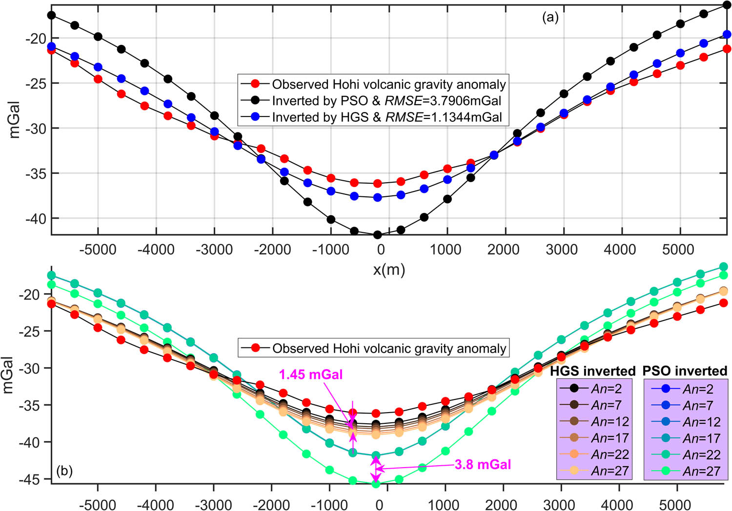
Inverted results of the profile A–B, Hohi volcanic zone, Kyushu, Japan: (a) fittings between the observed anomaly (red symbols with a black line) and the inverted mean responses of HGS and PSO (blue and black symbols with solid lines) and (b) yielded mean responses of HGS and PSO varying with An.
![Figure 17
Previous interpretive result of N–S profile of the Shishimuta caldera [18,103].](/document/doi/10.1515/geo-2022-0641/asset/graphic/j_geo-2022-0641_fig_017.jpg)
Another thing that needs to be clarified is that, as we can tell the differences from the theoretical tests and the field applications, PSO exhibited more erroneous performance in terms of larger fitting errors, higher inversion uncertainties, and lower robustness regarding the gravity responses that were generated by a multi-structure model. This is simply because the model parameters of multiple structures will enhance the non-uniqueness, non-linearity, and ill-posedness of the inversion process. However, HGS preserves its superiority of retrieving model parameters regardless of the complexity of the subsurface geological–geophysical settings.
9 Conclusions
Retrieving model parameters describing various subsurface structures from a precarious process due to the well-acknowledged non-uniqueness and ill-posedness of gravity inversion problems is the intrinsic aim in gravity data elucidation. We introduced a novel derivative-free nature-inspired global optimizer termed HGS and validated its superiority in determining model-describing parameters from gravity anomalies in detail. Prior to the implementation of HGS, modal analyses using error topography maps of model parameter pairs showed the non-linear and high-dimensional mathematical nature of the objective function tailored. To take precautions against these limitations, parameter-tuning studies were performed. With the tuned control parameters, HGS was applied to synthetically generated gravity anomalies and subsequently experimented on two field data examples from India and Japan for geothermal energy exploration and volcanic activity study. In addition, the effectiveness of implementing the SMA scheme to suppress the regional background was examined and certified with regard to the contaminated cases. PSO, the most commonly used global optimizer in geophysical inversions, was also unbiasedly applied to perform comparative experiments. Post-inversion uncertainty appraisal analyses were further implemented to understand the reliability of the model parameters obtained.
In general, simulated and field anomalies were more satisfactorily inverted with the HGS algorithm. The inverted outcomes of the HGS algorithm were well in line with the available geologic, geophysical, and/or drilling information. We conclude that the HGS optimizer is more efficient than PSO in balancing global exploration and the local exploitation processes in this type of geophysical inverse problems. This novel metaheuristic can, therefore, be considered as a promising alternative in geothermal reservoir identifications and volcanic activity studies.
Acknowledgements
We are grateful to the managing editor, Dr. Jan Barabach, the editor, Rita de Nardis, and two capable anonymous reviewers for their suggestions that greatly improved the quality of this manuscript. We also want to thank Prof. Yunus Levent Ekinci and Prof. Çağlayan Balkaya for helpful discussions during the revision process. This research was supported by China Nuclear Geology “Survey and evaluation exploration in the Xiangshan field and adjacent areas of Jiangxi Province of uranium resources” (No#2022-29), independent researcher project of Research institute No.270 #270202302.
-
Funding information: This research was funded by China Nuclear Geology “Survey and evaluation exploration in the Xiangshan field and adjacent areas of Jiangxi Province of uranium resources” (No#2022-29) and independent researcher project of Research institute No.270 #270202302.
-
Author contributions: All authors have contributed to the conceptualization of this research and computer implementation of the methods. K.J.S, H.A and A.A worked on the mathematical theory and manuscript preparation. C.L, X.W and Z.Q carried out the data selection and discussion. H.A, A.A, Y.T, Y.Y and T.N contributed to the revision process. All authors have read and agreed to the published version of the manuscript.
-
Conflict of interest: The authors state no conflicts of interest relevant to this study.
References
[1] Hinze WJ, Vonfrese R, Saad AH. Gravity and magnetic exploration, principles, practices, and applications by Hinze, vonFrese and Saad, 2013; Gravity and magnetic exploration, principles, practices, and applications by Hinze, vonFrese and Saad, 2013; 2013.10.1017/CBO9780511843129Search in Google Scholar
[2] Alvandi A, Su K, Ai H, Ardestani VE, Lyu C. Enhancement of potential field source boundaries using the hyperbolic domain (gudermannian function). Minerals. 2023;13(10):1312.10.3390/min13101312Search in Google Scholar
[3] Chen G, Liu T, Sun J, Cheng Q, Zhang H. Gravity method for investigating the geological structures associated with W-Sn polymetallic deposits in the Nanling Range, China. J Appl Geophys. 2015;120:14–25.10.1016/j.jappgeo.2015.06.001Search in Google Scholar
[4] Li Y, Melo A, Martinez C, Sun J. Geology differentiation: A new frontier in quantitative geophysical interpretation in mineral exploration. Lead Edge. 2019;38:60–6.10.1190/tle38010060.1Search in Google Scholar
[5] Essa KS, Abo-Ezz ER. Potential field data interpretation to detect the parameters of buried geometries by applying a nonlinear least-squares approach. Acta Geodaetica Geophys. 2021;56:387–406.10.1007/s40328-021-00337-5Search in Google Scholar
[6] Pašteka R, Pánisová J, Zahorec P, Papčo J, Mrlina J, Fraštia M, et al. Microgravity method in archaeological prospection: methodical comments on selected case studies from crypt and tomb detection. Archaeol Prospect. 2020;27:415–31.10.1002/arp.1787Search in Google Scholar
[7] Branston MW, Styles P. Site characterization and assessment using the microgravity technique: a case history. Surf Geophys. 2006;4:377–85.10.3997/1873-0604.2006011Search in Google Scholar
[8] Batayneh A, Khataibeh J, Alrshdan H, Tobasi U, Al㎎ahed N. The use of microgravity, magnetometry and resistivity surveys for the characterization and preservation of an archaeological site at Umm er-Rasas, Jordan. Archaeol Prospect. 2010;14:60–70.10.1002/arp.301Search in Google Scholar
[9] Sarlak B, Aghajani H. Archaeological investigations at Tepe Hissar-Damghan using Gravity and Magnetics methods. J Res Archaeometry. 2017;2(2):19–34.10.29252/jra.2.2.19Search in Google Scholar
[10] An Z, Di Q, Wang R, Wang M. Multi-geophysical investigation of geological structures in a pre-selected high-level radioactive waste disposal area in Northwestern China. J Environ Eng Geophysics. 2013;18(2):137–46.10.2113/JEEG18.2.137Search in Google Scholar
[11] Pašteka R, Hajach M, Brixová B, Mikuška J, Stanley J. Real magnetic stripping method in unexploded ordnance detection and remediation–a case study from Rohoznık military training range in SW Slovakia. Contributions Geophys Geodesy. 2021;51:277–94.10.31577/congeo.2021.51.3.5Search in Google Scholar
[12] Abedi M, Mosazadeh K, Dehghani H, Madanchizare A. AN-EUL method for automatic interpretation of potential field data in Unexploded Ordnances (UXO) detection. Shahrood University of Technology; 2014;5:67–77.Search in Google Scholar
[13] Yuan B, Song L, Hang L, An S, Zhang C. Gravity and magnetic field characteristics and hydrocarbon prospects of the Tobago Basin. Geophys Prospect. 2018;66(8):1586–601.10.1111/1365-2478.12594Search in Google Scholar
[14] Saghafi H, Yarveicy H. Gas hydrate stability conditions: Modeling on the basis of gas gravity approach. Pet Sci Technol. 2019;37:1–8.10.1080/10916466.2018.1463261Search in Google Scholar
[15] Casallas-Moreno KL, González-Escobar M, Gómez-Arias E, Mastache-Román EA, Gallegos-Castillo CA, González-Fernández A. Analysis of subsurface structures based on seismic and gravimetric exploration methods in the Las Tres Vírgenes volcanic complex and geothermal field, Baja California Sur, Mexico. Geothermics. 2021;92:102026.10.1016/j.geothermics.2020.102026Search in Google Scholar
[16] Altwegg P, Schill E, Abdelfettah Y, Radogna PV, Mauri G. Toward fracture porosity assessment by gravity forward modeling for geothermal exploration (Sankt Gallen, Switzerland). Geothermics. 2015;57:26–38.10.1016/j.geothermics.2015.05.006Search in Google Scholar
[17] Uwiduhaye JDA, Mizunaga H, Saibi H. Geophysical investigation using gravity data in Kinigi geothermal field, Northwest Rwanda. J Afr Earth Sci. 2018;139(Mar.):184–92.10.1016/j.jafrearsci.2017.12.016Search in Google Scholar
[18] Essa KS, Diab ZE. Source parameters estimation from gravity data using Bat algorithm with application to geothermal and volcanic activity studies. Int J Environ Sci Technol. 2022;20:1–21.10.1007/s13762-022-04263-zSearch in Google Scholar
[19] Pazzi V, Di Filippo M, Di Nezza M, Carlà T, Bardi F, Marini F, et al. Integrated geophysical survey in a sinkhole-prone area: Microgravity, electrical resistivity tomographies, and seismic noise measurements to delimit its extension. Eng Geol. 2018;243:282–93.10.1016/j.enggeo.2018.07.016Search in Google Scholar
[20] Abdullah FM, Al-Shuhail A, Sanuade OA. Characterization of subsurface cavities using gravity and ground penetrating radar. J Environ & Eng Geophysics. 2019;24:265–76.10.2113/JEEG24.2.265Search in Google Scholar
[21] Saddek B, Chemseddine F, Djamel B, Nabil B. Surface and subsurface investigations for the detection and mapping of underground karst cav. J Geol Soc India. 2019;93(2):228–34.10.1007/s12594-019-1157-1Search in Google Scholar
[22] Debeglia N, Dupont F. Some critical factors for engineering and environmental microgravity investigations. J Appl Geophys. 2002;50:435–54.10.1016/S0926-9851(02)00194-5Search in Google Scholar
[23] Arisona A, Nawawi M, Khalil AE, Abdulrahman A. Assessment of microgravity anomalies of soil structure for geotechnical 2D models. J Geosci Eng Environ Technol. 2018;3:151–4.10.24273/jgeet.2018.3.3.2058Search in Google Scholar
[24] Frédéric F, Guillaume R. Monitoring groundwater storage changes using the gravity recovery and climate experiment (GRACE) satellite mission: A review. Remote Sens. 2018;10:829.10.3390/rs10060829Search in Google Scholar
[25] Delobbe L, Watlet A, Wilfert S, Camp MV. Exploring the use of a superconducting gravimeter to evaluate radar estimates of heavy rainfall. Göttingen, Germany: Copernicus GmbH; 2018.10.5194/hess-2018-440Search in Google Scholar
[26] Silva JBC, Teixeira WA, Barbosa VCF. Gravity data as a tool for landfill study. Environ Geol. 2009;57(4):749.10.1007/s00254-008-1353-6Search in Google Scholar
[27] Dumont G, Robert T, Marck N, Nguyen F. Assessment of multiple geophysical techniques for the characterization of municipal waste deposit sites. J Appl Geophys. 2017;145:74–83.10.1016/j.jappgeo.2017.07.013Search in Google Scholar
[28] Roy A, Sharma RK, Jash D, Rao P, Dev JA, Tomson JK. Imaging of moho topography with conditional generative adversarial network from observed gravity anomalies. J Asian Earth Sci. 2024;265:106093.10.1016/j.jseaes.2024.106093Search in Google Scholar
[29] Oksum E. Grav3CH_inv: A GUI-based MATLAB code for estimating the 3-D basement depth structure of sedimentary basins with vertical and horizontal density variation. Computers Geosci. 2021;155:104856.10.1016/j.cageo.2021.104856Search in Google Scholar
[30] Deng Y, Chen Y, Wang P, Essa KS, Xu T, Liang X, et al. Magmatic underplating beneath the Emeishan large igneous province (South China) revealed by the COMGRA-ELIP experiment. Tectonophysics. 2016;672:16–23.10.1016/j.tecto.2016.01.039Search in Google Scholar
[31] Dibs H, Ali AH, Al-Ansari N, Abed SA. Fusion Landsat-8 thermal TIRS and OLI datasets for superior monitoring and change detection using remote sensing. Emerg Sci J. 2023;7(2):428–44.10.28991/ESJ-2023-07-02-09Search in Google Scholar
[32] Susilo A, Juwono AM, Aprilia F, Hisyam F, Rohmah S, Hasan MFR. Subsurface analysis using microtremor and resistivity to determine soil vulnerability and discovery of new local fault. Civ Eng J. 2023;9(9):2286–99.10.28991/CEJ-2023-09-09-014Search in Google Scholar
[33] Dibs H, Jaber HS, Al-Ansari N. Multi-fusion algorithms for detecting land surface pattern changes using multi-high spatial resolution images and remote sensing analysis. Emerg Sci J. 2023;7(4):1215–31.10.28991/ESJ-2023-07-04-013Search in Google Scholar
[34] Athens ND, Caers JK. Gravity inversion for geothermal exploration with uncertainty quantification. Geothermics. 2021;97:102230.10.1016/j.geothermics.2021.102230Search in Google Scholar
[35] Lichoro CM, Arnason K, Cumming W. Joint interpretation of gravity and resistivity data from the Northern Kenya volcanic rift zone: Structural and geothermal significance. Geothermics. 2018;77:139–50.10.1016/j.geothermics.2018.09.006Search in Google Scholar
[36] Zhdanov MS. Iterative solutions of the linear inverse problem – ScienceDirect. Methods Geochem Geophys. 2002;36:91–119.10.1016/S0076-6895(02)80041-5Search in Google Scholar
[37] Tarantola A Inverse problem theory and methods for model parameter estimation. Society for industrial and applied mathematics. Philadelphia, PA: Society for industrial and applied mathematics; 2005.10.1137/1.9780898717921Search in Google Scholar
[38] Sharma SP, Biswas A. Interpretation of self-potential anomaly over a 2D inclined structure using very fast simulated-annealing global optimization — An insight about ambiguity. Geophysics. 2013;78(3):WB3–15.10.1190/geo2012-0233.1Search in Google Scholar
[39] Mehanee SA, Essa KS. 2.5D regularized inversion for the interpretation of residual gravity data by a dipping thin sheet: numerical examples and case studies with an insight on sensitivity and non-uniqueness. Earth Planets Space. 2015;67:130.10.1186/s40623-015-0283-2Search in Google Scholar
[40] Essa KS, Abo-Ezz ER, Géraud Y, Diraison M. A full interpretation applying a metaheuristic particle swarm for gravity data of an active mud diapir, SW Taiwan. J Pet Sci Eng. 2022;215:110683.10.1016/j.petrol.2022.110683Search in Google Scholar
[41] Essa KS, Géraud Y, Diraison M. Fault parameters assessment from the gravity data profiles applying the global particle swarm optimization. J Pet Sci Eng. 2021;207:109129.10.1016/j.petrol.2021.109129Search in Google Scholar
[42] Telford WM, Geldart LP, Sheriff RE. Applied geophysics: Methods employing natural electrical sources. Cambridge: Cambridge University Press; 1990. p. 293–342.10.1017/CBO9781139167932.010Search in Google Scholar
[43] Abdelrahman E, El-Araby TM, Essa KS. Shape and depth solutions form third moving average residual gravity anomalies using the window curves method. Kuwait J Sci Eng. 2003;30:95–108.Search in Google Scholar
[44] Al-Garni MA. Walsh transforms for depth determination of a finite vertical cylinder from its residual gravity anomaly. In Proceedings of the Symposium on the Application of Geophysics to Engineering & Environmental Problems; 2008.10.4133/1.2963311Search in Google Scholar
[45] Asfahani J, Tlas M. Fair function minimization for direct interpretation of residual gravity anomaly profiles due to spheres and cylinders. Pure Appl Geophysics. 2012;169:157–65.10.1007/s00024-011-0319-xSearch in Google Scholar
[46] Abdelrahman EM, Essa KS. Three least-squares minimization approaches to interpret gravity data due to dipping faults. Pure Appl Geophys. 2015;172:427–38.10.1007/s00024-014-0861-4Search in Google Scholar
[47] Fedi M. DEXP: A fast method to determine the depth to the sources of potential fields. Geophysics. 2005;24:2668.10.1190/1.2144416Search in Google Scholar
[48] Ahmed AM, Maurizio F. Automatic dexp imaging of potential fields independent of the structural index. Geophys J Int. 2014;3:1625–32.10.1093/gji/ggu354Search in Google Scholar
[49] Alvandi A, Deniz Toktay H, Nasri S. Application of direct source parameter imaging (direct local wave number) technique to the 2D gravity anomalies for depth determination of some geological structures. Acta Geophys. 2022;70(2):659–67.10.1007/s11600-022-00750-6Search in Google Scholar
[50] Ekinci YL, Yiğitbaş E. Interpretation of gravity anomalies to delineate some structural features of Biga and Gelibolu peninsulas, and their surroundings (north-west Turkey). Geodinamica Acta. 2015;27(4):300–19.10.1080/09853111.2015.1046354Search in Google Scholar
[51] Hiramatsu Y, Sawada A, Kobayashi W, Ishida S, Hamada M. Gravity gradient tensor analysis to an active fault: a case study at the Togi-gawa Nangan fault, Noto Peninsula, central Japan. Earth Planets Space. 2019;71:107.10.1186/s40623-019-1088-5Search in Google Scholar
[52] Cooper G. Iterative Euler deconvolution. Explor Geophys. 2020;52:1–7.10.1080/08123985.2020.1834381Search in Google Scholar
[53] Balkaya Ç, Ekinci YL, Göktürkler G, Turan S. 3D non-linear inversion of magnetic anomalies caused by prismatic bodies using differential evolution algorithm. J Appl Geophysics. 2017;136:372–86.10.1016/j.jappgeo.2016.10.040Search in Google Scholar
[54] Biswas A. Interpretation of gravity and magnetic anomaly over thin sheet-type structure using very fast simulated annealing global optimization technique. Model Earth Syst Environ. 2016;2:1–12.10.1007/s40808-016-0082-1Search in Google Scholar
[55] Roy A, Dubey CP, Prasad M. Gravity inversion for heterogeneous sedimentary basin with b-spline polynomial approximation using differential evolution algorithm. Geophysics. 2021;86(3):F35–47.10.1190/geo2019-0779.1Search in Google Scholar
[56] Roy A, Kumar TS. Gravity inversion of 2D fault having variable density contrast using particle swarm optimization. Geophys Prospect. 2021;69(6):1358–74.10.1111/1365-2478.13094Search in Google Scholar
[57] Kaftan İ. Interpretation of magnetic anomalies using a genetic algorithm. Acta Geophys. 2017;65(4):627–34.10.1007/s11600-017-0060-7Search in Google Scholar
[58] Pallero JLG, Fernandez-Martinez JL, Bonvalot S, Fudym O. 3D gravity inversion and uncertainty assessment of basement relief via Particle Swarm Optimization. J Appl Geophys. 2017;139:338–50.10.1016/j.jappgeo.2017.02.004Search in Google Scholar
[59] Essa KS, Munschy M. Gravity data interpretation using the particle swarm optimisation method with application to mineral exploration. Heidelberg, Germany: Journal of Earth System Science; 2019.10.1007/s12040-019-1143-4Search in Google Scholar
[60] Essa KS, Géraud Y. Parameters estimation from the gravity anomaly caused by the two-dimensional horizontal thin sheet applying the global particle swarm algorithm. J Pet Sci Eng. 2020;193:107421.10.1016/j.petrol.2020.107421Search in Google Scholar
[61] Liu S, Hu X, Zhang H, Geng M, Zuo B. 3D magnetization vector inversion of magnetic data: Improving and comparing methods. Pure Appl Geophys. 2017;174:4421–44.10.1007/s00024-017-1654-3Search in Google Scholar
[62] Rathee N, Chhillar RS. Gravitational search algorithm: A novel approach for structural test path optimizationl. J Interdiscip Math. 2020;23:471.10.1080/09720502.2020.1731960Search in Google Scholar
[63] Pace F, Santilano A, Godio A. A review of geophysical modeling based on particle swarm optimization. Surv Geophys. 2021;42:505–49.10.1007/s10712-021-09638-4Search in Google Scholar PubMed PubMed Central
[64] Alkan H, Balkaya Ç. Parameter estimation by Differential Search Algorithm from horizontal loop electromagnetic (HLEM) data. J Appl Geophys. 2018;149:77–94.10.1016/j.jappgeo.2017.12.016Search in Google Scholar
[65] Ben UC, Ekwok SE, Akpan AE, Mbonu CC, Eldosouky AM, Abdelrahman K, et al. Interpretation of Magnetic Anomalies by Simple Geometrical Structures Using the Manta-Ray Foraging Optimization. Front Earth Sci. 2022;10:849079.10.3389/feart.2022.849079Search in Google Scholar
[66] Ai H, Ekinci YL, Balkaya Ç, Alvandi A, Ekinci R, Roy A, et al. Modified Barnacles mating optimizing algorithm for the inversion of self-potential anomalies due to ore deposits. Nat Resour Res. 2024;33:1–30.10.1007/s11053-024-10331-7Search in Google Scholar
[67] Simirdanis K, Simon F-X, Oikonomou D, Papadoupoulos N. A Short Literature on Joint Inversion Methods in Geophysics IMS FORTH; Inrap-DST; 2019.Search in Google Scholar
[68] Tarantola A, Valette B. Inverse problems = quest for information. J geophysics. 1982;50(1):159–70.Search in Google Scholar
[69] Menke W. Geophysical data analysis: Discrete inverse theory. Cambridge, Massachusetts: Academic Press; 2018.Search in Google Scholar
[70] De Nardis R, Cardarelli E, Dobróka M. Quasi-2D hybrid joint inversion of seismic and geoelectric data. Geophys Prospecting. 2005;53(5):705–16.10.1111/j.1365-2478.2005.00497.xSearch in Google Scholar
[71] Dobróka M, Gyulai Á, Ormos T, Csókás J, Dresen L. Joint inversion of seismic and geoelectric data recorded in an underground coal mine 1. Geophys Prospecting. 1991;39(5):643–65.10.1111/j.1365-2478.1991.tb00334.xSearch in Google Scholar
[72] Hu B, Wen L, Zhou X. Joint inversion of VES and Rayleigh wave data based on improved DE algorithm for near surface exploration. World J Eng. 2024;21(2):242–53.10.1108/WJE-05-2022-0193Search in Google Scholar
[73] Scarponi M, Hetényi G, Plomerová J, Solarino S, Baron L, Petri B. Joint seismic and gravity data inversion to image intra-crustal structures: the Ivrea Geophysical Body along the Val Sesia profile (Piedmont, Italy). Front Earth Sci. 2021;9:671412.10.3389/feart.2021.671412Search in Google Scholar
[74] Ai H, Ekinci YL, Balkaya Ç, Essa KS. Inversion of geomagnetic anomalies caused by ore masses using hunger games search algorithm. Earth Space Sci. 2023;10(11):e2023EA003002. 10.1029/2023EA003002.Search in Google Scholar
[75] Ai H, Li H, Essa KS, Ekinci YL, Balkaya Ç. Global optimization of self-potential anomalies using hunger games search algorithm. Pure Appl Geophys. 2024;181:1–34.10.1007/s00024-024-03457-5Search in Google Scholar
[76] Gupta OP. A least-squares approach to depth determination from gravity data. Geophysics. 1983;48:357–60.10.1190/1.1441473Search in Google Scholar
[77] Abdelrahman E, Abo-Ezz E, Essa K, El-Araby T, Soliman K. A least-squares variance analysis method for shape and depth estimation from gravity data. J Geophys Eng. 2006;3:143.10.1088/1742-2132/3/2/005Search in Google Scholar
[78] Ai H, Essa KS, Ekinci YL, Balkaya Ç, Li H, Géraud Y. Magnetic anomaly inversion through the novel barnacles mating optimization algorithm. Sci Rep. 2022;12:22578.10.1038/s41598-022-26265-0Search in Google Scholar PubMed PubMed Central
[79] Yang Y, Chen H, Heidari AA, Gandomi AH. Hunger games search: Visions, conception, implementation, deep analysis, perspectives, and towards performance shifts. Expert Syst Appl. 2021;177:114864.10.1016/j.eswa.2021.114864Search in Google Scholar
[80] Essa KS, Mehanee SA, Elhussein M. Gravity data interpretation by a two-sided fault-like geologic structure using the global particle swarm technique. Phys Earth Planet Inter. 2020;311:106631.10.1016/j.pepi.2020.106631Search in Google Scholar
[81] Balkaya A, Kaftan I. Inverse modelling via differential search algorithm for interpreting magnetic anomalies caused by 2D dyke-shaped bodies. J Earth Syst Sci. 2021;130:1–23.10.1007/s12040-021-01614-1Search in Google Scholar
[82] Ekinci YL, Balkaya G, Ktürkler G, Turan S. Model parameter estimations from residual gravity anomalies due to simple-shaped sources using Differential Evolution Algorithm. J Appl Geophys. 2016;129:133–47.10.1016/j.jappgeo.2016.03.040Search in Google Scholar
[83] Deb K, Gupta H. Introducing robustness in multi-objective optimization. Evolut Comput. 2014;14:463–94.10.1162/evco.2006.14.4.463Search in Google Scholar PubMed
[84] Ray T. Constrained robust optimal design using a multiobjective evolutionary algorithm. Congress on Evolutionary Computation. IEEE; 2002.Search in Google Scholar
[85] Mirjalili S, Lewis A. Obstacles and difficulties for robust benchmark problems: A novel penalty-based robust optimisation method. Inf Sci. 2012;328:485–509.10.1016/j.ins.2015.08.041Search in Google Scholar
[86] Ekinci YL, Balkaya A, Gktürkler G. Correction to: Backtracking search optimization: A novel global optimization algorithm for the inversion of gravity anomalies. Pure Appl Geophys. 2021;178:4687.10.1007/s00024-021-02891-zSearch in Google Scholar
[87] Carlisle A, Dozier G. An off-the-shelf PSO. Proceedings of the Workshop on Particle Swarm Optimization. Indianapolis, USA: 2001. p. 1–6.Search in Google Scholar
[88] Kennedy J, Eberhart R. Particle swarm optimization. Proceedings of ICNN'95-International Conference on Neural Networks. IEEE; 1995. p. 1942–8.10.1109/ICNN.1995.488968Search in Google Scholar
[89] Trelea IC. The particle swarm optimization algorithm: convergence analysis and parameter selection. Inf Process Lett. 2003;85(6):317–25.10.1016/S0020-0190(02)00447-7Search in Google Scholar
[90] Jiang M, Luo YP, Yang SY. Stochastic convergence analysis and parameter selection of the standard particle swarm optimization algorithm. Inf Process Lett. 2007;102(1):8–16.10.1016/j.ipl.2006.10.005Search in Google Scholar
[91] Santos FAM. Inversion of self-potential of idealized bodies’ anomalies using particle swarm optimization. Computers Geosci. 2010;36(9):1185–90.10.1016/j.cageo.2010.01.011Search in Google Scholar
[92] Clerc M, Kennedy J. The particle swarm-explosion, stability, and convergence in a multidimensional complex space. IEEE Trans Evolut Comput. 2002;6(1):58–73.10.1109/4235.985692Search in Google Scholar
[93] Eberhart RC, Shi Y. Comparing inertia weights and constriction factors in particle swarm optimization. Proceedings of the 2000 Congress on Evolutionary Computation. CEC00 (Cat. No. 00TH8512). IEEE; 2000. p. 84–8.10.1109/CEC.2000.870279Search in Google Scholar
[94] Schutte JF, Groenwold AA. A study of global optimization using particle swarms. J Glob Optim. 2005;31:93–108.10.1007/s10898-003-6454-xSearch in Google Scholar
[95] Martínez JLF, Gonzalo EG, Álvarez JPF. PSO: A powerful algorithm to solve geophysical inverse problems: Application to a 1D-DC resistivity case. J Appl Geophys. 2010;71(1):13–25.10.1016/j.jappgeo.2010.02.001Search in Google Scholar
[96] Ai H, Alvandi A, Ghanati R, Pham L, Alarifi S, Nasui D, et al. Modified non-local means: A novel denoising approach to process gravity field data. Open Geosci. 2023;15(1):20220551. 10.1515/geo-2022-0551.Search in Google Scholar
[97] Sukeshwala RN, Sethna SF. Layered gabbro of composite plug of Phenaimata, Gujarat State. J Geol Soc India. 1969;10:177–87.Search in Google Scholar
[98] Hari KR, Rao N, Swarnkar V, Hou G. Alkali feldspar syenites with shoshonitic affinities from Chhotaudepur area: Implication for mantle metasomatism in the Deccan large igneous province. Geosci Front. 2014;5:261–76.10.1016/j.gsf.2013.06.007Search in Google Scholar
[99] Basu AR, Poreda RJ, Renne PR, Teichmann F, Turrin BD. High-3He plume origin and temporal-spatial evolution of the Siberian flood Basalts. Science. 1995;269:822–5.10.1126/science.269.5225.822Search in Google Scholar PubMed
[100] Rao G, Rao JM, Lakshmi K. Palaeomagnetic study of the alkaline rocks associated with the Deccan traps of Northwestern India. Hyderabad, India: Indian Journal of Geochemistry; 2004.Search in Google Scholar
[101] Singh B, Rao M, Prajapati SK, Swarnapriya C. Combined gravity and magnetic modeling over Pavagadh and Phenaimata igneous complexes, Gujarat, India: Inference on emplacement history of Deccan volcanism. J Asian Earth Sci. 2014;80(Feb. 5):119–33.10.1016/j.jseaes.2013.11.005Search in Google Scholar
[102] Krishnamurthy P, Gopalan K, Macdougall JD. Olivine compositions in Picrite Basalts and the Deccan Volcanic cycle. J Pet. 2000;1057–69.10.1093/petrology/41.7.1057Search in Google Scholar
[103] Kamata H. Shishimuta caldera, the buried source of the Yabakei pyroclastic flow in the Hohi volcanic zone, Japan. Bull Volcanol. 1989;51:41–50.10.1007/BF01086760Search in Google Scholar
[104] Kamata H. Volcanic and structural history of the Hohi volcanic zone, central Kyushu, Japan. Bull Volcanol. 1989;51:315–32.10.1007/BF01056894Search in Google Scholar
[105] Aramaki S. Formation of the Aira Caldera, southern Kyushu, ∼22,000 years ago. J Geophys Res. 1984;89:8485–501.10.1029/JB089iB10p08485Search in Google Scholar
[106] Sasada M. Basement structure of the Hohi area, Central Kyushu, Japan. J Jpn Geotherm Energy Assoc. 1984;21:1–11.Search in Google Scholar
[107] Tamanyu S. Stratigraphy and geological structures of the Hohi geothermal area, based mainly on borehole data. Reports Geol Surv Jpn. 1985;264:115–42 (in Japanese).Search in Google Scholar
[108] MITI (Ministry of International Trade and Industry). Report on the confirmation study of the effectiveness of prospecting for deep geothermal resources integrated analyses (3rd ver). Ministry International Trade Industry; 1986. p. 1–151 (in Japanese).Search in Google Scholar
[109] Komazawa M, Kamata H. The basement structure of the Hohi geothermal area obtained by gravimetric analysis in central-north Kyushu, Japan. Tsukuba, Ibaraki Prefecture, Japan: Geological Survey of Japan; 1985.Search in Google Scholar
© 2024 the author(s), published by De Gruyter
This work is licensed under the Creative Commons Attribution 4.0 International License.
Articles in the same Issue
- Regular Articles
- Theoretical magnetotelluric response of stratiform earth consisting of alternative homogeneous and transitional layers
- The research of common drought indexes for the application to the drought monitoring in the region of Jin Sha river
- Evolutionary game analysis of government, businesses, and consumers in high-standard farmland low-carbon construction
- On the use of low-frequency passive seismic as a direct hydrocarbon indicator: A case study at Banyubang oil field, Indonesia
- Water transportation planning in connection with extreme weather conditions; case study – Port of Novi Sad, Serbia
- Zircon U–Pb ages of the Paleozoic volcaniclastic strata in the Junggar Basin, NW China
- Monitoring of mangrove forests vegetation based on optical versus microwave data: A case study western coast of Saudi Arabia
- Microfacies analysis of marine shale: A case study of the shales of the Wufeng–Longmaxi formation in the western Chongqing, Sichuan Basin, China
- Multisource remote sensing image fusion processing in plateau seismic region feature information extraction and application analysis – An example of the Menyuan Ms6.9 earthquake on January 8, 2022
- Identification of magnetic mineralogy and paleo-flow direction of the Miocene-quaternary volcanic products in the north of Lake Van, Eastern Turkey
- Impact of fully rotating steel casing bored pile on adjacent tunnels
- Adolescents’ consumption intentions toward leisure tourism in high-risk leisure environments in riverine areas
- Petrogenesis of Jurassic granitic rocks in South China Block: Implications for events related to subduction of Paleo-Pacific plate
- Differences in urban daytime and night block vitality based on mobile phone signaling data: A case study of Kunming’s urban district
- Random forest and artificial neural network-based tsunami forests classification using data fusion of Sentinel-2 and Airbus Vision-1 satellites: A case study of Garhi Chandan, Pakistan
- Integrated geophysical approach for detection and size-geometry characterization of a multiscale karst system in carbonate units, semiarid Brazil
- Spatial and temporal changes in ecosystem services value and analysis of driving factors in the Yangtze River Delta Region
- Deep fault sliding rates for Ka-Ping block of Xinjiang based on repeating earthquakes
- Improved deep learning segmentation of outdoor point clouds with different sampling strategies and using intensities
- Platform margin belt structure and sedimentation characteristics of Changxing Formation reefs on both sides of the Kaijiang-Liangping trough, eastern Sichuan Basin, China
- Enhancing attapulgite and cement-modified loess for effective landfill lining: A study on seepage prevention and Cu/Pb ion adsorption
- Flood risk assessment, a case study in an arid environment of Southeast Morocco
- Lower limits of physical properties and classification evaluation criteria of the tight reservoir in the Ahe Formation in the Dibei Area of the Kuqa depression
- Evaluation of Viaducts’ contribution to road network accessibility in the Yunnan–Guizhou area based on the node deletion method
- Permian tectonic switch of the southern Central Asian Orogenic Belt: Constraints from magmatism in the southern Alxa region, NW China
- Element geochemical differences in lower Cambrian black shales with hydrothermal sedimentation in the Yangtze block, South China
- Three-dimensional finite-memory quasi-Newton inversion of the magnetotelluric based on unstructured grids
- Obliquity-paced summer monsoon from the Shilou red clay section on the eastern Chinese Loess Plateau
- Classification and logging identification of reservoir space near the upper Ordovician pinch-out line in Tahe Oilfield
- Ultra-deep channel sand body target recognition method based on improved deep learning under UAV cluster
- New formula to determine flyrock distance on sedimentary rocks with low strength
- Assessing the ecological security of tourism in Northeast China
- Effective reservoir identification and sweet spot prediction in Chang 8 Member tight oil reservoirs in Huanjiang area, Ordos Basin
- Detecting heterogeneity of spatial accessibility to sports facilities for adolescents at fine scale: A case study in Changsha, China
- Effects of freeze–thaw cycles on soil nutrients by soft rock and sand remodeling
- Vibration prediction with a method based on the absorption property of blast-induced seismic waves: A case study
- A new look at the geodynamic development of the Ediacaran–early Cambrian forearc basalts of the Tannuola-Khamsara Island Arc (Central Asia, Russia): Conclusions from geological, geochemical, and Nd-isotope data
- Spatio-temporal analysis of the driving factors of urban land use expansion in China: A study of the Yangtze River Delta region
- Selection of Euler deconvolution solutions using the enhanced horizontal gradient and stable vertical differentiation
- Phase change of the Ordovician hydrocarbon in the Tarim Basin: A case study from the Halahatang–Shunbei area
- Using interpretative structure model and analytical network process for optimum site selection of airport locations in Delta Egypt
- Geochemistry of magnetite from Fe-skarn deposits along the central Loei Fold Belt, Thailand
- Functional typology of settlements in the Srem region, Serbia
- Hunger Games Search for the elucidation of gravity anomalies with application to geothermal energy investigations and volcanic activity studies
- Addressing incomplete tile phenomena in image tiling: Introducing the grid six-intersection model
- Evaluation and control model for resilience of water resource building system based on fuzzy comprehensive evaluation method and its application
- MIF and AHP methods for delineation of groundwater potential zones using remote sensing and GIS techniques in Tirunelveli, Tenkasi District, India
- New database for the estimation of dynamic coefficient of friction of snow
- Measuring urban growth dynamics: A study in Hue city, Vietnam
- Comparative models of support-vector machine, multilayer perceptron, and decision tree predication approaches for landslide susceptibility analysis
- Experimental study on the influence of clay content on the shear strength of silty soil and mechanism analysis
- Geosite assessment as a contribution to the sustainable development of Babušnica, Serbia
- Using fuzzy analytical hierarchy process for road transportation services management based on remote sensing and GIS technology
- Accumulation mechanism of multi-type unconventional oil and gas reservoirs in Northern China: Taking Hari Sag of the Yin’e Basin as an example
- TOC prediction of source rocks based on the convolutional neural network and logging curves – A case study of Pinghu Formation in Xihu Sag
- A method for fast detection of wind farms from remote sensing images using deep learning and geospatial analysis
- Spatial distribution and driving factors of karst rocky desertification in Southwest China based on GIS and geodetector
- Physicochemical and mineralogical composition studies of clays from Share and Tshonga areas, Northern Bida Basin, Nigeria: Implications for Geophagia
- Geochemical sedimentary records of eutrophication and environmental change in Chaohu Lake, East China
- Research progress of freeze–thaw rock using bibliometric analysis
- Mixed irrigation affects the composition and diversity of the soil bacterial community
- Examining the swelling potential of cohesive soils with high plasticity according to their index properties using GIS
- Geological genesis and identification of high-porosity and low-permeability sandstones in the Cretaceous Bashkirchik Formation, northern Tarim Basin
- Usability of PPGIS tools exemplified by geodiscussion – a tool for public participation in shaping public space
- Efficient development technology of Upper Paleozoic Lower Shihezi tight sandstone gas reservoir in northeastern Ordos Basin
- Assessment of soil resources of agricultural landscapes in Turkestan region of the Republic of Kazakhstan based on agrochemical indexes
- Evaluating the impact of DEM interpolation algorithms on relief index for soil resource management
- Petrogenetic relationship between plutonic and subvolcanic rocks in the Jurassic Shuikoushan complex, South China
- A novel workflow for shale lithology identification – A case study in the Gulong Depression, Songliao Basin, China
- Characteristics and main controlling factors of dolomite reservoirs in Fei-3 Member of Feixianguan Formation of Lower Triassic, Puguang area
- Impact of high-speed railway network on county-level accessibility and economic linkage in Jiangxi Province, China: A spatio-temporal data analysis
- Estimation model of wild fractional vegetation cover based on RGB vegetation index and its application
- Lithofacies, petrography, and geochemistry of the Lamphun oceanic plate stratigraphy: As a record of the subduction history of Paleo-Tethys in Chiang Mai-Chiang Rai Suture Zone of Thailand
- Structural features and tectonic activity of the Weihe Fault, central China
- Application of the wavelet transform and Hilbert–Huang transform in stratigraphic sequence division of Jurassic Shaximiao Formation in Southwest Sichuan Basin
- Structural detachment influences the shale gas preservation in the Wufeng-Longmaxi Formation, Northern Guizhou Province
- Distribution law of Chang 7 Member tight oil in the western Ordos Basin based on geological, logging and numerical simulation techniques
- Evaluation of alteration in the geothermal province west of Cappadocia, Türkiye: Mineralogical, petrographical, geochemical, and remote sensing data
- Numerical modeling of site response at large strains with simplified nonlinear models: Application to Lotung seismic array
- Quantitative characterization of granite failure intensity under dynamic disturbance from energy standpoint
- Characteristics of debris flow dynamics and prediction of the hazardous area in Bangou Village, Yanqing District, Beijing, China
- Rockfall mapping and susceptibility evaluation based on UAV high-resolution imagery and support vector machine method
- Statistical comparison analysis of different real-time kinematic methods for the development of photogrammetric products: CORS-RTK, CORS-RTK + PPK, RTK-DRTK2, and RTK + DRTK2 + GCP
- Hydrogeological mapping of fracture networks using earth observation data to improve rainfall–runoff modeling in arid mountains, Saudi Arabia
- Petrography and geochemistry of pegmatite and leucogranite of Ntega-Marangara area, Burundi, in relation to rare metal mineralisation
- Prediction of formation fracture pressure based on reinforcement learning and XGBoost
- Hazard zonation for potential earthquake-induced landslide in the eastern East Kunlun fault zone
- Monitoring water infiltration in multiple layers of sandstone coal mining model with cracks using ERT
- Study of the patterns of ice lake variation and the factors influencing these changes in the western Nyingchi area
- Productive conservation at the landslide prone area under the threat of rapid land cover changes
- Sedimentary processes and patterns in deposits corresponding to freshwater lake-facies of hyperpycnal flow – An experimental study based on flume depositional simulations
- Study on time-dependent injectability evaluation of mudstone considering the self-healing effect
- Detection of objects with diverse geometric shapes in GPR images using deep-learning methods
- Behavior of trace metals in sedimentary cores from marine and lacustrine environments in Algeria
- Spatiotemporal variation pattern and spatial coupling relationship between NDVI and LST in Mu Us Sandy Land
- Formation mechanism and oil-bearing properties of gravity flow sand body of Chang 63 sub-member of Yanchang Formation in Huaqing area, Ordos Basin
- Diagenesis of marine-continental transitional shale from the Upper Permian Longtan Formation in southern Sichuan Basin, China
- Vertical high-velocity structures and seismic activity in western Shandong Rise, China: Case study inspired by double-difference seismic tomography
- Spatial coupling relationship between metamorphic core complex and gold deposits: Constraints from geophysical electromagnetics
- Disparities in the geospatial allocation of public facilities from the perspective of living circles
- Research on spatial correlation structure of war heritage based on field theory. A case study of Jinzhai County, China
- Formation mechanisms of Qiaoba-Zhongdu Danxia landforms in southwestern Sichuan Province, China
- Magnetic data interpretation: Implication for structure and hydrocarbon potentiality at Delta Wadi Diit, Southeastern Egypt
- Deeply buried clastic rock diagenesis evolution mechanism of Dongdaohaizi sag in the center of Junggar fault basin, Northwest China
- Application of LS-RAPID to simulate the motion of two contrasting landslides triggered by earthquakes
- The new insight of tectonic setting in Sunda–Banda transition zone using tomography seismic. Case study: 7.1 M deep earthquake 29 August 2023
- The critical role of c and φ in ensuring stability: A study on rockfill dams
- Evidence of late quaternary activity of the Weining-Shuicheng Fault in Guizhou, China
- Extreme hydroclimatic events and response of vegetation in the eastern QTP since 10 ka
- Spatial–temporal effect of sea–land gradient on landscape pattern and ecological risk in the coastal zone: A case study of Dalian City
- Study on the influence mechanism of land use on carbon storage under multiple scenarios: A case study of Wenzhou
- A new method for identifying reservoir fluid properties based on well logging data: A case study from PL block of Bohai Bay Basin, North China
- Comparison between thermal models across the Middle Magdalena Valley, Eastern Cordillera, and Eastern Llanos basins in Colombia
- Mineralogical and elemental analysis of Kazakh coals from three mines: Preliminary insights from mode of occurrence to environmental impacts
- Chlorite-induced porosity evolution in multi-source tight sandstone reservoirs: A case study of the Shaximiao Formation in western Sichuan Basin
- Predicting stability factors for rotational failures in earth slopes and embankments using artificial intelligence techniques
- Origin of Late Cretaceous A-type granitoids in South China: Response to the rollback and retreat of the Paleo-Pacific plate
- Modification of dolomitization on reservoir spaces in reef–shoal complex: A case study of Permian Changxing Formation, Sichuan Basin, SW China
- Geological characteristics of the Daduhe gold belt, western Sichuan, China: Implications for exploration
- Rock physics model for deep coal-bed methane reservoir based on equivalent medium theory: A case study of Carboniferous-Permian in Eastern Ordos Basin
- Enhancing the total-field magnetic anomaly using the normalized source strength
- Shear wave velocity profiling of Riyadh City, Saudi Arabia, utilizing the multi-channel analysis of surface waves method
- Effect of coal facies on pore structure heterogeneity of coal measures: Quantitative characterization and comparative study
- Inversion method of organic matter content of different types of soils in black soil area based on hyperspectral indices
- Detection of seepage zones in artificial levees: A case study at the Körös River, Hungary
- Tight sandstone fluid detection technology based on multi-wave seismic data
- Characteristics and control techniques of soft rock tunnel lining cracks in high geo-stress environments: Case study of Wushaoling tunnel group
- Influence of pore structure characteristics on the Permian Shan-1 reservoir in Longdong, Southwest Ordos Basin, China
- Study on sedimentary model of Shanxi Formation – Lower Shihezi Formation in Da 17 well area of Daniudi gas field, Ordos Basin
- Multi-scenario territorial spatial simulation and dynamic changes: A case study of Jilin Province in China from 1985 to 2030
- Review Articles
- Major ascidian species with negative impacts on bivalve aquaculture: Current knowledge and future research aims
- Prediction and assessment of meteorological drought in southwest China using long short-term memory model
- Communication
- Essential questions in earth and geosciences according to large language models
- Erratum
- Erratum to “Random forest and artificial neural network-based tsunami forests classification using data fusion of Sentinel-2 and Airbus Vision-1 satellites: A case study of Garhi Chandan, Pakistan”
- Special Issue: Natural Resources and Environmental Risks: Towards a Sustainable Future - Part I
- Spatial-temporal and trend analysis of traffic accidents in AP Vojvodina (North Serbia)
- Exploring environmental awareness, knowledge, and safety: A comparative study among students in Montenegro and North Macedonia
- Determinants influencing tourists’ willingness to visit Türkiye – Impact of earthquake hazards on Serbian visitors’ preferences
- Application of remote sensing in monitoring land degradation: A case study of Stanari municipality (Bosnia and Herzegovina)
- Optimizing agricultural land use: A GIS-based assessment of suitability in the Sana River Basin, Bosnia and Herzegovina
- Assessing risk-prone areas in the Kratovska Reka catchment (North Macedonia) by integrating advanced geospatial analytics and flash flood potential index
- Analysis of the intensity of erosive processes and state of vegetation cover in the zone of influence of the Kolubara Mining Basin
- GIS-based spatial modeling of landslide susceptibility using BWM-LSI: A case study – city of Smederevo (Serbia)
- Geospatial modeling of wildfire susceptibility on a national scale in Montenegro: A comparative evaluation of F-AHP and FR methodologies
- Geosite assessment as the first step for the development of canyoning activities in North Montenegro
- Urban geoheritage and degradation risk assessment of the Sokograd fortress (Sokobanja, Eastern Serbia)
- Multi-hazard modeling of erosion and landslide susceptibility at the national scale in the example of North Macedonia
- Understanding seismic hazard resilience in Montenegro: A qualitative analysis of community preparedness and response capabilities
- Forest soil CO2 emission in Quercus robur level II monitoring site
- Characterization of glomalin proteins in soil: A potential indicator of erosion intensity
- Power of Terroir: Case study of Grašac at the Fruška Gora wine region (North Serbia)
- Special Issue: Geospatial and Environmental Dynamics - Part I
- Qualitative insights into cultural heritage protection in Serbia: Addressing legal and institutional gaps for disaster risk resilience