Characterization of glomalin proteins in soil: A potential indicator of erosion intensity
-
Branislav Jović
 ,
Danica Jović
,
Danica Jović

Abstract
In this study, in a pioneering effort, glomalin proteins were extracted and geochemically characterized from soil in Serbia. Standard chemical (dry combustion, Walkley-Black) and spectroscopic methods (fourier transform infrared spectroscopy (FTIR), dynamic light scattering (DLS), scanning electron microscope (SEM)) were used to gain insight into the glomalin proteins. Samples from the City of Novi Sad (Serbia) were used for characterization and comparison. The soil contained an average of 17 mg/g of glomalin, representing ≈21% of the soil organic matter. DLS zeta potential analysis and the FTIR spectra reveal two significant differences before and after glomalin extraction, indicating a relationship between sand fractions and organic matter that affects particle aggregation and erosion potential. A comparison of SEM images and DLS results reveals that the glomalin extract consists of two particle size groups (0.08–1 and 6 µm), suggesting that the extraction process isolates only a smaller fraction of proteins and less tightly bound particles, indicating that soil aggregation is influenced by both mineralogy and the characteristics of organic matter. Hence, our research raises important questions about the role of glomalin in mitigating soil degradation processes, particularly soil erosion. Our study will enhance the overall understanding of glomalin, inspire future research, and prove beneficial for the sustainable restoration of degraded lands.
1 Introduction
Soil erosion is a pressing global issue that poses serious threats to agriculture, food security, and ecosystem health. The progressive loss of fertile topsoil not only undermines agricultural productivity but also disrupts vital ecological processes, jeopardizing the ability to sustain livelihoods and maintain biodiversity [1,2,3,4]. The studies of soils from various locations and under different management practices have revealed both the widespread occurrence and notably strong stability of glomalin proteins. Notably, a consistently strong positive correlation has been observed between the glomalin content and the strength and resistance of soil aggregates to erosion [5,6]. Furthermore, other studies have recognized the contributions of glomalin to carbon sequestration processes [5]. However, only a few studies have investigated the responsiveness of glomalin to alterations in the soil environment due to soil degradation. For example, Šarapatka et al. [7] showed the potential use of glomalin values to identify changes in soil properties during degradation/erosion. Their study utilized 48 localities in erosion-threatened areas of Southern Moravia in the Czech Republic. Vaidya et al. [5] performed an in-depth analysis of the quantity of glomalin in these soils and concluded that it increases with an escalation in the degree of interdependence between plants and arbuscular mycorrhizal fungi (AMF). Other authors outlined the potential of glomalin in soil erosion studies. Kumar et al. [8] studied the distribution of soil organic carbon (SOC) and glomalin-related soil protein (GRSP) in a reclaimed coal mine-land chronosequence. Their research underscored the significance of employing GRSPs and various fractions of SOC in landscapes affected by mining. A contemporary study by Kumar et al. [8] showed that soil amelioration using beneficial microorganisms that produce glomalin can benefit sustainable agricultural practices. They suggested that glomalin enhances soil physical properties, contributes to carbon sequestration, boosts nutrient levels, promotes microbial activities, stabilizes pollutants, and may ultimately facilitate the ecological restoration of degraded lands [9]. As pointed out by Lin et al. [10], the soil represents the most extensive terrestrial carbon (C) reservoir, holding approximately 1,500 Gt (gigatons) of C. This amount is at least equivalent to the combined carbon content of vegetation (∼560 Gt) and the atmosphere (∼750 Gt). Therefore, Khursheed [11] regarded glomalin as a key factor in soil carbon sequestration, where the interaction between robust and enduring root systems and their associated fungal threads plays a significant role in this process.
Additionally, the sorption properties of glomalin and the influence on the bioavailability of PAHs [12,13] and heavy metals [14] have been the subject of recent research. Certainly, a very interesting hypothesis and result were presented in a article dealing with the addition of CO2 and N2 and the examination of the sequestration potential of GSPR [15]. In this research, analysis of GRSP extracts provided useful information about the character of these complex and very important mixtures of organic matter. Samples of soil were characterized before and after several different extractions, in order to observe the chemical and morphological differences of the main constituents of the GRSP extracts (glomalin proteins and humic acids). This methodological step might be of great importance for conceptualizing soil erosion mitigation measures, by determining the amount of glomalin in soils.
The main objective of our study is to demonstrate that glomalin can reveal the correlation between sand fractions and glomalin-type organic matter fractions, which are key factors influencing particle aggregation and erosion susceptibility. Thus, our research paves the way for broader applications of glomalin in soil erosion studies, particularly in the context of sustainable land management and restoration efforts.
2 Materials and methods
2.1 Study area
The study area is located in the southern part of the Pannonian Plain along the Danube River. The Novi Sad region (North Serbia) is predominantly covered by Holocene alluvial deposits, which have formed through the fluvial activity of the Danube River and are characterized by a variety of grain-size textures. This terrace consists of Holocene sand shoals, sandy clay, and sand. The meandering of the Danube River has created typical fluvial morphology, featuring numerous point bars and associated depressions. The entire Novi Sad area lies on a fluvial terrace with an elevation of 72–80 meters above sea level (latitude 45°15′N; longitude 19°50′E). The area is characterized by the Cfb temperate climate, featuring a mean air temperature of 0.2°C in January, 21.9°C in July, and an annual mean air temperature of 11.4°C. The average annual precipitation amount is 647 mm. The indigenous soil type is classified as fluvisol according to the World Reference Base for Soil Resources and is predominantly formed on loamy substrates [16].
Climate and precipitation patterns are key factors influencing erosion trends. In the work of Malinović-Milićević et al. [17], it was pointed out that the climate in northern and central Vojvodina (northern Serbia) is experiencing an increase in both the magnitude and frequency of precipitation events. This trend is typical of much of central Europe. As reported by Micić Ponjiger et al. [2], seasonal variability in rainfall erosivity (RE) is significant for the study area. Summer records the highest mean RE values (600–700 MJ mm ha−1 h−1), followed by spring (300–400 MJ mm ha−1 h−1), autumn (200–300 MJ mm ha−1 h−1), and winter (100–200 MJ mm ha−1 h−1). Monthly RE data from the Rimski Šančevi station in Novi Sad also show fluctuations between the wettest months (April to October) and the driest (October to March). Annual RE ranges from 1,450 to 1,600 MJ mm ha−1 h−1, while erosivity density (ED) is between 2.50 and 2.75 MJ ha−1 h−1, both reflecting the precipitation distribution of 610–640 mm, with notable spatial variability during the specified period.
Furthermore, Malinović-Milićević et al. [17] and Lukić et al. [4] reported increases in the amount of precipitation occurring in short time intervals, as well as increasing contributions from extreme precipitation events. These climatic changes may have a significantly adverse impact on erosion rates. These trends are particularly influenced by increases in the frequency and intensity of extreme precipitation events during the autumn period (1966–2013 data). Several studies [2,4,17,18] have documented correlations between extreme precipitation indices (as defined by the expert team on climate change detection and indices), and atmospheric teleconnection patterns. The North Atlantic Oscillation (NAO) has been identified as having the most influence on precipitation intensity during the spring and winter seasons. Moreover, the NAO has been found to impact the frequency of dry conditions during winter. The East Atlantic/West Russia pattern has been shown to positively impact precipitation in autumn. Micić Ponjiger et al. [2] showed that these trends occur for both RE and ED at the annual level, as well as for the spring and autumn seasons (1961–2014 data, influenced by NAO, respectively).
2.2 Preparation of soil samples, determination of organic matter, and extraction
In order to determine the character of glomalin proteins, the research strategy included several methods: first, it is necessary to determine the amount of organic matter in soil samples and then to determine how much of the total organic matter is glomalin. In this part of the research, some “classical methods” of determining organic matter were used. Two methods (Kotzman dry combustion) and TGA are methods of simple dry combustion. In both cases, we measure the difference in mass before and after combustion, with the fact that in the case of TGA, we have controlled combustion temperature conditions and it is possible to obtain more information about the transformation and character of soil organic matter (SOM). Also as an additional method, the Walkley-Black (WB) wet combustion method was used. This method was used as additional information on the character of stable and labile organic matter, because in dry combustion, sometimes it overestimated obtained results due to the degradation of organic matter–clay complexes.
Also, the goal was to characterize the obtained glomalin extract as detailed as possible, focusing on the differences in the soil with and without glomalin as a potential factor of particle aggregation. For this purpose, the fourier transform infrared spectroscopy (FTIR) spectroscopy method was used to determine the structural composition of the glomalin extract itself with regard to other co-extracts of the humic type. Based on the assignment of bands from the spectra, an attempt was made to determine which functional groups are present in the soil samples and in the glomalin itself. Therefore, FTIR spectroscopy was used in terms of chemical structural characterization of samples and confirmation of protein identity. On the other hand, dynamic light scattering (DLS), zeta potential and scanning electron microscope (SEM) methods were used in order to determine the distribution and characteristics of soil particles with and without glomalin as an aggregation factor. DLS and zeta potential give indirect but very significant answers to questions about the size and charge of particles because they are particles in solution. Conversely, SEM characterization gives a simple insight into the size and distribution of particles in the solid state of the soil before and after the extraction of glomalin as an adhesive factor of SOM. The obtained physicochemical information about the soil structure at the molecular and particle level was further brought into a possible connection with erosion parameters. In order to better visualize and present the research concept, the block diagram of the experiment design is given in Figure 1.

Flowchart summarizing the experimental workflow.
Two soil samples taken from the Danube River floodplain (Sample 1) and the University of Novi Sad campus (Sample 2) were examined for their content of glomalin protein (Figure 2; Table 1). Soil samples were collected from a depth of 0–60 cm, with an initial total weight of approximately 5 kg. The samples were extracted using a stainless steel hand auger and were stored in polyethylene bags for transportation and storage. Samples were obtained during the autumn season, air-dried, and sieved through a 2-mm sieve. Grain size data were determined by the pipette method, utilizing sodium pyrophosphate as a dispersing agent. The soil was classified according to the ISSS textural classification [19].

Study area and sample sites.
Textural characteristics of the investigated soil samples
| CaCO3 (%) | Clay (%) | Silt (%) | Fine sand (%) | Coarse sand (%) | Type | |
|---|---|---|---|---|---|---|
| Sample 1 | 12.6 | 6.1 | 17.2 | 52.7 | 24.0 | Fine sandy loam |
| Sample 2 | 14.3 | 4.6 | 16.1 | 50.2 | 29.0 | Fine sandy loam |
| Average values for Novi Sad area (according to Mihailović [20]) | 11.6 | 8.6 | 15.3 | 51.6 | 24.5 | Fine sandy loam |
Samples 1 and 2 were combined for subsequent analyses. The soil from Novi Sad is typical for the region, with relatively low amounts of clay [20]. This observation correlates well with the findings on Novi Sad soil characteristics by Mihailović et al. [16]. Before extracting the proteins, the samples were dried at 105°C, then ground and sieved again, so as to record the FTIR spectrum using different techniques. Organic matter in the samples was determined quantitatively by dry and wet combustion methods. For the wet combustion method, the standard WB method was used, whereby the organic matter was oxidized with K2CrO7 under acidic conditions and then titrated with NH4(SO4) with ferroin as a color indicator. The total organic matter method was also determined by Kotzman by annealing the sample at 500°C. A thermogravimetric analysis (TG) was performed on a TG/DSC thermal analyser SDT Q600 (TA Instruments, USA). In this method, the sample (∼1.5 mg) was placed in an open alumina pan. The measurements were carried out in nitrogen or an open-air atmosphere (flow rate: 100 cm3 min−1) to 600°C with a heating rate of 20°C min−1.
The glomalin extract was obtained by standard, rapid extraction techniques in a citrate buffer at 120°C, with successive extractions for 2 h. The extracts were then pooled and separated for further analysis. Successive extraction is important because of the potential difference in the character of the extracts. Since our first two extracts showed a similar UV VIS response when calibrated with BSA, they were combined for further characterization. Glomalin was shown to be present spectroscopically using Coomassie Brilliant Blue with Bovine Serum Albumin as the calibration standard. The samples were then filtered and centrifuged, and the extracts were used for FTIR spectroscopic analyses. Before and after each extraction, the soil was analyzed spectroscopically.
2.3 Spectroscopic characterization of samples and extracts
The infrared spectra obtained with the Thermo-Nicolet Nexus iS20 instrument were recorded by a transmission technique in KBr tablets, and by an ATR technique on the diamond with one reflection. Samples used in these techniques were obtained before and after the process: extraction, annealing, and addition of the selected reagents. The extract samples were also recorded using the DLS method in order to gain insight into the particle size distribution, as well as the zeta potential values of the particles in the sample extracts. The size measurement was performed in triplicate; the zeta potential measurement was performed in duplicate. Scanning electron micrographs were obtained on a JEOL JSM 6460 LV (Oxford INCA) electron microscope, before and after the extraction process from the respective soil or substrate. The size measurement was performed in triplicate, while the zeta potential measurement was performed in duplicate.
3 Results and discussion
3.1 Characterization of organic matter and glomalin
Before determining the differences between extracts and thus, the possible protein and non-protein residues of organic matter, we characterized the organic matter in the sample, as indicated by classical chemical instrumental methods. Table 2 shows the percentages of the content of organic matter in the soil determined by dry and wet combustion methods, as well as the content of glomalin in the soil and the SOM. Glomalin was determined quantitatively using Coomassie Brilliant Blue with Bovine Serum Albumin at a wavelength of 591 nm. Figure 3 shows calibration solutions and the calibration curve used to determine the glomalin content. The Thermogram (TGA graph) (Figure 4) for both samples is also given.
The content of organic matter (OM) obtained by dry and wet combustion methods
| % OM Dry combustion Kotzman Method | % OM Wet combustion WB | % OM Thermogravimetric analysis | Glomalin content mg/g (% of SOM) | |
|---|---|---|---|---|
| Soil sample | 8.27% | 8% | 6% | 17 mg/g; 21% |

Calibration solutions and the calibration curve used to determine the glomalin content of the soil sample.
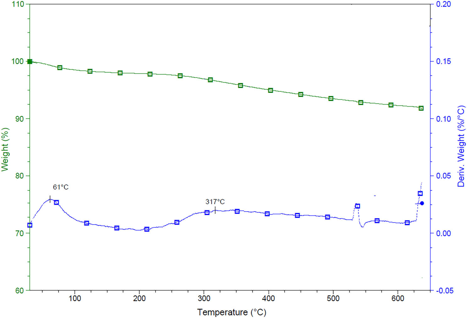
Thermogram (TGA) for investigated soil samples (weight in %) – upper curve, (deriv. weight in %) – lower curve.
As can be interpreted from Figure 3, the glomalin extraction procedure and the calibration with BSA introduce some unsolved questions. The selectivity and specificity of the Bradford test, as well as the quantification parameters, have been the subject of critical examination in recent years [21]. Thus, our results should be interpreted carefully. In addition to all the significant influences and processes, the structure of glomalin itself, that is, the GRSP protein of the soil extract, has not been explicitly defined. The relationship between protein and humic compounds, as well as the additional definition of the basic Bradford test, is the subject of recent research [21]. The content of different GRSP fractions extracted at different pH [22] is assumed to have been underestimated, due to the co-extraction of humic acids. Interferences with different soil types, overestimations by the method of standard addition, and correction of absorbance parameters are required for a reasonable quantification of GRSP [23]. It was also found that the EE-GRSP concentration values determined by the Bradford assay were dependent and variable with the dilution level of the soil extract; moreover, the Bradford assay is unstable over time [24]. Suggestions were also made that for improved accuracy of GRSP estimates using the Bradford method, extracts should be diluted, and the pH-specific absorbance of colored extracts should be subtracted [25].
Based on the TGA analysis, it can be observed that at a temperature of about 317°C, there is an increase in the speed and intensity of the combustion of organic matter. The discrepancy between the results of the WB method and the dry burning method was determined due to the partial oxidation of organic matter by dichromate ions. With increasing SOM content, this error increases, and for certain soils, a conversion factor of 1.3 from the WB method to dissolved organic carbon has been recommended [26]. If we compare the values of organic matter percentage of dry and wet burning, we generally estimate that, for both samples, ≈60% of organic matter is easily oxidizable.
Together, these data suggest that, based on the comparison of dry and wet burning methods, both samples contain relatively young labile organic matter with a low degree of humification.
3.2 Spectroscopic characterization of soil and soil extracts
3.2.1 FTIR spectroscopic measurements
In order to better understand the glomalin extract and to also examine the protein structures and agglomeration of the soil particles, soil and the extract were analyzed using spectroscopic methods. The structural characterization of the particles themselves is necessary in terms of defining glomalin as a potential indicator, considering that it is already defined as glue in the soil [27] that is largely responsible for the aggregation of particles. Figure 5 shows the transmission FTIR spectra of both the soil sample and its glomalin extracts. Table 3 shows the assignments of the observed bands in the soil and the extracts.

FTIR spectra of the soil and soil glomalin extracts.
Assignments of the bands observed in the soil and the soil extract
| Specific range//potential assignment | Observed bands (cm−1) + Band description | ||
|---|---|---|---|
| Soil | Soil glomalin extract | ||
| 1 | Range (3,750–3,250)//(O–H, N–H stretching) | 3697.2 | 3432.1 |
| 3620.7 | |||
| 3427.8 | |||
| 2 | Range (3,000–2,800)//Aliphatic C–H stretching | 2927.4 | — |
| 3 | Range (1,700–1,500)//water deformation, amide I and II stretching, aliphatic deformations | 1634.4 | 1587.8 very strong |
| 4 | Range (1,500–1,300)//Aromatic C═C lignine, amide II, aliphatic deformation polysaccharides | — | 1396.1 very strong |
| 5 | Range (1,300–900)//Aluminosilicate lattice vibrations | 1031.1 very strong | 1274.9 |
| 1078.4 | |||
| 6 | Range (900–700)//Kaolin minerals + aromatic deformations | 779.3 | 915.5 |
| 776.3 | |||
| 693.8 | 841.9 | ||
| 647.1 | |||
Based on the data presented in Figure 4 and Table 3, we conclude that the FTIR spectra of soil, as compared to the spectra of the extracts, differ the most in two ranges: (1) the range of vibrations of aluminosilicate groups (1,200–1,000 cm−1) and (2) the range of vibrations of amide-protein groups 1,600–1,300 cm−1 (amide I and II bands). As is clear from the overlapped spectra, the spectra of the pure soil show a very strong band at 1,031 cm−1, which originates from vibrations of layered aluminosilicate groups. This difference in the spectra indicates that the extraction process with citrate buffer separates the organic from the inorganic fractions and yields overlapping bands in the spectra. As for the vibrations of the amide groups, a clear difference exists in the intensity of the amide bands I and II in the spectra of the extract samples; very strong bands appear at around 1,580 and 1,398 cm−1.
Two significant differences in the FTIR spectra before and after the extraction of glomalin can serve as a preliminary indicator of the relationship between sand fractions and fractions of organic matter of the glomalin type. The latter impacts particle aggregation and, thus, erosion potential. This approach aligns with the findings of Jović et al. [28], who illustrated that the particle size of soils significantly influences erosion potential and various mechanical properties. Because the FTIR spectra contain considerable numbers of overlaps, and because the extraction process is not selective, further research with a much larger number of samples is needed. Such work might show more variability, which could be standardized to the extent possible and used as a rapid spectroscopic indicator, perhaps with greater confidence than the results obtained by classical quantitative determinations of organic matter and glomalin.
3.2.2 DLS measurements
In order to better define the characteristics of the glomalin extract, a DLS analysis of the distribution of particles and their zeta potential was performed (Figure 6).

DLS spectra of investigated soil extract samples (three measurements of same the sample).
The soil sample has a very wide particle size distribution (80–1,000 nm) with mean particle size values at ca. 300 nm (Figure 6). Additionally, a small group of particles with a size of about 6 µm can be observed. The distributions, as well as the value of their semidispersity index, indicate a wide variety of particle sizes, which can be expected in a sample such as a soil extract with an assumed protein content. Data on the zeta potential of the sample particles yielded negative mean zeta potential values of −22.3, −20.7, and −21.7 mV. The relatively low negative zeta potential values indicate a potential for stability of the particles in terms of aggregation. Nonetheless, zeta potential values are only one of the factors that influence soil aggregate stability.
These results could be in accordance with the nature of the proteins found in the soil extract, which are polymers of diverse amino acid composition, and thus of variously charged parts of the macromolecules.
3.2.3 Scanning electronic microscopy measurements
The morphologies of the soil, the evaporated extract of glomalin, and the soil sample after glomalin extraction are shown in Figure 7. The soil sample has relatively sharp-edged structures and particles with diameters of ≈2 to several tens (30–40) of micrometers. A comparison of images of the soil and its evaporated glomalin extract shows the smooth structures and less independence of individual particles of the glomalin extract. After extraction of glomalin from the samples, the distribution of particles is quite different and shifted towards lower values.

SEM images of the soil sample (left), evaporated glomalin extract (middle), and soil after glomalin extraction (right).
A comparison of the SEM images with the DLS results presents some interesting results; i.e., according to DLS, the glomalin extract contains two groups of particle distribution, one of 0.08–1 µm and a smaller group of larger particles of 6 µm. In the SEM image of the glomalin extract (Figure 7), a series of interconnected, smooth structures, with a wider distribution of particles, is evident. Thus, we assume that by extracting glomalin from the soil, only a smaller fraction of the protein gets isolated, i.e., a conglomerate of proteins and smaller particles – those particles that were less tightly bound by glomalin. We suggest that soil aggregation depends not only on the mineralogy but also on the specificity and character of the organic matter (and its stability). It would be interesting to determine whether this process is affected by changes in soil moisture, as is the case with clay particles and carbonates, which correspond to alternating wet and dry periods that increase soil aggregation [29,30,31]. Polysaccharides of cyanobacteria also work in a similar way, which in wet phases create a sticky polysaccharide network, and during dry phases, cyanobacteria and other soil microorganisms create solid surface coverings that prevent erosion [32,33].
4 Possible practical implications in erosion mitigation and further development
Contemporary studies point out that glomalin has numerous applications related to agricultural practices, land restoration, and climate-resilient soil management, with promising potential in erosion control and mitigation. As highlighted by Singh et al. [6], glomalin serves various functions in the context of soil degradation (Figure 8). Soil degradation in Europe is being accelerated by soil erosion due to conventional agricultural practices [1]. Stockmann et al. [34] emphasized that most soil properties are influenced by the quantity and quality of SOM. The work of Obalum et al. [35] discussed that SOM can be considered a singular indication of soil degradation, even if not a universally applicable indicator.
![Figure 8
The various roles of glomalin in the context of soil degradation, with a particular focus on mitigating soil erosion (modified after [6]).](/document/doi/10.1515/geo-2022-0731/asset/graphic/j_geo-2022-0731_fig_008.jpg)
The various roles of glomalin in the context of soil degradation, with a particular focus on mitigating soil erosion (modified after [6]).
We argue that glomalin functions as a catalyst for wider ecological restoration practice that might follow mining, salinization, deforestation, overgrazing, and wind- and water-based erosion [6]. Glomalin’s natural hydrophobic nature also positions it as a binding agent during aggregate formation, enhancing its potential in erosion studies.
Svirčev et al. [32,33] pointed out that, in semi-arid and arid regions, biocrusts serve to stabilize surfaces, providing protection against wind and water erosion. However, these crusts are also highly susceptible to both anthropogenic and natural disturbances. Wind and water erosion of (disturbed) biocrusts are believed to trigger a chain reaction, as the exposed and windblown silt from the substrate possesses a more abrasive force than wind alone. Thus, disruption of a biocrust may trigger disturbances across a larger area. At regional and long-term scales, land use in regions with porous sediments (e.g., loess) and the subsequent erosion contribute to colluviation, with climatic fluctuations being of only secondary importance. Alternatively soil aggregate formation as influenced by glomalin, released by AMF external hyphae and spore walls, facilitates the binding of soil particles to other organic matter, such as partially decomposed particulate organic matter [6,36,37]. This characteristic has been observed in various soil types and climatic conditions, enhancing its potential to limit soil erosion.
It is important to emphasize that glomalin contributes to binding within microaggregates and macroaggregates along with mineral and other organic particles [38]. A limited number of studies have delved into the role of glomalin in relation to soil hydraulic properties. Moebius‐Clune et al. [39] found that an increased concentration of glomalin led to improvements in various hydraulic properties, including water penetration, saturated hydraulic conductivity, infiltrability, porosity, and soil water potential. Further exploration in this direction is necessary to address this research gap. Future research should investigate whether this process is influenced by changes in soil moisture, similar to the case of clay particles and carbonates, which respond to alternating wet and dry periods that enhance soil aggregation [29,30,31]. Similarly, cyanobacterial polysaccharides behave in a comparable manner, forming a rather sticky polysaccharide surface during wet phases to which mineral grains, mostly airborne, adhere. During dry phases, cyanobacteria and other soil microorganisms form robust surface crusts that inhibit erosion [32,33]. Glomalin may also act as a catalyst for soil recultivation for wind and water-based erosion, broadening its applicability in erosion studies across various biogeographic zones [40].
Bearing in mind all these aspects, one of the remarkable features of glomalin is its suitability for sustainable, climate-resilient soil management. As noted by Wolf et al. [41], soil microorganisms, play a vital role by acting as “water and nutrient miners” for plants, thereby enhancing their drought tolerance and contributing to the climate resilience and yield stability of cropping systems. Furthermore, the more recent study by Yang et al. [42] discusses the critical role of soil aggregation and aggregate-associated carbon (C) in promoting soil health and carbon sequestration. The authors argue that AMF are recognized as primary soil aggregators, owing to the synergistic effects of their extraradical hyphae and GRSPs. Notably, the diversity of the AMF community in fallow land was found to be greater than in cropland and increased with rising mean annual temperature and mean annual precipitation. According to the authors, fallow land also enhanced the network complexity of the AMF community. The given work underscores the significant potential of AMF in carbon sequestration and climate change mitigation, particularly in the context of combating soil erosion, which can undermine soil health and reduce carbon storage capacity [43].
Future studies may wish to concentrate on local erosion processes with varying intensities of erosion and deposition, significantly influencing the diverse properties of soil. These studies should utilize empirical models to investigate this interaction, enabling the assessment of erosion rates in a changing climate and fostering a more comprehensive understanding of glomalin’s potential applications.
5 Concluding remarks
Soil erosion, marked by the progressive loss of fertile topsoil and its detrimental effects on agricultural productivity, has emerged as a critical global environmental issue, with similar patterns observed in Southeast Europe, including Serbia. Among the least studied components of SOM is glomalin, or glomalin-type proteins, which play a vital role in stabilizing structural aggregates and accumulate in high concentrations, representing a significant fraction of SOM. Given that only a limited number of studies have explored the responsiveness of glomalin to changes in the soil environment due to degradation, this study uniquely extracted and geochemically characterized glomalin proteins from Serbian soil using standard chemical and spectroscopic methods.
The findings from DLS and SEM analyses reveal that the glomalin extract consists of two particle size groups (0.08–1 and 6 µm), suggesting that the extraction process isolates a smaller fraction of proteins and less tightly bound particles, indicating that soil aggregation is influenced by both mineralogy and the characteristics of organic matter. Additionally, FTIR spectra demonstrate two significant differences before and after glomalin extraction, highlighting the relationship between sand fractions and organic matter that affects particle aggregation and erosion potential. These insights are crucial for understanding the role of glomalin in mitigating soil degradation, particularly soil erosion.
Moreover, the results of this study can inform the creation and implementation of mitigation practices aimed at the sustainable restoration of degraded soils at both local and regional levels. Future research should focus on characterizing glomalin proteins in a larger number of heterogeneous soil samples from a broader area. Undisturbed soil samples should be collected from depths of 0–30 cm, 30–60 cm, and 60–90 cm across each land use category, with three replicates taken approximately 10 m apart. This approach will facilitate a more comprehensive understanding of glomalin’s applications in erosion control and land restoration, yielding reliable and thorough results that can inform effective soil erosion mitigation measures. The broader applications of glomalin in erosion and the reclamation of degraded soils must be evaluated by assessing the long-term impacts of current land use practices under changing climate conditions, with the goal of developing strategies that mitigate soil erosion and enhance environmental sustainability.
Acknowledgments
The authors acknowledge the support of the Ministry of Science, Technological Development and Innovation of the Republic of Serbia (Grant Nos 451-03-66/2024-03/200125 & 451-03-65/2024-03/200125). Furthermore, B.J., T.L., and S.B.M. express their gratitude to the Provincial Secretariat for Higher Education and Scientific Research of Vojvodina (Serbia), No. 000871816 2024 09418 003 000 000 001 04 002 (GLOMERO), under Program 0201 and Program Activity 1012. Part of the research was supported by the Program of Cooperation with the Serbian Scientific Diaspora – Joint Research Projects – DIASPORA 2023, from the Science Fund of the Republic of Serbia, under the project LAMINATION (The Loess Plateau Margins: Towards Innovative Sustainable Conservation), Project number: 17807. The authors acknowledge the unconditional help of Petar Krsmanović regarding the study area map. Finally, the authors are grateful to the anonymous reviewers whose comments and suggestions improved the manuscript.
-
Funding information: The authors acknowledge the support of the Ministry of Science, Technological Development and Innovation of the Republic of Serbia (Grant Nos 451-03-66/2024-03/200125 & 451-03-65/2024-03/200125). Furthermore, B.J., T.L., and S.B.M. express their gratitude to the Provincial Secretariat for Higher Education and Scientific Research of Vojvodina (Serbia), No. 000871816 2024 09418 003 000 000 001 04 002 (GLOMERO), under Program 0201 and Program Activity 1012. Part of the research was supported by the Program of Cooperation with the Serbian Scientific Diaspora – Joint Research Projects – DIASPORA 2023, from the Science Fund of the Republic of Serbia, under the project LAMINATION (The Loess Plateau Margins: Towards Innovative Sustainable Conservation), Project number: 17807.
-
Author contributions: B.J., D.J., and N.R. designed the experiments and B.J. carried them out. T.L., R.J.S., and S.B.M. helped with the interpretation of the results. B.J., T.L., R.J.S., and S.B.M. prepared the manuscript with contributions from all co-authors. Technical editing and revision were performed by B.J., and T.L. Supervision was conducted by R.J.S. and S.B.M.
-
Conflict of interest: The authors state no conflict of interest.
-
Ethical approval: The conducted research is not related to either human or animal use.
-
Data availability statement: The datasets generated during and/or analyzed during the current study are available from the corresponding author on reasonable request.
References
[1] Poesen J. Soil erosion in the Anthropocene: Research needs. Earth Surf Process Landf. 2017;43(1):64–84. 10.1002/esp.4250.Search in Google Scholar
[2] Micić Ponjiger T, Lukić T, Basarin B, Jokić M, Wilby RL, Pavić D, et al. Detailed analysis of Spatial–Temporal variability of rainfall erosivity and erosivity density in the Central and Southern Pannonian basin. Sustainability. 2021;13(23):13355. 10.3390/su132313355.Search in Google Scholar
[3] Micić Ponjiger T, Lukić T, Wilby RL, Marković SB, Valjarević A, Dragićević S, et al. Evaluation of rainfall erosivity in the Western Balkans by mapping and clustering ERA5 reanalysis data. Atmosphere. 2023;14(1):104. 10.3390/atmos14010104.Search in Google Scholar
[4] Lukić T, Lukić A, Basarin B, Micić Ponjiger T, Blagojević D, Mesaroš M, et al. Rainfall erosivity and extreme precipitation in the Pannonian basin. Open Geosci. 2019;11(1):664–81. 10.1515/geo-2019-0053.Search in Google Scholar
[5] Vaidya GS, Rillig MC, Wallander H. The role of glomalin in soil erosion. Sci World. 2011;9(9):82–5. 10.3126/sw.v9i9.5524.Search in Google Scholar
[6] Singh AK, Zhu X, Chen C, Jian W, Yang B, Zakari S, et al. The role of glomalin in mitigation of multiple soil degradation problems. Crit Rev Environ Sci Technol. 2020;52(9):1604–38. 10.1080/10643389.2020.1862561.Search in Google Scholar
[7] Šarapatka B, Alvarado-Solano DP, Čižmár D. Can glomalin content be used as an indicator for erosion damage to soil and related changes in organic matter characteristics and nutrients? Catena. 2019;181:104078. 10.1016/j.catena.2019.104078.Search in Google Scholar
[8] Kumar S, Singh AK, Ghosh P. Distribution of soil organic carbon and glomalin related soil protein in reclaimed coal mine-land chronosequence under tropical condition. Sci Total Environ. 2018;625:1341–50. 10.1016/j.scitotenv.2018.01.061.Search in Google Scholar PubMed
[9] Vlček V, Pohanka M. Glomalin – an interesting protein part of the soil organic matter. Soil Water Res. 2020;15(2):67–74. 10.17221/29/2019-swr.Search in Google Scholar
[10] Lin H, Duan X, Li Y, Zhang L, Li R, Li R. Simulating the effects of erosion on organic carbon dynamics in agricultural soils. CATENA. 2022;208:105753. 10.1016/j.catena.2021.105753.Search in Google Scholar
[11] Khursheed S. “Glomalin” a key to locking up soil carbon. Adv Plants Agric Res. 2016;4(1):00126. 10.15406/apar.2016.04.00126.Search in Google Scholar
[12] Gao Y, Zhou Z, Ling W, Hu X, Chen S. Glomalin-related soil protein enhances the availability of polycyclic aromatic hydrocarbons in soil. Soil Biol Biochem. 2017;107:129–32. 10.1016/j.soilbio.2017.01.002.Search in Google Scholar
[13] Chen S, Zhou Z, Tsang DCW, Wang J, Odinga ES, Gao Y. Glomalin-related soil protein reduces the sorption of polycyclic aromatic hydrocarbons by soils. Chemosphere. 2020;260:127603. 10.1016/j.chemosphere.2020.127603.Search in Google Scholar PubMed
[14] Gujre N, Agnihotri R, Rangan L, Sharma MP, Mitra S. Deciphering the dynamics of glomalin and heavy metals in soils contaminated with hazardous municipal solid wastes. J Hazard Mater. 2021;416:125869. 10.1016/j.jhazmat.2021.125869.Search in Google Scholar PubMed
[15] Zhang J, Tang X, He X, Liu J. Glomalin-related soil protein responses to elevated CO2 and nitrogen addition in a subtropical forest: Potential consequences for soil carbon accumulation. Soil Biol Biochem. 2015;83:142–9. 10.1016/j.soilbio.2015.01.023.Search in Google Scholar
[16] Mihailović A, Budinski-Petković L, Popov S, Ninkov J, Vasin J, Ralević NM, et al. Spatial distribution of metals in urban soil of Novi Sad, Serbia: GIS based approach. J Geochem Explor. 2015;150:104–14. 10.1016/j.gexplo.2014.12.017.Search in Google Scholar
[17] Malinović‐Milićević S, Mihailović DT, Radovanović M, Drešković N. Extreme precipitation indices in Vojvodina region (Serbia). Zbornik Radova: Geografski Inst Jovan Cvijić. 2018;68(1):1–15. 10.2298/ijgi1801001m.Search in Google Scholar
[18] Lukić T, Micić Ponjiger T, Basarin B, Sakulski D, Gavrilov MB, Marković SB, et al. Application of Angot precipitation index in the assessment of rainfall erosivity: Vojvodina Region case study (North Serbia). Acta Geogr Slov. 2021;61(2):123–53. 10.3986/ags.8754.Search in Google Scholar
[19] ISSS – International Society of Soil Science. World reference base for soil resources; FAO, Rome, 2006.Search in Google Scholar
[20] Mihailović A. Fizičke karakteristike zemljišta i distribucija teških metala na gradskom području Novog Sada. Doktorska disertacija u rukopisu, Univerzitet u Novom Sadu, Novi Sad, Srbija; 2015 (in Serbian).Search in Google Scholar
[21] Redmile‐Gordon M, Armenise E, White RP, Hirsch PR, Goulding K. A comparison of two colorimetric assays, based upon Lowry and Bradford techniques, to estimate total protein in soil extracts. Soil Biol Biochem. 2013;67:166–73. 10.1016/j.soilbio.2013.08.017.Search in Google Scholar PubMed PubMed Central
[22] Jorge-Araujo P, Quiquampoix H, Matumoto‐Pintro PT, Staunton S. Glomalin‐related soil protein in French temperate forest soils: interference in the Bradford assay caused by co‐extracted humic substances. Eur J Soil Sci. 2014;66(2):311–9. 10.1111/ejss.12218.Search in Google Scholar
[23] Moragues-Saitua L, Merino‐Martín L, Stokes A, Staunton S. Towards meaningful quantification of glomalin‐related soil protein (GRSP) taking account of interference in the Coomassie Blue (Bradford) assay. Eur J Soil Sci. 2018;70(4):727–35. 10.1111/ejss.12698.Search in Google Scholar
[24] Reyna DL, Wall LG. Revision of two colorimetric methods to quantify glomalin-related compounds in soils subjected to different managements. Biol Fertil Soils. 2013;50(2):395–400. 10.1007/s00374-013-0834-2.Search in Google Scholar
[25] Cissé G, Essi M, Nicolas M, Staunton S. Bradford quantification of Glomalin-Related Soil Protein in coloured extracts of forest soils. Geoderma. 2020;372:114394. 10.1016/j.geoderma.2020.114394.Search in Google Scholar
[26] Richardson JL, Bigler RJ. Comparison of walkley‐black and dry combustion organic carbon determinations in calcareous water‐logged north Dakota soils. Commun Soil Sci Plant Anal. 1982;13(3):175–83. 10.1080/00103628209367256.Search in Google Scholar
[27] Rillig MC, Mummey DL. Mycorrhizas and soil structure. N Phytologist. 2006;171(1):41–53. 10.1111/j.1469-8137.2006.01750.x.Search in Google Scholar PubMed
[28] Jović B, Ćirić V, Kovačević M, Šeremešić S, Kordić B. Empirical equation for preliminary assessment of soil texture. Spectrochim Acta Part A: Mol Biomol Spectrosc. 2019;206:506–11. 10.1016/j.saa.2018.08.039.Search in Google Scholar PubMed
[29] Smalley I, Marković SB. Loessification and hydroconsolidation: There is a connection. CATENA. 2014;117:94–9. 10.1016/j.catena.2013.07.006.Search in Google Scholar
[30] Smalley I, Ngambi S. Problems with collapsible soils: Particle types and inter-particle bonding. Open Geosci. 2019;11(1):829–36. 10.1515/geo-2019-0064.Search in Google Scholar
[31] Lukić T, Bjelajac D, Fitzsimmons KE, Marković SB, Basarin B, Mlađan D, et al. Factors triggering landslide occurrence on the Zemun loess plateau, Belgrade area, Serbia. Environ Earth Sci. 2018;77(13):519. 10.1007/s12665-018-7712-z.Search in Google Scholar
[32] Svirčev Z, Marković SB, Stevens T, Codd GA, Smalley I, Simeunović J, et al. Importance of biological loess crusts for loess formation in semi-arid environments. Quat Int. 2013;296:206–15. 10.1016/j.quaint.2012.10.048.Search in Google Scholar
[33] Svirčev Z, Dulić T, Obreht I, Codd GA, Lehmkuhl F, Marković SB, et al. Cyanobacteria and loess – an underestimated interaction. Plant Soil. 2019;439(1–2):293–308. 10.1007/s11104-019-04048-3.Search in Google Scholar
[34] Stockmann U, Adams MA, Crawford JW, Field DJ, Henakaarchchi N, Jenkins ME, et al. The knowns, known unknowns and unknowns of sequestration of soil organic carbon. Agric Ecosyst Environ. 2013;164:80–99. 10.1016/j.agee.2012.10.001.Search in Google Scholar
[35] Obalum SE, Chibuike G, Peth S, Ouyang Y. Soil organic matter as sole indicator of soil degradation. Environ Monit Assess. 2017;189(4):176. 10.1007/s10661-017-5881-y.Search in Google Scholar PubMed
[36] Liu H, Wang X, Liang C, Ai Z, Wu Y, Xu H, et al. Glomalin-related soil protein affects soil aggregation and recovery of soil nutrient following natural revegetation on the Loess Plateau. Geoderma. 2020;357:113921. 10.1016/j.geoderma.2019.113921.Search in Google Scholar
[37] Luna L, Miralles I, Andrenelli MC, Gispert M, Pellegrini S, Vignozzi N, et al. Restoration techniques affect soil organic carbon, glomalin and aggregate stability in degraded soils of a semiarid Mediterranean region. Catena. 2016;143:256–64. 10.1016/j.catena.2016.04.013.Search in Google Scholar
[38] Wright S, Green VS, Cavigelli MA. Glomalin in aggregate size classes from three different farming systems. Soil Tillage Res. 2007;94(2):546–9. 10.1016/j.still.2006.08.003.Search in Google Scholar
[39] Moebius‐Clune BN, Van Es HM, Idowu OJ, Schindelbeck RR, Moebius-Clune DJ, Wolfe DW, et al. Long‐term effects of harvesting maize stover and tillage on soil quality. Soil Sci Soc Am J. 2008;72(4):960–9. 10.2136/sssaj2007.0248.Search in Google Scholar
[40] Holátko J, Brtnický M, Kučerík J, Kotianová M, Elbl J, Kintl A, et al. Glomalin – Truths, myths, and the future of this elusive soil glycoprotein. Soil Biol Biochem. 2021;153:108116. 10.1016/j.soilbio.2020.108116.Search in Google Scholar
[41] Wolf MK, Wiesmeier M, Macholdt J. Importance of soil fertility for climate-resilient cropping systems: The farmer’s perspective. Soil Secur. 2023;13:100119. 10.1016/j.soisec.2023.100119.Search in Google Scholar
[42] Yang Y, Luo W, Xu J, Guan P, Chang L, Wu X, et al. Fallow land enhances carbon sequestration in glomalin and soil aggregates through regulating diversity and network complexity of arbuscular mycorrhizal fungi under climate change in relatively high-latitude regions. Front Microbiol. 2022;13:930622. 10.3389/fmicb.2022.930622.Search in Google Scholar PubMed PubMed Central
[43] Spalevic V, Barati AA, Goli I, Moghaddam SM, Azadi H. Do changes in land use and climate change overlap? An analysis of the World Bank Data. Land Degrad Dev. 2024;35(16):4814–29. 10.1002/ldr.5259.Search in Google Scholar
© 2024 the author(s), published by De Gruyter
This work is licensed under the Creative Commons Attribution 4.0 International License.
Articles in the same Issue
- Regular Articles
- Theoretical magnetotelluric response of stratiform earth consisting of alternative homogeneous and transitional layers
- The research of common drought indexes for the application to the drought monitoring in the region of Jin Sha river
- Evolutionary game analysis of government, businesses, and consumers in high-standard farmland low-carbon construction
- On the use of low-frequency passive seismic as a direct hydrocarbon indicator: A case study at Banyubang oil field, Indonesia
- Water transportation planning in connection with extreme weather conditions; case study – Port of Novi Sad, Serbia
- Zircon U–Pb ages of the Paleozoic volcaniclastic strata in the Junggar Basin, NW China
- Monitoring of mangrove forests vegetation based on optical versus microwave data: A case study western coast of Saudi Arabia
- Microfacies analysis of marine shale: A case study of the shales of the Wufeng–Longmaxi formation in the western Chongqing, Sichuan Basin, China
- Multisource remote sensing image fusion processing in plateau seismic region feature information extraction and application analysis – An example of the Menyuan Ms6.9 earthquake on January 8, 2022
- Identification of magnetic mineralogy and paleo-flow direction of the Miocene-quaternary volcanic products in the north of Lake Van, Eastern Turkey
- Impact of fully rotating steel casing bored pile on adjacent tunnels
- Adolescents’ consumption intentions toward leisure tourism in high-risk leisure environments in riverine areas
- Petrogenesis of Jurassic granitic rocks in South China Block: Implications for events related to subduction of Paleo-Pacific plate
- Differences in urban daytime and night block vitality based on mobile phone signaling data: A case study of Kunming’s urban district
- Random forest and artificial neural network-based tsunami forests classification using data fusion of Sentinel-2 and Airbus Vision-1 satellites: A case study of Garhi Chandan, Pakistan
- Integrated geophysical approach for detection and size-geometry characterization of a multiscale karst system in carbonate units, semiarid Brazil
- Spatial and temporal changes in ecosystem services value and analysis of driving factors in the Yangtze River Delta Region
- Deep fault sliding rates for Ka-Ping block of Xinjiang based on repeating earthquakes
- Improved deep learning segmentation of outdoor point clouds with different sampling strategies and using intensities
- Platform margin belt structure and sedimentation characteristics of Changxing Formation reefs on both sides of the Kaijiang-Liangping trough, eastern Sichuan Basin, China
- Enhancing attapulgite and cement-modified loess for effective landfill lining: A study on seepage prevention and Cu/Pb ion adsorption
- Flood risk assessment, a case study in an arid environment of Southeast Morocco
- Lower limits of physical properties and classification evaluation criteria of the tight reservoir in the Ahe Formation in the Dibei Area of the Kuqa depression
- Evaluation of Viaducts’ contribution to road network accessibility in the Yunnan–Guizhou area based on the node deletion method
- Permian tectonic switch of the southern Central Asian Orogenic Belt: Constraints from magmatism in the southern Alxa region, NW China
- Element geochemical differences in lower Cambrian black shales with hydrothermal sedimentation in the Yangtze block, South China
- Three-dimensional finite-memory quasi-Newton inversion of the magnetotelluric based on unstructured grids
- Obliquity-paced summer monsoon from the Shilou red clay section on the eastern Chinese Loess Plateau
- Classification and logging identification of reservoir space near the upper Ordovician pinch-out line in Tahe Oilfield
- Ultra-deep channel sand body target recognition method based on improved deep learning under UAV cluster
- New formula to determine flyrock distance on sedimentary rocks with low strength
- Assessing the ecological security of tourism in Northeast China
- Effective reservoir identification and sweet spot prediction in Chang 8 Member tight oil reservoirs in Huanjiang area, Ordos Basin
- Detecting heterogeneity of spatial accessibility to sports facilities for adolescents at fine scale: A case study in Changsha, China
- Effects of freeze–thaw cycles on soil nutrients by soft rock and sand remodeling
- Vibration prediction with a method based on the absorption property of blast-induced seismic waves: A case study
- A new look at the geodynamic development of the Ediacaran–early Cambrian forearc basalts of the Tannuola-Khamsara Island Arc (Central Asia, Russia): Conclusions from geological, geochemical, and Nd-isotope data
- Spatio-temporal analysis of the driving factors of urban land use expansion in China: A study of the Yangtze River Delta region
- Selection of Euler deconvolution solutions using the enhanced horizontal gradient and stable vertical differentiation
- Phase change of the Ordovician hydrocarbon in the Tarim Basin: A case study from the Halahatang–Shunbei area
- Using interpretative structure model and analytical network process for optimum site selection of airport locations in Delta Egypt
- Geochemistry of magnetite from Fe-skarn deposits along the central Loei Fold Belt, Thailand
- Functional typology of settlements in the Srem region, Serbia
- Hunger Games Search for the elucidation of gravity anomalies with application to geothermal energy investigations and volcanic activity studies
- Addressing incomplete tile phenomena in image tiling: Introducing the grid six-intersection model
- Evaluation and control model for resilience of water resource building system based on fuzzy comprehensive evaluation method and its application
- MIF and AHP methods for delineation of groundwater potential zones using remote sensing and GIS techniques in Tirunelveli, Tenkasi District, India
- New database for the estimation of dynamic coefficient of friction of snow
- Measuring urban growth dynamics: A study in Hue city, Vietnam
- Comparative models of support-vector machine, multilayer perceptron, and decision tree predication approaches for landslide susceptibility analysis
- Experimental study on the influence of clay content on the shear strength of silty soil and mechanism analysis
- Geosite assessment as a contribution to the sustainable development of Babušnica, Serbia
- Using fuzzy analytical hierarchy process for road transportation services management based on remote sensing and GIS technology
- Accumulation mechanism of multi-type unconventional oil and gas reservoirs in Northern China: Taking Hari Sag of the Yin’e Basin as an example
- TOC prediction of source rocks based on the convolutional neural network and logging curves – A case study of Pinghu Formation in Xihu Sag
- A method for fast detection of wind farms from remote sensing images using deep learning and geospatial analysis
- Spatial distribution and driving factors of karst rocky desertification in Southwest China based on GIS and geodetector
- Physicochemical and mineralogical composition studies of clays from Share and Tshonga areas, Northern Bida Basin, Nigeria: Implications for Geophagia
- Geochemical sedimentary records of eutrophication and environmental change in Chaohu Lake, East China
- Research progress of freeze–thaw rock using bibliometric analysis
- Mixed irrigation affects the composition and diversity of the soil bacterial community
- Examining the swelling potential of cohesive soils with high plasticity according to their index properties using GIS
- Geological genesis and identification of high-porosity and low-permeability sandstones in the Cretaceous Bashkirchik Formation, northern Tarim Basin
- Usability of PPGIS tools exemplified by geodiscussion – a tool for public participation in shaping public space
- Efficient development technology of Upper Paleozoic Lower Shihezi tight sandstone gas reservoir in northeastern Ordos Basin
- Assessment of soil resources of agricultural landscapes in Turkestan region of the Republic of Kazakhstan based on agrochemical indexes
- Evaluating the impact of DEM interpolation algorithms on relief index for soil resource management
- Petrogenetic relationship between plutonic and subvolcanic rocks in the Jurassic Shuikoushan complex, South China
- A novel workflow for shale lithology identification – A case study in the Gulong Depression, Songliao Basin, China
- Characteristics and main controlling factors of dolomite reservoirs in Fei-3 Member of Feixianguan Formation of Lower Triassic, Puguang area
- Impact of high-speed railway network on county-level accessibility and economic linkage in Jiangxi Province, China: A spatio-temporal data analysis
- Estimation model of wild fractional vegetation cover based on RGB vegetation index and its application
- Lithofacies, petrography, and geochemistry of the Lamphun oceanic plate stratigraphy: As a record of the subduction history of Paleo-Tethys in Chiang Mai-Chiang Rai Suture Zone of Thailand
- Structural features and tectonic activity of the Weihe Fault, central China
- Application of the wavelet transform and Hilbert–Huang transform in stratigraphic sequence division of Jurassic Shaximiao Formation in Southwest Sichuan Basin
- Structural detachment influences the shale gas preservation in the Wufeng-Longmaxi Formation, Northern Guizhou Province
- Distribution law of Chang 7 Member tight oil in the western Ordos Basin based on geological, logging and numerical simulation techniques
- Evaluation of alteration in the geothermal province west of Cappadocia, Türkiye: Mineralogical, petrographical, geochemical, and remote sensing data
- Numerical modeling of site response at large strains with simplified nonlinear models: Application to Lotung seismic array
- Quantitative characterization of granite failure intensity under dynamic disturbance from energy standpoint
- Characteristics of debris flow dynamics and prediction of the hazardous area in Bangou Village, Yanqing District, Beijing, China
- Rockfall mapping and susceptibility evaluation based on UAV high-resolution imagery and support vector machine method
- Statistical comparison analysis of different real-time kinematic methods for the development of photogrammetric products: CORS-RTK, CORS-RTK + PPK, RTK-DRTK2, and RTK + DRTK2 + GCP
- Hydrogeological mapping of fracture networks using earth observation data to improve rainfall–runoff modeling in arid mountains, Saudi Arabia
- Petrography and geochemistry of pegmatite and leucogranite of Ntega-Marangara area, Burundi, in relation to rare metal mineralisation
- Prediction of formation fracture pressure based on reinforcement learning and XGBoost
- Hazard zonation for potential earthquake-induced landslide in the eastern East Kunlun fault zone
- Monitoring water infiltration in multiple layers of sandstone coal mining model with cracks using ERT
- Study of the patterns of ice lake variation and the factors influencing these changes in the western Nyingchi area
- Productive conservation at the landslide prone area under the threat of rapid land cover changes
- Sedimentary processes and patterns in deposits corresponding to freshwater lake-facies of hyperpycnal flow – An experimental study based on flume depositional simulations
- Study on time-dependent injectability evaluation of mudstone considering the self-healing effect
- Detection of objects with diverse geometric shapes in GPR images using deep-learning methods
- Behavior of trace metals in sedimentary cores from marine and lacustrine environments in Algeria
- Spatiotemporal variation pattern and spatial coupling relationship between NDVI and LST in Mu Us Sandy Land
- Formation mechanism and oil-bearing properties of gravity flow sand body of Chang 63 sub-member of Yanchang Formation in Huaqing area, Ordos Basin
- Diagenesis of marine-continental transitional shale from the Upper Permian Longtan Formation in southern Sichuan Basin, China
- Vertical high-velocity structures and seismic activity in western Shandong Rise, China: Case study inspired by double-difference seismic tomography
- Spatial coupling relationship between metamorphic core complex and gold deposits: Constraints from geophysical electromagnetics
- Disparities in the geospatial allocation of public facilities from the perspective of living circles
- Research on spatial correlation structure of war heritage based on field theory. A case study of Jinzhai County, China
- Formation mechanisms of Qiaoba-Zhongdu Danxia landforms in southwestern Sichuan Province, China
- Magnetic data interpretation: Implication for structure and hydrocarbon potentiality at Delta Wadi Diit, Southeastern Egypt
- Deeply buried clastic rock diagenesis evolution mechanism of Dongdaohaizi sag in the center of Junggar fault basin, Northwest China
- Application of LS-RAPID to simulate the motion of two contrasting landslides triggered by earthquakes
- The new insight of tectonic setting in Sunda–Banda transition zone using tomography seismic. Case study: 7.1 M deep earthquake 29 August 2023
- The critical role of c and φ in ensuring stability: A study on rockfill dams
- Evidence of late quaternary activity of the Weining-Shuicheng Fault in Guizhou, China
- Extreme hydroclimatic events and response of vegetation in the eastern QTP since 10 ka
- Spatial–temporal effect of sea–land gradient on landscape pattern and ecological risk in the coastal zone: A case study of Dalian City
- Study on the influence mechanism of land use on carbon storage under multiple scenarios: A case study of Wenzhou
- A new method for identifying reservoir fluid properties based on well logging data: A case study from PL block of Bohai Bay Basin, North China
- Comparison between thermal models across the Middle Magdalena Valley, Eastern Cordillera, and Eastern Llanos basins in Colombia
- Mineralogical and elemental analysis of Kazakh coals from three mines: Preliminary insights from mode of occurrence to environmental impacts
- Chlorite-induced porosity evolution in multi-source tight sandstone reservoirs: A case study of the Shaximiao Formation in western Sichuan Basin
- Predicting stability factors for rotational failures in earth slopes and embankments using artificial intelligence techniques
- Origin of Late Cretaceous A-type granitoids in South China: Response to the rollback and retreat of the Paleo-Pacific plate
- Modification of dolomitization on reservoir spaces in reef–shoal complex: A case study of Permian Changxing Formation, Sichuan Basin, SW China
- Geological characteristics of the Daduhe gold belt, western Sichuan, China: Implications for exploration
- Rock physics model for deep coal-bed methane reservoir based on equivalent medium theory: A case study of Carboniferous-Permian in Eastern Ordos Basin
- Enhancing the total-field magnetic anomaly using the normalized source strength
- Shear wave velocity profiling of Riyadh City, Saudi Arabia, utilizing the multi-channel analysis of surface waves method
- Effect of coal facies on pore structure heterogeneity of coal measures: Quantitative characterization and comparative study
- Inversion method of organic matter content of different types of soils in black soil area based on hyperspectral indices
- Detection of seepage zones in artificial levees: A case study at the Körös River, Hungary
- Tight sandstone fluid detection technology based on multi-wave seismic data
- Characteristics and control techniques of soft rock tunnel lining cracks in high geo-stress environments: Case study of Wushaoling tunnel group
- Influence of pore structure characteristics on the Permian Shan-1 reservoir in Longdong, Southwest Ordos Basin, China
- Study on sedimentary model of Shanxi Formation – Lower Shihezi Formation in Da 17 well area of Daniudi gas field, Ordos Basin
- Multi-scenario territorial spatial simulation and dynamic changes: A case study of Jilin Province in China from 1985 to 2030
- Review Articles
- Major ascidian species with negative impacts on bivalve aquaculture: Current knowledge and future research aims
- Prediction and assessment of meteorological drought in southwest China using long short-term memory model
- Communication
- Essential questions in earth and geosciences according to large language models
- Erratum
- Erratum to “Random forest and artificial neural network-based tsunami forests classification using data fusion of Sentinel-2 and Airbus Vision-1 satellites: A case study of Garhi Chandan, Pakistan”
- Special Issue: Natural Resources and Environmental Risks: Towards a Sustainable Future - Part I
- Spatial-temporal and trend analysis of traffic accidents in AP Vojvodina (North Serbia)
- Exploring environmental awareness, knowledge, and safety: A comparative study among students in Montenegro and North Macedonia
- Determinants influencing tourists’ willingness to visit Türkiye – Impact of earthquake hazards on Serbian visitors’ preferences
- Application of remote sensing in monitoring land degradation: A case study of Stanari municipality (Bosnia and Herzegovina)
- Optimizing agricultural land use: A GIS-based assessment of suitability in the Sana River Basin, Bosnia and Herzegovina
- Assessing risk-prone areas in the Kratovska Reka catchment (North Macedonia) by integrating advanced geospatial analytics and flash flood potential index
- Analysis of the intensity of erosive processes and state of vegetation cover in the zone of influence of the Kolubara Mining Basin
- GIS-based spatial modeling of landslide susceptibility using BWM-LSI: A case study – city of Smederevo (Serbia)
- Geospatial modeling of wildfire susceptibility on a national scale in Montenegro: A comparative evaluation of F-AHP and FR methodologies
- Geosite assessment as the first step for the development of canyoning activities in North Montenegro
- Urban geoheritage and degradation risk assessment of the Sokograd fortress (Sokobanja, Eastern Serbia)
- Multi-hazard modeling of erosion and landslide susceptibility at the national scale in the example of North Macedonia
- Understanding seismic hazard resilience in Montenegro: A qualitative analysis of community preparedness and response capabilities
- Forest soil CO2 emission in Quercus robur level II monitoring site
- Characterization of glomalin proteins in soil: A potential indicator of erosion intensity
- Power of Terroir: Case study of Grašac at the Fruška Gora wine region (North Serbia)
- Special Issue: Geospatial and Environmental Dynamics - Part I
- Qualitative insights into cultural heritage protection in Serbia: Addressing legal and institutional gaps for disaster risk resilience