Geological genesis and identification of high-porosity and low-permeability sandstones in the Cretaceous Bashkirchik Formation, northern Tarim Basin
-
Runcheng Xie
 ,
Tingting Ma
,
Tingting Ma

Abstract
The genesis and prediction of high-porosity and low-permeability sandstone reservoirs are hot spots in oil and gas geology research worldwide. High-porosity and low-permeability sandstone reservoirs are developed in the Cretaceous Bashkirchik Formation of the Luntai Uplift in the northern Tarim Basin, China. In this article, we conducted a systematic study on the geological origin and logging identification of high-porosity and low-permeability tight sandstone based on core observation, thin section, logging index response, and mathematical discrimination methods. The results show that the K1bs sandstone segment in the study area generally contains calcium carbonate, which mainly comes from carbonate rock debris and calcite cement. Calcite cement mainly fills the pores between primary particles, and it is the main factor leading to the densification of the reservoir. The geological origin of the formation of low-permeability layer is mainly due to the early cementation of carbonate, and the development mode of the low-permeability layer is “high content of calcium debris → severe calcium cementation → poor petrophysical properties → formation of low-permeability layer.” The low-permeability layer has the characteristics of high gamma and high resistivity, and the multi-parameter discriminant method established based on the Fisher criterion has a good identification effect for the low-permeability layer. The low-permeability layer has a small thickness, poor stability and continuity, and strong longitudinal heterogeneity, thus it can form a low-permeability baffle inside the reservoir, which greatly reduces the oil and gas migration capacity.
1 Introduction
Tight reservoir segments are often referred to as low-permeability or impermeable layers [1–3]. Previous studies have shown that low-permeability layers with large area distribution can divide the originally deposited thick sandstone reservoir into several seepage units [4,5]. It enhances the heterogeneity of the sandstone reservoir and severely blocks and isolates the fluid migration and seepage between its adjacent units [6,7]. Especially in the middle and late stages of reservoir development, the low-permeability layer controls the distribution of remaining oil, which in turn has a more prominent impact on oil and gas seepage and development, and ultimately affects oilfield productivity [8,9]. Based on petrological studies, the previous believed that the low-permeability layer in the sandstone was mainly formed by the muddy matrix filled with the original sediment and the strong calcareous cementation in the early diagenetic stage [10,11]. Other studies have combined sequence stratigraphy and diagenesis studies to explore the regularity of diagenesis in sandstones in different system domains, and mentioned the importance of some major sequence interfaces in forming low-permeability layers [12,13]. Therefore, sea-level fluctuations control the formation and spatial distribution of low-permeability layers in sandstones by affecting sedimentation types and early diagenesis. The study of the origin of low-permeability layers has important theoretical significance for the precise prediction of the distribution characteristics of low-permeability layers [14,15].
The research area (Block S3-1) is located in the northern part of the Tarim Basin. The area is rich in oil and gas resources, and many large oil and gas fields have been discovered. A series of Cretaceous-Paleogene oil and gas fields, such as Yangtak, Yudong, Queer, and Yaha, which have been discovered in the western section of the Tabei Uplift, have shown good prospects for Cretaceous-Paleogene oil and gas resources in the study area. The main producing layer of the S3-1 block is the K1bs sandstone segment of the Cretaceous Bashkirchik Formation. The K1bs sandstone belongs to braided river delta sedimentary system, and the lithology is mainly light brown, brown, and red-brown medium-fine-grained sandstone and siltstone. There are multiple sets of low-permeability interlayers in the S3-1 block in the longitudinal direction, and the heterogeneity is strong, which has a great influence on the oil and gas seepage and reduces the vertical migration ability of oil and gas. The bottom water energy of the Cretaceous sandstone reservoir in the study area is weak, and the low-permeability interlayer in the reservoir can block the bottom water. The bottom water mainly rushes along the high-permeability zone, and is easy to cause flooding. The productivity of a single well decreases rapidly after seeing water, and the liquid accumulation in the wellbore is serious.
The low-permeability layer in the K1bs sandstone segment of the study area acts as a barrier to the reservoir, which makes the permeability anisotropy of the reservoir more obvious. The distribution of the low-permeability layer also has a certain effect on the oil–water movement law in the study area, and the stability of its distribution can affect the pressure distribution in the thick oil layer. In the exploration and development of low-porosity and low-permeability oil fields, the geological origins of low-porosity and low-permeability reservoirs are mainly the driving force and pore structure. After the accumulation of oil and gas, if there is no continued sedimentation of the overlying strata, the low-porosity and low-permeability reservoir may become a low saturation reservoir. Therefore, it is necessary to conduct geological investigations for studying the origin and identification of low-permeability layers and identification research on the low-permeability layer of the Cretaceous Bashkirchik Formation sandstone in S3-1 area. The research results can provide scientific guidance for the exploration and development of the same type of gas reservoirs worldwide.
2 Databases and methods
2.1 Geological background
The study area (S3-1 block) is located on the northern side of the Luntai No. 1 fault in the Tarim Basin, which is in the fault-step zone between the Luntai No. 1 fault and the Yanan fault (Figure 1). The S3 structure is an overlying structure formed on a pre-Sinian metamorphic basement. The target layer in this article is the K1bs sandstone segment of the Cretaceous Bashkirchik Formation. The K1bs sandstone segment mainly develops a set of braided river delta front subfacies, and its sand bodies are mainly sediments of underwater distributary channels, and the sand bodies have good continuity. The low-permeability layers in Block S3-1 mainly refer to the low-permeability interlayers within a single sand layer, which are generally calcareous sandstone.

Location and structure of the study area. (a) The research area (Block S3-1) is located in the Luntai Uplift in the northern part of the Tarim Basin. (b) The structural contour of the top surface of the Cretaceous Bashkirchik Formation in Block S3-1.
The Meso-Cenozoic strata in the study area are well developed. Among them, the Triassic-Lower Cretaceous is continuous deposition, the upper Cretaceous is missing, and the Paleogene-Quaternary is continuous deposition. Among them, the Cretaceous–Paleogene deposits in the north of the Tarim and the south of the Tianshan Mountain have certain differences (Figure 2), which is mainly affected by the structural transformation and changes of the basin.
![Figure 2
Division of sequence stratigraphic units of the Cretaceous and Paleogene in the study area and its adjacent areas [7].](/document/doi/10.1515/geo-2022-0662/asset/graphic/j_geo-2022-0662_fig_002.jpg)
Division of sequence stratigraphic units of the Cretaceous and Paleogene in the study area and its adjacent areas [7].
2.2 Methods
We have observed the sandstone samples of the target layer under a microscope, and the identification standard is SY/T 5368-2016. These large number of thin section identification results were used to analyze the cause of the high-porosity and low-permeability sandstone in the target layer [16,17]. At the same time, through the abundant logging data in the area, logging parameters were extracted for strata with different types of permeability characteristics (low-permeability layer and high-permeability layer). Seven logging parameters of GR (natural gamma), SP (natural potential), CNL (neutron porosity), DEN (rock density), AC (acoustic time difference), RILD (deep lateral resistivity), and RILM (medium induction resistivity) were extracted. The ability of various parameters to identify the permeability of the formation is analyzed. The ability of various parameters to identify the permeability of the stratum was analyzed, and the identification model of the low-permeability stratum of the target stratum was established by a multivariate discriminant method. Finally, the distribution characteristics of the low-permeability layer were analyzed.
Based on the research of phased 3D geological modeling and relying on Petrel software, we have unified the interlayer and the diversion bay into a low-permeability layer. Then, the identification criteria of low-permeability layers were brought into the established three-dimensional geological model of the gas reservoir, and the distribution positions of low-permeability intervals (including plane and profile positions) were clarified to obtain the distribution characteristics of low-permeability layers in the study area. The criteria for identifying low-permeability layers are: rock porosity <10%, rock permeability <10 mD, and h (thickness) >0.5 m.
The overall research process is shown in Figure 3.
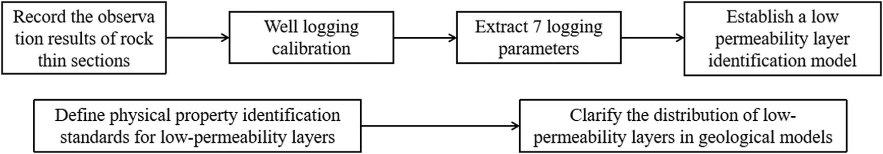
Research flowchart.
3 Results
3.1 Petrological characteristics
The results of thin section identification in the study area indicate that K1bs sandstone is mainly lithic quartz sandstone or lithic sandstone, followed by lithic feldspar sandstone (Figure 4). The primary intergranular pores are the most important type of reservoir space in the K1bs sandstone segment. The particles are mainly in point-line contact, reflecting the overall low compaction strength. The primary intergranular pores are well preserved (Figure 4). The current buried depth of the K1bs sandstone segment in the study area is about 5,000 m, which has a moderate to strong compaction degree. Its under-compaction characteristics may be related to oil and gas charging.
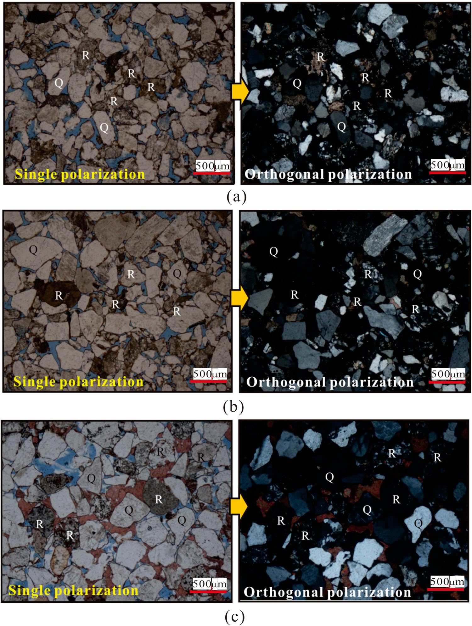
Reservoir sandstone type of K1bs formation in S3-1 block. (a) Well S3-1, 5033.57 m, cast thin section. Medium-fine-grained lithic sandstone, with medium particle sorting. The rock debris content is relatively high, which is mainly quartz siltstone debris, metamorphic quartzite debris, and granite debris. The primary intergranular pores are well preserved, and a small part is filled with early calcareous cement. In addition, a small amount of intergranular dissolution pores can be seen. (b) Well S3-1, 5043.87 m, cast thin section. Fine-medium-grained lithic sandstone, with poor particle sorting. The rock debris are mainly quartz sandstone debris, quartz siltstone debris, and granite debris. Weak chlorite rim cementation can be seen at the edges of some particles. Primary intergranular pores were well preserved. (c) Well S3-9, 5050.57 m, cast thin section. Fine-grained lithic quartz sandstone, with good particle sorting. A large number of primary intergranular pores and intergranular dissolution pores can be seen under the microscope, some of which are filled with calcareous cement, and a small amount of micro-cracks can also be seen. R, rock debris; Q, quartz.
3.2 Genesis of low-permeability layer
According to the analysis of thin sections, the development of the K1bs sandstone segment in the study area is mainly controlled by the provenance, sedimentary facies, and diagenesis. The parent rock is dominated by physical weathering, while chemical weathering is weak. Insufficient weathering results in the weathering products of the parent rock being mainly rich in detrital particles and lean in clay minerals. This kind of sandy provenance mainly is an important reason to control the development of K1bs sandstone with little muddy deposit [18,19].
The early cementation of carbonate is also an important factor in the formation of low-permeability layers in the K1bs sandstone segment (Figure 5a), which leads to a decrease in the petrophysical properties of the reservoir [20–23]. Core observations revealed that when 5% dilute hydrochloric acid was dropped on K1bs sandstone, the rock would generate bubbles, indicating that the sandstone generally contains a certain amount of calcium carbonate. Combined with the analysis results of the cast thin sections, it is found that the calcium carbonate in the sandstone mainly comes from carbonate rock debris and calcite cement. At the same time, samples with better particle sorting often have better reservoir properties. Calcite cement mainly comes from the pressure dissolution of carbonate rock debris, which mainly fills the pores between primary grains, and is the main factor leading to the densification of the reservoir [24,25]. The content of calcareous debris in different samples is quite different (Figure 5b and c). The content of carbonate rock debris in the original sediment usually determines the amount of calcite cement, which in turn determines the quality of the sand body [26–28]. The petrophysical properties of the reservoir are mainly controlled by the content and sorting of calcium debris. The formation process of the low-permeability layer is as follows: high calcium debris content → severe calcium cementation → poor sandstone physical properties → formation of low-permeability layer.
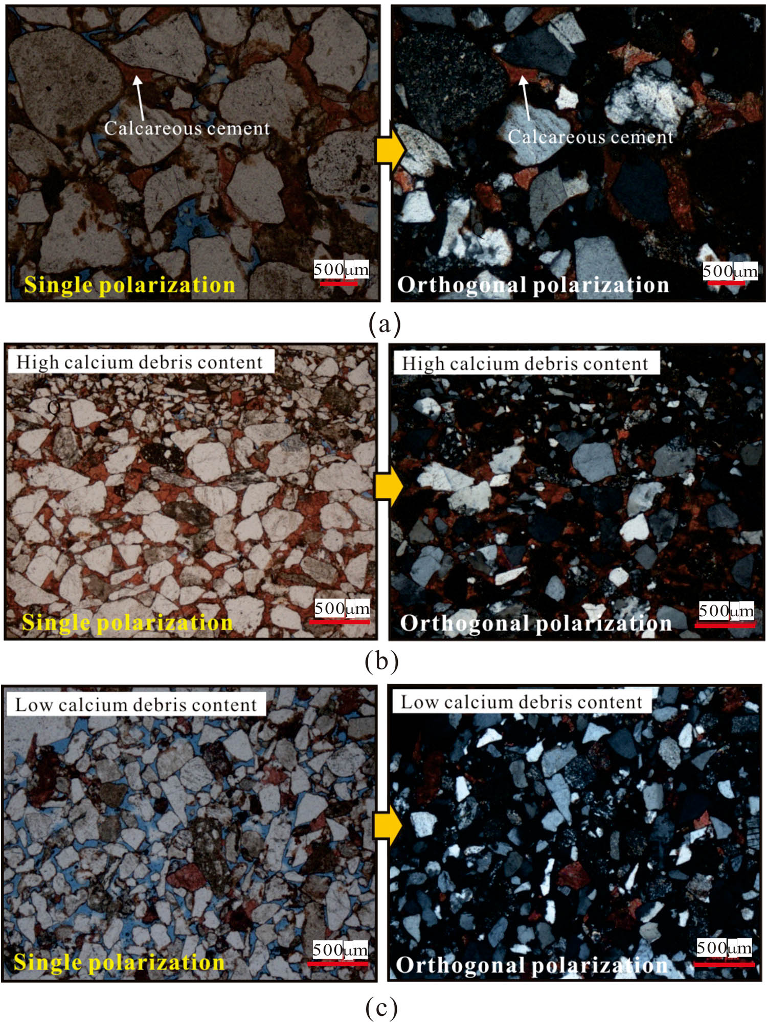
Microscopic features of calcareous cement in the K1bs sandstone segment of Block S3-1: (a) Well S3-5, 5075.69 m, (b) Well S3-1, 5018.30 m, and (c) Well S3-9, 5069.77 m.
4 Case analysis
Combined with the results of well-logging interpretation and the analysis of cast thin sections, it is found that the low-permeability layer in the K1bs sandstone section of the study area is mainly related to the content of rock debris in carbonate rocks [29,30]. The low-permeability layer rich in calcite has the characteristics of high GR, low AC value, high resistivity, and high density on the log curves. Calcareous lithic sandstone is mainly distributed in the local area in the form of interlayers, which has little effect on the overall petrophysical properties of the reservoir, but it is an important reason for the strong in-layer heterogeneity. It can be seen from the intersection of the porosity and permeability of the low-permeability layers and the high-permeability layers (Figure 6) that the correlation between the porosity and permeability of the high-permeability layers is much better than that of the low-permeability layers, reflecting the strong heterogeneity of the low-permeability layers [31,32].
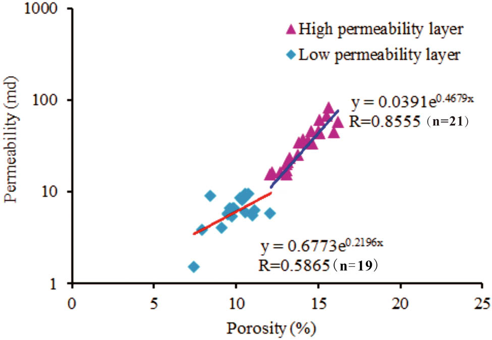
Relationship between porosity and permeability in the K1bs sandstone segment of the study area.
According to the existing full logging series, seven logging parameters Gamma Ray-Natural Radioactivity, Spontaneous Potential, Compensated Dual-Spacing Neutron Log, Density, Acoustic log, Deep Investigation Induction Log, and Medium Investigation Induction Log were extracted for analysis. Compared with the high-permeability layer, the low-permeability layer has a small compensation neutron, a large compensation density, and a relatively large GR value (Figure 7). Therefore, the intersection of GR and CNL, GR and DEN can be used to preliminarily identify the low-permeability layers.
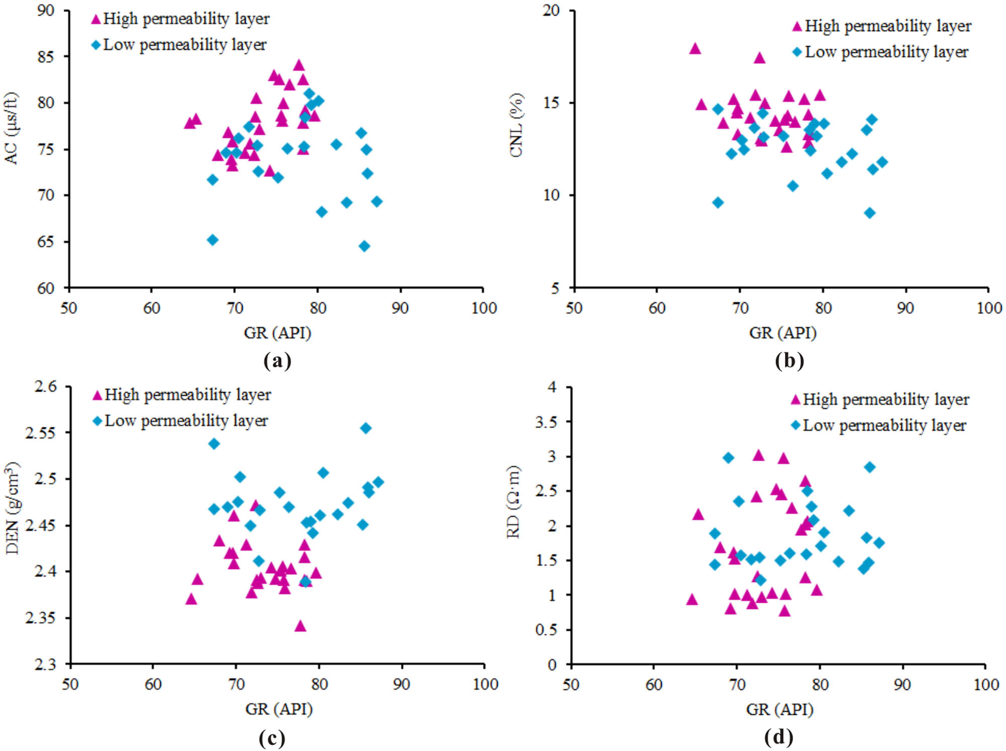
Logging response characteristics of high-permeability layer and low-permeability layer.
However, the single-parameter intersection method has low recognition accuracy for low-permeability layers. Therefore, this article selects seven logging parameters of GR, SP, CNL, DEN, AC, RILD, and RILM to judge the low-permeability layer. The multi-discrimination identification model of high-permeability layer and low-permeability layer is as follows:
According to the identification results of the low-permeability layer obtained by the multiple discriminant method, the identification effect of the initial group of low-permeability layers is 91.8%. The identification effect of the low-permeability layer in the cross-validation group is 87.8%. The initial recognition effect and cross-validation recognition effect are very good, and the model is highly reliable (Table 1).
Logging identification results of the low-permeability layers
| Formation type | Discrimination results | Discrimination rate (%) | |
|---|---|---|---|
| Number of high-permeability layers | Number of low-permeability layers | ||
| High-permeability layer | 25 | 1 | 96.15 |
| Low-permeability layer | 3 | 20 | 86.96 |
According to the recognition effect of the low-permeability layers in the K1bs sandstone segment of Well S3-1 (Figure 8), it can be found that the recognition effect of this model is good. The logging response characteristics of the low-permeability layers are obvious, and they have typical high GR, low AC, high resistivity, and high density characteristics. Combined with thin section data, we found that the low-permeability layers have the characteristics of high resistivity and high calcareous debris, which is in sharp contrast with the characteristics of the low resistivity and low calcareous debris of the high-permeability layers.
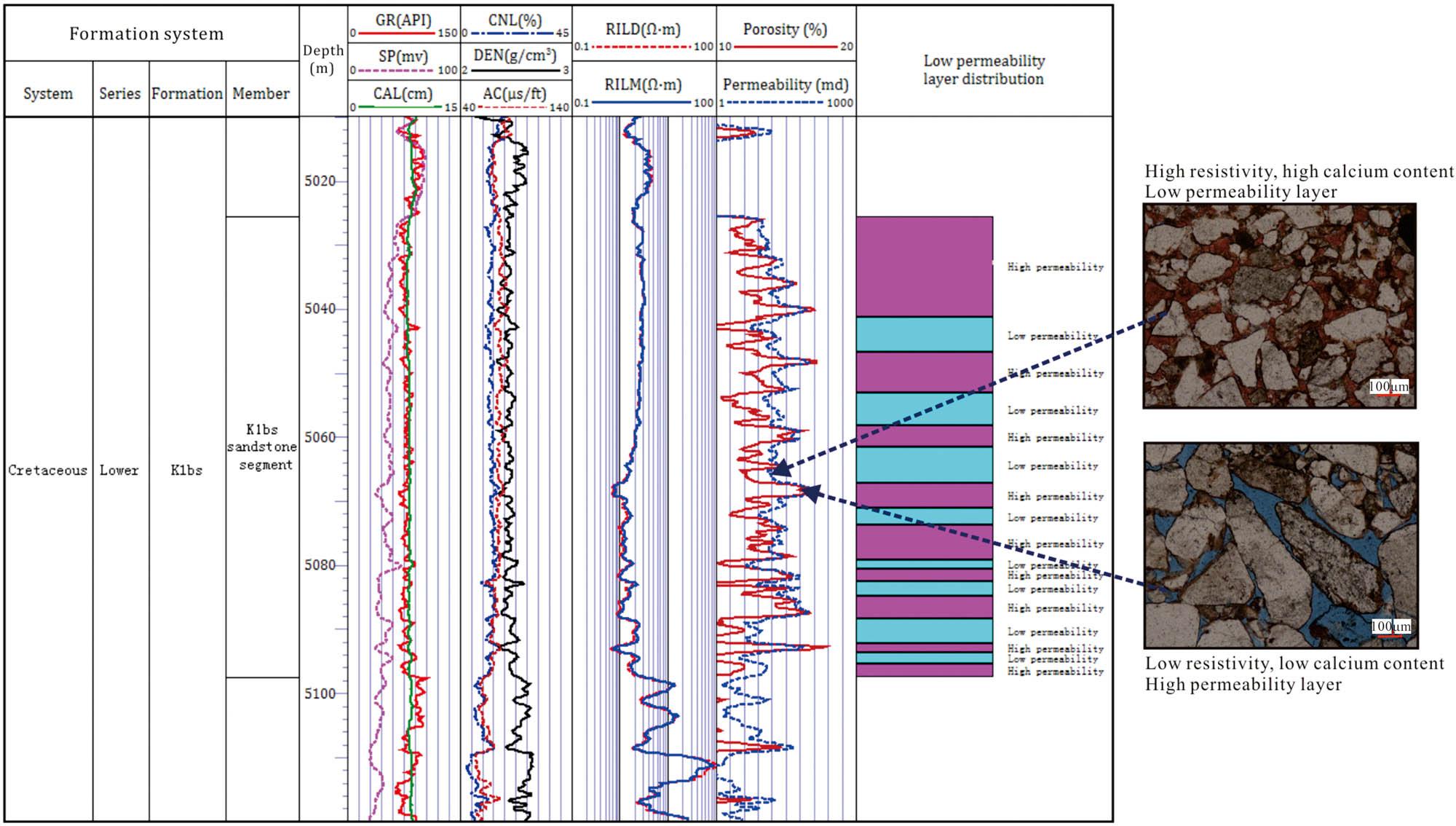
Logging identification profile of the low-permeability layer in the K1bs sandstone segment of Well S3-1.
Observing the inside of the SSC5 layer in the east–west profile, it is found that the low-permeability layer of the SSC5 layer is located at the bottom of the layer, which has a large east–west extension (Figure 9). For the north–south profile, the low-permeability layer of the SSC5 layer also has a certain extension range (Figure 9). Overall, the low-permeability layer has a small thickness, poor stability and continuity, and strong longitudinal heterogeneity, thus it can form a low-permeability baffle inside the reservoir, which greatly reduces the oil and gas migration capacity.
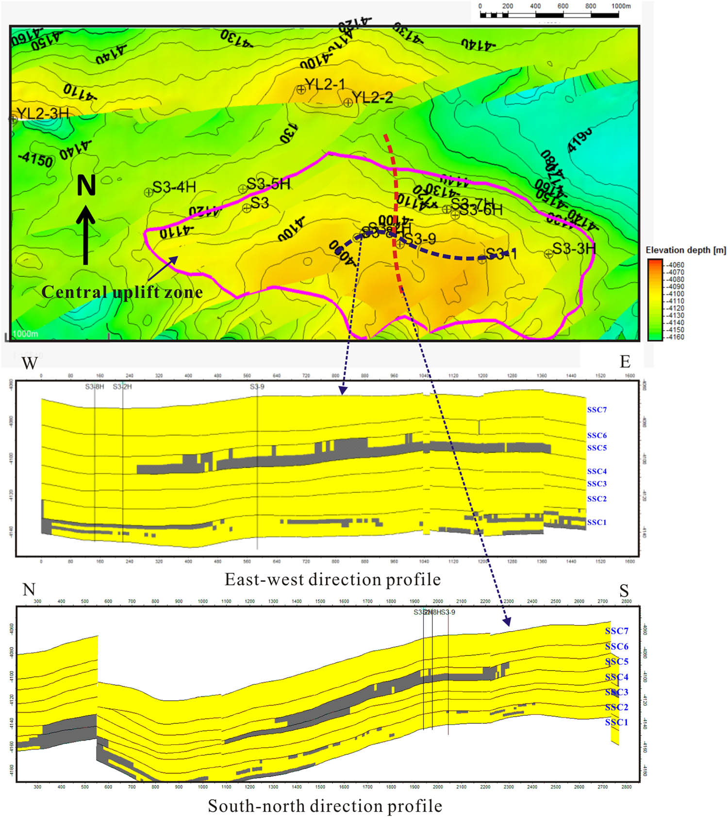
Geological modeling profile of the target layer. The gray area represents the low-permeability layer, and the yellow area represents the high-permeability layer.
5 Conclusions
High-porosity and low-permeability sandstone reservoirs are developed in the Cretaceous Bashkirchik Formation of the Luntai Uplift in the northern Tarim Basin, China. In this article, we conducted a systematic study on the geological origin and logging identification of high-porosity and low-permeability tight sandstone based on core observation, thin section, logging index response, and mathematical discrimination methods.
The K1bs sandstone segment in the study area generally contains calcium carbonate, which mainly comes from carbonate rock debris and calcite cement. Calcite cement mainly fills the pores between primary particles, and it is the main factor leading to the densification of the reservoir.
The geological origin of the formation of low-permeability layer is mainly due to the early cementation of carbonate, and the development mode of the low-permeability layer is “high content of calcium debris → severe calcium cementation → poor petrophysical properties → formation of low-permeability layer.”
The low-permeability layer has the characteristics of high gamma and high resistivity, and the multi-parameter discriminant method established based on the Fisher criterion has a good identification effect for the low-permeability layer. The low-permeability layer has a small thickness, poor stability and continuity, and strong longitudinal heterogeneity, thus it can form a low-permeability baffle inside the reservoir, which greatly reduces the oil and gas migration capacity.
Acknowledgements
This research was supported by the National Natural Science Foundation of China (Grant No. 41572130) and the National Science and Technology Major Project of China (2017ZX05035001-007).
-
Author contributions: Xie and FU: Data collection and analysis; Yin and Cai: Writing and revising the paper. Liang and Deng: Drawing and Statistics; Li and Ma: Literature research.
-
Conflict of interest: Authors state no conflict of interest.
References
[1] Dutton SP, Loucks RD. Diagenetic controls on evolution of porosity and permeability in lower Tertiary Wilcox sandstones from shallow to ultradeep (200–6700 m) burial, Gulf of Mexico Basin, U.S.A. Mar Pet Geol. 2010;27:69–81.10.1016/j.marpetgeo.2009.08.008Suche in Google Scholar
[2] Ghanizadeh G, Clarkson CR, Aquino S, Ardakani OH, Sane H. Petrophysical and geomechanical characteristics of Canadian tight oil and liquid-rich gas reservoirs: I. Pore network and permeability characterization. Fuel. 2015;153:664–81.10.1016/j.fuel.2015.03.020Suche in Google Scholar
[3] Liu J, Ding W, Wang R, Wu Z, Gong D, Wang X, et al. Quartz types in shale and their effect on geomechanical properties: an example from the lower Cambrian Niutitang Formation in the Cen’gong block, South China. Appl Clay Sci. 2018;163:100–7.10.1016/j.clay.2018.07.019Suche in Google Scholar
[4] Jiang L, Sainoki A, Mitri H, Ma N, Liu H, Hao Z,. Influence of fracture-induced weakening on coal mine gateroad stability. Int J Rock Mech Min Sci. 2016;88:307–17.10.1016/j.ijrmms.2016.04.017Suche in Google Scholar
[5] Lasaga A. Chemical kinetics of water–rock interactions. J Geophys Res. 1984;89(B6):4009–25.10.1029/JB089iB06p04009Suche in Google Scholar
[6] Haneef S, Johnson J, Thompson G, Wood G. The degradation of coupled stones by wet deposition processes. Corros Sci. 1993;34(3):497–510.10.1016/0010-938X(93)90119-2Suche in Google Scholar
[7] Li Z, Wu SH, Xia DL, Zhang XF, Huang M. Diagenetic alterations and reservoir heterogeneity within the depositional facies: a case study from distributary-channel belt sandstone of upper Triassic Yanchang formation reservoirs (Ordos Basin, China). Mar Pet Geol. 2017;86:950–71.10.1016/j.marpetgeo.2017.07.002Suche in Google Scholar
[8] Harris NB, Miskimins JL, Mnich CA. Mechanical anisotropy in the Woodford shale, Permian Basin: origin, magnitude, and scale. Lead Edge. 2011;30:284–91.10.1190/1.3567259Suche in Google Scholar
[9] Yin S, Wu Z. Geomechanical simulation of low-order fracture of tight sandstone. Mar Pet Geol. 2020;100(4):1–14.10.1016/j.marpetgeo.2020.104359Suche in Google Scholar
[10] Abdullah M, Eswaran P. Quartz surface morphology of tertiary rocks from North East Sarawak, Malaysis: implications for paleo-depositional environment and reservoir rock quality predictions. Pet Explor Dev. 2014;41(6):697–704.10.1016/S1876-3804(14)60090-2Suche in Google Scholar
[11] Yin S, Dong L, Yang X, Wang R. Experimental investigation of the petrophysical properties, minerals, elements and pore structures in tight sandstones. J Nat Gas Sci Eng. 2020;73(4):1–14.10.1016/j.jngse.2020.103189Suche in Google Scholar
[12] Anovitz LM, Cole DR. Characterization and analysis of porosity and pore structures. Rev Miner Geochem. 2015;80(1):161–4.10.2138/rmg.2015.80.04Suche in Google Scholar
[13] Bloch S, Lander RH, Bonnell L. Anomalously high porosity and permeability in deeply buried sandstone reservoirs: origin and predictability. AAPG Bull. 2002;86(2):301–28.10.1306/61EEDABC-173E-11D7-8645000102C1865DSuche in Google Scholar
[14] Morad S, Al-Ramadan K, Ketzer JM. The impact of diagenesis on the heterogeneity of sandstone reservoirs: a review of the role of depositional facies and sequence stratigraphy. AAPG Bull. 2010;94(8):1267–309.10.1306/04211009178Suche in Google Scholar
[15] Sakhaee-Pour A, Bryant SL. Effect of pore structure on the producibility of tight-gas sandstones. AAPG Bull. 2014;98:663–94.10.1306/08011312078Suche in Google Scholar
[16] Loucks RG, Reed RM, Ruppel SC, Jarvie DM. Morphology, genesis, and distribution of nanometer-scale pores in siliceous mudstones of the Mississippian Barnett shale. J Sediment Res. 2009;79:848–61.10.2110/jsr.2009.092Suche in Google Scholar
[17] Xiao D, Lu Z, Jiang S, Lu S. Comparison and integration of experimental methods to characterize the full-range pore features of tight gas sandstone – a case study in Songliao basin of China. J Nat Gas Sci Eng. 2016;34:1412–21.10.1016/j.jngse.2016.08.029Suche in Google Scholar
[18] Yin S, Tian T, Wu Z. Developmental characteristics and distribution law of fractures in a tight sandstone reservoir in a low-amplitude tectonic zone, eastern Ordos Basin, China. Geol J. 2019;54(6):1–16.Suche in Google Scholar
[19] Zou C, Zhu R, Liu K, Su L, Bai B, Zhang X, et al. Tight gas sandstone reservoirs in China: characteristics and recognition criteria. J Pet Sci Eng. 2012;88–89:82–91.10.1016/j.petrol.2012.02.001Suche in Google Scholar
[20] Shanley KW, Cluff RM. The evolution of pore-scale fluid-saturation in low permeability sandstone reservoirs. AAPG Bull. 2015;99:1957–90.10.1306/03041411168Suche in Google Scholar
[21] Torabi A, Fossen H, Braathen A. Insight into petrophysical properties of deformed sandstone reservoirs. AAPG Bull. 2013;97(4):619–37.10.1306/10031212040Suche in Google Scholar
[22] Yin S, Xie R, Wu Z, Liu J, Ding W. In situ stress heterogeneity in a highly developed strike-slip fault zone and its effect on the distribution of tight gases: a 3D finite element simulation study. Mar Pet Geol. 2019;81(1):1–17.10.1016/j.marpetgeo.2018.10.007Suche in Google Scholar
[23] Zhang X, Feng Q, Sun P, Li W,. Characteristics of high gamma ray reservoir of Yanchang formation in Ordos Basin. Chin J Geophys. 2010;53(1):205–13.10.1002/cjg2.1482Suche in Google Scholar
[24] Liu X, Wang J, Ge L, Hu F, Li C, Li X, et al. Pore-scale characterization of tight sandstone in Yanchang Formation Ordos basin China using micro-CT and SEM imaging from nm- to cm-scale. Fuel. 2017;209:254–64.10.1016/j.fuel.2017.07.068Suche in Google Scholar
[25] Wang SJ, Li XP, Schertl HP, Feng QD. Petrogenesis of early cretaceous andesite dykes in the Sulu orogenic belt, eastern China. Mineral Petrol. 2019;113(1):77–97.10.1007/s00710-018-0636-1Suche in Google Scholar
[26] Liu Y, Hu W, Cao J, Wang X, Tang Q, Wu H. Diagenetic constraints on the heterogeneity of tight sandstone reservoirs: a case study on the upper triassic Xujiahe formation in the Sichuan Basin, Southwest China. Mar Pet Geol. 2017;92:650–69.10.1016/j.marpetgeo.2017.11.027Suche in Google Scholar
[27] Nelson PH. Pore-throat sizes in sandstones, tight sandstones, and shales. AAPG Bull. 2009;93(3):329–40.10.1306/10240808059Suche in Google Scholar
[28] Yin S, Han C, Wu Z, Li Q. Developmental characteristics, influencing factors and prediction of fractures for a tight gas sandstone in a gentle structural area of the Ordos Basin, China. J Nat Gas Sci Eng. 2019;72:1–14.10.1016/j.jngse.2019.103032Suche in Google Scholar
[29] Nabawy BS, Géraud Y, Rochette P, Bur N. Pore-throat characterization in highly porous and permeable sandstones. AAPG Bull. 2009;93(6):719–39.10.1306/03160908131Suche in Google Scholar
[30] Pittman ED. Relationship of porosity and permeability to various parameters derived from mercury injectioncapillary pressure curves for sandstone. AAPG Bull. 1992;76:191–8.10.1306/BDFF87A4-1718-11D7-8645000102C1865DSuche in Google Scholar
[31] Rezaee R, Saeedi A, Clennell B. Tight gas sands permeability estimation from mercury injection capillary pressure and nuclear magnetic resonance data. J Pet Sci Eng. 2012;88−89:92–9.10.1016/j.petrol.2011.12.014Suche in Google Scholar
[32] Sapin F, Ringenbach JC, Rives T, Pubellier M. Counter-regional normal faults in shale-dominated deltas: origin, mechanism and evolution. Mar Pet Geol. 2012;37:121−8.10.1016/j.marpetgeo.2012.05.001Suche in Google Scholar
© 2024 the author(s), published by De Gruyter
This work is licensed under the Creative Commons Attribution 4.0 International License.
Artikel in diesem Heft
- Regular Articles
- Theoretical magnetotelluric response of stratiform earth consisting of alternative homogeneous and transitional layers
- The research of common drought indexes for the application to the drought monitoring in the region of Jin Sha river
- Evolutionary game analysis of government, businesses, and consumers in high-standard farmland low-carbon construction
- On the use of low-frequency passive seismic as a direct hydrocarbon indicator: A case study at Banyubang oil field, Indonesia
- Water transportation planning in connection with extreme weather conditions; case study – Port of Novi Sad, Serbia
- Zircon U–Pb ages of the Paleozoic volcaniclastic strata in the Junggar Basin, NW China
- Monitoring of mangrove forests vegetation based on optical versus microwave data: A case study western coast of Saudi Arabia
- Microfacies analysis of marine shale: A case study of the shales of the Wufeng–Longmaxi formation in the western Chongqing, Sichuan Basin, China
- Multisource remote sensing image fusion processing in plateau seismic region feature information extraction and application analysis – An example of the Menyuan Ms6.9 earthquake on January 8, 2022
- Identification of magnetic mineralogy and paleo-flow direction of the Miocene-quaternary volcanic products in the north of Lake Van, Eastern Turkey
- Impact of fully rotating steel casing bored pile on adjacent tunnels
- Adolescents’ consumption intentions toward leisure tourism in high-risk leisure environments in riverine areas
- Petrogenesis of Jurassic granitic rocks in South China Block: Implications for events related to subduction of Paleo-Pacific plate
- Differences in urban daytime and night block vitality based on mobile phone signaling data: A case study of Kunming’s urban district
- Random forest and artificial neural network-based tsunami forests classification using data fusion of Sentinel-2 and Airbus Vision-1 satellites: A case study of Garhi Chandan, Pakistan
- Integrated geophysical approach for detection and size-geometry characterization of a multiscale karst system in carbonate units, semiarid Brazil
- Spatial and temporal changes in ecosystem services value and analysis of driving factors in the Yangtze River Delta Region
- Deep fault sliding rates for Ka-Ping block of Xinjiang based on repeating earthquakes
- Improved deep learning segmentation of outdoor point clouds with different sampling strategies and using intensities
- Platform margin belt structure and sedimentation characteristics of Changxing Formation reefs on both sides of the Kaijiang-Liangping trough, eastern Sichuan Basin, China
- Enhancing attapulgite and cement-modified loess for effective landfill lining: A study on seepage prevention and Cu/Pb ion adsorption
- Flood risk assessment, a case study in an arid environment of Southeast Morocco
- Lower limits of physical properties and classification evaluation criteria of the tight reservoir in the Ahe Formation in the Dibei Area of the Kuqa depression
- Evaluation of Viaducts’ contribution to road network accessibility in the Yunnan–Guizhou area based on the node deletion method
- Permian tectonic switch of the southern Central Asian Orogenic Belt: Constraints from magmatism in the southern Alxa region, NW China
- Element geochemical differences in lower Cambrian black shales with hydrothermal sedimentation in the Yangtze block, South China
- Three-dimensional finite-memory quasi-Newton inversion of the magnetotelluric based on unstructured grids
- Obliquity-paced summer monsoon from the Shilou red clay section on the eastern Chinese Loess Plateau
- Classification and logging identification of reservoir space near the upper Ordovician pinch-out line in Tahe Oilfield
- Ultra-deep channel sand body target recognition method based on improved deep learning under UAV cluster
- New formula to determine flyrock distance on sedimentary rocks with low strength
- Assessing the ecological security of tourism in Northeast China
- Effective reservoir identification and sweet spot prediction in Chang 8 Member tight oil reservoirs in Huanjiang area, Ordos Basin
- Detecting heterogeneity of spatial accessibility to sports facilities for adolescents at fine scale: A case study in Changsha, China
- Effects of freeze–thaw cycles on soil nutrients by soft rock and sand remodeling
- Vibration prediction with a method based on the absorption property of blast-induced seismic waves: A case study
- A new look at the geodynamic development of the Ediacaran–early Cambrian forearc basalts of the Tannuola-Khamsara Island Arc (Central Asia, Russia): Conclusions from geological, geochemical, and Nd-isotope data
- Spatio-temporal analysis of the driving factors of urban land use expansion in China: A study of the Yangtze River Delta region
- Selection of Euler deconvolution solutions using the enhanced horizontal gradient and stable vertical differentiation
- Phase change of the Ordovician hydrocarbon in the Tarim Basin: A case study from the Halahatang–Shunbei area
- Using interpretative structure model and analytical network process for optimum site selection of airport locations in Delta Egypt
- Geochemistry of magnetite from Fe-skarn deposits along the central Loei Fold Belt, Thailand
- Functional typology of settlements in the Srem region, Serbia
- Hunger Games Search for the elucidation of gravity anomalies with application to geothermal energy investigations and volcanic activity studies
- Addressing incomplete tile phenomena in image tiling: Introducing the grid six-intersection model
- Evaluation and control model for resilience of water resource building system based on fuzzy comprehensive evaluation method and its application
- MIF and AHP methods for delineation of groundwater potential zones using remote sensing and GIS techniques in Tirunelveli, Tenkasi District, India
- New database for the estimation of dynamic coefficient of friction of snow
- Measuring urban growth dynamics: A study in Hue city, Vietnam
- Comparative models of support-vector machine, multilayer perceptron, and decision tree predication approaches for landslide susceptibility analysis
- Experimental study on the influence of clay content on the shear strength of silty soil and mechanism analysis
- Geosite assessment as a contribution to the sustainable development of Babušnica, Serbia
- Using fuzzy analytical hierarchy process for road transportation services management based on remote sensing and GIS technology
- Accumulation mechanism of multi-type unconventional oil and gas reservoirs in Northern China: Taking Hari Sag of the Yin’e Basin as an example
- TOC prediction of source rocks based on the convolutional neural network and logging curves – A case study of Pinghu Formation in Xihu Sag
- A method for fast detection of wind farms from remote sensing images using deep learning and geospatial analysis
- Spatial distribution and driving factors of karst rocky desertification in Southwest China based on GIS and geodetector
- Physicochemical and mineralogical composition studies of clays from Share and Tshonga areas, Northern Bida Basin, Nigeria: Implications for Geophagia
- Geochemical sedimentary records of eutrophication and environmental change in Chaohu Lake, East China
- Research progress of freeze–thaw rock using bibliometric analysis
- Mixed irrigation affects the composition and diversity of the soil bacterial community
- Examining the swelling potential of cohesive soils with high plasticity according to their index properties using GIS
- Geological genesis and identification of high-porosity and low-permeability sandstones in the Cretaceous Bashkirchik Formation, northern Tarim Basin
- Usability of PPGIS tools exemplified by geodiscussion – a tool for public participation in shaping public space
- Efficient development technology of Upper Paleozoic Lower Shihezi tight sandstone gas reservoir in northeastern Ordos Basin
- Assessment of soil resources of agricultural landscapes in Turkestan region of the Republic of Kazakhstan based on agrochemical indexes
- Evaluating the impact of DEM interpolation algorithms on relief index for soil resource management
- Petrogenetic relationship between plutonic and subvolcanic rocks in the Jurassic Shuikoushan complex, South China
- A novel workflow for shale lithology identification – A case study in the Gulong Depression, Songliao Basin, China
- Characteristics and main controlling factors of dolomite reservoirs in Fei-3 Member of Feixianguan Formation of Lower Triassic, Puguang area
- Impact of high-speed railway network on county-level accessibility and economic linkage in Jiangxi Province, China: A spatio-temporal data analysis
- Estimation model of wild fractional vegetation cover based on RGB vegetation index and its application
- Lithofacies, petrography, and geochemistry of the Lamphun oceanic plate stratigraphy: As a record of the subduction history of Paleo-Tethys in Chiang Mai-Chiang Rai Suture Zone of Thailand
- Structural features and tectonic activity of the Weihe Fault, central China
- Application of the wavelet transform and Hilbert–Huang transform in stratigraphic sequence division of Jurassic Shaximiao Formation in Southwest Sichuan Basin
- Structural detachment influences the shale gas preservation in the Wufeng-Longmaxi Formation, Northern Guizhou Province
- Distribution law of Chang 7 Member tight oil in the western Ordos Basin based on geological, logging and numerical simulation techniques
- Evaluation of alteration in the geothermal province west of Cappadocia, Türkiye: Mineralogical, petrographical, geochemical, and remote sensing data
- Numerical modeling of site response at large strains with simplified nonlinear models: Application to Lotung seismic array
- Quantitative characterization of granite failure intensity under dynamic disturbance from energy standpoint
- Characteristics of debris flow dynamics and prediction of the hazardous area in Bangou Village, Yanqing District, Beijing, China
- Rockfall mapping and susceptibility evaluation based on UAV high-resolution imagery and support vector machine method
- Statistical comparison analysis of different real-time kinematic methods for the development of photogrammetric products: CORS-RTK, CORS-RTK + PPK, RTK-DRTK2, and RTK + DRTK2 + GCP
- Hydrogeological mapping of fracture networks using earth observation data to improve rainfall–runoff modeling in arid mountains, Saudi Arabia
- Petrography and geochemistry of pegmatite and leucogranite of Ntega-Marangara area, Burundi, in relation to rare metal mineralisation
- Prediction of formation fracture pressure based on reinforcement learning and XGBoost
- Hazard zonation for potential earthquake-induced landslide in the eastern East Kunlun fault zone
- Monitoring water infiltration in multiple layers of sandstone coal mining model with cracks using ERT
- Study of the patterns of ice lake variation and the factors influencing these changes in the western Nyingchi area
- Productive conservation at the landslide prone area under the threat of rapid land cover changes
- Sedimentary processes and patterns in deposits corresponding to freshwater lake-facies of hyperpycnal flow – An experimental study based on flume depositional simulations
- Study on time-dependent injectability evaluation of mudstone considering the self-healing effect
- Detection of objects with diverse geometric shapes in GPR images using deep-learning methods
- Behavior of trace metals in sedimentary cores from marine and lacustrine environments in Algeria
- Spatiotemporal variation pattern and spatial coupling relationship between NDVI and LST in Mu Us Sandy Land
- Formation mechanism and oil-bearing properties of gravity flow sand body of Chang 63 sub-member of Yanchang Formation in Huaqing area, Ordos Basin
- Diagenesis of marine-continental transitional shale from the Upper Permian Longtan Formation in southern Sichuan Basin, China
- Vertical high-velocity structures and seismic activity in western Shandong Rise, China: Case study inspired by double-difference seismic tomography
- Spatial coupling relationship between metamorphic core complex and gold deposits: Constraints from geophysical electromagnetics
- Disparities in the geospatial allocation of public facilities from the perspective of living circles
- Research on spatial correlation structure of war heritage based on field theory. A case study of Jinzhai County, China
- Formation mechanisms of Qiaoba-Zhongdu Danxia landforms in southwestern Sichuan Province, China
- Magnetic data interpretation: Implication for structure and hydrocarbon potentiality at Delta Wadi Diit, Southeastern Egypt
- Deeply buried clastic rock diagenesis evolution mechanism of Dongdaohaizi sag in the center of Junggar fault basin, Northwest China
- Application of LS-RAPID to simulate the motion of two contrasting landslides triggered by earthquakes
- The new insight of tectonic setting in Sunda–Banda transition zone using tomography seismic. Case study: 7.1 M deep earthquake 29 August 2023
- The critical role of c and φ in ensuring stability: A study on rockfill dams
- Evidence of late quaternary activity of the Weining-Shuicheng Fault in Guizhou, China
- Extreme hydroclimatic events and response of vegetation in the eastern QTP since 10 ka
- Spatial–temporal effect of sea–land gradient on landscape pattern and ecological risk in the coastal zone: A case study of Dalian City
- Study on the influence mechanism of land use on carbon storage under multiple scenarios: A case study of Wenzhou
- A new method for identifying reservoir fluid properties based on well logging data: A case study from PL block of Bohai Bay Basin, North China
- Comparison between thermal models across the Middle Magdalena Valley, Eastern Cordillera, and Eastern Llanos basins in Colombia
- Mineralogical and elemental analysis of Kazakh coals from three mines: Preliminary insights from mode of occurrence to environmental impacts
- Chlorite-induced porosity evolution in multi-source tight sandstone reservoirs: A case study of the Shaximiao Formation in western Sichuan Basin
- Predicting stability factors for rotational failures in earth slopes and embankments using artificial intelligence techniques
- Origin of Late Cretaceous A-type granitoids in South China: Response to the rollback and retreat of the Paleo-Pacific plate
- Modification of dolomitization on reservoir spaces in reef–shoal complex: A case study of Permian Changxing Formation, Sichuan Basin, SW China
- Geological characteristics of the Daduhe gold belt, western Sichuan, China: Implications for exploration
- Rock physics model for deep coal-bed methane reservoir based on equivalent medium theory: A case study of Carboniferous-Permian in Eastern Ordos Basin
- Enhancing the total-field magnetic anomaly using the normalized source strength
- Shear wave velocity profiling of Riyadh City, Saudi Arabia, utilizing the multi-channel analysis of surface waves method
- Effect of coal facies on pore structure heterogeneity of coal measures: Quantitative characterization and comparative study
- Inversion method of organic matter content of different types of soils in black soil area based on hyperspectral indices
- Detection of seepage zones in artificial levees: A case study at the Körös River, Hungary
- Tight sandstone fluid detection technology based on multi-wave seismic data
- Characteristics and control techniques of soft rock tunnel lining cracks in high geo-stress environments: Case study of Wushaoling tunnel group
- Influence of pore structure characteristics on the Permian Shan-1 reservoir in Longdong, Southwest Ordos Basin, China
- Study on sedimentary model of Shanxi Formation – Lower Shihezi Formation in Da 17 well area of Daniudi gas field, Ordos Basin
- Multi-scenario territorial spatial simulation and dynamic changes: A case study of Jilin Province in China from 1985 to 2030
- Review Articles
- Major ascidian species with negative impacts on bivalve aquaculture: Current knowledge and future research aims
- Prediction and assessment of meteorological drought in southwest China using long short-term memory model
- Communication
- Essential questions in earth and geosciences according to large language models
- Erratum
- Erratum to “Random forest and artificial neural network-based tsunami forests classification using data fusion of Sentinel-2 and Airbus Vision-1 satellites: A case study of Garhi Chandan, Pakistan”
- Special Issue: Natural Resources and Environmental Risks: Towards a Sustainable Future - Part I
- Spatial-temporal and trend analysis of traffic accidents in AP Vojvodina (North Serbia)
- Exploring environmental awareness, knowledge, and safety: A comparative study among students in Montenegro and North Macedonia
- Determinants influencing tourists’ willingness to visit Türkiye – Impact of earthquake hazards on Serbian visitors’ preferences
- Application of remote sensing in monitoring land degradation: A case study of Stanari municipality (Bosnia and Herzegovina)
- Optimizing agricultural land use: A GIS-based assessment of suitability in the Sana River Basin, Bosnia and Herzegovina
- Assessing risk-prone areas in the Kratovska Reka catchment (North Macedonia) by integrating advanced geospatial analytics and flash flood potential index
- Analysis of the intensity of erosive processes and state of vegetation cover in the zone of influence of the Kolubara Mining Basin
- GIS-based spatial modeling of landslide susceptibility using BWM-LSI: A case study – city of Smederevo (Serbia)
- Geospatial modeling of wildfire susceptibility on a national scale in Montenegro: A comparative evaluation of F-AHP and FR methodologies
- Geosite assessment as the first step for the development of canyoning activities in North Montenegro
- Urban geoheritage and degradation risk assessment of the Sokograd fortress (Sokobanja, Eastern Serbia)
- Multi-hazard modeling of erosion and landslide susceptibility at the national scale in the example of North Macedonia
- Understanding seismic hazard resilience in Montenegro: A qualitative analysis of community preparedness and response capabilities
- Forest soil CO2 emission in Quercus robur level II monitoring site
- Characterization of glomalin proteins in soil: A potential indicator of erosion intensity
- Power of Terroir: Case study of Grašac at the Fruška Gora wine region (North Serbia)
- Special Issue: Geospatial and Environmental Dynamics - Part I
- Qualitative insights into cultural heritage protection in Serbia: Addressing legal and institutional gaps for disaster risk resilience