Formation mechanisms of Qiaoba-Zhongdu Danxia landforms in southwestern Sichuan Province, China
-
Qizhong Wang
 ,
Zhiheng Cheng
,
ShuYi Dong
,
Zhiheng Cheng
,
ShuYi Dong

Abstract
Embarking on systematics, the formation mechanisms of Danxia landforms were explained from perspectives of human activities, geography, and climate. The formation mechanisms of Qiaoba-Zhongdu Danxia landforms in the research region were systematically discussed using theories and methods in sedimentology, paleo-climatology, tectono-dynamics, and surface process dynamics. Meanwhile, approaches such as remote-sensing imagery interpretation, rock and ore identification, geochemical analysis, and interpretation of seismic profiles were also adopted. Research results show that Qiaoba-Zhongdu Danxia landforms are in the mature stage of landform evolution. The formation process involves five stages including being bred by sedimentation, rendered by paleo-environmental conditions, landscaped by tectonism, carved by geomorphologic agents, and embellished by human activities.
1 Introduction
The evolution process of landforms is influenced by geological changes or artificial action [1]. Geological changes include tectonic changes, volcanic activities, and plate tectonics [2,3]. Artificial action mainly refers to activities such as mining and geotechnical engineering [4,5,6,7,8,9]. Under the influences of various factors, it is challenging to reveal the formation mechanisms of landforms. In view of this, it is critically important to reveal the formation mechanisms of landforms.
At present, researchers have adopted numerous research means to study the formation mechanisms of landforms [10,11,12]. Kubalikova et al. [13] explored the effect of anthropogenic landforms in the sustainable landform management. In addition, mining disturbances can induce phenomena including movement of overlying strata [14,15,16,17,18], fracture of key strata, fracture propagation, and surface subsidence [19,20,21,22,23]. Therefore, Lowry et al. [24] used a landscape evolution model to evaluate landforms before and after mining and found more erosion in the landform restored from mining. Jancewicz et al. [25] discussed landform changes in urban landscapes due to industrial activities. Besides, Wei et al. [26] used indices deduced from the area, slope, and complexity of landforms to analyze spatial variability of loess landforms, thus explaining the spatio-temporal evolution. Currently, many studies have been conducted on landforms and landscapes from a single aspect [27,28,29], while the formation mechanisms of landforms are seldom investigated from multiple aspects [30]. Therefore, the formation mechanisms of Danxia landforms were analyzed from perspectives of human activities, geography.
The research region is located at the junction of Mabian Yi Autonomous County (Leshan City) and Pingshan County (Yibin City) at the southwest margin of Sichuan Basin. The region is controlled by subtropical mountain stereoscopic climate with ample water resources, developed vegetation, and abundant tourism landscape resources and is mainly inhabited by the Yi nationality. However, limited by the locational conditions, the region is relatively economically backward. The research region of Qiaoba-Zhongdu Danxia landforms (103°34′20″E ∼ 104°E, 28°39′59″N ∼ 28°59′47″N) covers an area of 1,540 km2 (the research range for spatial distribution characteristics of Danxia landforms is mainly within the range where Danxia landforms are exposed, i.e., 103°38′E ∼ 103°51′E, 28°43′5″N ∼ 28°49′6″N).
According to the division scheme of geotectonic units in Sichuan Province, the primary, secondary, and tertiary geotectonic units in the research region of Qiaoba-Zhongdu Danxia landforms belong to the Yangtze block, upper Yangtze block, and Sichuan foreland basin, respectively. The quaternary geotectonic units are divided into two zones: the southwest and north parts of the research region of Qiaoba-Zhongdu Danxia landforms belong to the Junlian-Xuyong superposed fold belt and Weiyuan uplift, respectively.
Permian, Triassic, Jurassic, and Cretaceous strata are widely developed in the research region of Qiaoba-Zhongdu Danxia landforms. Mesozoic strata are developed relatively completely, in which various strata are all exposed. Jurassic and Cretaceous strata are widely distributed. Meanwhile, influenced by multistage tectonic movements, the research region of Qiaoba-Zhongdu Danxia landforms is found to have complex structural features and developed folds and faults. According to the correlation and spatial distribution of structures in the research region of Qiaoba-Zhongdu Danxia landforms and surrounding areas, the region can be divided into four tectonic systems: a nearly NS-trending tectonic system, a nearly EW-trending tectonic system, a NE tectonic system, and an arc tectonic system (Figure 1).

Regional structural outline map (adapted from Mabian map sheet at the scale of 1:500,000). (1) Wuzhishan anticline, (2) Dianlanba syncline, (3) Mabian syncline, (4) Lidian-Xinfan syncline, (5) Kuchang anticline, (6) Muchuan anticline, (7) Sieshan complex anticline, (8) Chenziyan-Shakuang anticline, (9) Jinyan anticline, (10) Liumacao anticline, (11) Shunhe syncline, (12) Shuanghekou syncline, (13) Gubai anticline, (14) Wajiaoluo syncline, (15) Waga anticline, (16) Waheikou syncline, (17) Xiaoyaozi anticline, (18) Sanhekou syncline, (19) Jiuba anticline, (20) Shibeigang syncline, (21) Sanjiaosi inverted anticlinorium, and (22) Dayingpan anticlinorium.
2 Methodology
The distribution and evolution process of Danxia landforms in the research region of Qiaoba-Zhongdu Danxia landforms were studied by combining indoor and outdoor methods. Indoor research was mainly performed by means of remote-sensing imagery interpretation and hypsometric integral (HI), while the outdoor work mainly studied the spatial distribution characteristics and landform evolution stages of Danxia landforms through field survey.
Satellite data used in the remote-sensing imagery interpretation were single-scene multi-band Landset-8 OLI images downloaded from the geospatial data cloud with the spatial resolution of 30 m. The image data were collected in 2018, with cloud proportion lower than 10% of the whole images. The data showed high quality and met the research requirements.
The spatial resolution of the Landsat8 satellite was 30 m, for which the projected coordinate system was WGS_1984_UTM_Zone_48N. After downloading images, preprocessing operations including radiometric calibration, atmospheric correction, image fusion, and image cropping were performed in ENVI5.3, followed by interpretation and relevant information extraction.
Intense neotectonics and frequent earthquakes have happened in the research region of Qiaoba-Zhongdu Danxia landforms. Due to profound influences of neotectonics on failure of landforms, the evolution stages of Danxia landforms cannot be simply judged based on existing landforms. Therefore, the quantitative and qualitative methods were combined to judge landform evolution stages. The qualitative method followed the division principle for landform evolution proposed by Peng et al. [31] and the HI model was applied in quantitative calculation. During HI calculation of areas, the landform development pattern of Davies was quantified. Combined with HI value of areas, landform evolution was divided into three stages [32]: the infant stage (HI > 0.6), mature stage (0.4 < HI < 0.6), and old stage (HI < 0.4). The HI model of areas was solved using the method of relief ratio put forward by Pike and Wilson [33], as shown below:
where HIwatershed is the HI value of small watersheds; H a is the mean raster value of watersheds; H s is the minimum raster value of watersheds; H m is the maximum raster value of watersheds; HItotal is the HI value of the research region of Qiaoba-Zhongdu Danxia landforms; and f is the number of watersheds divided.
To reveal paleo-environmental conditions for sedimentation of Danxia strata, the paleosalinity, paleoclimate, redox properties of paleo-sedimentary media, and characteristics of material sources were analyzed via rock and ore identification and geochemical analysis of elements. The paleo-environmental conditions for formation of Danxia red-beds were reproduced.
According to the composition analysis scheme for clastic rocks proposed by Zeng and Tan [34], 24 samples were collected (23 were valid) to analyze the climatic index (F/Q) and structural index (L/Q) in the research region of Qiaoba-Zhongdu Danxia landforms.
3 Results
3.1 Spatial distribution characteristics of Danxia landforms
The remote sensing information is decoded as shown in Figure 2. Remote-sensing imagery interpretation and field survey found that Qiaoba-Zhongdu Danxia landforms are mainly distributed along river systems including Qiaoba river, Zhongdu river, Longqiao river, and Shuiping stream. Meanwhile, numerous landscapes such as cliffs, long walls, stone pillars, and stone walls of Danxia landforms are developed at the nearly right-angle corner in the research region of Qiaoba-Zhongdu Danxia landforms. On the whole, Qiaoba-Zhongdu Danxia landforms are mainly characterized by spatial distribution along river systems, nearly right-angle corner, and fault zones, as well as exposure in areas of a large slope and topographic relief.

Spatial distribution characteristics of Danxia landforms. (a) Mountain shadow interpretation. (b) Topographic relief interpretation. (c) Interpretation of elevation and river systems. (d) Slope-aspect shadow interpretation.
3.2 Landform evolution stages
ArcGIS platform was adopted to extract watersheds. Under the runoff confluence of 5,000, 40 small watersheds were extracted from the research region of Qiaoba-Zhongdu Danxia landforms. HIwatershed of the 40 small watersheds was calculated to be between 0.30 and 0.60 and HItotal of the research region of Qiaoba-Zhongdu Danxia landforms was 0.43 (Table 1). This indicates that the region is in the mature to old stage while HItotal suggests that the region is in the mature stage on the whole. Through comprehensive judgement of landform types including peak clusters, stone walls, and stone pillars developed in Danxia landforms in the research region of Qiaoba-Zhongdu Danxia landforms, Qiaoba-Zhongdu Danxia landforms are generally in the mature stage of landform evolution.
HI calculation table
| Watershed number | Watershed area (m2) | H s | H m | H a | HIwatershed | HItotal |
|---|---|---|---|---|---|---|
| 1 | 5,965,200 | 744 | 1,336 | 998.96 | 0.43 | 0.43 |
| 2 | 3,548,700 | 719 | 1,234 | 908.82 | 0.37 | |
| 3 | 6,759,900 | 692 | 1,337 | 973.99 | 0.44 | |
| 4 | 1,198,800 | 631 | 1,059 | 872.77 | 0.56 | |
| 5 | 2,356,200 | 619 | 1,072 | 842.31 | 0.49 | |
| 6 | 6,534,000 | 792 | 1,316 | 1008.68 | 0.41 | |
| 7 | 2,558,700 | 857 | 1,334 | 1035.05 | 0.37 | |
| 8 | 558,900 | 761 | 1,038 | 880.28 | 0.43 | |
| 9 | 9,916,200 | 847 | 1,535 | 1054.59 | 0.30 | |
| 10 | 5,841,900 | 698 | 1,377 | 931.45 | 0.34 | |
| 11 | 3,267,000 | 823 | 1,124 | 932.67 | 0.36 | |
| 12 | 2,733,300 | 755 | 1,307 | 932.12 | 0.32 | |
| 13 | 3,919,500 | 918 | 1,531 | 1100.10 | 0.30 | |
| 14 | 6,336,000 | 775 | 1,330 | 981.83 | 0.37 | |
| 15 | 1,035,900 | 872 | 1,094 | 957.79 | 0.39 | |
| 16 | 3,528,900 | 731 | 1,594 | 1064.97 | 0.39 | |
| 17 | 11,347,200 | 581 | 1,559 | 1010.05 | 0.44 | |
| 18 | 1,189,800 | 918 | 1,129 | 997.38 | 0.38 | |
| 19 | 2,561,400 | 874 | 1,238 | 1046.87 | 0.47 | |
| 20 | 3,813,300 | 948 | 1,453 | 1165.30 | 0.43 | |
| 21 | 4,511,700 | 745 | 1,684 | 1264.19 | 0.55 | |
| 22 | 10,732,500 | 628 | 1,681 | 1220.17 | 0.56 | |
| 23 | 4,047,300 | 828 | 1,594 | 1141.00 | 0.41 | |
| 24 | 11,509,200 | 783 | 1,682 | 1233.51 | 0.50 | |
| 25 | 229,500 | 916 | 1,003 | 962.26 | 0.53 | |
| 26 | 2,448,000 | 1,093 | 1,681 | 1349.74 | 0.44 | |
| 27 | 1,629,000 | 1,111 | 1,700 | 1389.32 | 0.47 | |
| 28 | 4,597,200 | 944 | 1,447 | 1144.85 | 0.40 | |
| 29 | 7,978,500 | 945 | 1,685 | 1292.20 | 0.47 | |
| 30 | 1,247,400 | 1,063 | 1,417 | 1210.05 | 0.42 | |
| 31 | 162,000 | 1,245 | 1,616 | 1468.37 | 0.60 | |
| 32 | 16,451,100 | 629 | 1,617 | 1085.21 | 0.46 | |
| 33 | 6,372,000 | 919 | 1,533 | 1153.61 | 0.38 | |
| 34 | 2,437,200 | 901 | 1,417 | 1168.98 | 0.52 | |
| 35 | 3,876,300 | 765 | 1,387 | 1040.97 | 0.44 | |
| 36 | 3,492,000 | 762 | 1,337 | 970.78 | 0.36 | |
| 37 | 306,000 | 839 | 986 | 907.55 | 0.47 | |
| 38 | 2,999,700 | 815 | 1,394 | 1103.42 | 0.50 | |
| 39 | 1,570,500 | 1,003 | 1,465 | 1200.77 | 0.43 | |
| 40 | 6,676,200 | 996 | 1,552 | 1235.76 | 0.43 |
4 Discussion
4.1 Formation mechanisms of Danxia landforms
4.1.1 Landscape-breeding effect of sedimentation
With regard to lithology, Wotoushan formation mainly includes brick-red thick to ultra-thick medium-grained feldspar quartz sandstone, boulder-clay-bearing medium- and coarse-grained feldspar quartz sandstone, and medium- and fine-grained feldspar quartz sandstone interbedded with a small amount of brick-red medium to thin argillaceous fine siltstone and thin silty mudstone (Figure 3a, b). The stratigraphic sequences are developed as types I and II in Figure 4. Parallel beddings and large-scale oblique beddings are developed in sandstone, and the bottom of sandstone generally bears brick-red boulder clay. Brick-red thick to ultra-thick sandstone and boulder-clay-bearing sandstone are mainly present as braided stream deposits. Horizontal beddings, sand-ripple beddings, worm trails, and desiccation cracks are developed in mudstone and silty mudstone, which are mainly flood deposits. They are developed as type III in Figure 4 in terms of stratigraphic sequences.

Field outcrops of Wotoushan formation. (a) Sandstone interbedded with mudstone (mirror image 318). (b) Interbedded conglomerate (mirror image 200).

Stratigraphic sequences of Wotoushan formation (adapted from Dianlanba map sheet at the scale of 1:50,000). (a) Boulder-clay-bearing feldspar quartz sandstone. (b) Feldspar quartz sandstone. (c) Argillaceous siltstone. (d) Silty mudstone. (e) Argillaceous sandstone. (1) Bottom scour. (2) Oblique beddings. (3) Parallel beddings. (4) Horizontal beddings. (5) Sand-ripple beddings.
By identifying the rock samples collected in the research region of Qiaoba-Zhongdu Danxia landforms under a microscope, the sandstone in the region is found to bear medium- to fine-grained and fine-grained sandstone, with the particle size of 0.1–0.3 mm, and its sortability and roundness are somewhat between poor and moderate levels. The rock samples contain quartz (50–69%), feldspar (5–21%), and rock debris (3–19%). The secondary debris contains mica, calcite, glauconite, and volcanic glass. Cementation modes include siliceous cementation, ferruginous cementation, and calcite cementation, among which calcite cementation is more frequently seen. Sandstone is mainly grain-supported with porous cementation (Figure 5). The differences in SiO2, CaO, and Fe2O3 contents greatly affect the weathering resistance of Danxia landforms and the color difference of Danxia red-beds, whole-rock geochemical analysis was performed on samples [35,36]. Results show that the SiO2, CaO, and Fe2O3 contents are in the ranges of 37–82%, 0.57–21.14%, and 1.12–3.29%, respectively. The result indicates that rocks at different geologic horizons of Wotoushan formation contain obviously different contents of SiO2, CaO, and Fe2O3.

Microscopic images (+) of sandstone in Wotoushan formation (adapted from four map sheets of Muchuan County at the scale of 1:50,000). Ls: Sedimentary rock debris. Q: Quartz. Cal: Carbonate. Pl: Plagioclase. Kfs: Potassium feldspar. F: Feldspar. Ser: Sericite. Mns: Muscovite. (a) PM4-BP13. (b) PM4-BP16. (c) PM4-BP19. and (d) PM4-BP23.
The research has shown that sedimentation bred the early form of Danxia landforms, lithological difference provides a material basis for formation of such landforms, and sedimentary tectonic types enrich elements of landforms and landscapes.
The lithological composition of Danxia landforms plays a crucial role in their formation and evolution, particularly through the weathering processes influenced by SiO2, CaO, and Fe2O3 contents.
Previous studies have shown that high SiO2 content in sedimentary rocks, such as quartz sandstones, significantly increases their resistance to chemical weathering while making them susceptible to mechanical weathering due to their brittle nature [35,36]. In the Danxia landforms, the high silica content supports the preservation of sharp ridges and steep cliffs by reducing the rate of chemical weathering, allowing mechanical weathering (e.g., freeze-thaw cycles and thermal expansion) to dominate the landscape’s sculpting processes. This resistance to chemical weathering helps maintain the prominent vertical structures characteristic of Danxia landforms.
On the other hand, rocks with higher CaO content are more prone to chemical weathering, especially carbonation, which dissolves calcium carbonate through interaction with water and atmospheric CO2. In the context of Danxia landforms, the layers with elevated CaO content undergo more rapid erosion, contributing to the formation of valleys and flatter surfaces. This differential weathering, where calcium-rich layers erode faster than more silica-rich strata, plays a vital role in the distinctive topographical contrast between peaks and valleys in Danxia landscapes.
The presence of Fe2O3 is not only responsible for the red coloration of Danxia landforms but also plays a role in the weathering resistance. Iron oxidation can lead to the formation of hard iron oxide crusts on the rock surface, temporarily protecting the underlying rock from further weathering. However, as these crusts eventually break down, the underlying softer rock is exposed, further contributing to the shaping of the landforms. This alternating process of protection and exposure adds to the complexity of the erosion patterns observed in Danxia landforms.
In summary, the lithological composition, particularly the levels of SiO2, CaO, and Fe2O3, directly influences the weathering processes that shape Danxia landforms. High SiO2 content enhances the resistance to chemical weathering, while CaO accelerates chemical degradation, leading to differential erosion. Fe2O3 contributes to surface protection through crust formation and the characteristic red hue of the landscape. These findings reinforce understanding of how these components collectively contribute to the evolution of the unique topographical features of Danxia landforms.
4.1.2 Rendering effect of paleo-environmental conditions
4.1.2.1 Paleosalinity
Sr, Ba, and Sr/Ba ratio are commonly used as indicators of paleosalinity [37]. On this basis (Table 2), it is judged that the sedimentary water body was freshwater [38]. However, when analyzing changes in the Sr curve, the Sr value reached a maximum of 248.6 × 10⁻⁶ in the late stage, indicating that droughts might occur in the period. The Sr/Ba curve also varied abruptly in the late stage, which suggests an increase in the salinity of sedimentary water body in the period. This probably resulted from the substantial increase in water evaporation and remarkable concentration of water, which to some extent indicates that temperature might rise obviously and therefore temperature-rise events occurred (Figure 6).
Sr, Ba, and Sr/Ba ratio
| Name | Content | Average |
|---|---|---|
| Sr | 88.5 × 10⁻⁶–248.6 × 10⁻⁶ | 127.8 × 10⁻⁶ |
| Ba | 216.6 × 10⁻⁶–503 × 10−6 | 319.76 × 10⁻⁶ |
| Sr/Ba | 0.31–0.77 | 0.41 |

Paleosalinity. (a) Sr/Ba analysis graph. (b) Sr/Ba variation curve; (c) Sr variation curve.
4.1.2.2 Redox properties of paleo-sedimentary media
Outliers for masses of U, V, Cr, Mo, Co, Th, Fe3+, Mn, as well as rare-earth elements Eu and Ce, were adopted to comprehensively discriminate redox properties of paleo-sedimentary media in the research region of Qiaoba-Zhongdu Danxia landforms based on multiple indices [39] (Table 3).
Calculation results of discrimination indices for redox environments of paleo-sedimentary media of Wotoushan formation in the research region of Qiaoba-Zhongdu Danxia landforms
| U/Th | V/Cr | Ni/Co | V/(V + Ni) | Fe2+/Fe3+ | EFMn | EFU | Ce/Ce* | Eu/Eu* | |
|---|---|---|---|---|---|---|---|---|---|
| PM4-DX1 | 0.20 | 0.69 | 2.45 | 0.70 | 1.13 | 2.04 | 1.61 | 0.86 | 0.68 |
| PM4-DX2 | 0.17 | 0.55 | 2.15 | 0.54 | 0.27 | 2.86 | 1.00 | 0.87 | 0.69 |
| PM4-DX3 | 0.23 | 0.39 | 2.33 | 0.64 | 0.42 | 0.83 | 0.72 | 0.84 | 0.83 |
| PM4-DX4 | 0.23 | 0.71 | 1.98 | 0.67 | 0.34 | 1.01 | 0.74 | 0.83 | 0.82 |
| PM4-DX5 | 0.22 | 0.53 | 2.49 | 0.69 | 0.51 | 1.18 | 0.67 | 0.80 | 0.78 |
| PM4-DX6 | 0.19 | 0.80 | 1.76 | 0.75 | 0.46 | 1.34 | 0.93 | 0.86 | 0.76 |
| PM4-DX7 | 0.20 | 0.57 | 1.76 | 0.73 | 0.76 | 0.85 | 0.87 | 1.01 | 0.76 |
| PM4-DX8 | 0.21 | 0.89 | 1.92 | 0.71 | 0.65 | 0.78 | 0.84 | 0.81 | 0.77 |
| PM4-DX9 | 0.21 | 0.97 | 1.82 | 0.75 | 1.06 | 0.71 | 0.73 | 0.82 | 0.76 |
| PM4-DX10 | 0.18 | 0.75 | 1.71 | 0.73 | 0.72 | 0.82 | 1.03 | 0.84 | 0.67 |
| PM4-DX11 | 0.33 | 1.32 | 1.80 | 0.77 | 2.92 | 1.46 | 2.28 | 0.90 | 0.70 |
| PM4-DX12 | 0.21 | 0.89 | 2.37 | 0.69 | 0.90 | 1.30 | 0.77 | 0.72 | 0.78 |
| Mean value | 0.22 | 0.75 | 2.05 | 0.70 | 0.85 | 1.27 | 1.02 | 0.85 | 0.75 |
Ce* and Ue* are theoretical Ce and Ue values derived from normalized rare earth element (REE) models for spherical meteorites.
Enhanced factor of molybdenum and enhanced factor of uranium (EFU) are in the ranges of 4.53–82.66 (19.43 on average) and 0.67–2.28, respectively. Analysis of U and Mo suggests an oxidizing paleo-sedimentary environment. Research on U/Th (Figure 7a), V/(V + Ni) (Figure 7b), V/Cr (Figure 7c), and Ni/Co (Figure 7d) [40], as well as on Fe2+/Fe3+, enhanced factor of manganese, and Eu/Eu* shows that the paleo-sedimentary environment of Wotoushan formation in the research region of Qiaoba-Zhongdu Danxia landforms was an oxidizing environment (Figure 7).

Redox properties of sedimentary water body. (a) U/Th. (b) V/(V + Ni). (c) V/Cr. (d) Ni/Co.
4.1.2.3 Paleoclimate discrimination
Detrital composition analysis
Results show that in the late sedimentation stage of Wotoushan formation, F/Q and L/Q were in the ranges of 16.6–35% (21.7% on average) and 3.3–34% (16.6% on average), respectively; F/Q is larger than L/Q on the whole. This indicates that the sedimentary environment in the period was controlled by the climate. Moreover, F/Q of Wotoushan formation exhibited a gradual increasing trend in the entire sedimentation process, indicating that the climate gradually became arid.
Geochemical discrimination of elements
The paleoclimate was discriminated through multi-factor comparative analysis of geochemistry of elements [41]. Comprehensive multi-factor comparative analysis can maximally offset the discrimination error incurred by different grain sizes due to subjective sampling.
Changes in contents of macro-elements K2O, Na2O, CaO, Al2O3, and Fe2O3 in Wotoushan formation were compared with those in the adjacent region (Table 4). This reveals that Wotoushan formation sedimented in an arid-hot environment, and extreme drought events took place in the middle and late sedimentation stages (Figure 8).
Analysis and calculation table of macronutrients
| No. ω (B)/10−2 | SiO2 | Al2O3 | TFe2O3 | Fe2O3 | FeO | MgO | CaO | Na2O | K2O | TiO2 | MnO | P2O5 | LOI | Al2O3/MgO | FeO/MnO | FeO/Fe2O3 | CIA | ICV |
|---|---|---|---|---|---|---|---|---|---|---|---|---|---|---|---|---|---|---|
| PM4-DH1 | 78.41 | 9.92 | 3.89 | 1.96 | 1.73 | 0.63 | 0.59 | 3.79 | 0.90 | 0.61 | 0.16 | 0.15 | 1.22 | 15.67 | 10.98 | 0.88 | 0.58 | 1.10 |
| PM4-DH2 | 65.78 | 8.90 | 10.49 | 2.05 | 7.60 | 0.82 | 4.79 | 2.58 | 1.27 | 0.44 | 0.22 | 0.12 | 4.10 | 10.91 | 34.26 | 3.71 | 0.52 | 1.38 |
| PM4-DH3 | 73.63 | 6.79 | 4.37 | 1.19 | 2.86 | 0.83 | 5.26 | 2.03 | 1.11 | 0.35 | 0.064 | 0.071 | 4.83 | 8.14 | 44.41 | 2.40 | 0.51 | 1.43 |
| PM4-DH4 | 73.18 | 6.94 | 5.79 | 1.35 | 4.00 | 0.90 | 5.29 | 2.03 | 1.12 | 0.38 | 0.079 | 0.074 | 4.44 | 7.70 | 50.92 | 2.97 | 0.52 | 1.45 |
| PM4-DH5 | 67.50 | 7.55 | 3.85 | 1.22 | 2.37 | 1.13 | 8.35 | 1.87 | 1.41 | 0.29 | 0.091 | 0.084 | 8.07 | 6.71 | 25.96 | 1.95 | 0.55 | 1.34 |
| PM4-DH6 | 61.67 | 8.12 | 7.45 | 2.19 | 4.74 | 1.31 | 8.82 | 2.13 | 1.09 | 0.74 | 0.10 | 0.15 | 8.27 | 6.18 | 45.58 | 2.16 | 0.55 | 1.51 |
| PM4-DH7 | 82.01 | 7.59 | 3.86 | 1.57 | 2.06 | 0.63 | 0.57 | 2.22 | 1.57 | 0.41 | 0.066 | 0.089 | 1.16 | 12.01 | 31.50 | 1.32 | 0.62 | 1.03 |
| PM4-DH8 | 66.00 | 7.64 | 3.48 | 1.29 | 1.97 | 1.36 | 9.01 | 2.23 | 1.52 | 0.38 | 0.060 | 0.089 | 8.17 | 5.61 | 32.71 | 1.53 | 0.50 | 1.64 |
| PM4-DH9 | 65.70 | 6.67 | 2.29 | 1.12 | 1.05 | 0.92 | 10.98 | 2.01 | 1.45 | 0.30 | 0.055 | 0.077 | 9.68 | 7.25 | 19.18 | 0.94 | 0.51 | 1.47 |
| PM4-DH10 | 62.60 | 6.69 | 3.31 | 1.31 | 1.81 | 1.21 | 11.44 | 1.82 | 1.41 | 0.45 | 0.064 | 0.095 | 10.56 | 5.52 | 28.29 | 1.38 | 0.52 | 1.58 |
| PM4-DH11 | 37.73 | 9.99 | 4.54 | 3.29 | 1.13 | 2.01 | 21.14 | 0.63 | 2.52 | 0.49 | 0.11 | 0.097 | 20.64 | 4.98 | 9.95 | 0.34 | 0.83 | 0.99 |
| PM4-DH12 | 62.56 | 6.36 | 2.51 | 1.12 | 1.24 | 0.51 | 13.25 | 1.53 | 1.48 | 0.28 | 0.10 | 0.081 | 11.36 | 12.53 | 12.36 | 1.11 | 0.58 | 1.09 |
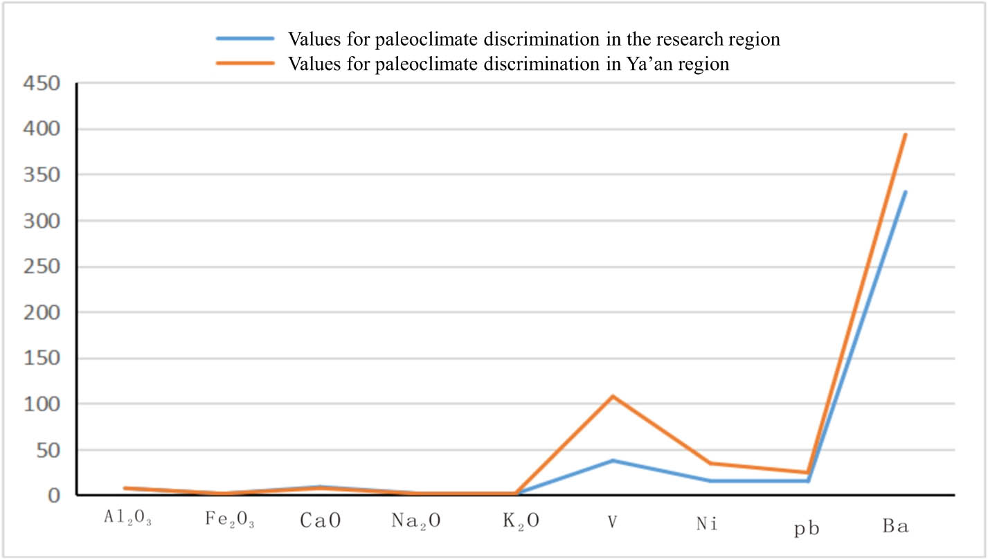
Comparison of relevant elements for paleoclimate discrimination in the research region of Qiaoba-Zhongdu Danxia landforms and adjacent region.
For micro-elements, Ni and Pb contents in the research region of Qiaoba-Zhongdu Danxia landforms are both lower than the average Ni content (34.7 × 10⁻⁶, arid climate) in Cretaceous Guankou formation in the adjacent Ya’an prefecture in Sichuan Province. This suggests the arid climate during sedimentation (Table 5).
Trace element analysis and calculation table
| No. ω (B)/10−6 | Ag | As | Ba | Cd | Co | Cr | Cu | Hf | Mo | Ni | Pb | Re | Rb |
|---|---|---|---|---|---|---|---|---|---|---|---|---|---|
| PM4-DH1 | 0.055 | 2.60 | 201.8 | 0.30 | 8.64 | 72.6 | 26.5 | 8.26 | 8.68 | 21.2 | 28.11 | <0.01 | 40.37 |
| PM4-DH2 | 0.105 | 3.79 | 216.6 | 0.38 | 15.12 | 69.4 | 44.3 | 5.55 | 66.13 | 32.5 | 19.41 | <0.01 | 46.70 |
| PM4-DH3 | 0.063 | 2.75 | 248.8 | 0.15 | 6.16 | 65.6 | 24.9 | 4.11 | 13.39 | 14.4 | 12.79 | <0.01 | 35.36 |
| PM4-DH4 | 0.067 | 3.32 | 253.5 | 0.18 | 7.85 | 43.6 | 25.5 | 3.86 | 21.64 | 15.6 | 14.40 | <0.01 | 37.91 |
| PM4-DH5 | 0.065 | 2.75 | 343.5 | 0.24 | 5.83 | 59.4 | 21.0 | 3.18 | 12.10 | 14.5 | 16.97 | <0.01 | 46.60 |
| PM4-DH6 | 0.077 | 3.51 | 503.0 | 0.26 | 10.05 | 66.0 | 27.5 | 5.99 | 26.21 | 17.7 | 18.44 | <0.01 | 33.53 |
| PM4-DH7 | 0.089 | 2.45 | 374.7 | 0.15 | 7.24 | 59.1 | 24.1 | 6.20 | 9.76 | 12.7 | 14.06 | <0.01 | 51.23 |
| PM4-DH8 | 0.076 | 1.49 | 367.8 | 0.20 | 6.42 | 34.5 | 18.6 | 4.35 | 8.02 | 12.4 | 16.76 | <0.01 | 57.57 |
| PM4-DH9 | 0.069 | 1.64 | 330.9 | 0.20 | 4.33 | 24.9 | 11.9 | 4.15 | 3.62 | 7.9 | 14.63 | <0.01 | 53.48 |
| PM4-DH10 | 0.093 | 1.47 | 312.0 | 0.17 | 5.85 | 36.8 | 17.5 | 8.47 | 7.23 | 10.0 | 12.54 | 0.01 | 50.78 |
| PM4-DH11 | 0.332 | 28.9 | 324.4 | 0.26 | 12.03 | 54.9 | 21.7 | 3.68 | 3.97 | 21.7 | 11.68 | 0.03 | 106.87 |
| PM4-DH12 | 0.097 | 2.16 | 360.2 | 0.21 | 4.80 | 28.3 | 12.8 | 4.81 | 5.74 | 11.4 | 11.62 | <0.01 | 56.09 |
| No. ω (B)/10−6 | Sb | Sr | Th | U | V | Zn | Zr | Sr/Ba | U/Th | V/Cr | Ni/Co | V/V + Ni | Sr/Cu |
|---|---|---|---|---|---|---|---|---|---|---|---|---|---|
| PM4-DH1 | 1.08 | 83.6 | 10.52 | 2.09 | 49.9 | 45.9 | 332.8 | 0.41 | 0.20 | 0.69 | 2.45 | 0.70 | 3.16 |
| PM4-DH2 | 1.18 | 118.9 | 7.50 | 1.29 | 38.0 | 64.1 | 210.5 | 0.55 | 0.17 | 0.55 | 2.15 | 0.54 | 2.69 |
| PM4-DH3 | 0.79 | 97.3 | 3.97 | 0.93 | 25.5 | 22.1 | 141.2 | 0.39 | 0.23 | 0.39 | 2.33 | 0.64 | 3.91 |
| PM4-DH4 | 0.90 | 97.4 | 4.19 | 0.97 | 31.1 | 24.8 | 133.3 | 0.38 | 0.23 | 0.71 | 1.98 | 0.67 | 3.82 |
| PM4-DH5 | 0.66 | 124.7 | 3.90 | 0.87 | 31.6 | 34.4 | 97.6 | 0.36 | 0.22 | 0.53 | 2.49 | 0.69 | 5.95 |
| PM4-DH6 | 0.90 | 154.9 | 6.25 | 1.20 | 52.6 | 32.3 | 217.4 | 0.31 | 0.19 | 0.80 | 1.76 | 0.75 | 5.62 |
| PM4-DH7 | 0.46 | 88.5 | 5.78 | 1.13 | 33.9 | 25.5 | 239.1 | 0.24 | 0.20 | 0.57 | 1.76 | 0.73 | 3.67 |
| PM4-DH8 | 1.16 | 126.6 | 5.24 | 1.09 | 30.7 | 32.4 | 150.0 | 0.34 | 0.21 | 0.89 | 1.92 | 0.71 | 6.82 |
| PM4-DH9 | 0.76 | 142.5 | 4.58 | 0.95 | 24.1 | 22.2 | 141.1 | 0.43 | 0.21 | 0.97 | 1.82 | 0.75 | 11.99 |
| PM4-DH10 | 0.45 | 136.3 | 7.30 | 1.34 | 27.7 | 25.9 | 333.5 | 0.44 | 0.18 | 0.75 | 1.71 | 0.73 | 7.81 |
| PM4-DH11 | 0.84 | 248.6 | 9.01 | 2.96 | 72.5 | 67.9 | 112.7 | 0.77 | 0.33 | 1.32 | 1.80 | 0.77 | 11.47 |
| PM4-DH12 | 0.38 | 113.8 | 4.67 | 1.00 | 25.1 | 21.9 | 164.7 | 0.32 | 0.21 | 0.89 | 2.37 | 0.69 | 8.88 |
Analysis of relevant ratios reveals that Sr/Cu, FeO/MnO, Al2O3/MgO, SiO2- (Al2O3 + K2O + Na2O), SiO2/Al2O3, Na2O/K2O, SiO2/(Al2O3 + Fe2O3), and FeO/Fe2O3 [42,43] all perform well in discriminating paleoclimate. The research found that the climate of research region of Qiaoba-Zhongdu Danxia landforms was warm and wet in the early period while it was so arid in the late period that extreme drought events happened.
In summary, Wotoushan formation in the research region of Qiaoba-Zhongdu Danxia landforms was controlled by structures in the early sedimentation stage while by climate in the late sedimentation stage. The conditions allowed sedimentation of a formation dominated by sandstone and interbedded with slight siltstone and mudstone. The climate in the period showed arid to semi-arid characteristics, and was arid-hot on the whole. It was wet in the early period while hot and arid in the late period, accompanied by extreme arid events.
4.1.2.4 Characteristics of material sources
Chemical index of alteration (CIA) calculation (Figure 9a) [44] and Th/U (Figure 9b) [45], Ni–TiO2 (Figure 9c) [46], and Hf-La/Th (Figure 9d) [47] analysis indicate weak weathering in the source areas. The upper crust was probably the major source area and sediment sources were mainly quartz-feldspathic rocks (Figure 8).

Analysis of material sources for the research region of Qiaoba-Zhongdu Danxia landforms. (a) Sandstone Th/U-Th. (b) CIA-index of compositional variability. (c) TiO2/Ni. (d) La/Th-Hf.
The tectonic setting of source areas was also studied. Th-Co-Hf/10 suggests that the tectonic setting was continental-island arcs and passive continental margins; La/Th diagram indicates that the tectonic setting was continental-island arcs (Figure 9d). Rare earth elements characteristics [48] of sandstone in different tectonic settings were compared with those of sandstone in Wotoushan formation. The result reveals that the tectonic setting of source areas in the research region of Qiaoba-Zhongdu Danxia landforms was continental-island arcs and passive continental margins. According to regional geological background, Songpan-Ganzi block at the west margin of Yangtze plate was always at the continental-island arc for a long geological history [49], and the western part of Sichuan Basin was at the passive continental margin in different geological periods [50,51]. Therefore, it is comprehensively inferred that Songpan-Ganzi region was the sediment source area for Wotoushan formation (Figure 9).
4.1.3 Landscaping effect of tectonism
Landforms and landscapes are results of the coupling effect of tectonism, climate environment, and landforms. Research on the tectonism and discussion of the tectonic evolution process help reveal the formation process of landforms. Generally, Danxia landforms in the research region of Qiaoba-Zhongdu Danxia landforms are nearly V-shaped on the NS vertical sections and distributed as a right-angle corner on the plane. To further study their control factors, neotectonics and tectonic evolution process in the research region of Qiaoba-Zhongdu Danxia landforms were discussed, thus revealing the landscaping effect of tectonism on landforms.
4.1.3.1 Neotectonics
Neotectonics in the research region of Qiaoba-Zhongdu Danxia landforms were dominated by large areas of periodic and intermittent uplifting, accompanied by faulting and earthquakes. Field survey and analysis reveal that three levels of planation surfaces are present in the research region of Qiaoba-Zhongdu Danxia landforms and I–IV river terraces are developed and retained in Yangjia Village, Jianshe Township, Mabian County. Additionally, lots of deeply incised meanders are developed in the research region of Qiaoba-Zhongdu Danxia landforms.
4.1.3.2 Tectonic formation and evolution
Tectonic deformation mechanism
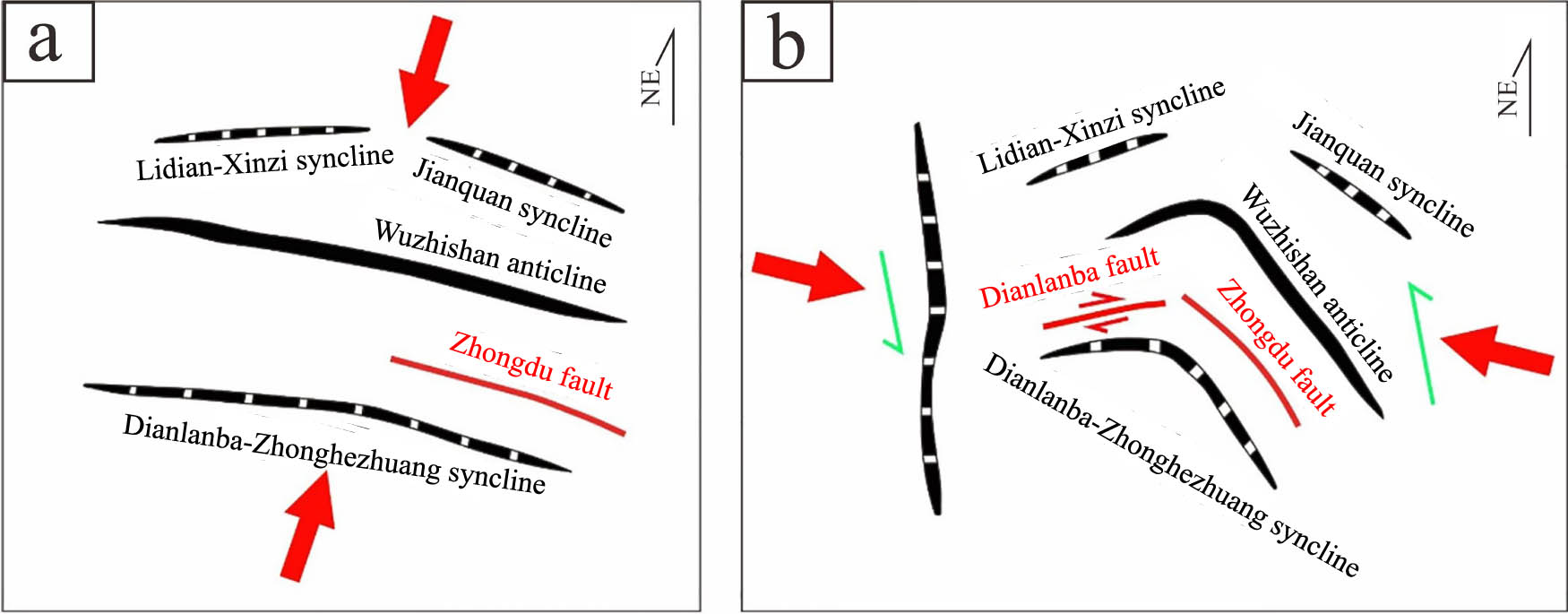
Research on main structures in the research region of Qiaoba-Zhongdu Danxia landforms found that synclines nearly parallel to Wuzhishan anticline are distributed in both north and south sides of the anticline. These synclines exhibit gentle fold features (the interlimb angle is generally larger than 150°) and have a larger and wider interlimb angle than anticlines in the same series. This combination of closed anticlines while gentle synclines conforms to the partition-style folds [52,53]. Interpretation results of seismic profiles suggest that Wuzhishan anticline is generally characterized by decollement folds, and the basement decollement layer at fold cores is thickened. Except for thickness changes in Cambrian system that serves as the cover-decollement layer, other formations as the cover strata do not change obviously in the thickness. Both wings of folds beneath Cambrian system are symmetric. Above Cambrian system, the northeast wing is slightly steeper than the southwest wing due to the transformation effect of faults in cover strata on folds. Therefore, the NEE- and NW-trending anticlinal folds represented by Wuzhishan anticline in the research region of Qiaoba-Zhongdu Danxia landforms are decollement folds formed under the control of basal bedding faults (Figure 10). Formation of such structural system is probably a result of propagation and development of orogenesis from the southwest margin to the inward of Sichuan Basin (Figure 11).

Interpretation diagram of a seismic profile passing through Wuzhishan anticline (refer to Figure 1 for location of profiles a and b).

The partition-style folds formed by NEE- and NW-trending folds and the possible formation mechanism.
As mentioned above, structural features in the research region of Qiaoba-Zhongdu Danxia landforms can mainly be summarized into two types of fold systems: (1) the NEE- and NW-trending fold system and (2) NS-trending fold system. The two are obviously superposed, with the NS-trending thrust fault (Lidian fault) obviously cutting Wuzhishan anticline. This implies that the NEE- and NW-trending structures were formed in the early period, while NS-trending structure superposed in the late period.
According to the relationship between strain and background stress field, the main part of the NEE- and NW-trending structure reflects shortening along the NS direction, which corresponds to the NS compressive stress field; the structural feature of the main part of the NS-trending structure reflects shortening along the EW direction, corresponding to the EW compressive stress field. The NEE and NW folds might have affected all the stratigraphic units except the quaternary unlike the NS-trending folds that affected all the stratigraphic units with no exception. While the NS-trending folds also affected Quaternary system apart from influencing all stratigraphic units of bed rocks. This also demonstrates the precedence relationship of the two.
Tectonic deformation stages
(1) Compressional deformation stage. By summarizing the tectonic evolution history of Yangtze plate, the plate is found to have a significant correspondence with tectonic deformation in the research region of Qiaoba-Zhongdu Danxia landforms. Therein, Indosinian movements correspond to aggregation of an array of terranes to the south margin of Yangtze plate from south to north. The evolution process started from Late Triassic and periodically persisted to Late Cretaceous [54]. Subduction of Indosinian plate to Yangtze plate from Middle Jurassic to Late Cretaceous had entered the hard collision period of continental collision. The southward subduction of continental crusts of Yangtze plate caused the fold-thrust nappe system to further develop towards the inland. As a result, nearly WE-trending folds and surface uplifts were formed in the research region of Qiaoba-Zhongdu Danxia landforms, so that a parallel unconformity tectonic movement surface occurred, with Middle Jurassic Shaximiao formation overburden on Early Jurassic Ziliujing formation. The principal stress in the stage was mainly along the SSW-NNE direction, forming a series of folds and reverse faults such as Lidian-Xinzi syncline, Jianquan syncline, Wuzhishan anticline, Dianlanba-Zhonghezhuang syncline, and Zhongdu fault with NNW-SSE-trending hinge lines.
(2) Compressional and strike-slip deformation stage. The main body of relatively late Himalayan movements originated from Qinghai-Tibet plateau uplifting and its expansion towards the periphery, which were caused by northward aggregation of Indian Plate to the south margin of Eurasian plate. At the southwest margin of Yangtze plate in the research region of Qiaoba-Zhongdu Danxia landforms, activities in Himalayan period were mainly shown as shortening along the EW direction, accompanied by strike-slip faulting. So, the research region of Qiaoba-Zhongdu Danxia landforms was just in the frontal zone for tectonic deformation in Himalayan period to further develop eastward. This caused formation of numerous NS-trending structural features, which were also concentratedly evinced in neotectonics. The principal stress during tectonism in the research region of Qiaoba-Zhongdu Danxia landforms in the stage was mainly along the NNW-SEE direction. A series of strike-slip reverse faults have been formed due to influences of collision orogeny between Indian plate and Eurasian plate since Cenozoic, which also changed the direction of hinge lines of existing folds. The hinge lines of some folds were folded again under stress in the period. The structural development patterns in the period were also the most important control factor for the development of landforms and river systems in the research region of Qiaoba-Zhongdu Danxia landforms (Figure 12).
Schematic diagram or two-stage evolution of Dianlanba-Zhonghezhuang syncline (adapted from four map sheets of Muchuan County at the scale of 1:50,000). (a) Compressional deformation stage. (b) Compressional and strike-slip deformation stage.
In summary, tectonism in the research region of Qiaoba-Zhongdu Danxia landforms controlled the regional spatial patterns. Influenced by nearly NS-trending stress compression in the early period and nearly EW-trending stress compression in the late period, the landform pattern nearly shaped as a right-angle corner was formed on the plane. Both the wings of nearly WE-trending Dianlanba-Zhonghezhuang syncline formed under nearly NS-trending stress in the early period had different orientations (steep in the north while gentle in the south). It was the orientation difference that caused differential denudation of landforms in the late period, showing the nearly V-shaped profile pattern of the current landforms. Various tectonic structures formed by tectonism, including river terraces, meandering streams, and escarpments enriched landscape elements of Danxia landforms in the research region of Qiaoba-Zhongdu Danxia landforms. In the meantime, the diverse joints and fractures formed due to tectonic movements enlarged the air contact surfaces of rocks, providing wider places for weathering and fluvial denudation and offering sites for the formation of Danxia landforms.
4.1.4 Carving effect of geomorphologic agents
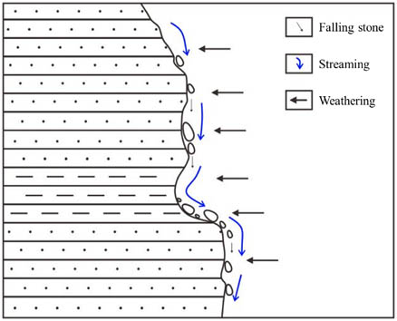
According to geomorphological research, formation of landforms is a result of joint action of internal and external drivers. If internal drivers as regarded to play a large-scale macroscopic (there are also micro-scale landforms shaped by tectonism) landscaping effect in the formation process of landforms, geomorphologic agents mainly play a role in meso-microscopically (relative to the influence range of tectonism) carving landforms. In the process, internal drivers shaped main contours of landforms through large-scale dynamic transformation. Geomorphologic agents modify landforms combining with different climate and environment conditions, finally forming marvelous Danxia landforms such as cliffs, waterfalls, valleys, pillars, and caverns in all shapes and forms. Additionally, the research region of Qiaoba-Zhongdu Danxia landforms receives abundant rainfall and features developed surface runoffs and surface river systems. Meanwhile, the research region of Qiaoba-Zhongdu Danxia landforms experienced frequent tectonic movements and earthquakes, which developed joints and fractures in rocks. Geomorphologic agents for forming Danxia landforms in the region mainly include weathering, fluvial erosion, and collapse (Table 6) and the developed Danxia landforms include diverse cliffs, caverns, potholes, waterfalls, and rocks.
Main geomorphologic agents in the research region of Qiaoba-Zhongdu Danxia landforms
 |
4.1.4.1 Caverns
In Qiaoba-Zhongdu region, some glutenite, conglomerate with medium to thick fine-grained sandstone, and siltstone are interbedded on precipices. Due to differences of lithology and thermal expansion coefficients, the rocks expanded under wet and thermal conditions while shrank under dry and cold conditions with the diurnal temperature variation, which produced bedding and trans-bedding joints. They caused weathering of precipices, which mainly occurred along strata such as siltstone, sandstone, and pebbly sandstone, as well as at locations with dense intraformational joints and fractures. Finally, grooves, forehead-shaped caverns, flat-shaped caverns, through-going caverns, all kinds of overlapped caverns, and catenulate caverns were formed (Table 7).
Formation and evolution of caverns
| Cavern types | Formation process | Major causes | Evolution | |
|---|---|---|---|---|
| Horizontal rock tanks | Due to lithological difference, grooves were formed by differential weathering of precipices. Then, weathering, fluvial erosion, and collapse further intensified, forming caverns in diverse types, such as forehead-shaped caverns, flat-shaped caverns, through-going caverns, and natural bridges. | Lithological difference |
 |
 |
| Forehead-shaped caverns | Weathering Fluvial erosion |
 |
 |
|
| Flat-shaped caverns | Collapse |
 |
 |
|
4.1.4.2 Potholes
Potholes are developed in the research region of Qiaoba-Zhongdu Danxia landforms. They are distributed widely along Qiaoba River section. Potholes along Qiaoba river were numbered, measured, and studied. A total of 39 standard potholes were measured. The research found that potholes are basically small ones with the maximum and minimum long axes of 93 and 9 cm, and the maximum and minimum short axes of 68 and 8 cm, respectively. The average lengths of the long and short axes are 39 and 30 cm, respectively. In terms of shapes, potholes along Qiaoba river are mainly pot-like with a large mouth, small pot belly, and round bottom (V-shaped shallow holes with a large amount and small pot belly) and in U shape with basically the same sizes of the mouth and belly (Table 8). As for the strike of long axes, the long axes of potholes mainly stretch along four directions: NNW, NNE, NE, and NEE, which are hardly overlapped with the dominated joint directions of bed rocks. This indicates that joints and fractures are only local control factors for formation of potholes in the research region of Qiaoba-Zhongdu Danxia landforms, rather than leading factors.
Pothole shapes
| Long axis (L 1) | 65 | 57 | 26 | 19 | 80 | 18 | 25 | 25 | 37 | 9 | 28 | 48 | 39 | 22 | 37 | 34 | 46 | 20 | 30 | 47 |
| Short axis (L S) | 45 | 48 | 17 | 18 | 60 | 14 | 25 | 18 | 31 | 8 | 23 | 35 | 30 | 20 | 32 | 30 | 35 | 17 | 19 | 33 |
| Direction of long axis | 57 | 50 | 38 | 47 | 82 | 83 | 16 | 25 | 333 | 4 | 35 | 351 | 12 | 6 | 347 | 6 | 35 | 340 | 15 | 5 |
| Oblateness (X) | 0.31 | 0.16 | 0.35 | 0.05 | 0.25 | 0.22 | 0.0 | 0.28 | 0.16 | 0.11 | 0.18 | 0.27 | 0.23 | 0.09 | 0.14 | 0.12 | 0.24 | 0.15 | 0.37 | 0.3 |
| Long axis (L 1) | 90 | 19 | 50 | 48 | 93 | 72 | 63 | 19 | 18 | 17 | 25 | 47 | 21 | 24 | 54 | 24 | 46 | 32 | 30 | — |
| Short axis (L S) | 68 | 16 | 32 | 43 | 33 | 39 | 55 | 17 | 15 | 14 | 19 | 42 | 18 | 21 | 50 | 20 | 43 | 19 | 24 | — |
| Direction of long axis | 10 | 19 | 15 | 38 | 15 | 25 | 5 | 353 | 5 | 15 | 13 | 15 | 6 | 10 | 3 | 1 | 350 | 60 | 35 | — |
| Oblateness (X) | 0.24 | 0.16 | 0.36 | 0.10 | 0.65 | 0.46 | 0.13 | 0.11 | 0.17 | 0.18 | 0.24 | 0.11 | 0.14 | 0.13 | 0.07 | 0.17 | 0.07 | 0.41 | 0.20 | — |
Based on locations of river beds with potholes, rotating water flows observed in potholes, and residual sand and pebbles on the bottom of potholes in the research region of Qiaoba-Zhongdu Danxia landforms and combined with hydrodynamic analysis, potholes in Qiaoba-Zhongdu Danxia landforms were formed due to abrasion of river beds by sand and pebbles carried by water flows. Because hydrodynamic conditions changed randomly, the formed craters differed in the width and height, thus forming V-, U-, and inverted Ω-shaped potholes on the river beds. Individual potholes roughly experienced an evolution process from the early form (formative period), V-, U-, and inverted Ω-shaped potholes (development period), and potholes with broken and residual walls (extinction period). Combined potholes underwent an evolution process from impact craters, overlapped potholes (formed in special environments), connected potholes, convergent potholes, catenulate potholes to arc-walled grooved river beds (Table 9).
Pothole types
 |
The research found that formation of fluvial potholes in the research region of Qiaoba-Zhongdu Danxia landforms was related to the hydro-dynamism, tectonic conditions, bed loads, and lithology. These factors either act alone or jointly to finally create potholes in different shapes.
4.1.4.3 Waterfalls
Danxia waterfalls are pervasive in the research region of Qiaoba-Zhongdu Danxia landforms, including waterfall of Longqiao river, Gaodongzi waterfall, and Piaoshuiyan waterfall. According to the formation mechanisms, these waterfalls are divided into threshold and knickpoint ones. The waterfall of Longqiao river and Piaoshuiyan waterfall were studied in field (Table 10).
Typical waterfall types in the research region of Qiaoba-Zhongdu Danxia landforms
| Waterfall types | Formation process | Causes | Evolution |
|---|---|---|---|
| Threshold waterfalls | They are formed due to lithological difference. Due to different erosion resistances of soft and hard strata, thresholds were formed, which further developed to waterfalls. | Lithological difference |
 |
| Tectonism | |||
| Knickpoint waterfalls | Knickpoints were formed due to headward erosion. Knickpoints enlarged the fall of river beds, thus forming waterfalls. | Fluvial erosion |
 |
4.1.4.4 Rocks
Numerous vertical joints are developed in the gently dip red-beds in the research region of Qiaoba-Zhongdu Danxia landforms, which cut rocks into blocks. The mountain blocks extend along the fracture lineament (large-scale joints). When rocks in both sides collapse, the remaining parts look like thin walls, in which tall and short ones are separately called stone walls and stone beams of Danxia landforms. Isolated peaks remaining in the process form stone pillars of Danxia landforms.
4.1.5 Embellishment effect of human activities
Landscapes are explained as comprehensive characteristics of a region in Encyclopedia of China – Geography, including aspects such as the nature, economy, and culture. According to the explanation, landscapes are results of joint action of natural environments and human activities and represent how object reality is summarized and defined according to human’s aesthetic taste. Landscapes unify natural and social attributes. Therefore, the formation process of landforms not only includes the self-shaping of tectonism, but also cannot be separated from the participation and transformation of human activities. In this process, the special values (scientific research value and aesthetic value) of landforms themselves determined by geological processes are the natural basis for becoming landscapes. Then, social, economic, and cultural attributes are assigned to landforms by human activities. Landforms do not simply show a single value any longer, but become a complex constituted by the cognition, emotion, tendency, and value of human in the process of understanding and transforming the nature. They are a contradictory unity between human’s subjective cognition and objective world. Human activities play a principal part in shaping landforms and embellishing geological landscapes in the process (due to the limited ability of human in transforming the nature and the development idea of respecting the nature and following the natural law, human transforms the original landforms with restraint according to their demand. Such moderate and limited transformation on the basis of original landforms to meet human demands under conditions of spatial and temporal elements is called the embellishment effect of human activities on geological landscapes). Apart from this, cognition of human is also integrated in landforms to become an indispensable part. The embellishment effect of human activities on landforms was studied from four aspects: historic cultural activities, ethnic cultural activities, religious cultural activities, and agricultural production activities.
4.1.5.1 Historical cultural activities enrich landscape elements
Diverse colorful historical footprints have been left in Qiaoba-Zhongdu region, as represented by ancient Shu civilization, culture of Three Kingdoms, and Tea-Horse culture. At present, historical sites including Shizhangkong cliff and the ancient Tea-Horse Road (Figure 13a) are still remaining. These historical sites have been integrated and mutually accomplished with historical culture, expanding values and enriching elements of Danxia landscapes.

Landscape embellishment by human activities. (a) The ancient Tea-Horse Road. (b) Wang’s Grand Courtyard. (c) Ming Wang temple. (d) Rape flower field in Zhongdu Township.
4.1.5.2 Ethnic cultural activities impart landscape characteristics
Zhongdu Township (Pingshan County, Yibin City, Sichuan Province, China) was known as Yidu in history and was an important residence zone of the Yi nationality (a general term for ethnic minorities in history). It was originally the fief of a subline of Yufu King. Yidu was renamed as Zhongdu in the seventeenth year of Wanli Empery in the Ming Dynasty and was a famous imperial city in history. At present, two caverns can be seen in a far distance on the Guanyintang cliff at Fangmaba in Zhongdu Township, which are dubbed as Longhu caverns by local people. Local residents in Qiaoba-Zhongdu region are mainly the Yi nationality. They build their hometown with their hard-working hands and keep pace with the times to promote the ethnic culture of the Yi nationality while inheriting the culture. The prosperity of the ancient Yi culture can be explored from the ruins of the imperial city. By visiting the ruins of Wang’s Grand Courtyard, one can experience the residential characteristics and realize how prosperous the family culture was (Figure 13b). The reborn Yi culture that keeps up with the times can be seen in modern dwellings with special characteristics in Manao Miao village and new village of Yi nationality in Yanfeng Township. All these marks, either tangible or intangible, manifest local characteristics with their special features.
4.1.5.3 Religious cultural activities add charms to landscapes
The traditional religion of the Yi nationality belongs to the primitive religious system. The local people believe the presence of supernatural gods. Legends passed down by word of mouth and recorded myth and legend system are popular in the region. There are also complete sacrificial ceremonies and witchcraft, Bimo with special ability, and Rebu of different functions. The local people have totemism, nature worship, and ancestor worship; local-God temple, stone tiger; land-God pillar, totem pole, and fengshui tower all bear the plainest philosophic concept of the Yi nationality. With the migration of ancestors of the Yi nationality and the prosperity of the central plain culture, the religious culture of the Yi nationality has exchanged and integrated with the central plain culture and finally thrived in the region. For example, there are still many historical sites of temples, including Beifang temple, Jiaolong temple, Leng Yan temple, Ming Wang temple, Heilong local-God temple, Wugu temple, and Giant Buddha of the Eight Immortal Mountains in Longhua Township. These historical sites not only embody the essence of traditional construction art and create a special atmosphere of religious culture, but also enrich landscape elements and add charms to landscapes in the research region of Qiaoba-Zhongdu Danxia landforms (Figure 13c).
4.1.5.4 Agricultural production activities broaden the dimension of landscapes
Agricultural production is the main production activities in Qiaoba-Zhongdu region, where traditional small family farming is prevalent and mountain paths are ubiquitous. Large-scale and industrialized development mode of modern agricultural production can also be seen, as exemplified by the sunflower base in Mingjian village. New farming modes led by the modern thought of integration of agriculture and tourism can also be experienced, such as the mysterious area in Zhongdu County – the 10,000 Mu of rape flower fields (Figure 13d).
4.1.6 Impact of climate
Danxia Mountain has a humid climate, and abundant rainfall is very conducive to the weathering and stripping of rock layers, which plays an important role in promoting the formation of Danxia Mountain landscape. Rain, surface water, and groundwater erosion are an important external power conditions for the formation of Danxia landscape. The long-term scouring of the river on the red layer, combined with lateral erosion and undercutting, has led to the formation of the distinctive shapes characteristic of the Danxia landscape. Among them, the undercutting of the flowing water to form a deep canyon, lateral erosion is constantly hollowing out the foot of the slope, so that the rock overhangs the formation of dangerous rocks, and further collapse [55].
In addition, the formation of micro geomorphology of caves on steep cliffs is closely related to the warm and moist climatic environment. When caves on steep cliffs expand to a certain scale, due to the shading of sunlight and airflow by the roof edge, a microclimate different from the outside will be formed inside the cave, and it is easier for moist water vapor to be kept in the cave for a longer period of time, so that the interior of the cave is softened and the process of weathering is accelerated [56].
4.2 Formation process of Danxia landforms
The formation of Qiaoba-Zhongdu Danxia landforms experienced sedimentation of red-beds, tectonic uplifts, fluvial erosion, weathering denudation, geomorphic shaping, and so on.
4.2.1 Formation of red-beds
According to the tectonic evolution process of Sichuan Basin, Late Indosinian epeirogeny completely ended the marine sedimentary history of Yangtze platform and rose to land. Afterwards, Yanshanian cycle starting from Late Triassic (Rhaetian) and ending in Paleocene Eocene introduced Sichuan Basin into the formation, development, and extinction stages of large inland basins by the intermittent differential vertical lifting of blocks [57].
In Late Jurassic-Early Cretaceous, the climate of Sichuan Basin gradually altered from warm and wet to arid and hot. The oscillating settling velocity of crusts was relatively balanced. In the period, Sichuan Basin expanded to an inland basin in the maximum flooding period and received widely distributed terrigenous clastic rock deposits [58].
From Early to Late Cretaceous (Late Yanshanian episode), the sedimentation center in western Sichuan Province migrated southwestward to Ya’an-Lushan region under the NW-SE compression, and the southern section of Longmen Mountain rapidly uplifted to become main material sources of the basin. In the period, influenced by differential block lifting during episode II of Yanshanian movements in southwestern Sichuan Province, Luding-Miyi anteklise and Liangshan platform depression in the middle of Xikang-Yunnan axis were synchronously uplifted as horsts onto the lake surface, denudated and lost the lower Cretaceous strata. Two graben basins, namely, Mishi (Xichang)-Jiangzhou and Muchuan-Guanyinchang (Yibin) basins between three horst-like uplifts (Luding-Miyi, Liangshan, Central Sichuan uplifts) were filled with red coarse clastic sedimentary construction of ultra-thick Cretaceous Wotoushan formation.
The research region of Qiaoba-Zhongdu Danxia landforms is situated in Muchuan-Guanyinchang (Yibin) synclinal basin. Influenced by hydro-dynamism and paleo-environment during sedimentation, fluvial deposits of braided streams and meandering streams were developed in Cretaceous Wotoushan formation. In the period, ferruginous rocks in clastic deposits were chemically weathered to form ferric oxides in the dry and oxidizing sedimentary environment. The ferric oxides constantly spread to gradually dye deposits into iron red and therefore, formed red clastic series, which laid the material basis for Danxia landforms in the region (Figure 14a).
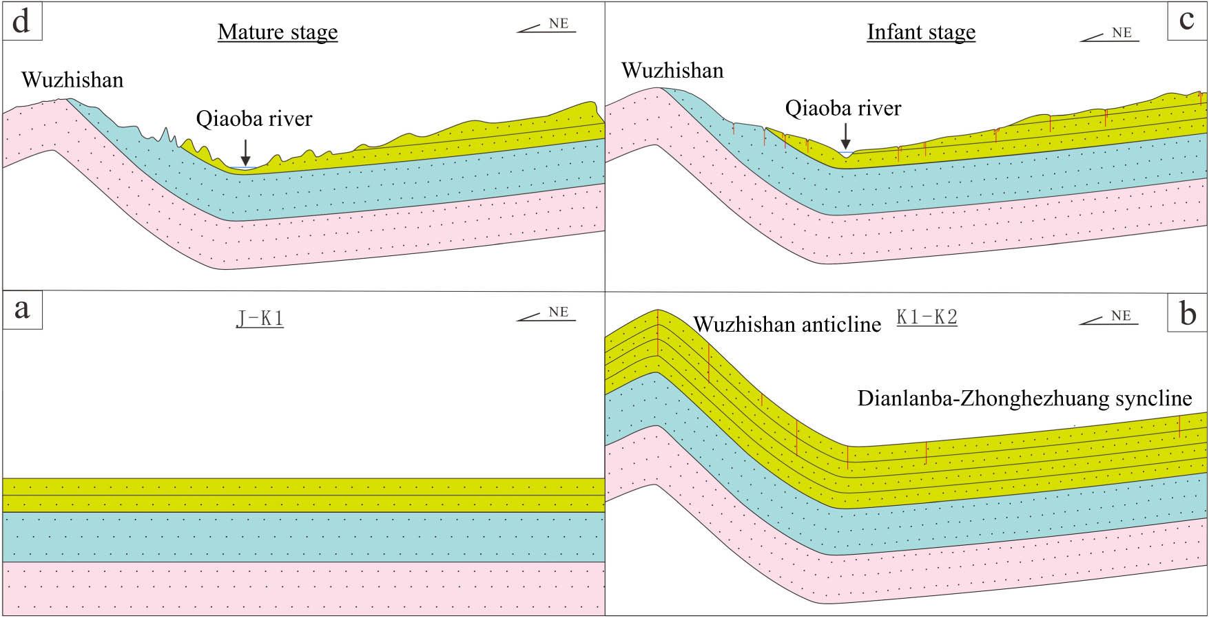
Evolution patterns for the formation process of Danxia landforms. (a) initial stage, (b) developmental stage, (c) Infant stage, and (d) Mature stage.
4.2.2 Formation of landforms
From formation of red-beds to development to the late mature stage, Danxia landforms in the research region of Qiaoba-Zhongdu Danxia landforms experienced the following processes: in the Cretaceous period, southwestern Sichuan Province was subjected to regional SSW-NNE compression while receiving red-bed sedimentation, gradually forming the NNW-SSE-trending Dianlanba-Zhonghezhuang syncline and Zhongdu fault. They laid the nearly V-shaped landform pattern on the vertical section. Then, southwestern Sichuan Province experienced regional NNW-SEE compression in the Himalayan period, so that the original NNW-SSE-trending Dianlanba-Zhonghezhuang syncline was superposed and transformed. The east section of the syncline turned to trend nearly along NW while the west section changed to a nearly NE-trending arc structure. Such an arc structure that is almost shown as a right-angle corner on the plane laid the overall landscape pattern of Qiaoba-Zhongdu Danxia landforms. Meanwhile, joints were developed in the region due to action of multi-directional stress (Figure 14b).
From 25 to 3 Ma, Mabian County in southern Sichuan Province was in a relatively stable period [59], when structures were stable and lots of natural meanders were developed in the research region of Qiaoba-Zhongdu Danxia landforms. From 3 Ma ago, the research region of Qiaoba-Zhongdu Danxia landforms entered a rapid uplifting stage, and red clastic rock construction being cut by vertical joints was uplifted above the base level of erosion. Under joint action of climate and external drivers, rocks in Danxia landforms were separated and collapsed along fault zones and joint planes. Water flow eroded and incised strata along the previously formed fractures and vertical joints, thus forming trenches and narrow gorges. As surface water further cut strata downward along trenches, walls of some narrow gorges collapsed along vertical joints. In this way, narrow gorges were further widened and deepened to form deeper lane-like valleys. After downward incision to a certain depth, water flows in the lane-like valleys laterally eroded the root of valley walls mainly through lateral erosion if encountering underlying hard strata or approaching local base level of erosion. As lateral erosion continued, vertical tensile fissures parallel to the slopes were likely to develop in the suspended valley walls in the upper part of lane-like valleys under the effect of gravity. After long-term weathering that widened and deepened the fissures, strata collapsed along vertical fissures, which further broadened lane-like valleys to form gorges. In the process, the original natural meanders formed meandering streams under control of tectonic activities. With tectonic uplifting, meandering streams further developed to incised meanders. In the period, water flows mainly incised strata downward, so lane-like valleys and gorges were developed. Meanwhile, large areas of top surfaces of deposits and weakly eroded platforms were retained in the upper part of red-beds, which belonged to the infant stage of Danxia landforms (Figure 14c).
With the formation of gorges and intensified collapse, colluvial deposits gradually accumulated on the bottom of gorges to develop unstable gentle slopes. Afterwards, because the base of scarp slopes was higher than the bottom of gorges, fluvial erosion was weakened or direct fluviation seldom occurred, while bed rocks at the cliff foot buried by colluvial deposits were temporarily protected. As the process continued, scarp slopes constantly collapsed and retreated, colluvial slopes became wider and higher to form gentle mountain feet. However, the originally gentle slope surfaces on the mountaintop continued to be cut, which gradually narrowed their areas and became peak clusters, peak forests, stone walls, and stone pillars. This can be exemplified by the stone pillar in Tianbao village and Huachaomen stone wall. Danxia landforms have entered the mature stage in the period (Figure 14d), in which human constantly adapted to and transformed the environment to finally form the current Danxia landforms.
5 Conclusion
The formation mechanisms of Danxia landforms were revealed from five aspects: the landscape-breeding effect of sedimentation, rendering effect of paleo-environmental conditions, landscaping effect of tectonism, carving effect of geomorphologic agents, and embellishing effect of human activities. Then, the formation process of Danxia landforms was clarified. The following conclusions are mainly obtained:
Qiaoba-Zhongdu Danxia landforms are exposed in areas of a large slope and topographic relief and mainly show concentrated distribution along fault zones and river systems. The HI value of areas is 0.43. It is discriminated by combining qualitative observation and quantitative calculation that the region is in the mature evolution stage of Danxia landforms. Danxia landforms in the research region of Qiaoba-Zhongdu Danxia landforms were developed in Cretaceous Wotoushan formation and mainly contained brick-red feldspar quartz sandstone interbedded with argillaceous fine siltstone and sandy mudstone. The research inferred that the lithological difference provided weathering condition for the development of Danxia landforms while sedimentary tectonic types enriched elements of Danxia landscapes.
Research on paleoclimate found that red-beds in the research region of Qiaoba-Zhongdu Danxia landforms were controlled by the climate. Wotoushan formation was formed in an arid and semi-arid freshwater sedimentary environment, in which the materials might source from Songpan-Ganzi region. Research on the tectonic evolution process of the research region of Qiaoba-Zhongdu Danxia landforms revealed that NNW-SSE-trending folds were formed in Dianlanba-Zhonghezhuang syncline under SSW-NNE stress compression in the Yanshanian period. Under NNW-SEE stress compression in Himalayan period, the east section of the syncline turned to be nearly NW-trending, so that the syncline was nearly V-shaped in NS vertical sections and shown as a right-angle corner on the plane. This laid the landscape pattern of Danxia landforms in the research region of Qiaoba-Zhongdu Danxia landforms.
Field survey of typical Danxia landscapes revealed that weathering, fluvial erosion, and collapse were main geomorphologic agents for formation of Danxia landforms in the research region of Qiaoba-Zhongdu Danxia landforms. The colorful ethnic culture, profound historical culture, and simple farming culture have been integrated with landforms and imparted rich features to Danxia landforms. The entire formation process of Danxia landforms involved five stages: landscape-breeding by sedimentation, rendering by paleo-environmental conditions, landscaping by tectonism, carving by geomorphologic agents, and embellishment by human activities.
-
Funding information: The authors acknowledge financial support provided by the National Natural Science Foundation of China (52074120), and the Fundamental Research Funds for the Central Universities (3142019005, 3142017107).
-
Author contributions: Qizhong Wang: Writing – original draft, Writing – review & editing. Ying Zhang & Zhiheng Cheng: Resources, Writing – review & editing, Funding acquisition. ShuYi Dong & Zhongquan Li: Conceptualization, Data curation, Investigation. Henglin Liu & Gen Li: Formal analysis.
-
Conflict of interest: The authors declare that they have no known competing financial interests or personal relationships that could have appeared to influence the work reported in this article.
References
[1] Berthling I, Etzelmuller B. The concept of cryo-conditioning in landscape evolution. Quat Res. 2011;75(2):378–84. 10.1016/j.yqres.2010.12.011.Search in Google Scholar
[2] Chen YX, Cui ZJ, Yang JQ. Influence of climate and tectonic movements on granite landforms in China. J Geogr Sci. 2009;19(5):587–99. 10.1007/s11442-009-0587-x.Search in Google Scholar
[3] Bingham RG, King EC, Smith AM, Pritchard HD. Glacial geomorphology: towards a convergence of glaciology and geomorphology. Prog Phys Geog. 2010;34(3):327–55. 10.1177/0309133309360631.Search in Google Scholar
[4] Phillips JD. Evolutionary creativity in landscapes. Earth Surf Processes Landforms. 2020;45(1):109–20. 10.1002/esp.4733.Search in Google Scholar
[5] Schuchova K, Lenart J. Geomorphology of old and abandoned underground mines: review and future challenges. Prog Phys Geog. 2020;44(6):791–813. 10.1177/0309133320917314.Search in Google Scholar
[6] Zou QL, Hou ZX, Liu T, Ma TF, Xu BC, Jiang CZ, et al. Influence of nanoparticle–surfactant compound solution on coal wettability. Energy Fuels. 2024;38(15):14064–71. 10.1021/acs.energyfuels.4c02101.Search in Google Scholar
[7] Ye CF, Xie HP, Wu F, Li CB. Nonlinear creep properties and time-to-failure prediction of sandstone under saturated and dry conditions. Environ Earth Sci. 2022;81:545. 10.1007/s12665-022-10666-5.Search in Google Scholar
[8] Zhao JJ, Tian SX, Jiang ZB, Li P, Li ZQ, Gou RT, et al. Study on the mechanism of SiO2–H2O nanofluid enhanced water injection in coal seam. Appl Surf Sci. 2024;658:159843. 10.1016/j.apsusc.2024.159843.Search in Google Scholar
[9] Zou QL, Chen ZH, Cheng ZH, Liang YP, Xu WJ, Wen PR, et al. Evaluation and intelligent deployment of coal and coalbed methane coupling coordinated exploitation based on Bayesian network and cuckoo search. Int J Min Sci Technol. 2022;32(6):1315–28. 10.1016/j.ijmst.2022.11.002.Search in Google Scholar
[10] Emmerton B, Burgess J, Esterle J, Erskine P, Baumgartl T. The application of natural landform analogy and geology-based spoil classification to improve surface stability of elevated spoil landforms in the Bowen Basin, Australia – A review. Land Degrad Dev. 2018;29(5):1489–508. 10.1002/ldr.2908.Search in Google Scholar
[11] Welivitiya WDDP, Hancock GR. Calibration and validation of the SSSPAM coupled soilscape-landform evolution model for simulating short-term gully development on a post-mining landform. Earth Surf Processes Landforms. 2022;47(11):2779–95. 10.1002/esp.5423.Search in Google Scholar
[12] Reed M, Kite S. Peripheral gully and landslide erosion on an extreme anthropogenic landscape produced by mountaintop removal coal mining. Earth Surf Processes Landforms. 2020;45(9):2078–90. 10.1002/esp.4867.Search in Google Scholar
[13] Kubalikova L, Kirchner K, Kuda F, Machar I. The role of anthropogenic landforms in sustainable landscape management. Sustainability. 2019;11(16):4331. 10.3390/su11164331.Search in Google Scholar
[14] Ran QC, Liang YP, Zou QL, Hong Y, Zhang BC, Liu H, et al. Experimental investigation on mechanical characteristics of red sandstone under graded cyclic loading and its inspirations for stability of overlying strata. Geomech Geophys Geo Energy Geo Resour. 2023;9(1):11. 10.1007/s40948-023-00555-x.Search in Google Scholar
[15] Zou QL, Chen ZH, Zhan JF, Chen CM, Gao SK, Kong FJ, et al. Morphological evolution and flow conduction characteristics of fracture channels in fractured sandstone under cyclic loading and unloading. Int J Min Sci Technol. 2023;33(12):1527–40. 10.1016/j.ijmst.2023.11.003.Search in Google Scholar
[16] Ran QC, Chen P, Liang YP, Ye CF, Zhang BC, Wu ZP, et al. Hardening-damage evolutionary mechanism of sandstone under multi-level cyclic loading. Eng Fract Mech. 2024;307:110291. 10.1016/j.engfracmech.2024.110291.Search in Google Scholar
[17] Chen ZH, Zou QL, Gao SK, Zhan JF, Chen CM, Ran QC, et al. Long-term evolution of overlying rock fractures in mined-out areas and its effect on gas flow conductivity. Fuel. 2023;353:129213. 10.1016/j.fuel.2023.129213.Search in Google Scholar
[18] Wei JQ, Su EL, Xu GW, Yang YQ, Han SR, Chen XJ, et al. Comparative analysis of permeability rebound and recovery of tectonic and intact coal: Implications for coalbed methane recovery in tectonic coal reservoirs. Energy. 2024;301:131702. 10.1016/j.energy.2024.131702.Search in Google Scholar
[19] Ma TF, Zou QL, Ran QC, Kong FJ. Compaction and re-crushing characteristics of sandstone granules with different gradations under cyclic loading. Int J Coal Sci Technol. 2024;35(9):104611. 10.1016/j.apt.2024.104611.Search in Google Scholar
[20] Ran QC, Liang YP, Zou QL, Zhang BC, Li RF, Chen ZH, et al. Characteristics of mining-induced fractures under inclined coal seam group multiple mining and implications for gas migration. Nat Resour Res. 2023;32(3):1481–501. 10.1007/s11053-023-10199-z.Search in Google Scholar
[21] Su EL, Wei JQ, Chen HD, Chen XJ, Liang YP, Zou QL, et al. Effect of CO2 injection on coalbed permeability based on a thermal-hydraulic-mechanical coupling model. Energy Fuels. 2024;38(12):11078–92. 10.1021/acs.energyfuels.4c01755.Search in Google Scholar
[22] Ye CF, Xie HP, Wu F, Li CB. Study on the nonlinear time-dependent deformation characteristics and viscoelastic-plastic model of shale under direct shear loading path. Bull Eng Geol Environ. 2023;82(5):189. 10.1007/s10064-023-03170-y.Search in Google Scholar
[23] Ma TF, Zou QL, Kong FJ, Ran QC, Qin DK, Hu YL, et al. Effect of loading rate on characteristics of cyclic structural adjustment of sandstone granules. Phys Fluids. 2024;36(9):097138. 10.1063/5.0218578.Search in Google Scholar
[24] Lowry JBC, Narayan M, Hancock GR, Evans KG. Understanding post-mining landforms: utilising pre-mine geomorphology to improve rehabilitation outcomes. Geomorphology. 2019;328:93–107. 10.1016/j.geomorph.2018.11.027.Search in Google Scholar
[25] Jancewicz K, Traczyk A, Migon P. Landform modifications within an intramontane urban landscape due to industrial activity, Walbrzych, SW Poland. J Maps. 2021;17(4):194–201. 10.1080/17445647.2020.1805805.Search in Google Scholar
[26] Wei H, Xiong LY, Zhao F, Tang GA, Lane SN. Large-scale spatial variability in loess landforms and their evolution, Luohe River Basin, Chinese Loess Plateau. Geomorphology. 2022;415:108407. 10.1016/j.geomorph.2022.108407.Search in Google Scholar
[27] Wu Y, Han ZX, Koko AF, Zhang SY. Spatio-temporal analysis of the driving factors of urban land use expansion in China: a study of the Yangtze River Delta region. Open Geosci. 2024;16(1):20220609. 10.1515/geo-2022-0609.Search in Google Scholar
[28] Li C, Qiao WF, Gao BP, Chen Y. Unveiling spatial heterogeneity of ecosystem services and their drivers in varied landform types: insights from the Sichuan-Yunnan ecological barrier area. J Clean Prod. 2024;442:141158. 10.1016/j.jclepro.2024.141158.Search in Google Scholar
[29] Li J, Ke XY, Wang XY, Wang L, Luo J, Feng SY. Analysis of soil organic carbon composition characteristics and causes in Wuming region Karst landforms, Nanning, Guangxi Province, China. Environ Earth Sci. 2024;83(11):349. 10.1007/s12665-024-11660-9.Search in Google Scholar
[30] Akintola GO. Geochemical evaluation of the carbonaceous shale associated with the Permian Mikambeni Formation of the Tuli Basin for potential gas generation, South Africa. Open Geosci. 2023;15(1):20220549. 10.1515/geo-2022-0549.Search in Google Scholar
[31] Peng H, Pan ZX, Yan LB, Scott S. A review of the research on red beds and Danxia landform. Acta Geographica Sin. 2013;68(9):1170–81.Search in Google Scholar
[32] Straahler AN. Hypsometric (Area-Altitude) analysis of erosional topography. Bull Geol Soc Am. 1952;63:1117–42.10.1130/0016-7606(1952)63[1117:HAAOET]2.0.CO;2Search in Google Scholar
[33] Pike RJ, Wilson S. Elevation-relief ratio, hypsometric integral, and geomorphic area-altitude analysis. Geol Soc Am Bull. 1971;82:1079–84.10.1130/0016-7606(1971)82[1079:ERHIAG]2.0.CO;2Search in Google Scholar
[34] Zeng YF, Tan JX. Sedimentology development status and prospects. J Chengdu Univ Technol. 1999;1:4–10.Search in Google Scholar
[35] Zhu C, Yu JB, Zhao NX, Li G, Wu CZ. Danxia landform genesis and scenic feature on Guanzai mountain, Fujian Province. Acta Geographica Sin. 2000;6:679–88.Search in Google Scholar
[36] Strahler AN. Dynamic basis of geomorphology. Geol Soc Am Bull. 1952;63(9):923. 10.1130/0016-7606(1952)63[923:Dbog]2.0.Co;2.Search in Google Scholar
[37] Shi ZS, Chen KY, He HJ, Shi J, Liu BJ, Liu G. Application of Sr isotope to sedimentary environment analysis. Oil Gas Geol. 2003;2:187–90.Search in Google Scholar
[38] Li HK, Li ZQ, Long W, Wan SS, Ding X, Wang SZ, Wang QZ. Vertical configuration of Sichuan Basin and its superimposed characteristics of the prototype basin. J Chengdu Univ Technol. 2019;46(3):257–67.Search in Google Scholar
[39] Tribovillard N, Algeo TJ, Lyons T, Riboulleau A. Trace metals as paleoredox and paleoproductivity proxies: an update. Chem Geol. 2000;232(1–2):12–32.10.1016/j.chemgeo.2006.02.012Search in Google Scholar
[40] Jones B, Manning DAC. Comparison of geochemical indices used for the interpretation of palaeoredox conditions in ancient mudstones. Chem Geol. 1994;111:111–29.10.1016/0009-2541(94)90085-XSearch in Google Scholar
[41] Chen HX, Zhao B, Chen LK. Palaeontology characteristics and sedimentary environment of the upper triassic Xujiahe Formation in the Pujiang area, Sichuan, China. Geol Bull China. 2009;28(4):493–500.Search in Google Scholar
[42] Suttner LJ, Dutta PK. Alluvial sandstone composition and paleoclimate; 1, framework mineralogy. J Sediment Pet. 1986;56(3):329–45.10.1306/212F8909-2B24-11D7-8648000102C1865DSearch in Google Scholar
[43] Zhang TF, Sun LX, Zhang Y, Cheng YH, Li YF, Ma HL, et al. Geochemical chareceristics of the Jurassic Yanan and Zhiluo formations in the northern margin of Ordos basin and their paleoenvironmental implications. Acta Geol Sin. 2016;90(12):3454–72.Search in Google Scholar
[44] Long XP, Yuan C, Sun M, Xiao WJ, Wang YJ, Cai KD, et al. Geochemistry and Nd isotopic composition of the early paleozoic flysch sequence in the Chinese Altai, Central Asia: evidence for a northward-derived mafic source and insight into Nd model ages in accretionary orogen. Gondwana Res. 2012;22(2):554–66. 10.1016/j.gr.2011.04.009.Search in Google Scholar
[45] Mclennan SM. Weathering and global denudation. J Geol. 1993;101(2):295–303. 10.1086/648222.Search in Google Scholar
[46] Floyd PA, Winchester JA, Park RG. Geochemistry and tectonic setting of Lewisian clastic metasediments from the Early Proterozoic Loch Maree Group of Gairloch, Nw Scotland. Precambrian Res. 1989;45(1-3):203–14. 10.1016/0301-9268(89)90040-5.Search in Google Scholar
[47] Floyd PA, Leveridge BE. Tectonic environment of the Devonian Gramscatho basin, south Cornwall – framework mode and geochemical evidence from turbiditic sandstones. J Geol Soc Lond. 1987;144:531–42. 10.1144/gsjgs.144.4.0531.Search in Google Scholar
[48] Bhatia MR. Rare-earth element geochemistry of Australian paleozoic graywackes and mudrocks – provenance and tectonic control. Sediment Geol. 1985;45(1–2):97–113. 10.1016/0037-0738(85)90025-9.Search in Google Scholar
[49] Su BX, Chen YL, Liu F, Wang QY, Zhang HF, Lan ZW. Geochemical characteristics and significance of Triassic sandstones of Songpan-Ganze block. Acta Petrol Sin. 2006;22(4):961–70.Search in Google Scholar
[50] Luo ZL, Long XM. The uplifting of the Longmenshan orogenic zone and the subsidence of the West Sichuan foreland basin. Acta Geol Sichuan. 1992;1:1–17.Search in Google Scholar
[51] Li Y, Su DC, Dong SL, Yan ZK, He P, Yan L. The recognition of the basal unconformity in the Longmenshan foreland basin: transition from passive continent margin to foreland basin. Acta Petrol Sin. 2011;27(8):2413–22.Search in Google Scholar
[52] Yan DP, Zhou MF, Song HL, Wang XW, Malpas J. Origin and tectonic significance of a Mesozoic multi-layer over-thrust system within the Yangtze Block (South China). Tectonophysics. 2003;361(3–4):239–54. 10.1016/S0040-1951(02)00646-7.Search in Google Scholar
[53] Yan DP, Zhang B, Zhou MF, Wei GQ, Song HL, Liu SF. Constraints on the depth, geometry and kinematics of blind detachment faults provided by fault-propagation folds: an example from the Mesozoic fold belt of South China. J Struct Geol. 2009;31(2):150–62. 10.1016/j.jsg.2008.11.005.Search in Google Scholar
[54] Faure M, Lepvrier C, Nguyen VV, Vu TV, Lin W, Chen ZC. The South China block-Indochina collision: where, when, and how? J Asian Earth Sci. 2014;79:260–74. 10.1016/j.jseaes.2013.09.022.Search in Google Scholar
[55] Guo FS, Ling YY, Chen LQ, Zhou WP, Li HW, Cheng LK, et al. Controlling factors and types of geomorphologic landscapes in Danxiashan UNESCO global Geopark of China. Geoscience. 2023;37(6):1665–79. 10.19657/j.geoscience.1000-8527.2023.099.Search in Google Scholar
[56] Chen LQ, Guo FS, Liu FJ, Xu H, Ding T, Liu X. Origin of Tafoni in the Late Cretaceous Aeolian Sandstones, Danxiashan UNESCO Global Geopark, South China. Acta Geol Sin-Engl. 2019;93(2):451–63. 10.1111/1755-6724.13810.Search in Google Scholar
[57] Gao L. Diagenesis of carbonate rocks and their control over reservoirs – an example from the Puguang gas field. Oil & Gas Geol. 2008;29(6):733–9+47.Search in Google Scholar
[58] Wang YB, Li ZW, Deng B, Liu SG, Zhao GP, Lin T, et al. Pop-up structure in fold-and-thrust belt and its lmplications: an insight from analogue sandbox models of thrust wedge. Geoscience. 2016;30(1):110–21.Search in Google Scholar
[59] An YF, Han ZJ, Wan JL. Fission track dating of the Cenozoic uplift in Mabian area, southern Sichuan Province, China. Sci China(Series D:Earth Sci). 2008;38(5):555–63.Search in Google Scholar
© 2024 the author(s), published by De Gruyter
This work is licensed under the Creative Commons Attribution 4.0 International License.
Articles in the same Issue
- Regular Articles
- Theoretical magnetotelluric response of stratiform earth consisting of alternative homogeneous and transitional layers
- The research of common drought indexes for the application to the drought monitoring in the region of Jin Sha river
- Evolutionary game analysis of government, businesses, and consumers in high-standard farmland low-carbon construction
- On the use of low-frequency passive seismic as a direct hydrocarbon indicator: A case study at Banyubang oil field, Indonesia
- Water transportation planning in connection with extreme weather conditions; case study – Port of Novi Sad, Serbia
- Zircon U–Pb ages of the Paleozoic volcaniclastic strata in the Junggar Basin, NW China
- Monitoring of mangrove forests vegetation based on optical versus microwave data: A case study western coast of Saudi Arabia
- Microfacies analysis of marine shale: A case study of the shales of the Wufeng–Longmaxi formation in the western Chongqing, Sichuan Basin, China
- Multisource remote sensing image fusion processing in plateau seismic region feature information extraction and application analysis – An example of the Menyuan Ms6.9 earthquake on January 8, 2022
- Identification of magnetic mineralogy and paleo-flow direction of the Miocene-quaternary volcanic products in the north of Lake Van, Eastern Turkey
- Impact of fully rotating steel casing bored pile on adjacent tunnels
- Adolescents’ consumption intentions toward leisure tourism in high-risk leisure environments in riverine areas
- Petrogenesis of Jurassic granitic rocks in South China Block: Implications for events related to subduction of Paleo-Pacific plate
- Differences in urban daytime and night block vitality based on mobile phone signaling data: A case study of Kunming’s urban district
- Random forest and artificial neural network-based tsunami forests classification using data fusion of Sentinel-2 and Airbus Vision-1 satellites: A case study of Garhi Chandan, Pakistan
- Integrated geophysical approach for detection and size-geometry characterization of a multiscale karst system in carbonate units, semiarid Brazil
- Spatial and temporal changes in ecosystem services value and analysis of driving factors in the Yangtze River Delta Region
- Deep fault sliding rates for Ka-Ping block of Xinjiang based on repeating earthquakes
- Improved deep learning segmentation of outdoor point clouds with different sampling strategies and using intensities
- Platform margin belt structure and sedimentation characteristics of Changxing Formation reefs on both sides of the Kaijiang-Liangping trough, eastern Sichuan Basin, China
- Enhancing attapulgite and cement-modified loess for effective landfill lining: A study on seepage prevention and Cu/Pb ion adsorption
- Flood risk assessment, a case study in an arid environment of Southeast Morocco
- Lower limits of physical properties and classification evaluation criteria of the tight reservoir in the Ahe Formation in the Dibei Area of the Kuqa depression
- Evaluation of Viaducts’ contribution to road network accessibility in the Yunnan–Guizhou area based on the node deletion method
- Permian tectonic switch of the southern Central Asian Orogenic Belt: Constraints from magmatism in the southern Alxa region, NW China
- Element geochemical differences in lower Cambrian black shales with hydrothermal sedimentation in the Yangtze block, South China
- Three-dimensional finite-memory quasi-Newton inversion of the magnetotelluric based on unstructured grids
- Obliquity-paced summer monsoon from the Shilou red clay section on the eastern Chinese Loess Plateau
- Classification and logging identification of reservoir space near the upper Ordovician pinch-out line in Tahe Oilfield
- Ultra-deep channel sand body target recognition method based on improved deep learning under UAV cluster
- New formula to determine flyrock distance on sedimentary rocks with low strength
- Assessing the ecological security of tourism in Northeast China
- Effective reservoir identification and sweet spot prediction in Chang 8 Member tight oil reservoirs in Huanjiang area, Ordos Basin
- Detecting heterogeneity of spatial accessibility to sports facilities for adolescents at fine scale: A case study in Changsha, China
- Effects of freeze–thaw cycles on soil nutrients by soft rock and sand remodeling
- Vibration prediction with a method based on the absorption property of blast-induced seismic waves: A case study
- A new look at the geodynamic development of the Ediacaran–early Cambrian forearc basalts of the Tannuola-Khamsara Island Arc (Central Asia, Russia): Conclusions from geological, geochemical, and Nd-isotope data
- Spatio-temporal analysis of the driving factors of urban land use expansion in China: A study of the Yangtze River Delta region
- Selection of Euler deconvolution solutions using the enhanced horizontal gradient and stable vertical differentiation
- Phase change of the Ordovician hydrocarbon in the Tarim Basin: A case study from the Halahatang–Shunbei area
- Using interpretative structure model and analytical network process for optimum site selection of airport locations in Delta Egypt
- Geochemistry of magnetite from Fe-skarn deposits along the central Loei Fold Belt, Thailand
- Functional typology of settlements in the Srem region, Serbia
- Hunger Games Search for the elucidation of gravity anomalies with application to geothermal energy investigations and volcanic activity studies
- Addressing incomplete tile phenomena in image tiling: Introducing the grid six-intersection model
- Evaluation and control model for resilience of water resource building system based on fuzzy comprehensive evaluation method and its application
- MIF and AHP methods for delineation of groundwater potential zones using remote sensing and GIS techniques in Tirunelveli, Tenkasi District, India
- New database for the estimation of dynamic coefficient of friction of snow
- Measuring urban growth dynamics: A study in Hue city, Vietnam
- Comparative models of support-vector machine, multilayer perceptron, and decision tree predication approaches for landslide susceptibility analysis
- Experimental study on the influence of clay content on the shear strength of silty soil and mechanism analysis
- Geosite assessment as a contribution to the sustainable development of Babušnica, Serbia
- Using fuzzy analytical hierarchy process for road transportation services management based on remote sensing and GIS technology
- Accumulation mechanism of multi-type unconventional oil and gas reservoirs in Northern China: Taking Hari Sag of the Yin’e Basin as an example
- TOC prediction of source rocks based on the convolutional neural network and logging curves – A case study of Pinghu Formation in Xihu Sag
- A method for fast detection of wind farms from remote sensing images using deep learning and geospatial analysis
- Spatial distribution and driving factors of karst rocky desertification in Southwest China based on GIS and geodetector
- Physicochemical and mineralogical composition studies of clays from Share and Tshonga areas, Northern Bida Basin, Nigeria: Implications for Geophagia
- Geochemical sedimentary records of eutrophication and environmental change in Chaohu Lake, East China
- Research progress of freeze–thaw rock using bibliometric analysis
- Mixed irrigation affects the composition and diversity of the soil bacterial community
- Examining the swelling potential of cohesive soils with high plasticity according to their index properties using GIS
- Geological genesis and identification of high-porosity and low-permeability sandstones in the Cretaceous Bashkirchik Formation, northern Tarim Basin
- Usability of PPGIS tools exemplified by geodiscussion – a tool for public participation in shaping public space
- Efficient development technology of Upper Paleozoic Lower Shihezi tight sandstone gas reservoir in northeastern Ordos Basin
- Assessment of soil resources of agricultural landscapes in Turkestan region of the Republic of Kazakhstan based on agrochemical indexes
- Evaluating the impact of DEM interpolation algorithms on relief index for soil resource management
- Petrogenetic relationship between plutonic and subvolcanic rocks in the Jurassic Shuikoushan complex, South China
- A novel workflow for shale lithology identification – A case study in the Gulong Depression, Songliao Basin, China
- Characteristics and main controlling factors of dolomite reservoirs in Fei-3 Member of Feixianguan Formation of Lower Triassic, Puguang area
- Impact of high-speed railway network on county-level accessibility and economic linkage in Jiangxi Province, China: A spatio-temporal data analysis
- Estimation model of wild fractional vegetation cover based on RGB vegetation index and its application
- Lithofacies, petrography, and geochemistry of the Lamphun oceanic plate stratigraphy: As a record of the subduction history of Paleo-Tethys in Chiang Mai-Chiang Rai Suture Zone of Thailand
- Structural features and tectonic activity of the Weihe Fault, central China
- Application of the wavelet transform and Hilbert–Huang transform in stratigraphic sequence division of Jurassic Shaximiao Formation in Southwest Sichuan Basin
- Structural detachment influences the shale gas preservation in the Wufeng-Longmaxi Formation, Northern Guizhou Province
- Distribution law of Chang 7 Member tight oil in the western Ordos Basin based on geological, logging and numerical simulation techniques
- Evaluation of alteration in the geothermal province west of Cappadocia, Türkiye: Mineralogical, petrographical, geochemical, and remote sensing data
- Numerical modeling of site response at large strains with simplified nonlinear models: Application to Lotung seismic array
- Quantitative characterization of granite failure intensity under dynamic disturbance from energy standpoint
- Characteristics of debris flow dynamics and prediction of the hazardous area in Bangou Village, Yanqing District, Beijing, China
- Rockfall mapping and susceptibility evaluation based on UAV high-resolution imagery and support vector machine method
- Statistical comparison analysis of different real-time kinematic methods for the development of photogrammetric products: CORS-RTK, CORS-RTK + PPK, RTK-DRTK2, and RTK + DRTK2 + GCP
- Hydrogeological mapping of fracture networks using earth observation data to improve rainfall–runoff modeling in arid mountains, Saudi Arabia
- Petrography and geochemistry of pegmatite and leucogranite of Ntega-Marangara area, Burundi, in relation to rare metal mineralisation
- Prediction of formation fracture pressure based on reinforcement learning and XGBoost
- Hazard zonation for potential earthquake-induced landslide in the eastern East Kunlun fault zone
- Monitoring water infiltration in multiple layers of sandstone coal mining model with cracks using ERT
- Study of the patterns of ice lake variation and the factors influencing these changes in the western Nyingchi area
- Productive conservation at the landslide prone area under the threat of rapid land cover changes
- Sedimentary processes and patterns in deposits corresponding to freshwater lake-facies of hyperpycnal flow – An experimental study based on flume depositional simulations
- Study on time-dependent injectability evaluation of mudstone considering the self-healing effect
- Detection of objects with diverse geometric shapes in GPR images using deep-learning methods
- Behavior of trace metals in sedimentary cores from marine and lacustrine environments in Algeria
- Spatiotemporal variation pattern and spatial coupling relationship between NDVI and LST in Mu Us Sandy Land
- Formation mechanism and oil-bearing properties of gravity flow sand body of Chang 63 sub-member of Yanchang Formation in Huaqing area, Ordos Basin
- Diagenesis of marine-continental transitional shale from the Upper Permian Longtan Formation in southern Sichuan Basin, China
- Vertical high-velocity structures and seismic activity in western Shandong Rise, China: Case study inspired by double-difference seismic tomography
- Spatial coupling relationship between metamorphic core complex and gold deposits: Constraints from geophysical electromagnetics
- Disparities in the geospatial allocation of public facilities from the perspective of living circles
- Research on spatial correlation structure of war heritage based on field theory. A case study of Jinzhai County, China
- Formation mechanisms of Qiaoba-Zhongdu Danxia landforms in southwestern Sichuan Province, China
- Magnetic data interpretation: Implication for structure and hydrocarbon potentiality at Delta Wadi Diit, Southeastern Egypt
- Deeply buried clastic rock diagenesis evolution mechanism of Dongdaohaizi sag in the center of Junggar fault basin, Northwest China
- Application of LS-RAPID to simulate the motion of two contrasting landslides triggered by earthquakes
- The new insight of tectonic setting in Sunda–Banda transition zone using tomography seismic. Case study: 7.1 M deep earthquake 29 August 2023
- The critical role of c and φ in ensuring stability: A study on rockfill dams
- Evidence of late quaternary activity of the Weining-Shuicheng Fault in Guizhou, China
- Extreme hydroclimatic events and response of vegetation in the eastern QTP since 10 ka
- Spatial–temporal effect of sea–land gradient on landscape pattern and ecological risk in the coastal zone: A case study of Dalian City
- Study on the influence mechanism of land use on carbon storage under multiple scenarios: A case study of Wenzhou
- A new method for identifying reservoir fluid properties based on well logging data: A case study from PL block of Bohai Bay Basin, North China
- Comparison between thermal models across the Middle Magdalena Valley, Eastern Cordillera, and Eastern Llanos basins in Colombia
- Mineralogical and elemental analysis of Kazakh coals from three mines: Preliminary insights from mode of occurrence to environmental impacts
- Chlorite-induced porosity evolution in multi-source tight sandstone reservoirs: A case study of the Shaximiao Formation in western Sichuan Basin
- Predicting stability factors for rotational failures in earth slopes and embankments using artificial intelligence techniques
- Origin of Late Cretaceous A-type granitoids in South China: Response to the rollback and retreat of the Paleo-Pacific plate
- Modification of dolomitization on reservoir spaces in reef–shoal complex: A case study of Permian Changxing Formation, Sichuan Basin, SW China
- Geological characteristics of the Daduhe gold belt, western Sichuan, China: Implications for exploration
- Rock physics model for deep coal-bed methane reservoir based on equivalent medium theory: A case study of Carboniferous-Permian in Eastern Ordos Basin
- Enhancing the total-field magnetic anomaly using the normalized source strength
- Shear wave velocity profiling of Riyadh City, Saudi Arabia, utilizing the multi-channel analysis of surface waves method
- Effect of coal facies on pore structure heterogeneity of coal measures: Quantitative characterization and comparative study
- Inversion method of organic matter content of different types of soils in black soil area based on hyperspectral indices
- Detection of seepage zones in artificial levees: A case study at the Körös River, Hungary
- Tight sandstone fluid detection technology based on multi-wave seismic data
- Characteristics and control techniques of soft rock tunnel lining cracks in high geo-stress environments: Case study of Wushaoling tunnel group
- Influence of pore structure characteristics on the Permian Shan-1 reservoir in Longdong, Southwest Ordos Basin, China
- Study on sedimentary model of Shanxi Formation – Lower Shihezi Formation in Da 17 well area of Daniudi gas field, Ordos Basin
- Multi-scenario territorial spatial simulation and dynamic changes: A case study of Jilin Province in China from 1985 to 2030
- Review Articles
- Major ascidian species with negative impacts on bivalve aquaculture: Current knowledge and future research aims
- Prediction and assessment of meteorological drought in southwest China using long short-term memory model
- Communication
- Essential questions in earth and geosciences according to large language models
- Erratum
- Erratum to “Random forest and artificial neural network-based tsunami forests classification using data fusion of Sentinel-2 and Airbus Vision-1 satellites: A case study of Garhi Chandan, Pakistan”
- Special Issue: Natural Resources and Environmental Risks: Towards a Sustainable Future - Part I
- Spatial-temporal and trend analysis of traffic accidents in AP Vojvodina (North Serbia)
- Exploring environmental awareness, knowledge, and safety: A comparative study among students in Montenegro and North Macedonia
- Determinants influencing tourists’ willingness to visit Türkiye – Impact of earthquake hazards on Serbian visitors’ preferences
- Application of remote sensing in monitoring land degradation: A case study of Stanari municipality (Bosnia and Herzegovina)
- Optimizing agricultural land use: A GIS-based assessment of suitability in the Sana River Basin, Bosnia and Herzegovina
- Assessing risk-prone areas in the Kratovska Reka catchment (North Macedonia) by integrating advanced geospatial analytics and flash flood potential index
- Analysis of the intensity of erosive processes and state of vegetation cover in the zone of influence of the Kolubara Mining Basin
- GIS-based spatial modeling of landslide susceptibility using BWM-LSI: A case study – city of Smederevo (Serbia)
- Geospatial modeling of wildfire susceptibility on a national scale in Montenegro: A comparative evaluation of F-AHP and FR methodologies
- Geosite assessment as the first step for the development of canyoning activities in North Montenegro
- Urban geoheritage and degradation risk assessment of the Sokograd fortress (Sokobanja, Eastern Serbia)
- Multi-hazard modeling of erosion and landslide susceptibility at the national scale in the example of North Macedonia
- Understanding seismic hazard resilience in Montenegro: A qualitative analysis of community preparedness and response capabilities
- Forest soil CO2 emission in Quercus robur level II monitoring site
- Characterization of glomalin proteins in soil: A potential indicator of erosion intensity
- Power of Terroir: Case study of Grašac at the Fruška Gora wine region (North Serbia)
- Special Issue: Geospatial and Environmental Dynamics - Part I
- Qualitative insights into cultural heritage protection in Serbia: Addressing legal and institutional gaps for disaster risk resilience