Deeply buried clastic rock diagenesis evolution mechanism of Dongdaohaizi sag in the center of Junggar fault basin, Northwest China
-
Shasha Guo


Abstract
To reveal the diagenetic sequence of reservoir rocks in the central part of the deep depression basin, the Wuerhe Formation in Junggar Basin was taken as an example to conduct the detailed studies on its sedimentary facies, diagenetic sequence, and the micropore structure evolution rules based on the comprehensive data from a super deep exploration well C-6 (approximately 7,000 m in depth). First, an arid environment fan delta sedimentary model of the Wuerhe Formation was established, and its sedimentary evolution law was clarified as a gradual transition from a fan delta front to a fan delta plain during the water-regression process until the lake dried up. Then, the diagenesis types and evolution sequence of the Wuerhe Formation, and the influence degrees of the compaction, cementation, and dissolution on the rock formation process were clarified. Finally, the diagenesis and pore evolution model was established, and the greatest impact factors of the late reservoir densification were clarified. Based on this research, the diagenesis and pore evolution processes of the deep rocks in the studied deep central sag were ultimately revealed to provide useful guidance for the deeply buried oil and gas reservoir exploration.
1 Introduction
Generally, the central area of a large depression basin is far from the source area and is composed mainly of fine-grained sedimentary rocks that formed in a deep-water environment [1,2]. Due to the abundance of organic matter in such rocks, these areas are usually considered the main locations for hydrocarbon generation but lack high-quality oil and gas reservoirs [3,4]. In contrast, the sediments that fill the deep sags of large, faulted basins do not come from the basin edges but rather from nearby secondary uplifts. Even if these sediments are located in the center of a basin and are buried deeply, the rock types here can still include very coarse-grained sandstones and conglomerates. However, whether these rocks can maintain good porosity and permeability and become favorable areas for hydrocarbon accumulation and storage depends on the sedimentary processes and diagenesis they experience later on [5,6]. Due to the independence and small scale of different secondary uplifts in large, faulted basins, the sedimentary facies types in the early filling stage are very complex, making it difficult to establish a unified sedimentary model that can characterize the entire basin [7,8,9]. Scholars generally agree on the genesis of conglomerate and coarse sandstone in depressions; such rock types can be attributed to near-source alluvial fans and fan deltas [10,11]. However, there is often heated debate about the genesis of thick mudstones in these areas. Two main viewpoints exist: the deep-water theory suggests that widespread mudstone is related to the rise of a lake surface, and the drought theory proposes that mudstone is formed by the sedimentation of river fans that eventually disappear under arid environmental conditions [12,13,14,15]. The mudstone type is closely related to the sedimentary environment and can indicate the scale of sedimentary bodies and the sandstone quality; these factors ultimately determine whether an area has the potential for oil and gas generation and accumulation [16,17,18]. Therefore, it is crucial to understand the sedimentary environment and facies types in deep depression areas and establish a unified sedimentary model to accurately assess the potential for hydrocarbon resource exploitation in these areas [19,20].
A lot of research on the diagenesis of sandstone in deep sag areas shows that in the center of a deep fault basin, due to the relatively large thickness of sedimentary rocks above it, compaction is intense. As a result of this compaction, the preservation of primary porosity in these sandstones is low, and they are typically characterized as low-permeability or tight sandstones. If no subsequent diagenesis occurs to affect their structures and mineral composition, the porosity and permeability of these sandstones will remain low, and they may not form good hydrocarbon reservoirs [21,22,23]. Similar to sedimentary facies, diagenesis is another vital factor affecting the reservoir quality. Research has confirmed that under strong compaction conditions, some plastic particles, such as mica and mudstone fragments, can become deformed and block the connecting throats within rock [24,25,26]. In contrast, rigid particles such as quartz and feldspar are difficult to compress but can be broken under strong compaction, leading to the accumulation of small fragments in the pores and ultimately reducing the porosity size [27,28,29]. Relevant research has shown that pore expansion can occur during strong compaction. This is because fluids flowing under pressure can react with the rock skeleton, dissolving existing minerals and creating pores or channels in the rock. This process is an effective way for oil and gas reservoirs to form in deep sandstones [30,31]. However, cementation and dissolution interact during the fluid flow process, and some dissolved substances can also precipitate and form cements, leading to a porosity decrease [32,33,34]. Under strong compaction and weak dissolution, sandstone pores in deep areas can still be effectively preserved, and one important condition favorable for this process is the formation of overpressure [35]. During a flood period in areas such as alluvial fans and fan deltas, a significant amount of sediment can accumulate rapidly, potentially leading to the formation of overpressure. This overpressure can inhibit any further compaction increase and slow the cementation degree; these changes are conducive to retaining pores [36]. Although central depression areas are located far from the source area and have difficulty forming rapidly accumulating strata, the organic matter contents of mudstones for hydrocarbon generation in such areas are very high and can rapidly transform to hydrocarbons under high-temperature and high-pressure conditions [37,38]. The expansion of hydrocarbons can increase the pressure within the surrounding formation, leading to the formation of overpressure. Under these conditions, the high pressure within the formation facilitates the migration of oil and gas to high-porosity and high-permeability adjacent reservoirs. Many secondary pore zones and oil and gas reservoirs have been found in the deep Junggar Basin, proving that this view is correct; i.e., in areas with large burial depths, overpressure is crucial for preserving and regenerating pores [39,40,41,42]. Therefore, it is very beneficial to search for valuable oil and gas reservoirs to determine the diagenesis process and pore evolution law of the deep, buried rocks in the center of the basin.
The Junggar Basin is a large basin formed by the superposition of multiple tectonic unit belts of different levels. This basin has the characteristics of a typical faulted basin, including six first-order tectonic units and 44 secondary tectonic units [43,44,45,46]. In the early stages of exploration, the deep depressions in the center of the Junggar Basin were overlooked. However, recently, several oil and gas fields have been discovered around the central region, and the oil source has been confirmed to be the deep Permian source rocks. This finding indicates that the material conditions necessary for forming oil reservoirs are present [47,48]. In October 2020, a significant well, C-6, was drilled in the center of the basin to a drilling depth of 6,950 m, thus allowing much information about ultradeep sedimentary rock to be obtained. Data analyses of this well have confirmed that porous rocks remain at depths reaching 7,000 m with the potential to form oil and gas reservoirs. From this perspective, initially, abandoned areas are not necessarily worthless but may actually contain significant potential. In this article, the rare ultradeep drilling data from the C-6 well, a typical drilled well, were used to examine the petrogenesis and diagenesis processes of the deep depression area in the Junggar Basin. This work clarifies the characteristics and evolution laws of reservoir pores and defines the control factors impacting the reservoir quality. This research approach and method have high applicability and can offer guidance for the exploration of oil and gas resources in the central depression areas of similar basins.
2 Methods and data
2.1 Research method and process
The purpose of this article is to understand the diagenetic evolution mechanism of the deep rocks in the central depression of the Junggar Basin and obtain the factors controlling the reservoir porosity, permeability, and other physical parameters. Therefore, according to geological, logging, and other data, this study first analyzes the structure, sequence, and sedimentary background of the Wuerhe Formation and determines the sedimentary facies model. Then, the physical properties of the reservoir rocks are studied. The pore, throat type, origin, and pore structure characteristic parameters of various reservoirs are studied. The pore evolution mechanism is analyzed, and the physical properties of the clastic rock reservoirs are summarized. Finally, we study the diagenetic evolution of the reservoir rocks, analyze the diagenesis process, divide the diagenetic sequences, and analyze the diagenetic evolution history. On this basis, this study analyzes the impact of diagenesis on the physical properties of the clastic rock reservoirs, summarizes the impacts of different diagenesis processes and stages on the reservoirs’ physical properties with the diagenetic evolution history, determines the factors controlling the high-quality reservoirs in the studied basin, and predicts the distribution rules of the identified reservoirs (Figure 1).

Research process.
2.2 Source of experimental data
To obtain research results with dependable conclusions, several rock analysis experimental methods are used. These experiments include casting thin-section observations, a rock particle size analysis, scanning electron microscope (SEM) rock observations, physical property testing, and nuclear magnetic resonance (NMR) testing. By developing these experiments, considerable true and reliable data are obtained, allowing the research to be conducted smoothly. The rock samples used in the experiment are from well C-6; this well has the deepest drilling depth among all wells drilled in the center of the depression. It is the only well that encountered the Wuerhe Formation in the center of the basin (with a drilling depth of 6,950 m). The sampling depth ranged from 6,400 to 6,950 m, and a total of 9 rock samples were obtained, including 3 silty mudstone, 4 argillaceous siltstone, and 2 siltstone samples Table 1.
Summary of experimental data
| Well | Sample number | Depth (m) | Type of experiment | ||||
|---|---|---|---|---|---|---|---|
| Scanning electron microscope | Casting thin section | Grain size analysis | Nuclear magnetic resonance | Physical property analysis | |||
| CH-6 | MC-12 | 5,452 | Yes | Yes | Yes | Yes | Yes |
| CH-6 | MC-17 | 5,470 | Yes | Yes | Yes | No | No |
| CH-6 | MC-18 | 5,490 | Yes | Yes | No | Yes | No |
| CH-6 | MC-22 | 6,224 | Yes | Yes | Yes | No | Yes |
| CH-6 | MC-23 | 6,528 | Yes | Yes | Yes | Yes | Yes |
| CH-6 | MC-24 | 6,530 | Yes | Yes | No | No | No |
| CH-6 | MC-26 | 6,613 | Yes | Yes | No | Yes | No |
3 Background of the study area
The Junggar Basin is in the eastern Kazakhstan Junggar plate, adjacent to the Siberian plate in the north, the Tarim plate in the south, the northern Tianshan orogen, and the Bogda tectonic, West Junggar orogenic, and Kelamei orogenic belts in the south, west, and north, respectively [49,50]. The basin is rich in oil and gas resources and is a vital closed basin in western China (Figure 2). The Permian Wuerhe Formation’s strata in the Dongdaohaizi sag tend southwestward, and the sedimentary thickness decreases from southwest to northeast, with a maximum burial depth of approximately 7,500 m.

Regional structure location map.
3.1 Evolution of sedimentary environment and characteristics
The Wuerhe Formation is located at the bottom of the sag sedimentary stratum, representing the initial stage of the fault depression formation. The slope is steep, and the vertical drop is large. The mudstone color in this period can directly reflect the sedimentary environment at the time of deposition. The mudstone of the Lower Wuerhe Formation is dark gray and gray, reflecting a strong reducing environment and indicating that the water was deep at this time and that the sediments were deposited along the shore of a shallow to semideep lake. In the next period, most sags were located in lacustrine sedimentary environments. During the deposition of the second-lowest segment, the fan body further expanded, and a set of fan delta front and plain sediments were deposited [51,52].
From the upper Wuerhe Formation, the mudstone becomes lighter until it becomes brownish red and red mudstone, reflecting a strong oxidation environment and indicating that the depositional environment was a continental sedimentary environment at that time. In a dry climate stage, the water body shrunk, the fan scale shrunk, and the sedimentary scale decreased. In the early stage of the upper Wuerhe Formation, the water body was the deepest and widest, and the fan delta front extended to the Cheng-3 and Cheng-6 wells. Influenced by the climate conditions, the water supply weakened, and the fan body of the second-uppermost segment shrunk. Most depressions were located in continental fan plains, dominated by flood deposits and rich in conglomerate and mudstone. The fan bodies of the upper three segments were pushed forward, and the water body shrunk to the depression’s center (Figure 3).

Evolution law of the sedimentary facies of the Wuerhe Formation in the Dongdaohaizi sag.
3.2 Lithofacies characteristics
The mudstone content near the provenance-proximate slope belt in the Dongdaohaizi sag is less than 50%, and sandy conglomerates and sandstones dominate the reservoir. In this region, channel cross-bedding is formed through distributary channel sedimentation with positive rhythm characteristics. The scouring structure is obvious, indicating that the reservoir is located close to the provenance and represents rapid sedimentation products. Mudstone dominates the depression’s central part, and siltstone dominates the reservoir sand body, consisting primarily of block bedding and also showing low-angle cross bedding. These sediments were deposited during the flood season, and the thickness of each individual layer is small. This shows that the water body in this sedimentary period was deep, and it was challenging for coarse sediment to reach the depression’s center (Figure 4).

Rock type statistics.
The near-provenance area consists primarily of lithic sandstone, whereas the area far from the provenance comprises lithic arkose. The entire depression’s rock cementation degree is very tight, and the pore content is low. The particles close to the source area are affected by the sedimentary environment and are large, with high roundness, including primarily round or subround gravels (Figure 5).

Sandstone types at different locations (1: quartz sandstone; 2: feldspar-quartz sandstone; 3: lithic-quartz sandstone; 4: feldspar sandstone; 5: feldspar-lithic sandstone; 6: lithic-feldspar sandstone; 7: lithic sandstone). (a) lithological triangle diagram; (b, c) photo of casting thin sheet.
The gravel content in the depression’s center is small, and the roundness degree of the small particles is low, with primarily angular and subangular particles. The sorting degree in the depression’s center is better than that in the slope zone but is still primarily poor to medium, which is not optimal. The contact mode of the slope zone’s particles is the point contact mode, and the depression’s central part consists primarily of concave–convex line contacts. The support type in the depression’s center is granular, while that in the slope zone is disorderly. The maturity changes little from the slope zone to the depression’s center.
4 Diagenetic evolution characteristics of the reservoir
After sedimentation, the sediments of the Wuerhe Formation in the Dongdaohaizi sag experienced strong compaction, significantly affecting the pores, and many primary pores disappeared. The influences of the cementation and dissolution processes on the porosity were much smaller in the later stage than in the early stage, but the retention of the current porosity depends largely on the dissolution process; therefore, large pores still appear at a depth of 6,000 m, and this is conducive to oil and gas storage.
4.1 Compaction
The burial depth of the Wuerhe Formation in the Dongdaohaizi sag is 2,300–7,000 m, and the compaction effect of the reservoir differs throughout this depth range. The contents of rigid particles, such as quartz and feldspar, in the rock are low, while the contents of plastic rock debris are high; the compression resistance is thus weak. The particles primarily exhibit line contacts, and the main cementation type is pore contact glue. Even some minerals are completely surrounded by muddy debris, forming a pseudo-porphyritic structure (Figure 6a). Only some of the rock samples contain rigid minerals or locally crushed particles. However, the fractures formed by the crushed particles are usually filled by the calcareous minerals and have not become effective pores, nor do they have the ability to store hydrocarbons (Figure 6b). Affected by the burial depth and rock particle composition, the particles in the central depression region were highly compacted, inlaid, and contacted, the remaining pores were few, and the rocks were dense, making it challenging for secondary pore development zones to form. Only significant dissolution pores have been formed in local areas, while the vast majority of areas remain in their original state (Figure 6c). Affected by early cementation and the compaction of large particles, weak compaction zones formed locally. The retained primary intergranular pores and their subsequent dissolution formed a secondary pore development zone with an uneven distribution (Figure 6d). In summary, the compaction in the study area presents three primary characteristics. (1) The overall compaction is strong, and the compaction intensity increases with depth. (2) A weak compaction zone easily exists between large clastic particles, and the later dissolution is strong. (3) The retention of intergranular pores is low and exists only in some rock samples.

Different compaction types in the sandstone of the Wuerhe Formation. (a) Deformed plastic particles (C-6, 6224.1 m), (b) crushed rigid particles (C-6, 6224.1 m), (c) embedded cementation (C-6, 6528.3 m), and (d) undercompacted space (C-6, 6224.2 m).
4.2 Cementation
4.2.1 Cementation of common minerals
The cementation experienced by the Wuerhe Formation in the study area included clay, calcareous, laumontite, and siliceous cementation. The carbonate cement content of this formation is high, primarily comprising iron-free calcite with a large content variation, ranging from a small amount to 15%, and distributed in a uniform porphyritic manner. The siliceous cements in the reservoir sandstones include two forms, secondarily enlarged quartz and authigenic quartz. The secondarily enlarged quartz observed in the rock slices is typical, and a small amount of authigenic quartz grains filled between the grains can be observed under the SEM (Figure 7a). The clay minerals in the reservoir of the Wutonggou Formation in the study area include smectite mixed-bed, illite, kaolinite, and chlorite minerals (Figure 7b–d).

Different cementation types in the sandstone in the Wuerhe Formation. (a) Siliceous cementation (C-6, 5470.2 m), (b) chlorite cementation (C-6, 6528.3 m), (c) I--M mixed layer (C-6, 6619.5 m), and (d) undercompacted space (C-6, 6224.2 m).
Among all types of clay mineral cementation, the relative contents of the I-M mixed layer are large, the kaolinite content is moderate, and the illite content is the smallest Figure 8. Due to the relatively stable sedimentary environment in the study area, there is not much difference in the content of clay minerals in different sandstone samples.

Content statistics of different clay cements.
4.2.2 Cementation of uncommon minerals
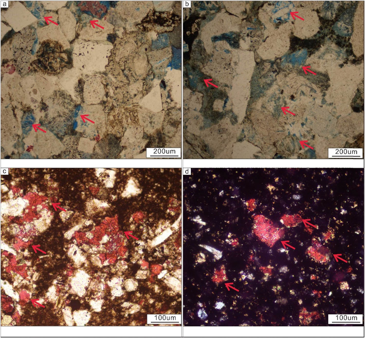
A special mineral, zeolite, was identified in the cementation mineral but is rare in ordinary sandstone. Zeolite cements in the Wuerhe Formation are primarily laumontite; laumontite is a commonly cementation material identified under rock slices and via SEM. Zeolite cements also have a dual effect on pores. Early zeolite cementation reduces pores, thus preventing damage by compaction and providing a material basis for later dissolution and pore growth (Figure 9).

Laumontite crystal under a SEM. (a) C-6, 6529.2 m, and (b) C-6, 6734.5 m.
Due to the change in interstitial materials in the reservoir, the anorthite contents in rock cuttings vary, albitization occurs, and the laumontite content increases. The reservoir cement has strong heterogeneity, and the laumontite content increases toward the depression’s center [53,54]. The element logging data show that the aluminum content decreases significantly, the sodium content increases significantly, and the potassium content increases slightly below 6,500 m from the bottom of the Wuerhe Formation, indicating that the albite in the mineral components of the reservoir increases while the shale content decreases. The plagioclase in the reservoir undergoes albitization and forms laumontite, thereby worsening the rock pores and increasing the density (Figure 10).

Comparison of the albite content in rocks at different depths.
5 Dissolution
The dissolution of sandstone in the study area is strong, and dissolution primarily occurs in the shallow area near the depression’s edge. Microcracks are easily produced in this region, the fluid is active, and the dissolution is strong. The area consists primarily of intergranular dissolution holes formed by intergranular fillings, such as calcite and laumontite. Furthermore, the dissolution of some rock debris, feldspar, and other particles occurs. The regional tectonic activity near the depression’s center was weak, and the rock dissolution was undeveloped here. Dissolution occurred only locally and mostly involved the dissolution of intergranular cementing minerals (Figure 11a and b). Metasomatism occurred based on particle dissolution. Later, calcite metasomatism became more common, with the metasomatism of clastic particles and interstitial fillings. Metasomatism can occur under different lithology and calcite contents (Figure 11c and d).
Dissolution and metasomatism of minerals. (a) Particle dissolution of minerals, C-6, 6528.3 m, (b) particle dissolution of minerals, C-6, 6528.3 m, (c) metasomatism of minerals, C-6, 6900.2 m, and (d) metasomatism of minerals, C-6, 6900.5 m.
5.1 Pore evolution law of sandstone
Due to the effects of the clastic type and compaction, the primary intergranular pores in the rock disappeared, and the amount of residual pores correlated well with the depth (Figure 12a and b). Dissolution pores are crucial, including intergranular and intragranular dissolution, and are affected by the sedimentary environment [55,56,57]. The dissolution of the upper Wuerhe Formation occurred primarily in the intergranular fillings supported by large particles, most of which were intergranular dissolution pores (Figure 12c). The feldspar content in the lower Wuerhe Formation increased, whereas the rock debris decreased, further weakening the effect of the occurrence of dissolution in grains. The interstitial material dissolution observed in the thin sections was higher than that observed in the grains (Figure 12d). In addition to dissolution pores, some microfractures occurred in the sandstone; these might have been related to strong compaction and tectonism. The fractures in the upper Wuerhe Formation are developed, and most of them are structural microfractures developed along the interface between the bedding and local intervals, along with a few high-angle fractures (Figure 12e). The fractures in the lower Wuerhe Formation are undeveloped, and a few microfractures and bedding fractures were observed. The fractures identified by imaging logging were primarily drilling-induced fractures (Figure 12f).

Pore types and characteristics of sandstone. Strong mechanical compaction, (a) C-6, 5470.2 m, (b) C-6, 6528.5 m. Different types of dissolution, (c) C-6, 6224.3 m, (d) C-6, 6528.5 m. Different types of micro-fracture, (e) C-6, 5490.2 m, (f) C-6, 6224.3 m.
According to core observation, casting thin section, and SEM analyses, the reservoir space of the upper Wuerhe Formation was found to include fractures (structural fractures and grain margin fractures), dissolution pores (cement dissolution pores and volcanic rock debris dissolution pores), residual intergranular pores, and micropores. Fractures are vital reservoir spaces of the glutenite reservoirs of the upper Wuerhe Formation. The pores and fractures of the lower Wuerhe Formation (primarily corrosion pores) are undeveloped (Figure 13).

Percentages of different pore types.
The analysis and test data show that the maximum porosity of the upper Wuerhe Formation is 17%, with an average porosity of approximately 10%. The porosity of the lower formation is small, with an average porosity of 8%, and gradually decreases with increasing depth. Most reservoirs have low porosity and low permeability levels. The connectivity between the pores in the study area is very poor; most of the pores are isolated and small, with no connectivity. The throat type of the reservoir is dominated by variable section shrinkage, followed by flaky or curved flaky throats, and some pores are guided by microfractures. Compared to the pore evolution laws identified in other sags of the Junggar Basin, study areas T and P primarily developed glutenite and pebbly sandstone reservoirs, and there is a possibility of the presence of good reservoirs in the middle-deep layers. The physical properties of the reservoirs in the Wuerhe Formation change with depth, but the change amplitudes are small, and fractures are developed in local intervals. The pore evolution of the Wuerhe Formation reservoir of Well Cheng-6 follows the normal compaction curve (fitted from the stratigraphic parameters of normal compaction in the Mahu Depression within the Junggar Basin), and high-permeability “sweet spots” appear only locally, in contrast from the western uplift area (Figure 14a). It can also be concluded from the NMR experimental data analyzing that as the depth increases, the fluctuation amplitude of the NMR curve gradually decreases, and its right peak decreases significantly until it disappears. This indicates that the permeability of the rock has decreased, and at the same time, the proportion of movable fluid in the pores has gradually decreased, which is the consequence of compaction (Figure 14b).

Vertical evolution law of sandstone pores. (a) Relationship between porosity and depth and (b) Nuclear Magnetic Resonance T2 spectrum.
5.2 Division of diagenetic facies
Taking mineral components as variables, the reservoir in the study area was analyzed using R-type factor analysis; this analysis method combines the R-type analysis of the correlation analysis of influencing factors with the Q-type analysis of the correlation analysis of strata to calculate the load matrix of two factors and form a cluster comprising both the influencing factors and strata. Based on the results, the correlations between the strata and influencing factors were studied [58]. According to the calculation results of the contribution rate, the R–Q factor analysis was conducted by selecting quartz, feldspar, rock debris, carbonate rock cement, clay minerals, and laumontite factors. After eight iterations, convergence was achieved, the eigenvalues of the matrix composed of the correlation coefficients among the variables were taken, and the cumulative square error was calculated [59]. Table 2 shows the contribution rates of the R–Q analysis eigenvalues. The data analysis shows that the eigenvalues of the selected parameters were proportional to the amount of information the parameters carried.
Contribution rates of the R–Q factor analysis eigenvalues in diagenesis
| Factor | Characteristic value | Contribution rate (%) | Cumulative contribution rate (%) |
|---|---|---|---|
| Quartz | 24.32 | 82.27 | 82.27 |
| Feldspar | 3.44 | 11.64 | 93.91 |
| debris | 1.12 | 3.79 | 97.70 |
| Carbonate rock cement | 0.64 | 2.17 | 99.86 |
| Laumontite | 0.04 | 0.14 | 100.00 |
| Clay minerals | 0 | 0.00 | 100.00 |
According to the factor analysis results, the diagenetic facies of sandstones in the study area were divided into mechanical compaction, unstable clastic dissolution, carbonate cementation, and laumontite cementation diagenetic facies. Due to sedimentation, the sandstone diagenesis types near the provenance and far from the provenance differ. With the advanced provenance and the increased burial depth, the facies show a specific change rule (Figure 15a). The mechanical compaction facies are the primary factor reducing the rock porosity, and the other three types are the primary dominant diagenetic facies types. The sandstone near the source area is gravelly. These large gravels provide favorable conditions for retaining pores, and this is conducive to later fluid injection. Therefore, the dissolution of unstable debris is crucial in the diagenetic evolution of rocks. Most pores are filled with large debris particles with small shale contents (Figure 15b). The cementation of carbonate rock minerals and clay minerals primarily occurs in the fan delta front subfacies. The pores in this area are moderately developed, and the shale content is high. However, due to the dissolution of cement, numerous pores were generated (Figure 15c). The dissolution of laumontite in the depression’s central area is advantageous. The feldspar minerals in these pores partially or wholly dissolved under specific conditions, and the generated zeolite minerals became unstable and prone to dissolution. Therefore, a development zone of secondary pores appeared in the lithofacies-controlled area. The area developed with rich argillaceous sandstone or pebbly sandstone, under high rock compression conditions challenging for pore retention (Figure 15d).

Division and evolution of the diagenetic facies of the Wuerhe Formation. (a) Division of diagenetic evolution; (b–d) pore structure pattern.
6 Conclusions
Tectonic activity was weak in the study area during the deposition of the Permian Wuerhe Formation, and fan delta sedimentation occurred. The provenance corresponded to the northeast protrusion. The sedimentary thickness continuously thinned from southwest to northeast, with a maximum burial depth of approximately 7,500 m. The reservoir lithology was sandy conglomerate, sandstone, and siltstone, and the rock debris content was high.
The diagenesis of the Wuerhe Formation included compaction, cementation, and dissolution processes. The compaction intensity was high, resulting in the high density of the reservoir sandstone. The cementation materials included carbonate rock and laumontite. Dissolution occurred primarily in the interstitial materials and unstable clasts, and the clast dissolution process involved feldspar and rock debris.
The reservoir’s primary pores have disappeared. The primary pore types include dissolution pores of unstable clastic and interstitial materials, most of which are small pores and micropores with poor connectivity. With increasing depth, the porosity and permeability decrease considerably, and no obvious secondary pore zone appears. Diagenesis had the greatest impact on the reservoir’s later densification. The diagenetic facies that played a leading role in pore enlargement were the unstable clastic and cementation mineral dissolution facies.
Acknowledgments
The authors would like to thank the workers of Shengli Oilfield of Sinopec for supplying research data. This work was supported by the Natural Science Foundation of Shandong Province (ZR2020MD035) and the National Natural Science Foundation of China (51504143 and 51674156).
-
Funding information: Authors state no funding involved.
-
Author contributions: Shasha Guo: conceptualization, project administration, data analysis, and writing; Xuecai Zhang: resources, sorting, and writing; Jue Wang: methodology, writing, and revising; Siwen Wang: writing and revising; Kemin Liu: writing and revising; and Jinkai Wang: conceptualization, methodology, writing, and reviewing.
-
Conflict of interest: The authors declare that they have no known competing financial interests or personal relationships that could have appeared to influence the work reported in this article.
References
[1] Zhi D, Tang Y, He W, Guo X, Zheng M, Huang L. Orderly coexistence and accumulation models of conventional and unconventional hydrocarbons in Lower Permian Fengcheng Formation, Mahu sag, Junggar Basin. Pet Explor Dev. 2021;48(1):43–59.10.1016/S1876-3804(21)60004-6Search in Google Scholar
[2] Duan W, Shi L, Luo CF, Li S. Hydrocarbon accumulation mechanism in the far-source reservoirs of Dongsha Uplift of the Pearl River Mouth Basin, northern South China Sea. J Pet Sci Eng. 2023;220:111145.10.1016/j.petrol.2022.111145Search in Google Scholar
[3] Liu X, Liu W, Si C. Petrogenesis and source rocks of the high-K calc-alkaline and shoshonitic I-type granitoids in the northwestern part of East Junggar, NW China. Lithos. 2019;326:298–312.10.1016/j.lithos.2018.12.033Search in Google Scholar
[4] Zhang H, Cheng L, Fan H, Wang G, Mao R, Mu L, et al. Formation overpressure and its influence on physical properties in Mahu sag, Junggar Basin. Prog Geophysics. 2022;37(3):1223–7.Search in Google Scholar
[5] Li J, Zhang W, Xiang B, He D, Yang S, Wang J, et al. LCharacteristics of dissolved pores and dissolution mechanism of zeolite-rich reservoirs in the Wuerhe Formation in Mahu area, Junggar Basin. Energy Explor Exploitation. 2022;40(1):421–41.10.1177/01445987211028732Search in Google Scholar
[6] Hu D, Rao S, Wang ZT, Hu SB. Thermal and maturation history for Carboniferous source rocks in the Junggar Basin, Northwest China: implications for hydrocarbon exploration. Pet Sci. 2020;17:36–50.10.1007/s12182-019-00392-2Search in Google Scholar
[7] Tao K, Cao J, Chen X, Nueraili Z, Hu W, Shi C. Deep hydrocarbons in the northwestern Junggar Basin (NW China): Geochemistry, origin, and implications for the oil vs. gas generation potential of post-mature saline lacustrine source rocks. Mar Pet Geol. 2019;109:623–40.10.1016/j.marpetgeo.2019.06.041Search in Google Scholar
[8] Wang Z, Luo X, Lei Y, Zhang L, Shi H, Lu J, et al. Impact of detrital composition and diagenesis on the heterogeneity and quality of low-permeability to tight sandstone reservoirs: An example of the Upper Triassic Yanchang Formation in Southeastern Ordos Basin. J Pet Sci Eng. 2020;195:107596.10.1016/j.petrol.2020.107596Search in Google Scholar
[9] Wang J, Tan X, Tian J, Luo L, Gao X, Luo C, et al. The effect of diagenetic evolution on shale gas exploration and development of the Longmaxi Formation Shale, Sichuan Basin, China. Front Earth Sci. 2021;9:661581.10.3389/feart.2021.661581Search in Google Scholar
[10] Li N, Yang X, Peng J, Zhou Q, Su Z. Deep-water bottom current evolution in the northern South China Sea during the last 150 kyr: evidence from sortable-silt grain size and sedimentary magnetic fabric. J Asian Earth Sci. 2017;19:78–87.10.1016/j.jseaes.2017.06.005Search in Google Scholar
[11] Hansen JA, Mondol NH, Jahren J, Tsikalas F. Reservoir assessment of Middle Jurassic sandstone-dominated formations in the Egersund Basin and Ling Depression, eastern Central North Sea. Mar Pet Geol. 2020;111:529–43.10.1016/j.marpetgeo.2019.08.044Search in Google Scholar
[12] Wang J, Zhou L, Liu J, Zhang X, Zhang F, Zhang B. Acid-base alternation diagenesis and its influence on shale reservoirs in the Permian Lucaogou Formation, Jimusar Sag, Junggar Basin, NW China. Pet Explor Dev. 2020;5:962–76.10.1016/S1876-3804(20)60109-4Search in Google Scholar
[13] Liang P, Chen H, Zhao L, Wu C, Xie Y, Lai CK. Deciphering fluid origins in the Paleozoic Laoshankou Fe-Cu-Au deposit, East Junggar: Constraints from noble gases and halogens. Geosci Front. 2021;12(5):69–80.10.1016/j.gsf.2021.101173Search in Google Scholar
[14] Zhou J, Li W. Evolution and metallogeny of the Sanjiang arc-back arc basin system in the Eastern Tethys: An introduction. J Asian Earth Sci. 2021;222:104961.10.1016/j.jseaes.2021.104961Search in Google Scholar
[15] Yao ZQ, Yang F, Jianatayi D, Wang W, Gao Y, Sun L, et al. Application of multi-attribute matching technology based on geological models for sedimentary facies:A case study of the 3rd member in the Lower Jurassic Badaowan Formation, Hongshanzui area, Junggar Basin, China. Pet Sci. 2022;19(1):116–27.10.1016/j.petsci.2021.10.008Search in Google Scholar
[16] Van Dijk M, Kleinhans MG, Postma G, Kraal E. Contrasting morphodynamics in alluvial fans and fan deltas: effect of the downstream boundary. Sedimentology. 2012;59(7):2125–45.10.1111/j.1365-3091.2012.01337.xSearch in Google Scholar
[17] Song F, Su N, Kong X, Liu C, Song C. Sedimentary characteristics of humid alluvial fan and its control on hydrocarbon accumulation: A case study on the northern margin of the Junggar Basin, west China. J Pet Sci Eng. 2020;187:106729.10.1016/j.petrol.2019.106729Search in Google Scholar
[18] Gao C, Ji Y, Wu C, Jin J, Ren Y, Yang Z, et al. Facies and depositional model of alluvial fan dominated by episodic flood events in arid conditions: An example from the Quaternary Poplar Fan, north-western China. Sedimentology. 2020;67(4):1750–96.10.1111/sed.12684Search in Google Scholar
[19] Owen LA, Clemmens SJ, Finkel RC, Gray H. Late Quaternary alluvial fans at the eastern end of the San Bernardino Mountains, Southern California. Quat Sci Rev: Int Multidiscip Rev J. 2014;87:114–34.10.1016/j.quascirev.2014.01.003Search in Google Scholar
[20] Zhang Y, Dai X, Wang M, Li X. The concept, characteristics and significance of fluvial fans. Pet Explor Dev. 2020;47(5):1014–26.10.1016/S1876-3804(20)60113-6Search in Google Scholar
[21] Eakin AL, Reece JS, Milliken KL, Locklair R, Rathbun AP. Classification of elemental chemofacies as indicators of cement diagenesis in mudrocks of the Permian Spraberry Formation and Wolfcamp formation, western Texas. AAPG Bull. 2023;107(6):863–86.10.1306/10242221142Search in Google Scholar
[22] Mu N. Impact of meteoric water flushing on diagenesis of deep-marine turbidite sandstones: A case study from the Tertiary sandstones of Frigg and Grane fields, northern North sea. Mar Pet Geol. 2023;150:106116.10.1016/j.marpetgeo.2023.106116Search in Google Scholar
[23] Fan C, Nie S, Li H, Radwan AE, Pan Q, Shi X, et al. Quantitative prediction and spatial analysis of structural fractures in deep shale gas reservoirs within complex structural zones: A case study of the Longmaxi Formation in the Luzhou area, southern Sichuan Basin, China. J Asian Earthscience. 2024;263:106025.10.1016/j.jseaes.2024.106025Search in Google Scholar
[24] Wang G, Li P, Hao F, Zou H, Zhang L, Yu X. Impact of sedimentology, diagenesis, and solid bitumen on the development of a tight gas grainstone reservoir in the Feixianguan Formation, Jiannan area, China: Implications for gas exploration in tight carbonate reservoirs. Mar Pet Geol. 2015;64:250–65.10.1016/j.marpetgeo.2015.02.045Search in Google Scholar
[25] Zhang D, Wang S, Zhao W, Fan ZF, Li ZP. The main geological control factors of single well productivity for carbonate reservoir: Take the reservoir formation KT-I in North Truva field, Kazakhstan as example. Acta Petrol Sin. 2016;32(3):903–14.Search in Google Scholar
[26] Zhang Z, Lv D, Hower JC, Wang L, Shen Y, Zhang A, et al. Geochronology, mineralogy, and geochemistry of tonsteins from the Pennsylvanian Taiyuan Formation of the Jungar Coalfield, Ordos Basin, North China. Int J Coal Geol. 2023;267:104183.10.1016/j.coal.2023.104183Search in Google Scholar
[27] Wu J, Fan T, Gomez-Rivas E, Travé A, Cao Q, Gao Z, et al. Impact of diagenesis on the pore evolution and sealing capacity of carbonate cap rocks in the Tarim Basin, China. AAPG Bull. 2022;106(12):2471–2511.10.1306/11082120136Search in Google Scholar
[28] Enayati-Bidgoli A, Saemi E. Effects of late diagenesis on primary reservoir quality of a quartz arenite unit: a case study from the lower Cretaceous successions of SW Iran. Pet Sci. 2022;16(2):267–84.10.1007/s12182-019-0306-xSearch in Google Scholar
[29] Hart B, Schieber J, Kalinec J. Clay diagenesis and overpressure development in Upper Cretaceous and Tertiary shales of South Texas. Mar Pet Geol. 2023;147:105978.10.1016/j.marpetgeo.2022.105978Search in Google Scholar
[30] Shi P, Tang H, Wang Z, Sha X, Wei H, Liu C. Carbonate diagenesis in fourth-order sequences: A case study of yingshan formation (Lower Ordovician) from the yubei area -Tarim Basin, NW China a. J Pet Sci Eng. 2020;195:1077569.10.1016/j.petrol.2020.107756Search in Google Scholar
[31] Chen L. A study on the inhomogeneous sedimentation-diagenesis- reservoir formation mode of deep tight marine clastic rock reservoirs in the Silurian Xiaoheba Formation, Southeast Sichuan. Front Earth Sci. 2022;10:900188-17807.10.3389/feart.2022.900188Search in Google Scholar
[32] Buckman J, Higgins S. A simple effective method for three-dimensional modelling of cementation, fracturing and dissolution of carbonate rocks: Illustrated through oolitic limestone. Geosciences. 2019;9(6):246.10.3390/geosciences9060246Search in Google Scholar
[33] Li Y, Xu W, Wu P, Meng S. Dissolution versus cementation and its role in determining tight sandstone quality: a case study from the Upper Paleozoic in northeastern Ordos Basin, China. J Nat Gas Sci Eng. 2020;78:103324.10.1016/j.jngse.2020.103324Search in Google Scholar
[34] Romano C, Williams R, Cheng F. Evolution of fault-zone hydromechanical properties in response to different cementation processes. Lithosphere. 2022;2022(1):1069843.10.2113/2022/1069843Search in Google Scholar
[35] Yu Z, Wang Z, Wang J, Li Z. Subtle reservoirs and implications for hydrocarbon exploration in terrestrial lacustrine fan-delta deposits: Insights from the Triassic Baikouquan Formation, Mahu Sag, Junggar Basin, western China. Mar Pet Geol. 2022;142:105730.10.1016/j.marpetgeo.2022.105730Search in Google Scholar
[36] Zhang Y, Jiang S, He Z, Wang Y, Guo M, Zhu G, et al. Characteristics of heterogeneous diagenesis and modification to physical properties of Upper Paleozoic tight gas reservoir in eastern Ordos Basin. J Pet Sci Eng. 2022;208:109243.10.1016/j.petrol.2021.109243Search in Google Scholar
[37] Huang H, Li J, Yang H, Zhang G, Gao R, An J, et al. Influence of diapir structure on formation and distribution of overpressure in the Yinggehai Basin. South China Sea Energy Sci Eng. 2022;10(7):1972–85.10.1002/ese3.1157Search in Google Scholar
[38] Yin J, Wei L, Sun S, Shi Z, Dong D, Gao Z. Overpressure generation and evolution in deep longmaxi formation shale reservoir in Southern Sichuan Basin: Influences on pore development. Energies. 2023;16(6):2533.10.3390/en16062533Search in Google Scholar
[39] Du H, Liu Y, Li X. Interpreting reservoir permeabilities from wireline formation test data. Pet Sci Technol. 2013;31(17/20):1819–26.10.1080/10916466.2011.603009Search in Google Scholar
[40] Guo X, Hu D, Li Y, Liu R, Wang Q. Geological features and reservoiring mode of shale gas reservoirs in longmaxi formation of the Jiaoshiba Area. Acta Geol Sin – Engl Ed. 2014;88(6):1811–21.10.1111/1755-6724.12347Search in Google Scholar
[41] Luo Y, Wang Y, Liu H, Wang G, Zhao Y. Overpressure controlling factors for tectonic fractures in near-source tight reservoirs in the southwest Ordos Basin, China. J Pet Sci Eng. 2020;188:106818.10.1016/j.petrol.2019.106818Search in Google Scholar
[42] LI W, Chen Z, Huang P, Yu Z, Min L, Lu X. Formation of overpressure system and its relationship with the distribution of large gas fields in typical foreland basins in central and western China. Pet Explor Dev. 2021;48(3):625–40.10.1016/S1876-3804(21)60050-2Search in Google Scholar
[43] Zhao S, Li S, Liu X, Suo Y, Dai L, Lou D, et al. Intracontinental orogenic transition: Insights from structures of the eastern Junggar Basin between the Altay and Tianshan orogens. J Asian Earth Sci. 2014;88:137–48.10.1016/j.jseaes.2014.03.008Search in Google Scholar
[44] Ding Z, Wang R, Chen F, Yang J, Zhu Z, Yang Z, et al. Origin, hydrocarbon accumulation and oil-gas enrichment of fault-karst carbonate reservoirs: A case study of Ordovician carbonate reservoirs in South Tahe area of Halahatang oilfield, Tarim Basin. Pet Explor Dev. 2020, 47(2):306–17.10.1016/S1876-3804(20)60048-9Search in Google Scholar
[45] Xu C, Yang H, Wang D, Zhao D, Wang L. Formation conditions of Neogene large-scale high-abundance lithologic reservoir in the Laibei low uplift, Bohai Sea, East China. Pet Explor Dev. 2021;48(1):15–29.10.1016/S1876-3804(21)60002-2Search in Google Scholar
[46] You L, Xu S, Mao X, Zhong J, Jiao Y, Xiong X. Reservoir Characteristics and Genetic Mechanisms of the Mesozoic Granite Buried Hills in the Deep-water of the Qiongdongnan Basin. Acta Geol Sin – Engl Ed. 2021;95(1):259–67.10.1111/1755-6724.14635Search in Google Scholar
[47] Yang Z, He S, Li Q, Lin S, Pan S. Geochemistry characteristics and significance of two petroleum systems near top overpressured surface in central Junggar Basin, NW China. Mar Pet Geol. 2016;75:341–55.10.1016/j.marpetgeo.2016.04.025Search in Google Scholar
[48] Lai F, Li Z, Zhang T, Zhou A, Gong B. Characteristics of microscopic pore structure and its influence on spontaneous imbibition of tight gas reservoir in the Ordos Basin, China. J Pet Sci Eng. 2019;172:23–31.10.1016/j.petrol.2018.09.020Search in Google Scholar
[49] Wang H, Liao X, Dou X, Shang B, Ye H, Zhao D, et al. Potential Evaluation of CO2 Sequestration and Enhanced Oil Recovery of Low Permeability Reservoir in the Junggar Basin, China. Energy Fuels. 2014;28(5):3281–91.10.1021/ef4025068Search in Google Scholar
[50] Hu H, Tian X, Zhang J, Zhuo Q, Jia C, Guo Z. The diagenetic and tectonic significance of hydrocarbon accumulation in the southern Junggar Basin, NW China. Geol J. 2018;53(6):2795–809.10.1002/gj.3119Search in Google Scholar
[51] Changmin Z, Rui Z, Kang Z. From end member to continuum: review of fluvial facies model research. Acta Sedimentol Sin. 2017;35(5):926–44.Search in Google Scholar
[52] Li Y, Lu J, Liu X, Wang J, Ma W, He X, et al. Geochemistry and origins of natural gas in the Hong-Che fault zone of the Junggar Basin, NW China. J Pet Sci Eng. 2022;214:110501.10.1016/j.petrol.2022.110501Search in Google Scholar
[53] Cai J, Li C, Song K, Zou S, Yang Z, Shen Y, et al. The influence of salinity and mineral components on spontaneous imbibition in tight sandstone. Fuel. 2020;269:117087.10.1016/j.fuel.2020.117087Search in Google Scholar
[54] Chen B, Xu B, Li B, Kong M, Wang W, Chen H. Understanding the performance of hydraulically fractured wells in the laumontite-rich tight glutenite formation. J Pet Sci Eng. 2020;185:106600.10.1016/j.petrol.2019.106600Search in Google Scholar
[55] Liang C, Jiang Z, Cao Y, Wu M, Guo L, Zhang C. Deep-water depositional mechanisms and significance for unconventional hydrocarbon exploration: A case study from the lower Silurian Longmaxi shale in the southeastern Sichuan Basin. AAPG Bull. 2016;100(5):773–94.10.1306/02031615002Search in Google Scholar
[56] Yuan R, Zhang C, Tang Y, Qu J, Guo X, Sun Y, et al. Utilizing borehole electrical images to interpret lithofacies of fan-delta: A case study of Lower Triassic Baikouquan Formation in Mahu Depression, Junggar Basin, China. Open Geosci. 2017;9(1):539–53.10.1515/geo-2017-0041Search in Google Scholar
[57] Pan B, Chen H, Lin L, Yu Y, Wu D, Dong Y. Diagenesis and reservoir quality of the second member of the Upper Triassic Xujiahe Formation tight gas sandstones in the Western Sichuan Depression, southwest China. Geol J. 2021;56(6):3187–206.10.1002/gj.4088Search in Google Scholar
[58] Wang J, Feng X, Wanyan Q, Zhao K, Wang Z, Pei G, et al. Hysteresis effect of three-phase fluids in the high-intensity injection–production process of sandstone underground gas storages. Energy. 2022;242:123058.10.1016/j.energy.2021.123058Search in Google Scholar
[59] Wang B, Zhao J, Li W, Huang Y, Yin L, Xu D. Experimental study on the effect of abnormal high pressure on the elastic properties of glutenite and a novel pressure prediction model: a case study from Triassic Formation in north slope of Mahu Sag, Junggar Basin. Chin J Geophys – Chin Ed. 2022;65(8):3157–71.Search in Google Scholar
© 2024 the author(s), published by De Gruyter
This work is licensed under the Creative Commons Attribution 4.0 International License.
Articles in the same Issue
- Regular Articles
- Theoretical magnetotelluric response of stratiform earth consisting of alternative homogeneous and transitional layers
- The research of common drought indexes for the application to the drought monitoring in the region of Jin Sha river
- Evolutionary game analysis of government, businesses, and consumers in high-standard farmland low-carbon construction
- On the use of low-frequency passive seismic as a direct hydrocarbon indicator: A case study at Banyubang oil field, Indonesia
- Water transportation planning in connection with extreme weather conditions; case study – Port of Novi Sad, Serbia
- Zircon U–Pb ages of the Paleozoic volcaniclastic strata in the Junggar Basin, NW China
- Monitoring of mangrove forests vegetation based on optical versus microwave data: A case study western coast of Saudi Arabia
- Microfacies analysis of marine shale: A case study of the shales of the Wufeng–Longmaxi formation in the western Chongqing, Sichuan Basin, China
- Multisource remote sensing image fusion processing in plateau seismic region feature information extraction and application analysis – An example of the Menyuan Ms6.9 earthquake on January 8, 2022
- Identification of magnetic mineralogy and paleo-flow direction of the Miocene-quaternary volcanic products in the north of Lake Van, Eastern Turkey
- Impact of fully rotating steel casing bored pile on adjacent tunnels
- Adolescents’ consumption intentions toward leisure tourism in high-risk leisure environments in riverine areas
- Petrogenesis of Jurassic granitic rocks in South China Block: Implications for events related to subduction of Paleo-Pacific plate
- Differences in urban daytime and night block vitality based on mobile phone signaling data: A case study of Kunming’s urban district
- Random forest and artificial neural network-based tsunami forests classification using data fusion of Sentinel-2 and Airbus Vision-1 satellites: A case study of Garhi Chandan, Pakistan
- Integrated geophysical approach for detection and size-geometry characterization of a multiscale karst system in carbonate units, semiarid Brazil
- Spatial and temporal changes in ecosystem services value and analysis of driving factors in the Yangtze River Delta Region
- Deep fault sliding rates for Ka-Ping block of Xinjiang based on repeating earthquakes
- Improved deep learning segmentation of outdoor point clouds with different sampling strategies and using intensities
- Platform margin belt structure and sedimentation characteristics of Changxing Formation reefs on both sides of the Kaijiang-Liangping trough, eastern Sichuan Basin, China
- Enhancing attapulgite and cement-modified loess for effective landfill lining: A study on seepage prevention and Cu/Pb ion adsorption
- Flood risk assessment, a case study in an arid environment of Southeast Morocco
- Lower limits of physical properties and classification evaluation criteria of the tight reservoir in the Ahe Formation in the Dibei Area of the Kuqa depression
- Evaluation of Viaducts’ contribution to road network accessibility in the Yunnan–Guizhou area based on the node deletion method
- Permian tectonic switch of the southern Central Asian Orogenic Belt: Constraints from magmatism in the southern Alxa region, NW China
- Element geochemical differences in lower Cambrian black shales with hydrothermal sedimentation in the Yangtze block, South China
- Three-dimensional finite-memory quasi-Newton inversion of the magnetotelluric based on unstructured grids
- Obliquity-paced summer monsoon from the Shilou red clay section on the eastern Chinese Loess Plateau
- Classification and logging identification of reservoir space near the upper Ordovician pinch-out line in Tahe Oilfield
- Ultra-deep channel sand body target recognition method based on improved deep learning under UAV cluster
- New formula to determine flyrock distance on sedimentary rocks with low strength
- Assessing the ecological security of tourism in Northeast China
- Effective reservoir identification and sweet spot prediction in Chang 8 Member tight oil reservoirs in Huanjiang area, Ordos Basin
- Detecting heterogeneity of spatial accessibility to sports facilities for adolescents at fine scale: A case study in Changsha, China
- Effects of freeze–thaw cycles on soil nutrients by soft rock and sand remodeling
- Vibration prediction with a method based on the absorption property of blast-induced seismic waves: A case study
- A new look at the geodynamic development of the Ediacaran–early Cambrian forearc basalts of the Tannuola-Khamsara Island Arc (Central Asia, Russia): Conclusions from geological, geochemical, and Nd-isotope data
- Spatio-temporal analysis of the driving factors of urban land use expansion in China: A study of the Yangtze River Delta region
- Selection of Euler deconvolution solutions using the enhanced horizontal gradient and stable vertical differentiation
- Phase change of the Ordovician hydrocarbon in the Tarim Basin: A case study from the Halahatang–Shunbei area
- Using interpretative structure model and analytical network process for optimum site selection of airport locations in Delta Egypt
- Geochemistry of magnetite from Fe-skarn deposits along the central Loei Fold Belt, Thailand
- Functional typology of settlements in the Srem region, Serbia
- Hunger Games Search for the elucidation of gravity anomalies with application to geothermal energy investigations and volcanic activity studies
- Addressing incomplete tile phenomena in image tiling: Introducing the grid six-intersection model
- Evaluation and control model for resilience of water resource building system based on fuzzy comprehensive evaluation method and its application
- MIF and AHP methods for delineation of groundwater potential zones using remote sensing and GIS techniques in Tirunelveli, Tenkasi District, India
- New database for the estimation of dynamic coefficient of friction of snow
- Measuring urban growth dynamics: A study in Hue city, Vietnam
- Comparative models of support-vector machine, multilayer perceptron, and decision tree predication approaches for landslide susceptibility analysis
- Experimental study on the influence of clay content on the shear strength of silty soil and mechanism analysis
- Geosite assessment as a contribution to the sustainable development of Babušnica, Serbia
- Using fuzzy analytical hierarchy process for road transportation services management based on remote sensing and GIS technology
- Accumulation mechanism of multi-type unconventional oil and gas reservoirs in Northern China: Taking Hari Sag of the Yin’e Basin as an example
- TOC prediction of source rocks based on the convolutional neural network and logging curves – A case study of Pinghu Formation in Xihu Sag
- A method for fast detection of wind farms from remote sensing images using deep learning and geospatial analysis
- Spatial distribution and driving factors of karst rocky desertification in Southwest China based on GIS and geodetector
- Physicochemical and mineralogical composition studies of clays from Share and Tshonga areas, Northern Bida Basin, Nigeria: Implications for Geophagia
- Geochemical sedimentary records of eutrophication and environmental change in Chaohu Lake, East China
- Research progress of freeze–thaw rock using bibliometric analysis
- Mixed irrigation affects the composition and diversity of the soil bacterial community
- Examining the swelling potential of cohesive soils with high plasticity according to their index properties using GIS
- Geological genesis and identification of high-porosity and low-permeability sandstones in the Cretaceous Bashkirchik Formation, northern Tarim Basin
- Usability of PPGIS tools exemplified by geodiscussion – a tool for public participation in shaping public space
- Efficient development technology of Upper Paleozoic Lower Shihezi tight sandstone gas reservoir in northeastern Ordos Basin
- Assessment of soil resources of agricultural landscapes in Turkestan region of the Republic of Kazakhstan based on agrochemical indexes
- Evaluating the impact of DEM interpolation algorithms on relief index for soil resource management
- Petrogenetic relationship between plutonic and subvolcanic rocks in the Jurassic Shuikoushan complex, South China
- A novel workflow for shale lithology identification – A case study in the Gulong Depression, Songliao Basin, China
- Characteristics and main controlling factors of dolomite reservoirs in Fei-3 Member of Feixianguan Formation of Lower Triassic, Puguang area
- Impact of high-speed railway network on county-level accessibility and economic linkage in Jiangxi Province, China: A spatio-temporal data analysis
- Estimation model of wild fractional vegetation cover based on RGB vegetation index and its application
- Lithofacies, petrography, and geochemistry of the Lamphun oceanic plate stratigraphy: As a record of the subduction history of Paleo-Tethys in Chiang Mai-Chiang Rai Suture Zone of Thailand
- Structural features and tectonic activity of the Weihe Fault, central China
- Application of the wavelet transform and Hilbert–Huang transform in stratigraphic sequence division of Jurassic Shaximiao Formation in Southwest Sichuan Basin
- Structural detachment influences the shale gas preservation in the Wufeng-Longmaxi Formation, Northern Guizhou Province
- Distribution law of Chang 7 Member tight oil in the western Ordos Basin based on geological, logging and numerical simulation techniques
- Evaluation of alteration in the geothermal province west of Cappadocia, Türkiye: Mineralogical, petrographical, geochemical, and remote sensing data
- Numerical modeling of site response at large strains with simplified nonlinear models: Application to Lotung seismic array
- Quantitative characterization of granite failure intensity under dynamic disturbance from energy standpoint
- Characteristics of debris flow dynamics and prediction of the hazardous area in Bangou Village, Yanqing District, Beijing, China
- Rockfall mapping and susceptibility evaluation based on UAV high-resolution imagery and support vector machine method
- Statistical comparison analysis of different real-time kinematic methods for the development of photogrammetric products: CORS-RTK, CORS-RTK + PPK, RTK-DRTK2, and RTK + DRTK2 + GCP
- Hydrogeological mapping of fracture networks using earth observation data to improve rainfall–runoff modeling in arid mountains, Saudi Arabia
- Petrography and geochemistry of pegmatite and leucogranite of Ntega-Marangara area, Burundi, in relation to rare metal mineralisation
- Prediction of formation fracture pressure based on reinforcement learning and XGBoost
- Hazard zonation for potential earthquake-induced landslide in the eastern East Kunlun fault zone
- Monitoring water infiltration in multiple layers of sandstone coal mining model with cracks using ERT
- Study of the patterns of ice lake variation and the factors influencing these changes in the western Nyingchi area
- Productive conservation at the landslide prone area under the threat of rapid land cover changes
- Sedimentary processes and patterns in deposits corresponding to freshwater lake-facies of hyperpycnal flow – An experimental study based on flume depositional simulations
- Study on time-dependent injectability evaluation of mudstone considering the self-healing effect
- Detection of objects with diverse geometric shapes in GPR images using deep-learning methods
- Behavior of trace metals in sedimentary cores from marine and lacustrine environments in Algeria
- Spatiotemporal variation pattern and spatial coupling relationship between NDVI and LST in Mu Us Sandy Land
- Formation mechanism and oil-bearing properties of gravity flow sand body of Chang 63 sub-member of Yanchang Formation in Huaqing area, Ordos Basin
- Diagenesis of marine-continental transitional shale from the Upper Permian Longtan Formation in southern Sichuan Basin, China
- Vertical high-velocity structures and seismic activity in western Shandong Rise, China: Case study inspired by double-difference seismic tomography
- Spatial coupling relationship between metamorphic core complex and gold deposits: Constraints from geophysical electromagnetics
- Disparities in the geospatial allocation of public facilities from the perspective of living circles
- Research on spatial correlation structure of war heritage based on field theory. A case study of Jinzhai County, China
- Formation mechanisms of Qiaoba-Zhongdu Danxia landforms in southwestern Sichuan Province, China
- Magnetic data interpretation: Implication for structure and hydrocarbon potentiality at Delta Wadi Diit, Southeastern Egypt
- Deeply buried clastic rock diagenesis evolution mechanism of Dongdaohaizi sag in the center of Junggar fault basin, Northwest China
- Application of LS-RAPID to simulate the motion of two contrasting landslides triggered by earthquakes
- The new insight of tectonic setting in Sunda–Banda transition zone using tomography seismic. Case study: 7.1 M deep earthquake 29 August 2023
- The critical role of c and φ in ensuring stability: A study on rockfill dams
- Evidence of late quaternary activity of the Weining-Shuicheng Fault in Guizhou, China
- Extreme hydroclimatic events and response of vegetation in the eastern QTP since 10 ka
- Spatial–temporal effect of sea–land gradient on landscape pattern and ecological risk in the coastal zone: A case study of Dalian City
- Study on the influence mechanism of land use on carbon storage under multiple scenarios: A case study of Wenzhou
- A new method for identifying reservoir fluid properties based on well logging data: A case study from PL block of Bohai Bay Basin, North China
- Comparison between thermal models across the Middle Magdalena Valley, Eastern Cordillera, and Eastern Llanos basins in Colombia
- Mineralogical and elemental analysis of Kazakh coals from three mines: Preliminary insights from mode of occurrence to environmental impacts
- Chlorite-induced porosity evolution in multi-source tight sandstone reservoirs: A case study of the Shaximiao Formation in western Sichuan Basin
- Predicting stability factors for rotational failures in earth slopes and embankments using artificial intelligence techniques
- Origin of Late Cretaceous A-type granitoids in South China: Response to the rollback and retreat of the Paleo-Pacific plate
- Modification of dolomitization on reservoir spaces in reef–shoal complex: A case study of Permian Changxing Formation, Sichuan Basin, SW China
- Geological characteristics of the Daduhe gold belt, western Sichuan, China: Implications for exploration
- Rock physics model for deep coal-bed methane reservoir based on equivalent medium theory: A case study of Carboniferous-Permian in Eastern Ordos Basin
- Enhancing the total-field magnetic anomaly using the normalized source strength
- Shear wave velocity profiling of Riyadh City, Saudi Arabia, utilizing the multi-channel analysis of surface waves method
- Effect of coal facies on pore structure heterogeneity of coal measures: Quantitative characterization and comparative study
- Inversion method of organic matter content of different types of soils in black soil area based on hyperspectral indices
- Detection of seepage zones in artificial levees: A case study at the Körös River, Hungary
- Tight sandstone fluid detection technology based on multi-wave seismic data
- Characteristics and control techniques of soft rock tunnel lining cracks in high geo-stress environments: Case study of Wushaoling tunnel group
- Influence of pore structure characteristics on the Permian Shan-1 reservoir in Longdong, Southwest Ordos Basin, China
- Study on sedimentary model of Shanxi Formation – Lower Shihezi Formation in Da 17 well area of Daniudi gas field, Ordos Basin
- Multi-scenario territorial spatial simulation and dynamic changes: A case study of Jilin Province in China from 1985 to 2030
- Review Articles
- Major ascidian species with negative impacts on bivalve aquaculture: Current knowledge and future research aims
- Prediction and assessment of meteorological drought in southwest China using long short-term memory model
- Communication
- Essential questions in earth and geosciences according to large language models
- Erratum
- Erratum to “Random forest and artificial neural network-based tsunami forests classification using data fusion of Sentinel-2 and Airbus Vision-1 satellites: A case study of Garhi Chandan, Pakistan”
- Special Issue: Natural Resources and Environmental Risks: Towards a Sustainable Future - Part I
- Spatial-temporal and trend analysis of traffic accidents in AP Vojvodina (North Serbia)
- Exploring environmental awareness, knowledge, and safety: A comparative study among students in Montenegro and North Macedonia
- Determinants influencing tourists’ willingness to visit Türkiye – Impact of earthquake hazards on Serbian visitors’ preferences
- Application of remote sensing in monitoring land degradation: A case study of Stanari municipality (Bosnia and Herzegovina)
- Optimizing agricultural land use: A GIS-based assessment of suitability in the Sana River Basin, Bosnia and Herzegovina
- Assessing risk-prone areas in the Kratovska Reka catchment (North Macedonia) by integrating advanced geospatial analytics and flash flood potential index
- Analysis of the intensity of erosive processes and state of vegetation cover in the zone of influence of the Kolubara Mining Basin
- GIS-based spatial modeling of landslide susceptibility using BWM-LSI: A case study – city of Smederevo (Serbia)
- Geospatial modeling of wildfire susceptibility on a national scale in Montenegro: A comparative evaluation of F-AHP and FR methodologies
- Geosite assessment as the first step for the development of canyoning activities in North Montenegro
- Urban geoheritage and degradation risk assessment of the Sokograd fortress (Sokobanja, Eastern Serbia)
- Multi-hazard modeling of erosion and landslide susceptibility at the national scale in the example of North Macedonia
- Understanding seismic hazard resilience in Montenegro: A qualitative analysis of community preparedness and response capabilities
- Forest soil CO2 emission in Quercus robur level II monitoring site
- Characterization of glomalin proteins in soil: A potential indicator of erosion intensity
- Power of Terroir: Case study of Grašac at the Fruška Gora wine region (North Serbia)
- Special Issue: Geospatial and Environmental Dynamics - Part I
- Qualitative insights into cultural heritage protection in Serbia: Addressing legal and institutional gaps for disaster risk resilience