Usability of PPGIS tools exemplified by geodiscussion – a tool for public participation in shaping public space
-
Marek Młodkowski
 and
Piotr Jankowski
and
Piotr Jankowski

Abstract
The article explores the usability of the geodiscussion administrative panel, an online tool aiding Public Participation Geographic Information Systems. This tool was specifically designed and developed for distribution in a Software as a service model, offering geodiscussion users the flexibility to leverage the tool without the need for substantial investments in expensive infrastructure or complex deployments. The research primarily centers on the geodiscussion administrative panel, a key component empowering organizers of public consultations in spatial planning to efficiently create and manage consultation processes. In contrast to previous studies that focused on the usability for consultation participants, this research uniquely targets individuals responsible for organizing and overseeing the consultation processes. A diverse array of usability research methods were employed, ranging from the creation of personas and conducting direct interviews based on test scenarios to non-invasive methods for recording user activities. The study involved 682 participants who had prior experience with public consultations across various public administration units and representatives from consulting firms. Given that the usability studies were an integral part of the geodiscussion administrative panel’s development process, the research team has the opportunity to influence the further implementation of the applied functionalities. This implies that insights gained from the research can actively shape and enhance the tool’s features as it progresses in its development cycle.
Managing public space is a complex undertaking [1]. It is often associated with a lengthy, opaque, and contentious process, which chases the elusive goal of accommodating public interests. For several years now, Poland has seen the phenomenon of increasing participation of various social groups in decision-making processes [2]. One such area is citizen participation in managing space. Public participation in space management refers to the practices, processes, and strategies that enable local communities, residents, and stakeholders to participate in decision-making about the use of public space [3]. It engages citizens in strategizing, visioning, designing, and discussing ways of managing and transforming public spaces in order to create more livable, sustainable, and socially equitable urban environments. One of the main reasons for engaging local communities is the need to eliminate the negative aspects of the broadly understood bureaucracy in the management process and to reduce social conflicts.
Information technology plays a significant role in supporting public participation in co-designing and planning of public spaces by enabling easy access to tools for remote group communication that allows planners and designers to collaborate with residents [1]. Maps are a crucial source of data during spatial decision-making processes. Interactive applications based on concepts of public participation and techniques of Geographic Information Systems (GIS) have been used by both residents and public space managers for acquiring and conveying preferences, needs, and constraints [4]. Their development over the last 25 years have been spurred by theoretical developments and practical applications in an area of Geographic Information System called Public Participation Geographic Information Systems (PPGIS). PPGIS can be characterized as a socio-technological construct combining interactive maps with communication tools and participatory processes [5,6,7].
PPGIS offers a notable capability for swift collection and consultation of spatial information. This tool facilitates the acquisition of insights into residents’ behaviors and preferences across various scales, ranging from neighborhood to urban settings, and extending to larger areas like metropolitan regions. The information gathered through PPGIS serves to complement the authoritative knowledge of designers with the asserted knowledge of local users within a specific space [8]. An additional advantage of online PPGIS, as highlighted by Jankowski et al. [2], is its scalability in terms of the number of participants and public input compared to conventional consultation methods.
There are other benefits associated with public participation supported by PPGIS tools, such as built-in functionalities for basic analysis of collected data and public sharing of collected data and the ability to link residents’ declared knowledge with the designers’ expertise [9]. The use of PPGIS tools at the appropriate stages of the planning procedure can contribute to reducing conflicts among its participants and provide a basis for proposing socially acceptable solutions [4,7,10,11]. Kahila-Tani et al. [12] pointed out the usefulness of using PPGIS tools at the initial stages of the planning procedure to obtain information from residents about the functionality of inhabited spaces and identify potential conflicts that may arise from planned spatial transformations. Knowledge of the residents’ preferences and opinions can be obtained through web applications, such as geodiscussion, allowing for the collection of opinion-based information from residents and facilitating the exchange of views among different participants in decision-making processes [3,13,14,15].
Geodiscussion belongs to the category of PPGIS tools that facilitate two-way information exchange between users and recipients, where users may be residents, and recipients of information are planners or local-level decision-makers [16]. There are numerous examples of PPGIS applications in spatial planning [17,18]. However, it should be noted that, as Ganapati [19] points out, many early examples were implemented within research and development projects without further integration into decision-making processes. Geodiscussion, like many other PPGIS tools, originated from a research and development project [20]. The project’s aim was to create a tool that could be widely used by organizers of public consultations. It was decided that geodiscussion should be made available in a Software as a service (SaaS) model. Through the SaaS model, geodiscussion users can access the tool without the need for costly infrastructure investments and complicated deployments. All that is required is internet access and a computer. Such an approach not only reduces deployment costs but also facilitates scaling and customization of tools to meet the changing needs of communities and decision-makers.
The implementation of a SaaS solution assumes that the user independently creates an account and launches the tool. Therefore, the usability of the solution is important. Usability examines the quality of a user’s interactive experience, focusing on effectiveness, efficiency, and satisfaction, which are crucial for the success of PPGIS [21]. Nielsen [22] divided usability into five distinct metrics: (1) efficiency, which gauges how quickly a user performs tasks after becoming familiar with the interface; (2) learnability, which measures how quickly a new user can learn to complete intended tasks; (3) error frequency and severity, evaluating how often users make errors, the severity of those errors, and their ability to recover from them; (4) memorability, assessing how well users can perform tasks during subsequent visits to the interface; and (5) satisfaction, which measures how much users enjoy the interface.
The article presents research focused on assessing the usability of the geodiscussion administrative panel. The emphasis on the administrative panel stems from its pivotal role as the platform through which organizers manage consultation processes using geodiscussion. While prior usability research in PPGIS had primarily concentrated on understanding how individuals interact with PPGIS tools [4,7,10,17], the type and quality of data obtainable [23,24], and scalability in terms of audience expansion and geographic coverage for participants [15], this article uniquely presents the outcomes of usability research specifically addressing the geodiscussion administrative panel.
This research targets the users of the administrative panel – organizers of public consultations – revealing the extent to which their expectations are met concerning a tool that supports public consultation processes and equips planners and decision-makers including city managers and local government elected officials with insights into social preferences and needs. Recognizing organizers of public consultations as integral elements in the overall process, these studies contribute to pinpointing areas where PPGIS can be more efficiently utilized by decision-makers.
1 Research subject
Geodiscussion is an online application consisting of three basic modules: an interactive map, a discussion module based on an internet forum, and an administrative panel (Figure 1). In 2015, as part of a research project titled “Experimental Study of Public Participation in Planning Decision Making Using an Online GIS” (NCN, UMO-2012/05/B/HS4/03850), the first prototype of geodiscussion was created. In that prototype, the administrative panel module was limited to the bare minimum, so a significant portion of the settings had to be introduced in the application’s source code. That project focused on investigating whether such a tool would have a significant impact on public consultations in the process of adopting local spatial development plans [15]. As part of cooperation with the Urban Planning Office (MPU) in Poznan, the prototype was used in the public consultations for the local spatial development plan “Park Kasprowicza.”

Geodiscussion – web application used in consultations on the local plan for park Kasprowicza in Poznan.
From 2015 to 2018, within the framework of the project titled “Geoportal Supporting Public Participation in Spatial Planning” (NCBR, PBS3/A9/39/2015), a new iteration of geodiscussion was developed. The application developed within this project has proven successful not only in formal spatial planning consultations (Figure 2) but also in more informal processes, such as soliciting ideas for civic budgets and seeking input on the transportation system [25]. Specifically, in the context of local spatial development plans, its efficacy is most pronounced during the phase of presenting the draft plan for public review. During public consultations, participants can articulate their views and assess the proposed planning initiatives. Geodiscussion serves as a platform fostering interaction among participants, including respondents, decision-makers, and planners. This dynamic facilitates the collection of opinions on proposed solutions and the resolution of uncertainties or questions that may arise.
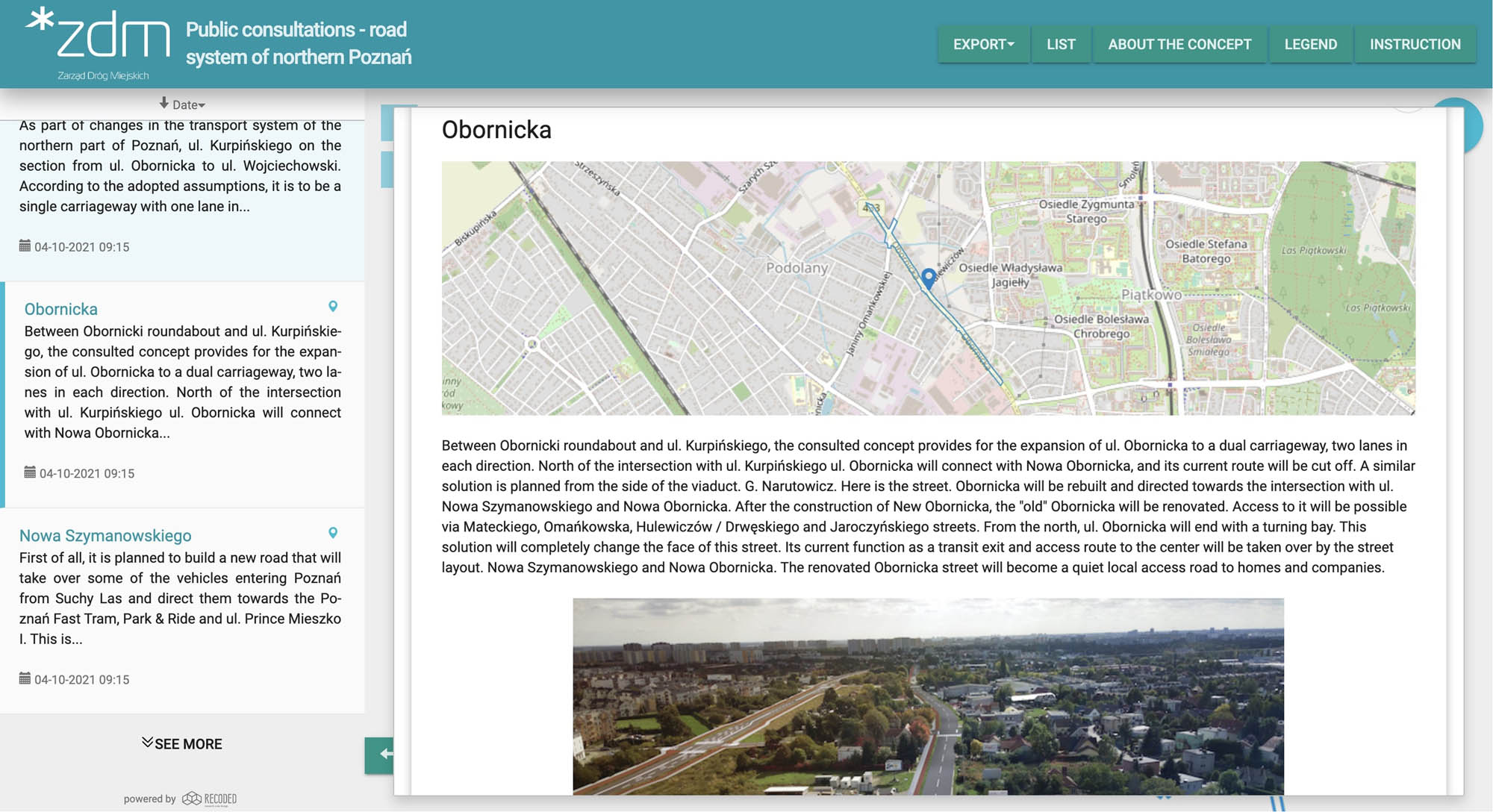
Geodiscussion – used in public consultations – road system of Northern Poznan.
Geodiscussion can also be applied in situations where consultation participants present their proposals and submit them for discussion to other interested parties (Figure 3). In this model, it is the consultation participant who creates a selected object on the map (a point, line, or polygon), adds the content of the statement, and may assign one of the available categories to the statement. Then, other consultation participants can respond to the statement, by commenting on it or rating it on a scale of 1–5. The way geodiscussion is used depends entirely on the configuration, which can be adjusted in the administrative panel. Administrators of geodiscussion have very broad possibilities and can freely manage the communication process, determine the type of data they want to acquire, and manage discussion threads during consultations. They also have tools at their disposal for moderating discussions and analyzing collected data.

Geodiscussion – public consultations on the public transport system in Lodz.
2 Administrative panel of geodiscussion
A key objective within the “Geoportal Supporting Public Participation in Spatial Planning” project was to design the geodiscussion tool to be user-friendly for independent utilization by staff in institutions engaged in public consultations. A very important aspect was the creation of the geodiscussion administrative panel, which would meet the expectations of future users regarding the management of the public consultation process in such a way that the user could independently launch the consultation process in a short time without the need for changes in the application code. The prototype version of the administrative panel was based on the standard administrative panel built into the Django framework (https://docs.djangoproject.com/en/4.2/ref/contrib/admin/). This solution was functional but at the same time not very intuitive. The process of configuring geodiscussion was complex and required navigating between different elements of the panel. It was easy to forget about important elements or make basic mistakes that could lead to the application functioning incorrectly.
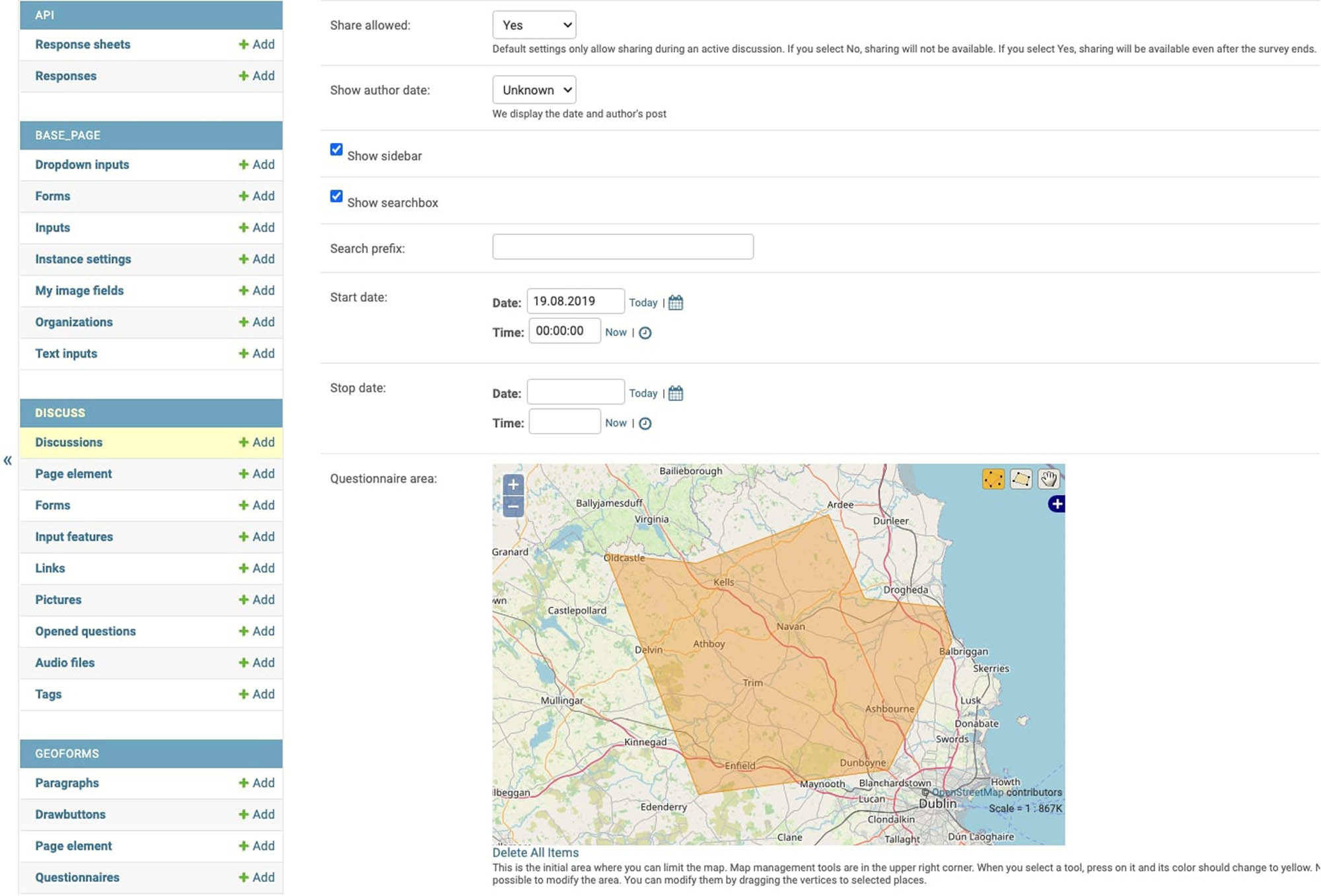
The new version of the administrative panel, which is the subject of the evaluation presented in this article, was designed with the participation of potential users working at the MPU in Poznan. During the development of the panel, four workshop meetings were conducted with three MPU employees. The basis for the work was the panel built-in Django (Figure 4). During the design process, different functionality variants and application interface layouts were consulted. The work was carried out iteratively. Solutions were presented in the form of application sketches built into the free Pencil application (https://pencil.evolus.vn/). The sketches included outlines of application elements and the desired path the user would follow during configuration. Finally, a user interface consisting of five steps was designed and implemented (Figure 5).
General information, the administrator must define the name of the consultation process and the start and end time of the consultation.
Map configuration, the administrator determines the scope of the study and the map zoom level to be shown to the participants of the consultations. It is possible to add a scope from a GeoJSON file.
Layer settings, the administrator specifies which map layers should be available to the participants. It is possible to set a layer that should be launched by default at the start and to arrange the order of the layers in the panel for changing map layers. At this stage, it is possible to add layers from external sources such as MapBox, BingMaps, or TileCache. The default map available in geodiscussion is OpenStreetMap.
Discussion, the administrator defines the form through which consultation participants express their opinions. Text fields and their names can be defined, and categories of statements can be created for participants to choose from. Additionally, there is an option to add an image field, allowing participants to add any graphics to the discussion thread. It is also possible to define the type of geographic object (line, point, polygon) that consultation participants will use to mark selected places on the map.
Summary, at this stage, the administrator can set:
A welcome text and add graphics.
Set the discussion mode as open, or available only to logged-in participants.
Specify whether participants can add new discussion threads or only respond to existing threads.
Enable features allowing voting on a scale of 1–5, giving the option to like or dislike, the ability to share a specific thread on social media, and the requirement for a moderator to approve a new thread.
Administrators can define any statuses for discussion threads.
Configure the appearance of geographic objects by changing the color of the outline, fill color, and line thickness.
The original version of the geodiscussion administrative panel created using Django dashboard.

Administrative panel of the new version of geodiscussion with five steps (top bar) constituting the workflow of geodiscussion.
Progressing from one step to the next necessitates the completion of all mandatory parameters. The sequential configuration approach is anticipated to reduce the likelihood of errors. The geodiscussion administrative panel interface is purposefully crafted to lead users through each step, ensuring a step-by-step guidance. Validation of parameters at each stage restricts further advancement until all essential settings are clearly defined.
3 Research participants and workshops
To define who the potential users of the application are, a research method called Persona [26] was used. This method has already been used in projects aimed at building PPGIS applications [6,27]. It is commonly used in IT, sales, and marketing projects. Personas (sometimes called fictional clients or user or client profiles) are used to better understand and characterize the target customer group. A Persona is a fictional yet intricately detailed portrayal of a “typical user,” embodying specific market segments. This composite representation encompasses demographic characteristics, behaviors, objections, and barriers. However, its primary focus lies in articulating the goals, needs, and preferences pertinent to the product under development.
Drawing from interviews with staff members from MPU Poznan, MPU Lodz, the Mayor’s Office in Poznan, and the Municipal Roads Authority in Poznan, we formulated a Persona tailored to the administrative panel users of geodiscussion. This was Marta, a 35-year-old woman living in a provincial city and working in the structures of local government administration. Actively involved in diverse social projects, Marta’s official responsibilities include supporting decision-makers through the preparation of comprehensive reports and studies on the current situation and residents’ needs. Eager to explore and employ modern tools in her professional capacity, Marta has actively participated in public consultations. Her firsthand experience has cultivated a keen understanding of the imperative to engage a broad spectrum of residents in decision-making processes.
4 Research methods
All activities related to the development of geodiscussion were conducted by following the principles of User-Centered Design (UCD). It is a set of principles and practices aimed at designing computerized systems with a focus on and involvement of users [28]. UCD has been successfully used to build web-based mapping software [29]. UCD focuses on the needs, expectations, and preferences of users when creating products or services. UCD is based on the assumption that designers should thoroughly analyze and understand users and their context to provide effective and useful solutions. The UCD process includes several stages, such as user research, task analysis, creating personas and user scenarios, prototyping, testing, and iterative improvement of the project based on user feedback and information. Creating and developing an online PPGIS using UCD involves continuous usability testing of the designed solutions [20].
During the usability studies of the geodiscussion administrative panel, two well-known methods used in the usability studies of online PPGIS systems [21] were utilized. The non-invasive method based on the analysis of logs and sequences performed by study participants [6] was used. Study participants had specific tasks to perform; using the keyboard and mouse, they activated specific functions in the geodiscussion administrative panel, and each interaction with the panel was recorded in the database. Information about navigation paths, time spent on a specific page, as well as errors were recorded. Log analysis facilitated comprehension of the study participants’ interactions without direct engagement, revealing the most frequently used functions, potential challenges, and the specific steps necessitating corrections. A crucial feature of this method is its non-invasiveness, ensuring that users are not subjected to direct observation, thereby promoting more natural and undisturbed results.
The second method employed in usability studies involved in-depth interviews [30]. Personal conversations were conducted with users of the geodiscussion administrative panel. The interviews served to gain more detailed information about experiences, needs, challenges, and opinions that could not be collected using the non-invasive method. The structure of the interview was closely related to the task that the study participant had to perform. Questions were asked about specific tasks, problems encountered while using the tool, and suggestions for improvements. Each problem encountered by the user was explained and noted as a potential contribution to software functionality changes. This method is much more time-consuming and limited in the sense that only some of the people invited to the interview agree to participate.
5 Data for the usability study of the geodiscussion panel
In 2017, PPGIS researchers at Adam Mickiewicz University organized workshops for public administration employees titled “Internet Tools in Public Consultations.” 68 people participated. The workshops aimed to demonstrate how the geodiscussion application works and allowed participants to configure the consultation process themselves. Participants included representatives from several public administration units, including the MPU in Poznan, Gorzow Wielkopolski, and Szczecin, the Municipal Greenery Board in Krakow, and the City Hall in Poznan, Kolobrzeg, Murowana Goslina, Kornik, Wronki, Bystrzyca Klodzka, Walbrzych, Srem, Gorzow Wielkopolski. Additionally, the workshop participants included representatives of the City Councils in Poznan and Wroclaw, as well as two designers from private planning firms.
Following a concise introduction and tool demonstration by the organizers, participants autonomously undertook the assigned task: configuring geodiscussion for a chosen problem and area. While the task followed a clearly defined sequence and specified requirements for configuring elements at each step, the workshops employed a non-invasive method of usability research [6].
The application used during the workshops incorporated an event logging system that recorded details such as the time taken for each step, errors related to attempts to proceed without configuring required functionalities, the frequency of revisiting previous steps, and the number and nature of changes made after returning to a previous step [21,31]. These logs were stored in the database and linked to individual browser sessions, ensuring complete anonymity for the collected data.
6 Log analysis
Log analysis showed that none of the workshop participants had problems completing the entire user path, and all of them successfully configured geodiscussion. The longest configuration took 65 min and 9 s, while the fastest was done in 22 min and 2 s, with a standard deviation of 11 min and 36 s (Figure 6). Among the 41 workshop participants, the logs did not record any errors associated with attempts to proceed without configuring the required functionalities. The average number of changes made in the configuration was 15, most often performed in the fifth and fourth steps. The most frequently changed parameters were related to the configuration of the discussion mode: discussions with the possibility of adding new objects or discussions based on commenting and rating the existing objects.
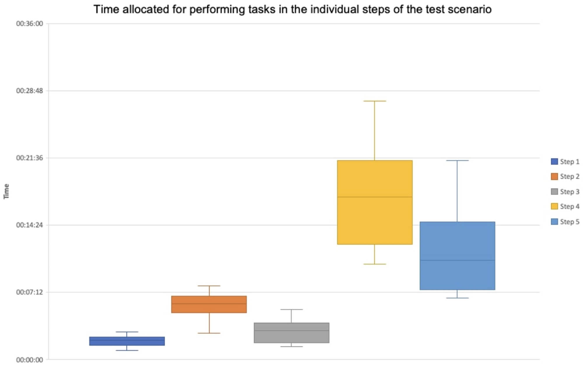
Time allocated for performing tasks in the individual steps of the test scenario.
The majority of errors, 25 in total, occurred in the initial step, which required participants to set the title of the consultation, along with the designated start and end times. Users commonly overlooked the parameter related to the end time of the consultation. The average time needed for this step was 1 min and 59 s, with a standard deviation of 33 s. None of the study participants returned to the first step and made no modifications at this stage.
The subsequent step that presented challenges was the second one, where users were required to delineate the scope of the consultation study on the map. In this instance, the polygon creation function proved to be the source of the most difficulties. Study participants who had problems with this step created a polygon but did not confirm it by double-clicking the last point, leaving the object on the map in edit mode. On average, study participants spent 5 min and 54 s on this step, with a standard deviation of 1 min and 7 s. After fully configuring geodiscussion, 16 people returned to this step and modified the scope of the consultation.
In the case of the third step, which involved configuring map layers, the average task completion time was 3 min and 1 s, with the standard deviation of 1 min and 24 s. No one made a configuration error, while 37 study participants returned to this step and made modifications concerning the order of displaying map layers and the default layer available to consultation participants.
Step 4, dedicated to the creation of the geodiscussion form, proved to be the most time-consuming phase of the study. Participants, on average, spent 17 min and 3 s on this step, with a standard deviation of 4 min and 50 s. The most time-consuming aspect was configuring the set of categories for the discussion thread, averaging 6 min and 12 s.
The second most time-consuming element was defining text fields and setting them in the correct order, which took users an average of 4 min and 26 s. The most frequently changed element in this step was the configuration concerning the types of geographical objects (line, point, polygon) that could be used to mark places on the map.
Step 5, setting the discussion mode, configuring permissions, and statuses, took an average of 11 min and 14 s, with the standard deviation of 3 min and 50 s. At this stage, study participants had the most freedom. This was the last step in the configuration, and the task content involved one of many possible configurations. Study participants were tasked with creating a geodiscussion where anyone could add any object to the map and add a discussion thread. Other participants were to have the opportunity to comment on discussion threads and rate them on the scale of 1–5. Furthermore, participants were given the option to choose whether drawn objects, presented as polygons on the map, should be displayed as centroids, with the added feature of revealing the actual object upon hovering.
All study participants returned to this step and made changes. These were configuration changes related to discussion modes.
They examined the functionality of the discussion, exploring scenarios where participants could only comment on existing objects. Additionally, they assessed how the available options expanded the discussion capabilities, introducing features such as rating or liking discussion threads and comments.
7 Direct interviews
During the workshops, 11 participants (16% of all workshop participants) agreed to participate in direct interviews as part of an in-depth usability study of the administrative panel and verification of functional needs. The interviews were directly related to the scenario of the task performed by the workshop participants. During the conversation, each step of the task used during the workshops was discussed in detail. Additionally, the interviewees were asked to rate the difficulty level of each task on the scale of 1–5 (where 1 represents the lowest difficulty level and 5 the highest), to specify whether the task was understandable with a Yes or No answer (Table 1), and to provide suggestions for potential modifications to the functionalities. At the same time, each interview participant was asked to indicate ideas for new functionalities or propose changes to the existing functionalities.
Difficulty level of tasks and information in understanding the content of tasks performed by users of the geodiscussion administrative panel
| LP | Step 1 | Step 2 | Step 3 | Step 4 | Step 5 | |||||
|---|---|---|---|---|---|---|---|---|---|---|
| Difficulty level | Task understandable level | Difficulty level | Task understandable level | Difficulty level | Task understandable level | Difficulty level | Task understandable level | Difficulty level | Task understandable level | |
| 1 | 1 | 1 | 2 | 1 | 2 | 1 | 2 | 1 | 4 | 0 |
| 2 | 1 | 1 | 2 | 1 | 2 | 1 | 3 | 0 | 3 | 1 |
| 3 | 1 | 1 | 3 | 0 | 2 | 1 | 2 | 1 | 3 | 1 |
| 4 | 1 | 1 | 3 | 1 | 3 | 0 | 2 | 1 | 2 | 1 |
| 5 | 1 | 1 | 2 | 1 | 3 | 1 | 1 | 1 | 4 | 0 |
| 6 | 1 | 1 | 1 | 1 | 4 | 0 | 4 | 0 | 5 | 0 |
| 7 | 2 | 1 | 3 | 1 | 2 | 1 | 1 | 1 | 2 | 1 |
| 8 | 1 | 1 | 1 | 1 | 1 | 1 | 3 | 1 | 3 | 1 |
| 9 | 2 | 1 | 2 | 1 | 2 | 1 | 1 | 1 | 2 | 1 |
| 10 | 1 | 1 | 1 | 1 | 1 | 1 | 2 | 1 | 1 | 1 |
| 11 | 1 | 1 | 2 | 1 | 2 | 1 | 1 | 1 | 1 | 1 |
| Average | 1.2 | 1.0 | 2.0 | 0.9 | 2.2 | 0.8 | 2.0 | 0.8 | 2,7 | 0.7 |
| Median | 1 | 1 | 2 | 1 | 2 | 1 | 2 | 1 | 3 | 1 |
Conducting direct usability testing through interviews proved instrumental in gaining deeper insights into the challenges associated with certain tasks. It became evident that clarifications and improvements were needed for the descriptions of various functionalities within the geodiscussion administrative panel.
During Step 2, where participants were required to delineate the consultation’s scope on the map using a polygon, seven individuals encountered difficulties. To address this, the suggestion of displaying an additional description near the mouse cursor, providing guidance on completing the drawing, was identified as a beneficial solution.
In Step 3, where the task involved adding a map layer and specifying the default display layer, naming issues led to challenges. Four participants noted a lack of clear information regarding the workings of “base layers” and “additional layers,” particularly since these individuals had no prior experience with GIS applications.
Step 4, focused on creating a form for entering discussion threads, generally proceeded without major issues. However, two participants initially found the task content unclear, necessitating additional time for independent testing of various parameters to complete the step properly.
The most intricate task emerged in Step 5, where participants defined geodiscussion’s operational mode and available options. Three participants found the task content unclear, and six individuals rated the difficulty level as 3 or higher. This configuration stage offered diverse settings, highlighting the need to better group parameters visually and enclose them within blocks with appropriate naming, as revealed through direct usability testing in the interviews.
All 11 participants in the in-depth usability study provided positive evaluations for the entire geodiscussion configuration process, attributing it to the implemented navigation method that guides users systematically through the administrative panel. The developed validation mechanism, which alerts users to potential deficiencies, was widely recognized as clear and understandable.
Out of the 11 interview participants, 9 expressed confidence that, without formal training, they could independently configure geodiscussion within a reasonable timeframe. The remaining two individuals suggested that basic knowledge of GIS systems is essential for correctly preparing a consultation using geodiscussion. They specifically highlighted that the steps involving defining the scope and configuring map layers could pose challenges for individuals unfamiliar with more advanced mapping applications beyond Google Maps. This is particularly important as the lack of awareness among decision-makers regarding the capabilities offered by GIS is identified as one of the main limitations in the adoption of PPGIS in public consultations [32].
8 Summary and recommendations
The research on the geodiscussion administrative panel, as presented in this article, forms an integral part of the broader initiative to develop and promote PPGIS tools. The workshops conducted in this study offered valuable insights into the capability of target users, who engage in public consultations as part of their professional responsibilities, to autonomously configure and initiate the consultation process using interactive maps.
The workshop invitations indicated that a brief training session would enable participants to independently conduct consultations without undergoing demanding training or acquiring specialized knowledge was the primary expectation of the workshop participants. This was confirmed in the interviews with workshop participants. First, they wanted to see what geodiscussion is and whether they could actually use this tool independently in their work.
Using usability metrics defined by Nielsen [22], we proceeded to assess the usability of the geodiscussion administrative panel. Starting with efficiency, the study revealed that the usability of the geodiscussion administrative panel is high. The process of launching geodiscussion, which includes creating public consultations and providing immediate access to results in the form of maps, tables, and charts, was described by study participants as intuitive and well-designed. Learnability, defined as the ease of use during the first encounter, was notably high. All study participants completed the tasks assigned to them. Over 80% of interviewees stated they could configure the consultation process independently without the need for training. The remaining participants indicated that knowledge of GIS might be helpful for configuration. However, no one described the use of the geodiscussion administrative panel as difficult.
Another usability metric of the geodiscussion administrative panel, after learnability, is the low number of errors made during the tasks prepared for the workshop participants. The tasks aimed to test all possible functionalities. Most errors were made on a seemingly simple task involving setting the consultation end time. Evidently, the operation of this functionality was poorly designed, which was corrected in a subsequent version of the application. No critical errors were detected during the study that would prevent workshop participants from fully configuring the consultation process.
Since these were one-time workshops, it was not possible to assess another usability metric, memorability. We can only rely on the declarations of the workshop participants, who claimed they could navigate the administrative panel configuration process independently without training. The panel was designed to guide the user step–by–step, with a minimal number of available functionalities at each step, along with detailed validation of each user action. The step-by-step user guidance mechanism may result in a longer configuration process and does not allow skipping certain less needed functions for some users. At the same time, it can be stated that the impact of memorability as a usability metric has thus been minimized.
Satisfaction level is the last of the five usability metrics proposed by Nielsen [22]. Despite certain imperfections, the geodiscussion administrative panel did not pose significant configuration challenges. Every workshop participant successfully prepared the consultation process independently. No participant expressed dissatisfaction with the functionality and capabilities of the geodiscussion administrative panel. Furthermore, the workshop participants were eager to share their insights on the potential applications of geodiscussion in various processes, including local spatial development plans, revitalization programs, development concepts, diagnostics of space and living conditions, participatory budgets, transport plans, and residents’ mobility [25]. This wide array of activities within public space management suggests that local government employees involved in these processes possess varied competencies and skills in using Internet tools. While catering to such a diverse user base presents challenges for creators of tools like geodiscussion, it also opens up substantial opportunities for research and implementation activities in the realm of PPGIS.
The authors of the article acknowledge the limitations inherent in the applied usability research methods. The structured tasks within the organized workshops, constrained by limited time, create an environment that may differ significantly from the typical working conditions of administrative panel users. This variation could potentially induce pressure and haste among certain study participants. Additionally, it is worth noting that workshop participants, by definition, are individuals eager to learn about new technologies.
It is important to recognize that the results might vary if individuals involved in public participation within their respective institutions and companies were randomly selected for the studies. However, the authors contend that, in their opinion, the test users adequately represent the potential users of the geodiscussion administrative panel. The results show that all participants completed the assigned tasks, and moreover, the majority of those interviewed stated they could have done so without training. It would be beneficial to verify if this would indeed occur when each person performed the task independently, without prior training, during their regular work duties. This verification is particularly important because the opinion reflects only 9 out of the 11 individuals who agreed to interviews, not the views of all 68 workshop participants.
The research outlined in this article unfolded within a broader project, where one of the primary objectives was to fashion a geodiscussion tool adaptable for diverse participatory processes. The authors of this article also played a pivotal role as co-creators of the tool, and its development persisted concurrently with the research project. The findings notably influenced the implementation of specific enhancements in the geodiscussion administrative panel, particularly in the areas of navigation, the tag and status creation module, and homepage configuration.
The ongoing evolution of IT tools aimed at supporting participatory decision-making, exemplified by geodiscussion, mandates continual investigation into the needs and behaviors of users. Active involvement is imperative not only from the creators and administrators of public consultations but also from the users who actively engage in these consultations. Looking forward, the authors envision a scenario where geodiscussion could be distributed through the SaaS model. This model would empower consultation creators to independently establish accounts, configure the consultation process, analyze data, and ultimately present results. Such a distribution model holds the potential to streamline the popularization of PPGIS as a method for public consultation.
However, within the rapidly evolving technological landscape, maintaining the application at an optimal functional and technical level necessitates a dedicated team for ongoing maintenance and development. Exploring the conditions and mechanisms necessary for PPGIS tools to dynamically keep pace with information technology’s evolution stands as a distinct issue that warrants careful consideration in the near future. When selecting technologies, it would be advisable to focus on whether they are mature programming solutions with support and a large user base. Such conditions increase the chances that the developed PPGIS solution can be maintained and further developed without requiring significant investments. Another worthwhile consideration is releasing the source code of the tool under an Open Source license and building a community of software developers around the project. In conclusion, it is crucial to remember that it is very easy to succumb to the temptation of adding new functionalities that may appear very useful or even essential in PPGIS tools. However, each new functionality will impact the tool’s usability and the difficulty of its operation. First and foremost, one must consider who will be using the tool and what skills they possess. We fully agree that one of the best approaches to creating and developing PPGIS tools is a UCD.
Acknowledgements
The research described in this article was conducted as part of two projects: An Experimental Study of Public Participation in Planning Decision Making Using Web-based GIS, funded by the National Science Center in Poland; the funding decision DEC-2012/05/B/HS4/03850. Geoportal supporting public participation in urban planning financed by the National Center for Research and Development (contract number PBS3/A9/39/2015).
-
Author contributions: Piotr Jankowski: conceptualization, writing-reviewing and editing, and research supervision. Marek Młodkowski: methodology, writing-original draft preparation, conducting usability study, preparation of results, and designing geodiscussion.
-
Conflict of interest: Prof. Jankowski, the article’s co-author, serves as the Editor-in-Chief of Open Geosciences. He was not involved in the peer review process and did not have any role in the final acceptance decision.
References
[1] Bąkowska-Waldmann E, Brudka C, Jankowski P. Legal and organizational framework for the use of geoweb methods for public participation in spatial planning in Poland: Experiences, opinions and challenges. Quaest Geogr. 2018;37:163–75. 10.2478/quageo-2018-0032.Search in Google Scholar
[2] Jankowski P, Czepkiewicz M, Zwoliński Z, Kaczmarek T, Młodkowski M, Bąkowska-Waldmann E, et al. Geoweb methods for public participation in urban planning: selected cases from Poland. In: Koutsopoulos K, de Miguel González R, Donert K, editors. Geospatial Challenges in the 21st Century. Cham, Switzerland: Springer Nature; 2019. p. 249–69.Search in Google Scholar
[3] Bąkowska E. Zastosowanie metody projektu wykorzystującej narzędzia PPGIS w procesie kształcenia na kierunku gospodarka przestrzenna. Biuletyn KPZK PAN. 2016;260:146–58.Search in Google Scholar
[4] Jankowski P, Czepkiewicz M, Młodkowski M, Zwoliński Z. Geo‐questionnaire: A method and tool for public preference elicitation in land use planning. Trans GIS. 2016;20:903–24. 10.1111/tgis.12191.Search in Google Scholar
[5] Innes JE, Booher DE. Reframing public participation: strategies for the 21st century. Plan Theory Pract. 2004;5:419–36. 10.1080/1464935042000293170.Search in Google Scholar
[6] Nyerges T, Aguirre RW. Public participation in analytic-deliberative decision making: evaluating a large-group online field experiment. Ann Assoc Am Geogr. 2011;101:561–86. 10.1080/00045608.2011.563669.Search in Google Scholar
[7] Sieber R. Public participation geographic information systems: a literature review and framework. Ann Assoc Am Geogr. 2006;96:491–507. 10.1111/j.1467-8306.2006.00702.x.Search in Google Scholar
[8] Goodchild MF. Citizens as sensors: the world of volunteered geography. GeoJournal. 2007;69:211–21. 10.1007/s10708-007-9111-y.Search in Google Scholar
[9] Jankowski P, Kaczmarek T, Zwoliński Zb, Bąkowska-Waldmann E, Brudka C, Czepkiewicz M, et al. Zastosowanie aplikacji geoankiety i geodyskusji w partycypacyjnym planowaniu przestrzennym – dobre praktyki. Biblioteka Aglomeracji Poznańskiej. 2018;32:7–81.Search in Google Scholar
[10] Brown G, Raymond CM. Methods for identifying land use conflict potential using participatory mapping. Landsc Urban Plan. 2014;122:196–208. 10.1016/j.landurbplan.2013.11.007.Search in Google Scholar
[11] Eveliina H, Pilvi N. Beyond the blind spot: enhancing polyphony through city planning activism using public participation GIS. Urban Plan. 2023 Nov 15;9(1):1848–75.Search in Google Scholar
[12] Kahila-Tani M, Kytta M, Geertman S. Does mapping improve public participation? Exploring the pros and cons of using public participation GIS in urban planning practices. Landsc Urban Plan. 2019;186:45–55. 10.1016/j.landurbplan.2019.02.019.Search in Google Scholar
[13] Czepkiewicz M, Jankowski P, Młodkowski M. Geo-questionnaires in urban planning: recruitment methods, participant engagement, and data quality. Cartogr Geogr Inf Sci. 2016;44:551–67. 10.1080/15230406.2016.1230520.Search in Google Scholar
[14] Jankowski P, Kaczmarek T. Participatory methods in urban planning. Editorial. Polit Reg i Rozwój Regionalny. 2017;35:5–7.Search in Google Scholar
[15] Jankowski P, Czepkiewicz M, Młodkowski M, Zwoliński Z, Wójcicki M. Evaluating the scalability of public participation in urban land use planning: A comparison of Geoweb methods with face-to-face meetings. Environ Plan B: Urban Anal City Sci. 2017;46:511–33. 10.1177/2399808317719709.Search in Google Scholar
[16] Kingston R. Online public participation GIS for spatial planning. In: Nyerges T, Couclelis H, McMaster R, editors. The SAGE Handbook of GIS and Society. London: SAGE Publications; 2011. p. 361–80.Search in Google Scholar
[17] Babelon I, Pánek J, Falco E, Kleinhans R, Charlton J. Between consultation and collaboration: self-reported objectives for 25 web-based geoparticipation projects in urban planning. ISPRS Int J Geo-Inf. 2021;10:783. 10.3390/ijgi10110783. Search in Google Scholar
[18] Jankowski P. Designing participatory geographic information systems. In: Nyerges TL, Couclelis H, McMaster R, editors. The SAGE Handbook of GIS and Society. London: SAGE Publications; 2011. p. 347–60.Search in Google Scholar
[19] Ganapati S. Using geographic information systems to increase citizen engagement. IBM Center for the business of government. Public Adm Rev. 2010;3:425–34.Search in Google Scholar
[20] Mlodkowski M, Walczak D, Jankowski P. User-centered design and agile programming methods in the process of creating a geoportal supporting public participation in urban planning. Roczniki Geomatyki. 2016;XIV(75):597–608.Search in Google Scholar
[21] Haklay M, Tobón C. Usability evaluation and PPGIS: towards a user-centred design approach. Int J Geogr Inf Sci. 2003 Sep;17(6):577–92. 10.1080/1365881031000114107.Search in Google Scholar
[22] Nielsen J. Usability 101: Introduction to usability [Internet]. Nielsen Norman Group; 2012. https://www.nngroup.com/articles/usability-101-introduction-to-usability/.Search in Google Scholar
[23] Degrossi LC, Porto de Albuquerque J, Santos Rocha R, dos, Zipf A. A taxonomy of quality assessment methods for volunteered and crowdsourced geographic information. Trans GIS. 2018;22:542–60. 10.1111/tgis.12329.Search in Google Scholar
[24] Fagerholm N, Raymond CM, Olafsson AS, Brown G, Rinne T, Hasanzadeh K, et al. A methodological framework for analysis of participatory mapping data in research, planning, and management. Int J Geogr Inf Sci. 2021;35(9):1848–75. 10.1080/13658816.2020.1869747. Search in Google Scholar
[25] Bąkowska-Waldmann E, Kaczmarek T. The use of PPGIS: towards reaching a meaningful public participation in spatial planning. ISPRS Int J Geo-Inf. 2021;10:581. 10.3390/ijgi10090581. Search in Google Scholar
[26] Nyerges TL, Ramsey KS, Wilson MW. Design considerations for an internet portal to support public participation in transportation improvement decision making. In Collaborative Geographic Information Systems; 2006. p. 208–36. 10.4018/978-1-59140-845-1.ch012.Search in Google Scholar
[27] Butt MA, Li S. UML-based requirement modeling of Web online synchronous collaborative public participatory GIS. Appl Geomat. 2015;7:203–42. 10.1007/s12518-015-0154-3.Search in Google Scholar
[28] Abras C, Maloney-Krichmar D, Preece J. User-Centered Design. In: Bainbridge W, editor. Encyclopedia of Human-Computer Interaction. Thousand Oaks, CA: Sage Publications; 2004. p. 445–56.Search in Google Scholar
[29] Nivala A-M, Brewster S, Sarjakoski TL. Usability evaluation of web mapping sites. The Cartographic Journal. 45, 2008. p. 129–38. 10.1179/174327708x305120.Search in Google Scholar
[30] Zhao J, Coleman DJ. An empirical assessment of a web-based PPGIS prototype. Proceedings of the 45th Annual Conference of the Urban and Regional Information Systems Association. IL, USA: Citeseer: Park Ridge; 2007 Apr.Search in Google Scholar
[31] Swobodzinski M, Jankowski P. Understanding user interaction patterns within online systems for public-participation transportation planning. Trans GIS. 2014 Jun;18(3):401–20.Search in Google Scholar
[32] Aranda NR, De Waegemaeker J, Van de Weghe N. The evolution of public participation GIS (PPGIS) barriers in spatial planning practice. Appl Geogr. 2023 Jun;155:102940.Search in Google Scholar
© 2024 the author(s), published by De Gruyter
This work is licensed under the Creative Commons Attribution 4.0 International License.
Articles in the same Issue
- Regular Articles
- Theoretical magnetotelluric response of stratiform earth consisting of alternative homogeneous and transitional layers
- The research of common drought indexes for the application to the drought monitoring in the region of Jin Sha river
- Evolutionary game analysis of government, businesses, and consumers in high-standard farmland low-carbon construction
- On the use of low-frequency passive seismic as a direct hydrocarbon indicator: A case study at Banyubang oil field, Indonesia
- Water transportation planning in connection with extreme weather conditions; case study – Port of Novi Sad, Serbia
- Zircon U–Pb ages of the Paleozoic volcaniclastic strata in the Junggar Basin, NW China
- Monitoring of mangrove forests vegetation based on optical versus microwave data: A case study western coast of Saudi Arabia
- Microfacies analysis of marine shale: A case study of the shales of the Wufeng–Longmaxi formation in the western Chongqing, Sichuan Basin, China
- Multisource remote sensing image fusion processing in plateau seismic region feature information extraction and application analysis – An example of the Menyuan Ms6.9 earthquake on January 8, 2022
- Identification of magnetic mineralogy and paleo-flow direction of the Miocene-quaternary volcanic products in the north of Lake Van, Eastern Turkey
- Impact of fully rotating steel casing bored pile on adjacent tunnels
- Adolescents’ consumption intentions toward leisure tourism in high-risk leisure environments in riverine areas
- Petrogenesis of Jurassic granitic rocks in South China Block: Implications for events related to subduction of Paleo-Pacific plate
- Differences in urban daytime and night block vitality based on mobile phone signaling data: A case study of Kunming’s urban district
- Random forest and artificial neural network-based tsunami forests classification using data fusion of Sentinel-2 and Airbus Vision-1 satellites: A case study of Garhi Chandan, Pakistan
- Integrated geophysical approach for detection and size-geometry characterization of a multiscale karst system in carbonate units, semiarid Brazil
- Spatial and temporal changes in ecosystem services value and analysis of driving factors in the Yangtze River Delta Region
- Deep fault sliding rates for Ka-Ping block of Xinjiang based on repeating earthquakes
- Improved deep learning segmentation of outdoor point clouds with different sampling strategies and using intensities
- Platform margin belt structure and sedimentation characteristics of Changxing Formation reefs on both sides of the Kaijiang-Liangping trough, eastern Sichuan Basin, China
- Enhancing attapulgite and cement-modified loess for effective landfill lining: A study on seepage prevention and Cu/Pb ion adsorption
- Flood risk assessment, a case study in an arid environment of Southeast Morocco
- Lower limits of physical properties and classification evaluation criteria of the tight reservoir in the Ahe Formation in the Dibei Area of the Kuqa depression
- Evaluation of Viaducts’ contribution to road network accessibility in the Yunnan–Guizhou area based on the node deletion method
- Permian tectonic switch of the southern Central Asian Orogenic Belt: Constraints from magmatism in the southern Alxa region, NW China
- Element geochemical differences in lower Cambrian black shales with hydrothermal sedimentation in the Yangtze block, South China
- Three-dimensional finite-memory quasi-Newton inversion of the magnetotelluric based on unstructured grids
- Obliquity-paced summer monsoon from the Shilou red clay section on the eastern Chinese Loess Plateau
- Classification and logging identification of reservoir space near the upper Ordovician pinch-out line in Tahe Oilfield
- Ultra-deep channel sand body target recognition method based on improved deep learning under UAV cluster
- New formula to determine flyrock distance on sedimentary rocks with low strength
- Assessing the ecological security of tourism in Northeast China
- Effective reservoir identification and sweet spot prediction in Chang 8 Member tight oil reservoirs in Huanjiang area, Ordos Basin
- Detecting heterogeneity of spatial accessibility to sports facilities for adolescents at fine scale: A case study in Changsha, China
- Effects of freeze–thaw cycles on soil nutrients by soft rock and sand remodeling
- Vibration prediction with a method based on the absorption property of blast-induced seismic waves: A case study
- A new look at the geodynamic development of the Ediacaran–early Cambrian forearc basalts of the Tannuola-Khamsara Island Arc (Central Asia, Russia): Conclusions from geological, geochemical, and Nd-isotope data
- Spatio-temporal analysis of the driving factors of urban land use expansion in China: A study of the Yangtze River Delta region
- Selection of Euler deconvolution solutions using the enhanced horizontal gradient and stable vertical differentiation
- Phase change of the Ordovician hydrocarbon in the Tarim Basin: A case study from the Halahatang–Shunbei area
- Using interpretative structure model and analytical network process for optimum site selection of airport locations in Delta Egypt
- Geochemistry of magnetite from Fe-skarn deposits along the central Loei Fold Belt, Thailand
- Functional typology of settlements in the Srem region, Serbia
- Hunger Games Search for the elucidation of gravity anomalies with application to geothermal energy investigations and volcanic activity studies
- Addressing incomplete tile phenomena in image tiling: Introducing the grid six-intersection model
- Evaluation and control model for resilience of water resource building system based on fuzzy comprehensive evaluation method and its application
- MIF and AHP methods for delineation of groundwater potential zones using remote sensing and GIS techniques in Tirunelveli, Tenkasi District, India
- New database for the estimation of dynamic coefficient of friction of snow
- Measuring urban growth dynamics: A study in Hue city, Vietnam
- Comparative models of support-vector machine, multilayer perceptron, and decision tree predication approaches for landslide susceptibility analysis
- Experimental study on the influence of clay content on the shear strength of silty soil and mechanism analysis
- Geosite assessment as a contribution to the sustainable development of Babušnica, Serbia
- Using fuzzy analytical hierarchy process for road transportation services management based on remote sensing and GIS technology
- Accumulation mechanism of multi-type unconventional oil and gas reservoirs in Northern China: Taking Hari Sag of the Yin’e Basin as an example
- TOC prediction of source rocks based on the convolutional neural network and logging curves – A case study of Pinghu Formation in Xihu Sag
- A method for fast detection of wind farms from remote sensing images using deep learning and geospatial analysis
- Spatial distribution and driving factors of karst rocky desertification in Southwest China based on GIS and geodetector
- Physicochemical and mineralogical composition studies of clays from Share and Tshonga areas, Northern Bida Basin, Nigeria: Implications for Geophagia
- Geochemical sedimentary records of eutrophication and environmental change in Chaohu Lake, East China
- Research progress of freeze–thaw rock using bibliometric analysis
- Mixed irrigation affects the composition and diversity of the soil bacterial community
- Examining the swelling potential of cohesive soils with high plasticity according to their index properties using GIS
- Geological genesis and identification of high-porosity and low-permeability sandstones in the Cretaceous Bashkirchik Formation, northern Tarim Basin
- Usability of PPGIS tools exemplified by geodiscussion – a tool for public participation in shaping public space
- Efficient development technology of Upper Paleozoic Lower Shihezi tight sandstone gas reservoir in northeastern Ordos Basin
- Assessment of soil resources of agricultural landscapes in Turkestan region of the Republic of Kazakhstan based on agrochemical indexes
- Evaluating the impact of DEM interpolation algorithms on relief index for soil resource management
- Petrogenetic relationship between plutonic and subvolcanic rocks in the Jurassic Shuikoushan complex, South China
- A novel workflow for shale lithology identification – A case study in the Gulong Depression, Songliao Basin, China
- Characteristics and main controlling factors of dolomite reservoirs in Fei-3 Member of Feixianguan Formation of Lower Triassic, Puguang area
- Impact of high-speed railway network on county-level accessibility and economic linkage in Jiangxi Province, China: A spatio-temporal data analysis
- Estimation model of wild fractional vegetation cover based on RGB vegetation index and its application
- Lithofacies, petrography, and geochemistry of the Lamphun oceanic plate stratigraphy: As a record of the subduction history of Paleo-Tethys in Chiang Mai-Chiang Rai Suture Zone of Thailand
- Structural features and tectonic activity of the Weihe Fault, central China
- Application of the wavelet transform and Hilbert–Huang transform in stratigraphic sequence division of Jurassic Shaximiao Formation in Southwest Sichuan Basin
- Structural detachment influences the shale gas preservation in the Wufeng-Longmaxi Formation, Northern Guizhou Province
- Distribution law of Chang 7 Member tight oil in the western Ordos Basin based on geological, logging and numerical simulation techniques
- Evaluation of alteration in the geothermal province west of Cappadocia, Türkiye: Mineralogical, petrographical, geochemical, and remote sensing data
- Numerical modeling of site response at large strains with simplified nonlinear models: Application to Lotung seismic array
- Quantitative characterization of granite failure intensity under dynamic disturbance from energy standpoint
- Characteristics of debris flow dynamics and prediction of the hazardous area in Bangou Village, Yanqing District, Beijing, China
- Rockfall mapping and susceptibility evaluation based on UAV high-resolution imagery and support vector machine method
- Statistical comparison analysis of different real-time kinematic methods for the development of photogrammetric products: CORS-RTK, CORS-RTK + PPK, RTK-DRTK2, and RTK + DRTK2 + GCP
- Hydrogeological mapping of fracture networks using earth observation data to improve rainfall–runoff modeling in arid mountains, Saudi Arabia
- Petrography and geochemistry of pegmatite and leucogranite of Ntega-Marangara area, Burundi, in relation to rare metal mineralisation
- Prediction of formation fracture pressure based on reinforcement learning and XGBoost
- Hazard zonation for potential earthquake-induced landslide in the eastern East Kunlun fault zone
- Monitoring water infiltration in multiple layers of sandstone coal mining model with cracks using ERT
- Study of the patterns of ice lake variation and the factors influencing these changes in the western Nyingchi area
- Productive conservation at the landslide prone area under the threat of rapid land cover changes
- Sedimentary processes and patterns in deposits corresponding to freshwater lake-facies of hyperpycnal flow – An experimental study based on flume depositional simulations
- Study on time-dependent injectability evaluation of mudstone considering the self-healing effect
- Detection of objects with diverse geometric shapes in GPR images using deep-learning methods
- Behavior of trace metals in sedimentary cores from marine and lacustrine environments in Algeria
- Spatiotemporal variation pattern and spatial coupling relationship between NDVI and LST in Mu Us Sandy Land
- Formation mechanism and oil-bearing properties of gravity flow sand body of Chang 63 sub-member of Yanchang Formation in Huaqing area, Ordos Basin
- Diagenesis of marine-continental transitional shale from the Upper Permian Longtan Formation in southern Sichuan Basin, China
- Vertical high-velocity structures and seismic activity in western Shandong Rise, China: Case study inspired by double-difference seismic tomography
- Spatial coupling relationship between metamorphic core complex and gold deposits: Constraints from geophysical electromagnetics
- Disparities in the geospatial allocation of public facilities from the perspective of living circles
- Research on spatial correlation structure of war heritage based on field theory. A case study of Jinzhai County, China
- Formation mechanisms of Qiaoba-Zhongdu Danxia landforms in southwestern Sichuan Province, China
- Magnetic data interpretation: Implication for structure and hydrocarbon potentiality at Delta Wadi Diit, Southeastern Egypt
- Deeply buried clastic rock diagenesis evolution mechanism of Dongdaohaizi sag in the center of Junggar fault basin, Northwest China
- Application of LS-RAPID to simulate the motion of two contrasting landslides triggered by earthquakes
- The new insight of tectonic setting in Sunda–Banda transition zone using tomography seismic. Case study: 7.1 M deep earthquake 29 August 2023
- The critical role of c and φ in ensuring stability: A study on rockfill dams
- Evidence of late quaternary activity of the Weining-Shuicheng Fault in Guizhou, China
- Extreme hydroclimatic events and response of vegetation in the eastern QTP since 10 ka
- Spatial–temporal effect of sea–land gradient on landscape pattern and ecological risk in the coastal zone: A case study of Dalian City
- Study on the influence mechanism of land use on carbon storage under multiple scenarios: A case study of Wenzhou
- A new method for identifying reservoir fluid properties based on well logging data: A case study from PL block of Bohai Bay Basin, North China
- Comparison between thermal models across the Middle Magdalena Valley, Eastern Cordillera, and Eastern Llanos basins in Colombia
- Mineralogical and elemental analysis of Kazakh coals from three mines: Preliminary insights from mode of occurrence to environmental impacts
- Chlorite-induced porosity evolution in multi-source tight sandstone reservoirs: A case study of the Shaximiao Formation in western Sichuan Basin
- Predicting stability factors for rotational failures in earth slopes and embankments using artificial intelligence techniques
- Origin of Late Cretaceous A-type granitoids in South China: Response to the rollback and retreat of the Paleo-Pacific plate
- Modification of dolomitization on reservoir spaces in reef–shoal complex: A case study of Permian Changxing Formation, Sichuan Basin, SW China
- Geological characteristics of the Daduhe gold belt, western Sichuan, China: Implications for exploration
- Rock physics model for deep coal-bed methane reservoir based on equivalent medium theory: A case study of Carboniferous-Permian in Eastern Ordos Basin
- Enhancing the total-field magnetic anomaly using the normalized source strength
- Shear wave velocity profiling of Riyadh City, Saudi Arabia, utilizing the multi-channel analysis of surface waves method
- Effect of coal facies on pore structure heterogeneity of coal measures: Quantitative characterization and comparative study
- Inversion method of organic matter content of different types of soils in black soil area based on hyperspectral indices
- Detection of seepage zones in artificial levees: A case study at the Körös River, Hungary
- Tight sandstone fluid detection technology based on multi-wave seismic data
- Characteristics and control techniques of soft rock tunnel lining cracks in high geo-stress environments: Case study of Wushaoling tunnel group
- Influence of pore structure characteristics on the Permian Shan-1 reservoir in Longdong, Southwest Ordos Basin, China
- Study on sedimentary model of Shanxi Formation – Lower Shihezi Formation in Da 17 well area of Daniudi gas field, Ordos Basin
- Multi-scenario territorial spatial simulation and dynamic changes: A case study of Jilin Province in China from 1985 to 2030
- Review Articles
- Major ascidian species with negative impacts on bivalve aquaculture: Current knowledge and future research aims
- Prediction and assessment of meteorological drought in southwest China using long short-term memory model
- Communication
- Essential questions in earth and geosciences according to large language models
- Erratum
- Erratum to “Random forest and artificial neural network-based tsunami forests classification using data fusion of Sentinel-2 and Airbus Vision-1 satellites: A case study of Garhi Chandan, Pakistan”
- Special Issue: Natural Resources and Environmental Risks: Towards a Sustainable Future - Part I
- Spatial-temporal and trend analysis of traffic accidents in AP Vojvodina (North Serbia)
- Exploring environmental awareness, knowledge, and safety: A comparative study among students in Montenegro and North Macedonia
- Determinants influencing tourists’ willingness to visit Türkiye – Impact of earthquake hazards on Serbian visitors’ preferences
- Application of remote sensing in monitoring land degradation: A case study of Stanari municipality (Bosnia and Herzegovina)
- Optimizing agricultural land use: A GIS-based assessment of suitability in the Sana River Basin, Bosnia and Herzegovina
- Assessing risk-prone areas in the Kratovska Reka catchment (North Macedonia) by integrating advanced geospatial analytics and flash flood potential index
- Analysis of the intensity of erosive processes and state of vegetation cover in the zone of influence of the Kolubara Mining Basin
- GIS-based spatial modeling of landslide susceptibility using BWM-LSI: A case study – city of Smederevo (Serbia)
- Geospatial modeling of wildfire susceptibility on a national scale in Montenegro: A comparative evaluation of F-AHP and FR methodologies
- Geosite assessment as the first step for the development of canyoning activities in North Montenegro
- Urban geoheritage and degradation risk assessment of the Sokograd fortress (Sokobanja, Eastern Serbia)
- Multi-hazard modeling of erosion and landslide susceptibility at the national scale in the example of North Macedonia
- Understanding seismic hazard resilience in Montenegro: A qualitative analysis of community preparedness and response capabilities
- Forest soil CO2 emission in Quercus robur level II monitoring site
- Characterization of glomalin proteins in soil: A potential indicator of erosion intensity
- Power of Terroir: Case study of Grašac at the Fruška Gora wine region (North Serbia)
- Special Issue: Geospatial and Environmental Dynamics - Part I
- Qualitative insights into cultural heritage protection in Serbia: Addressing legal and institutional gaps for disaster risk resilience