Extreme hydroclimatic events and response of vegetation in the eastern QTP since 10 ka
-
Weihe Ren


Abstract
Climate variations during the Holocene significantly impacted vegetation dynamics in the eastern Qinghai-Tibet Plateau (QTP). However, vegetation evolution in response to regional climatic trends and events during this interval remains controversial. Here, we present well-dated decadal-resolution loss on ignition (LOI) and grain size records from the Xing Co Lake on the eastern QTP. The records show an overall drying trend since 10 thousand years ago (ka), with multiple extreme precipitation events observed during 10 to 7 ka. An extreme drought event occurred at around 5.5 ka, after which the climate was drier and unstable with several drought events. In comparison with the hydroclimate, insolation, and El Niño Southern Oscillation records, our data show a close correspondence with the summer insolation differential between 30°N and 30°S and El Niño events on orbital-millennium timescales. This suggested that the increased rainfall during the early Holocene on the eastern QTP can be attributed to the high insolation differential between 30°N and 30°S and low El Niño events. Conversely, the drying trend in the late Holocene appears to correlate with a low insolation differential and high El Niño events. Whenever ice-rafted debris events occurred in the North Atlantic, there was a corresponding occurrence of drying events in the late Holocene in the Zoige Basin. This suggested that teleconnection between the precipitation on the eastern QTP and the North Atlantic climate exists in the Holocene. When compared to independent hydroclimatic and arboreal pollen (AP%) records on the eastern QTP, the evolutionary trends and events of AP% align closely with local hydroclimate changes. This suggested that arboreal coverage could rapidly respond to climate change during the Holocene, but further studies are needed.
1 Introduction
The warm Holocene has been considered a potential analog for recent global warming and its future evolution [1,2]. Understanding the details of Holocene climate change in different regions is crucial. The eastern Qinghai-Tibet Plateau (QTP) has long been a focus of the studies of the Asian summer monsoon (ASM) evolution during the Holocene due to its sensitivity to climate change and the widespread distribution of sediments [3,4]. However, climate records from multiple disciplines reveal a dichotomy regarding the timing of generally warm and wet conditions of the Holocene, often referred to as the “Holocene optimum.” For instance, records from peat formations in Zoige [5,6], grain size analyses from Genggahai Lake [7], black carbon measurements from Muge Co [8], and CaCO3 content from Lugu Lake [9] suggested a warm and wet early to middle Holocene, followed by a relatively cold and dry late Holocene. Conversely, studies of n-alkanol (ACL) in Hongyuan [10], total organic carbon content (TOC) in Butuo [11], and grain size in Ximenglongtan Lake [12] indicated a dry middle Holocene. Additionally, millennium-scale climate events show varying occurrence times and amplitudes across these records, suggesting regional peculiarities in climate changes [13].
Representative pollen types and arboreal pollen content (%) have long served as indicators of vegetation evolution and climate change; yet, challenges persist in the eastern QTP. First, there are regional peculiarities in Holocene vegetation evolution. Pollen records from Hurleg Lake indicated a continuous improvement of vegetation, attributed to the influences of ASM, Westerlies, and topography [14]. A review of Holocene pollen records in the ASM-margin region highlights differing regional changes in forest cover, reflecting the ebb and flow of regional monsoon climate [15]. Second, the response mechanism of vegetation to climate is debated. While it is generally assumed that vegetation experiences a certain delay after climate changes [16,17,18,19], evidence of a rapid response to abrupt climatic events has been observed in Xiaolongwan Lake [20]. Most discussions on Holocene vegetation response mechanisms rely on comparisons with oxygen isotopes from stalagmites in the ASM region or global climate records. However, regional peculiarities in climate evolution may lead to discrepancies between palynology and climate records in the eastern QTP. Therefore, local and independent climate records are essential for clarifying the characteristics of vegetation response to climate.
In this study, we collected a 238-cm-long lake sediment core (XC-01) from Xing Co Lake on the eastern QTP, China, spanning 10 ka before present (BP). Xing Co Lake has not experienced significant human disturbance and is situated within the Zoige Basin, making it an ideal location for Holocene climate research. High-resolution loss on ignition (LOI) and grain size records were analyzed to elucidate Holocene hydroclimate changes in the Zoige Basin. The results of this study provide new evidence highlighting regional climate variability and characteristics of vegetation responses since 10 ka BP in the eastern QTP.
2 Study area
The eastern QTP is sensitive to climate change and strongly influenced by the ASM. The alpine peatlands and lakes are widely distributed in this region. The Zoige Basin (Figure 1a) is occupied by a large lake until ∼30–40 ka BP [22,23] and is located on the eastern QTP within the ASM zone [4]. The basin is primarily covered by alpine meadows with shrublands and conifer forests surrounding the basin [24,25]. The mean annual temperature of the area is approximately 1.1°C, and the mean annual precipitation is about 648.5 mm with most precipitation falling during June–September [26]. Desertification in the Zoige Basin has been reported as serious since 1980 due to the decrease in precipitation, an increase in temperature, and the influence of grazing activities [27,28].
![Figure 1
Overview map for the location of the research site and comparing sites in earlier studies (a). The modern Asian summer monsoon limit [21] is shown by a white dashed line. The surrounding environment of the sampling site and its location with Xing Co Lake (b). (c) The lithology of core XC-01.](/document/doi/10.1515/geo-2022-0717/asset/graphic/j_geo-2022-0717_fig_001.jpg)
Overview map for the location of the research site and comparing sites in earlier studies (a). The modern Asian summer monsoon limit [21] is shown by a white dashed line. The surrounding environment of the sampling site and its location with Xing Co Lake (b). (c) The lithology of core XC-01.
The study site is situated near Xing Co on the top of a hill on the north side of the Zoige Basin, approximately 9 km east of the Yellow River. Xing Co is a small and shallow lake with seasonal fluctuations in water levels. The surface area of Xing Co is about 2 km2 and two ancient lake terraces are distributed around the lake. The ancient Xing Co Lake has been isolated from ancient Zoige Lake since 20 ka BP, forming an independent and closed lake primarily fed by regional precipitation [29]. The local peatland vegetation is dominated by sedges and buttercups together with some species of Poaceae, Asteraceae, and Gentianaceae [30]. Human activities did not significantly impact the environment at Xing Co until recent decades [30]. While there is limited cattle grazing at present, desertification is observed in the region.
3 Materials and methods
3.1 Coring and sampling
We collected a 238-cm-long lacustrine-peat core (XC-01) by hammering pipes at the northern margin of Xing Co (33°52′N and 102°21′E, with an elevation of 3,440 m above sea level; Figure 1). The coring site has been cut through by a modern river (Figure 1b). The core is divided into four segments and stored in PVC pipes. The top 1 m of the core is black brown and brown peat sediment, and the bottom 1.38 m is lacustrine dark clay and mixed with four layers of fine silt. The core was split symmetrically. One half of the core was wrapped in plastic wraps and stored, and the other half was cut into contiguous 1-cm-thick slices. Subsamples were separated from these slices for LOI (1 ml) and grain size analysis (0.5–1 g).
3.2 Laboratory analysis
Sedge leaves and charcoal particles were picked from three levels of the core for accelerator mass spectrometry (AMS) radiocarbon dating at Beta Analytic Testing Laboratory in Miami, Florida (Table 1). Each sample for analysis had a dry weight exceeding 20 mg, meeting the instrument’s requirements. All 14C dates were calibrated to calendar years BP (0 BP = 1950 AD) with the program Calib 8.20 (http://calib.org) using an IntCal20 calibration data set [31]. The age-depth model of core XC-01 was established using the Bacon program in R 4.3.0 software (Figure 2).
AMS radiocarbon dates from the Xing Co Lake (core XC-01) on the eastern Tibetan Plateau
| Lab number | Depth (cm) | Material dated | δ13C (‰) | 14C date (year BP) | Error (±year) | Calibrated age (cal year BP-2σ range) and probability |
|---|---|---|---|---|---|---|
| Beta-537686 | 101 | Sedge plant, charcoal | −24.8 | 4060 | 30 | 4622–4423 (92.8%) |
| Beta-537687 | 163 | Sedge plant, charcoal | −26.6 | 6230 | 30 | 7253–7011 (100%) |
| Beta-537688 | 238 | Sedge plant, charcoal | −26.9 | 8810 | 30 | 10119–9690 (100%) |

Age model and sediment lithology of core XC-01.
A total of 236 subsamples at 1-cm intervals were adopted for grain size and LOI analysis, with the top 3 cm of soil mixed into one subsample. The pretreatment process for grain size analysis was conducted underwater bath heating. This process was divided into two steps: 10% H2O2 solution was first added to oxidize the organic matter, and then, 10% HCl solution was added to decompose the carbonate, both chemical reactions need to be thorough. Then, 10 ml of sodium hexametaphosphate solution was added to the samples, which were placed in an ultrasonic cleaner for 5 min to achieve particle dispersion. The grain size of the residues was measured using a Britain Malvern 3000 grain size analyzer with a measurement range of 0.01–3,500 µm at the College of Geography and Tourism, Hengyang Normal University. LOI analysis is performed in a Muffle furnace with 550°C treatment for organic matter content measurement and 1,000°C treatment for carbonate content measurement [32]. The subsample must be cooled to room temperature before weighing.
3.3 Numerical methods
The standard deviation of each grain size in all samples was calculated to estimate the peak ranges of variation in grain size distributions (GSDs), from which environmentally sensitive parameters were obtained [33,34,35,36]. The calculation of the standard deviation was completed in Excel using the STDEV.P function.
The GSDs of each sample were utilized in an end-member (EM) modeling approach, such as AnalySize, to unmix the polymodal GSDs into characteristic grain-size subpopulations. This method provides valuable information about the sorting, transit, and deposition of sediments [37,38,39]. AnalySize method was performed in Matlab which is a GUI software to identify and characterize meaningful EMs for processing and unmixing grain size data [39,40]. Assuming different EMs (EM 1–10), the Gen. Weibull distribution function was employed to perform a nonparametric decomposition of the grain size dataset. The optimal EMs could be determined by the output R 2 (>95%) and angular deviation (<5). Such EM analysis methods could classify different sedimentary components in various sediments, i.e., lake sediments [41,42], peat sediments [36], marine sediments [34], and aeolian sediments [43].
4 Results
4.1 Radiocarbon dates and core chronology
The radiocarbon dates were performed at the lithological transitions (101 and 163 cm) and the core bottom (238 cm). As shown in Table 1 and Figure 2, the chronology results indicated that the core XC-01 spanned the last 10 ka. The sediment accumulation rate based on the age–depth model was 0.24 mm/year on average. The temporal sampling resolution for LOI and grain size analysis is about 41 years on average.
4.2 LOI results
The study site was initiated as a lake in the early-middle Holocene from 10 to 5.5 ka (238–124 cm), with a silicate content of up to >90% (Figure 3c). The well-preserved and fresh-looking peat has occurred from 5.5 ka to present with organic matter of around 40% (Figure 3a). There were multiple peaks of silicate content corresponding to valleys of organic matter (e.g., 9.7–9.5, 8.9–8.5, 8.1–7.8, 7.5–7.1, 5.9–5.4, 2.1–1.8, 1.4–1.1, and 0.7–0.3 ka) and a carbonate content peak occurred during 5.9–5.4 ka BP (Figure 3b). The fluctuations in dry bulk density (0.3–1.9 g/cm3) were essentially synchronized with silicate, but their amplitudes were differed (Figure 3d). Organic matter density gradually increased with large fluctuations (0.05–0.25 g/cm3) since 10 ka (Figure 3e). LOI results clearly differentiate between lake and peat sediments, with several abrupt sedimentary events, notably in 5.9–5.4 ka.

Results of LOI analysis on the core XC-01 in the Zoige Basin (a–e).
4.3 Grain size composition and components analysis results
The grain size of XC-01 exhibited an overall decreasing trend since 10 ka, although clear transitions occurred around 7, 4.5, and 2 ka BP (Figure 4). The mean grain size varied with large amplitude during 10–7 ka (25–65 µm) and 2–0 ka BP (15–45 µm) (Figure 4a), and the interval of 7–2 ka was relatively stable. The sediment of core XC-01 is dominated by silt (>70%) (Figure 4c). The GSDs of core XC-01 sediments show multimodal distributions (Figure 5), indicating the changes in sediment sources.

Results of grain size analysis on the core XC-01 in the Zoige Basin (a–d).
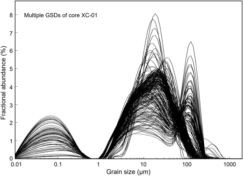
The grain size frequency distribution curves of each sample in the core XC-01.
The GSDs of modern sediment samples around core XC-01 can be clearly distinguished, indicating distinct transport paths [44] (Figure 6a, d–f). The GSD of river sediments is unimodal and coarse, with an average of 81.23 µm and a mode of 116.29 µm. The GSDs of lake sediments are multimodal, with an average of 34.96 µm and a mode of 13.61 µm. The GSDs of the dust sample are bimodal and slightly fine, with an average of 26.53 µm and a mode of 37.97 µm.
![Figure 6
GSD of modern samples (a) and pictures from the sampling sites (d–f) [46]. EM modeling results for the core XC-01 and GSDs of the four EMs (b). Standard deviation diagram of grain size in the core XC-01 (c).](/document/doi/10.1515/geo-2022-0717/asset/graphic/j_geo-2022-0717_fig_006.jpg)
GSD of modern samples (a) and pictures from the sampling sites (d–f) [46]. EM modeling results for the core XC-01 and GSDs of the four EMs (b). Standard deviation diagram of grain size in the core XC-01 (c).
The EM modeling approach based on the grain size data of XC-01 samples indicated that four EM models demonstrate a satisfactory fit with high R 2 values (0.982) and a low average angular deviation (3.75). All EM models (EM1 to EM4) are unimodal (Figure 6b). Peaks of EM1, EM2, EM3, and EM4 are at 0.05, 5.5, 30, and 145 µm, respectively. The grain size-standard deviation values of XC-01 samples are displayed in Figure 6c. There are three distinct peaks on the grain size-standard deviation curves, corresponding to 0.07, 23, and 140 µm. The sensitive grain size components (S.D.1, S.D.2, and S.D.3) show good agreement with the EMs (EM1, EM3, and EM4), except for the EM2.
5 Discussion
5.1 Implications of the LOI and grain size components in the core XC-01
The lithology of XC-01 was identified as the bottom lacustrine sediments and the upper peat sediments, supported by the organic matter content, silicate content, and dry bulk density (Figures 2 and 3). The peatland initiation following the paleo-lake drying up indicates the dry climate [45]. However, the increases (decreases) in organic matter content since the peatland initiation are more likely to reflect more (less) local vegetation biomass and thus indicate warm-wet (cold-dry) climate conditions [6,26].
The sensitive components obtained through EM and grain size-standard deviation analysis corresponded well in three components (Figure 6b and c). As different GSDs are caused by different transmission processes, the environmental implications of the sensitive components are also different. The components EM1 and S.D.1 are unimodal and the grain size peaks are consistent. However, no peak of ∼0.05 µm was found in modern sediment samples with grain size ranging from 0.04 to 2,000 µm [46] (Figure 6a). The very fine grain size component (∼0.05 µm peak) may derive from local biochemical processes of pedogenesis and the transmission of high-altitude airstreams, but its source needs further verification. There is no grain size component corresponding to fine component EM2 (3–10 µm) in the grain size-standard deviation results. A previous study [47] distinguished the fine component with a modal grain size between 2 and 10 mm in a few samples from the eastern QTP and interpreted it as the background dust load of the high-altitude westerly airstreams. Therefore, we did not define the fine population of 2–10 µm as a sensitive grain size component.
The components EM3 and S.D.2 are unimodal and consistent with the modern dust grain size peak (12–50 µm) [46] (Figure 6a). The Chinese Loess Plateau (CLP) is a typical aeolian sedimentary region, and the annual or seasonal GSD peaks of modern dust in Huanxian, Xifeng, Binxian, and Liquan of the CLP vary from 10 to 60 µm [48]. Cy et al. also found that the grain size of dust storms, which mostly happened in winter and spring in the eastern Qinghai Province, averaged 30–40 µm and their peaks varied from 20 to 70 µm [49]. In addition, the modern dust observation and loess deposition analysis around the Zoige Basin suggest that the peaks of dust grain size exhibited a modal size of ∼40 µm (ranging from 20 to 70 µm) [42,50,51]. Past changes in dust sediment content were closely related to the contemporary intensity of the Westerly jet stream, winter monsoon, and aridity [52,53,54], and it is widely used to reconstruct climate changes based on lake and peat sediments [35,36,41,42,55,56]. Previous studies on the eastern QTP suggested that dust components were attributed to sandstorms generated by the low-altitude north Westerly jet [36], and the plateau interior is the dust source [57]. Therefore, both EM3 and S.D.2 can be regarded as climatic aridity and Westerly indices in the Zoige Basin [36,58].
The components EM4 and S.D.3 are unimodal and consistent with the modern floodplain grain size peak (70–200 µm). Flood stream can inundate the floodplain and bring coarser sediments, which may be influenced by the change in regional precipitation [35,41,59]. This reference floodplain sample was taken from the Black River, a tributary of the Yellow River, which has a low discharge and velocity. Xing Co Lake is located at the mountain top, and there is no evidence of any long-term stable rivers flowing into the lake. The sand-carrying capacity of runoff erosion formed by rainfall might be similar to that of the Black River. The south side of Xing Co Lake has a long-term dry outlet, and overflow only occurs when the lake water level exceeds this outlet. The elevation of the XC-01 site is lower than this outlet and located on the northern side of the lake, indicating that the sampling site was in a semi-closed state during sedimentation, likely minimizing interference from the outflow. Therefore, the peak grain size of fluvial-like sand in XC-01 is in good agreement with that of the floodplain of Heihe River, which is a good indicator of past flood events, and EM4 and S.D.3 can be regarded as extreme hydroclimate events (flood and severe rainfall events) in the Zoige Basin.
5.2 Hydroclimatic changes on the eastern QTP since 10 ka.
The overall drying trend and centennial-millennium scale climate events were revealed in the Zoige Basin over the past 10 ka by the LOI and grain size of core XC-01 (Figures 3, 4 and 7). During the Early Holocene (10–7 ka), the Xing Co paleolake was larger and expanded to the XC-01 site. The lithology of core XC-01 consisted of high clay content and very low eolian silt (Figures 4b and 7c). Extreme precipitation events have accelerated the slope erosion, leading to enhanced slope runoff and the introduction of an abundant coarse grain size component into the sediment (e.g., 9.7–9.5 ka, 8.9–8.5 ka, 8.1–7.8 ka, 7.5–7.1 ka) (Figure 7e and f). The unstable climate of the early Holocene has also been reported from the TOC record in the Zoige Basin [67]. After 7 ka, the lake area gradually shrank and formed a local shallow swamp environment. This facilitated the growth of aquatic plants and the preservation of litter, and more organic matter deposited. An extreme drought event occurred at ∼5.5 ka, resulting in the changes from lake to peatland (Figure 7a–c), and the XC-01 site was no longer submerged until the present. The ∼5.5 ka event was also documented in the LOI from ZB10-C14, approximately 89 km south of Xing Co Lake [68], which was the so-called “mid-Holocene transition” in the northern hemisphere [69,70,71,72,73,74,75]. Peat was deposited continuously after the middle Holocene, but the climate remained unstable with several drought events (Figure 7a and b). Five significant drought events occurred at ∼4.3, 2.8, 1.8, 1.3, and 0.5 ka, during which the content of organic matter decreased and the input of dust components increased (Figure 7c). A dust record of Hongyuan peat [36], 120 km south of Xing Co Lake, showed that multi-drought events with different amplitudes also occurred during the late Holocene, which suggested that dust of the Zoige Basin was mainly brought by the northern westerly jet streams and the regional aridity was one of the main sources [58]. The organic matter content of three peat cores in the Zoige Basin [6] was high and stable in the early Holocene, and several abrupt drops occurred in the late Holocene (Figure 8d). Such pattern coincides with the hydroclimatic changes in the XC-01. The similar trends in the Holocene climate change at different sites indicate a consistent regional climatic pattern across the Zoige Basin during the Holocene [26].
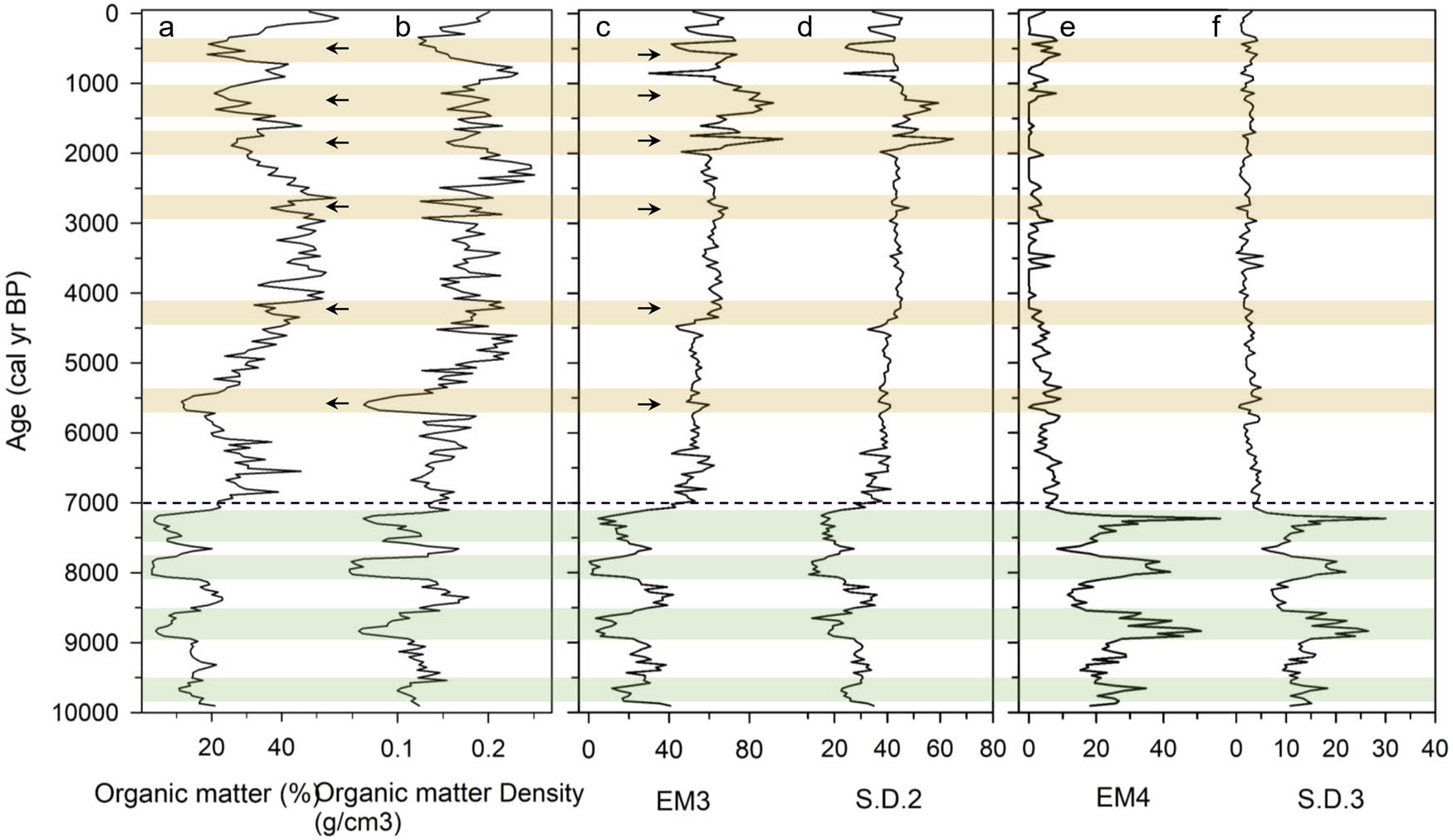
Variations of the organic matter (%) (a), organic matter density (g/cm3) (b), EM3 (c), S.D.2 (d), EM4 (e), and S.D.3 (f) since 10 ka in the core XC-01.
![Figure 8
Comparison of core XC-01 records with other records during the last 10 ka. Organic matter%, EM3, and EM4 from this study (a–c); (d) integrated curve of organic matter content in three peat cores of the Zoige Basin (6); (e) integrated curve of seven AP% series of the Zoige Basin [46]; (f) AP% record from ZB10-C9 of the Zoige Basin [60]; (g) Qinghai Lake Asian summer monsoon index (SMI) based on TOC flux [54]; (h) AP% record from a core of Genggahai Lake [19]; (i) CaCO3% record from a core of Lugu Lake [9]; (j) AP% record from core LG08 of Lugu Lake [61]; (k) PC1 record extracted from the Poya and Dongge [62] δ18O records at an even spacing of 16 years [63]; (l) ENSO event index recorded by the lacustrine sediment from the Laguna Pallcacocha [64]; (m) ice drift record of the North Atlantic [65]; and (n) solar insolation [66] (dashed red line, 34°N solar insolation; solid red line, the insolation differential between 30°N and 30°S).](/document/doi/10.1515/geo-2022-0717/asset/graphic/j_geo-2022-0717_fig_008.jpg)
Comparison of core XC-01 records with other records during the last 10 ka. Organic matter%, EM3, and EM4 from this study (a–c); (d) integrated curve of organic matter content in three peat cores of the Zoige Basin (6); (e) integrated curve of seven AP% series of the Zoige Basin [46]; (f) AP% record from ZB10-C9 of the Zoige Basin [60]; (g) Qinghai Lake Asian summer monsoon index (SMI) based on TOC flux [54]; (h) AP% record from a core of Genggahai Lake [19]; (i) CaCO3% record from a core of Lugu Lake [9]; (j) AP% record from core LG08 of Lugu Lake [61]; (k) PC1 record extracted from the Poya and Dongge [62] δ18O records at an even spacing of 16 years [63]; (l) ENSO event index recorded by the lacustrine sediment from the Laguna Pallcacocha [64]; (m) ice drift record of the North Atlantic [65]; and (n) solar insolation [66] (dashed red line, 34°N solar insolation; solid red line, the insolation differential between 30°N and 30°S).
5.3 Forcing of hydroclimatic changes and fast response of vegetation in the eastern QTP
The climate of the eastern QTP is modulated primarily by the strength of the ASM, and the Indian Summer Monsoon (ISM) subsystem is the main source of regional precipitation [4]. Climate records dating back to 1.74 Ma of the Zoige Basin indicate that the climate on the eastern QTP was influenced by high-latitude ice volume (∼100 ka cycles) and low-latitude solar insolation (∼20 ka cycles) on the orbital scale [4]. Previous studies have suggested that summer solar insolation and sea-surface temperature anomaly could play important roles in regional environmental evolution on multi-millennium scales during the Holocene and resulted in the cold and dry trend on the eastern QTP from the early-mid Holocene to the mid-late Holocene [6,15,26,42,76,77]. In addition, the summer monsoon weakened and abrupt aeoline-sand deposition events in the eastern QTP are likely linked to cooling events in the North Atlantic and the interactions between tropical-ocean and atmosphere [6,7,59,72]. Therefore, it is unsurprising that the Holocene hydroclimatic fluctuations of Xing Co Lake, eastern QTP, show the teleconnection mechanisms with the high-low latitude atmosphere-ocean processes and solar insolation.
The Holocene climate records (except pollen) from the eastern QTP generally exhibit a consistent pattern of early and middle Holocene wetness followed by a late Holocene drying [6,7,12,19,36,42,54,58,59,67,78,79,80,81]. While most records support this pattern, there are a few conflicting records [14,77], potentially influenced by factors such as local topography. To examine the underlying mechanism of the Holocene climate in the Xing Co Lake, we further compared its LOI and grain size records with other climate records. The δ18O variation of stalagmites in southern China is influenced by the ASM, providing a high-resolution monsoon history of the Holocene [62,82]. A high-resolution PC1 record extracted from principal component analysis on the Poya [63] and Dongge [83] δ18O records indicated a primary mode of hydroclimatic variation in southwestern China [63]. The hydroclimatic evolution pattern appears to be synchronized between the stalagmites of southwest China and the lake/peat sediments of the eastern QTP (Figure 8c, d, g, i, k). For example, the optimal hydroclimatic conditions occurred in the early Holocene.
Summer insolation is an important driving factor of ASM climate evolution, but the delayed Holocene climate records in the eastern QTP have been reported [19,76]. Our hydroclimatic records more closely align with the insolation differential between 30°N and 30°S, rather than the summer insolation at 34°N. This suggests that rising rainfall during the early Holocene is a response to the enhanced interhemispheric summer insolation differential forcing (Figure 8n). The consistency of Xing Co Lake with stalagmite δ18O (Figure 8k) and modern streamlines simulation evidence [4] indicate that precipitation over the eastern QTP primarily originates from the southern subtropical Indian Ocean through the ISM [83]. The vapor flux of the ISM is driven by the interhemispheric pressure gradient, which is coupled with the interhemispheric insolation gradient in the tropics [84,85]. In addition, the intensity of Asian monsoon and Australian monsoon is also regulated by El Niño Southern Oscillation (ENSO) states [86]. During a La Niña state, the West Pacific subtropical high recedes to the east while the ISM moves northeastward easily, resulting in more precipitation in the Asian monsoon region, whereas less precipitation during El Niño periods [87]. The coupling between ENSO and the ASM has also been confirmed in the Holocene and earlier [86,88]. Consequently, the rare El Niño event prior to 7 ka [64] (Figure 8i) could promote the Indian monsoon northward. Therefore, the extreme hydroclimatic events in the Zoige Basin during the Early Holocene were most likely driven by low El Niño events and high interhemispheric insolation gradient, whereas the increase in the El Niño event and the decrease in interhemispheric insolation gradient during the middle and late Holocene caused the weakening of monsoon, which in turn led the drying of the eastern QTP.
While abrupt variations in the Holocene climate on centennial to millennial scales in the eastern QTP have been reported in many studies [6,36,59,72,81,89], the amplitudes and timings of these climate events remain controversial. The mechanism is still unclear and several hypotheses have been proposed. Our LOI and grain size time series (Figure 8a-c), indicated a series of abrupt events in the regional hydroclimate evolution during the mid-late Holocene. For example, the EM3 shows multiple increases, which may be related to regional dry condition and strengthening of the Westerly jet. These events superimpose the general drying tendency mentioned above. The comparison between the XC-01 records and the proxy records of drift ice (Figure 8n) since the 6 ka BP shows that drops in the organic matter and increases in the EM3 records of XC-01 correspond to the IRD events. In addition, the long-lasting and intense H4 event is consistent with the middle Holocene dry event in the XC-01 (Figure 8a), and the sedimentary environment of the XC-01 site has not recovered to lake status since then. We inferred that the temperature anomalies in the high northern latitudes could modulate regional climate on the centennial to millennial timescales [6]. At the same time, the IRD events can lead to a weak effect of the ocean thermohaline circulation (THC) that directly determines the redistribution of energy on the Earth [90,91]. Consequently, weakened THC will decrease the cross-equatorial ocean circulation and lead to the formation of the weak ISM following the cooling of the North Atlantic [54,59]. It is noteworthy that there were no extreme drought events in Xing Co Lake corresponding to the early Holocene IRD events, which may be due to the different potential climatic boundaries before and after the middle Holocene on the eastern QTP [92].
The percentage of arboreal pollen (AP%) is an important index of regional forest coverage or vegetation openness during the Holocene. Delayed AP% responses to climate change are frequently reported [16,18,19,93], which induces uncertainties in the discussion of climate change based on fossil pollen records. However, the delayed response of vegetation shows regional differences. There are multiple and continuous vegetation zones on the eastern QTP, which are sensitive to climate change. It is important to clarify the characteristics of the Holocene vegetation response to regional climate. We compared three regions on the eastern QTP (Qinghai Lake, Zoige Basin, and Hengduan Mountain) and selected independent climate records from different studies with reliable ages and high sample resolutions. There are many palynological records in the Zoige Basin. An AP (Z-scores) record synthesized from seven AP% series [3,26,46,68,94,95,96] and an AP% record of ZB10-C9 [60] with stable deposition and a resolution of ∼50 years are used as proxies for regional vegetation. There are four clear peaks in the AP% record during the early Holocene, which basically correspond to the record of XC-01 (Figure 8c, e, and f). This suggests that regional vegetation change is closely related to climate. In other words, the rapid rise of AP% is feedback to the increase of regional precipitation. The misalignment of the first two events might be due to the uncertainties in age models. The forest coverage gradually decreased with the drying tendency and reached the minimum at ∼1 ka BP (Figure 8e and f). This suggests vegetation also responded to multiple climatic drought events during the mid-late Holocene in the Zoige Basin. In addition, hydroclimatic and AP% records from around Qinghai Lake and Hengduan Mountain exhibit similar trends and abrupt changes to the hydroclimatic records of Xing Co Lake, but the amplitudes of fluctuation differ among these sites. Admittedly, the relationship between climate and vegetation on the eastern QTP is very complex, but signals of long-term climate change and abrupt climate events can be faithfully imprinted on regional vegetation.
6 Conclusions
A new high-resolution hydroclimatic record based on LOI and grain size is provided from Xing Co Lake, eastern QTP. This record spans from 10 ka to the present, covering a significant portion of the Holocene. We then reviewed and analyzed other climatic records and vegetation evolution, and the main findings are outlined below:
LOI and grain size from lacustrine-peat sediments are good proxies for hydroclimatic reconstruction. Through the grain size-standard deviation and integration of the EM model, the modern dust grain size peak (12–50 µm) corresponds to the climatic aridity and Westerly jet intensity in the Zoige Basin. The modern floodplain grain size peak (70–110 µm) can be regarded as extreme hydroclimatic events proxy (flood and severe rainfall events) in the Zoige Basin.
The hydroclimatic record reveals a drying trend and centennial-millennium scale climate changes in the Zoige Basin over the past 10 ka. During the Early Holocene (10–7 ka), the Xing Co paleolake was larger and four extreme precipitation events occurred. An extreme drought event occurred at ∼5.5 ka, after that, the climate was drier and unstable with several drought events.
Combined high- and low-latitude forcing shaped the evolution of the eastern QTP climate. The precipitation over the eastern QTP mainly comes from the southern subtropical Indian Ocean through the ISM. Holocene climate records from the eastern QTP show a similar pattern of early-mid Holocene wetness followed by drying. The rising rainfall during the early Holocene of Xing Co Lake is a response to the high insolation differential between 30°N and 30°S and low El Niño event, whereas mid-late Holocene drying responded to low insolation and high El Niño event. The extreme dry events in the late Holocene correspond well to each of the IRD events. The North Atlantic climate may be linked to abrupt reorganizations of the ocean thermohaline circulation, indirectly leading to weak ISM and dry events in the eastern QTP.
Vegetation succession in the eastern QTP during the Holocene was responsive to changes in hydroclimatic conditions. By comparison with the independent hydroclimatic and pollen (AP%) records of around Qinghai Lake, Zoige Basin, and Hengduan Mountain, it is found that the evolution trend and events of AP% are basically consistent with the local climate. It means that forest coverage could rapidly respond to the hydroclimate changes during the Holocene, but the relationship between vegetation and climate in the eastern QTP is very complex and requires further study.
Acknowledgments
This work was supported by the Foundation of Hunan Province [2023JJ40099, 23B0678], the National Natural Science Foundation of China [42107475, 42071114, 42277454, 42372352], the National Key Research and Development Program of China [2022YFF0801504], the Foundation of HIST [2022HSKFJJ008], and the Strategic Priority Research Program of the Chinese Academy of Sciences [No. XDA20070101]. ChatGPT provided help with language editing. The authors thank the anonymous reviewers for their constructive comments and useful suggestions.
-
Author contributions: Weihe Ren: project administration, conceptualization, writing original draft, visualization. Zijian Liu: resources, visualization. Quan Li and Guitian Yi: writing – review and editing. Feng Qin: project administration, writing – review and editing, visualization.
-
Conflict of interest: The authors declare no conflict of interest.
-
Data availability statement: The datasets generated during and/or analysed during the current study are available from the corresponding author on reasonable request.
References
[1] Mitchell JFB. Greenhouse Warming: Is the Mid-Holocene a Good Analogue? J Clim. 1990;3(11):1177–92.10.1175/1520-0442(1990)003<1177:GWITMH>2.0.CO;2Search in Google Scholar
[2] van den Bos V, Rees A, Newnham R, Vandergoes M, Wilmshurst J, Augustinus P. Holocene temperature, humidity and seasonality in northern New Zealand linked to Southern Hemisphere summer insolation. Quat Sci Rev. 2018;201:77–88.10.1016/j.quascirev.2018.10.008Search in Google Scholar
[3] Zhou WJ, Yu SY, Burr GS, Kukla GJ, Jull AJT, Xian F, et al. Postglacial changes in the Asian summer monsoon system: a pollen record from the eastern margin of the Tibetan Plateau. Boreas. 2010;39(3):528–39.10.1111/j.1502-3885.2010.00150.xSearch in Google Scholar
[4] Zhao Y, Tzedakis PC, Li Q, Qin F, Cui QY, Liang C, et al. Evolution of vegetation and climate variability on the Tibetan Plateau over the past 1.74 Myr. Sci Adv. 2020;6:eaay6193.10.1126/sciadv.aay6193Search in Google Scholar
[5] Zhao Y, Tang Y, Yu ZC, Li H, Yang B, Zhao WW, et al. Holocene peatland initiation, lateral expansion, and carbon dynamics in the Zoige Basin of the eastern Tibetan Plateau. Holocene. 2014;24(9):1137–45.10.1177/0959683614538077Search in Google Scholar
[6] Li Q, Zhao Y. Abrupt climatic changes in the Holocene recorded by the history of peat formation in Zoige Basin on the eastern Tibetan Plateau (in Chinese). Quat Sci. 2019;39(6):1323–32.Search in Google Scholar
[7] Qiang MR, Liu YY, Jin YX, Song L, Huang XT, Chen FH. Holocene record of eolian activity from Genggahai Lake, northeastern Qinghai-Tibetan Plateau, China. Geophys Res Lett. 2014;41(2):589–95.10.1002/2013GL058806Search in Google Scholar
[8] Sun WW, Zhang EL, Shen J, Chen R, Liu EF. Black carbon record of the wildfire history of western Sichuan Province in China over the last 12.8 ka. Front Earth Sci. 2016;10(4):634–43.10.1007/s11707-015-0546-zSearch in Google Scholar
[9] Zheng Q, Zhang HC, Ming QZ, Chang FQ, Meng HW, Zhang WX, et al. Vegetational and environmental changes since 15ka B.P. recorded by Lake Lugu in the southwest Monsoon domain region. Quat Sci. 2014;34(6):1314–26.Search in Google Scholar
[10] Zheng YH, Zhou WJ, Liu Z, Liu X. The n-alkanol paleoclimate records in two peat deposits: a comparative study of the northeastern margin of the Tibetan Plateau and Northeast China. Environ Earth Sci. 2011;63(1):135–43.10.1007/s12665-010-0676-2Search in Google Scholar
[11] Xu H, Liu B, Lan JH, Sheng EG, Che S, Xu S. Holocene peatland development along the eastern margin of the Tibetan Plateau. Quat Res. 2013;80(1):47–54.10.1016/j.yqres.2013.04.001Search in Google Scholar
[12] Zhang EL, Meng XQ, Ning DL, Shulmeister J, Sun WW, Zhang WF, et al. Holocene extreme hydroclimate events in the Asian monsoon region were more frequent during cooler intervals. Commun Earth Environ. 2023;4(1):344.10.1038/s43247-023-00997-xSearch in Google Scholar
[13] Li WJ, Wang NN, Liang C, Yu SY, Tian F, Cao XY. Regional peculiarities in the importance of precipitation and temperature on mid-to-late Holocene arboreal degradation on the eastern Tibetan Plateau. Glob Planet Change. 2023;229:104252.10.1016/j.gloplacha.2023.104252Search in Google Scholar
[14] Zhao Y, Yu ZC, Chen FH, Ito E, Zhao C. Holocene vegetation and climate history at Hurleg Lake in the Qaidam Basin, northwest China. Rev Palaeobot Palynol. 2007;145(3):275–88.10.1016/j.revpalbo.2006.12.002Search in Google Scholar
[15] Zhao Y, Yu ZC. Vegetation response to Holocene climate change in East Asian monsoon-margin region. Earth-Sci Rev. 2012;113(1–2):1–10.10.1016/j.earscirev.2012.03.001Search in Google Scholar
[16] Zhao Y, Yu ZC, Chen FH, Zhang JW, Yang B. Vegetation response to Holocene climate change in monsoon-influenced region of China. Earth-Sci Rev. 2009;97(1–4):242–56.10.1016/j.earscirev.2009.10.007Search in Google Scholar
[17] Yin Y, Liu HY, Liu G, Hao Q, Wang HY. Vegetation responses to mid-Holocene extreme drought events and subsequent long-term drought on the southeastern Inner Mongolian Plateau, China. Agric For Meteorol. 2013;178-179:3–9.10.1016/j.agrformet.2012.10.005Search in Google Scholar
[18] Cheng J, Wu HB, Liu ZY, Gu P, Wang JJ, Zhao C, et al. Vegetation feedback causes delayed ecosystem response to East Asian Summer Monsoon Rainfall during the Holocene. Nat Commun. 2021;12(1):1843.10.1038/s41467-021-22087-2Search in Google Scholar PubMed PubMed Central
[19] Li Y, Qiang MR, Huang XZ, Zhao YT, Leppänen JJ, Weckström J, et al. Lateglacial and Holocene climate change in the NE Tibetan Plateau: Reconciling divergent proxies of Asian summer monsoon variability. Catena. 2021;199:105089.10.1016/j.catena.2020.105089Search in Google Scholar
[20] Xu DK, Lu HY, Chu GQ, Shen CM, Sun Q, Wu J, et al. Fast response of vegetation in East Asia to abrupt climatic events during the last deglaciation. PNAS Nexus. 2023;2(3):1–10.10.1093/pnasnexus/pgad061Search in Google Scholar PubMed PubMed Central
[21] Chen FH, Yu ZC, Yang ML, Ito E, Wang SM, Madsen DB, et al. Holocene moisture evolution in arid central Asia and its out-of-phase relationship with Asian monsoon history. Quat Sci Rev. 2008;27(3):351–64.10.1016/j.quascirev.2007.10.017Search in Google Scholar
[22] Li JJ. The environmental effects of the uplift of the Qinghai-Xizang Plateau. Quat Sci Rev. 1991;10(6):479–83.10.1016/0277-3791(91)90041-RSearch in Google Scholar
[23] Wang YF, Wang SM, Xue B, Ji L, Wu JL, Xia WL, et al. Sedimentological basis of the ancient lake age of Zoige seized by the Yellow River (in Chinese). Chin Sci Bull. 1995;40(8):723–5.Search in Google Scholar
[24] Shen CM, Tang LY, Wang SM, Li CH, Liu KB. Pollen records and time scale for the RM core of the Zoige Basin, northeastern Qinghai-Tibetan Plateau. Chin Sci Bull. 2005;50(6):553–62.10.1007/BF02897480Search in Google Scholar
[25] Zhang XS. Vegetation of China and its geographic patterns (in Chinese). Beijing: China Geology Publishing House; 2007.Search in Google Scholar
[26] Zhao Y, Yu ZC, Zhao WW. Holocene vegetation and climate histories in the eastern Tibetan Plateau: controls by insolation-driven temperature or monsoon-derived precipitation changes? Quat Sci Rev. 2011;30(9–10):1173–84.10.1016/j.quascirev.2011.02.006Search in Google Scholar
[27] Mu GC. Natural situation and geomorphic development of Zoige Plateau (in Chinese). J Southwest China Norm Univ. 1982;4:42–6.Search in Google Scholar
[28] Li XY, Yao ZY, Wang HW, Xiao JH. The driving mechanism of sandy desertification in the Zoige Basin of China (in Chinese). J Desert Res. 2015;35(1):51–9.Search in Google Scholar
[29] Wu JL, Li SJ, Wang SM, Xia WL, Li WC, Yang XD. Modern climatic signals recorded in Xincuo Lake sediments in Zoige Basin, Eastern Tibetan Plateau, China (in Chinese). J Lake Sci. 2000;12(4):291–6.10.18307/2000.0401Search in Google Scholar
[30] Zhang YR, Li YQ, Liu L, Wang NN, Cao XY. No evidence of human disturbance to vegetation in the Zoige Region (north-eastern Tibetan Plateau) in the last millennium until recent decades. Palaeogeogr Palaeoclimatol Palaeoecol. 2022;589:110843.10.1016/j.palaeo.2022.110843Search in Google Scholar
[31] Reimer PJ, Austin WEN, Bard E, Bayliss A, Blackwell PG, Bronk Ramsey C, et al. The IntCal20 Northern Hemisphere Radiocarbon Age Calibration Curve (0–55 cal kBP). Radiocarbon. 2020;62(4):725–57.10.1017/RDC.2020.41Search in Google Scholar
[32] Dean WE. Determination of Carbonate and Organic-Matter in Calcareous Sediments and Sedimentary-Rocks by Loss on Ignition – Comparison with Other Methods. J Sediment Pet. 1974;44(1):242–8.10.1306/74D729D2-2B21-11D7-8648000102C1865DSearch in Google Scholar
[33] Boulay S, Colin C, Trentesaux A, Frank N, Blamart D. South China Sea sediment response to the Pleistocene monsoon variations. Proceedings of the Ocean Drilling Program. Vol. 1, No. 6, Scientific Results; 2003. p. 1–21.Search in Google Scholar
[34] Wan SM, Li AC, Stuut JBW, Xu FJ. Grain-size records at ODP site 1146 from the northern South China sea: Implications on the east Asian monsoon evolution since 20 Ma. Sci China Ser D-Earth Sci. 2007;50(10):1536–47.10.1007/s11430-007-0082-0Search in Google Scholar
[35] Li NN, Chambers FM, Yang JX, Jie DM, Liu LD, Liu HY, et al. Records of East Asian monsoon activities in Northeastern China since 15.6 ka, based on grain size analysis of peaty sediments in the Changbai Mountains. Quat Int. 2017;447:158–69.10.1016/j.quaint.2017.03.064Search in Google Scholar
[36] Bai YY, Zeng MX, Li FQ, Song YG, Wu YQ, Wu JH, et al. The evolution history of Asian monsoon and westerly winds over the past 14,000 years: Evidences from grain size of ash in the Hongyuan peat on the eastern Qinghai-Tibetan Plateau. Palaeogeogr Palaeoclimatol Palaeoecol. 2023;630:111814.10.1016/j.palaeo.2023.111814Search in Google Scholar
[37] Weltje GJ. End-member modeling of compositional data: Numerical-statistical algorithms for solving the explicit mixing problem. Math Geol. 1997;29(4):503–49.10.1007/BF02775085Search in Google Scholar
[38] Weltje GJ, Prins MA. Muddled or mixed? Inferring palaeoclimate from size distributions of deep-sea clastics. Sediment Geol. 2003;162(1–2):39–62.10.1016/S0037-0738(03)00235-5Search in Google Scholar
[39] Paterson GA, Heslop D. New methods for unmixing sediment grain size data. Geochem, Geophys, Geosystems. 2015;16(12):4494–506.10.1002/2015GC006070Search in Google Scholar
[40] Hateren JAV, Prins MA, Balen RTV. On the genetically meaningful decomposition of grain-size distributions: A comparison of different end-member modelling algorithms. Sediment Geol. 2017;375:49–71.10.1016/j.sedgeo.2017.12.003Search in Google Scholar
[41] Xiao JL, Chang ZG, Si B, Qin XG, Itoh S, Lomtatidze Z. Partitioning of the grain-size components of Dali Lake core sediments: evidence for lake-level changes during the Holocene. J Paleolimnol. 2009;42(2):249–60.10.1007/s10933-008-9274-7Search in Google Scholar
[42] Liu XX, Vandenberghe J, An ZS, Li Y, Jin ZD, Dong JB, et al. Grain size of Lake Qinghai sediments: Implications for riverine input and Holocene monsoon variability. Palaeogeogr Palaeoclimatol Palaeoecol. 2016;449:41–51.10.1016/j.palaeo.2016.02.005Search in Google Scholar
[43] Wang ZD, Huang CC, Pang JL, Liu AN, Zhou YL, Zha XC. Provenance Analysis and Reconstruction of the Climate Change for the Holocene Loess profile in the Zhuanglang Country of Gansu Province. China (Chin) Acta Sedimentol Sin. 2020;38(4):781–9.Search in Google Scholar
[44] Sun DH, Chen FH, Bloemendal J, Su RX. Seasonal variability of modern dust over the Loess Plateau of China. J Geophys Res: Atmospheres. 2003;108(D21):1–10.10.1029/2003JD003382Search in Google Scholar
[45] Zhang ZQ, Yao Q, Xu QH, Jiang M, Zhu TC. Hydrological and palynological evidence of wetland evolution on the Sanjiang Plain (NE China) in response to the Holocene East Asia summer monsoon. Catena. 2021;203:105332.10.1016/j.catena.2021.105332Search in Google Scholar
[46] Ren WH. The Vegetation and Climate Changes of the Eastern Tibetan Plateau since the Last Interglacial (in Chinese). Beijing; 2020.Search in Google Scholar
[47] Sun DH. Monsoon and westerly circulation changes recorded in the late Cenozoic aeolian sequences of Northern China. Glob Planet Change. 2004;41(1):63–80.10.1016/j.gloplacha.2003.11.001Search in Google Scholar
[48] Wang XY, Yi SW, Lu HY, Vandenberghe J, Han Z. Aeolian process and climatic changes in loess records from the northeastern Tibetan Plateau: Response to global temperature forcing since 30 ka. Paleoceanography. 2015;30(6):612–20.10.1002/2014PA002731Search in Google Scholar
[49] Cy E, Xi YS, Sun YJ, Zhao YJ, Yang L, Lv SC. Institute of Geographic Sciences and Natural Resources Research, Chinese Academy of Sciences (in Chinese). J Salt Lake Res. 2016;24(2):62–74.Search in Google Scholar
[50] Liu WM, Yang SL, Fang XM. Loess Recorded Climatic Change During the Last Glaciation on the Eastern Tibetan Plateau, Western Sichuan. J Jilin Univ (Earth Sci Ed). 2013;43(3):974–82.Search in Google Scholar
[51] Stauch G, Lai ZP, Lehmkuhl F, Schulte P. Environmental changes during the late Pleistocene and the Holocene in the Gonghe Basin, north-eastern Tibetan Plateau. Palaeogeogr Palaeoclimatol Palaeoecol. 2016;509:144–55.10.1016/j.palaeo.2016.12.032Search in Google Scholar
[52] Lu HY, An ZS. Paleoclimatic significance of grain size composition of loess in the Loess Plateau. Sci China Earth Sci. 1998;28(3):278–83.Search in Google Scholar
[53] Zhang XY, Arimoto R, An ZS. Glacial and interglacial patters for Asian dust transport. Quat Sci Rev. 1999;18(6):811–9.10.1016/S0277-3791(98)00028-6Search in Google Scholar
[54] An ZS, Colman SM, Zhou WJ, Li X, Brown ET, Jull AJT, et al. Interplay between the Westerlies and Asian monsoon recorded in Lake Qinghai sediments since 32 ka. Sci Rep. 2012;2:6191–7.10.1038/srep00619Search in Google Scholar PubMed PubMed Central
[55] Wolin JA. Late Holocene lake-level and lake development signals in Lower Herring Lake, Michigan. J Paleolimnol. 1996;15(1):19–45.10.1007/BF00176988Search in Google Scholar
[56] Ma L, Wu JL, Abuduwaili J. Variation in aeolian environments recorded by the particle size distribution of lacustrine sediments in Ebinur Lake, northwest China. SpringerPlus. 2016;5(1):481–8.10.1186/s40064-016-2146-0Search in Google Scholar PubMed PubMed Central
[57] Yang SL, Luo YL, Li Q, Liu WM, Chen ZX, Liu L, et al. Comparisons of topsoil geochemical elements from Northwest China and eastern Tibetan Plateau identify the plateau interior as Tibetan dust source. Sci Total Environ. 2021;798:149240.10.1016/j.scitotenv.2021.149240Search in Google Scholar PubMed
[58] Hu GY, Yu LP, Dong ZB, Lu J, Li J, Wang Y, et al. Holocene aeolian activity in the Zoige Basin, northeastern Tibetan Plateau. China Catena. 2018;160:321–8.10.1016/j.catena.2017.10.005Search in Google Scholar
[59] Ning DL, Zhang EL, Sun WW, Chang J, Shulmeister J. Holocene Indian Summer Monsoon variation inferred from geochemical and grain size records from Lake Ximenglongtan, southwestern China. Palaeogeogr Palaeoclimatol Palaeoecol. 2017;487(Supplement C):260–9.10.1016/j.palaeo.2017.09.008Search in Google Scholar
[60] Li H. Holocene pollen record and reconstruction of palaeovegetation and palaeoclimate in the Zoige Basin. Tibetan Plateau (in Chinese). Master’s Thesis. Graduate School of Lanzhou University; 2015.Search in Google Scholar
[61] Wang Q, Yang X, Anderson NJ, Dong X. Direct versus indirect climate controls on Holocene diatom assemblages in a sub-tropical deep, alpine lake (Lugu Hu, Yunnan, SW China). Quat Res. 2016;86(1):1–12.10.1016/j.yqres.2016.03.003Search in Google Scholar
[62] Dykoski CA, Edwards RL, Cheng H, Yuan DX, Cai YJ, Zhang ML, et al. A high-resolution, absolute-dated Holocene and deglacial Asian monsoon record from Dongge Cave, China. Earth Planet Sci Lett. 2005;233(1):71–86.10.1016/j.epsl.2005.01.036Search in Google Scholar
[63] Duan FC, Zhang ZQ, Liu DB, Chen JS, Shao QF, Wang YJ. Stalagmite-based long-term and multi-centennial hydroclimatic variations in southwestern China during the Holocene and relations to global climate change. Quat Sci Rev. 2023;319:108327.10.1016/j.quascirev.2023.108327Search in Google Scholar
[64] Moy CM, Seltzer GO, Rodbell DT, Anderson DM. Variability of El Niño/Southern Oscillation activity at millennial timescales during the Holocene epoch. Nature. 2002;420(6912):162–5.10.1038/nature01194Search in Google Scholar PubMed
[65] Bond G, Showers W, Cheseby M, Lotti R, Almasi P, deMenocal P, et al. A Pervasive Millennial-Scale Cycle in North Atlantic Holocene and Glacial Climates. Science. 1997;278(5341):1257–66.10.1126/science.278.5341.1257Search in Google Scholar
[66] Laskar J, Robutel P, Joutel F, Gastineau M, Correia ACM, Levrard B. A long-term numerical solution for the insolation quantities of the Earth. Photogr Sci Photochem. 2004;428(1):261–85.10.1051/0004-6361:20041335Search in Google Scholar
[67] Jia JH, Bai YJ, Wang XF, Zhang PZ, Sang WC, Zhang DZ, et al. Geochemical Significance of the Saturated Hydrocarbons of Limnological Sediments from Zoige Plateau (in Chinese). Acta Sedimentol Sin. 2012;30(4):755–60.Search in Google Scholar
[68] Sun XH, Zhao Y, Li Q. Holocene peatland development and vegetation changes in the Zoige Basin, eastern Tibetan Plateau. Sci China Earth Sci. 2017;60(10):1826–37.10.1007/s11430-017-9086-5Search in Google Scholar
[69] Steig EJ. Mid-holocene climate change. Science. 1999;286(5444):1485–7.10.1126/science.286.5444.1485Search in Google Scholar
[70] Mayewski PA, Rohling EE, Curt Stager J, Karlén W, Maasch KA, David Meeker L, et al. Holocene Clim Var Quat Res. 2004;62(3):243–55.10.1016/j.yqres.2004.07.001Search in Google Scholar
[71] Magny M, Leuzinger U, Bortenschlager S, Haas JN. Tripartite climate reversal in Central Europe 5600–5300 years ago. Quat Res. 2006;65(1):3–19.10.1016/j.yqres.2005.06.009Search in Google Scholar
[72] Miao YF, Jin HL, Liu B, Herrmann M, Sun Z, Wang YP. Holocene climate change on the northeastern Tibetan Plateau inferred from mountain-slope pollen and non-pollen palynomorphs. Rev Photogr Palynol. 2015;221:22–31.10.1016/j.revpalbo.2015.05.006Search in Google Scholar
[73] Bai YJ, Zhang PZ, Gao T, Yu RZ, Zhou PC, Cheng H. The 5400 a BP extreme weakening event of the Asian summer monsoon and cultural evolution. Sci China Earth Sci. 2017;60(6):1171–82.10.1007/s11430-016-9017-3Search in Google Scholar
[74] Wang YB, Shen J, Wang Y, Liu XQ, Cao XY, Herzschuh U. Abrupt mid-holocene decline in the indian summer monsoon caused by tropical indian ocean cooling. Clim Dyn. 2020;55(7):1961–77.10.1007/s00382-020-05363-7Search in Google Scholar
[75] Wu J, Ren WH, Cui QY, Ma YZ, Marquer L, Meng HW, et al. Mid-Holocene pine forest expansion caused by the weakening of the East Asian winter monsoon and linked to climate change in the North Atlantic region. Quat Sci Rev. 2023;320:108349.10.1016/j.quascirev.2023.108349Search in Google Scholar
[76] Chen FH, Wu D, Chen JH, Zhou AF, Yu JQ, Shen J, et al. Holocene moisture and East Asian summer monsoon evolution in the northeastern Tibetan Plateau recorded by Lake Qinghai and its environs: A review of conflicting proxies. Quat Sci Rev. 2016;154:111–29.10.1016/j.quascirev.2016.10.021Search in Google Scholar
[77] Liu B, Jin HL, Sun LY, Su ZZ, Zhang CX, Zhao S. History of moisture change derived from slope sediments of the eastern Gonghe Basin (northeastern Qinghai–Tibetan Plateau) during the last 17 ka. Geol J. 2016;52(4):583–93.10.1002/gj.2795Search in Google Scholar
[78] Bird BW, Polisar PJ, Lei Y, Thompson LG, Yao T, Finney BP, et al. A Tibetan lake sediment record of Holocene Indian summer monsoon variability. Earth Planet Sci Lett. 2014;399(Supplement C):92–102.10.1016/j.epsl.2014.05.017Search in Google Scholar
[79] Zheng YH, Singarayer JS, Cheng P, Yu X, Liu Z, Valdes PJ, et al. Holocene variations in peatland methane cycling associated with the Asian summer monsoon system. Nat Commun. 2014;5(1):4631.10.1038/ncomms5631Search in Google Scholar PubMed PubMed Central
[80] Hillman AL, Abbott MB, Finkenbinder MS, Yu J. An 8,600 year lacustrine record of summer monsoon variability from Yunnan, China. Quat Sci Rev. 2017;174(Supplement C):120–32.10.1016/j.quascirev.2017.09.005Search in Google Scholar
[81] Peng HJ, Bao KS, Yuan LG, Uchida M, Cai C, Zhu YX, et al. Abrupt climate variability since the last deglaciation based on a high-resolution peat dust deposition record from southwest China. Quat Sci Rev. 2021;252:106749.10.1016/j.quascirev.2020.106749Search in Google Scholar
[82] Cheng H, Edwards RL, Sinha A, Spötl C, Yi L, Chen ST, et al. The Asian monsoon over the past 640,000 years and ice age terminations. Nature. 2016;534:640–6.10.1038/nature18591Search in Google Scholar PubMed
[83] Liu JB, Chen JH, Zhang XJ, Li Y, Rao ZG, Chen FH. Holocene East Asian summer monsoon records in northern China and their inconsistency with Chinese stalagmite δ 18 O records. Earth-Sci Rev. 2015;148:194–208.10.1016/j.earscirev.2015.06.004Search in Google Scholar
[84] Zhou WJ, Priller A, Beck JW, Wu ZK, Chen MB, An ZS, et al. Disentangling Geomagnetic and Precipitation Signals in an 80-kyr Chinese Loess Record of 10Be. Radiocarbon. 2007;49(1):137–58.10.1017/S0033822200041977Search in Google Scholar
[85] Zhou WJ, Xian F, Du YJ, Kong XH, Wu ZK. The last 130 ka precipitation reconstruction from Chinese loess 10Be. J Geophys Res: Solid Earth. 2014;119(1):191–7.10.1002/2013JB010296Search in Google Scholar
[86] Beaufort L, van der Kaars S, Bassinot FC, Moron V. Past dynamics of the Australian monsoon: precession, phase and links to the global monsoon concept. Clim Past. 2010;6(5):695–706.10.5194/cp-6-695-2010Search in Google Scholar
[87] Tan M. Trade-wind driven inverse coupling between stalagmite δ18O from monsoon region of China and large scale temperature——circulation effect on decadal to precessional timescales. Quat Sci 31(6):1086–97.Search in Google Scholar
[88] Zhang MM, Bu ZJ, Liu SS, Chen J, Cui YX. Mid-late Holocene peatland vegetation and hydrological variations in Northeast Asia and their responses to solar and ENSO activity. Catena. 2021;203:105339.10.1016/j.catena.2021.105339Search in Google Scholar
[89] Hong YT, Hong B, Lin QH, Zhu YX, Shibata Y, Hirota M, et al. Correlation between Indian Ocean summer monsoon and North Atlantic climate during the Holocene. Earth Planet Sci Lett. 2003;211(3–4):371–80.10.1016/S0012-821X(03)00207-3Search in Google Scholar
[90] Broecker WS, Denton GH. The role of ocean-atmosphere reorganizations in glacial cycles. Quat Sci Rev. 1989;9(4):305–41.10.1016/0277-3791(90)90026-7Search in Google Scholar
[91] Marotzke J. Abrupt climate change and thermohaline circulation: Mechanisms and predictability. Proc Natl Acad Sci U S A. 2000;97(4):1347–50.10.1073/pnas.97.4.1347Search in Google Scholar PubMed PubMed Central
[92] Zhao Y, Liu YL, Guo ZT, Fang KY, Li Q, Cao XY. Abrupt vegetation shifts caused by gradual climate changes in central Asia during the Holocene. Sci China Earth Sci. 2017;60(7):1317–27.10.1007/s11430-017-9047-7Search in Google Scholar
[93] Zhou X, Sun LG, Zhan T, Huang W, Zhou XY, Hao QZ, et al. Time-transgressive onset of the Holocene Optimum in the East Asian monsoon region. Earth Planet Sci Lett. 2016;456:39–46.10.1016/j.epsl.2016.09.052Search in Google Scholar
[94] Wang Y, Zhao ZZ, Qiao YS, Wang SB, Li CZ, Song LF. Oaleoclimate and paleoenvironmental evolution since the late glacial epoch as recorded by sporopollen from the Hongyuan peat section on the Zoige Plateau, northern Sichuan, China. Geol Bull China. 2006;25(7):827–32.Search in Google Scholar
[95] Cheng Y. Amuti-proxy approach to reconstruct climate development since the last glacial maximum in the Ruoegai plateau, northeast Tibetan Plateau. Beijing: Chinese Academy of Geological Sciences; 2014.Search in Google Scholar
[96] Zeng MX. The variation of vegetation and climate and its impact on human activities from Late Deglacial period in western Sichuan. China (in Chinese). Doctoral Dissertation. Graduate School of Nanjing University; 2017.Search in Google Scholar
© 2024 the author(s), published by De Gruyter
This work is licensed under the Creative Commons Attribution 4.0 International License.
Articles in the same Issue
- Regular Articles
- Theoretical magnetotelluric response of stratiform earth consisting of alternative homogeneous and transitional layers
- The research of common drought indexes for the application to the drought monitoring in the region of Jin Sha river
- Evolutionary game analysis of government, businesses, and consumers in high-standard farmland low-carbon construction
- On the use of low-frequency passive seismic as a direct hydrocarbon indicator: A case study at Banyubang oil field, Indonesia
- Water transportation planning in connection with extreme weather conditions; case study – Port of Novi Sad, Serbia
- Zircon U–Pb ages of the Paleozoic volcaniclastic strata in the Junggar Basin, NW China
- Monitoring of mangrove forests vegetation based on optical versus microwave data: A case study western coast of Saudi Arabia
- Microfacies analysis of marine shale: A case study of the shales of the Wufeng–Longmaxi formation in the western Chongqing, Sichuan Basin, China
- Multisource remote sensing image fusion processing in plateau seismic region feature information extraction and application analysis – An example of the Menyuan Ms6.9 earthquake on January 8, 2022
- Identification of magnetic mineralogy and paleo-flow direction of the Miocene-quaternary volcanic products in the north of Lake Van, Eastern Turkey
- Impact of fully rotating steel casing bored pile on adjacent tunnels
- Adolescents’ consumption intentions toward leisure tourism in high-risk leisure environments in riverine areas
- Petrogenesis of Jurassic granitic rocks in South China Block: Implications for events related to subduction of Paleo-Pacific plate
- Differences in urban daytime and night block vitality based on mobile phone signaling data: A case study of Kunming’s urban district
- Random forest and artificial neural network-based tsunami forests classification using data fusion of Sentinel-2 and Airbus Vision-1 satellites: A case study of Garhi Chandan, Pakistan
- Integrated geophysical approach for detection and size-geometry characterization of a multiscale karst system in carbonate units, semiarid Brazil
- Spatial and temporal changes in ecosystem services value and analysis of driving factors in the Yangtze River Delta Region
- Deep fault sliding rates for Ka-Ping block of Xinjiang based on repeating earthquakes
- Improved deep learning segmentation of outdoor point clouds with different sampling strategies and using intensities
- Platform margin belt structure and sedimentation characteristics of Changxing Formation reefs on both sides of the Kaijiang-Liangping trough, eastern Sichuan Basin, China
- Enhancing attapulgite and cement-modified loess for effective landfill lining: A study on seepage prevention and Cu/Pb ion adsorption
- Flood risk assessment, a case study in an arid environment of Southeast Morocco
- Lower limits of physical properties and classification evaluation criteria of the tight reservoir in the Ahe Formation in the Dibei Area of the Kuqa depression
- Evaluation of Viaducts’ contribution to road network accessibility in the Yunnan–Guizhou area based on the node deletion method
- Permian tectonic switch of the southern Central Asian Orogenic Belt: Constraints from magmatism in the southern Alxa region, NW China
- Element geochemical differences in lower Cambrian black shales with hydrothermal sedimentation in the Yangtze block, South China
- Three-dimensional finite-memory quasi-Newton inversion of the magnetotelluric based on unstructured grids
- Obliquity-paced summer monsoon from the Shilou red clay section on the eastern Chinese Loess Plateau
- Classification and logging identification of reservoir space near the upper Ordovician pinch-out line in Tahe Oilfield
- Ultra-deep channel sand body target recognition method based on improved deep learning under UAV cluster
- New formula to determine flyrock distance on sedimentary rocks with low strength
- Assessing the ecological security of tourism in Northeast China
- Effective reservoir identification and sweet spot prediction in Chang 8 Member tight oil reservoirs in Huanjiang area, Ordos Basin
- Detecting heterogeneity of spatial accessibility to sports facilities for adolescents at fine scale: A case study in Changsha, China
- Effects of freeze–thaw cycles on soil nutrients by soft rock and sand remodeling
- Vibration prediction with a method based on the absorption property of blast-induced seismic waves: A case study
- A new look at the geodynamic development of the Ediacaran–early Cambrian forearc basalts of the Tannuola-Khamsara Island Arc (Central Asia, Russia): Conclusions from geological, geochemical, and Nd-isotope data
- Spatio-temporal analysis of the driving factors of urban land use expansion in China: A study of the Yangtze River Delta region
- Selection of Euler deconvolution solutions using the enhanced horizontal gradient and stable vertical differentiation
- Phase change of the Ordovician hydrocarbon in the Tarim Basin: A case study from the Halahatang–Shunbei area
- Using interpretative structure model and analytical network process for optimum site selection of airport locations in Delta Egypt
- Geochemistry of magnetite from Fe-skarn deposits along the central Loei Fold Belt, Thailand
- Functional typology of settlements in the Srem region, Serbia
- Hunger Games Search for the elucidation of gravity anomalies with application to geothermal energy investigations and volcanic activity studies
- Addressing incomplete tile phenomena in image tiling: Introducing the grid six-intersection model
- Evaluation and control model for resilience of water resource building system based on fuzzy comprehensive evaluation method and its application
- MIF and AHP methods for delineation of groundwater potential zones using remote sensing and GIS techniques in Tirunelveli, Tenkasi District, India
- New database for the estimation of dynamic coefficient of friction of snow
- Measuring urban growth dynamics: A study in Hue city, Vietnam
- Comparative models of support-vector machine, multilayer perceptron, and decision tree predication approaches for landslide susceptibility analysis
- Experimental study on the influence of clay content on the shear strength of silty soil and mechanism analysis
- Geosite assessment as a contribution to the sustainable development of Babušnica, Serbia
- Using fuzzy analytical hierarchy process for road transportation services management based on remote sensing and GIS technology
- Accumulation mechanism of multi-type unconventional oil and gas reservoirs in Northern China: Taking Hari Sag of the Yin’e Basin as an example
- TOC prediction of source rocks based on the convolutional neural network and logging curves – A case study of Pinghu Formation in Xihu Sag
- A method for fast detection of wind farms from remote sensing images using deep learning and geospatial analysis
- Spatial distribution and driving factors of karst rocky desertification in Southwest China based on GIS and geodetector
- Physicochemical and mineralogical composition studies of clays from Share and Tshonga areas, Northern Bida Basin, Nigeria: Implications for Geophagia
- Geochemical sedimentary records of eutrophication and environmental change in Chaohu Lake, East China
- Research progress of freeze–thaw rock using bibliometric analysis
- Mixed irrigation affects the composition and diversity of the soil bacterial community
- Examining the swelling potential of cohesive soils with high plasticity according to their index properties using GIS
- Geological genesis and identification of high-porosity and low-permeability sandstones in the Cretaceous Bashkirchik Formation, northern Tarim Basin
- Usability of PPGIS tools exemplified by geodiscussion – a tool for public participation in shaping public space
- Efficient development technology of Upper Paleozoic Lower Shihezi tight sandstone gas reservoir in northeastern Ordos Basin
- Assessment of soil resources of agricultural landscapes in Turkestan region of the Republic of Kazakhstan based on agrochemical indexes
- Evaluating the impact of DEM interpolation algorithms on relief index for soil resource management
- Petrogenetic relationship between plutonic and subvolcanic rocks in the Jurassic Shuikoushan complex, South China
- A novel workflow for shale lithology identification – A case study in the Gulong Depression, Songliao Basin, China
- Characteristics and main controlling factors of dolomite reservoirs in Fei-3 Member of Feixianguan Formation of Lower Triassic, Puguang area
- Impact of high-speed railway network on county-level accessibility and economic linkage in Jiangxi Province, China: A spatio-temporal data analysis
- Estimation model of wild fractional vegetation cover based on RGB vegetation index and its application
- Lithofacies, petrography, and geochemistry of the Lamphun oceanic plate stratigraphy: As a record of the subduction history of Paleo-Tethys in Chiang Mai-Chiang Rai Suture Zone of Thailand
- Structural features and tectonic activity of the Weihe Fault, central China
- Application of the wavelet transform and Hilbert–Huang transform in stratigraphic sequence division of Jurassic Shaximiao Formation in Southwest Sichuan Basin
- Structural detachment influences the shale gas preservation in the Wufeng-Longmaxi Formation, Northern Guizhou Province
- Distribution law of Chang 7 Member tight oil in the western Ordos Basin based on geological, logging and numerical simulation techniques
- Evaluation of alteration in the geothermal province west of Cappadocia, Türkiye: Mineralogical, petrographical, geochemical, and remote sensing data
- Numerical modeling of site response at large strains with simplified nonlinear models: Application to Lotung seismic array
- Quantitative characterization of granite failure intensity under dynamic disturbance from energy standpoint
- Characteristics of debris flow dynamics and prediction of the hazardous area in Bangou Village, Yanqing District, Beijing, China
- Rockfall mapping and susceptibility evaluation based on UAV high-resolution imagery and support vector machine method
- Statistical comparison analysis of different real-time kinematic methods for the development of photogrammetric products: CORS-RTK, CORS-RTK + PPK, RTK-DRTK2, and RTK + DRTK2 + GCP
- Hydrogeological mapping of fracture networks using earth observation data to improve rainfall–runoff modeling in arid mountains, Saudi Arabia
- Petrography and geochemistry of pegmatite and leucogranite of Ntega-Marangara area, Burundi, in relation to rare metal mineralisation
- Prediction of formation fracture pressure based on reinforcement learning and XGBoost
- Hazard zonation for potential earthquake-induced landslide in the eastern East Kunlun fault zone
- Monitoring water infiltration in multiple layers of sandstone coal mining model with cracks using ERT
- Study of the patterns of ice lake variation and the factors influencing these changes in the western Nyingchi area
- Productive conservation at the landslide prone area under the threat of rapid land cover changes
- Sedimentary processes and patterns in deposits corresponding to freshwater lake-facies of hyperpycnal flow – An experimental study based on flume depositional simulations
- Study on time-dependent injectability evaluation of mudstone considering the self-healing effect
- Detection of objects with diverse geometric shapes in GPR images using deep-learning methods
- Behavior of trace metals in sedimentary cores from marine and lacustrine environments in Algeria
- Spatiotemporal variation pattern and spatial coupling relationship between NDVI and LST in Mu Us Sandy Land
- Formation mechanism and oil-bearing properties of gravity flow sand body of Chang 63 sub-member of Yanchang Formation in Huaqing area, Ordos Basin
- Diagenesis of marine-continental transitional shale from the Upper Permian Longtan Formation in southern Sichuan Basin, China
- Vertical high-velocity structures and seismic activity in western Shandong Rise, China: Case study inspired by double-difference seismic tomography
- Spatial coupling relationship between metamorphic core complex and gold deposits: Constraints from geophysical electromagnetics
- Disparities in the geospatial allocation of public facilities from the perspective of living circles
- Research on spatial correlation structure of war heritage based on field theory. A case study of Jinzhai County, China
- Formation mechanisms of Qiaoba-Zhongdu Danxia landforms in southwestern Sichuan Province, China
- Magnetic data interpretation: Implication for structure and hydrocarbon potentiality at Delta Wadi Diit, Southeastern Egypt
- Deeply buried clastic rock diagenesis evolution mechanism of Dongdaohaizi sag in the center of Junggar fault basin, Northwest China
- Application of LS-RAPID to simulate the motion of two contrasting landslides triggered by earthquakes
- The new insight of tectonic setting in Sunda–Banda transition zone using tomography seismic. Case study: 7.1 M deep earthquake 29 August 2023
- The critical role of c and φ in ensuring stability: A study on rockfill dams
- Evidence of late quaternary activity of the Weining-Shuicheng Fault in Guizhou, China
- Extreme hydroclimatic events and response of vegetation in the eastern QTP since 10 ka
- Spatial–temporal effect of sea–land gradient on landscape pattern and ecological risk in the coastal zone: A case study of Dalian City
- Study on the influence mechanism of land use on carbon storage under multiple scenarios: A case study of Wenzhou
- A new method for identifying reservoir fluid properties based on well logging data: A case study from PL block of Bohai Bay Basin, North China
- Comparison between thermal models across the Middle Magdalena Valley, Eastern Cordillera, and Eastern Llanos basins in Colombia
- Mineralogical and elemental analysis of Kazakh coals from three mines: Preliminary insights from mode of occurrence to environmental impacts
- Chlorite-induced porosity evolution in multi-source tight sandstone reservoirs: A case study of the Shaximiao Formation in western Sichuan Basin
- Predicting stability factors for rotational failures in earth slopes and embankments using artificial intelligence techniques
- Origin of Late Cretaceous A-type granitoids in South China: Response to the rollback and retreat of the Paleo-Pacific plate
- Modification of dolomitization on reservoir spaces in reef–shoal complex: A case study of Permian Changxing Formation, Sichuan Basin, SW China
- Geological characteristics of the Daduhe gold belt, western Sichuan, China: Implications for exploration
- Rock physics model for deep coal-bed methane reservoir based on equivalent medium theory: A case study of Carboniferous-Permian in Eastern Ordos Basin
- Enhancing the total-field magnetic anomaly using the normalized source strength
- Shear wave velocity profiling of Riyadh City, Saudi Arabia, utilizing the multi-channel analysis of surface waves method
- Effect of coal facies on pore structure heterogeneity of coal measures: Quantitative characterization and comparative study
- Inversion method of organic matter content of different types of soils in black soil area based on hyperspectral indices
- Detection of seepage zones in artificial levees: A case study at the Körös River, Hungary
- Tight sandstone fluid detection technology based on multi-wave seismic data
- Characteristics and control techniques of soft rock tunnel lining cracks in high geo-stress environments: Case study of Wushaoling tunnel group
- Influence of pore structure characteristics on the Permian Shan-1 reservoir in Longdong, Southwest Ordos Basin, China
- Study on sedimentary model of Shanxi Formation – Lower Shihezi Formation in Da 17 well area of Daniudi gas field, Ordos Basin
- Multi-scenario territorial spatial simulation and dynamic changes: A case study of Jilin Province in China from 1985 to 2030
- Review Articles
- Major ascidian species with negative impacts on bivalve aquaculture: Current knowledge and future research aims
- Prediction and assessment of meteorological drought in southwest China using long short-term memory model
- Communication
- Essential questions in earth and geosciences according to large language models
- Erratum
- Erratum to “Random forest and artificial neural network-based tsunami forests classification using data fusion of Sentinel-2 and Airbus Vision-1 satellites: A case study of Garhi Chandan, Pakistan”
- Special Issue: Natural Resources and Environmental Risks: Towards a Sustainable Future - Part I
- Spatial-temporal and trend analysis of traffic accidents in AP Vojvodina (North Serbia)
- Exploring environmental awareness, knowledge, and safety: A comparative study among students in Montenegro and North Macedonia
- Determinants influencing tourists’ willingness to visit Türkiye – Impact of earthquake hazards on Serbian visitors’ preferences
- Application of remote sensing in monitoring land degradation: A case study of Stanari municipality (Bosnia and Herzegovina)
- Optimizing agricultural land use: A GIS-based assessment of suitability in the Sana River Basin, Bosnia and Herzegovina
- Assessing risk-prone areas in the Kratovska Reka catchment (North Macedonia) by integrating advanced geospatial analytics and flash flood potential index
- Analysis of the intensity of erosive processes and state of vegetation cover in the zone of influence of the Kolubara Mining Basin
- GIS-based spatial modeling of landslide susceptibility using BWM-LSI: A case study – city of Smederevo (Serbia)
- Geospatial modeling of wildfire susceptibility on a national scale in Montenegro: A comparative evaluation of F-AHP and FR methodologies
- Geosite assessment as the first step for the development of canyoning activities in North Montenegro
- Urban geoheritage and degradation risk assessment of the Sokograd fortress (Sokobanja, Eastern Serbia)
- Multi-hazard modeling of erosion and landslide susceptibility at the national scale in the example of North Macedonia
- Understanding seismic hazard resilience in Montenegro: A qualitative analysis of community preparedness and response capabilities
- Forest soil CO2 emission in Quercus robur level II monitoring site
- Characterization of glomalin proteins in soil: A potential indicator of erosion intensity
- Power of Terroir: Case study of Grašac at the Fruška Gora wine region (North Serbia)
- Special Issue: Geospatial and Environmental Dynamics - Part I
- Qualitative insights into cultural heritage protection in Serbia: Addressing legal and institutional gaps for disaster risk resilience