Urban geoheritage and degradation risk assessment of the Sokograd fortress (Sokobanja, Eastern Serbia)
-
Miloš Marjanović
 ,
Rastko Marković
,
Rastko Marković

Abstract
Sokobanja is a well-known spa centre in East Serbia, whose popularity is mostly based on its natural heritage (thermo-mineral springs, waterfalls, canyons, caves, and pits). However, built heritage also offers significant potential for developing geotourism. This article aims to assess the geoheritage values of the geocultural site Sokograd fortress to support geotourism development in this area. For the assessment of geotourism potentials, the urban geoheritage assessment model (UGAM) was applied. To support the criteria of UGAM (e.g. variety of geodiversity and educational potentials), a macroscopic mineralogical–petrographical observation of the building stone was performed. The results revealed significant educational potentials, especially concerning petrodiversity, with sedimentary rocks (limestone, sandstone, tufa, and conglomerates). By comparing the obtained results with the local geology, it is recognized that the building stone was mainly of local provenance. The UGAM parameters, such as geocultural and ecological values, as well as a variety of geodiversity, confirmed that Sokograd has great potential for urban geotourism development. After all, the assessment of degradation risk was performed and revealed that tourism development cannot cause serious threats to the site, but tourism has to be adequately regulated and managed in a sustainable way. The results of this study can provide information to policymakers, local governments, and other interested stakeholders on whether and how to develop urban geotourism at the Sokograd fortress in the upcoming period.
1 Introduction
Interest in scientific aspects of geoheritage, geoconservation, and geotourism studies has increased, driven by their scientific, academic, cultural, historical, and aesthetic significance. One of the niche fields of modern tourism is urban geotourism, which has gained popularity, both educational and practical, in the past few years [1]. Urban geotourism involves exploring any part of a city, or its surroundings, which showcases geological concepts and features, whether through built heritage or exposed rock formations [2,3]. This emerging form of tourism has garnered scholarly attention in recent years, with researchers noting its novelty [2,3,4,5,6,7,8,9,10]. Many authors dealt with the definition of the term urban geosite [1,2,3,4,5,6] and it refers to a site that displays geological processes or man-made structures constructed from characteristic rock types that reveal the geological and geomorphological processes intertwined with urban development.
From a multidisciplinary perspective, urban geotourism offers a platform to share diverse fields of knowledge, including history, geology, palaeontology, archaeology, environment, architecture, science, and tourism [3,11,12]. Participation in urban geotourism activities can be beneficial for enhancing the awareness of geodiversity’s significance within urban environments [5], fostering a deeper understanding of the relationship between geodiversity and culture [13].
The historical, cultural, religious, and social values of urban areas are evident, with traditional building materials like natural stone, original outcrops, and construction techniques serving as significant tourist attraction and integral parts of urban geoheritage [14,15,16,17]. The geological aspect plays a crucial role in understanding various aspects of urban development, including initial settlement locations, architectural evolution, construction materials, access to mineral resources, water usage, and topographic conditions [18,19]. Some authors [5,20,21] also introduced the notion geocultural sites, which represents sites with high historical and cultural relevance and with strong links to the geodiversity of the area (landscape, use of local materials, water resources, etc.). These sites may include sacral buildings, castles, monasteries, fortresses, ruins, municipal buildings, and artificial caverns. It is not necessary for them to be situated in urban areas, they may be in a rural (open) landscape, and the most important aspect is the close link of geodiversity – culture on the site.
Numerous natural (erosion, weathering, landslides, and earthquakes) and human-induced factors and processes (unregulated tourism, urbanization, infrastructure development, and vandalism) can endanger the integrity of geosites, resulting in their degradation [1,22,23,24,25,26,27]. Therefore, it is essential to recognize the risks of geoheritage degradation as a crucial aspect of any strategy for geotourism development and geoconservation activities. Brilha [1] highlighted that geosite assessment and degradation risk assessment are very important tools for applying geoconservation actions and preparing geosite management strategies. With these tools, geosite management can establish priorities in action plans. Fuertes-Gutiérrez and Fernández-Martínez [28] offered a comprehensive definition of vulnerability as the susceptibility to destruction resulting from human activity. They delineate sites as vulnerable when intensive human activity impacts them or when their scale is so limited that any human action can lead to damage. Moreover, the authors draw a sharp distinction between vulnerability and fragility, asserting that fragility denotes a site’s susceptibility to degradation under prevailing natural conditions, without human intervention. A site is considered fragile when it undergoes either rapid deterioration or destruction at a human scale. Some authors [29,30,31] reported that inadequately regulated and ineffectively managed tourism could lead to irreversible damage to scientific and historic values of the cultural site (e.g. Petra, Machu Picchu, Angkor, and Pompeii), so tourism should be planned and managed sustainably.
Sokobanja is a well-known spa centre in Serbia, which attracts many tourists throughout the year. Even though its popularity is mostly based on the natural heritage, such as thermo-mineral springs, waterfalls, canyons, caves, and pits [32,33,34], built heritage also offers significant potential for developing urban geotourism. The area of Sokobanja has been inhabited for centuries (Romans, Byzantines, Ottomans, and Serbs), and numerous cultures have left heritage value remains that possess cultural value, reflecting methods of natural resource exploitations. So, this article aims to estimate the urban geotourism potentials of the geocultural site, Sokograd fortress, located near Sokobanja, by using the urban geoheritage assessment model (UGAM) [35]. This model comprises situational analysis, providing data on the current state and future perspectives of urban geosite, as well as identifying tourist potentials that can be converted to tourist values. Based on the obtained data, the modelling procedure can allow policymakers and all other stakeholders to create strategic frameworks for future tourism development. To support UGAM parameters (e.g. a variety of geodiversity and educational possibilities), the macroscopical petrographical–mineralogical observations of the building stone of Sokograd were performed, to reveal a potential connection with the local geology. In addition, the assessment of degradation risk was applied to set priorities for the future tourism development and management plan. The macroscopical petrographical–mineralogical analysis also identified the building stone of Sokograd and its physical characteristics (hardness and density) and revealed the site’s susceptibility to degradation, as most of the building stones of Sokograd (limestone, sandstone, and conglomerates) have higher hardness values according to Ghorbani et al. [36]. This means that these solid rocks have a higher susceptibility to natural and human-induced degradation.
2 Study area
2.1 Geological settings
The Sokobanja basin, situated in the central part of Eastern Serbia (Figure 1), constitutes a complex territorial system extending between the Timok basin in the East and the Moravian basin in the West. It lies within the Carpathian-Balkan region, bordered by the Crnorečki, Svrljiški, Aleksinački, and Knjaževački basins, encompassing an area of 525.5 km2 [34]. Surrounded by mountains of moderate elevation, the basin is surrounded by the Rtanj Mountain (Mt.) in the North, the Slemen Mt. and Krstatac Mt. in the East, the Bukovik Mt. in the Southwest, the Devica Mt. in the Southeast, and the Ozren Mt. in the South.

(a) Geographical position of the Sokobanja municipality within the borders of the Republic of Serbia and (b) position of the Sokograd fortress within the Sokobanja municipality.
The area of East Serbia is primarily characterized by the Carpatho-Balkanides. As a segment of the broader Alpine-Himalayan belt, the Carpatho-Balkanides orogen serves as a notable repository of knowledge regarding sedimentary, deformational, and magmatic occurrence associated with the protracted collision between Africa and Europe [35]. This mountain range is part of the North Alpine mountain range. Carpatho-Balkanides enter Serbia from the East and consist of the younger zone of the Dinaric Mountains.
The geotectonic of the area reveals that the Carpatho-Balkanides are composed of several units, progressing from West to East: the Serbo-Macedonian Massif, the Supragetic unit, the Getic unit, and the Danubian nappes (lower and upper). Each of them is characterized by distinct pre- and early Palaeozoic evolutionary histories. They are likely amalgamated before the late Palaeozoic, subsequently forming a unified geotectonic entity, intruded by Variscan (Carboniferous) plutons and overlain by continental fluvioclastic sediments, such as the Red Permian Sandstone Formation [37,38,39].
In the period of existence of the Vardar Tethys Ocean, spanning from the Permian/Triassic rift-related ocean opening to the Late Cretaceous subduction and closure, the area of East Serbian Carpatho-Balkanides constituted the active margin of the European plate. The area went through multiphase compression, extension tectonics, and subduction-related magmatism, leading to the formation of the globally recognized andesite copper belt known as the Banatite-Timok-Srednogorie [40,41].
The current geotectonic layout of the area was formed by the latest Mesozoic/earliest Cenozoic collision between Europe and Adria (African promontory). Afterwards, the region has been an east-vergent nappe pile thrust onto the Moesian platform, experiencing post-collisional tectonic activity throughout the entire Cenozoic era [42]. The ending phase of the tectonic evolution of this part of Serbia was in the Savska phase of Alpine orogenesis [34].
The tectomorphogenesis of the Sokobanja basin is notably convoluted, owing to its extensive geological history marked by intense tectonic activity, particularly during the Tertiary period. This complexity is evident in the relief, characterized by numerous faults and fault zones cutting across geological formations in various directions. The Sokobanja fault, spanning 17 km along the southern rim of the basin, stands out as the dominant tectonic feature [43]. The basin’s geological formations, reflecting its complex tectonic evolution, encompass a variety of rock types and genesis (Figure 2). Predominant among these are sedimentary formations, crystalline schists, and volcanic rocks, with estimated ages exceeding a billion years [44].
![Figure 2
Simplified geological map of the surrounding area of Sokobanja municipality [37,44,45].](/document/doi/10.1515/geo-2022-0681/asset/graphic/j_geo-2022-0681_fig_002.jpg)
In Figure 2, it can be noted that Neogene sediments are dominant in the lowlands of the basin, while Quaternary sediments are located in a narrow belt around the Moravica River and its bigger tributaries. All Paleogene rocks are located in the Northwest part of the basin, relatively far away from Sokograd. The fortress itself is located on Cretaceous limestones.
In the western part of the basin, Tertiary deposits of weakly metamorphic Proterozoic schists are prevalent, particularly on the Bukovik and Rožnje Mt. Near the village of Resnik, carbonaceous formations, including conglomerates, quartz sandstones, and clays, with thin coal layers are found. Permian red sandstones, laminated limestones, and dolomites are also present in the western region. The northern, southern, and eastern parts of the Sokobanja basin are predominantly composed of Mesozoic complex deposits. The mountains of Rtanj, Krstatac, Devica, Ozren, and Leskovik consist of Upper Jurassic oolitic banked and layered limestone and dolomite. Additionally, Paleozoic deposits in the form of Devonian fine-grained sandstones, thin layered phyllites, and argillaceous rocks are found in the northern part of the Sokobanja basin [44,45].
Sokograd is a former fortified city, built after the conquest of this area by the Romans (Figure 3). It is located on a high limestone cliff above the Moravica River near Sokobanja. The Sokograd fortress is situated on the 65 m high Miocene river terrace, the limestone mass of Mt. Ozren, in the Sokograd canyon of the Moravica River (Figure 4). The mountain massif of Ozren is built of Upper Jurassic oolithic bank and stratified limestones and dolomites [34]. Below the Sokograd, the Moravica River cut the edge epigeny in the limestone mass of Mt. Ozren.

(a) Panoramic view on the Sokograd fortress and (b) entrance gate of the Sokograd fortress.

Panoramic view from the highest tower of Sokograd on the surrounding area.
2.2 Archaeological background
The Sokograd fortress, also called Sokolac, represents a medieval fortress located 2 km East of Sokobanja. Recognized as a Monument of Culture of Great Importance in 1982, this fortress is under the protection of the Republic of Serbia [46]. Its origin dates back to the sixth century from the period of Eastern Roman Emperor Justinian I, built to defend against the invasion of Pannonian Avars and Slavs of the Balkan Peninsula. Roman aqueduct and water pipes were founded and the site advocated that the Romans built an original fortification on that location [34]. The original fortification was built on a bedrock composition that should support the building material (limestone mass), and the limestone ridge was difficult to reach by the invaders.
In 1172, it came under the control of the Serbian ruler Stefan Nemanja, becoming a crucial stronghold of the Serbian state from the medieval ages. During the expulsion of the Bogomils from Serbia, Stefan Nemanja had a confrontation with the Bogomils. The Ottoman Empire seized the fortress in 1398, devastating the town in a violent attack [47]. Today, only remnants of the upper town are visible, including a gate, walls, and towers.
Sokograd, meaning “falcon city,” got its name from the numerous falconers who lived there, paying taxes with their trained falcons. The primary Justinian’s fortification consisted of the citadel perched atop the highest point of the limestone ridge, making it nearly impregnable. As the Serbian state prospered, the fortification expanded around the main tower, sprawling down the ridge. At its core, the citadel featured a prominent main tower, with bulwarks extending towards the Moravica River, forming the Lower town on a more accessible terrain. Although the complex once brimmed with several towers, only a few remain today. The first entrance tower in the Upper town remains remarkably intact, while others are in ruins, recounting stories of past times [47].
3 Methodology
Many research studies point to geoheritage assessment as an important step for its promotion or creation of a geoconservation strategy and an educational programme [1,48,49]. The main purpose of the assessment process is to identify the value of geoheritage using a set of criteria, which will identify areas of interest and regulate their sustainable use [15,50,51]. The methods for the assessment of geosite, both quantitative and qualitative, are constantly developing, and most of them deal with scientific, educational, aesthetic, tourism, and other values [52,53,54,55,56,57,58,59,60,61,62,63].
3.1 UGAM method
This article aims to assess the urban geotourism potential of the medieval fortress of Sokograd, so the UGAM developed by Marjanović et al. [35] was applied. Along with that, as a complement to the assessment of a site’s value, the assessment of the degradation risk proposed by Brilha [1] was performed to propose sustainable use of the geoheritage elements of the site. The macroscopical petrographical–mineralogical analysis was performed to reveal information about the building stone of Sokograd and to support some parameters of UGAM (such as a variety of geodiversity and educational possibilities). This analysis should also provide information about possible degradation risks of the site due to tourism development, such as the durability of the building stone and its resilience to human impact.
The UGAM is a blend of various existing geoheritage assessment models, tailored for the specific requirements of urban geoheritage evaluation. It comprises two main categories of value indicators: urban geosite value (UGV) and tourism value (TV). The UGV consists of 13 subindicators, while the TV encompasses 12 subindicators. Each subindicator can be rated on a scale from 1 to 5 (Table 1).
Structure of UGAM values
| Indicators | Subindicators | Description of criteria | ||||
|---|---|---|---|---|---|---|
| UGVs | Scientific values (SVa) | Representativeness (SIUGV1) | The characteristics of the site itself; the level of processes or elements of geodiversity that can be observed on site compared to the ideal example | |||
| Rarity (SIUGV2) | Number of similar localities within the researched area | |||||
| Paleo significance (SIUGV3) | The possibility of presenting paleogeographical elements or processes; reconstruction of relief, climate, and distribution of organisms and organic matter (paleoclimatology, paleobiogeography, paleogeomorphology, paleoglaciology, paleoecology, and paleovolcanology) | |||||
| Geohistorical values (SITV4) | The link between geodiversity and site history; the importance of geodiversity characteristics for urban spatial development and its ability to stimulate a connection with the past | |||||
| Geocultural values (SITV5) | The cultural connection of the site with geodiversity, anthropogenic forms of relief, and the use of built materials and techniques in the construction of a local or regional character or a wider area | |||||
| Ecological values (SITV6) | Presence of specific or rare species, important, or endangered ecosystems | |||||
| Natural values (NVa) | Aesthetic values (SIUGV7) | Visual attractiveness of the site, colour contrast, structure of the surrounding area, and attractiveness of the panoramic view | ||||
| Variety of geodiversity (SIUGV8) | The number of different forms of geodiversity in the locality (geological, geomorphological, hydrological, speleological, and paleontological.) | |||||
| Surface (SIUGV9) | Total surface of the site; each site is quantitatively compared with other valued sites. | |||||
| Protection (PVa) | Integrity (SIUGV10) | Current state of the site, degree of damage, and state of representative elements of geodiversity | ||||
| Protection (SIUGV11) | Level of site protection | |||||
| Threats to the site (SIUGV12) | Possible threats to geodiversity; risks and hazards (anthropogenic and natural) | |||||
| Carrying capacity (SIUGV13) | The maximum number of visitors to the site, whose presence will not damage the current state of the site and reduce its visual quality | |||||
| TOURIST VALUES (TV) | Education (SITV1) | The possibility of interpretation and the possibility for people without geological knowledge to understand the elements and processes | ||||
| Accessibility (SITV2) | The possibility of reaching the locality | |||||
| Visitor safety (SITV3) | The ability of visitors to move safely throughout the site (danger of landslides, slippery surface, safety fence, and proximity to busy traffic) | |||||
| Visibility (SITV4) | The level of visibility of the specificity of geodiversity, the position of the geosite concerning the viewpoint or path, the number of viewpoints, the vegetation around the geosite, and the discovery of the geosite | |||||
| Promotional activities (SITV5) | Quality and diversity of promotional activities | |||||
| Number of visitors (SITV6) | Number of visitors during the year | |||||
| Information boards (SITV7) | Number and quality of information boards (quality of textual and illustrative content, display of content in colour, multilingual interpretation, and materials in harmony with nature) | |||||
| Tourguide service (SITV8) | Quality of interpretation, level of expertise, and multilingual interpretation | |||||
| Information centre (SITV9) | Proximity to the information centre (tourists and visitors) | |||||
| Tourist infrastructure (SITV10) | Footpaths, rest areas, waste disposal areas, toilets, and paths for people with disabilities | |||||
| Accommodation (SITV11) | Proximity to accommodation facilities | |||||
| Restaurant services (SITV12) | Proximity to restaurant facilities | |||||
| Values (1–5) | 1 | 2 | 3 | 4 | 5 | |
| SIUGV1 | Representativeness | Not representative | Low | Medium | High | Very high |
| SIUGV2 | Rarity | Usual | Local | Regional | National | International |
| SIUGV3 | Paleo significance | None | Low | Medium | High | Very high |
| SIUGV4 | Geohistorical values | None | Low | Medium | High | Very high |
| SIUGV5 | Geocultural values | None | Low | Medium | High | Very high |
| SIUGV6 | Ecological values | None | Low | Medium | High | Very high |
| SIUGV7 | Aesthetic values | None | Low | Medium | High | Very high |
| SIUGV8 | Variety of geodiversity | Only 1 | 2–3 | 4–5 | 6–7 | 8 and more |
| SIUGV9 | Surface | Small | Small/Medium | Medium | Medium/Large | Large |
| SIUGV10 | Integrity | Totally destroyed, with no possibility of reconstruction | Mostly destroyed, with the possibility of reconstruction | Partially destroyed | A little ruined | Not destroyed |
| SIUGV11 | Protection | None | Local | Regional | National | International |
| SIUGV12 | Threats to the site | Very high level of threats (constant anthropogenic pressure that can lead to the total destruction of geodiversity); there is no protection plan | High level (frequent anthropogenic pressure); there is a plan for partial pressure reduction | Medium level (occasional anthropogenic pressure, small possibility of natural disasters); there is a plan to reduce the pressure if it happens | Low level (possibility of natural disasters), there is a plan for their reduction | There are no serious threats to the site (anthropogenic and natural) |
| SIUGV13 | Carrying capacity | 1–10 | 11–20 | 21–30 | 31–40 | over 41 |
| SITV1 | Education | None (phenomena and processes are poorly developed and not suitable for education) | Low (phenomena and processes are difficult to understand even with an expert guide) | Medium (phenomena and processes are understandable but with an explanation by a professional guide) | High (phenomena and processes are understandable with the help of an info board, map, and written or audio guides) | Very high (phenomena and processes are easy to understand even without additional interpretive content) |
| SITV2 | Accessibility | Difficult to access (accessible with special equipment) | Accessible on foot | Accessible by bike | Accessible by car | Accessible by mini-bus, tourist bus |
| SITV3 | Visitor safety | It is not safe to be on the site (active processes of landslides and landslides), the possibility of visiting at your own risk | Low level of security; there are frequent threats to the safety of visitors, but the movement around the site is possible with a special permit and equipment | Medium level of security; there are threats to the safety of visitors, but the movement around the site is possible with compliance with the rules; not suitable for larger groups; close to a heavy-traffic street | High level of security, there are small threats to the safety of visitors, but their existence does not represent a potential risk; no heavy-traffic streets nearby | It is completely safe, there are no threats to the safety of visitors |
| SITV4 | Visibility | Very hard to see | Low visibility; partial exposure of the site (visible from only one angle – 1 viewpoint) | Medium visibility; clearly visible from two angles (2 viewpoints) | High visibility, clearly visible from three angles (3 viewpoints) | Full visibility, clearly visible from 4 and more angles |
| SITV5 | Promotional activities | None | Local | Regional | National | International |
| SITV6 | Number of visitors | Random visitors (0–50) | Low (51–10,000) | Medium (10,000–50,000) | High (50,001–100,000) | Very high (over 100.000) |
| SITV7 | Information boards | None | Low | Medium | High | Very high |
| SITV8 | Tourguide service | None | Low | Medium | High | Very high |
| SITV9 | Information centre | More than 50 km | 10–50 km | 10–5 km | 5–1 km | Less than 1 km |
| SITV10 | Tourist infrastructure | None | Low quality | Medium quality | High quality | Very high quality |
| SITV11 | Accommodation | Over 50 km | 20–50 km | 20–10 km | 10–5 km | Less than 5 km |
| SITV12 | Restaurant services | Over 15 km | 15–10 km | 10–5 km | 5–1 km | Less than 1 km |
After assessing the site and analysing the results, a matrix of UGV and TV will be constructed. In this matrix, the X-axis represents UGVs, while the Y-axis represents TVs. The matrix consists of 25 fields, denoted as U(i, j), where (i, j = 1, 2, 3…). Each site is positioned within the matrix based on its respective values. For instance, if a site has an UGV of 110 and a TV of 190, it will be placed in field U33. These data illustrate the significance of a geosite within a specific area, as well as the relationships between its UGV and TV. Marjanović et al. [35] conducted a survey as part of their research on the urban geotouristic segment. They calculated the importance factor (Im) for each sub-indicator in the UGAM specifically concerning Serbian tourists. The importance factor values used in this study were adopted from their research article. A comprehensive overview of the UGAM can be found in the work of Marjanović et al. [35].
3.2 Macroscopical mineralogical-petrographical analyses: Samples and procedures
Macroscopic observations were employed to define the primary mineralogical and petrographical characteristics of building stones used for the Sokograd fortress. The term “building stone” refers to the stone that is used for construction of the fortress (e.g. towers and walls). These observations focused on attributes such as colour, mineral composition, and fabric, enabling accurate identification of rock types. The tests included visual inspection with the naked eye and a magnifying lens, assessing the relative hardness of the constituents by scratching them with a fingernail, brass coins, and glass (according to the Mohs scale). The sample comprises four rock types recognized as building stone materials at the Sokograd fortress. The aim was not to observe all the types and varieties of building stones at the site. Alternatively, the focus was on stones that display significant macroscopic diversity and are easily available and recognizable for their potential TV – particularly those building stones visible at the Sokograd fortress.
3.3 Degradation risk assessment
For the assessment of the degradation risk, a set of quantitative criteria proposed by Brilha [1] were applied. This method is based on previous methods for degradation risk assessment developed by various authors [64,65,66,67,68,69,70] and comprises five main criteria: deterioration of geological elements, proximity to areas/activities with potential to cause degradation, legal protection, accessibility, and density of population (Table 2).
Criteria, indicators, and parameters used for the quantitative assessment of degradation risk of sites
| Criteria/indicators | Parameters | |
|---|---|---|
| Deterioration of geological elements: reflects the possibility of loss of geological elements in the site as a consequence of (i) its fragility, namely, its intrinsic characteristics (size of the geological element, ease of obtaining samples, resistance of the rock, etc.) and natural actions (susceptibility to erosion, intensity of erosional agents, etc.) and (ii) its vulnerability to anthropic actions (tourism, agriculture, urban development, vandalism, etc.) | Possibility of deterioration of all geological elements | 4 points |
| Possibility of deterioration of the main geological elements | 3 points | |
| Possibility of deterioration of secondary geological elements | 2 points | |
| Minor possibility of deterioration of secondary geological elements | 1 point | |
| Proximity to areas/activities with potential to cause degradation: mining, industrial facilities, recreational areas, roads, urban areas, etc. | Site located less than 50 m of a potential degrading area/activity | 4 points |
| Site located less than 200 m of a potential degrading area/activity | 3 points | |
| Site located less than 500 m of a potential degrading area/activity | 2 points | |
| Site located less than 1 km of a potential degrading area/activity | 1 point | |
| Legal protection: related to the location of the site in an area with any type of legal protection (direct or indirect). Access control refers to the existence of obstacles, such as restrictions by the owner, fences, need to pay entrance fees, mining activities, etc. | Site located in an area with no legal protection and no control of access | 4 points |
| Site located in an area with no legal protection but with control of access | 3 points | |
| Site located in an area with legal protection but no control of access | 2 points | |
| Site located in an area with legal protection and control of access | 1 point | |
| Accessibility: reflects the conditions of access to the site for the general public (not considering disabled people). A site with easy access is more likely to be damaged by visitors’ misuse than one with difficult access | Site located less than 100 m from a paved road and with bus parking | 4 points |
| Site located less than 500 m from a paved road | 3 points | |
| Site accessible by bus through a gravel road | 2 points | |
| Site with no direct access by road but located less than 1 km from a road accessible by bus | 1 point | |
| Density of population: reveals the number of persons that live near the site and that can cause potential deterioration to the site due to inappropriate use (vandalism, theft, etc.). | Site located in a municipality with more than 1,000 inhabitants/km2 | 4 points |
| Site located in a municipality with 250–1,000 inhabitants/km2 | 3 points | |
| Site located in a municipality with 100–250 inhabitants/km2 | 2 points | |
| Site located in a municipality with less than 100 inhabitants/km2 | 1 point |
Each criterion is rated on a scale of 1–4 points (where 1 means the worst case scenario and 4 means the best case scenario), and each score is multiplied with the criterion weight (Table 3). The overall degradation risk value is then calculated by summing the scores assigned to each criterion. The final result will classify the degradation risk as low, moderate, or high (Table 4). A site faces heightened risk of degradation when key geological features are highly susceptible to damage, whether from natural phenomena or human activities. Additionally, the absence of legal protection amplifies this risk. Furthermore, proximity to areas with high levels of potentially harmful activities exacerbates the threat to the site’s integrity.
Weights for different criteria used for the assessment of degradation risk of sites
| Degradation risk | |
|---|---|
| Criteria | Weight |
| A. Deterioration of geological elements | 35 |
| B. Proximity to areas/activities with potential to cause degradation | 20 |
| C. Legal protection | 20 |
| D. Accessibility | 15 |
| E. Density of population | 10 |
| Total | 100 |
Degradation risk level
| Total weighted | Degradation risk level |
|---|---|
| <200 | Low |
| 201–300 | Moderate |
| 301–400 | High |
4 Results and discussion
4.1 Mineralogical-petrographical characteristics of building stones
The analysed samples of the building stone used for the Sokograd fortress are classified as sedimentary rocks. They are composed of limestone, sandstone, tufa, and conglomerates. Limestone is found as a building stone for defensive walls (Figure 5b). The samples have clay-sized grains and a fine-grained texture. They are grey in colour, with no visible traces of fossils. Sandstone is found as a building material for the inner tower (Figure 6b). The observed samples have sand-size visible grains, are well sorted, have a gritty texture, and they are brown to yellow and grey in colour. Tufa is located on the inner tower (Figure 6a). The samples have a friable texture, a spongy structure full of holes, and soft fabric. They are yellow to white and buff in colour. There are visible macro-biological components such as plant stems, grasses, and mosses. Conglomerate is found as a building stone of defensive walls and entrance tower (Figure 5a). The rocks in the observed samples are smooth and rounded, with the grain size of pebbles and cobbles. The samples are poorly stratified and brown to reddish in colour. All of these refer to local geology, and the utilization of local stone outcrops, as these rock types are widely spread and easily accessible in the surrounding area (Figure 2) [44,45]. Also, the characteristics of building stones used for the Sokograd fortress (limestone, sandstone, and conglomerates) refer to durable materials and high resistance to natural and human impacts [36].
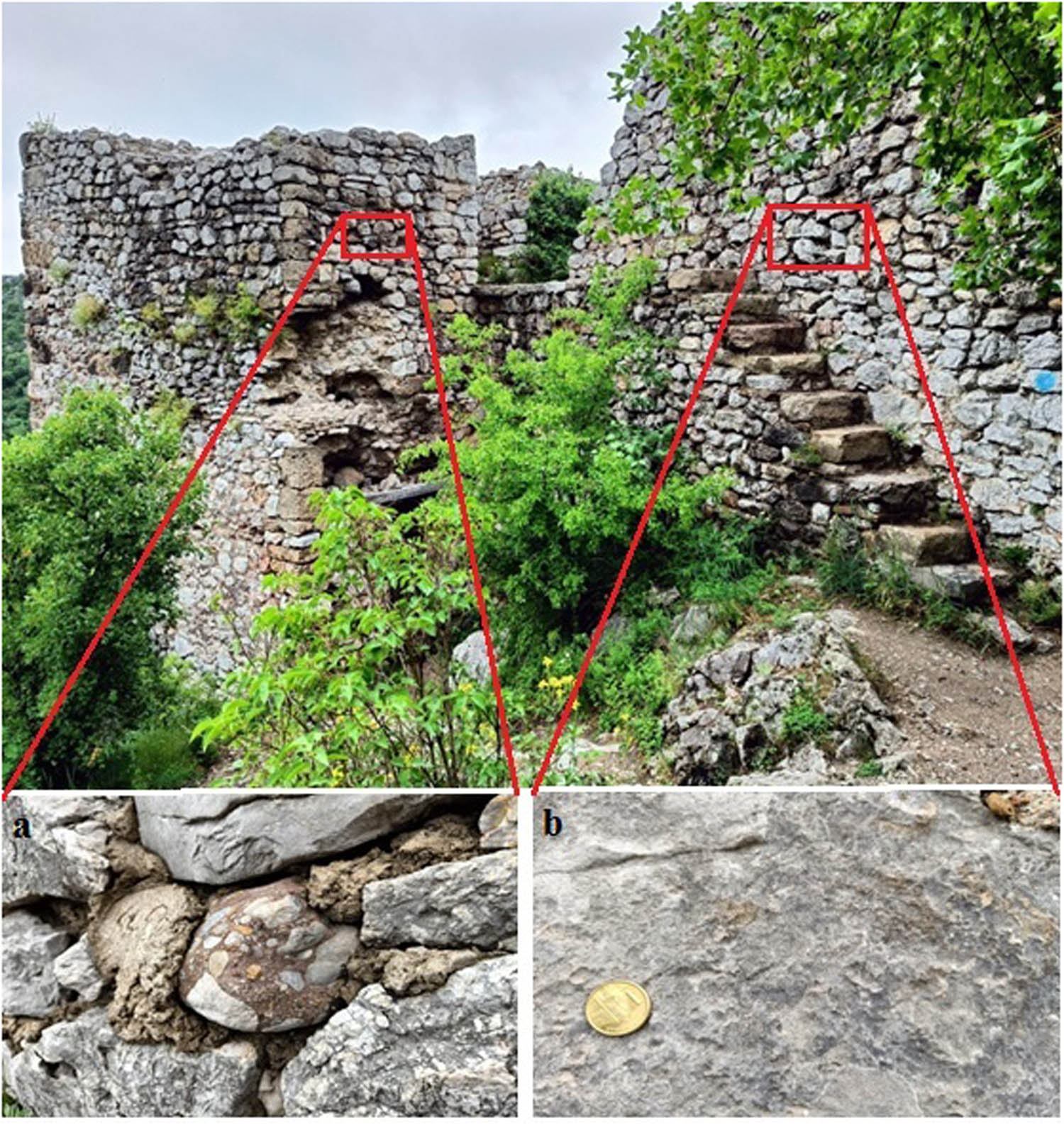
Main building stone visible on the site: (a) conglomerates built in the entrance gate and (b) limestone blocks used for the defensive walls.
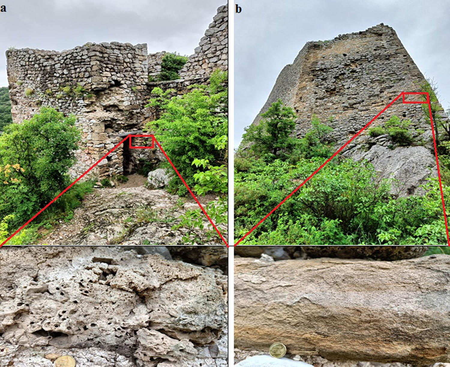
Building stone material used for the entrance gate: (a) tufa blocs with visible macro-biological components and (b) sandstone blocks used for the defensive tower.
The petrographic characteristics of the building stones at the Sokograd fortress suggest several aspects that could enhance the site’s appeal from a geotourism perspective. The site has significant petrodiversity, encompassing a range of petrographic types, which influenced the scoring of natural value indicators of the UGAM. Additionally, the area’s geotectonic evolution and the relationship between the local geology and the building materials (provenance) are notable. This information should be integrated into current archaeological interpretations and further urban geotourism development. This information also influenced the scoring of the geohistorical value subindicator of the UGAM, as it reflects the link between the geodiversity and site history; the importance of geodiversity characteristics for urban spatial development and its ability to stimulate connection with the past.
The results indicate that the petrodiversity at the Sokograd fortress includes sedimentary (limestone, sandstone, tufa, and conglomerate) rocks. The genesis of these rocks can serve as an introduction to geological processes, as inferred from the mineralogical and petrographic features (texture and fabric) of the studied rocks and their physical characteristics (hardness and density). Some rock types (e.g. sandstone) can be presented as an outdoor museum, displaying the history of their formation. The cracks on it can reveal where the sand dried out in the Sun, and bedding marks can reveal the way sand deposition changed continually period by period. These findings helped in the evaluation of the educational possibilities’ subindicator of the UGAM. This geocultural site holds value for geoscience research and education. Also, it can serve as an educational resource to illustrate fundamental geomorphological concepts to university students studying geology and geography. There are various types of research highlighting the interpretation of geoheritage (e.g. building stone), referring to rock types used as the construction material, their genesis and provenance, as well as exploitation methods, fossil presentation, characteristics (texture and structure), their use in construction, and architecture [2,17,19,35,71,72]. The interpretation could be implemented in educational geotrails [35], geocultural routes [73], or geoeducational workshops on-site to disseminate the Earth Science to the wider public [18].
4.2 UGAM analysis
The research findings are summarized in Tables 5 and 6, along with Figure 7. Analysis of the total UGAM score suggests that UGVs (137.47) and TVs (129.08) are at a moderate level, indicating that the site falls within the field U33. While Sokograd undeniably has natural values conducive to the dissemination of geoscientific knowledge, they have yet to be sufficiently enhanced to establish it as a recognizable geotourism destination.
Subindicator values given by authors for the Sokograd fortress site
| Subindicators | Values given by the authors | Im | Total values | |
|---|---|---|---|---|
| UGVs | ||||
| Scientific values | ||||
| SIUGV1 | Representativeness | 2 | 3.94 | 7.88 |
| SIUGV2 | Rarity | 2 | 3.52 | 7.04 |
| SIUGV3 | Paleo significance | 3 | 3.14 | 9.42 |
| SIUGV4 | Geohistorical values | 3 | 3.78 | 11.34 |
| SIUGV5 | Geocultural values | 4 | 4.00 | 16.00 |
| SIUGV6 | Ecological values | 4 | 3.58 | 14.32 |
| Natural values | ||||
| SIUGV7 | Aesthetic values | 2 | 4.36 | 8.72 |
| SIUGV8 | Variety of geodiversity | 4 | 2.87 | 11.48 |
| SIUGV9 | Surface | 2 | 2.45 | 4.9 |
| Protection | ||||
| SIUGV10 | Integrity | 2 | 3.78 | 7.56 |
| SIUGV11 | Protection level | 4 | 4.14 | 16.56 |
| SIUGV12 | Threats to the site | 3 | 3.25 | 9.75 |
| SIUGV13 | Carrying capacity | 4 | 3.07 | 12.28 |
| TVs | ||||
| SITV1 | Education | 5 | 4.31 | 21.55 |
| SITV2 | Accessibility | 2 | 2.74 | 5.48 |
| SITV3 | Visitor safety | 2 | 3.09 | 6.18 |
| SITV4 | Visibility | 4 | 3.83 | 15.32 |
| SITV5 | Promotional activities | 3 | 2.69 | 8.07 |
| SITV6 | Number of visitors | 2 | 2.83 | 5.66 |
| SITV7 | Informative boards | 1 | 4.00 | 4.00 |
| SITV8 | Tourguide service | 1 | 4.07 | 4.07 |
| SITV9 | Information centre | 4 | 3.69 | 14.76 |
| SITV10 | Tourist infrastructure | 2 | 4.12 | 8.24 |
| SITV11 | Accommodation | 5 | 3.43 | 17.15 |
| SITV12 | Restaurant service | 5 | 3.72 | 18.6 |
Bold values represent values of Importance factors for Serbian tourists in UGAM model. They are bold just for visual separation from other values.
Overall values of the Sokograd fortress by UGAM
| Values | Position in the UGAM matrix | ||||
|---|---|---|---|---|---|
| Urban geosite | UGVs SVa + NVa + PVa | ΣUGV | TVs | ΣTV | Field |
| Sokograd | 66.22 + 25.1 + 46.15 | 137.47 | 129.08 | 129.08 | U33 |

Position of the Sokograd fortress in the UGAM matrix.
4.2.1 UGVs
The evaluation of UGV subindicators offers insights into the current state of the site and its potential for urban geotourism development. Although its scientific values are somewhat diminished by low rarity and representativeness, the site still retains basic values despite significant degradation. This site has a local level rarity. However, it does not demonstrate the absence of heritage value, but the value is not large. The Sokograd fortress stands out due to its unique spatial–visual relationship with the surrounding area. Additionally, the site offers an attractive panoramic view of the Sokograd gorge and its surroundings. Visitors can enjoy the local landscapes, prominently featuring the mountains, gorges, caverns, and cuestas, which are easily visible from numerous observation points, reflecting the aesthetic properties of the site. Paleo significance of the site is not rated with a high score. However, there are some features important for paleo interpretation (Miocene river terrace, fossil flora, and sandstone surface). The geocultural values are rated as high. It has remnants of Roman, Byzantine, Ottoman, and Serbian cultures, showcasing the synergy between geography and human presence, along with the use of local materials in construction. The cultural value of the site is related to its name “Sokograd” (falcon fort) as this area is famous for being the training ground for the falcons in ancient times. The municipality of Sokobanja also got its name after the Sokograd. The Sokograd is linked with many historical tales, myths, and legends which attract many tourists to the site, contributing to its value. As a landmark of the city, Sokograd holds relatively high geocultural value, depicted on postcards, souvenirs, and paintings. The building materials sourced from local quarries and the construction style adapted to the area’s characteristics add to Sokograd’s aesthetic value. The rich geodiversity in the vicinity of the site, including numerous small caves and pits, thermal and mineral springs, and the Moravica River with its falls and rapids, contributes to its high rating by the model. These features attract many tourists, nature lovers, but also adventure lovers and climbers. Furthermore, the site boasts a rich petrographic diversity, crucial for Earth Science dissemination. Despite being mostly in ruins, the Sokograd fortress maintains relatively high protection values, especially in terms of subindicators level of protection and carrying capacity, earning its place on the Serbian Cultural Heritage list. The authenticity of the site and its size attract many visitors during the year without causing significant damage, thus receiving a high value in the model. The site got a medium score for the subindicator threats to the site, as there is a small possibility of a natural disaster. The site is not located in the seismically active area, and there have been no recorded landslide activities in the past few decades. However, there are threats of anthropogenic pressure, as there is evidence of vandalism on site. The suggested carrying capacity is based on the observations performed during the group visits on the site, in the period from April to May 2024. The group counted up to 35 people, and based on the authors’ opinion, a large number of visitors on the site at the moment would possibly cause the reduction of visual quality and conformity of the visitors.
The ecological values of Sokograd are also noteworthy, situated within the natural protected area of Outstanding Natural Landscape “Lepterija – Sokograd,” with many specific and rare species, and important ecosystems [74].
4.2.2 TVs
The evaluation of the TVs of the Sokograd fortress can provide insights into its potential for geotourism. Despite receiving somewhat lower scores compared to UGV, the well-preserved parts of the site, such as the tower, entrance, water reservoir, and defensive walls, offer excellent educational opportunities. There is a possibility to interpret information about geology, particularly regarding the genesis and characteristics of the building stones.
The visible construction materials of Sokograd present opportunities for educating tourists about various aspects of geology, including rock types, lithology, hardness, colour, processing methods, and their local origins. This niche segment of tourism recently gained big popularity worldwide [4,5,10,35,75,76,77,78,79,80,81], as this information is relatively easy for most tourists to understand. Currently, promotional activities for the site are limited to the regional level, primarily conducted by the Tourism Organization of Sokobanja. Using modern technologies and promotional activities (internet, social networks, event organization, etc.) will help this site to be promoted on a national or even international level [82,83,84,85,86]. Information boards, a common and cost-effective form of interpretation and promotion [87], are lacking in quality on the site, receiving a low rating. To enhance tourism development, attention should be given to increasing the number of information boards, their strategic positioning, and improving the quality and content of their illustrations, as high-quality interpretive panels hold significant importance for self-guided tours [63]. Guided tours are one of the popular methods of geoheritage interpretation that does not require significant investments. Efficient verbal interpretation is crucial for enhancing the tourist experience. High-quality and multilingual guide services are necessary to explain complex geological and geomorphological processes, as geotourists are typically looking for knowledge about these subjects. Tour guides should enhance visitors’ awareness of the importance of geoheritage and its conservation [88]. Investing in the education of tour guides about geology and geomorphology would undoubtedly lead to a more enriching tourist experience.
The information centre, located a few kilometres from the site, offers limited services to visitors, primarily providing promotional materials, souvenirs, and basic information about the history of the area. Visitor centres are an important part of the tourism destination and interpretation worldwide where tourists can communicate with the destination and participate in various educational programmes [89,90]. The existing tourism infrastructure on and near the site is of lower quality, posing a challenge for improvement, including parking areas, footpaths, rest areas, toilets, and waste disposal facilities.
Accessibility to the Sokograd fortress, situated on a high limestone ridge on the edge of the urban area, is only possible on foot, presenting safety concerns such as the risk of debris falls and slippery rocks, especially during adverse weather conditions. Installing handrails and fences would enhance the safety and encourage greater tourist activation of the site. Safety measures are effectively implemented in the geocultural site Golubac fortress, and there are zones for full access and limited access.
Effective tourism development relies on the cooperation between the local community and tourism stakeholders. Community involvement is crucial for exchanging ideas and establishing strong connections between locals, protected areas, and officials. This connection not only enhances the understanding of tourism practices among locals but also drives economic growth in the community. An illustrative instance is the Luochuan Loess National Geopark in China, where the local community received training and education to participate in tourism activities within the geopark area [91].
4.2.3 UGAM matrix
The conclusive results of the evaluation process, as presented in Table 6 and Figure 7, affirm Sokograd’s potential for urban geotourism, particularly highlighting its natural and protection values. The evaluated geosite is situated in field U 33, which means that it has medium values for both UGV and TV. Comparing the results of Sokograd fortress (UGV = 137.47; TV = 129.08) with the UGAM analysis of the geocultural site Felix Romuliana [35] (UGV = 145.78; TV = 171.78), it can be concluded that both sites are located in the field U33, but there are differences in some indicator values. The Sokograd fortress has slightly higher scientific values (especially values of paleo significance and ecological values), but the Felix Romuliana has slightly higher natural values (surface and aesthetic values) and protection values (protection level and carrying capacity). The Felix Romuliana also has significantly higher TVs, as this site is a well-known tourist attraction with developed tourism infrastructure, tour guide service, promotional activities, and information panels. Aligning with contemporary geotourism trends (educational guided tours, information boards with AR or QR codes for self-guided tours, and audio guides), modernizing its infrastructure and promotion will propel Sokograd towards becoming a recognizable urban geotourism destination in the region. With the enhancement of these elements, Sokograd’s position in the UGAM matrix could elevate to U34 or beyond.
4.3 Degradation risk analysis
The results gathered regarding the degradation risk of the geocultural site Sokograd, near Sokobanja, are outlined in Table 7. The obtained results could be useful for the future managerial plan for tourism development at the site. The findings indicate that certain geosite has a low level of susceptibility and exposure to threats (both human and natural). The Sokograd obtained a score lower than 200, which means that it is of low degradation risk. However, it is necessary to target geoconservation measures to support sustainable tourism development. There are a lot of examples [29,30,31] where over-tourism caused irreversible damage to the site due to inadequate and ineffective management. As the building stone used at Sokograd and the old Roman aqueduct are significant for Earth Science dissemination, it is important to highlight its educational and scientific value. The site itself is robust, and the building material composition has greater resilience against a variety of threats. Also, the location of the site limits the arrival of a large number of tourists, which can cause deterioration. It is important to mention that good accessibility is significant for tourism development; however, more tourists can cause more pressure on the site leading to higher degradation risk. So, the management of the destination should find the best solution to make this site easily accessible, with low degradation risk. The parking lots should be distant from the site, and a walking path of at least 1 km should lead to the destination. In the case of the Sokograd fortress, this managerial solution is feasible because of terrain physiognomy. It is also important to highlight local community involvement in tourism development; however, more people situated near the site may cause human-induced deterioration. Education of the local community and all other stakeholders about the significance of the site may raise their perception of the site’s value, so this could lead to degradation risk mitigation. According to Comer and Willems [30], archaeological sites and landscapes should be presented not as recreational parks but as museums or laboratories. It is essential for visitors to understand the fragile nature of the antiquities and have opportunities to learn and enjoy related experiences outside the sensitive areas. A visit to the site should serve as a foundation for interpretation, which should primarily occur in locations that do not contain delicate resources and where local communities are or will be established. So, the Sokograd fortress possesses values that can serve as an open air museum or laboratory, and the management should take action according to this manner. A big problem at the site is human-induced damage. Vandalism and graffiti on the site send a bad image to the public. Wilson and Kelling [92] presented the “broken window theory” referring that the visual environment provides cues that establish norms, influencing people to behave in ways that appear normal and acceptable based on their surroundings. So, the first step in the further development of tourism in the Sokograd fortress is to prevent those actions by constant monitoring of the site and establishing regulations. They [92] also referred to intrusive development, as it sends a message to all stakeholders that if intrusive development is present, other intrusive actions are also acceptable. So, future managerial plans should prevent intrusive development of tourism on the site (e.g. accommodation facilities and restaurants), as Sokograd is located in the heart of nature protected area “Lepterija-Sokograd,” and main ecological values should be preserved.
Total values of degradation risk for the geocultural site Sokograd fortress
| Degradation risk criteria | Weight | Urban geosite Sokograd | Total values |
|---|---|---|---|
| A. Deterioration of geological elements | 35 | 2 | 70 |
| B. Proximity to areas/activities with potential to cause degradation | 20 | 1 | 20 |
| C. Legal protection | 20 | 2 | 40 |
| D. Accessibility | 15 | 1 | 15 |
| E. Density of population | 10 | 1 | 10 |
| Total | 100 | 155 |
5 Conclusions
This article aimed to present the geoheritage values of the geocultural site Sokograd fortress. The UGAM for assessing the tourism potential of urban geosites provided insight into the advantages, disadvantages, limitations, and potentials of urban geotourism development at the Sokograd fortress. The UGAM parameters revealed that the Sokograd fortress has highly rated values related to geoheritage diversity and geocultural and ecological values significant for the dissemination of Earth Science. On the other hand, low values of tourism infrastructure, guide service, and information boards limit the tourism possibilities of this site. The results of degradation risk assessment provided the conclusion that further tourism development would not cause serious damage to the site, but it has to be performed with high responsibility in a sustainable way. A mineralogical–petrographical study of selected building stones at the Sokograd fortress confirmed that this site has a significant petrographical diversity of sedimentary rock types (limestone, sandstone, tufa, and conglomerates) of local provenance, which is a great opportunity for educational activities and Earth Science dissemination. As urban geotourism falls under specific types of tourism, utilizing this site for educational purposes, such as organizing field trips or workshops for students and teachers, would affect its popularity and put it on the geotouristic map of Serbia. Urban geotourism of Sokograd cannot be a significant motive for the visitors of Sokobanja, as there are many natural resources that attract a large number of visitors during the year, but it could be a complement to the existing tourism offer (ecotourism, rural tourism, and health tourism), and it could fill a gap of the geotourism offer in the future.
Acknowledgments
This research was partialy funded by Ministry of science, technological development and invoaions, Republic of Serbia (No. 451-03-65/2024-03/200124). The authors acknowledge the support of the Provincial Secretariat for Higher Education and Scientific Research of Aautonomous Province of Vojvodina, Republic of Serbia (Grant No. 142-451-3490/2023). SBM is grateful for grant F-178 of Serbian Academy of Sciences and Arts.
-
Author contributions: MM set the draft of the manuscript; RM, AM, NT helped in the interpretation of obtained results; MM, MGR, SBM, VS did field research and final appearance of the manuscript.
-
Conflict of interest: Authors state no conflict of interest.
-
Author statement: This manuscript (or one with substantially the same content, by any of the authors) has not been previously published in any language anywhere and that it is not under simultaneous consideration or in press by another journal.
References
[1] Brilha J. Inventory and quantitative assessment of geosites and geodiversity sites: a review. Geoheritage. 2016;8(2):119–34.10.1007/s12371-014-0139-3Search in Google Scholar
[2] Del Lama EA, de La Corte Bacci D, Martins L, da Glória Motta Garcia M, Dehira LK. Urban geotourism and the old centre of São Paulo City, Brazil. Geoheritage. 2015;7(2):147–64.10.1007/s12371-014-0119-7Search in Google Scholar
[3] Del Lama EA. Potential for urban geotourism: churches and cemeteries. Geoheritage. 2019;11(3):717–28.10.1007/s12371-018-0325-9Search in Google Scholar
[4] Palacio-Prieto JL. Geoheritage within cities: urban geosites in Mexico City. Geoheritage. 2015;7(4):365–73.10.1007/s12371-014-0136-6Search in Google Scholar
[5] Kubalíková L, Kirchner K, Kuda F, Bajer A. Assessment of urban geotourism resources: an example of two geocultural sites in Brno, Czech Republic. Geoheritage. 2020;12(1):1–12.10.1007/s12371-020-00434-xSearch in Google Scholar
[6] Kubalíková L, Drápela E, Kirchner K, Bajer A, Balková M, Kuda F. Urban geotourism development and geoconservation: Is it possible to find a balance? Environ Sci Policy. 2021;121:1–10.10.1016/j.envsci.2021.03.016Search in Google Scholar
[7] Pica A, Vergari F, Fredi P, Del Monte M. The aeterna urbs geomorphological heritage (Rome, Italy). Geoheritage. 2016;8:31–42.10.1007/s12371-015-0150-3Search in Google Scholar
[8] Pica A, Luberti GM, Vergari F, Fredi P, Del Monte M. Contribution for an urban geomorphoheritage assessment method: proposal from three geomorphosites in Rome (Italy). Quaest Geographicae. 2017;36(3):21–36.10.1515/quageo-2017-0030Search in Google Scholar
[9] Chylińska D, Kołodziejczyk K. Geotourism in an urban space? Open Geosci. 2018;10(1):297–310.10.1515/geo-2018-0023Search in Google Scholar
[10] Habibi T, Ponedelnik AA, Yashalova NN, Ruban DA. Urban geoheritage complexity: Evidence of a unique natural resource from Shiraz city in Iran. Resour Policy. 2018;59:85–94.10.1016/j.resourpol.2018.06.002Search in Google Scholar
[11] Silva REC, Polck MAR, de Araújo-Júnior HI. Geodiversity in ecclesiastical construction: a geotourism itinerary in the City of Rio de Janeiro. Geoheritage. 2024;16(1):9.10.1007/s12371-023-00912-ySearch in Google Scholar
[12] Quesada-Valverde ME, Quesada-Román A. Worldwide trends in methods and resources promoting geoconservation, geotourism, and geoheritage. Geosciences. 2023;13(2):39.10.3390/geosciences13020039Search in Google Scholar
[13] Reynard E, Pica A, Coratza P. Urban geomorphological heritage. An overview. Quaest Geogr. 2017;36(3):7–20.10.1515/quageo-2017-0022Search in Google Scholar
[14] Kramar S, Bedjanič M, Mirtič B, Mladenović A, Rožič B, Skaberne D, et al. Podpeč limestone: a heritage stone from Slovenia. Geol Soc, London, Spec Publ. 2015;407(1):219–31.10.1144/SP407.2Search in Google Scholar
[15] da Silva CM. Urban geodiversity and decorative arts: the curious case of the “Rudist Tiles” of Lisbon (Portugal). Geoheritage. 2019;11(1):151–63.10.1007/s12371-017-0253-0Search in Google Scholar
[16] Zoghlami K, Martín-Martín JD, Gomez-Gras D, Navarro A, Parcerisa D, Rosell JR. The building stone of the Roman city of Dougga (Tunisia): Provenance, petrophysical characterisation and durability. Comptes Rendus Geosci. 2017;349(8):402–11.10.1016/j.crte.2017.09.017Search in Google Scholar
[17] Fio Firi K, Maričić A. Usage of the natural stones in the City of Zagreb (Croatia) and its geotouristical aspect. Geoheritage. 2020;12:62. 10.1007/s12371-020-00488-x.Search in Google Scholar
[18] Melelli L. “Perugia upside-down”: a multimedia exhibition in Umbria (Central Italy) for improving geoheritage and geotourism in urban areas. Resources. 2020;8(3):148.10.3390/resources8030148Search in Google Scholar
[19] Melelli L, Silvani F, Ercoli M, Pauselli C, Tosi G, Radicioni F. Urban geology for the enhancement of the hypogean geosites: The Perugia underground (Central Italy). Geoheritage. 2021;13(1):1–20.10.1007/s12371-021-00545-zSearch in Google Scholar
[20] Reynard E, Giusti C. The landscape and the cultural value of geoheritage. In: Reynard E, Brilha J, editors. Geoheritage: Assessment, protection, and management. Amsterdam, The Netherlands: Elsevier; 2018. p. 147–65.10.1016/B978-0-12-809531-7.00008-3Search in Google Scholar
[21] Kubalíková L, Zapletalová D. Geo-cultural aspects of building stone extracted within Brno city (Czech Republic): A bridge between natural and cultural heritage. Geoheritage. 2021;13(3):78.10.1007/s12371-021-00585-5Search in Google Scholar
[22] Cardona OD, Van Aalst MK, Birkmann J, Fordham M, Mc Gregor G, Rosa P, et al. Determinants of risk: Exposure and vulnerability. In: Field CB, Barros V, Stocker TF, Qin D, Dokken DJ, Ebi KL, et al., editors. Managing the risks of extreme events and disasters to advance climate change adaptation: Special report of the intergovernmental panel on climate change. Cambridge: Cambridge University Press; 2012. p. 65–108. 10.1017/CBO9781139177245.005.Search in Google Scholar
[23] García-Ortiz E, Fuertes-Gutiérrez I, Fernández-Martínez E. Concepts and terminology for the risk of degradation of geological heritage sites: Fragility and natural vulnerability, a case study. Proc Geol Assoc. 2014;125(4):463–79. 10.1016/J.PGEOLA.2014.06.003.Search in Google Scholar
[24] Gordon JE, Wignall RML, Brazier V, Crofts R, Tormey D. Planning for climate change impacts on geoheritage interests in protected and conserved areas. Geoheritage. 2022;14(4):126. 10.1007/S12371-022-00753-1/TABLES/3.Search in Google Scholar
[25] Selmi L, Canesin TS, Gauci R, Pereira P, Coratza P. Degradation risk assessment: Understanding the impacts of climate change on geoheritage. Sustainability. 2022;14(7):4262. 10.3390/SU14074262.Search in Google Scholar
[26] Morino C, Coratza P, Soldati M. Landslides, a key landform in the global geological heritage. Front Earth Sci. 2022;10:864760. 10.3389/FEART.2022.864760/BIBTEX.Search in Google Scholar
[27] Papp DC. Geological heritage in the Northern Apuseni Mountains (Romania): Degradation risk assessment of selected geosites. Int J Geoheritage Park. 2023;11(4):574–91.10.1016/j.ijgeop.2023.10.001Search in Google Scholar
[28] Fuertes-Gutiérrez I, Fernández-Martínez E. Geosites inventory in the Leon Province (Northwestern Spain): A tool to introduce geoheritage into regional environmental management. Geoheritage. 2010;2(1):57–75. 10.1007/s12371-010-0012-y.Search in Google Scholar
[29] Comer D. Tourism and Archaeological Heritage Management at Petra. N Y: Springer-Verlag; 2012. p. 131–44.Search in Google Scholar
[30] Comer CD, Willems WJH. Tourism and the archaeological heritage: driver to development or destruction? ICOMOS 17th General Assembly. Paris, France: 2012.10.1007/978-1-4614-1481-0Search in Google Scholar
[31] Coccossis H. Sustainable Development and Tourism: Opportunities and Threats to Cultural Heritage from Tourism. In: Fusco Girard L, Nijkamp P, editors. Cultural tourism and sustainable local development. Farnham, UK; Burlington, VT, USA: Ashgate Publishing; 2009. p. 47–56.Search in Google Scholar
[32] Bratić M, Marjanović M, Radivojević AR, Pavlović M. M-GAM method in function of tourism potential assessment: Case study of the Sokobanja basin in eastern Serbia. Open Geosci. 2020;12(1):1468–85.10.1515/geo-2020-0116Search in Google Scholar
[33] Marjanović M. Geoturizam Zaječarskog okruga (Geotourism of Zaječar district). PhD thesis. Serbia: University of Novi Sad; 2024.Search in Google Scholar
[34] Radivojević A. Geografske promene u Sokobanjskoj kotlini i njihov uticaj na regionalni razvoj (Geographical changes in Sokobanja valley and their impact on regional development). PhD thesis. Serbia: University of Belgrade. 2008.Search in Google Scholar
[35] Marjanović M, Marković R, Šarić K, Radivojević AR, Antić A, Raičević Đ, et al. Geotouristic Approach to the elements of geocultural heritage by using UGAM Model: UNESCO World Heritage Site Felix Romuliana (Zaječar, Serbia). Geoheritage. 2024;16(2):1–21.10.1007/s12371-024-00940-2Search in Google Scholar
[36] Ghorbani S, Hoseinie SH, Ghasemi E, Sherizadeh T. A review on rock hardness testing methods and their applications in rock engineering. Arab J Geosci. 2022;15(11):1067.10.1007/s12517-022-10314-zSearch in Google Scholar
[37] Anđelković J, Krstić B, Bogdanović P, Jadranin D, Milenković P, Milošaković R, et al. Explanatory book for sheet Pirot and Brezni. Basic geological map 1:100 000. Federal geological survey. Belgrade. 1969;1–69.Search in Google Scholar
[38] Maslarevic L, Krstic B. Continental permian and lower triassic red beds of the serbian carpatho-balkanides. In Permian continental deposits of Europe and other areas. Regional reports and correlations. Mus Civico di Sci Naturali di Brescia. 2001;25:245–52.Search in Google Scholar
[39] Cvetkovic V, Prelević D, Schmid S. Geology of south-eastern Europe. In: Papic P, editor. Mineral and thermal waters of Southeastern Europe. Environmental earth sciences book series. Cham: Springer International Publishing; 2016. p. 1–29.10.1007/978-3-319-25379-4_1Search in Google Scholar
[40] Seghedi A. The North Dobrogea orogenic belt (Romania). A review. In: Ziegler PA, Cavazza W, Robertson A, Crasquin-Soleau S, editors. Peri-Tethys Memoir 6, Peri-Tethyan Rift/Wrench Basins and Passive Margins. Paris: Editions du Muséum; 2021.Search in Google Scholar
[41] Karamata S. The geodynamical framework of the Balkan Peninsula: its origin due to the approach, collision and compression of Gondwanian and Eurasian units. In: Robertson AHF, Mountrakis D, editors. Tectonic Development of the Eastern Mediterranean Region. Vol. 260, Geological Society, London: Special Publications; 2006. p. 155–78.10.1144/GSL.SP.2006.260.01.07Search in Google Scholar
[42] Schmid S, Bernoulli D, Fugenschuh B, Matenco L, Schefer S, Schuster R, et al. The Alpine-Carpathian-Dinaride orogenic system: correlation and evolution of tectonic units. Swiss J Geosci. 2008;101:139–83.10.1007/s00015-008-1247-3Search in Google Scholar
[43] Jovanović SP. Geomorfologija Sokobanjske kotline (Geography of Sokobanja valley). Bull Serbian Geol Soc. 1923;9:59–82.Search in Google Scholar
[44] Krstić B, Veselinović M, Divljan M, Rakić M. Explanatory book for sheet Aleksinac. Basic geological map 1:100 000. Federal geological survey. Belgrade. 1974;1–59.Search in Google Scholar
[45] Krstić B, Kalenić M, Divljan M, Maslarević LJ, Đorđević M, Dolić D, et al. Explanatory book for sheet Knjaževac and Belogradčik. Basic geological map 1:100 000. Federal geological survey. Belgrade. 1969;1–78.Search in Google Scholar
[46] RS Official Gazette SRS 14/79 (https://pravno-informacionisistem.rs/eli/rep/sgsrs/skupstina/odluka/1979/14/1/reg). Accessed on 20.05.2024.Search in Google Scholar
[47] Rusić V, Veljović M. Sokobanja i srez banjski (Sokobanja and its community). Niš: Historical archive of Niš; 1982.Search in Google Scholar
[48] Reynard E. Scientific research and tourist promotion of geomorphological heritage. Geogr Fis e dinamica Quaternaria. 2008;31:225–30.Search in Google Scholar
[49] Suzuki DA, Takagi H. Evaluation of geosite for sustainable planning and management in geotourism. Geoheritage. 2018;10:123–35.10.1007/s12371-017-0225-4Search in Google Scholar
[50] Carrión-Mero P, Herrera Franco G, Briones J, Caldevilla P, Domínguez-Cuesta MJ, Berrezueta E. Geotourism and local development based on geological and mining sites utilization, Zaruma-Portovelo, Ecuador. Geosciences. 2018;8(6):205.10.3390/geosciences8060205Search in Google Scholar
[51] Herrera-Franco GA, Carrión-Mero P, Mora-Frank C, Caicedo-Potosí J. Comparative analysis of methodologies for the evaluation of geosites in the context of the Santa Elena-Ancón geopark project. Int J Des Nat Ecodyn. 2020;15(2):183–8.10.18280/ijdne.150207Search in Google Scholar
[52] Kot R. The point bonitation method for evaluating geodiversity: a guide with examples (Polish Lowland). Geografiska Annaler: Series A. Phys Geogr. 2015;97(2):375–93.10.1111/geoa.12079Search in Google Scholar
[53] Ruban DA. Quantification of geodiversity and its loss. Proc Geol Assoc. 2010;121:326–33.10.1016/j.pgeola.2010.07.002Search in Google Scholar
[54] Melelli L. Geodiversity: a new quantitative index for natural protected areas enhancement. Geoj Tour geosites. 2014;13(1):27–37.Search in Google Scholar
[55] Forte JP, Brilha J, Pereira DI, Nolasco M. Kernel density applied to the quantitative assessment of geodiversity. Geoheritage. 2018;10:205–17.10.1007/s12371-018-0282-3Search in Google Scholar
[56] Tomić N. The potential of Lazar Canyon (Serbia) as a geotourism destination: inventory and evaluation. Geogr Pannonica. 2011;15(3):103–12.10.5937/GeoPan1103103TSearch in Google Scholar
[57] Kubalíková L, Kirchner K. Geosite and geomorphosite assessment as a tool for geoconservation and geotourism purposes: a case study from Vizovická vrchovina Highland (eastern part of the Czech Republic). Geoheritage. 2016;8(1):5–14.10.1007/s12371-015-0143-2Search in Google Scholar
[58] Mikhailenko AV, Nazarenko OV, Ruban DA, Zayats PP. Aesthetics- based classification of geological structures in outcrops for geotourism purposes: a tentative proposal. Geologos. 2017;23:45–52.10.1515/logos-2017-0004Search in Google Scholar
[59] Tomić N, Božić S. A modified geosite assessment model (MGAM) and its application on the Lazar Canyon area (Serbia). Int J Env Res. 2014;8(4):1041–52.Search in Google Scholar
[60] Marjanović M, Tomić N, Radivojević AR, Marković SB. Assessing the geotourism potential of the Niš city area (Southeast Serbia). Geoheritage. 2021;13:1–18.10.1007/s12371-021-00597-1Search in Google Scholar
[61] Antić A, Tomić N, Marković SB. Applying the show cave assessment model (SCAM) on cave tourism destinations in Serbia. Int J Geoheritage Park. 2022;10(4):616–34.10.1016/j.ijgeop.2022.10.001Search in Google Scholar
[62] Marjanović M, Radivojević AR, Antić A, Peppoloni S, Di Capua G, Lazarević J, et al. Geotourism and geoethics as support for rural development in the Knjaževac municipality, Serbia. Open Geosci. 2022;14(1):794–812.10.1515/geo-2022-0388Search in Google Scholar
[63] Antić A, Radaković MG, Marjanović M, Marković SB, Perić ZM, Spalević V, et al. Loess and geotourism potential of the Braničevo District (NE Serbia): From overexploitation to paleoclimate interpretation. Open Geosci. 2023;15(1):20220546.10.1515/geo-2022-0546Search in Google Scholar
[64] Brilha J. Património Geológico e Geoconservação: a Conservação da Natureza na sua Vertente Geológica. Viseu: Palimage Editores; 2005.Search in Google Scholar
[65] Carcavilla L, Durán JJ, Garcia-Cortés A, López-Martinez J. Geological heritage and geoconservation in Spain: past, present, and future. Geoheritage. 2009;1(2–4):75–91.10.1007/s12371-009-0006-9Search in Google Scholar
[66] Reynard E, Fontana G, Kozlik L, Scapozza C. A method for assessing “scientific” and “additional values” of geomorphosites. Geogr Hel Jg 62 Heft. 2007;3:148–58.10.5194/gh-62-148-2007Search in Google Scholar
[67] García-Cortés A, Carcavilla Urquí L. Documento metodológico para la elaboración del inventario español de lugares de interés geológico (IELIG), version 12. España, Madrid; Instituto Geológico y Minero de; 2009.Search in Google Scholar
[68] Lima FF, Brilha JB, Salamuni E. Inventorying geological heritage in large territories: a methodological proposal applied to Brazil. Geoheritage. 2010;2(3–4):91–9.10.1007/s12371-010-0014-9Search in Google Scholar
[69] Pereira P, Pereira DI. Methodological guidelines for geomorphosite assessment. Géomorphol Relief, Processus Environ. 2010;2:215–22.10.4000/geomorphologie.7942Search in Google Scholar
[70] Fassoulas C, Mouriki D, Dimitriou-Nikolakis P, Iliopoulos G. Quantitative assessment of geotopes as an effective tool for geoheritage management. Geoheritage. 2012;4(3):177–93.10.1007/s12371-011-0046-9Search in Google Scholar
[71] Kong W, Li Y, Li K, Chen M, Peng Y, Wang D, et al. Urban geoheritage sites under strong anthropogenic pressure: example from the chaohu Lake Region, Hefei, China. Geoheritage. 2020;12(3):1–24.10.1007/s12371-020-00490-3Search in Google Scholar
[72] Zoboli D, Pistis M, Afrasinei GM, Nonnoi G, Pillola GL. Crocodiles, sharks and turtles: The urban geo-palaeontological heritage of Cagliari (Italy). Geoheritage. 2021;13(3):52.10.1007/s12371-021-00580-wSearch in Google Scholar
[73] Antić A, Tomić N, Đorđević T, Marković SB. Promoting palaeontological heritage of mammoths in Serbia through a cross-country thematic route. Geoheritage. 2021;13:1–16.10.1007/s12371-021-00530-6Search in Google Scholar
[74] Ranđelović N, Avramović D. Protected nature areas, flora and vegetation in vicinity of Sokobanja (Serbia and Montenegro). Nat Montenegrina Podgor. 2004;3:379–86.Search in Google Scholar
[75] Petrović MD, Lukić DM, Radovanović M, Vujko A, Gajić T, Vuković D. “Urban geosites” as an alternative geotourism destination- evidence from Belgrade. Open Geosci. 2017;9(1):442–56.10.1515/geo-2017-0034Search in Google Scholar
[76] Tičar J, Komac B, Zorn M, Ferk M, Hrvatin M, Ciglič R. From urban geodiversity to geoheritage: the case of Ljubljana (Slovenia). Quaest Geographicae. 2017;36:37–50.10.1515/quageo-2017-0023Search in Google Scholar
[77] Freire-Lista DM, Sousa L, Carter R, Al-Na imi F. Petrographic and Petrophysical Characterisation of the Heritage Stones of Fuwairit Archaeological Site (NE Qatar) and their Historical Quarries: Implications for Heritage Conservation. Episodes. 2021;44(1):43–58.10.18814/epiiugs/2020/0200s12Search in Google Scholar
[78] Penn-Clarke CR, Deacon J, Wiltshire N, Browning C, du Plessis R. Short report: Geoheritage in the Matjiesrivier Nature Reserve, a World Heritage Site in the Cederberg, South Africa. J Afr Earth Sc. 2020;166:103818.10.1016/j.jafrearsci.2020.103818Search in Google Scholar
[79] Das A, Sodhi A, Vedpathak C, Ambekar A, Prizomwala SP. Assessment of Geoheritage and Geotoursim Potential of the Geoarchaeosites from the Mainland Gujarat. West India Geoheritage. 2022;14(4):1–14.10.1007/s12371-022-00768-8Search in Google Scholar
[80] Cocean G, Cocean P. An assessment of gorges for purposes of identifying geomorphosites of geotourism value in the Apuseni Mountains (Romania). Geoheritage. 2016;9(1):71–81.10.1007/s12371-016-0180-5Search in Google Scholar
[81] Moradipour F, Moghimi E, Beglou MJ, Yamani M. Assessment of urban geomorphological heritage for urban geotourism development in Khorramabad City, Iran. Geoheritage. 2020;12:1–20.10.1007/s12371-020-00466-3Search in Google Scholar
[82] Marinoni O. Implementation of the analytical hierarchy process with VBA in ArcGIS. Comput Geosci. 2004;30(6):637–46.10.1016/j.cageo.2004.03.010Search in Google Scholar
[83] Reynard E, Kaiser C, Martin S, Regolini G. An application for Geosciences communication by smartphones and tablets. In Engineering Geology for Society and Territory-Volume 8: Preservation of Cultural Heritage. Switzerland: Springer International Publishing; 2015. p. 265–8.10.1007/978-3-319-09408-3_46Search in Google Scholar
[84] Gambino F, Borghi A, d’Atri A, Gallo LM, Ghiraldi L, Giardino M, et al. TOURin-STONES: a free mobile application for promoting geological heritage in the city of Torino (NW Italy). Geoheritage. 2019;11:3–17.10.1007/s12371-017-0277-5Search in Google Scholar
[85] Filocamo F, Di Paola G, Mastrobuono L, Rosskopf CM. MoGeo, a mobile application to promote geotourism in molise region (southern Italy). Resources. 2020;9(3):31. 10.3390/resources9 030031.Search in Google Scholar
[86] Perotti L, Bollati IM, Viani C, Zanoletti E, Caironi V, Pelfini M, et al. Fieldtrip and virtual tours as geotourism resources: example from the Sesia Val Grande UNESCO Global Geopark (NW Italy). Resources. 2020;9(6):63. 10.3390/resou rces9 060063.Search in Google Scholar
[87] Bruno BC, Wallace A. Interpretive panels for geoheritage sites: Guidelines for design and evaluation. Geoheritage. 2019;11:1315–23. 10.1007/s12371-019-00375-0.Search in Google Scholar
[88] Hose TA. Geotrails. Geotourism In 21st Century. New York, USA: Apple Academic Press; 2020. p. 247–75.10.1201/9780429292798-13Search in Google Scholar
[89] Newsome D, Dowling R. The scope and nature of geotourism. Geotourism. London, UK: Routledge; 2006. p. 3–25.10.1016/B978-0-7506-6215-4.50009-9Search in Google Scholar
[90] Pearce PL, Moscardo G. An action research appraisal of visitor center interpretation and change. J Interpret Res. 2007;12(1):29–50.10.1177/109258720701200103Search in Google Scholar
[91] Dong H, Song Y, Chen T, Zhao J, Yu L. Geoconservation and geotourism in Luochuan loess national geopark, China. Quat Int. 2014;334:40–51.10.1016/j.quaint.2013.10.023Search in Google Scholar
[92] Wilson JQ, Kelling GL. Broken windows. Atlantic Monthly (1982). In The city reader. London, UK: Routledge; 2011. p. 309–19.Search in Google Scholar
© 2024 the author(s), published by De Gruyter
This work is licensed under the Creative Commons Attribution 4.0 International License.
Articles in the same Issue
- Regular Articles
- Theoretical magnetotelluric response of stratiform earth consisting of alternative homogeneous and transitional layers
- The research of common drought indexes for the application to the drought monitoring in the region of Jin Sha river
- Evolutionary game analysis of government, businesses, and consumers in high-standard farmland low-carbon construction
- On the use of low-frequency passive seismic as a direct hydrocarbon indicator: A case study at Banyubang oil field, Indonesia
- Water transportation planning in connection with extreme weather conditions; case study – Port of Novi Sad, Serbia
- Zircon U–Pb ages of the Paleozoic volcaniclastic strata in the Junggar Basin, NW China
- Monitoring of mangrove forests vegetation based on optical versus microwave data: A case study western coast of Saudi Arabia
- Microfacies analysis of marine shale: A case study of the shales of the Wufeng–Longmaxi formation in the western Chongqing, Sichuan Basin, China
- Multisource remote sensing image fusion processing in plateau seismic region feature information extraction and application analysis – An example of the Menyuan Ms6.9 earthquake on January 8, 2022
- Identification of magnetic mineralogy and paleo-flow direction of the Miocene-quaternary volcanic products in the north of Lake Van, Eastern Turkey
- Impact of fully rotating steel casing bored pile on adjacent tunnels
- Adolescents’ consumption intentions toward leisure tourism in high-risk leisure environments in riverine areas
- Petrogenesis of Jurassic granitic rocks in South China Block: Implications for events related to subduction of Paleo-Pacific plate
- Differences in urban daytime and night block vitality based on mobile phone signaling data: A case study of Kunming’s urban district
- Random forest and artificial neural network-based tsunami forests classification using data fusion of Sentinel-2 and Airbus Vision-1 satellites: A case study of Garhi Chandan, Pakistan
- Integrated geophysical approach for detection and size-geometry characterization of a multiscale karst system in carbonate units, semiarid Brazil
- Spatial and temporal changes in ecosystem services value and analysis of driving factors in the Yangtze River Delta Region
- Deep fault sliding rates for Ka-Ping block of Xinjiang based on repeating earthquakes
- Improved deep learning segmentation of outdoor point clouds with different sampling strategies and using intensities
- Platform margin belt structure and sedimentation characteristics of Changxing Formation reefs on both sides of the Kaijiang-Liangping trough, eastern Sichuan Basin, China
- Enhancing attapulgite and cement-modified loess for effective landfill lining: A study on seepage prevention and Cu/Pb ion adsorption
- Flood risk assessment, a case study in an arid environment of Southeast Morocco
- Lower limits of physical properties and classification evaluation criteria of the tight reservoir in the Ahe Formation in the Dibei Area of the Kuqa depression
- Evaluation of Viaducts’ contribution to road network accessibility in the Yunnan–Guizhou area based on the node deletion method
- Permian tectonic switch of the southern Central Asian Orogenic Belt: Constraints from magmatism in the southern Alxa region, NW China
- Element geochemical differences in lower Cambrian black shales with hydrothermal sedimentation in the Yangtze block, South China
- Three-dimensional finite-memory quasi-Newton inversion of the magnetotelluric based on unstructured grids
- Obliquity-paced summer monsoon from the Shilou red clay section on the eastern Chinese Loess Plateau
- Classification and logging identification of reservoir space near the upper Ordovician pinch-out line in Tahe Oilfield
- Ultra-deep channel sand body target recognition method based on improved deep learning under UAV cluster
- New formula to determine flyrock distance on sedimentary rocks with low strength
- Assessing the ecological security of tourism in Northeast China
- Effective reservoir identification and sweet spot prediction in Chang 8 Member tight oil reservoirs in Huanjiang area, Ordos Basin
- Detecting heterogeneity of spatial accessibility to sports facilities for adolescents at fine scale: A case study in Changsha, China
- Effects of freeze–thaw cycles on soil nutrients by soft rock and sand remodeling
- Vibration prediction with a method based on the absorption property of blast-induced seismic waves: A case study
- A new look at the geodynamic development of the Ediacaran–early Cambrian forearc basalts of the Tannuola-Khamsara Island Arc (Central Asia, Russia): Conclusions from geological, geochemical, and Nd-isotope data
- Spatio-temporal analysis of the driving factors of urban land use expansion in China: A study of the Yangtze River Delta region
- Selection of Euler deconvolution solutions using the enhanced horizontal gradient and stable vertical differentiation
- Phase change of the Ordovician hydrocarbon in the Tarim Basin: A case study from the Halahatang–Shunbei area
- Using interpretative structure model and analytical network process for optimum site selection of airport locations in Delta Egypt
- Geochemistry of magnetite from Fe-skarn deposits along the central Loei Fold Belt, Thailand
- Functional typology of settlements in the Srem region, Serbia
- Hunger Games Search for the elucidation of gravity anomalies with application to geothermal energy investigations and volcanic activity studies
- Addressing incomplete tile phenomena in image tiling: Introducing the grid six-intersection model
- Evaluation and control model for resilience of water resource building system based on fuzzy comprehensive evaluation method and its application
- MIF and AHP methods for delineation of groundwater potential zones using remote sensing and GIS techniques in Tirunelveli, Tenkasi District, India
- New database for the estimation of dynamic coefficient of friction of snow
- Measuring urban growth dynamics: A study in Hue city, Vietnam
- Comparative models of support-vector machine, multilayer perceptron, and decision tree predication approaches for landslide susceptibility analysis
- Experimental study on the influence of clay content on the shear strength of silty soil and mechanism analysis
- Geosite assessment as a contribution to the sustainable development of Babušnica, Serbia
- Using fuzzy analytical hierarchy process for road transportation services management based on remote sensing and GIS technology
- Accumulation mechanism of multi-type unconventional oil and gas reservoirs in Northern China: Taking Hari Sag of the Yin’e Basin as an example
- TOC prediction of source rocks based on the convolutional neural network and logging curves – A case study of Pinghu Formation in Xihu Sag
- A method for fast detection of wind farms from remote sensing images using deep learning and geospatial analysis
- Spatial distribution and driving factors of karst rocky desertification in Southwest China based on GIS and geodetector
- Physicochemical and mineralogical composition studies of clays from Share and Tshonga areas, Northern Bida Basin, Nigeria: Implications for Geophagia
- Geochemical sedimentary records of eutrophication and environmental change in Chaohu Lake, East China
- Research progress of freeze–thaw rock using bibliometric analysis
- Mixed irrigation affects the composition and diversity of the soil bacterial community
- Examining the swelling potential of cohesive soils with high plasticity according to their index properties using GIS
- Geological genesis and identification of high-porosity and low-permeability sandstones in the Cretaceous Bashkirchik Formation, northern Tarim Basin
- Usability of PPGIS tools exemplified by geodiscussion – a tool for public participation in shaping public space
- Efficient development technology of Upper Paleozoic Lower Shihezi tight sandstone gas reservoir in northeastern Ordos Basin
- Assessment of soil resources of agricultural landscapes in Turkestan region of the Republic of Kazakhstan based on agrochemical indexes
- Evaluating the impact of DEM interpolation algorithms on relief index for soil resource management
- Petrogenetic relationship between plutonic and subvolcanic rocks in the Jurassic Shuikoushan complex, South China
- A novel workflow for shale lithology identification – A case study in the Gulong Depression, Songliao Basin, China
- Characteristics and main controlling factors of dolomite reservoirs in Fei-3 Member of Feixianguan Formation of Lower Triassic, Puguang area
- Impact of high-speed railway network on county-level accessibility and economic linkage in Jiangxi Province, China: A spatio-temporal data analysis
- Estimation model of wild fractional vegetation cover based on RGB vegetation index and its application
- Lithofacies, petrography, and geochemistry of the Lamphun oceanic plate stratigraphy: As a record of the subduction history of Paleo-Tethys in Chiang Mai-Chiang Rai Suture Zone of Thailand
- Structural features and tectonic activity of the Weihe Fault, central China
- Application of the wavelet transform and Hilbert–Huang transform in stratigraphic sequence division of Jurassic Shaximiao Formation in Southwest Sichuan Basin
- Structural detachment influences the shale gas preservation in the Wufeng-Longmaxi Formation, Northern Guizhou Province
- Distribution law of Chang 7 Member tight oil in the western Ordos Basin based on geological, logging and numerical simulation techniques
- Evaluation of alteration in the geothermal province west of Cappadocia, Türkiye: Mineralogical, petrographical, geochemical, and remote sensing data
- Numerical modeling of site response at large strains with simplified nonlinear models: Application to Lotung seismic array
- Quantitative characterization of granite failure intensity under dynamic disturbance from energy standpoint
- Characteristics of debris flow dynamics and prediction of the hazardous area in Bangou Village, Yanqing District, Beijing, China
- Rockfall mapping and susceptibility evaluation based on UAV high-resolution imagery and support vector machine method
- Statistical comparison analysis of different real-time kinematic methods for the development of photogrammetric products: CORS-RTK, CORS-RTK + PPK, RTK-DRTK2, and RTK + DRTK2 + GCP
- Hydrogeological mapping of fracture networks using earth observation data to improve rainfall–runoff modeling in arid mountains, Saudi Arabia
- Petrography and geochemistry of pegmatite and leucogranite of Ntega-Marangara area, Burundi, in relation to rare metal mineralisation
- Prediction of formation fracture pressure based on reinforcement learning and XGBoost
- Hazard zonation for potential earthquake-induced landslide in the eastern East Kunlun fault zone
- Monitoring water infiltration in multiple layers of sandstone coal mining model with cracks using ERT
- Study of the patterns of ice lake variation and the factors influencing these changes in the western Nyingchi area
- Productive conservation at the landslide prone area under the threat of rapid land cover changes
- Sedimentary processes and patterns in deposits corresponding to freshwater lake-facies of hyperpycnal flow – An experimental study based on flume depositional simulations
- Study on time-dependent injectability evaluation of mudstone considering the self-healing effect
- Detection of objects with diverse geometric shapes in GPR images using deep-learning methods
- Behavior of trace metals in sedimentary cores from marine and lacustrine environments in Algeria
- Spatiotemporal variation pattern and spatial coupling relationship between NDVI and LST in Mu Us Sandy Land
- Formation mechanism and oil-bearing properties of gravity flow sand body of Chang 63 sub-member of Yanchang Formation in Huaqing area, Ordos Basin
- Diagenesis of marine-continental transitional shale from the Upper Permian Longtan Formation in southern Sichuan Basin, China
- Vertical high-velocity structures and seismic activity in western Shandong Rise, China: Case study inspired by double-difference seismic tomography
- Spatial coupling relationship between metamorphic core complex and gold deposits: Constraints from geophysical electromagnetics
- Disparities in the geospatial allocation of public facilities from the perspective of living circles
- Research on spatial correlation structure of war heritage based on field theory. A case study of Jinzhai County, China
- Formation mechanisms of Qiaoba-Zhongdu Danxia landforms in southwestern Sichuan Province, China
- Magnetic data interpretation: Implication for structure and hydrocarbon potentiality at Delta Wadi Diit, Southeastern Egypt
- Deeply buried clastic rock diagenesis evolution mechanism of Dongdaohaizi sag in the center of Junggar fault basin, Northwest China
- Application of LS-RAPID to simulate the motion of two contrasting landslides triggered by earthquakes
- The new insight of tectonic setting in Sunda–Banda transition zone using tomography seismic. Case study: 7.1 M deep earthquake 29 August 2023
- The critical role of c and φ in ensuring stability: A study on rockfill dams
- Evidence of late quaternary activity of the Weining-Shuicheng Fault in Guizhou, China
- Extreme hydroclimatic events and response of vegetation in the eastern QTP since 10 ka
- Spatial–temporal effect of sea–land gradient on landscape pattern and ecological risk in the coastal zone: A case study of Dalian City
- Study on the influence mechanism of land use on carbon storage under multiple scenarios: A case study of Wenzhou
- A new method for identifying reservoir fluid properties based on well logging data: A case study from PL block of Bohai Bay Basin, North China
- Comparison between thermal models across the Middle Magdalena Valley, Eastern Cordillera, and Eastern Llanos basins in Colombia
- Mineralogical and elemental analysis of Kazakh coals from three mines: Preliminary insights from mode of occurrence to environmental impacts
- Chlorite-induced porosity evolution in multi-source tight sandstone reservoirs: A case study of the Shaximiao Formation in western Sichuan Basin
- Predicting stability factors for rotational failures in earth slopes and embankments using artificial intelligence techniques
- Origin of Late Cretaceous A-type granitoids in South China: Response to the rollback and retreat of the Paleo-Pacific plate
- Modification of dolomitization on reservoir spaces in reef–shoal complex: A case study of Permian Changxing Formation, Sichuan Basin, SW China
- Geological characteristics of the Daduhe gold belt, western Sichuan, China: Implications for exploration
- Rock physics model for deep coal-bed methane reservoir based on equivalent medium theory: A case study of Carboniferous-Permian in Eastern Ordos Basin
- Enhancing the total-field magnetic anomaly using the normalized source strength
- Shear wave velocity profiling of Riyadh City, Saudi Arabia, utilizing the multi-channel analysis of surface waves method
- Effect of coal facies on pore structure heterogeneity of coal measures: Quantitative characterization and comparative study
- Inversion method of organic matter content of different types of soils in black soil area based on hyperspectral indices
- Detection of seepage zones in artificial levees: A case study at the Körös River, Hungary
- Tight sandstone fluid detection technology based on multi-wave seismic data
- Characteristics and control techniques of soft rock tunnel lining cracks in high geo-stress environments: Case study of Wushaoling tunnel group
- Influence of pore structure characteristics on the Permian Shan-1 reservoir in Longdong, Southwest Ordos Basin, China
- Study on sedimentary model of Shanxi Formation – Lower Shihezi Formation in Da 17 well area of Daniudi gas field, Ordos Basin
- Multi-scenario territorial spatial simulation and dynamic changes: A case study of Jilin Province in China from 1985 to 2030
- Review Articles
- Major ascidian species with negative impacts on bivalve aquaculture: Current knowledge and future research aims
- Prediction and assessment of meteorological drought in southwest China using long short-term memory model
- Communication
- Essential questions in earth and geosciences according to large language models
- Erratum
- Erratum to “Random forest and artificial neural network-based tsunami forests classification using data fusion of Sentinel-2 and Airbus Vision-1 satellites: A case study of Garhi Chandan, Pakistan”
- Special Issue: Natural Resources and Environmental Risks: Towards a Sustainable Future - Part I
- Spatial-temporal and trend analysis of traffic accidents in AP Vojvodina (North Serbia)
- Exploring environmental awareness, knowledge, and safety: A comparative study among students in Montenegro and North Macedonia
- Determinants influencing tourists’ willingness to visit Türkiye – Impact of earthquake hazards on Serbian visitors’ preferences
- Application of remote sensing in monitoring land degradation: A case study of Stanari municipality (Bosnia and Herzegovina)
- Optimizing agricultural land use: A GIS-based assessment of suitability in the Sana River Basin, Bosnia and Herzegovina
- Assessing risk-prone areas in the Kratovska Reka catchment (North Macedonia) by integrating advanced geospatial analytics and flash flood potential index
- Analysis of the intensity of erosive processes and state of vegetation cover in the zone of influence of the Kolubara Mining Basin
- GIS-based spatial modeling of landslide susceptibility using BWM-LSI: A case study – city of Smederevo (Serbia)
- Geospatial modeling of wildfire susceptibility on a national scale in Montenegro: A comparative evaluation of F-AHP and FR methodologies
- Geosite assessment as the first step for the development of canyoning activities in North Montenegro
- Urban geoheritage and degradation risk assessment of the Sokograd fortress (Sokobanja, Eastern Serbia)
- Multi-hazard modeling of erosion and landslide susceptibility at the national scale in the example of North Macedonia
- Understanding seismic hazard resilience in Montenegro: A qualitative analysis of community preparedness and response capabilities
- Forest soil CO2 emission in Quercus robur level II monitoring site
- Characterization of glomalin proteins in soil: A potential indicator of erosion intensity
- Power of Terroir: Case study of Grašac at the Fruška Gora wine region (North Serbia)
- Special Issue: Geospatial and Environmental Dynamics - Part I
- Qualitative insights into cultural heritage protection in Serbia: Addressing legal and institutional gaps for disaster risk resilience