Platform margin belt structure and sedimentation characteristics of Changxing Formation reefs on both sides of the Kaijiang-Liangping trough, eastern Sichuan Basin, China
-
Mingtao Zuo
 ,
Yadong Bai
,
Yadong Bai

Abstract
This article discusses the types and characteristics of platform margin belts on both sides of the Kaijiang-Liangping trough in the Sichuan Basin during the Late-Permian Changhsingian age combined with the seismic reflection characteristics. The results show that there are four types of platform margin belts on both sides of the Kaijiang-Liangping trough: (1) steep-slope, single-platform margin belts controlled by faults; (2) steep-slope, single-platform margin belts controlled by paleogeomorphology; (3) steep-slope, multiple-platform margin belts controlled by paleogeomorphology; and (4) gentle-slope, multiple-platform margin belts controlled by paleogeomorphology. Reefs developed in the different types of platform margin belts exhibit different morphological characteristics and stacking patterns. Among all the reefs that developed in steep-slope, platform marginal belts are mainly characterized by aggradational accretion and different degrees of lateral migration in different directions. In contrast, the reefs developed in gentle-slope platform margin belts show distinctive characteristics of multiple bandings and lateral extension. Research suggests that the differences in the platform margin belts’ structure and reefs’ development rules are jointly controlled by a combination of syn-sedimentary fault activities, paleogeomorphology, and sea-level fluctuations. These results can be used to explore and predict reef reservoirs on carbonate platform margins.
1 Introduction
Reef and beach reservoirs are important carbonate reservoir types and have attracted extensive attention from petroleum geologists worldwide [1,2,3,4,5]. Reef reservoirs have only been studied in recent decades alongside the deepening of oil and gas exploration in western Chinese basins [6,7,8,9,10]. Nevertheless, geologists have made substantial achievements in oil and gas exploration within marine carbonate strata in west and central China. Many large-scale reef and beach gas reservoirs have been discovered, demonstrating phenomenal potential for oil and gas resources [11,12].
Studies on the upper Permian reef and beach gas reservoirs in the Sichuan Basin began in the 1970s and 1980s, mainly stemming from the Kaijiang-Liangping trough [13]. The gas fields on both sides of the Kaijiang-Liangping trough account for over 90% of the reef and beach gas fields on the platform margin of the Changxing and Feixianguan formations in the Sichuan Basin [14]. Numerous achievements have been made in the area of reef gas reservoirs of the Changxing Formation in the Sichuan Basin, including the sequence stratigraphic characteristics of the Changxing Formation [15,16], the sedimentologic characteristics and depositional environments [17,18,19,20,21], evolutionary diagenetic process [22,23,24,25], reservoir genesis [26,27,28,29], and principles of hydrocarbon accumulation [30,31].
Intensive studies have been conducted on sedimentary structures observed from outcrops and underground carbonate platforms in recent decades [32,33,34,35], gradually leading people to recognize the carbonate platform margin’s asymmetrical structures and internal morphological structure differences [36,37,38]. The utilization of high-resolution 3D seismic data has facilitated the investigation of geological structures and the evolution of carbonate platforms, with certain scholars progressively shifting their research focus from examining sedimentary structure characteristics along various platform margin belts [39,40,41] and gradually paying attention to the evolution process and formation mechanism of carbonate platforms [42,43,44].
Research on sedimentary structures of carbonate platforms in China commenced relatively belatedly. However, many scholars have recognized specific developmental differences in different areas across the Sichuan Basin [45,46,47,48,49,50]. For example, some studies have proposed that such differences depend on the control of the sedimentary environments [47,48,49,50], and the reef and reservoir development characteristics in different platform margin zones have been discussed [45,46]. However, most of these studies focused on the macro-characteristics, and the platform margin structure and its relationship with reef development needs further investigation.
This article tries to summarize the morphology of the platform margin zones by integrating external morphological characteristics and internal structural characteristics of the reefs in different areas around the Kaijiang-Liangping trough. Discrepancies regarding facies distributions of reefs formed in the Changhsingian age are also explored. The study aims to determine environmental factors that control the geometry of the platform margin zone in different areas during reef development. The research results will provide practical guidance for oil and gas exploration of reef gas reservoirs.
2 Geological setting
2.1 Tectonic background
The Sichuan Basin is an intracratonic sedimentary basin located in the middle-eastern section of Sichuan Province with an area of 18 × 104 km2 (Figure 1a). The development of the Sichuan Basin has undergone a series of complex tectonic movements. The tectonic movements of the Sichuan Basin can be roughly divided into the following four stages: (1) the pre-Sinian basement formation stage, (2) the Sinian to Middle Triassic marine craton basin development stage, (3) the Late Triassic to Late Cretaceous continental basin development stage, and (4) the fold uplift transformation stage of substantial uplift that has been in play since the Cenozoic [51]. Due to multi-stage alterations of extensional and compressional regimes within the basin, its tectonic evolution can be otherwise divided into two tectonic cycles, starting from a fragile extension regime and ceasing in a weak compression regime: one in the Sinian to the Carboniferous and the other in the Permian to the Middle Triassic [51].
![Figure 1
(a) Lithofacies map of the Changhsingian age in the Sichuan Basin (modified from Zhou et al., 2019 [27]) with an inset map showing the location of the study area. (b) Sedimentary environments of the study area with the locations of the wells and 3D seismic exploration blocks.](/document/doi/10.1515/geo-2022-0615/asset/graphic/j_geo-2022-0615_fig_001.jpg)
(a) Lithofacies map of the Changhsingian age in the Sichuan Basin (modified from Zhou et al., 2019 [27]) with an inset map showing the location of the study area. (b) Sedimentary environments of the study area with the locations of the wells and 3D seismic exploration blocks.
Shallow water carbonate platform deposits were developed in the Sichuan Basin during the Changhsingian age at the very end of the Permian. Different tectonic subsidence occurred during this time due to the reactivation of basement faults. This led to the formation of three regional structures from the western to the eastern part of the basin: (1) the Pengxi-Wusheng sag, (2) the Kaijiang-Liangping trough, and (3) the Chengkou-Exi trough. Compared with the relatively flat-lying platform, these areas present a sedimentary pattern involving three uplifts and three depressions or so-called the trough-and-platform pattern (Figure 1a) [51,52,53], which has controlled the changes and lithofacies distribution in the Changxing Formation [53].
2.2 Regional sedimentary facies
The successions in the Sichuan Basin are relatively continuous, and the sedimentary cap of the series shows a double-layer structure. Taking the Middle Triassic as the top bounding surface, marine sedimentary strata (cumulative thickness = 4,000–7,000 m) and continental sedimentary strata (cumulative thickness = 3,000–5,000 m) successively developed in this area.
The tectonic evolution of the Sichuan Basin during the Changhsingian age was influenced by the activation of basement fault and the development of shallow water platform and deep-water trough facies. The Changxing Formation is in conformable contact with the underlying Longtan Formation and overlying Feixianguan Formation (Figure 2). The Changxing Formation is approximately 150–350 m thick carbonate succesions, including a variety of rock types (i.e., framestones, bioclastic grainstones, intraclastic grainstones, dolomitized grainstones, micrite limestone), and many fossils (e.g., sponges, foraminifera, algae). The formation is thinner in the trough and basin areas (50–75 m). It mainly comprises gray-black and dark gray thinly bedded or blocky mudstone, siliceous limestones, and other lithology (Figure 2).

Stratigraphic histogram of the Changxing Formation in the eastern Sichuan Basin.
2.3 Characteristics of the study area
The study area is located in the eastern region of the Sichuan Basin and contains the Kaijiang-Liangping trough with a shallow water platform area on both sides (Figure 1b). The Changxing Formation can be divided into three members from bottom to top according to the lithology changes (Figure 2). The first member mainly contains dark micrite limestone, bioclastic packstones. The second and third members are mainly framestones, bioclastic grainstones, intraclastic grainstones, and dolomitized ones. The Changxing Formation can be divided into two third-order sequences based on Vail’s classical sequence stratigraphic framework [54], which are SQ1 (first and second members) and SQ2 (third member), respectively (Figure 2). Both of which preserved a continuous transgressive systems tract and highstand systems tract (HST). The reefs in the study area are mainly developed in the HST of the SQ1 and the entire SQ2 period (Figure 2). Due to the extensive research conducted on the sequence stratigraphy of the Changxing Formation in the Sichuan Basin [15,55,56] and considering its relevance to this study, we will refrain from delving into associated research content.
3 Data and research methods
The data used in this study included 4,142 km2 of 3D seismic data and interpretation data, 37 drilling-hole log data, detailed logging of 62-m cores, and petrographic description of 456 thin sections. The types and characteristics of sedimentary facies developed in the Changhsingian age in the study area were first determined based on a comprehensive analysis of the drilling data, core observations, and thin section observations. The 3D seismic interpretation data were then used to describe the configuration of the platform margin and the reef that developed in this period. The seismic reflection characteristics (e.g., amplitude, frequency, continuity) were calibrated based on the well-log analysis. Seismic facies were used to analyze the three-dimensional distribution of the corresponding sedimentary facies in the seismic profile.
Because the study area is located in the platform basin area, the tectonic activity is relatively weak, the deposition is relatively stable, and the degree of strata denudation is minimal. The residual thickness map can help us to restore the sedimentary paleogeomorphology during the Changhsingian age. Afterward, morphological characteristics of the platform margin belts and sedimentary characteristics of the studied reefs are compared based on three-dimensional seismic stratigraphy and geomorphology studies.
4 Results
4.1 Lithofacies associations
Previous studies interpreted the sedimentary environment of the Changhsingian age in the Sichuan Basin as a predominantly shallow-water carbonate platform [13,57,58]. An uplift-and-depression sedimentary pattern developed in the platform under the influence of Emei rifting movement and associated basement fault activities [51,52,53]. This paleostructure and paleogeomorphic pattern created the primary conditions for the development of reefs [24,51,53]. Based on the observation and analysis of 37 drilling-hole log data, 62 m of core logging, and 456 thin-section observations in the study area, 11 types of lithofacies were identified and are summarized in Table 1 (Lf1–Lf11; Figure 3). Based on the lithofacies combination patterns, five types of lithofacies assemblages (FA-1∼FA-5) are identified and described below, which can reflect different sedimentary environments. FA-1 is a platform margin reef or margin reef-shoal complex, while FA-2 is a platform margin shoal. FA-3 represents open platform reef or open platform reef-shoal complexes, whereas intershoal or tidal flat deposits are classified under FA-4. Finally, basin or trough deposits fall under the category of FA-5.
The predominant lithofacies types of the Changxing Formation around the Kaijiang-Liangping trough in the Sichuan Basin, China
| Lithofacies | Description | Environments | |
|---|---|---|---|
| Lf1 | Framestone | The skeletal components typically comprise more than 30% of the composition, primarily sponges and corals that often form blocks, columns, or tree branches (Figure 3a, b, and d). The interstices between these skeletons are commonly filled with calcite, bioclasts, and micritic calcite. | High energy environment of the reef |
| Lf2 | Bioclastic grainstone | The bioclasts comprise more than 50% of echinoids, brachiopods, algae, crinoids, and other types of bioclasts (Figure 3c, e, and f). | Moderate-to-high energy depositional environment of reef or shoal |
| Lf3 | Intraclastic grainstone | The grains primarily consist of sand-sized intraclasts and calcirudites, comprising approximately 50–75% of the total rock volume. The grains exhibit excellent sorting and rounding characteristics, with few bioclasts. | Moderate-to-high energy depositional environment of reef or shoal |
| Lf4 | Bioclastic packstone | The bioclasts content in the sediment ranges from 30 to 50% with mud lime matrices (Figure 3g). | Moderate-to-low energy depositional environment of interplatform shoal |
| Lf5 | Intraclastic packstone | The grains primarily consist of sand-sized intraclasts and calcirudites, comprising less than 50% of the composition, accompanied by mud lime matrices. A minor proportion of bioclasts is typically present, ranging from 5 to 10%. | Moderate-to-low energy depositional environment of interplatform shoal |
| Lf6 | Bioclastic wackestone | The bioclasts content is relatively low, typically ranging from less than 10–30%, with the predominant mineral component being micritic calcite (Figure 3h). | Low energy depositional environment of intershoal or tidal flat |
| Lf7 | Intraclastic packstone | The grain content is relatively low, primarily comprising sand-sized intraclasts and calcirudites with a concentration ranging from 10–30%. The predominant mineral component exists micritic calcite. | Low energy depositional environment of intershoal or tidal flat |
| Lf8 | Micrite limestone | It comprised predominantly micritic calcite, interspersed with sporadic occurrences of a minor proportion of bioclasts (constituting less than 5% in quantity). | Low-energy environment of tidal flat or intershoal |
| Lf9 | Powder-fine crystalline dolomite | This lithofacies primarily comprises powder-fine crystal dolomites (Figure 3i), occasionally exhibiting residual particle structures formed by dolomitization. | Platform margin shoal |
| Lf10 | Dolomitized grainstone | The grains primarily consist of diverse types of bioclasts (Figure 3j), sand-sized intraclasts, and calcirudites. Well-developed intercrystal pores, intercrystal dissolved pores, and various intergranular dissolved pores are present (Figure 3k and l). | Platform margin shoal |
| Lf11 | Mudstone | It primarily comprises gray-black and dark gray thinly bedded or blocky mudstone. | Low-energy environment of basin or trough |

Photographs of the main lithofacies cores and thin sections of the Changxing Formation on both sides of the Kaijiang-Liangping trough in the Sichuan Basin. (a) framestone, well TD 021-4, 4,525.13–4,525.27 m; (b) framestone, well QLB 2, 5,437.06–5,437.18 m; (c) bioclastic grainstone, well QLB 101, 5,438–5,438.5 m; (d) framestone, well TD 021-4, 4,460.91 m, PPL; (e) bioclastic grainstone, well HL 4, 3,592.23 m, PPL; (f) bioclastic grainstone, consisting of echinoids, algae, foraminifera, and other types of bioclasts, well HL 4, 3,599.38 m, PPL; (g) bioclastic packstone, well YA 12, 4,736.11 m, PPL; (h) bioclastic wackestone, well TD 002-6, 4,585 m, PPL; (i) powder-fine crystalline dolomite, well TD 021-4, 4450.90 m, PPL; (j) dolomitized grainstone, well YA 2, 4,784.88 m, PPL; (k) dolomitized grainstone, well QLB 2, 5,435.19 m, PPL; and (l) dolomitized grainstone, well QLB 101, 5,124.2 m, PPL.
FA-1 comprises Lf1-3 and Lf9-10, predominantly consisting of framestones, bioclastic grainstones, and intraclastic grainstones. Influenced by diagenetic alteration, a minor proportion of powder-fine crystalline dolomites and dolomitized grainstones can be observed at the uppermost part of this lithofacies association. Framestones are primarily composed of sponges and corals, commonly occurring as blocks, columns, and branches. The frameworks are typically filled with calcite, bioclasts, and micritic calcite. Generally speaking, the framestones are also associated with thinly bedded bioclastic grainstones and intraclastic grainstones. This lithofacies type is frequently distributed in a continuous or punctuated pattern along the platform margins, interpreted as deposition from platform margin reefs or reef-shoal complexes mainly formed in shallow water environments characterized by moderate to high energy.
The FA-2 primarily consists of Lf2-3 and Lf9-10, in contrast to FA-1, which lacks framestones and is characterized by the presence of bioclastic grainstones, intraclastic grainstones, and a minor proportion of powder-fine crystalline dolomites and dolomitized grainstones. Echinoids, brachiopods, foraminifera, and algae dominate the bioclast assemblage. The grains mainly comprise sand-sized intraclasts and calcirudites. This lithofacies type is predominantly distributed along platform margins and interpreted as a platform margin shoal formed in shallow water environments with moderate to high energy.
The FA-3 primarily comprises Lf1-5, with an increased proportion of bioclastic packstones and intraclastic packstones. Powder-fine crystalline dolomites and dolomitized grainstones are scarce, mainly consisting of framestones, bioclastic packstones, intraclastic packstones, and thinly bedded bioclastic grainstones and intraclastic grainstones. Compared to FA-1 and FA-2, the deposition thickness and scale of FA-3 exhibit a slight reduction while the mud content increases. This lithofacies association predominantly developed in the open platform as a point pattern interpreted as a complex of reefs and shoals in the open platform. It primarily originates from medium to high-energy depositional environments.
The FA-4 primarily comprises Lf6-8, mainly composed of thick-bedded micrite limestones, bioclastic wackestones, and intraclastic packstones. The content of the grain is relatively low (less than 10–30%). At the same time, the sediment exhibits a higher proportion of micrite limestones, indicating deposition in a relatively low-energy environment such as intershoal or tidal flat areas.
The FA-5 includes Lf11 and primarily comprises gray-black and dark gray thinly bedded or blocky mudstone, with a minor occurrence of marlstone and flint nodule limestone. Siliceous radiolarians, ancient sponge spicules, and other fossilized organisms indicate a sedimentary environment characterized by low-energy deposition in a basin or trough deposits. Another lithofacies association can be identified, predominantly composed of light gray to dark gray micrite limestones and argillaceous limestones with a small amount of conglomerate limestones. The poorly rounded conglomerates suggest the deposition of gravity flow sediments, such as slump deposits in the marginal areas, explaining their origin as slope sediments.
4.2 Characteristics of seismic facies
Four seismic facies types have been identified according to the seismic reflection characteristics (e.g., amplitude, frequency, continuity) in each 3D seismic survey area. The seismic profile also interpreted major sedimentary sequences and structures based on the reflection data. The seismic facies types corresponding to different sedimentary facies types are identified, and the corresponding seismic interpretation scheme is established using calibrated well log data and sedimentary facies analysis of typical wells in the study area (Figure 4).

Seismic facies types, characteristics, and corresponding interpretation of the Changxing Formation in the study area.
4.2.1 Seismic facies 1 (SF1)
Seismic facies SF1 is typically characterized by a mound-shaped reflection, with the interior of the mound exhibiting cluttered or blank seismic reflection characteristics. The stratum thickness strongly differs from that of the surrounding area. The transverse distribution range is relatively small (Figure 4). Based on drilling core analysis and lithofacies observations of this encountered seismic facies, it can be inferred that various framestones and bioclastic grainstones were predominantly developed, along with the presence of reef-building organisms such as sponges, corals, and algae. Local dolomitization subsequently occurred, forming powder-fine crystalline dolomites and dolomitized grainstones. These findings suggest a high-energy depositional environment, thus inferring this seismic facies as a platform margin reef or reef-shoal complex.
4.2.2 Seismic facies 2 (SF2)
Seismic facies SF2 is characterized by medium to low continuity and medium to low amplitude seismic reflection characteristics (Figure 4). It typically consists of intermittent seismic reflectors with poor parallelism that often run adjacent to SF1. Based on the evidence from the drilling core, the lithology usually comprises a diverse combination of bioclastic grainstones, intraclastic grainstones, predominantly bioclastic grainstones partially transformed by dolomitization, developed dolomitized grainstones, and other rock types. This indicates a relatively high-energy depositional environment and is interpreted as shoal.
4.2.3 Seismic facies 3 (SF3)
Seismic facies SF3 is characterized by relatively continuous seismic reflections with medium to high amplitudes. This seismic reflection exhibits good parallelism and a certain amplitude, lower than the underlying seismic reflection axes (Figure 4). SF3 is commonly situated between the platform and basin deposition areas, typically interpreted as the slope area.
4.2.4 Seismic facies 4 (SF4)
Seismic facies SF4 is characterized by high-amplitude and high-continuity seismic reflections that exhibit parallelism with each other (Figure 4). This particular seismic facies predominantly occurs adjacent to SF3, extending far from the sedimentary area of the carbonate platform, and exhibits a significantly reduced sedimentary thickness compared to that observed in the platform region. Analysis of drill core samples reveals lithologies consisting mainly of gray-black and dark gray thinly bedded or blocky mudstone, with a minor occurrence of marlstone and flint nodule limestone, which typically indicate deposition in a low-energy environment. Consequently, this seismic facies represents basin (trough) sedimentation.
4.3 Macroscopic morphological characteristics and differential sedimentary characteristics of reefs in the platform margin belts
4.3.1 Morphological characteristics of platform margin belts
A detailed analysis of the structural morphology of the platform margin belts in the key 3D zones in the study area shows significant differences concerning the structural morphology of the platform margin belts on both sides of the Kaijiang-Liangping trough. Reefs developed in the different types of platform margin belts also show striking discrepancies in sedimentary characteristics.
In this study, the platform margin belts of the Changxing Formation in the study area can be divided according to the slope angle: steep-slope platform margins (>30°) and gentle-slope platform margins (10–30°). According to their structural characteristics and shape, the platform margin belts can be further divided into four types: (1) steep-slope, single-platform margin belts controlled by faults; (2) steep-slope, single-platform margin belts controlled by paleogeomorphology; (3) steep-slope, multiple-platform margin belts controlled by paleogeomorphology; and (4) gentle-slope, multiple-platform margin belts controlled by paleogeomorphology. The following subsections will further discuss these four platform margin belt types.
4.3.1.1 Steep-slope, single-platform margin belts controlled by faults (abbreviated as SSF)
This type of platform margin belt is primarily distributed in the Longgang and Longchang 3D seismic survey area on the western side of the Kaijiang-Liangping trough (Figure 1b). The boundaries of these belts are demarcated by syn-sedimentary faults (Figure 5a and b), resulting in uneven topographic surfaces on both sides of the faults zone, with slope angles ranging from 35–60° (Figure 5a and b). Analysis of paleogeomorphic characteristics within the survey area (Figure 5c) indicates that the platform margin belt is confined to a narrow strip along the fault development area, spanning approximately ∼1.5–2 km transversely. In seismic profiles, the asymmetry of the reef external morphology developed in the platform marginal zone is extremely weak and mostly shows a symmetrically shaped structure. Reefs developed during SQ1 and SQ2 periods mainly followed vertical aggradation patterns without significant lateral migration characteristics (Figure 5d). The statistical analysis of the regional drilling-hole data (Table 2) reveals that Changxing Formation thickness within asymmetrical reef platform margin tends to be considerably large and falls within a normal range of 120–220 m.

Sedimentary characteristics and interpretation of the steep-slope, single-platform margin belts controlled by faults. (a and b) Seismic profile and interpretation diagrams. (c) Paleogeomorphic diagram. (d) Schematic diagram of the sedimentary characteristics. SF1: platform margin reef or reef-shoal complex; SF2: shoal; SF3: slope; SF4: trough or basin.
Typical drilling strata and reef or reef-shoal complex development of the different types of platform margins on both sides of the Kaijiang-Liangping trough in the Sichuan Basin
| Type of platform margin belt | Well | Main rock type | Minor rock type | Thickness (m) | ||
|---|---|---|---|---|---|---|
| Formation | Reef | Dolomite | ||||
| SSF | LG 1 | Framestones and bioclastic grainstones | Intraclastic grainstones and dolomitized grainstones | 314.5 | 160.6 | 5.8 |
| LG 2 | Framestones and bioclastic grainstones | Dolomitized grainstones | 323.5 | 222 | 27 | |
| TS 5 | Bioclastic limestones, framestones, and bioclastic packstones | Dolomitized grainstones | 263 | 84 | 21 | |
| TS 14 | Bioclastic limestones, framestones, and bioclastic packstones | Intraclastic grainstones and dolomitized grainstones | 295 | 139 | 7 | |
| SSP | LG 81 | Bioclastic limestones and framestones | Dolomitized grainstones | 254 | 73 | 4 |
| QL 8 | Bioclastic limestones and framestones | Micrite limestones | 288 | 99 | 9 | |
| SMP | QLB 2 | Framestones and bioclastic grainstones | Dolomitized grainstones | 279 | 174 | 50 |
| QB 101 | Bioclastic limestones | Dolomitized grainstones | 250 | 69 | 66 | |
| GMP | TD 10 | Framestones and bioclastic grainstones | Powder-fine crystalline dolomites and dolomitized grainstones | 213 | 108 | 79 |
| TD 002-11 | Framestones and bioclastic grainstones | Powder-fine crystalline dolomites and dolomitized grainstones | 210 | 83 | 41 | |
| TD 2 | Framestones and bioclastic grainstones | Powder-fine crystalline dolomites and dolomitized grainstones | 197 | 84 | 68 | |
| TD 53 | Framestones and bioclastic grainstones | Powder-fine crystalline dolomites and dolomitized grainstones | 170 | 125 | 37 | |
4.3.1.2 Steep-slope, single-platform margin belts controlled by paleogeomorphology (abbreviated as SSP)
The steep-slope, single-platform margin belts controlled by paleogeomorphology are predominantly developed in the 3D seismic survey area of Longmen in the western part of the Kaijiang-Liangping trough (Figure 1b). A notable distinction from the previous section is observed in this region, characterized by the relatively smaller or less pronounced scale of syn-sedimentary fault activity, with slope angles ranging between 30° and 45° (Figure 6a). The configuration of the platform margin belt essentially reflects inherited paleogeomorphic characteristics from preceding sedimentary deposits. Analysis of the paleogeomorphic characteristics within this area (Figure 6b) reveals a single identifiable marginal zone. However, its transverse distribution range is significantly more comprehensive than its former counterpart (∼2.5–4 km).

Sedimentary characteristics and interpretation of the steep-slope, single-platform margin belts controlled by paleogeomorphology. (a) Seismic profile and interpretation diagrams. (b) Paleomorphology diagram. (c) Schematic diagram of the sedimentary characteristics. SF1: platform margin reef or reef-shoal complex; SF2: shoal; SF3: slope; SF4: trough or basin.
The seismic profiles demonstrate distinct developmental periods of the reefs in the platform margin zone, indicating evident dislocation and migration patterns (Figure 6a). Early reefs that formed during the SQ1 period were primarily located far from the trough within the platform margin zone, while later reefs that developed during the SQ2 period were mainly situated on the side adjacent to the trough within this same area. Over time, the reefs of the Changxing Formation in the Longmen area tended to migrate towards the trough. Additionally, reef shapes exhibit apparent asymmetry. Apart from vertical accretion being their primary growth mode, they also display significant lateral displacement through migration (Figure 6c). Regional drilling analysis shows that the thickness of the Changxing Formation reefs in this 3D area mainly falls between a range of 70 and 120 m (Table 2).
4.3.1.3 Steep-slope, multiple-platform margin belts controlled by paleogeomorphology (abbreviated as SMP)
In the Qilibei 3D survey area located on the eastern side of the Kaijiang-Liangping trough (Figure 1b), there is predominant development of steep-slope, multiple-platform margin belts controlled by paleogeomorphology. These platform margin belts show minimal influence from seismic activity as they exhibit negligible fault activities and relatively small fault throws due to their primary control by paleogeomorphology factors. The slope angle within these margins ranges approximately between 45° and 50° (Figure 7a). Notably differentiating itself from other similar steep slope platform margin belts is its unique characteristic of having two rows extending horizontally from east to west with a broad distribution range spanning between approximately 8 and 12 km (Figure 7b).

Sedimentary characteristics and interpretation of the steep-slope, multiple-platform margin belts controlled by paleogeomorphology. (a) Seismic profile and interpretation map. (b) Paleomorphology map. (c) Schematic diagram of the sedimentary characteristics. SF1: platform margin reef or reef-shoal complex; SF2: shoal; SF3: slope; SF4: trough or basin.
The seismic profiles show little difference in the development period of the reefs in the two platform margin belts, and SQ1 and SQ2 almost developed at the same time (Figure 7a). This suggests that the reefs developed at nearly identical timescales without significant changes in their positions over time. Furthermore, the seismic profiles demonstrate distinct asymmetry in reef shape for this type; individual reefs not only exhibit vertical aggradation characteristics but also display lateral migration patterns, which significantly differ from the developmental traits observed in the dislocation and migration of reefs within SSP (Figure 7c). A limited number of wells have been drilled in this area. Well QLB2 was precisely drilled into a reef formation, revealing an approximate thickness of around 174 m for the reef of Changxing Formation (Table 2).
4.3.1.4 Gentle-slope, multiple-platform margin belts controlled by paleogeomorphology (abbreviated as GMP)
The gentle-slope, multiple-platform margin belts controlled by paleogeomorphology are primarily located in the Wubaiti area on the eastern side of the Kaijiang-Liangping trough (Figure 1b). This platform margin belt exhibits minimal syn-sedimentary faults and a low degree of fault development, with a highly gentle slope ranging from 10° to 20° (Figure 8a). The region displays three distinct stripe-shaped paleogeomorphic high zones (Figure 8b), separated by clearly marked geomorphic low zones. Based on drill core analysis, it is inferred that the deposited reefs have developed within these three parallel platform margin zones from east to west (Figure 8b), covering a sizeable horizontal distribution range of approximately 12–17 km. Seismic profiles indicate that reef development occurred during the SQ1 and SQ2 periods (Figure 8a), characterized by highly asymmetrical reef shapes and exhibiting lateral migration patterns (Figure 8c). Drilling data for this type reveal a cumulative thickness of less than 100 m, significantly lower than that observed in the aforementioned three zones (Table 2).

Sedimentary characteristics and interpretation of the gentle-slope, multiple-platform margin belts controlled by sedimentary paleogeomorphology. (a) Seismic profile and interpretation map. (b) Paleomorphology map. (c) Schematic diagram of the sedimentary characteristics. SF1: platform margin reef or reef-shoal complex; SF3: slope; SF4: trough or basin.
4.3.2 Differential sedimentary characteristics of reefs
The development characteristics of the reefs are clarified based on the previous analysis of the types and characteristics of the platform margin belts and the sedimentary characteristics of the reefs in each belt. The differences in lithology and spatial distribution of the reefs are summarized in the following subsections.
4.3.2.1 Differences in lithofacies
Statistical analysis of the lithofacies in different 3D seismic survey areas and drilling wells within the study area reveals that framestones and bioclastic grainstones are the predominant types, as indicated by their common occurrence (Table 2). Among these, framestones constitute the primary type for SSF, SSP, and SMP (Table 2), with dolomitization limited to local occurrences. In contrast, the reefs developed in the GMP on the eastern side of the Kaijiang-Liangping trough primarily consist of (Table 2), which have undergone significant modification through dolomitization.
4.3.2.2 Differences in the spatial distribution of reefs
4.3.2.2.1 Development of reefs in single-row marginal margin belts
This type of platform margin reef primarily develops within the SSF and the SSP in the western part of the Kaijiang-Liangping trough. Macroscopically, most of the reefs developed in these two types of platform margin zones exhibit characteristics of a single-row distribution along the basin (or trough) direction (Figures 5a, b, and 6a), with limited horizontal migration and predominantly characterized by vertical accretion and superposition (Figure 9).

The structural characteristics of the platform margins and the sedimentation characteristics of reefs (section is shown in AA′ in Figure 1b).
4.3.2.2.2 Development of reefs in multi-row platform margin belts
Multiple rows of reefs developed along the direction parallel to the basin (or trough) in the same period, forming multiple rows of platform margin belts, such as the SMP on the eastern side of the Kaijiang-Liangping trough. The SMP and GMP in the eastern part of the Kaijiang-Liangping trough exhibit multiple rows of platform margin belts. Macroscopically, the reefs developed within these two types of platform margin belts demonstrate characteristics of multi-row and multi-zone development (Figures 7a and 8a), with each row of reefs displaying vertical aggradation and horizontal migration tendencies (Figures 7c and 8c).
5 Discussion
5.1 Formation mechanism of the different types of platform margin belts
5.1.1 Fault activities and paleogeomorphology
Emei rift movement occurred in the Upper Yangtze Platform during the Middle Devonian to Middle Triassic, while the Sichuan Basin experienced an extensional tectonic environment [59,60,61]. From the Late Permian to the Early Triassic, the following three topographical low belts developed from west to east: the Pengxi-Wusheng sag, the Kaijiang-Liangping trough, and the Chengkou-Exi trough. This resulted in a sedimentary pattern consisting of three uplifts and three depressions (Figure 1a), leading to distinct sedimentary differentiation. Low-energy sediments dominate within the trough’s interior. In contrast, relatively high-energy sedimentary environments are found at both sides of the trough on platform margins where numerous reefs have been deposited (Figure 1a).
Syn-sedimentary and basement faults influence reefs’ distribution patterns and paleogeographic features during relatively stable sea-level changes [62,63,64]. These faults play a crucial role in shaping topographical variations, resulting in distinct morphological differences along platform margin belts adjacent to the Kaijiang-Liangping trough. The magnitude and alignment of syn-sedimentary faults determine the slope angles observed on carbonate platforms. Previous studies have consistently shown that areas experiencing prominent syn-sedimentary fault activity exhibit steeply inclined platform-margin belts, whereas regions with limited activity display gently sloping margins.
Furthermore, the reefs’ thickness, morphology, and migration characteristics were inherited from the pre-depositional paleogeomorphic characteristics and slope angles, including the SSF and the GMP. Due to the fault activity and paleogeomorphology, two different platform margin belt characteristics have formed (Figures 5 and 8). Reefs developed by these two types also exhibit different migration laws and thicknesses. For example, the reefs developed in the SSF are characterized by vertical aggradation, large thickness, and a minor transverse distribution range (Figures 5d and 10). In contrast, the reefs developed in the GMP are characterized by lateral migration and growth, thin thickness, and sizeable transverse distribution area (Figures 8c and 10). In conclusion, syn-sedimentary fault activity and paleogeomorphology are shown to have controlled the morphological characteristics of the different platform margin belts as well as reef development trends.
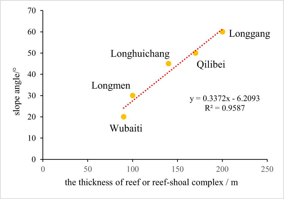
Investigation on the correlation between the thickness of reef or reef-shoal complex and slope angle of Changxing Formation of the study area.
5.1.2 Sea-level change
Previous studies have confirmed the close relationship between sea-level changes and the shape of the platform margin of the Changxing Formation in the Sichuan Basin, as well as reef development [48,50,53,65].
Optimal sea level rates are essential for promoting reef growth. Specifically, excessively rapid or slow rates of sea-level rise impose restrictions on reef growth [65]. The reefs in different platform margins in the study area exhibited varying degrees of migration towards slope-trough directions during falling sea levels. Similarly, paleogeomorphology-controlled platform margin belts displayed distinct morphological characteristics during lateral migration towards troughs. Notably, in the gentle-slope area, lateral migration is more pronounced (Figure 8a and c).
The internal superposition style and migration law of reefs in the Changxing Formation were influenced by fluctuating sea levels. Paleogeomorphic variations resulting from syn-sedimentary tectonic activities governed the morphology of the platform margin and reef development behavior, leading to diverse responses of reef formation to sea-level change based on distinct paleogeomorphic characteristics (Figure 11). In gently sloping platform-margin belts with minimal differences in paleogeomorphology and gentle terrain, reefs exhibited a more pronounced response to sea-level changes, characterized by continuous lateral reef migration. Conversely, well-developed reefs in steeply sloping platform-margin belts displayed multi-stage vertical reef aggradation due to interactions between sedimentary faults and sea level fluctuations, along with limited transverse reef migration and notable facies changes in the transverse direction.

(a) Types of Changxing platform margin belts and reef development model on both sides of the Kaijiang-Liangping trough in the Sichuan Basin. (b) SSF reef development model; (c) SSP reef development model; (d) SMP reef development model; and (e) GMP reef development model.
5.2 Development model of reefs in different types of platform margin belts
Four development models of reefs are established based on the statistics of the types, characteristics, and reef development characteristics of the Changxing platform margins on both sides of the Kaijiang-Liangping trough in the Sichuan Basin. These models consider factors such as slope angle, migration patterns, and spatial distribution characteristics of the reefs (Figure 11). The subsequent subsections will discuss these models.
The reef development model of the SSF is illustrated in Figure 11b. This particular pattern of reef development model primarily occurs in the Longgang area on the western side of the trough. Only one platform margin develops in this region, exhibiting a relatively narrow lateral distribution. The platform margin reef found in the Changxing Formation features a substantial sediment thickness. Generally, multi-level reefs are vertically superimposed without any significant horizontal migration pattern (Figure 12a).

Types and evolutionary models of the platform margin belts of the Changxing Formation platform on both sides of the Kaijiang-Liangping trough in the Sichuan Basin are as follows: (a) SSF evolutionary model, corresponding to Figure 11b; (b) SSP evolutionary model, corresponding to Figure 11c; (c) SMP evolutionary model, corresponding to Figure 11d; and (d) GMP evolutionary model, corresponding to Figure 11d.
The reef development model of the SSP is manifested in Figure 11c. This kind of reef development model is mainly found in the Longmen area on the west side of the trough. In this region, only one narrow horizontally distributed platform margin is formed. The early-developed reefs in the Changhsingian age are situated considerably from the trough, while the late-developed reefs are relatively closer to the trough, clearly indicating horizontal migration features (Figure 12b).
The reef development model of the SMP is revealed in Figure 11d. This kind of reef was mainly developed in the Qilibei area on the eastern side of the trough. Compared with the two former types, this type of platform margin was most notably developed in two rows on the platform margin, and the overall distribution range of the platform margin is relatively wide. The reefs developed in the whole Changhsingian age, but the overall development mode of the reefs was dominated by aggradation, which reflects the characteristics of weak lateral migration (Figure 12c).
The reef development model of the gentle-slope, multiple-platform margin belts controlled by paleogeomorphology is demonstrated in Figure 11e. This type of reef developed in the Wubaiti area on the eastern side of the trough. Multiple rows of platform margins have been developed in this area, and even three rows of platform margin belts have been developed in some areas. The platform margin area has the broadest horizontal distribution. Reefs were developed in the whole Changhsingian age, and both show observable lateral migration, while the vertical aggradation characteristics of the multi-stage reefs are relatively weak (Figure 12d).
6 Conclusion
Seismic and drilling analyses confirm that many reef deposits developed along the platform margins on both sides of the Kaijiang-Liangping trough in the Changhsingian age. Four types of platform margin belts developed on both sides of the Kaijiang-Liangping trough based on a detailed description of the typical 3D seismic profiles and drilling analysis: (1) steep-slope, single-platform margin belts controlled by faults; (2) steep-slope, single-platform margin belts controlled by paleogeomorphology; (3) steep-slope, multiple-platform margin belts controlled by paleogeomorphology; and (4) gentle-slope, multiple-platform margin belts controlled by paleogeomorphology. The reefs developed in different platform margin belts show different growth patterns, evolution histories, and lateral migration paths.
The steep-slope, single-platform margin belts controlled by faults have the largest reef deposit thickness. Although the gentle-slope, multiple-platform margin belts controlled by paleogeomorphology produce the most miniature reefs according to the four types of reef development models, the reservoir potential for this platform margin is still optimistic because of its massive transverse distribution area and extremely high degree of dolomitization.
This study proposes that syn-sedimentary fault activities in the extensional background controlled the carbonate growth patterns formed in the Changxing Formation and the associated morphological characteristics of the platform margin belt. Changing sea level controlled the internal superposition patterns and migration path for the reef facies in the Changxing Formation.
Acknowledgments
We would like to thank reviewers and the editor for their careful reviews and useful comments.
-
Funding information: This work was supported by the National Natural Science Foundation of China (Grant No. 42002180), Institute Funds under CNPC (Grant No. 2020D-5008-05 and 2023-N/G-61577).
-
Conflict of interest: Authors state no conflict of interest.
References
[1] Alam H, Paterson DW, Syarifuddin N, Busono I, Corbin SG. Reservoir potential of carbonate rocks in the Kutai Basin region, East Kalimantan, Indonesia. 1999;17(1–2):203–14. 10.1016/s0743-9547(98)00047-6.Search in Google Scholar
[2] Aghda SMF, Taslimi M, Fahimifar A. Adjusting porosity and permeability estimation by nuclear magnetic resonance: a case study from a carbonate reservoir of south of Iran. J Pet Explor Prod Technol. 2018;8:1113–27. 10.1007/s13202-018-0474-z.Search in Google Scholar
[3] Kelly EH, Robert GL, Charles K. Stratal architecture of a halokinetically controlled patch reef complex and implications for reservoir quality: A case study from the Aptian James Limestone in the Fairway Field, East Texas Basin. Sediment Geol. 2019;387:87–103. 10.1016/j.sedgeo.2019.04.009.Search in Google Scholar
[4] Stephen NE, Hyunhee B. Deposition, diagenesis and reservoir quality of an Oligocene reefal-margin limestone succession: Asmari Formation, United Arab Emirates. Sediment Geol. 2019;1:393–4. 10.1016/j.sedgeo.2019.105535.Search in Google Scholar
[5] Yasir B, Muhammad AF, Ajay B, Amir AB, Syed HA, Qazi SI, et al. Seismic expression of miocene carbonate platform and reservoir characterization through geophysical approach: application in central Luconia, offshore Malaysia. J Pet Explor Prod. 2021;11:1533–44. 10.1007/s13202-021-01132-2.Search in Google Scholar
[6] Jin ZJ. Formation and accumulation of oil and gas in marine carbonate sequences in Chinese sedimentary basins. Sci China Earth Sci. 2012;55:368–85. 10.1007/s11430-011-4264-4.Search in Google Scholar
[7] Zhao WZ, Shen AJ, Zhou JG, Wang XF, Lu JM. Types, characteristics, origin and exploration significance of reef-shoal reservoirs: A case study of Tarim Basin, NW China and Sichuan Basin, SW China. Pet Explor Dev. 2014;41(3):283–93. 10.1016/S1876-3804(14)60034-3.Search in Google Scholar
[8] Wang DP, Bai GP, Xu Y, Chen XL, Tao CZ, Zhang ML. Characteristics and hydrocarbon distribution of Paleozoic giant marine carbonate rock oil-gas field in the world. J Palaeogeogr. 2016;18(1):80–92. 10.7605/gdlxb.2016.01.006.Search in Google Scholar
[9] Zhao WZ, Wang ZC, Hu SY, Pan WQ, Yang Y, Bao HP, et al. Large-scale hydrocarbon accumulation factors and characteristics of marine carbonate reservoirs in three large onshore cartonic basins in China. Acta Petrolei Sin. 2012;33:1–10. 10.7623/syxb2012S2001.Search in Google Scholar
[10] Ma YS, He DF, Cai XY, Liu B. Distribution and fundamental science questions for petroleum geology of marine carbonate in China. Acta Petrol Sin. 2017;33(4):1007–20. CNKI: SUN: YSXB.0.2017-04-001.Search in Google Scholar
[11] Xie ZY, Wei GQ, Li J, Yang W, Zhang GW, Guo JY, et al. Reservoir characteristics and accumulation models of large carbonate gas fields in China. Acta Petrol Sin. 2013;34:29–40. 10.7623/syxb2013S1003.Search in Google Scholar
[12] Chen AQ, Hou MC, Chen HD, Xu SL, Zhong YJ, Liu WJ. Marine carbonate exploration history and the basic driving action from sedimentology in China. Acta Sedimentol Sin. 2017;35(5):1054–62. 10.14027/j.cnki.cjxb.2017.05.016.Search in Google Scholar
[13] Wang YG, Wen YC, Zhang F, Yang Y, Zhang J. Distribution law of the organic reefs in Changxing Formation of upper Permian in East Sichuan. Nat Gas Ind. 1998;18(06):25–30 + 7–8. 10.3321/j.issn:1000-0976.1998.06.001.Search in Google Scholar
[14] Wei GQ, Yang W, Liu MC, Wu SJ, Mo WL, Jin H, et al. Characteristics and distribution of platform-margin reef- shoal reservoirs in Changxing- Feixianguan Formations to the west of ocean trough, E’xi- Chengkou area. Oil Gas Geol. 2021;42(3):661–72 + 764. 10.11743/ogg20210312.Search in Google Scholar
[15] Guo TL. Sequence strata of the platform edge in the Changxing and Feixianguan formationsin the Yuanba area‚northeastern Sichuan Basin and their control on reservoirs. Acta Petrolei Sin. 2011;32(3):387–94. 10.7623/syxb201103003.Search in Google Scholar
[16] Hu MY, Hu ZG, Qiu XS, Zhao EZ, Wang D. Platform edge reef and bank structure and depositional model of Changxing formation in Panlongdong section, Xuanhan, northeastern Sichuan. J Earth Sci. 2012;23:431–41. 10.1007/s12583-012-0266-1.Search in Google Scholar
[17] Li QF, Wang ZC, Li J, Jiang QC, Wang TS, Yin JF, et al. Discovery of Yanting-Tongnan trough of late Permian in Sichuan basin and its significance. J Earth Sci. 2012;23:582–96. 10.1007/s12583-012-0276-z.Search in Google Scholar
[18] Wu J. Control of intracratonic sags on the hydrocarbon accumulations in the marine strata across the Sichuan Basin, China. J Chengdu Univ Technol (Sci & Technol Ed). 2016;43(1):1–23. 10.3969/j.issn.1671-9727.2016.01.01.Search in Google Scholar
[19] Guo C, Li GR, Wei HR, Xia FY, Xie FC. Stratigraphic architecture and platform evolution of the Changxing Formation (Upper Permian) in the Yuanba Gas Field, northeastern Sichuan Basin, China. Arab J Geosci. 2016;9:359. 10.1007/s12517-016-2348-3.Search in Google Scholar
[20] Mo WL, Su N, Wei GQ, Liu MC, Xing FC. Structural control, seismic expression, and types of reefs of rifting margins in the late Permian Changxing Age, Sichuan Basin, China. Arab J Geosci. 2019;12:788. 10.1007/s12517-019-4720-6.Search in Google Scholar
[21] Wang XZ, Li B, Yang XY, Wen L, Xu L, Xie SY, et al. Characteristics of “Guangyuan-Wangcang” trough during Late Middle Permian and its petroleum geological significance in northern Sichuan Basin, SW China. Pet Explor Dev. 2021;48(3):655–69. 10.1016/S1876-3804(21)60052-6.Search in Google Scholar
[22] Zhang B, Zheng RC, Wang XB, Zheng C, Wen HG, Luo Y, et al. Geochemical characteristics and diagenetic systems of dolomite reservoirs of the Changxing Formation in the eastern Sichuan Basin, China. Pet Sci. 2012;9:141–53. 10.1007/s12182-012-0194-9.Search in Google Scholar
[23] Zhao R, Wu YS, Jiang HX, Liu QS. Oxygen isotope clue to migration of dolomitizing fluid as exampled by the Changxing Formation dolomite at Panlongdong, northeastern Sichuan. J Earth Sci. 2017;28:333–46. 10.1007/s12583-017-0724-x.Search in Google Scholar
[24] Liang X, Tong MS, Liang F, Deng B, Liu W, Li F, et al. Characteristics of the east section of the Late Permian Tangting-Pengxi intracratonic sag and its controlling effects on the hydrocarbon accumulation of the Changxing Formation in the middle Sichuan Basin. Nat Gas Geosci. 2019;30(2):176–89. 10.11764/j.issn.1672-1926.2018.12.005.Search in Google Scholar
[25] Li PP, Zou HY, Yu XY, Hao F, Wang GW. Source of dolomitizing fluids and dolomitization model of the upper Permian Changxing and Lower Triassic Feixianguan formations, NE Sichuan Basin, China. Mar Pet Geol. 2021;125:104834. 10.1016/j.marpetgeo.2020.104834.Search in Google Scholar
[26] Ma YS, Guo TL, Zhao XF, Cai XY. The formation mechanism of high-quality dolomite reservoir in the deep of Puguang Gas Field. Sci China Ser D: Earth Sci. 2008;51:53–64. 10.1007/s11430-008-5008-y.Search in Google Scholar
[27] Zhou JG, Deng HY, Yu Z, Guo Q, Zhang R, Zhang JY, et al. The genesis and prediction of dolomite reservoir in reef-shoal of changxing formation-feixianguan formation in sichuan basin. J Pet Sci Eng. 2019;178:324–35. 10.1016/j.petrol.2019.03.020.Search in Google Scholar
[28] Huo F, Wang XZ, Wen HG, Xu WL, Huang HW, Jiang HC, et al. Genetic mechanism and pore evolution in high quality dolomite reservoirs of the Changxing-Feixianguan Formation in the northeastern Sichuan Basin, China. J Pet Sci Eng. 2020;194:107511. 10.1016/j.petrol.2020.107511.Search in Google Scholar
[29] Gu YF, Liao YS, Xu CH, Jiang YQ, Zhong KX, Fu YH, et al. Genesis of Upper Permian Changxing Formation dolomites, south of Kaijiang-Liangping Trough, SW China: evidence from petrology, geochemistry, and fluid inclusions. Arab J Geosci. 2021;14:681. 10.1007/s12517-021-07007-4.Search in Google Scholar
[30] Ma YS, Cai XY, Guo TL. The controlling factors of oil and gas charging and accumulation of Puguang gas field in the Sichuan Basin. Chin Sci Bull. 2007;52:193–200. 10.1007/s11434-007-6007-7.Search in Google Scholar
[31] Gu YF, Jiang YQ, Fu YH, Chen ZY, Zhang JW, Zhou L, et al. Hydrocarbon accumulation and main controlling factors of reef-shoal gas reservoirs in Changxing Formation in the complex tectonic area, Eastern Sichuan Basin. Arab J Geosci. 2019;12:776. 10.1007/s12517-019-4922-y.Search in Google Scholar
[32] Adjenovi D, Kilibarda Z, Radulovi N. Late Triassic to Late Jurassic evolution of the Adriatic carbonate platform and Budva Basin, southern Montenegro. Sediment Geol. 2008;204:1–17. 10.1016/j.sedgeo.2007.12.005.Search in Google Scholar
[33] Frost EL, Kerans C. Platform margin trajectory as a control on syndepositional fracture patterns, Canning Basin, western Australia. J Sediment Res. 2009;79(2):44–55. 10.2110/jsr.2009.014.Search in Google Scholar
[34] Rankey EC, Garza-Pérez JR. Seascape metrics of shelf-margin reefs and reef sand aprons of Holocene carbonate platforms. J Sediment Res. 2012;82(1):53–71. 10.2110/jsr.2012.7.Search in Google Scholar
[35] Rankey EC, Guidry SA, Reeder SL, Guarin H. Geomorphic and sedimentologic heterogeneity along a Holocene shelf margin: Caicos platform. J Sediment Res. 2009;79(6):440–56. 10.2110/jsr.2009.042.Search in Google Scholar
[36] Xing FC, Lu YC, Guo TL, Li ST, Hou MC, Hu HR, et al. Sedimentary texture diversity of different carbonate platform margins and it its significance for petroleum exploration: A case study of carbonate platform margins in Feixianguan period of the Early Triassic, NE Sichuan basin, China. Acta Petrol Sin. 2017;33(4):1305–16.Search in Google Scholar
[37] Xie WR, Yang W, Wang ZC, Wei GQ, Ma SY, Hao T, et al. Characteristics and main controlling factors on the development of a platform margin belt and its effect on hydrocarbon accumulation: A case study of Dengying Formation in Sichuan Basin. Chin J Geol. 2021;56(3):867–83. 10.12017/dzkx.2021.045.Search in Google Scholar
[38] Harris PM. The Joulters ooid shoal, great Bahama bank. In: Peryt TM, editor. Coated Grains. Berlin, Heidelberg: Springer; 1983. p. 132–41. 10.1007/978-3-642-68869-0_11.Search in Google Scholar
[39] Ruppel SC, Ward WB. Outcrop-based characterization of the Leonardian carbonate platform in West Texas: Implications for sequence-stratigraphic styles in the Lower Permian. AAPG Bull. 2013;97(2):223–50. 10.1306/05311212013.Search in Google Scholar
[40] Phelps RM, Kerans C, Loucks RG, Da Gama ROBP, Jeremiah J, Hull D. Oceanographic and eustatic control of carbonate platform evolution and sequence stratigraphy on the Cretaceous(Valanginian-Campanian)passive margin, northern Gulf of Mexico. Sedimentology. 2014;61(2):461–96. 10.1111/sed.12062.Search in Google Scholar
[41] Playton TE, Kerans C. Late Devonian carbonate margins and foreslopes of the lennard shelf, Canning basin, Western Australia,Part A: Development during backstepping and the aggradation-toprogradation transition. J Sediment Res. 2015;85(11):1334–61. 10.2110/jsr.2015.84.Search in Google Scholar
[42] Lukasik J, Simo JA. Controls on carbonate platform and reef development. SEPM Spec Publ. 2008;89:7–8. 10.2110/pec.08.89.Search in Google Scholar
[43] Morrow JR, Sandberg CA. Evolution of Devonian carbonateshelf margin, Nevada. Geosphere. 2008;4(2):445–58. 10.1130/GES00134.1.Search in Google Scholar
[44] Williams HD, Burgess PM, Wright VP, Porta GD, Granjeon D. Investigating carbonate platform types: Multiple controls and a continuum of geometries. J Sediment Res. 2011;81(1):18–37. 10.2110/jsr.2011.6.Search in Google Scholar
[45] Xu AN, Wang ZC, Jiang XF, Zhai XF, Yin JF. Morphological characteristics of platform margins along the Kaijiang-Liangping Trough and their influences on reservoir development in the Sichuan Basin. Nat Gas Ind. 2014;34(4):37–43. 10.3787/j.issn.1000-0976.2014.04.005.Search in Google Scholar
[46] Yan ZL, Xing FC, Duan JB, Hu HR, Wu SY. Sedimentary texture and reservoir distribution of platform margin reef-flat zone in changxing formation of Northeastern Sichuan Basin. Xinjiang Pet Geol. 2018;39(3):311–7. 10.7657/XJPG20180308.Search in Google Scholar
[47] Hu ZG, Don QM, Li SL, Su N, Zuo MT, Qin P. Combination regularities of reef-beach and main controlling factors in Changxing-Feixianguan Formation of eastern Sichuan-northern Chongqing area. J China Univ Pet (Ed Nat Sci). 2019;43(3):25–35. 10.3969/j.issn.1673-5005.2019.03.003.Search in Google Scholar
[48] Peng C, Zheng RC, Chen H, Wang LY, Luo J, Liang H. Reef control factors and new seismic prediction techniques of Changxing Formation, east of Kaijiang- Liangping trough, Sichuan Basin. Pet Geol & Exp. 2019;41(4):641–20. 10.11781/sysydz201904614.Search in Google Scholar
[49] Wu SJ, Wei GQ, Yang W, Duan SF, Jin H, Xie WR, et al. Development characteristics of reefs on the platform margin of Changxing Formation in eastern Kaijiang-Liangping ocean trough and its significance for petroleum geological exploration. China Pet Explor. 2019;24(4):457–65. 10.3969/j.issn.1672-7703.2019.04.006.Search in Google Scholar
[50] Ma DQ, Tian JC, Lin XB, Wen L, Xu L. Differences and controlling factors of Changxing Formation reefs of the Permian in the Sichuan Basin. Oil & Gas Geol. 2020;41(6):1176–87. 10.11743/ogg20200606.Search in Google Scholar
[51] Liu SG, Sun W, Song JM, Deng B, Zhong Y, Luo C, et al. Tectonics-controlled distribution of marine petroleum accumulations in the Sichuan Basin, China. Earth Sci Front (China Univ Geosciences(Beijing); Peking Univ. 2015;22(3):146–60. 10.13745/j.esf.2015.03.013.Search in Google Scholar
[52] Zou CN, Xu CC, Wang ZC, Hu SY, Yang G, Li J, et al. Geological characteristics and forming conditions of the platform margin large reef-shoal gas province in the Sichuan Basin. Pet Explor Dev. 2011;38(6):641–51. 10.1016/S1876-3804(12)60001-9.Search in Google Scholar
[53] Wen L, Zhang Q, Yang Y, Liu HY, Che Q, Liu W, et al. Factors controlling reef-bank reservoirs in the Changxing-Feixianguan Formation in the Sichuan Basin and their play fairways. Nat Gas Ind. 2012;32(1):39–44. 10.3787/j.issn.1000-0976.2012.01.007.Search in Google Scholar
[54] Vail PR, Mitchum RM, Thompson S, Ш. Seismic stratigraphy and global changes of sea level, part 4: Global cycles of relative changes of sea level//PAYTON C E. Seismic stratigraphy: Applications to hydrocarbon exploration. Tulsa: American Association of Petroleum Geologists; 1997. p. 83–98.Search in Google Scholar
[55] Deng ZQ, Hu MY, Zuo MT, Zhang S, Song H. High-frequency sequence and its control on reef beach bodies of Changxing Formation in Eastern Longgang area. Sichuan BasPet Geol Oilfield Dev Daqing. 2023;42(01):11–22. 10.19597/j.issn.1000-3754.202110019.Search in Google Scholar
[56] Wang D, Liu H, Tang S, Bai JH, Zhou G, Li ZY, et al. Sedimentary architecture and distribution of intra-platform shoal in sequence framework of Permian Changxing Formation in central Sichuan Basin, SW China. Pet Explor Dev Online. 2023;50(2):388–403. 10.1016/S1876-3804(23)60395-7.Search in Google Scholar
[57] Ma YS, Mo CL, Tan QY, Yu Q. A discussion on Kaijiang-Liangping ocean trough. Oil Gas Geol. 2006;27(3):326–31. 10.11743/ogg20060306.Search in Google Scholar
[58] Jiang ZB, Wang XZ, Zhang F, Zeng DM, Zhang JY, Lu TM. Distribution and controlling factors of reefs and oolitic beaches for the Changxing to Feixianguan formations in the northern Sichuan basin. Geol China. 2008;35(5):940–50. 10.3969/j.issn.1000-3657.2008.05.014.Search in Google Scholar
[59] Luo ZL. A discussion of new prospects for gas field exploration related to the Taphrogenic Movement in Sichuan Basin. J Chengdu Univ Technol(Science & Technology Ed). 1983;2:1–13. CNKI: SUN: CDLG.0.1983-02-000.Search in Google Scholar
[60] Luo ZL, Jin YZ, Zhu KY, Zhao XK. On Emei taphrogensis of the upper Yangtze platform. Geol Rev. 1988;1:11–24. 10.3321/j.issn:0371-5736.1988.01.002.Search in Google Scholar
[61] Feng CJ, Zhang JQ, Cuan JM. The upper Permian sedimentary facies in Sichuan Basin and their tectonic controls. Sediment Geol Tethyan Geol. 1988;34(2):1–15. CNKI: SUN: TTSD.0.1988-02-000.Search in Google Scholar
[62] Snyder WS, Spinosa C, Davydov VI, Belasky P. Petroleum geology of the southern pre-Uralian foredeep with reference to the northeastern Pre-Caspian Basin. Int Geol Rev. 1994;36:452–72. 10.1080/00206819409465471.Search in Google Scholar
[63] Annette DG, Nancy C, Kate MT. Syndepositional fault control on lower Frasnian platform evolution, Lennard Shelf, Canning Basin, Australia. Geology. 2009;37(4):331–4. 10.1130/G25461A.1.Search in Google Scholar
[64] Tan XC, Luo B, Jiang XF, Liu H, Li L, Zhang BJ, et al. Controlling effect of basement fault on Changxing formation reef in Sichuan Basin. Geol Rev. 2012;58(2):277–84. 10.3969/j.issn.0371-5736.2012.02.009.Search in Google Scholar
[65] Wang XZ, Zhang F, Ma Q, Yang MP, Wang YG, Wen YC, et al. The characteristics of reef and bank and the fluctuation of sea-level in Feixianguan period of late Permian-Early Triassic, East Sichuan Basin. Acta Sedimentol Sin. 2002;2:249–54. 10.3969/j.issn.1000-0550.2002.02.011.Search in Google Scholar
© 2024 the author(s), published by De Gruyter
This work is licensed under the Creative Commons Attribution 4.0 International License.
Articles in the same Issue
- Regular Articles
- Theoretical magnetotelluric response of stratiform earth consisting of alternative homogeneous and transitional layers
- The research of common drought indexes for the application to the drought monitoring in the region of Jin Sha river
- Evolutionary game analysis of government, businesses, and consumers in high-standard farmland low-carbon construction
- On the use of low-frequency passive seismic as a direct hydrocarbon indicator: A case study at Banyubang oil field, Indonesia
- Water transportation planning in connection with extreme weather conditions; case study – Port of Novi Sad, Serbia
- Zircon U–Pb ages of the Paleozoic volcaniclastic strata in the Junggar Basin, NW China
- Monitoring of mangrove forests vegetation based on optical versus microwave data: A case study western coast of Saudi Arabia
- Microfacies analysis of marine shale: A case study of the shales of the Wufeng–Longmaxi formation in the western Chongqing, Sichuan Basin, China
- Multisource remote sensing image fusion processing in plateau seismic region feature information extraction and application analysis – An example of the Menyuan Ms6.9 earthquake on January 8, 2022
- Identification of magnetic mineralogy and paleo-flow direction of the Miocene-quaternary volcanic products in the north of Lake Van, Eastern Turkey
- Impact of fully rotating steel casing bored pile on adjacent tunnels
- Adolescents’ consumption intentions toward leisure tourism in high-risk leisure environments in riverine areas
- Petrogenesis of Jurassic granitic rocks in South China Block: Implications for events related to subduction of Paleo-Pacific plate
- Differences in urban daytime and night block vitality based on mobile phone signaling data: A case study of Kunming’s urban district
- Random forest and artificial neural network-based tsunami forests classification using data fusion of Sentinel-2 and Airbus Vision-1 satellites: A case study of Garhi Chandan, Pakistan
- Integrated geophysical approach for detection and size-geometry characterization of a multiscale karst system in carbonate units, semiarid Brazil
- Spatial and temporal changes in ecosystem services value and analysis of driving factors in the Yangtze River Delta Region
- Deep fault sliding rates for Ka-Ping block of Xinjiang based on repeating earthquakes
- Improved deep learning segmentation of outdoor point clouds with different sampling strategies and using intensities
- Platform margin belt structure and sedimentation characteristics of Changxing Formation reefs on both sides of the Kaijiang-Liangping trough, eastern Sichuan Basin, China
- Enhancing attapulgite and cement-modified loess for effective landfill lining: A study on seepage prevention and Cu/Pb ion adsorption
- Flood risk assessment, a case study in an arid environment of Southeast Morocco
- Lower limits of physical properties and classification evaluation criteria of the tight reservoir in the Ahe Formation in the Dibei Area of the Kuqa depression
- Evaluation of Viaducts’ contribution to road network accessibility in the Yunnan–Guizhou area based on the node deletion method
- Permian tectonic switch of the southern Central Asian Orogenic Belt: Constraints from magmatism in the southern Alxa region, NW China
- Element geochemical differences in lower Cambrian black shales with hydrothermal sedimentation in the Yangtze block, South China
- Three-dimensional finite-memory quasi-Newton inversion of the magnetotelluric based on unstructured grids
- Obliquity-paced summer monsoon from the Shilou red clay section on the eastern Chinese Loess Plateau
- Classification and logging identification of reservoir space near the upper Ordovician pinch-out line in Tahe Oilfield
- Ultra-deep channel sand body target recognition method based on improved deep learning under UAV cluster
- New formula to determine flyrock distance on sedimentary rocks with low strength
- Assessing the ecological security of tourism in Northeast China
- Effective reservoir identification and sweet spot prediction in Chang 8 Member tight oil reservoirs in Huanjiang area, Ordos Basin
- Detecting heterogeneity of spatial accessibility to sports facilities for adolescents at fine scale: A case study in Changsha, China
- Effects of freeze–thaw cycles on soil nutrients by soft rock and sand remodeling
- Vibration prediction with a method based on the absorption property of blast-induced seismic waves: A case study
- A new look at the geodynamic development of the Ediacaran–early Cambrian forearc basalts of the Tannuola-Khamsara Island Arc (Central Asia, Russia): Conclusions from geological, geochemical, and Nd-isotope data
- Spatio-temporal analysis of the driving factors of urban land use expansion in China: A study of the Yangtze River Delta region
- Selection of Euler deconvolution solutions using the enhanced horizontal gradient and stable vertical differentiation
- Phase change of the Ordovician hydrocarbon in the Tarim Basin: A case study from the Halahatang–Shunbei area
- Using interpretative structure model and analytical network process for optimum site selection of airport locations in Delta Egypt
- Geochemistry of magnetite from Fe-skarn deposits along the central Loei Fold Belt, Thailand
- Functional typology of settlements in the Srem region, Serbia
- Hunger Games Search for the elucidation of gravity anomalies with application to geothermal energy investigations and volcanic activity studies
- Addressing incomplete tile phenomena in image tiling: Introducing the grid six-intersection model
- Evaluation and control model for resilience of water resource building system based on fuzzy comprehensive evaluation method and its application
- MIF and AHP methods for delineation of groundwater potential zones using remote sensing and GIS techniques in Tirunelveli, Tenkasi District, India
- New database for the estimation of dynamic coefficient of friction of snow
- Measuring urban growth dynamics: A study in Hue city, Vietnam
- Comparative models of support-vector machine, multilayer perceptron, and decision tree predication approaches for landslide susceptibility analysis
- Experimental study on the influence of clay content on the shear strength of silty soil and mechanism analysis
- Geosite assessment as a contribution to the sustainable development of Babušnica, Serbia
- Using fuzzy analytical hierarchy process for road transportation services management based on remote sensing and GIS technology
- Accumulation mechanism of multi-type unconventional oil and gas reservoirs in Northern China: Taking Hari Sag of the Yin’e Basin as an example
- TOC prediction of source rocks based on the convolutional neural network and logging curves – A case study of Pinghu Formation in Xihu Sag
- A method for fast detection of wind farms from remote sensing images using deep learning and geospatial analysis
- Spatial distribution and driving factors of karst rocky desertification in Southwest China based on GIS and geodetector
- Physicochemical and mineralogical composition studies of clays from Share and Tshonga areas, Northern Bida Basin, Nigeria: Implications for Geophagia
- Geochemical sedimentary records of eutrophication and environmental change in Chaohu Lake, East China
- Research progress of freeze–thaw rock using bibliometric analysis
- Mixed irrigation affects the composition and diversity of the soil bacterial community
- Examining the swelling potential of cohesive soils with high plasticity according to their index properties using GIS
- Geological genesis and identification of high-porosity and low-permeability sandstones in the Cretaceous Bashkirchik Formation, northern Tarim Basin
- Usability of PPGIS tools exemplified by geodiscussion – a tool for public participation in shaping public space
- Efficient development technology of Upper Paleozoic Lower Shihezi tight sandstone gas reservoir in northeastern Ordos Basin
- Assessment of soil resources of agricultural landscapes in Turkestan region of the Republic of Kazakhstan based on agrochemical indexes
- Evaluating the impact of DEM interpolation algorithms on relief index for soil resource management
- Petrogenetic relationship between plutonic and subvolcanic rocks in the Jurassic Shuikoushan complex, South China
- A novel workflow for shale lithology identification – A case study in the Gulong Depression, Songliao Basin, China
- Characteristics and main controlling factors of dolomite reservoirs in Fei-3 Member of Feixianguan Formation of Lower Triassic, Puguang area
- Impact of high-speed railway network on county-level accessibility and economic linkage in Jiangxi Province, China: A spatio-temporal data analysis
- Estimation model of wild fractional vegetation cover based on RGB vegetation index and its application
- Lithofacies, petrography, and geochemistry of the Lamphun oceanic plate stratigraphy: As a record of the subduction history of Paleo-Tethys in Chiang Mai-Chiang Rai Suture Zone of Thailand
- Structural features and tectonic activity of the Weihe Fault, central China
- Application of the wavelet transform and Hilbert–Huang transform in stratigraphic sequence division of Jurassic Shaximiao Formation in Southwest Sichuan Basin
- Structural detachment influences the shale gas preservation in the Wufeng-Longmaxi Formation, Northern Guizhou Province
- Distribution law of Chang 7 Member tight oil in the western Ordos Basin based on geological, logging and numerical simulation techniques
- Evaluation of alteration in the geothermal province west of Cappadocia, Türkiye: Mineralogical, petrographical, geochemical, and remote sensing data
- Numerical modeling of site response at large strains with simplified nonlinear models: Application to Lotung seismic array
- Quantitative characterization of granite failure intensity under dynamic disturbance from energy standpoint
- Characteristics of debris flow dynamics and prediction of the hazardous area in Bangou Village, Yanqing District, Beijing, China
- Rockfall mapping and susceptibility evaluation based on UAV high-resolution imagery and support vector machine method
- Statistical comparison analysis of different real-time kinematic methods for the development of photogrammetric products: CORS-RTK, CORS-RTK + PPK, RTK-DRTK2, and RTK + DRTK2 + GCP
- Hydrogeological mapping of fracture networks using earth observation data to improve rainfall–runoff modeling in arid mountains, Saudi Arabia
- Petrography and geochemistry of pegmatite and leucogranite of Ntega-Marangara area, Burundi, in relation to rare metal mineralisation
- Prediction of formation fracture pressure based on reinforcement learning and XGBoost
- Hazard zonation for potential earthquake-induced landslide in the eastern East Kunlun fault zone
- Monitoring water infiltration in multiple layers of sandstone coal mining model with cracks using ERT
- Study of the patterns of ice lake variation and the factors influencing these changes in the western Nyingchi area
- Productive conservation at the landslide prone area under the threat of rapid land cover changes
- Sedimentary processes and patterns in deposits corresponding to freshwater lake-facies of hyperpycnal flow – An experimental study based on flume depositional simulations
- Study on time-dependent injectability evaluation of mudstone considering the self-healing effect
- Detection of objects with diverse geometric shapes in GPR images using deep-learning methods
- Behavior of trace metals in sedimentary cores from marine and lacustrine environments in Algeria
- Spatiotemporal variation pattern and spatial coupling relationship between NDVI and LST in Mu Us Sandy Land
- Formation mechanism and oil-bearing properties of gravity flow sand body of Chang 63 sub-member of Yanchang Formation in Huaqing area, Ordos Basin
- Diagenesis of marine-continental transitional shale from the Upper Permian Longtan Formation in southern Sichuan Basin, China
- Vertical high-velocity structures and seismic activity in western Shandong Rise, China: Case study inspired by double-difference seismic tomography
- Spatial coupling relationship between metamorphic core complex and gold deposits: Constraints from geophysical electromagnetics
- Disparities in the geospatial allocation of public facilities from the perspective of living circles
- Research on spatial correlation structure of war heritage based on field theory. A case study of Jinzhai County, China
- Formation mechanisms of Qiaoba-Zhongdu Danxia landforms in southwestern Sichuan Province, China
- Magnetic data interpretation: Implication for structure and hydrocarbon potentiality at Delta Wadi Diit, Southeastern Egypt
- Deeply buried clastic rock diagenesis evolution mechanism of Dongdaohaizi sag in the center of Junggar fault basin, Northwest China
- Application of LS-RAPID to simulate the motion of two contrasting landslides triggered by earthquakes
- The new insight of tectonic setting in Sunda–Banda transition zone using tomography seismic. Case study: 7.1 M deep earthquake 29 August 2023
- The critical role of c and φ in ensuring stability: A study on rockfill dams
- Evidence of late quaternary activity of the Weining-Shuicheng Fault in Guizhou, China
- Extreme hydroclimatic events and response of vegetation in the eastern QTP since 10 ka
- Spatial–temporal effect of sea–land gradient on landscape pattern and ecological risk in the coastal zone: A case study of Dalian City
- Study on the influence mechanism of land use on carbon storage under multiple scenarios: A case study of Wenzhou
- A new method for identifying reservoir fluid properties based on well logging data: A case study from PL block of Bohai Bay Basin, North China
- Comparison between thermal models across the Middle Magdalena Valley, Eastern Cordillera, and Eastern Llanos basins in Colombia
- Mineralogical and elemental analysis of Kazakh coals from three mines: Preliminary insights from mode of occurrence to environmental impacts
- Chlorite-induced porosity evolution in multi-source tight sandstone reservoirs: A case study of the Shaximiao Formation in western Sichuan Basin
- Predicting stability factors for rotational failures in earth slopes and embankments using artificial intelligence techniques
- Origin of Late Cretaceous A-type granitoids in South China: Response to the rollback and retreat of the Paleo-Pacific plate
- Modification of dolomitization on reservoir spaces in reef–shoal complex: A case study of Permian Changxing Formation, Sichuan Basin, SW China
- Geological characteristics of the Daduhe gold belt, western Sichuan, China: Implications for exploration
- Rock physics model for deep coal-bed methane reservoir based on equivalent medium theory: A case study of Carboniferous-Permian in Eastern Ordos Basin
- Enhancing the total-field magnetic anomaly using the normalized source strength
- Shear wave velocity profiling of Riyadh City, Saudi Arabia, utilizing the multi-channel analysis of surface waves method
- Effect of coal facies on pore structure heterogeneity of coal measures: Quantitative characterization and comparative study
- Inversion method of organic matter content of different types of soils in black soil area based on hyperspectral indices
- Detection of seepage zones in artificial levees: A case study at the Körös River, Hungary
- Tight sandstone fluid detection technology based on multi-wave seismic data
- Characteristics and control techniques of soft rock tunnel lining cracks in high geo-stress environments: Case study of Wushaoling tunnel group
- Influence of pore structure characteristics on the Permian Shan-1 reservoir in Longdong, Southwest Ordos Basin, China
- Study on sedimentary model of Shanxi Formation – Lower Shihezi Formation in Da 17 well area of Daniudi gas field, Ordos Basin
- Multi-scenario territorial spatial simulation and dynamic changes: A case study of Jilin Province in China from 1985 to 2030
- Review Articles
- Major ascidian species with negative impacts on bivalve aquaculture: Current knowledge and future research aims
- Prediction and assessment of meteorological drought in southwest China using long short-term memory model
- Communication
- Essential questions in earth and geosciences according to large language models
- Erratum
- Erratum to “Random forest and artificial neural network-based tsunami forests classification using data fusion of Sentinel-2 and Airbus Vision-1 satellites: A case study of Garhi Chandan, Pakistan”
- Special Issue: Natural Resources and Environmental Risks: Towards a Sustainable Future - Part I
- Spatial-temporal and trend analysis of traffic accidents in AP Vojvodina (North Serbia)
- Exploring environmental awareness, knowledge, and safety: A comparative study among students in Montenegro and North Macedonia
- Determinants influencing tourists’ willingness to visit Türkiye – Impact of earthquake hazards on Serbian visitors’ preferences
- Application of remote sensing in monitoring land degradation: A case study of Stanari municipality (Bosnia and Herzegovina)
- Optimizing agricultural land use: A GIS-based assessment of suitability in the Sana River Basin, Bosnia and Herzegovina
- Assessing risk-prone areas in the Kratovska Reka catchment (North Macedonia) by integrating advanced geospatial analytics and flash flood potential index
- Analysis of the intensity of erosive processes and state of vegetation cover in the zone of influence of the Kolubara Mining Basin
- GIS-based spatial modeling of landslide susceptibility using BWM-LSI: A case study – city of Smederevo (Serbia)
- Geospatial modeling of wildfire susceptibility on a national scale in Montenegro: A comparative evaluation of F-AHP and FR methodologies
- Geosite assessment as the first step for the development of canyoning activities in North Montenegro
- Urban geoheritage and degradation risk assessment of the Sokograd fortress (Sokobanja, Eastern Serbia)
- Multi-hazard modeling of erosion and landslide susceptibility at the national scale in the example of North Macedonia
- Understanding seismic hazard resilience in Montenegro: A qualitative analysis of community preparedness and response capabilities
- Forest soil CO2 emission in Quercus robur level II monitoring site
- Characterization of glomalin proteins in soil: A potential indicator of erosion intensity
- Power of Terroir: Case study of Grašac at the Fruška Gora wine region (North Serbia)
- Special Issue: Geospatial and Environmental Dynamics - Part I
- Qualitative insights into cultural heritage protection in Serbia: Addressing legal and institutional gaps for disaster risk resilience