Structural detachment influences the shale gas preservation in the Wufeng-Longmaxi Formation, Northern Guizhou Province
-
Sheng Shi
 ,
Yuliang Mou
,
Yuliang Mou

Abstract
In order to reveal the restriction in shale gas enrichment of the Wufeng-Longmaxi Formation in the northern Guizhou province, the influence model of detachment layer was established through field geological investigation, core observation, logging, sample analysis, and geological background data. The response relationship between the detachment layer and the shale gas enrichment model in different structural formats was analyzed. The results show that the thickness of the Wufeng-Longmaxi Formation’s detachment layer is influenced by the conditions near the fault zones and mineralogical characteristics. The lithofacies of the detachment layer shows mainly a combination of clay-rich shale facies. This indicates that lithofacies type is one of the main factors influencing the variation in slip layer thickness. The detachment layer exhibits distinct well logging response characteristics and is influenced by nitrogen enrichment. The development of detachment fractures allows atmospheric nitrogen to infiltrate shale gas. It leads to poor gas saturation in the shale gas. In addition, the overall tectonic deformation in the northern Guizhou province was found to gradually intensify from Northwest to Southeast, and there were two tectonic models: a slot-shift tape transition belt and a spacer type deformation belt. The influence of decollements on shale gas preservation was barely found in the northern Guizhou province. It is mainly controlled by buried depth of the target layer, conditions of the cover layer, structural type, and deformation intensity.
1 Introduction
In the past few decades, North America has conducted large-scale exploration and development of shale gas, improving the global energy landscape [1,2]. At present, scholars have conducted a lot of research on shale gas preservation conditions, and it is generally believed that complex geological structures influence the primary factors constraining global shale gas exploration and development [2,3,4,5]. In these geological structures, tectonic activity is the most crucial factor as it determines the heterogeneity of reservoir properties and the preservation and migration of shale gas [6,7]. Antrim Shale, Albany Shale, Lewis Shale, Monterey shale, Marcellus shale, Eagle Ford shale, Lower Silurian shale in the Sichuan Basin, the Cambrian and Ordovician shales in the Tarim Basin, the Upper Cretaceous Gurpi shale in Iran, and the Alum shales in Northern Europe are all considered to be associated with tectonic activity [8,9,10,11,12]. Particularly, the structural detachment formed by tectonic activity has a negative influence on the preservation and enrichment of shale gas. It has become the primary reason limiting significant breakthroughs in shale gas exploration and development [11,13,14].
Structural detachment refers to the both sides detachment along one or several bedding planes caused by deformation. It is independent or partially independent [15]. Structural detachment, as thin-skinned structures, the deformation of the foreland sedimentary cover layer sliding over the main detachment plane (basement), forming fold-thrust fault structures, while the basement is not involved in the deformation. There is a significant discordance between the deformation of the cover layer and the basement. The detachment layer has critical control on the structural style, geometry, evolutionary process, and distribution of fold-thrust belts. Thus, the theory, physical model, and simulation could improve the analysis of the formation mechanism of structural detachment [16,17,18,19,20,21]. Li et al. used the discrete element method to numerically simulate the salt tectonic deformation and evolution in the Kuqa Depression of the Tarim Basin. The simulation results were verified by real-world integrating seismic profiles. Lianbo and Benming, considering the geological features, tectonic stress fields, and physical simulations, investigated the formation mechanism of abnormally high pressures in the Kuqa foreland thrust belt and the impact on hydrocarbon accumulation [22]. They showed the formation of abnormally high pressures is the main reason related to the intense tectonic compression during the Early Pleistocene. The tectonic uplift, undercompaction, and hydrocarbon generation are secondary factors contributing to the formation of abnormally high pressures. The abnormally high pressure in the Kuqa foreland thrust belt is one of the necessary conditions for the formation of large oil and gas fields [23]. Harris et al. revealed the formation mechanism of structural detachment based on the centrifugal physical test apparatus and simulated the evolution process of structural detachment. Nabiei et al. combining 2D seismic profiles, well data, and fieldwork analyzed the deformation styles of structural detachment in Sefid-Zakhur anticline structural style, Fars, Iran. The formation mechanism of structural detachment has a critical influence on oil and gas [11]. Zhou et al. collected geological, drilling, well logging, and 3D seismic data, analyzed the lithological composition and logging response characteristics of the main detachment layer in the eastern Sichuan region, and established a characteristic identification template for the main detachment layer. It is recognized that the gliding fold-thrust belt creates trapping conditions for the formation of large structural gas reservoirs [24]. Zamani used slip-shear stress component criteria to invert the stress state of the Zagros fold-thrust belt. It explores the initial stress field of the structural detachment zone. The result provides valuable reference for the accurate simulation of the production process [25]. Previous research has shown that structural detachment exhibits different characteristics in various fold-thrust belts, leading to distinct hydrocarbon occurrences. Therefore, the impact of the detachment system on shale gas preservation needs further analysis in the shale gas industry [26–29].
In recent years, significant breakthroughs have been made in the discovery and commercial development of shale gas fields in basin areas such as Changning, Weiyuan, and Fuling, China. It has also been achieved in the exploration of normal-pressure type shale gas in peripheral areas of the Sichuan Basin, such as Wulong and Daozhen. These areas are important replacement regions for increasing reserves and production [30,31]. The northern Guizhou province, as a transitional area from the Sichuan Basin to the central Guizhou uplift, exhibits characteristics of multiple periods, directions, and complex tectonic activity. Due to the occurrence of tectonic movements in multiple periods with heterogeneity in rock competence, the northern Guizhou province shows features of multiple episodes and layers of structural detachment. Additionally, the critical geological parameters from commercial exploitation areas cannot be directly applied to predict favorable reservoir areas for shale gas in the northern Guizhou province. The influence of structural detachment on shale gas content and accumulation patterns in this area needs further analysis.
The significance of structural detachment on shale gas preservation is fully analyzed in the northern Guizhou province. This study involved field geological surveys, sample analysis, core observations, and well logging data to systematically illustrate the distribution characteristics of structural detachment and its impact on shale gas preservation. It aims to provide guidance and reference for shale gas exploration planning in the northern Guizhou province.
2 Geological setting
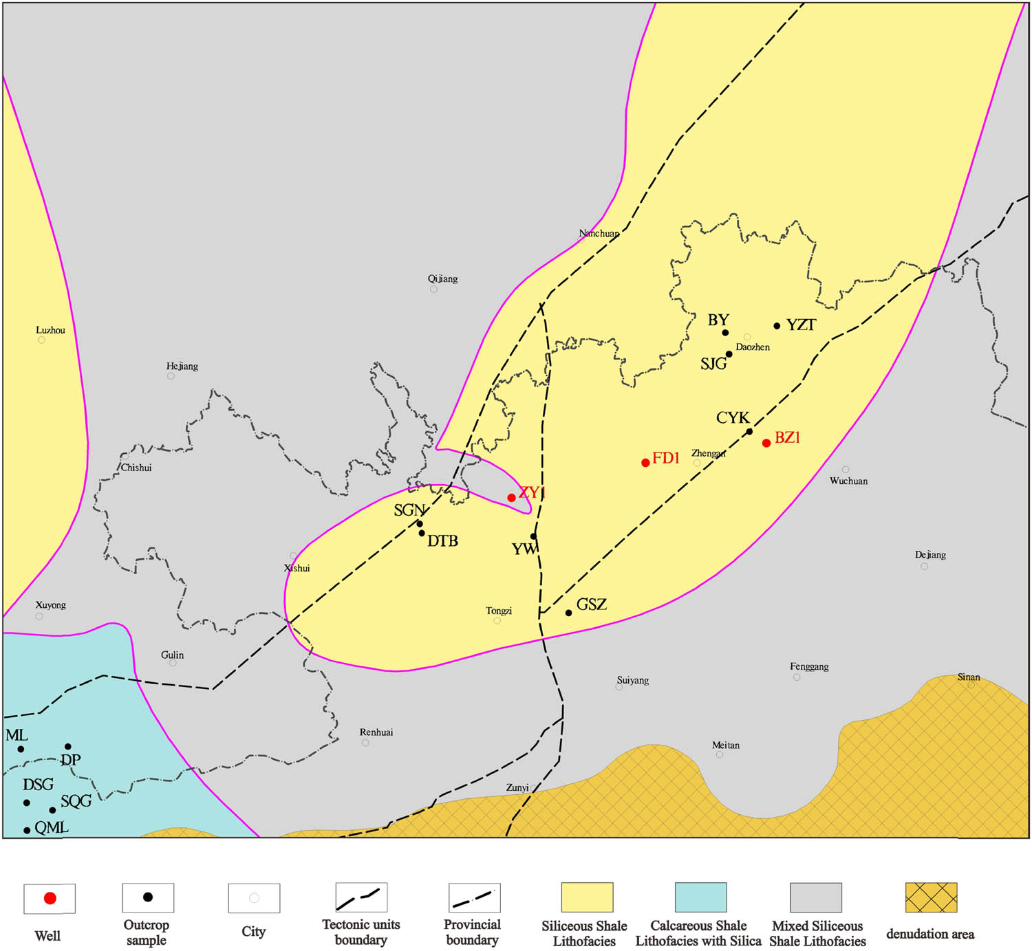
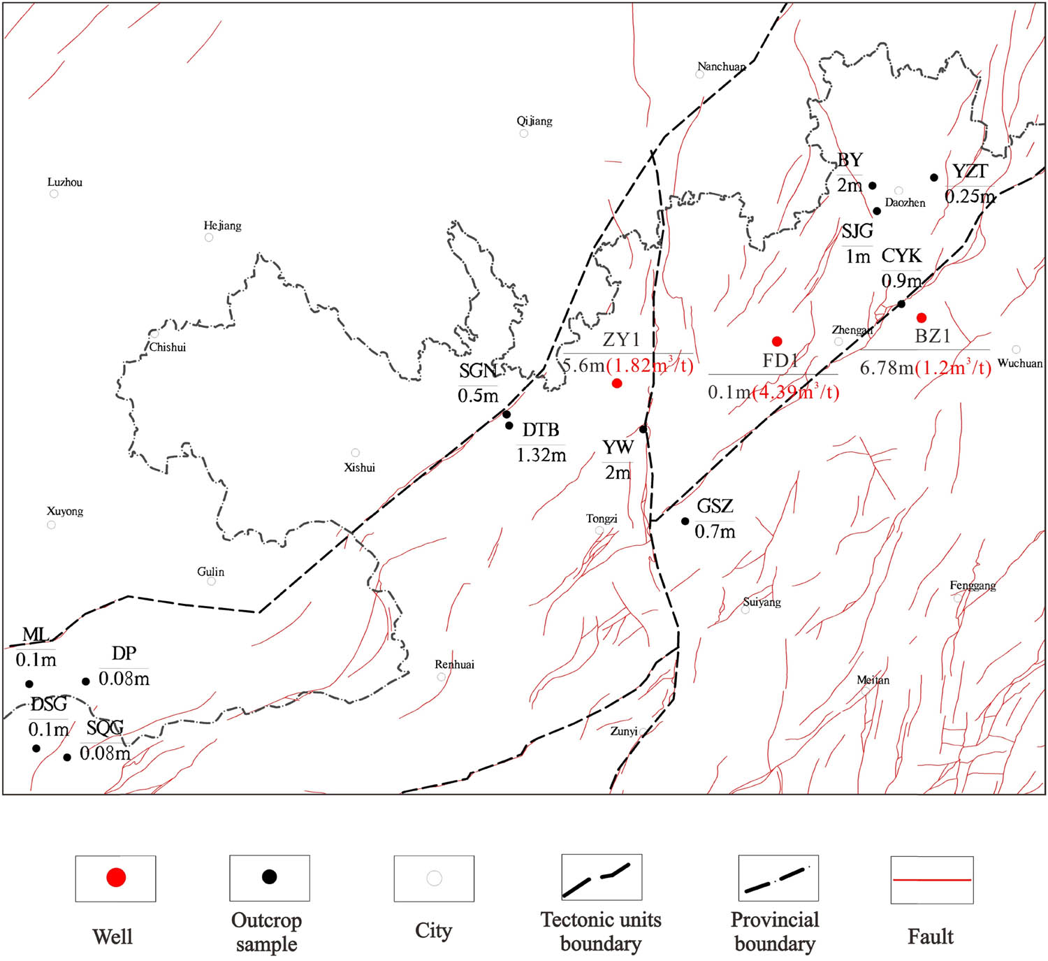
The northern Guizhou province is located in the southwestern part of the Upper Yangtze Platform, East of Jinsha-Qianxi-Luodian, and North of Anshun-Majiang-Tongren in the northern part of Guizhou. It is adjacent to the southeastern region of Chongqing and the western region of Hunan (Figure 1a). The main tectonic units in this area include the Central Guizhou Uplift, the Dianqianbei Depression, and the Wuling Depression, covering an area of approximately 78,600 km2.
![Figure 1
Structural geological map of northern Guizhou. (a) Tectonic location of the northern Guizhou (modified after Jiang et al. [33]), (b) geologic map of the northern Guizhou (modified after Feng et al. [7]), and (c) structural section of cross-section A-A’; the plane location is shown in (b). QYF – Qiyueshan, JS-PS – Jianshi-Pengshui, HF-LS – Hefeng-Longshan, KJ – Kaijiang, LC – Lichuan, ZY – Zhongyang, HGP – Huaguoping, and YD-HF – Yidu-hefeng (modified after Chen et al. [34]).](/document/doi/10.1515/geo-2022-0653/asset/graphic/j_geo-2022-0653_fig_001.jpg)
Structural geological map of northern Guizhou. (a) Tectonic location of the northern Guizhou (modified after Jiang et al. [33]), (b) geologic map of the northern Guizhou (modified after Feng et al. [7]), and (c) structural section of cross-section A-A’; the plane location is shown in (b). QYF – Qiyueshan, JS-PS – Jianshi-Pengshui, HF-LS – Hefeng-Longshan, KJ – Kaijiang, LC – Lichuan, ZY – Zhongyang, HGP – Huaguoping, and YD-HF – Yidu-hefeng (modified after Chen et al. [34]).
The geological formations in the northern Guizhou province range from Late Proterozoic to Cenozoic, formed under various sedimentary environments with different sedimentary compositions. These formations have experienced several evolutionary stages, including an active continental margin-stable platform (Late Middle Proterozoic to Silurian), an extensional subsidence basin (Devonian to Late Triassic), and a rift basin (Mesozoic to Cenozoic) [32]. The northern Guizhou province has experienced multiple tectonic movements starting from the Ordovician period. The Late Ordovician Douyun Movement and the Late Silurian Guangxi Movement played a significant role in controlling the formation of the Central Guizhou Uplift. During the Late Ordovician to Early Silurian, from the Wufengian to the Longmaxi period, a large-scale marine transgression occurred in the northern Guizhou province. It developed anoxic environments dominated by suspended sedimentation. This resulted in the continuous deposition of the Upper Ordovician Wufeng Formation to the Lower Silurian Longmaxi Formation.
The seawater gradually retreated from South to North during the early stage of the Longmaxi Formation. It made the depositional waters shallower and terrestrial clastics to influx continuously. As a result, the organic content of the upper Longmaxi Formation shale decreased with the increase of mud and sand content, and the sedimentation center shifted northward. Influenced by the Yanshanian tectonic cycle, the area underwent deformation and superimposed modifications and formed a “Jurassic mountain-type” fold-thrust belt primarily oriented in the NE–NNE direction. Three sets of mostly Late Caledonian compressional faults developed, oriented in NE, nearly SN, and nearly EW directions. These faults were later reactivated during the Yanshanian period, resulting in sinistral strike-slip movements and multiple detachment layers at different burial depths (Figure 1c). Additionally, with the local deformation adjustments during the Himalayan period, the NE–SW oriented fold structure was formed, forming the current structural morphology (Figure 1b).
3 Characteristics of the detachment layer
In this study, more than 10 profile points and drilling sites were analyzed. Samples were taken from the detachment layer and their overlying and underlying strata, as shown in Figure 1b. The detachment structures of distribution, scale, development horizon, deformation characteristics, and attitudes in the Wufeng-Longmaxi Formations were described and analyzed through field outcrop profile measurements and core observations (Table 1). The study revealed that the detachment layer is regional-scale structures in the Wufeng-Longmaxi Formations with thicknesses ranging from several centimeters to several meters.
Characteristics of the detachment layer of Wufeng-Longmaxi Formation, Northern Guizhou province
| Outcrop/well | Stratigraphic | Deformation characteristics of the detachment layer | Near fracture condition | Surrounding rock facies |
|---|---|---|---|---|
| BY | O3w | The detachment layer is 100–200 cm thick, interbedded with siliceous shale and carbonaceous shale, containing pyrite nodules and crumpled development | 3 km from the second-order fracture | Siliceous shale |
| YZT | O3w | The detachment layer is a 25 cm thick carbonaceous shale, has crumpled development, brecciation and fragmentation in the layer, and quartz veins in the layer | 3.5 km from the third-order fracture | Siliceous shale |
| CYK | O3w | The detachment layer is 90 cm thick, and the siliceous shale and carbonaceous shale are interbedded and crumpled | 0.5 km from the first-order fracture | Siliceous shale |
| SJG | O3w | The detachment layer is 100 cm thick and interbedded with siliceous shale and carbonaceous shale | 1.5 km from the second-order fracture | Nodular limestone and siliceous shale |
| HSZ | O3w | The detachment layer thickness is 70 cm, and the local detachment layer thickness is about 20 cm | 4.5 km from the first-order fracture | Siliceous shale |
| DSG | O3w | The detachment layer is a 2–8 cm thick carbon shale; pyrite and calcite veins developed | 3.3 km from the third-order fracture | Calcareous carbonaceous shale |
| QML | O3w | The lower detachment layer is a 1–3 cm thick carbonaceous shale; the upper detachment layer is a 60 m thick carbonaceous shale | 1 km from the third-order fracture | Carbonaceous shale |
| SQG | O3w | The detachment layer is a 10 cm thick carbonaceous shale; square veins are developed | 3 km from the third-order fracture | Carbonaceous shale |
| YW | O3w | The detachment layer is a 200 cm thick carbonaceous shale and has crumpled developments | 0.1 km from the first-order fracture | Carbonaceous shale |
| ML | S1l | The detachment layer is a 3–5 cm thick carbonaceous shale, with a detachment mirror, and the lower part contains pyrite | 10 km from the second-order fracture | Carbonaceous shale |
| DP | O3w | The lower detachment layer is a 10 cm thick carbon shale; the upper detachment layer is a 5–10 cm thick calcareous shale; pyrite and calcite veins developed | 7 km from the fourth-order fracture | Carbonaceous shale and calcareous shale |
| DTB | O3w | The detachment layer is 50–70 cm thick, interbedded with siliceous shale and carbonaceous shale, with pyrite bands, quartz, and calcite clumps, and specular scratches at the bottom | 3.5 km from the first-order fracture | Siliceous shale and carbonaceous shale |
| SGN | O3w | The detachment layer is of varying thickness, up to 50 cm thick and 3–5 cm thin, containing siliceous shale, quartz, and calcite veins | 1.5 km from the first-order fracture | Siliceous shale |
| ZY1 | O3w | The detachment layer is a 5.6 m thick carbonaceous shale and is crumpled and developed | 7.5 km from the first-order fracture | Carbonaceous shale |
| BZ1 | O3w | The detachment layer is a 6.78 m thick carbonaceous shale and is crumpled and developed | 5.5 km from the first-order fracture | Carbonaceous shale |
| FD1 | O3w | The detachment layer is a 10 cm thick carbonaceous shale | 6.5 km from the third-order fracture | Carbonaceous shale |
3.1 Lithological characteristics surrounding the structural detachment layers
The detachment layer mainly develops in the Ordovician Wufeng Formation to the Silurian Longmaxi Formation within the black organic-rich shale intervals. Notably, the interbedded sections of siliceous and carbonaceous shales in the Wufeng Formation are the most prominent. In the central-eastern part of the northern Guizhou province, the Wufeng Formation is dominated by siliceous shale. In the western part, it is dominated by calcareous shale. The significant difference indicating the depositional environment has changed in the western region.
In terms of surrounding rock characteristics, the predominant lithology is siliceous shale, while some field profile points or drilling locations show variations such as siliceous shale, carbonaceous shale, or nodular limestone. Table 1 indicates that there are noticeable changes in lithology between the surrounding rocks, such as siliceous shale and nodular limestone, and the detachment layer. It indicates that the detachment layer tend to occur and become thicker in lithological transitions.
In the profiles of Bayu, Yuxi Town, Daozhen County (BY), the detachment layer exhibits thrust-fold development and shale thickening in the fold transition zone, gradually thickening northwestward. The detachment layer is characterized by detachment and interleaved blocks (Figure 2a). In the profiles of Dapo, Moni Town, Xuyong County (DP), Shuiqinggou, Liangyan Town, Bijie City (SQG), and Yanwan, Xinzhan Town, Tongzi County (YW), the slippage layer has a high content of mud, and its occurrence is disarranged (Figure 2b, c, and d).
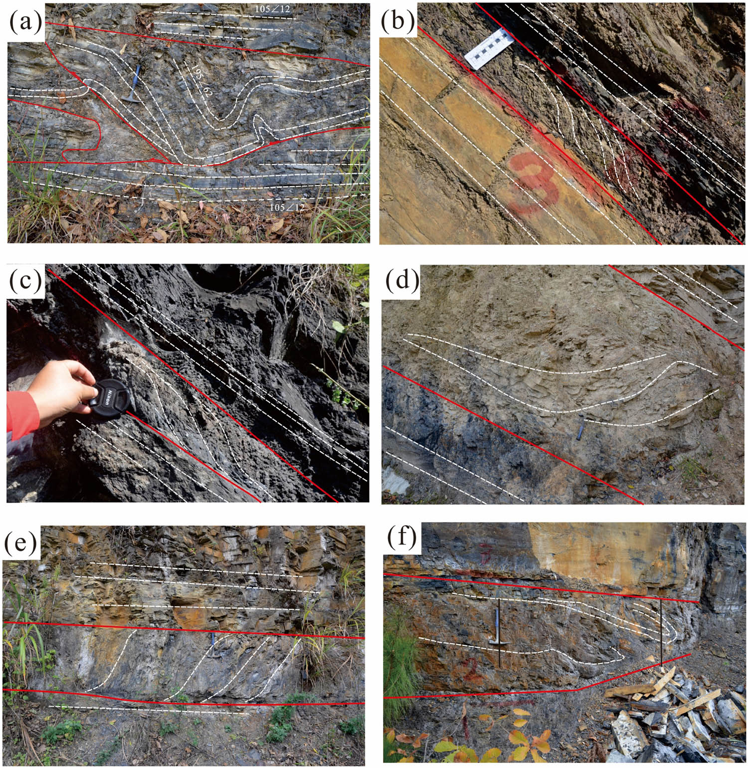
Decollement outcrop photos of Wufeng-Longmaxi Formation, Northern Guizhou: (a) BY, (b) DP, (c) SQG, (d) YW, (e) GSZ, and (f) DTB.
In the profiles of Qianshuzi, Kuangguan Town, Suiyang County (GSZ) and Datianba, Shuanglong Town, Xishui County (DTB), the siliceous shale within the fold structures experiences compression and fragmentation, forming lens-shaped features (Figure 2e and f). Additionally, the detachment layer is commonly filled with quartz or calcite veins between the detachment surfaces (Figure 2).
3.2 Spatial distribution characteristics of structural detachment layers
Detachment layers generally form at weak and low-strength layers with high strain. The detachment faults are commonly recognized as single faults or fault systems. Therefore, the spatial distribution characteristics of detachment layers are typically influenced by regional tectonic features in the northern Guizhou province [35]. The formation of fault structures mainly occurred during the Late Caledonian and Yanshanian periods. Its properties, scale, and characteristics of faults formed during each tectonic cycle show significant differences. It also indicates different impacts on the development of detachment layers. During the Late Caledonian tectonic cycle in this region, the uplifting tectonic movements were the main geological process. It formed large-scale uplifts and basins. During the late stage of the Late Caledonian period, relaxation led to the development of extensional normal fault systems. These types of faults have relatively short strike lengths and often form small-scale horst and graben combinations within a limited area. The tectonic activity in the region was dominated by extensional faulting during the Late Yanshanian period. Also, most of the faults in the northern Guizhou province were formed during this period. The main driving force for the formation of these faults was the compression and overthrust of the Xuefeng and Maguan thrust sheets.
Faults can be classified based on the magnitude of fault displacement, the displaced strata, the length of extension, and the controlling range. First-order faults are basin-controlling faults. Second-order faults are faults that control second-order tectonic units. Third-order faults are faults that control local structures. Fourth-order faults are short faults within local structures [14]. As shown in Table 1, the detachment layer in the Wufeng-Longmaxi Formations in the northern Guizhou province shows various characteristics.
First- and second-order faults are the main controlling factors for the thickness and deformation development of the detachment layer. In general, wild outcrop profiles and drilling sites located within approximately 8 km from first-order faults, which are basin-controlling faults, exhibit a thick detachment layer and severe deformation. Examples include the ZY1 well and the DTB (Figure 2f). Within 5 km of second-order faults, there are also wild outcrop profiles with a thicker and more severely deformed detachment layer, such as the BY (Figure 2a).
Third-order faults have a relatively limited influence on detachment occurrence, with a small-scale detachment layer occurring within 2–3 km from these faults. Examples include the SQG (Figure 2c). Fourth-order faults have less apparent disruptive effects, as observed in the FD1 well where only a 10 cm detachment layer was found in core observations. It shows that the detachment layer has greater thickness and stronger deformation in the vicinity of large fault zones. The areas have intense folding and deformation of rock strata. In addition, the detachment layer tends to be shorter in scale and exhibits weaker deformation in the regions, where faults are underdeveloped.
3.3 Mineralogical characteristics of the surrounding rocks of structural detachment layers
In this study, outcrop samples were collected from the Wufeng-Longmaxi Formations in the northern Guizhou province, including 19 samples of detachment layer and their hanging and footwall rocks. Additional, three samples were collected from each of the following locations: Yuanzitang, Yuxi Town, Daozhen County (YZT), BY, Shigenao, Shuanglong Town, Xishui County (SGN), and DTB. One sample of each was collected from GSZ, Changyakou, Zongping Town, Daozhen County (CYK), SQG, Dashuigou, Linkou Town, Bijie City (DSG), and ML.
The mineral composition of the collected samples was identified using X-ray diffraction, and volume percentage diagrams were drawn for the minerals. A ternary diagram of the mineral composition in the study area was also created. The minerals in the shale were categorized into three groups based on their properties: silicate minerals, carbonate minerals, and clay minerals.
3.3.1 Mineral content
In terms of mineral composition, the clay mineral content in the detachment layer of BY and SGN exceeds 80%, much higher than the clay mineral content in their respective hanging and footwall rocks (Figure 3). The mineral composition of the detachment layer in YZT and DTB is similar to their hanging and footwall rocks.
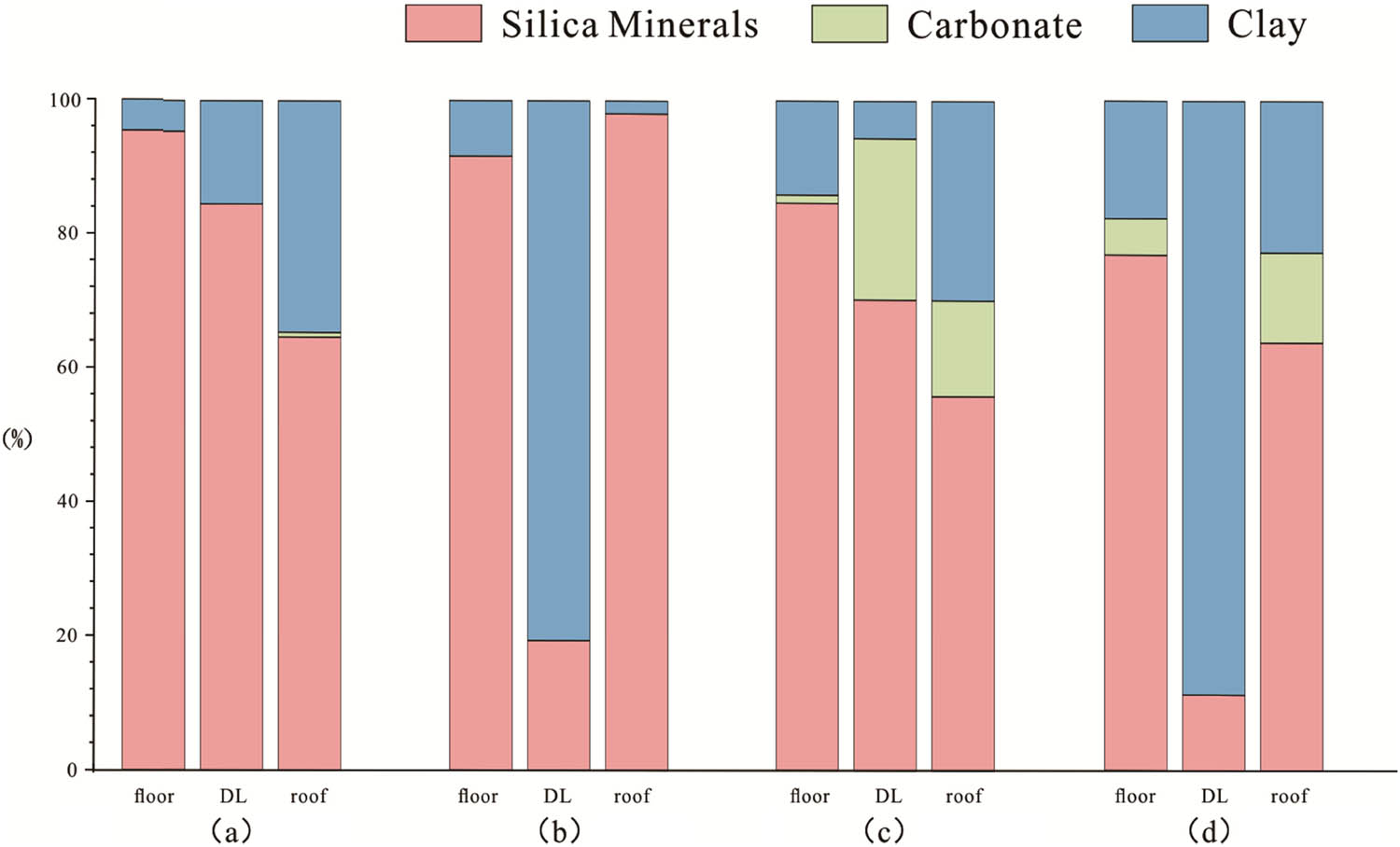
Percentage of mineral content in the detachment layer (DL) and its roof and floor of Wufeng-Longmaxi Formation in northern Guizhou: (a) YZT, (b) BY, (c) DTB, and (d) SGN.
Regarding thickness, the detachment layers in BY and SGN have thicknesses of 100–200 and 50 cm, respectively. The detachment layers in YZT and DTB have thicknesses of 25 and 150 cm, respectively. Table 1 indicates that the mineral composition and rock structure of shale directly influence its brittleness, thereby controlling the formation of structural detachment. The formation of detachment layers in the Wufeng-Longmaxi Formations is correlated with the thickness and mineral content of the hanging wall and footwall rocks. Specifically, the greater the difference in mineral content between the hanging wall and footwall rocks between the detachment layer, the more likely the detachment layer forms.
3.3.2 Lithofacies of the surrounding rocks of structural detachment layers
The lithofacies types in the study area are classified based on the ternary diagram of silica minerals (quartz + feldspar)–carbonate minerals–clay minerals (Figure 4). The percentage of each type of mineral is greater than 50%, which corresponds to the respective lithofacies combination (siliceous shale lithofacies combination, calcareous shale lithofacies combination, and clayey shale lithofacies combination); the percentage each type of mineral is less than 50% but greater than 25%, and it is classified as mixed shale lithofacies combination. Therefore, based on the 25, 50, and 75% content of the ternary elements, the above 4 shale lithofacies combinations can be further subdivided into 16 shale lithofacies types [36].

Three-end element diagram of mineral composition of detachment layer in the Wufeng-Longmaxi Formation in northern Guizhou. Siliceous shale lithofacies combination: S – siliceous shale lithofacies, S-1 – siliceous shale lithofacies with carbonate, S-2 – mixed siliceous shale lithofacies, and S-3 – siliceous shale lithofacies with clay. Calcareous shale lithofacies combination: C – calcareous shale lithofacies, C-1 – calcareous shale lithofacies with silica, C-2 – mixed calcareous shale lithofacies, and C-3 – calcareous shale lithofacies with clay. Clayey shale lithofacies combination: CM – clayey shale lithofacies, CM-1 – clayey shale lithofacies with silica, CM-2 – mixed clayey shale lithofacies, and CM-3 – clayey shale lithofacies with carbonate. Mixed shale lithofacies combination: M – mixed shale lithofacies, M-1 – mixed shale lithofacies with carbonate/silica, M-2 – mixed shale lithofacies with clay/silica, and M-3 – mixed shale lithofacies with clay/carbonate.
The Wufeng Formation and Longmaxi Formation of shale show five lithofacies combinations. Siliceous shale lithofacies combinations (siliceous shale lithofacies [S] and mixed siliceous shale lithofacies [S-2]), calcareous shale lithofacies combinations (calcareous shale lithofacies with silica [C-1] and mixed calcareous shale lithofacies [C-2]), and clayey shale lithofacies combination (clayey shale lithofacies [CM]).
Lithofacies of the detachment layer in the YZT is S. The thickness of the slip layer is 25 cm, and the outcrop shows developed folds, chaotic bedding, intra-layer brecciation, and fragmentation. Quartz veins are visible in the rock, with vein bodies measuring 1–2 cm in width and approximately 10 cm in length. It formed by later-stage filling fractures.
Lithofacies of the detachment layer in the ML and DTB are S-2. The thickness of the slip layer is 5 cm in ML and 50–70 cm in DTB. The outcrop mainly shows surface weathering with white salt crystal precipitation, weathered surface fragmentation, and visible slip surfaces. The yellow iron ore bands and calcite veins are present. Based on the relationships of vein bodies and faults, at least three stages of mineralization were observed.
Lithofacies of the detachment layer in the SQG and DSG are C-1. The thickness of the slip layer is 10 cm in SQG and 8 cm in DSG. The outcrop mainly shows chaotic deformation with developed calcite veins within the slip layer, having a width ranging from 0.1 to 2 mm.
Lithofacies of the detachment layer in the GSZ is C-2. The thickness of the slip layer is 70 cm. The localized slip layer is thinner and is approximately 20 cm thick. The outcrop mainly shows developed folding and chaotic geological occurrence.
Lithofacies of the detachment layer in the SGN, BY, and CYK is CM. The thickness of the slip layer is 50, 200, and 90 cm, respectively. The outcrop mainly shows internal folding, with the development of pyrite nodules within the slip layer. Quartz and calcite veins are also present within the slip layer. In the SGN, the weathered surface of the outcrop shows white crystal deposition and sulfur precipitation, while the rock surface has iron staining.
Therefore, the positive correlation between lithofacies types and slip layer thickness is explored in the study area (Figure 5). The lithofacies types of detachment layers show that S tends to have a thinner thickness, CM lithofacies types have a larger thickness, Calcareous Shale (C) has the thicknesses between the CM and S. It indicates that lithofacies type is one of the main factors influencing the variation in slip layer thickness.
Shale lithofacies paleogeographic map of the Wufeng Longmaxi Formation in the northern Guizhou region.
4 Discussion
Previous studies have shown that parameters such as structural deformation, burial depth, cap layer, natural gas composition, and formation pressure coefficient can reflect the preservation of shale gas [29,31,37,38]. The preservation of shale gas depends on the structural type and deformation intensity, the time of tectonic uplift, the change in the buried depth of the target layer, and the conditions of the cap layer. Shale gas content is the reflection of shale gas preservation results.
Different tectonic zones in the northern Guizhou province result in different shale gas preservation conditions due to different detachment layers, stress modes, fault and fracture characteristics, and deformation strength.
4.1 Logging response characteristics of the detachment layers
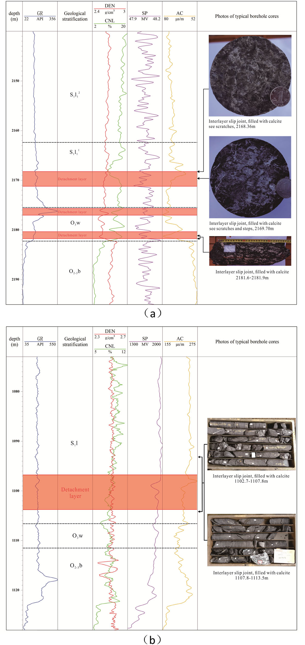
The detachment layers have obvious logging response characteristics. The natural gamma, sonic transit time, and density logging sensitive parameters can effectively analyze the lithology of the detachment layers and surrounding rocks [24]. Combined with core photographs and logging data, they indicate that the detachment layers have characteristics of low density and low natural gamma radiation anomalies in the Wufeng-Longmaxi Formation in the northern Guizhou province.
Within the depth range of 2,168–2,182 m in the well ZY 1 and 1,096–1,105 m in the well BZ 1, there were significant fluctuations in the sonic travel time, natural potential, and natural gamma values. Additionally, the density curve values also decreased suddenly, and the amplitudes of the well logging curves showed a sharp change, indicating a clear “frequency jump” phenomenon. The observations from the core samples confirmed the presence of shale interbed sliding fractures and calcite-filled fractures within this depth range. The cores have features such as slickensides and step-like structures (Figure 6). Comparing the logging responses of the Wufeng-Longmaxi Formation detachment layers in wells ZY 1 and BZ 1, it was observed that the acoustic transit time in well BZ 1 was significantly higher than that in well ZY 1 for the same detachment layer. However, in terms of natural gamma-ray values, the sliding layer in well BZ 1 was slightly lower than that in well ZY 1.
Comprehensive histogram of typical well Wufeng-Longmaxi Formation in northern Guizhou area: (a) well ZY 1 and (b) well BZ 1.
The comparison of typical well logging parameter values for the detachment layers in different wells indicates that the detachment layers show distinct differences in natural gamma-rays, spontaneous potential, and acoustic transit time due to variations in the sedimentary environment and tectonic activity, even at the same stratigraphic interval.
Thus, the development, thickness, and number of detachment layers in the Wufeng-Longmaxi Formation is different across the northern Guizhou province. Moreover, the well logging responses, particularly in terms of natural gamma-rays, spontaneous potential, and acoustic transit time, also show significant differences. These variations result in different oil and gas responses in logging characteristics in different regions.
4.2 Characteristics of nitrogen enrichment in detachment layers
The enrichment of nitrogen (N2) is primarily derived from the atmosphere, indicating the degree of connectivity between the subsurface and the surface. The degree is an direct indicator of the preservation conditions of oil and gas. Due to the scarcity of organic nitrogen elements, the organic nitrogen generated during the thermal cracking of hydrocarbons is generally less than 5% [38]. The core photos reveal the presence of multiple layers of sliding at depths between 2,168 and 2,182 m, with a total thickness of the sliding layer being 5.6 m. Also, the high nitrogen content of over 58% in well ZY 1 indicates significant influence from the sliding layer (Table 2 and Figure 6). The nitrogen content in well FD1 ranges from 0.71 to 3.84%, which is below 5%.
Gas group table of well ZY 1
| Report number | Component content (mol) (%) | |||||
|---|---|---|---|---|---|---|
| CH4 | C2–C6 | He | CO2 | N2 | Relative density | |
| 201910000150 | 36.6 | 0.164 | 0.0312 | 0.0579 | 58.2 | 0.8222 |
| 201910000154 | 36.3 | 0.163 | 0.0314 | 0.112 | 58.4 | 0.8251 |
| 201910000155 | 35.4 | 0.159 | 0.0308 | 0.107 | 59.2 | 0.8286 |
This suggests that the influence of the sliding layer is relatively short. Observations from well FD 1’s core photos reveal that the sliding layer is only 0.1 m thick (Table 3).
Gas group table of well FD 1
| Analysis number | Sample number | Component content (volume) (%) | |||||
|---|---|---|---|---|---|---|---|
| N2 | O2 | CO2 | CH4 | C2H6 | C3H8 | ||
| Y220806001 | FD1-3 | 1.29 | 0.16 | 0.19 | 96.13 | 2.2 | 0.03 |
| Y220806004 | FD1-6 | 3.84 | 0.56 | 0.39 | 93.58 | 1.61 | 0.02 |
| Y220806005 | FD1-7 | 2.29 | 0.23 | 0.27 | 95.26 | 1.93 | 0.02 |
| Y220806006 | FD1-8 | 1.37 | 0.15 | 0.18 | 96.17 | 2.1 | 0.03 |
| Y220806007 | FD1-9 | 1.27 | 0.18 | 0.22 | 96.32 | 1.98 | 0.03 |
| Y220806008 | FD1-10 | 1.04 | 0.13 | 0.19 | 96.44 | 2.17 | 0.03 |
| Y220806009 | FD1-11 | 1.48 | 0.22 | 0.24 | 96.15 | 1.89 | 0.02 |
| Y220806010 | FD1-12 | 0.95 | 0.12 | 0.16 | 97.31 | 1.45 | 0.01 |
| Y220806011 | FD1-13 | 3.25 | 0.36 | 0.26 | 94.94 | 1.18 | 0.01 |
| Y220806012 | FD1-14 | 2.16 | 0.24 | 0.24 | 95.92 | 1.42 | 0.02 |
| Y220806013 | FD1-15 | 0.87 | 0.12 | 0.19 | 96.84 | 1.96 | 0.02 |
| Y220806014 | FD1-16 | 0.71 | 0.07 | 0.16 | 97.35 | 1.69 | 0.02 |
| Y220806015 | FD1-17 | 2.53 | 0.34 | 0.21 | 95.39 | 1.52 | 0.01 |
From the core photos in well BZ 1, it can be seen that there is a slip zone at depths of 1106.5–1113.5 m (Figure 6). The gas composition chart of well BZ 1 shows that the gases are mainly composed of CH4 (methane) and N2 (nitrogen), with C2–C6 as secondary components. In the Xintan Formation, N2 is the dominant gas. Only a few samples show higher CH4 content. In the Longmaxi Formation, CH4 and N2 are the main gases. The CH4 percentage has averaging approximately 52% and shows an unclear variation pattern. The N2 content has an inverse relationship with CH4. In the Wufeng Formation, CH4 is the primary gas with an average percentage of 76.38% and N2 is present at approximately 22.4% (Figure 7). Therefore, it is inferred that the detachment fractures may allow atmospheric nitrogen gas to infiltrate into the shale gas. This results in poor gas content in the shale gas.
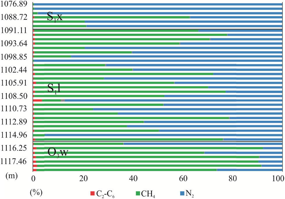
BZ 1 well natural gas composition percentage diagram. S1x – Silurian Xintan Formation , S1l – Silurian Longmaxi Formation, and O3w – Ordovician Wufeng Formation.
Therefore, by comparing the relationship between natural gas components and the gas content of shale gas in wells in the study area (Figure 8), it can be seen that the nitrogen content is negatively correlated with the gas content of shale gas. This indicates that atmospheric nitrogen gas infiltrates the shale gas, and the shale gas content shows a negative performance.
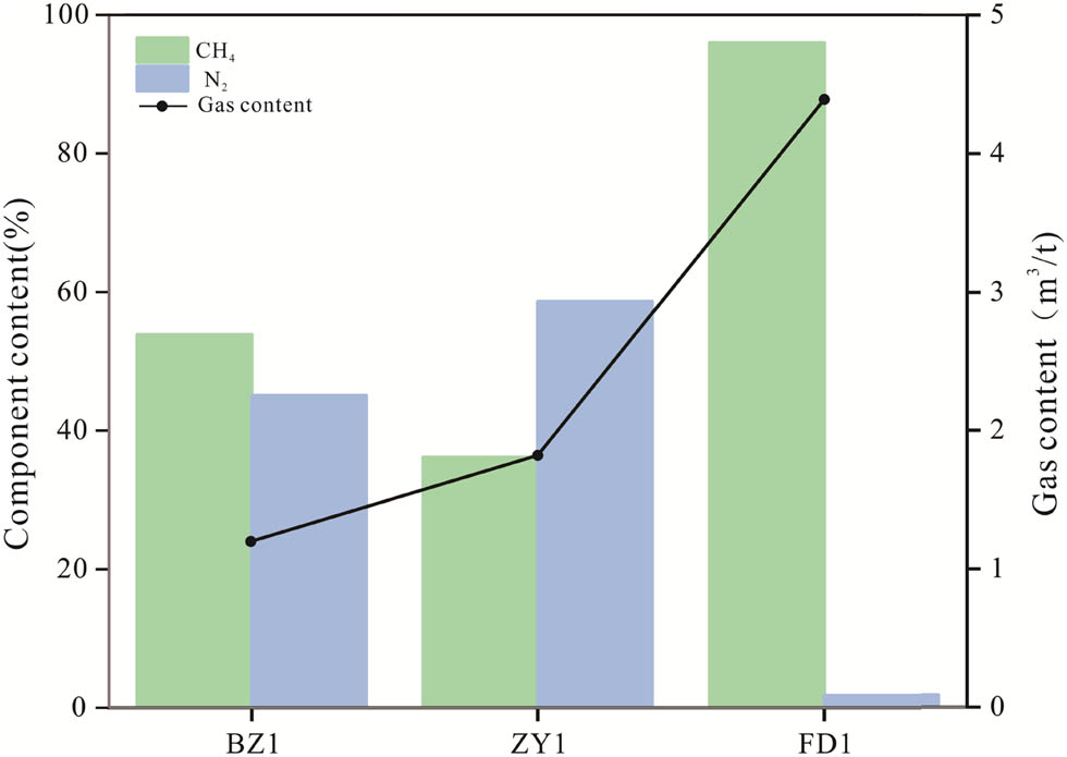
Natural gas composition and gas content map in northern Guizhou.
4.3 Mechanisms of slip zone influence
4.3.1 Field outcrop observation
The detachment zones have low-density characteristics and are characterized by the development of interlayer slip fractures. It has been demonstrated that the development of such interlayer detachment fractures can result in horizontal permeability in shale that is 2–8 times higher than the vertical permeability [26]. Shale gas is more prone to lateral diffusion within structure layers. In the field profile of SGN, the observation of salt frost and natural sulfur on the surface of the detachment zone also confirms that the permeability of the slip zone is higher than that of the surrounding roof and floor layers. It results in an easier lateral diffusion of shale gas. This could lead to a gradual decrease and even complete destruction of gas accumulation in the reservoir (Figure 9).
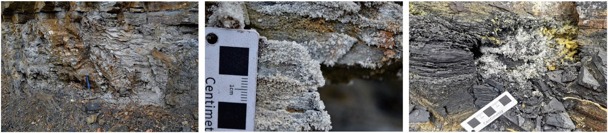
Salt frost and natural sulfur are precipitated on the surface of the detachment layer of SGN.
4.3.2 Characteristics of gas content in detachment layers
Detachment layers can significantly impact the permeability, diffusion coefficient, and desorption rate of shale gas. It could result in a decrease in the self-sealing ability of the shale. This has a noticeable effect on the gas content of the shale. For instance, in the wells ZY 1 and BZ 1 in the northern Guizhou province, the high-quality shale thickness is 26.5 and 20 m, respectively. The detachment layers have thicknesses of 5.6 and 6.78 m. But this only result in gas contents of 1.82 and 1.2 m3/t, respectively. On the other hand, in the well FD 1, although the high-quality shale thickness is thinner at 15.8 m, the detachment layer is only 0.1 m thick. It has a high gas reservoir of 4.39 m3/t (Figure 10 and Table 4).
Stratification thickness and gas content map of the northern Guizhou area.
Characteristic table of slippage layer thickness and gas content of shale gas wells, Northern Guizhou province
| Well | Burial depth (m) | Detachment thickness (m) | High-quality shale thickness (m) | Gas content (m3/t) |
|---|---|---|---|---|
| ZY1 | 2,182 | 5.6 | 26.5 | 1.82 |
| BZ1 | 1,130 | 6.78 | 20 | 1.2 |
| FD1 | 1,258 | 0.1 | 15.8 | 4.39 |
4.3.3 Influence of detachment layers in different structural positions
In the partitioned deformation belt, shale gas is generally well preserved, such as in Jiaoshiba area, where shale gas has been commercially discovered. The main structure of Jiaoshiba has a box-like anticline shape [29], the top is wide and slow, and the two wings are sharply inclined. Two groups of reverse faults developed in Northeast and near South to North are well sealed. In addition, it shows good preservation conditions with well top, bottom conditions, and an appropriate burial depth (more than 2,000 m).
In the slot-shift tape transition belt, faults and fractures are relatively developed. The tectonic deformation is relatively local, and the overall preservation conditions of shale gas are relatively poor. For example, the Songkan syncline where the well ZY 1 is located shows a typical inverse fault pattern of “hump depression” tectonic pattern. It has good lateral sealing capacity, moderate burial depth, and gentle geological characteristics, and no shale gas layers are exposed around the area [29]. However, due to the presence of the detachment layer and its proximity to the Zunyi fault zone, shale gas migrates along the fractured zone formed by the sliding layer to the Zunyi fault zone (Figure 11a). The syncline geological structure in FD 1 well is a denudation residual syncline structure, and the syncline is wide and slow. There is a certain distance from the synclinal Tongtian fault, barely faults are developed, and the slippage deformation stress is weak under compression. Therefore, the general state of preservation is favorable (Figure 11b).
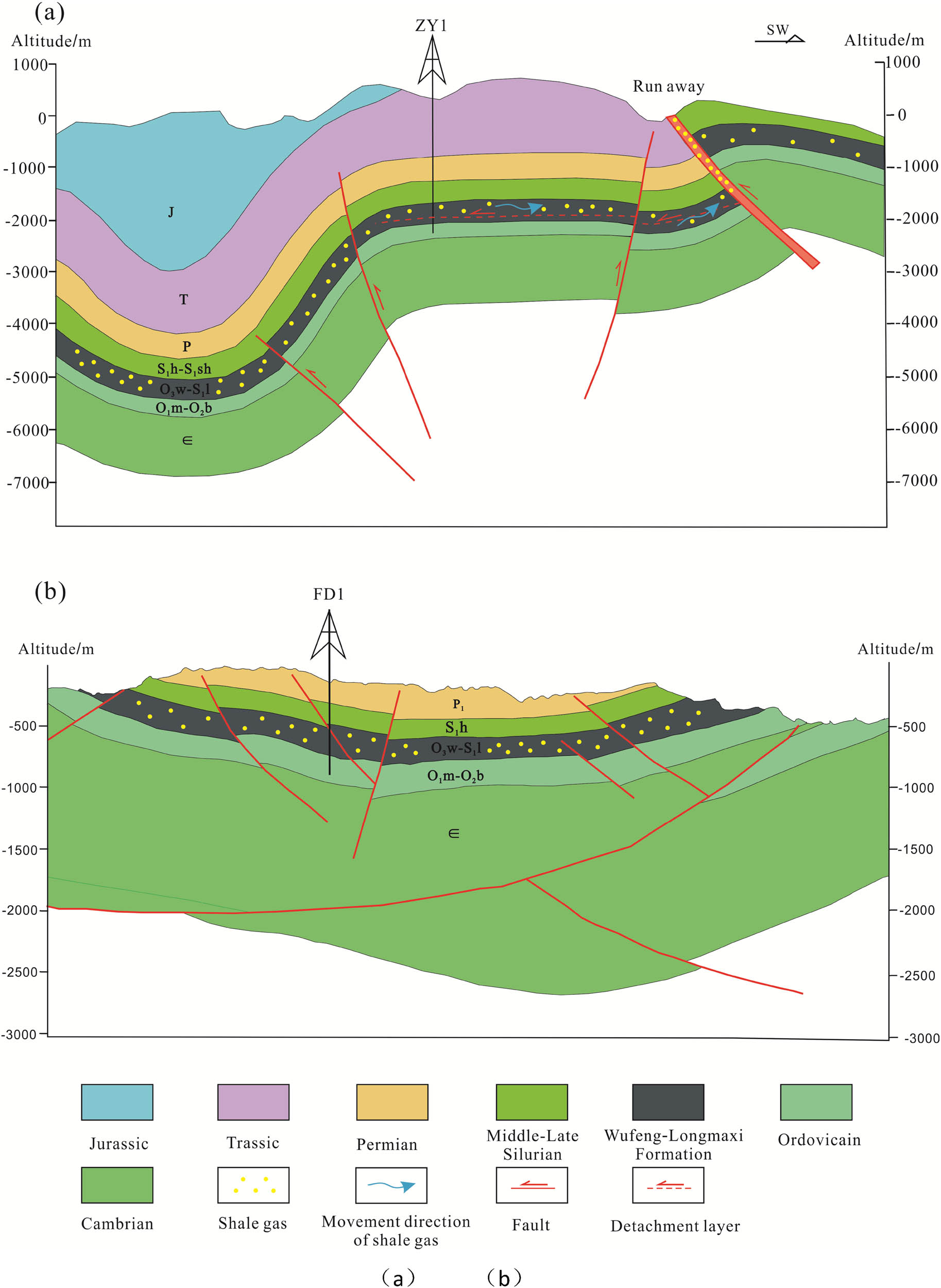
Schematic diagram of the detachment structure influence on shale gas preservation in the Wufeng-Longmaxi Formation, Northern Guizhou: (a) ZY1 and (b) FD1.
In the spacer-type deformation belt, thrust and inverted syncline are mostly developed, and the syncline is tight, narrow, and long. The structure is seriously denudated, the burial depth is shallow, and the syncline internal faults are developed. It results in the dislocation of the syncline strata and poor boundary sealing ability, such as the Banzhu syncline where the well BZ1 is located has a buried depth of about 1,200 m and a large stratigraphic dip (37–48°). The depth of burial and the degree of structural deformation are unfavorable to the preservation of shale gas. In addition, affected by the slip structure and the thinning of high-quality shale, the preservation conditions are poor.
The reasons for the difference in shale gas content distribution are structural type and deformation intensity, tectonic uplift time, buried depth of target layer, cap layer conditions, and so on. The detachment layer plays an important role in the area where the geological structure is exposed to the surface or near the “through-going” faults, and the separation layer forms an important way of gas migration in the shale. These paths are called “fracture zones,” and they direct critical passageways for gas to escape; in this case, shale gas is still escaping from protected areas. However, the area buried deep, faults and fractures are not developed, and well formation occurs. The detachment layer development is hard to affect the preservation of shale gas.
5 Conclusions
The Wufeng-Longmaxi Formation detachment layers have the following developmental characteristics: (a) the detachment layers formed have greater thickness when the surrounding rock lithology shows significant changes or belongs to siliceous shale and nodular limestone. (b) Detachment layers show greater thickness and intense rock deformation in the vicinity of large thrust fault zones and areas with strong stratigraphic folding deformation. Conversely, the detachment layers are shorter in scale and have weaker deformation, whereas faults are less developed. (c) Detachment layers with lithology characterized by siliceous shale show thinner thicknesses. The characterized clayey shale has a higher thickness.
Detachment layers show distinctive well logging and seismic response characteristics. Acoustic impedance and density logging are preferred parameters for effectively distinguishing internal lithology and surrounding rocks. The development of detachment fractures allows atmospheric nitrogen to infiltrate shale gas. It results in poor gas saturation in the shale gas.
The overall tectonic deformation in the northern Guizhou province was gradually intense from Northwest to Southeast, and the influence of detachment layer on shale gas preservation in the northern Guizhou province is limited. It is mainly controlled by the buried depth of the target layer, conditions of the cover layer, structural type, and deformation intensity.
Acknowledgements
The authors gratefully acknowledge support for this research provided by the Science and Technology Planned Project in Guizhou Province (Qian Kehe Support [2020]4Y037 and Qian Kehe Strategic Mining [2022]ZD005).
-
Funding information: This research was supported by the Science and Technology Planned Project in Guizhou Province (Qian Kehe Support [2020]4Y037 and Qian Kehe Strategic Mining [2022]ZD005). The authors gratefully acknowledge its financial support.
-
Author contributions: Conceptualization: Sheng Shi and Ganlu Wang. Methodology: Sheng Shi. Formal analysis: Sheng Shi and Xiqiong Xiang. Investigation: Sheng Shi and Yuliang Mou. Resources: Xiangfeng Wei. Writing – original draft preparation: Sheng Shi. Writing – review and editing: Ganlu Wang, Xiqiong Xiang, and Xiangfeng Wei. Validation: Yuliang Mou. Visualization: Sheng Shi.
-
Conflict of interest: The authors declared no potential conflicts of interest with respect to the research, authorship, and/or publication of this article.
-
Data availability statement: The data presented in this study are available on request from the corresponding author. The data are not publicly available due to commercial reasons.
References
[1] Soeder DJ. The successful development of gas and oil resources from shales in North America. J Pet Sci Eng. 2018;S0920410517310471.10.4172/2157-7463-C1-039Search in Google Scholar
[2] Ghazwani A, Littke R, Gaus G, Hartkopf-Fröder C. Assessment of unconventional shale gas potential of organic-rich Mississippian and Lower Pennsylvanian sediments in western Germany. Int J Coal Geol. 2018;198:29–47.10.1016/j.coal.2018.08.008Search in Google Scholar
[3] Ferrill DA, McGinnis RN, Morris AP, Smart KJ, Sickmann ZT, Bentz M, et al. Control of mechanical stratigraphy on bed-restricted jointing and normal faulting: Eagle Ford Formation, south-central Texas. Aapg Bull. 2014;98:1–30.10.1306/08191414053Search in Google Scholar
[4] Xiong L, Liu Y, Shi D. Research on the Tectonic Evolution of the North Africa from Morocco to Libya as the Controlling Factor on the petroleum basins’ Hydrocarbon Accumulation. SPE/AAPG Africa Energy and Technology Conference OnePetro; 2016.Search in Google Scholar
[5] Zeng W, Zhang J, Ding W, Zhao S, Zhang Y, Liu Z, et al. Fracture development in Paleozoic shale of Chongqing area (South China). Part one: Fracture characteristics and comparative analysis of main controlling factors. J Asian Earth Sci. 2013;75:251–66.10.1016/j.jseaes.2013.07.014Search in Google Scholar
[6] Li C, Ou C. Modes of shale-gas enrichment controlled by tectonic evolution. Acta Geol Sinica(English Ed). 2018;92(5):1934–47.10.1111/1755-6724.13686Search in Google Scholar
[7] Feng Q, Qiu N, Borjigin T, Li F, Ji R, Liu X, et al. Effect of tectonic reworking on shale fracturing and gas preservation in the upper Yangtze block, south China. Mar Pet Geol. 2023;148:106069.10.1016/j.marpetgeo.2022.106069Search in Google Scholar
[8] Curtis JB. Fractured shale-gas systems. AAPG Bull. 2002;86(11):1921–38.10.1306/61EEDDBE-173E-11D7-8645000102C1865DSearch in Google Scholar
[9] Stevens SH, Moodhe KD, Kuuskraa VA. China shale gas and shale oil resource evaluation and technical challenges. SPE Asia Pacific Oil and Gas Conference and Exhibition OnePetro; 2013.10.2118/165832-MSSearch in Google Scholar
[10] Gale JF, Laubach SE, Olson JE, Eichhubl P, Fall A. Natural fractures in shale: A review and new observations. AAPG Bull. 2014;98(11):2165–216.10.1306/08121413151Search in Google Scholar
[11] Nabiei M, Yazdjerdi K, Soleimany B, Asadi A. Role of Multiple Décollement Horizons in the Structural Style of the Sefid-Zakhur Anticline in the Fars Province, Zagros Belt. Geotectonics. 2021;55(3):408–22.10.1134/S0016852121030067Search in Google Scholar
[12] He Z, Nie H, Li S, Luo J, Wang H, Zhang G. Differential enrichment of shale gas in upper Ordovician and lower Silurian controlled by the plate tectonics of the Middle-Upper Yangtze, south China – ScienceDirect. Mar Pet Geol. 2020;118:104357.10.1016/j.marpetgeo.2020.104357Search in Google Scholar
[13] Li S, Li Y, He Z, Chen K, Zhou Y, Yan D. Differential deformation on two sides of Qiyueshan Fault along the eastern margin of Sichuan Basin, China, and its influence on shale gas preservation. Mar Pet Geol. 2020;121:104602.10.1016/j.marpetgeo.2020.104602Search in Google Scholar
[14] Shi X, Wu W, Shi Y, Jiang Z, Zeng L, Ma S, et al. Influence of multi-period tectonic movement and faults on shale gas enrichment in Luzhou Area of Sichuan Basin, China. Energies. 2022;15(18):6846.10.3390/en15186846Search in Google Scholar
[15] Liu CQ, Zhou JX, Lang J. Study on restrictive factor of fold-thrust belt formation with multiple decollements: Taking Eastern Sichuan-Xuefeng tectonic belt as an example. J Earth Sci Environ. 2013;35(2):45–55.Search in Google Scholar
[16] Rich JL. Mechanics of low-angle overthrust faulting as illustrated by Cumberland thrust block, Virginia, Kentucky and Tennessee. AAPG Bull. 1934;18:1584–96.10.1306/3D932C94-16B1-11D7-8645000102C1865DSearch in Google Scholar
[17] Bahroudi A, Koyi HA. Effect of spatial distribution of Hormuz salt on deformation style in the Zagros fold and thrust belt: an analogue modelling approach. J Geol Soc. 2003;160(5):719–9.10.1144/0016-764902-135Search in Google Scholar
[18] Vergés J, Goodarzi MGH, Emami H, Karpuz R, Efstathiou J, Gillespie P. Multiple detachment folding in Pusht-e Kuh arc. AAPG Mem. 2011;94:69–94.Search in Google Scholar
[19] Costa E, Vendeville BC. Experimental insights on the geometry and kinematics of fold-and-thrust belts above weak,viscous evaporitic decollement. J Struct Geol. 2002;24(11):1729–39.10.1016/S0191-8141(01)00169-9Search in Google Scholar
[20] Harris LB, Yakymchuk C, Godin L. Implications of centrifuge simulations of channel flow for opening out or destruction of folds. Tectonophysics. 2012;526–529:67–87.10.1016/j.tecto.2011.05.002Search in Google Scholar
[21] Wissing SB, Ellis S, Pfiffner OA. Numerical models of Alpine-type cover nappes. Tectonophysics. 2003;367(3–4):145–72.10.1016/S0040-1951(03)00097-0Search in Google Scholar
[22] Li C, Yin H, Wu Z, Zhou P, Wang W, Ren R, et al. Effects of salt thickness on the structural deformation of foreland fold-and-thrust belt in the Kuqa Depression, Tarim Basin: Insights from discrete element models. Front Earth Sci. 2021;9:655173.10.3389/feart.2021.655173Search in Google Scholar
[23] Lianbo Z, Benming L. Abnormal high pressure in Kuqa foreland thrust belt of Tarim basin: Origin and impacts on hydrocarbon accumulation. Prog Nat Sci. 2006;16(12):1307–14.10.1080/10020070612330146Search in Google Scholar
[24] Zhou L, Zhang X, Wu Y, He D. A study on the characteristics of deformation with multilevel detachment in East Sichuan Basin based on seismic data. SEG Technical Program Expanded Abstracts 2018. China: Society of Exploration Geophysicists; 2018. p. 1723–7.10.1190/segam2018-2998127.1Search in Google Scholar
[25] Zamani B. Geodynamics and tectonic stress model for the Zagros fold–thrust belt and classification of tectonic stress regimes. Mar Pet Geol. 2023;155:106340.10.1016/j.marpetgeo.2023.106340Search in Google Scholar
[26] Ge X, Hu W, Ma Y, Li M, Tang J, Zhao P. Quantitative evaluation of geological conditions for shale gas preservation based on vertical and lateral constraints in the Songkan area, Northern Guizhou, southern China. Mar Pet Geol. 2021;124:104787.10.1016/j.marpetgeo.2020.104787Search in Google Scholar
[27] He S, Qin Q, Li H, Wang S. Deformation differences in complex structural areas in the southern Sichuan Basin and its influence on shale gas preservation: a case study of Changning and Luzhou areas. Front Earth Sci. 2022;9:818534.10.3389/feart.2021.818534Search in Google Scholar
[28] Shi Y, Tang X, Wu W, Jiang Z, Xiang S, Wang M, et al. Control of complex structural deformation and fractures on shale gas enrichment in southern Sichuan Basin, China. Energy Fuels. 2022;36(12):6229–42.10.1021/acs.energyfuels.2c00993Search in Google Scholar
[29] Hu D. Main controlling factors on normal pressure shale gas enrichments in Wufeng-Longmaxi formations in synclines, southeastern Sichuan Basin. Nat Gas Geosci. 2019;30(5):605–15 Chinese.Search in Google Scholar
[30] Zhao J, Ren L, Jiang T, Hu D, Wu L, Wu J, et al. Ten years of gas shale fracturing in China: Review and prospect. Nat Gas Ind B. 2022;9(2):158–75.10.1016/j.ngib.2022.03.002Search in Google Scholar
[31] Guo X, Cai X, Liu J, Liu C, Cheng Z, Gao B, et al. Natural gas exploration progress of sinopec during the 13th Five-Year Plan and prospect forecast during the 14th Five-Year Plan. Nat Gas Ind B. 2022;9(2):107–18.10.1016/j.ngib.2021.08.022Search in Google Scholar
[32] Lu H, Zhao A, Tang H, Lu L, Jiang L. Pore characterization and its controlling factors in the Wufeng-Longmaxi shale of North Guizhou, Southwest China. Energy Fuels. 2020;34(12):15763–72.10.1021/acs.energyfuels.0c02169Search in Google Scholar
[33] Jiang G, Hu S, Shi Y, Zhang C, Wang Z, Hu D. Terrestrial heat flow of continental China: Updated dataset and tectonic implications. Tectonophysics. 2019;753:36–48.10.1016/j.tecto.2019.01.006Search in Google Scholar
[34] Chen K, Zhang D, Tuo X. Relationship between geological structure and marine shale gas preservation conditions in the western Middle Yangtze Block. Nat Gas Ind B. 2020;7(6):583–93.10.1016/j.ngib.2020.04.002Search in Google Scholar
[35] Zhang Y, Du D. The decollement with the evolution of crust – kinetic and dynamic modes. J Nanjing University(Natural Sci). 1989;1:74–82 Chinese.Search in Google Scholar
[36] Wu L, Hu D, Lu Y, Liu R, Liu X. Advantageous shale lithofacies of Wufeng Formation-Longmaxi Formation in Fuling gas field of Sichuan Basin, SW China. Pet Explor Dev. 2016;43(2):208–17 Chinese.10.1016/S1876-3804(16)30024-6Search in Google Scholar
[37] Du W, Yang W, Li X, Shi F, Lin R, Wang Y, et al. Differential reservoir-forming mechanisms of the Lower Paleozoic Wufeng-Longmaxi and Niutitang Marine gas shales in Northern Guizhou Province, SW China: Theories and models. Energies. 2022;15(14):5137.10.3390/en15145137Search in Google Scholar
[38] Chen A. Nitrogen as an index of oil-gas preservation conditions in marine strata. Pet Geol Expeximent. 2005;27(1):85–9 Chinese.Search in Google Scholar
© 2024 the author(s), published by De Gruyter
This work is licensed under the Creative Commons Attribution 4.0 International License.
Articles in the same Issue
- Regular Articles
- Theoretical magnetotelluric response of stratiform earth consisting of alternative homogeneous and transitional layers
- The research of common drought indexes for the application to the drought monitoring in the region of Jin Sha river
- Evolutionary game analysis of government, businesses, and consumers in high-standard farmland low-carbon construction
- On the use of low-frequency passive seismic as a direct hydrocarbon indicator: A case study at Banyubang oil field, Indonesia
- Water transportation planning in connection with extreme weather conditions; case study – Port of Novi Sad, Serbia
- Zircon U–Pb ages of the Paleozoic volcaniclastic strata in the Junggar Basin, NW China
- Monitoring of mangrove forests vegetation based on optical versus microwave data: A case study western coast of Saudi Arabia
- Microfacies analysis of marine shale: A case study of the shales of the Wufeng–Longmaxi formation in the western Chongqing, Sichuan Basin, China
- Multisource remote sensing image fusion processing in plateau seismic region feature information extraction and application analysis – An example of the Menyuan Ms6.9 earthquake on January 8, 2022
- Identification of magnetic mineralogy and paleo-flow direction of the Miocene-quaternary volcanic products in the north of Lake Van, Eastern Turkey
- Impact of fully rotating steel casing bored pile on adjacent tunnels
- Adolescents’ consumption intentions toward leisure tourism in high-risk leisure environments in riverine areas
- Petrogenesis of Jurassic granitic rocks in South China Block: Implications for events related to subduction of Paleo-Pacific plate
- Differences in urban daytime and night block vitality based on mobile phone signaling data: A case study of Kunming’s urban district
- Random forest and artificial neural network-based tsunami forests classification using data fusion of Sentinel-2 and Airbus Vision-1 satellites: A case study of Garhi Chandan, Pakistan
- Integrated geophysical approach for detection and size-geometry characterization of a multiscale karst system in carbonate units, semiarid Brazil
- Spatial and temporal changes in ecosystem services value and analysis of driving factors in the Yangtze River Delta Region
- Deep fault sliding rates for Ka-Ping block of Xinjiang based on repeating earthquakes
- Improved deep learning segmentation of outdoor point clouds with different sampling strategies and using intensities
- Platform margin belt structure and sedimentation characteristics of Changxing Formation reefs on both sides of the Kaijiang-Liangping trough, eastern Sichuan Basin, China
- Enhancing attapulgite and cement-modified loess for effective landfill lining: A study on seepage prevention and Cu/Pb ion adsorption
- Flood risk assessment, a case study in an arid environment of Southeast Morocco
- Lower limits of physical properties and classification evaluation criteria of the tight reservoir in the Ahe Formation in the Dibei Area of the Kuqa depression
- Evaluation of Viaducts’ contribution to road network accessibility in the Yunnan–Guizhou area based on the node deletion method
- Permian tectonic switch of the southern Central Asian Orogenic Belt: Constraints from magmatism in the southern Alxa region, NW China
- Element geochemical differences in lower Cambrian black shales with hydrothermal sedimentation in the Yangtze block, South China
- Three-dimensional finite-memory quasi-Newton inversion of the magnetotelluric based on unstructured grids
- Obliquity-paced summer monsoon from the Shilou red clay section on the eastern Chinese Loess Plateau
- Classification and logging identification of reservoir space near the upper Ordovician pinch-out line in Tahe Oilfield
- Ultra-deep channel sand body target recognition method based on improved deep learning under UAV cluster
- New formula to determine flyrock distance on sedimentary rocks with low strength
- Assessing the ecological security of tourism in Northeast China
- Effective reservoir identification and sweet spot prediction in Chang 8 Member tight oil reservoirs in Huanjiang area, Ordos Basin
- Detecting heterogeneity of spatial accessibility to sports facilities for adolescents at fine scale: A case study in Changsha, China
- Effects of freeze–thaw cycles on soil nutrients by soft rock and sand remodeling
- Vibration prediction with a method based on the absorption property of blast-induced seismic waves: A case study
- A new look at the geodynamic development of the Ediacaran–early Cambrian forearc basalts of the Tannuola-Khamsara Island Arc (Central Asia, Russia): Conclusions from geological, geochemical, and Nd-isotope data
- Spatio-temporal analysis of the driving factors of urban land use expansion in China: A study of the Yangtze River Delta region
- Selection of Euler deconvolution solutions using the enhanced horizontal gradient and stable vertical differentiation
- Phase change of the Ordovician hydrocarbon in the Tarim Basin: A case study from the Halahatang–Shunbei area
- Using interpretative structure model and analytical network process for optimum site selection of airport locations in Delta Egypt
- Geochemistry of magnetite from Fe-skarn deposits along the central Loei Fold Belt, Thailand
- Functional typology of settlements in the Srem region, Serbia
- Hunger Games Search for the elucidation of gravity anomalies with application to geothermal energy investigations and volcanic activity studies
- Addressing incomplete tile phenomena in image tiling: Introducing the grid six-intersection model
- Evaluation and control model for resilience of water resource building system based on fuzzy comprehensive evaluation method and its application
- MIF and AHP methods for delineation of groundwater potential zones using remote sensing and GIS techniques in Tirunelveli, Tenkasi District, India
- New database for the estimation of dynamic coefficient of friction of snow
- Measuring urban growth dynamics: A study in Hue city, Vietnam
- Comparative models of support-vector machine, multilayer perceptron, and decision tree predication approaches for landslide susceptibility analysis
- Experimental study on the influence of clay content on the shear strength of silty soil and mechanism analysis
- Geosite assessment as a contribution to the sustainable development of Babušnica, Serbia
- Using fuzzy analytical hierarchy process for road transportation services management based on remote sensing and GIS technology
- Accumulation mechanism of multi-type unconventional oil and gas reservoirs in Northern China: Taking Hari Sag of the Yin’e Basin as an example
- TOC prediction of source rocks based on the convolutional neural network and logging curves – A case study of Pinghu Formation in Xihu Sag
- A method for fast detection of wind farms from remote sensing images using deep learning and geospatial analysis
- Spatial distribution and driving factors of karst rocky desertification in Southwest China based on GIS and geodetector
- Physicochemical and mineralogical composition studies of clays from Share and Tshonga areas, Northern Bida Basin, Nigeria: Implications for Geophagia
- Geochemical sedimentary records of eutrophication and environmental change in Chaohu Lake, East China
- Research progress of freeze–thaw rock using bibliometric analysis
- Mixed irrigation affects the composition and diversity of the soil bacterial community
- Examining the swelling potential of cohesive soils with high plasticity according to their index properties using GIS
- Geological genesis and identification of high-porosity and low-permeability sandstones in the Cretaceous Bashkirchik Formation, northern Tarim Basin
- Usability of PPGIS tools exemplified by geodiscussion – a tool for public participation in shaping public space
- Efficient development technology of Upper Paleozoic Lower Shihezi tight sandstone gas reservoir in northeastern Ordos Basin
- Assessment of soil resources of agricultural landscapes in Turkestan region of the Republic of Kazakhstan based on agrochemical indexes
- Evaluating the impact of DEM interpolation algorithms on relief index for soil resource management
- Petrogenetic relationship between plutonic and subvolcanic rocks in the Jurassic Shuikoushan complex, South China
- A novel workflow for shale lithology identification – A case study in the Gulong Depression, Songliao Basin, China
- Characteristics and main controlling factors of dolomite reservoirs in Fei-3 Member of Feixianguan Formation of Lower Triassic, Puguang area
- Impact of high-speed railway network on county-level accessibility and economic linkage in Jiangxi Province, China: A spatio-temporal data analysis
- Estimation model of wild fractional vegetation cover based on RGB vegetation index and its application
- Lithofacies, petrography, and geochemistry of the Lamphun oceanic plate stratigraphy: As a record of the subduction history of Paleo-Tethys in Chiang Mai-Chiang Rai Suture Zone of Thailand
- Structural features and tectonic activity of the Weihe Fault, central China
- Application of the wavelet transform and Hilbert–Huang transform in stratigraphic sequence division of Jurassic Shaximiao Formation in Southwest Sichuan Basin
- Structural detachment influences the shale gas preservation in the Wufeng-Longmaxi Formation, Northern Guizhou Province
- Distribution law of Chang 7 Member tight oil in the western Ordos Basin based on geological, logging and numerical simulation techniques
- Evaluation of alteration in the geothermal province west of Cappadocia, Türkiye: Mineralogical, petrographical, geochemical, and remote sensing data
- Numerical modeling of site response at large strains with simplified nonlinear models: Application to Lotung seismic array
- Quantitative characterization of granite failure intensity under dynamic disturbance from energy standpoint
- Characteristics of debris flow dynamics and prediction of the hazardous area in Bangou Village, Yanqing District, Beijing, China
- Rockfall mapping and susceptibility evaluation based on UAV high-resolution imagery and support vector machine method
- Statistical comparison analysis of different real-time kinematic methods for the development of photogrammetric products: CORS-RTK, CORS-RTK + PPK, RTK-DRTK2, and RTK + DRTK2 + GCP
- Hydrogeological mapping of fracture networks using earth observation data to improve rainfall–runoff modeling in arid mountains, Saudi Arabia
- Petrography and geochemistry of pegmatite and leucogranite of Ntega-Marangara area, Burundi, in relation to rare metal mineralisation
- Prediction of formation fracture pressure based on reinforcement learning and XGBoost
- Hazard zonation for potential earthquake-induced landslide in the eastern East Kunlun fault zone
- Monitoring water infiltration in multiple layers of sandstone coal mining model with cracks using ERT
- Study of the patterns of ice lake variation and the factors influencing these changes in the western Nyingchi area
- Productive conservation at the landslide prone area under the threat of rapid land cover changes
- Sedimentary processes and patterns in deposits corresponding to freshwater lake-facies of hyperpycnal flow – An experimental study based on flume depositional simulations
- Study on time-dependent injectability evaluation of mudstone considering the self-healing effect
- Detection of objects with diverse geometric shapes in GPR images using deep-learning methods
- Behavior of trace metals in sedimentary cores from marine and lacustrine environments in Algeria
- Spatiotemporal variation pattern and spatial coupling relationship between NDVI and LST in Mu Us Sandy Land
- Formation mechanism and oil-bearing properties of gravity flow sand body of Chang 63 sub-member of Yanchang Formation in Huaqing area, Ordos Basin
- Diagenesis of marine-continental transitional shale from the Upper Permian Longtan Formation in southern Sichuan Basin, China
- Vertical high-velocity structures and seismic activity in western Shandong Rise, China: Case study inspired by double-difference seismic tomography
- Spatial coupling relationship between metamorphic core complex and gold deposits: Constraints from geophysical electromagnetics
- Disparities in the geospatial allocation of public facilities from the perspective of living circles
- Research on spatial correlation structure of war heritage based on field theory. A case study of Jinzhai County, China
- Formation mechanisms of Qiaoba-Zhongdu Danxia landforms in southwestern Sichuan Province, China
- Magnetic data interpretation: Implication for structure and hydrocarbon potentiality at Delta Wadi Diit, Southeastern Egypt
- Deeply buried clastic rock diagenesis evolution mechanism of Dongdaohaizi sag in the center of Junggar fault basin, Northwest China
- Application of LS-RAPID to simulate the motion of two contrasting landslides triggered by earthquakes
- The new insight of tectonic setting in Sunda–Banda transition zone using tomography seismic. Case study: 7.1 M deep earthquake 29 August 2023
- The critical role of c and φ in ensuring stability: A study on rockfill dams
- Evidence of late quaternary activity of the Weining-Shuicheng Fault in Guizhou, China
- Extreme hydroclimatic events and response of vegetation in the eastern QTP since 10 ka
- Spatial–temporal effect of sea–land gradient on landscape pattern and ecological risk in the coastal zone: A case study of Dalian City
- Study on the influence mechanism of land use on carbon storage under multiple scenarios: A case study of Wenzhou
- A new method for identifying reservoir fluid properties based on well logging data: A case study from PL block of Bohai Bay Basin, North China
- Comparison between thermal models across the Middle Magdalena Valley, Eastern Cordillera, and Eastern Llanos basins in Colombia
- Mineralogical and elemental analysis of Kazakh coals from three mines: Preliminary insights from mode of occurrence to environmental impacts
- Chlorite-induced porosity evolution in multi-source tight sandstone reservoirs: A case study of the Shaximiao Formation in western Sichuan Basin
- Predicting stability factors for rotational failures in earth slopes and embankments using artificial intelligence techniques
- Origin of Late Cretaceous A-type granitoids in South China: Response to the rollback and retreat of the Paleo-Pacific plate
- Modification of dolomitization on reservoir spaces in reef–shoal complex: A case study of Permian Changxing Formation, Sichuan Basin, SW China
- Geological characteristics of the Daduhe gold belt, western Sichuan, China: Implications for exploration
- Rock physics model for deep coal-bed methane reservoir based on equivalent medium theory: A case study of Carboniferous-Permian in Eastern Ordos Basin
- Enhancing the total-field magnetic anomaly using the normalized source strength
- Shear wave velocity profiling of Riyadh City, Saudi Arabia, utilizing the multi-channel analysis of surface waves method
- Effect of coal facies on pore structure heterogeneity of coal measures: Quantitative characterization and comparative study
- Inversion method of organic matter content of different types of soils in black soil area based on hyperspectral indices
- Detection of seepage zones in artificial levees: A case study at the Körös River, Hungary
- Tight sandstone fluid detection technology based on multi-wave seismic data
- Characteristics and control techniques of soft rock tunnel lining cracks in high geo-stress environments: Case study of Wushaoling tunnel group
- Influence of pore structure characteristics on the Permian Shan-1 reservoir in Longdong, Southwest Ordos Basin, China
- Study on sedimentary model of Shanxi Formation – Lower Shihezi Formation in Da 17 well area of Daniudi gas field, Ordos Basin
- Multi-scenario territorial spatial simulation and dynamic changes: A case study of Jilin Province in China from 1985 to 2030
- Review Articles
- Major ascidian species with negative impacts on bivalve aquaculture: Current knowledge and future research aims
- Prediction and assessment of meteorological drought in southwest China using long short-term memory model
- Communication
- Essential questions in earth and geosciences according to large language models
- Erratum
- Erratum to “Random forest and artificial neural network-based tsunami forests classification using data fusion of Sentinel-2 and Airbus Vision-1 satellites: A case study of Garhi Chandan, Pakistan”
- Special Issue: Natural Resources and Environmental Risks: Towards a Sustainable Future - Part I
- Spatial-temporal and trend analysis of traffic accidents in AP Vojvodina (North Serbia)
- Exploring environmental awareness, knowledge, and safety: A comparative study among students in Montenegro and North Macedonia
- Determinants influencing tourists’ willingness to visit Türkiye – Impact of earthquake hazards on Serbian visitors’ preferences
- Application of remote sensing in monitoring land degradation: A case study of Stanari municipality (Bosnia and Herzegovina)
- Optimizing agricultural land use: A GIS-based assessment of suitability in the Sana River Basin, Bosnia and Herzegovina
- Assessing risk-prone areas in the Kratovska Reka catchment (North Macedonia) by integrating advanced geospatial analytics and flash flood potential index
- Analysis of the intensity of erosive processes and state of vegetation cover in the zone of influence of the Kolubara Mining Basin
- GIS-based spatial modeling of landslide susceptibility using BWM-LSI: A case study – city of Smederevo (Serbia)
- Geospatial modeling of wildfire susceptibility on a national scale in Montenegro: A comparative evaluation of F-AHP and FR methodologies
- Geosite assessment as the first step for the development of canyoning activities in North Montenegro
- Urban geoheritage and degradation risk assessment of the Sokograd fortress (Sokobanja, Eastern Serbia)
- Multi-hazard modeling of erosion and landslide susceptibility at the national scale in the example of North Macedonia
- Understanding seismic hazard resilience in Montenegro: A qualitative analysis of community preparedness and response capabilities
- Forest soil CO2 emission in Quercus robur level II monitoring site
- Characterization of glomalin proteins in soil: A potential indicator of erosion intensity
- Power of Terroir: Case study of Grašac at the Fruška Gora wine region (North Serbia)
- Special Issue: Geospatial and Environmental Dynamics - Part I
- Qualitative insights into cultural heritage protection in Serbia: Addressing legal and institutional gaps for disaster risk resilience