Geochemistry of magnetite from Fe-skarn deposits along the central Loei Fold Belt, Thailand
-
Thitiphan Assawincharoenkij
 ,
Kesinee Homchan
,
Kesinee Homchan

Abstract
Fe-deposits in Thailand are mostly located along the Loei Fold Belt in Central Thailand. The study areas, Khao Lek (KL) and Khao Thab Kwai (KTK), have Fe-deposits hosted in contact metamorphized Permian limestone and Permo-Triassic volcanic rocks. Magnetite forms over a wide range of geological conditions and incorporates various trace elements into its cubic spinel structure. The KL and KTK Fe-skarn deposits are mainly composed of massive magnetite. The main discriminator elements for magnetite are characterized by the distribution of Mg, Al, Si, Ca, Ti, V, Cr, Mn, Co, Ni, and Cu. Thus, this study focused on the chemical characteristics of magnetite to identify the origins of the iron ore deposits. This study investigated the trace element chemistry of the magnetite using laser ablation inductively coupled plasma mass spectrometry. The high Ca + Al + Mn and low Ti + V and Ni/Cr + Mn contents of hydrothermal magnetite in the KL and KTK deposits support a typical skarn origin, and the textural and trace element features of the KL and KTK magnetite are analogous to those of typical calcic-Fe skarn deposits worldwide.
Graphical abstract

1 Introduction
The potential for mineral deposits in Thailand is high, especially along the Loei Fold Belt (LFB) (Figure 1), which contains Au, Cu, and Fe ores. In 2022, the Fe ore industry in Thailand produced about 5.32 Mt of Fe ore [1]. Worldwide, skarn deposits are predominantly Fe-skarns, and several deposits contain more than 300 million tons of Fe ore [2]. Fe ores are predominantly composed of magnetite, with minor silicate gangue minerals [2,3]. In Thailand, the Khao Lek (KL) and Khao Thab Kwai (KTK) Fe deposits are important Fe-skarns that have been mined [4,5].

(a) The index map presents the location of the study areas; and representative of the geological map of (b) the Khao Lek deposit, Nakhon Sawan Province, and (c) the KTK deposit, Lop Buri Province, located along the LFB, Central Thailand.
The KL Fe ore in Nong Bua, Nakhon Sawan Province, Central Thailand, has a reserve of 300,000 metric tons. It consists of 50–70% Fe [6], of which magnetite (Fe3O4) is the main mineral. In addition, within the study area, sulfide minerals are commonly found, including pyrite (FeS2), chalcopyrite (CuFeS2), and sphalerite (ZnS) [7]. The mineral deposits in the study area are related to skarn metamorphism, which produces Fe-rich garnet, pyroxene, and magnetite. The KTK Fe–Cu ore deposit is located in Lop Buri Province in the southern part of Nakorn Sawan along the LFB. This deposit is the largest Fe deposit in Thailand, containing 720,000 metric tons of ore, with 48–66% Fe [4]. The main ore minerals are hematite (Fe2O3) and magnetite (Fe3O4). Secondary minerals are also observed in fractures, including malachite Cu2(CO)3(OH)2 and azurite (Cu3(CO3)2(OH)2) [8].
However, magnetite can occur under a variety of geological conditions including iron oxide–copper–gold, iron oxide–apatite, iron skarn, banded iron formation, and magmatic Fe–Ti oxide [9,10,11,12,13,14,15], and its cubic spinel structure includes a variety of trace elements [9,16,17]. For example, divalent Co, Ni, Zn, and Mn; trivalent Al, V, and Cr; and tetravalent Ti cations often isomorphically substitute for Fe ions (Fe3+ and Fe2+) in magnetite without affecting the spinel structure [9]. Since trace elements of magnetite are resistant to mechanical breakdown and chemical change, they can be used to determine the origin of ore deposits. While many studies on the geology and mineralogy of the KL and KTK deposits have been undertaken [5,7,8,18], studies on their mineral chemistry have not been conducted. The composition of magnetite from these deposits can provide insights into the compositional variability of the magnetite and information about regional mineralization.
Trace element distribution in magnetite is characterized by 25 elements (i.e., Mg, Al, Si, P, Ca, Sc, Ti, V, Cr, Mn, Co, Ni, Cu, Zn, Ga, Ge, Y, Zr, Nb, Mo, Sn, Hf, Ta, W, and Pb). This trace element signature of magnetite can be used as a provenance indicator for mineral exploration [10]. However, the geochemistry of magnetite in the KL and KTK deposits is poorly understood. This study focuses on the chemical characteristics of KL and KTK magnetite to identify their origins and controlling factors.
2 Geological setting
2.1 KL Fe deposit
The KL Fe deposit is located in LFB (Figure 1a). This iron deposit is hosted by Permian limestone (Tak Fa Formation) and Late Permian–Early Triassic volcanic rocks, ranging from basaltic andesite to basalt [5,19] (Figure 1b). The Permian limestone, metamorphosed to calc-silicates and marble, hosts better-developed skarns than the Late Permian–Early Triassic volcanic rocks. Spatially, skarn zonation in the limestone protolith, also known as exoskarn, comprises garnet, pyroxene, garnet–pyroxene, and pyroxene–wollastonite skarns, while the volcanic rocks protholith or endoskarn only consisting of pyroxene skarns [5]. Diorite dikes, up to a few meters wide, are observed in the limestone-hosted skarns. In the eastern zone, the garnet skarns contain reddish-brown to yellowish-green garnet with pyroxene, while the garnet skarns in the western zone contain dark brown medium-grained to coarse-grained garnet with calcite.
During skarn formation, there are two stage occurrences including prograde metamorphism (metasomatism) and retrograde metamorphism (retrograde alteration). Prograde skarn formation or metasomatism leads to the formation of skarn mineral assemblages, such as garnet, pyroxene, and wollastonite [5]. After metasomatism, retrograde skarn formation took place, resulting in the replacement of prograde minerals (e.g., garnet and pyroxene) by retrograde minerals, such as epidote, chlorite, tremolite-actinolite, hornblende, calcite, and quartz [5]. During the late stage of retrograde skarn, hydrothermal fluid was dominant, leading to the formation of magnetite and sulfides in a process known as hydrothermal mineralization including iron mineralization and sulfide mineralization [5,20]. Magnetite orebody mainly replaced in endoskarn [5,19]. Sulfide minerals, including pyrite and chalcopyrite, were formed after the iron mineralization stage as quartz-chlorite-sulfide veinlets. Finally, epidote-chlorite ± calcite and calcite vein/veinlets are formed [5]. It can be noticed that malachite and azurite are found as secondary minerals [20]. Mineral chemistry suggested that the composition of the garnets, which varies from spessartine–grossularite–andradite to andradite, was influenced by the protolith fluid type and the distance from the source intrusion [20]. This variation is similar to that of the pyroxene, which occurs as diopside in the volcanic protoliths and ferroaugite in the limestone protoliths [20]. The KL Fe deposit is classified as a calcite skarn based on its mineralogy and a Fe ± Cu skarn based on its dominant metals: Cu, Au, Pb–Zn, Fe, Mo, W, and Sn [5].
2.2 KTK Fe deposit
The KTK Fe deposit is located in the LFB as well as the KL Fe deposit (Figure 1a). This deposit is situated in the same mountain range with the Khao Phra Ngam skarn deposit (also known as the Khao Phra Ngam range), and the skarn formation is formed in a contact zone between the Triassic diorite and Permian limestone of the Khao Khad Formation as well [18] (Figure 1c). Spatially, the zonation of the deposit from distal to proximal intrusive rock occurred as marble with minor diopsidic marble, wollastonite skarn, garnet-clinopyroxene skarn, garnet skarn, and plagioclase-hornblende skarn [18]. However, there are no reports on endoskarn and exoskarn.
In this area, three stages of skarn formation, including isochemical metamorphic stage, prograde metamorphic stage (metasomatism stage), and retrograde metamorphic stage (retrograde alteration), were observed by Intayot [18]. The isochemical metamorphic stage is formed by heat transfer from igneous intrusion to carbonate country rocks. Limestone was metamorphosed to marble, diopsidic marble, and reaction skarn rimming (bimetasomatism) chert nodules or beds. This was followed by a prograde metamorphic or metasomatic stage, which was represented by wollastonite, garnet–clinopyroxene, garnet, and plagioclase–hornblende skarns. The final stage was retrograde alteration, characterized by the major development of hydrous minerals (e.g., epidote, chlorite, and tremolite) with quartz and calcite [18]. Quartz and calcite replacement of high-temperature mineral assemblages (prograde minerals) occurred during this stage. Ore minerals, including chalcopyrite, bornite, covellite, and sphalerite, with magnetite, are also developed in this stage. The retrograde skarn was probably the result of the declining temperature with meteoric-magmatic hydrothermal fluid. The skarn deposit at KTK is classified as a calcic Fe ± Cu skarn [18].
3 Methodology
Magnetite samples were collected from the KL deposit (seven samples) and the KTK deposit (six samples) as shown in Figure 1b and c. Polished sections were prepared and examined using a reflected light microscope to identify minerals and textures. Mapping elements (Si, Al, Ti, Ca, and Mg) were analyzed by an electron probe microanalyzer (EPMA) (JXA-8530F Plus Hyper Probe; JOEL) at the NAWI Graz Geocenter, Institute of Earth Sciences, University of Graz. The measurement conditions were a 15 kV acceleration voltage, a 10 nA beam current, and a beam diameter of c. 1 μm. A range of natural and synthetic mineral standards (i.e., garnet, augite, dolomite) was used for the element calibration. Trace elements were analyzed using a laser ablation (LA) system (NWR193; ESI) coupled with inductively coupled plasma mass spectrometry (ICP-MS) (7800x; Agilent) at the NAWI Graz Geocenter, Graz University of Technology. The analysis was undertaken using a fluence of 9.8 J/cm2 with a spot size of 50 μm to ablate the sample surfaces for about 30 s after monitoring a gas blank for 20 s. Twenty-seven isotopes were analyzed: 29Si, 49Ti, 27Al, 56Fe, 55Mn, 24Mg, 43Ca, 31P, 45Sc, 51V, 53Cr, 59Co, 60Ni, 63Cu, 66Zn, 71Ga, 74Ge, 89Y, 90Zr, 93Nb, 95Mo, 118Sn, 181Ta, 182W, 208Pb, 232Th, and 238U. External reference materials NIST610, G1, and BCR2 were used to calibrate.
4 Results
4.1 Petrography
4.1.1 KL
The most common minerals in the KL deposits are magnetite, chalcopyrite, and pyrite, with some silicate minerals, including quartz, pyroxene, and garnet. The texture of the magnetite is strongly idiomorphic. The KL magnetite can be divided into Type-I euhedral massive magnetite (Figure 2a, c and d) and Type-II anhedral massive magnetite (Figure 2b). Type-I magnetite mostly occurs as subhedral to euhedral grains (0.1–0.5 mm). Some large euhedral massive magnetite grains are characterized by triple junctions (120°) (Figure 2c), while porous and inhomogeneous textures are present in some magnetite grains (Figure 2a). The Type-II magnetite is predominantly fine grained (<0.05 mm) (Figure 2b and d). Subhedral to anhedral magnetite grains occur with anhedral mineral sulfides, including pyrite and chalcopyrite, as seen in sample KL3 (Figure 2c). Some samples contain subhedral magnetite crosscut by fine-grained magnetite. Coarse-grained garnet (0.5–3 mm) is observed in hand specimens containing both Type-I and Type-II magnetite.
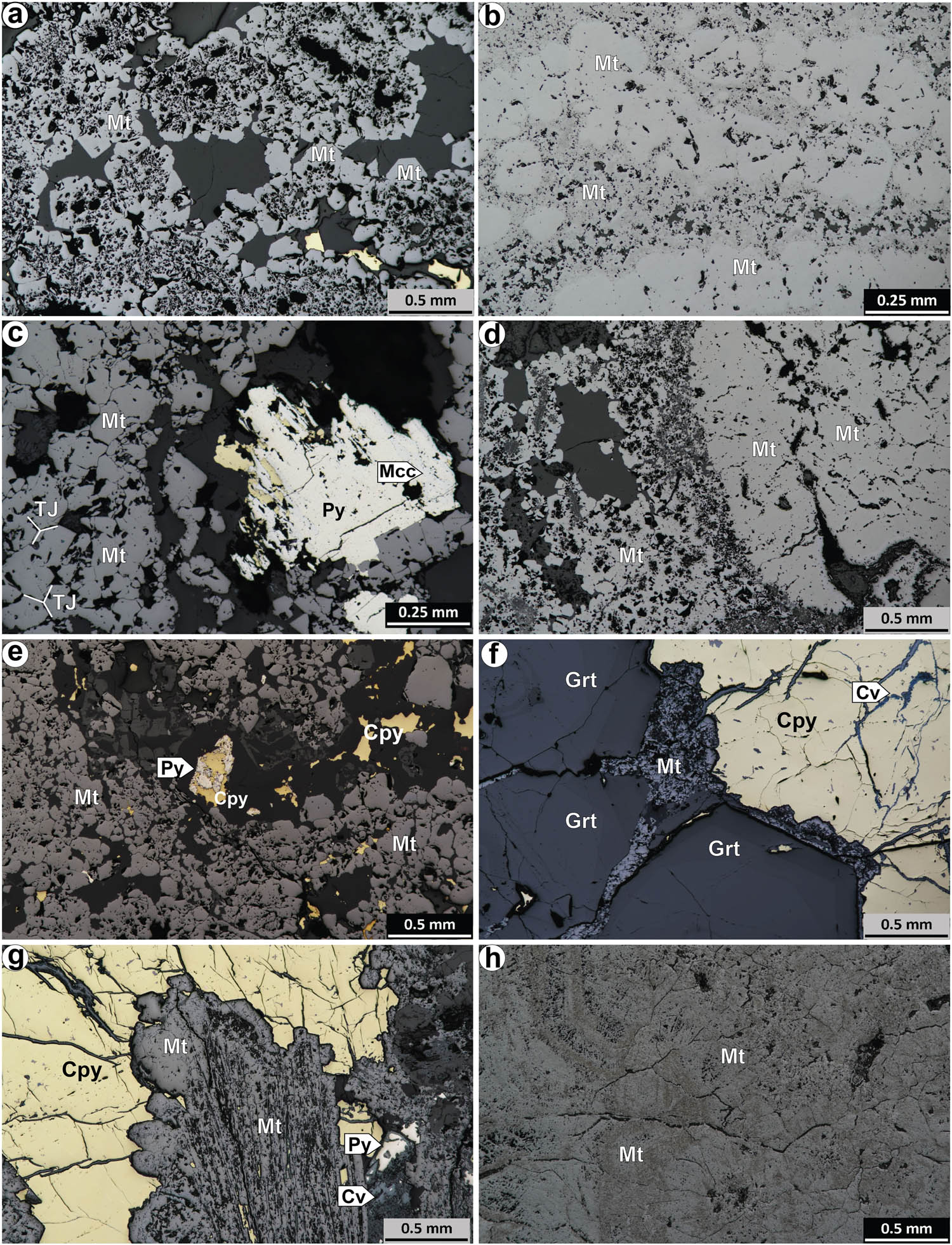
(a)–(d) Subhedral to euhedral grains of Khao Lek magnetite: (a), (c), and (d) Type-I massive magnetite (euhedral) and (b) and (d) Type-II anhedral massive magnetite. (c) Subhedral magnetite grains occur with anhedral pyrite and some marcasite and chalcopyrite. (e)–(h) The KTK magnetite was divided into two types: (1) massive Type-I, where (e) euhedral massive magnetite occurs after euhedral garnet, and (f) it is intergrown with chalcopyrite replaced by covellite along cracks (magnetite laths are also found in Type-I magnetite, (g); and Type-II, (h) where the KTK magnetite is completely replaced by garnet grains. Mt: magnetite, Py: pyrite, Mcc: marcasite, Cpy: chalcopyrite, Cv: covellite, TJ: triple junction (120°).
4.1.2 KTK
The Fe–Cu KTK deposits are mainly composed of magnetite, hematite, pyrite, and chalcopyrite, with minor covellite, calcite, and other silicate minerals, such as garnet, pyroxene, and quartz. Similarly, KTK magnetite can be divided into two types: euhedral massive magnetite (Type-I) (samples KTK1 and KTK3) and anhedral massive magnetite (Type-II) (sample KTK5). Type-I KTK euhedral/subhedral massive magnetite occurs after euhedral garnet (Figure 2e), and it is intergrown with chalcopyrite replaced by covellite along cracks (Figure 2f). Magnetite laths were also found in KTK Type-I magnetite (Figure 2g). The rims of abundant euhedral pyrite grains are replaced by magnetite (Figure 2g). The KTK Type-II magnetite is completely replaced by garnet grains (Figure 2h).
4.2 Trace elements
The LA-ICP-MS data from 53 analyses are listed in Table 1. All magnetite from the KL deposit contains a very high concentration of Si (up to 1.8 wt.%), Al (up to 0.5 wt.%), and Mn (>600 ppm). The euhedral massive magnetite (KL1) had the highest content of Ni (average = 38.39 ppm) and V (average = 6.27) (Figure 3d and b), and the lowest content of Al (average = 711 ppm), Y (average = 0.03 ppm), and Nb (average = 0.03 ppm) (Figure 3n–o). The trace element composition of the anhedral magnetite (KL6) is significantly enriched in Al (1,245–5,396 ppm), Sn (24.39–111.54 ppm), Y (0.76–6.79 ppm), Cu (3.42–8.55 ppm), and Zn (78.95–438.53 ppm) (Figure 3) and depleted in Ni (0.13–0.38 ppm) (Figure 3d). Anhedral magnetite (KL4) is characterized by lower Ga, Ti, and V compared with that in KL1 and KL6, with average concentrations of 2.33, 21, and 1.10 ppm, respectively (Table 1).
Analytical results (ppm) of the LA inductively coupled plasma mass spectrometry of magnetite from the KL and KTK deposits
| Sample | Form | ppm | Si | Ti | Al | Mn | Mg | Ca | Co | Cr | Cu | Ga | Ge | Nb | Ni | Pb | Sn | V | Y | Zn |
|---|---|---|---|---|---|---|---|---|---|---|---|---|---|---|---|---|---|---|---|---|
| KL1 (n = 11) | Euhedral | Av. | 3,082 | 69 | 711 | 687 | 151 | 322 | 39 | n.d. | 1.62 | 5.03 | 1.73 | 0.03 | 38.39 | 0.20 | 2.53 | 6.27 | 0.03 | 43.65 |
| Min | 2,241 | 54 | 285 | 587 | 72 | 79 | 37 | n.d. | 0.22 | 4.69 | 1.25 | 0.02 | 25.78 | 0.04 | 0.33 | 4.19 | 0.01 | 33.74 | ||
| Max | 3,980 | 75 | 938 | 735 | 197 | 895 | 43 | n.d. | 5.87 | 5.21 | 2.34 | 0.06 | 53.97 | 0.95 | 5.78 | 9.77 | 0.07 | 53.75 | ||
| KL4 (n = 5) | Anhedral | Av. | 12,303 | 21 | 1,477 | 1,323 | 320 | 1,275 | 58 | 1.04 | 0.21 | 2.33 | 1.08 | 0.07 | 1.89 | 0.79 | 1.62 | 1.10 | 0.36 | 25.14 |
| Min | 4,555 | 12 | 735 | 1,261 | 60 | 677 | 54 | 0.88 | 0.21 | 1.92 | 0.79 | 0.05 | 1.72 | 0.05 | 0.14 | 1.05 | 0.08 | 14.84 | ||
| Max | 17,918 | 33 | 2,094 | 13,79 | 675 | 2,137 | 66 | 1.36 | 0.21 | 2.71 | 1.48 | 0.10 | 2.34 | 1.86 | 2.85 | 1.18 | 0.82 | 47.10 | ||
| KL6 (n = 13) | Anhedral | Av. | 8,388 | 72 | 4,114 | 1,341 | 876 | 343 | 64 | 0.85 | 5.99 | 9.15 | 1.23 | 0.09 | 0.27 | 0.45 | 77.14 | 3.79 | 3.23 | 286.00 |
| Min | 2,478 | 13 | 1,245 | 696 | 104 | 68 | 33 | 0.69 | 3.42 | 8.21 | 1.01 | 0.07 | 0.13 | 0.05 | 24.39 | 0.76 | 0.38 | 78.95 | ||
| Max | 11,013 | 142 | 5,396 | 1,765 | 1,558 | 634 | 84 | 1.06 | 8.55 | 9.93 | 1.55 | 0.11 | 0.38 | 0.90 | 111.54 | 6.79 | 5.59 | 438.53 | ||
| KL6 (n = 5) | Euhedral | Av. | 17,358 | 81 | 640 | 389 | 467 | 922 | 55 | 1.23 | 1.04 | 9.08 | 1.36 | 0.01 | 1.28 | 0.67 | 8.66 | 9.02 | 0.37 | 17.77 |
| Min | 2,935 | 65 | 310 | 308 | 99 | 466 | 17 | 0.85 | 0.64 | 7.63 | 0.94 | 0.01 | 1.03 | 0.34 | 1.98 | 6.50 | 0.08 | 11.03 | ||
| Max | 64,621 | 117 | 1,083 | 452 | 1,307 | 1,567 | 198 | 1.60 | 1.45 | 11.05 | 2.16 | 0.01 | 1.72 | 0.93 | 24.67 | 11.47 | 0.91 | 23.61 | ||
| KTK1 (n = 4) | Euhedral | Av. | 3,763 | 76 | 782 | 703 | 264 | 1,890 | 50 | 0.74 | 40.78 | 4.99 | 2.22 | 0.02 | 54.45 | 0.69 | 0.69 | 7.66 | 0.12 | 120.08 |
| Min | 3,364 | 64 | 396 | 656 | 217 | 127 | 39 | 0.72 | 0.65 | 4.81 | 1.94 | 0.02 | 46.18 | 0.07 | 0.15 | 6.59 | 0.02 | 50.10 | ||
| Max | 4,044 | 96 | 1,158 | 748 | 334 | 6,554 | 77 | 0.76 | 98.30 | 5.36 | 2.53 | 0.03 | 61.57 | 2.07 | 1.07 | 8.64 | 0.31 | 266.89 | ||
| KTK3 (n = 10) | Euhedral | Av. | 21,332 | 103 | 4,088 | 615 | 1,535 | 1,672 | 50 | 5.45 | 4,775 | 3.55 | 3.45 | 0.16 | 500.00 | 31.85 | 1.87 | 42.06 | 1.15 | 1563.70 |
| Min | 8,019 | 37 | 1,567 | 478 | 464 | 555 | 29 | 0.53 | 455 | 2.54 | 1.71 | 0.05 | 173.37 | 2.04 | 0.24 | 9.38 | 0.14 | 253.96 | ||
| Max | 43,247 | 199 | 11,391 | 681 | 4,723 | 6,749 | 88 | 10.36 | 11,687 | 5.31 | 5.90 | 0.34 | 1194.69 | 108.39 | 8.16 | 82.73 | 3.89 | 3659.36 | ||
| KTK5 (n = 5) | Anhedral | Av. | 7,089 | 51 | 3,744 | 281 | 925 | 952 | 15 | 2.88 | 1,056 | 15.01 | 1.39 | 0.52 | 1.75 | 1.95 | 0.90 | 24.22 | 0.12 | 78.93 |
| Min | 6,606 | 27 | 2,842 | 8 | 52 | 668 | 3 | 1.86 | 624 | 14.77 | 0.84 | 0.33 | 1.00 | 1.24 | 0.48 | 17.82 | 0.03 | 1.44 | ||
| Max | 7,871 | 79 | 4,350 | 912 | 3,293 | 1,812 | 36 | 4.36 | 1,382 | 15.23 | 3.44 | 0.78 | 3.31 | 2.55 | 1.16 | 29.61 | 0.44 | 209.31 |
n.d.: not detected.

Box and whisker plots of important minor and trace elements (ppm) in the magnetite grouped by deposit site. The data are plotted on a logarithmic scale in order of increasing median concentrations. The upper and lower margins of the boxes represent the upper and lower 50th percentiles, respectively, of the data. The whiskers represent the upper and lower threshold values (the 95th percentiles of the data). Median values are shown as solid black lines, and mean values are shown as solid black circles.
Compared to the other KTK samples, the magnetite in sample KTK3 contains the highest contents of Si (average = 2 wt.%), Al (average = 0.4 wt.%), Cu (average = 4,775 ppm), Zn (average = 1,564 ppm), Ni (average = 500 ppm), Pb (average = 32 ppm), and V (average = 42 ppm) (Figure 3). Trace element concentrations in KTK1 were similar to those in KL1 from the KL deposit. KTK1 contains high concentrations of Mn (average = 615 ppm) and Ca (average = 1,890 ppm), and KTK5 (anhedral magnetite) contains the highest Nb content (average = 0.378 ppm) (Table 1).
Binary plots of some of the analyzed trace elements in the KL and KTK magnetites indicated that Mg is positively correlated with Si, Al, Mn, and Co (Figure 4). Mg and V plots were used to distinguish the skarn deposit types (Figure 4). Magnetite in the KTK deposit contains high concentrations of V and Mg, especially KTK3 and KTK5. In the case of Mn, KL6 (anhedral magnetite), and KL4 are significantly different from the other samples.
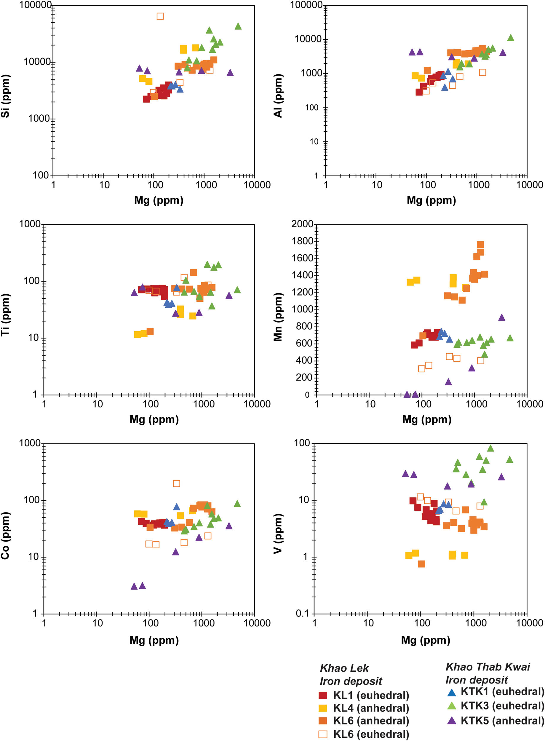
Binary plots of Mg versus other trace elements.
Mapping was used to determine the elemental distribution of Type-I magnetite (KL1) (Figure 5). The results verified by the EPMA analysis suggested that some mobile elements, such as Si, Al, and Mg, decrease from the core to the rim. Moreover, there are referred to the dark gray zones are characterized by higher Si, Al, and Mg contents than in light gray zones (Figure 3c). The euhedral magnetite exhibited characteristic oscillatory Si (Figure 5b) and Mg (Figure 5d) zoning that represents the fluctuation hydrothermal fluid.

(a)–(l) Mapping of magnetite grains in Type-I euhedral magnetite. (d) Mg zoning related to Si and Ca concentrations.
5 Discussion
5.1 Trace element behavior and genesis of magnetite
Geochemical studies are used to classify magnetite deposit types based on major and trace element compositions, and magnetite can be used to study mineral precipitation. Much previous research has suggested that magnetite can be derived from either hydrothermal or magmatic fluids [11,16,17,21,22]. In this study, based on mineral assemblages, magnetite in the KL and KTK deposits was commonly coprecipitated with retrograde minerals (e.g., biotite, tremolite, hornblende, and quartz) and sulfide minerals (e.g., pyrite and chalcopyrite), suggesting a hydrothermal source [21,22].
Moreover, Dare et al. [16] and Nadoll et al. [23] suggested that hydrothermal and magmatic origins produce different magnetite compositions, expressed as the specific ranges of individual elements. Ti and V are key elements for such discrimination, with high Ti and V contents indicating magmatic magnetite, and their depletion suggesting hydrothermal magnetite [16,17,23]. Although the euhedral magnetite in KL1 had higher concentrations of Ti and V compared to the anhedral magnetite, the Ti–V diagram modified from Nadoll et al. [23] and Knipping et al. [11] indicates that the magnetite from KL and KTK is hydrothermal magnetite (Figure 6a). In addition, the Ni/Cr ratio of almost all the magnetite is typically >0.1; therefore, the Ti versus Ni/Cr diagram [16,21] also indicates that the origin of the magnetite was a hydrothermal environment (Figure 6b). Cr is an important element commonly incorporated into magnetite, especially in ultramafic and mafic host rocks [9,16,24]; however, in this study, the magnetite contained very low concentrations of Cr (or lower than the detection limit), indicating hydrothermal skarn deposition, which was supported by Nadoll et al. [23]. This indicates that both the KL and KTK magnetite are associated with hydrothermal skarns (Figure 6c) [23]. In addition, the magnetite plots in the skarn field of the Ti + V versus Ca + Al + Mn discrimination diagram [9] (Figure 6d). The magnetite from both the KL and KTK Fe deposits contains high levels of Mn and Mg, which also indicates a skarn system [17]. The Mn content in the euhedral and anhedral massive magnetite ranged from 308 to 748 ppm and from 8 to 1,765 ppm, respectively, and the Mg content of the euhedral and anhedral massive magnetite ranged from 72 to 4,723 ppm and 60 to 3,293 ppm, respectively.
![Figure 6
Magnetite discrimination diagrams. (a) Plot of Ti versus V concentrations [11]. Based on Nadoll et al.’s data set [17], the red field is igneous (magmatic) magnetite, and the green field is hydrothermal magnetite. (b) Ti versus Ni/Cr [16]. (c) Ti + V versus Ni/(Cr + Mn) discrimination diagram [9]. (d) Magnetite Ti + V versus Ca + Al + Mn discrimination diagram [9].](/document/doi/10.1515/geo-2022-0638/asset/graphic/j_geo-2022-0638_fig_006.jpg)
Magnetite discrimination diagrams. (a) Plot of Ti versus V concentrations [11]. Based on Nadoll et al.’s data set [17], the red field is igneous (magmatic) magnetite, and the green field is hydrothermal magnetite. (b) Ti versus Ni/Cr [16]. (c) Ti + V versus Ni/(Cr + Mn) discrimination diagram [9]. (d) Magnetite Ti + V versus Ca + Al + Mn discrimination diagram [9].
Furthermore, two models for the origin of magnetite triple boundary junctions, as observed in the subhedral to euhedral magnetite grains from the KL deposit (Figure 2c), have been suggested: (1) high-temperature annealing in a closed system (i.e., magmatic magnetite) [25] and (2) fluid-assisted recrystallization/replacement in an open system (i.e., quartz) [26,27]. In this study, the calcite observed filling open spaces within crack-seal textures in equilibrium with the precipitation of the euhedral magnetite was probably derived from fluid-assisted recrystallization/replacement in an open system. In addition, the low Ti content (12–199 ppm; Table 1) observed in both types of magnetite in this study also indicates a nonmagmatic origin [16].
5.2 Multi-element variation diagrams
The data for the trace element composition of the magnetite were summarized using multi-element variation diagrams. The elements were normalized using the bulk continental crust data presented by Rudnick et al. [28] because the interaction of hydrothermal fluids with crustal rocks is likelier than the interaction with primitive mantle [16]. Thus, the multi-element variation diagram for magnetite trace elements can be applied to genetic and provenance studies of ore deposits [9,16,17]. Magnetite from both deposits exhibited patterns similar to those of magnetite observed in calcic Fe-skarn deposits from Vegas Peledas, Argentina [29] and the Beiya skarn deposit [22] (Figure 8). As discussed in Section 5.1, most of the hydrothermal magnetite from the KL and KTK Fe deposits plots in the skarn fields of the discrimination diagrams developed by Dupuis and Beaudoin [9] and Nadoll et al. [23] (Figure 6c and d), which implies that the origin of the skarn magnetite deposits is hydrothermal.
![Figure 7
Ti + V versus Al + Mn diagram of temperature ranges [9,16].](/document/doi/10.1515/geo-2022-0638/asset/graphic/j_geo-2022-0638_fig_007.jpg)
5.3 Oxygen fugacity and temperature of magnetite mineralization
Vanadium exhibits various oxidation states (e.g., V3+, V4+, and V5+) in magnetite resulting from oxygen fugacity (f O2) [17]. With increasing f O2, V3+ converts to V4+, which results in a reduction in the concentration of V in magnetite [16]. Furthermore, at high f O2, V5+ is incompatible Therefore, V content is significant for determining f O2 [17].
The magnetite in the KL deposit contains lower concentrations of V (1.05–11.47 ppm) than the magnetite in the KTK deposit (6.59–82.73 ppm) (Table 1). Therefore, the f O2 of the KTK deposit may have been lower compared to the KL deposit. In the KL deposit, the euhedral magnetite, including that in KL1 (4.19–9.77 ppm) and KL6 (6.50–11.47 ppm), contains significantly higher concentrations of V than the anhedral massive magnetite (KL4 1.05–1.18 ppm and KL6 0.76–6.79 ppm). Therefore, the euhedral massive magnetite may have been formed in more reducing conditions than the anhedral massive magnetite. In the KTK deposit, the V content of the magnetite varied according to the textural features of the magnetite. Euhedral magnetite in KTK1 has the lowest V concentration (6.59–8.64 ppm) compared to euhedral magnetite in KTK3 (9.38–82.73 ppm) and anhedral massive magnetite in KTK5 (17.82–29.61 ppm). The V content of the euhedral massive magnetite in KTK3 is the highest of all the samples, which suggests that the KTK3 magnetite was formed in the highest reducing condition.
The temperature dependence of Ti, V, Al, Mn, and Ga can distinguish between low- and high-temperature mineral systems [17]. A Ti + V versus Al + Mn discrimination diagram [30] shows that all the magnetite precipitation temperatures ranged between 200 and 300°C (Figure 7). In the KL deposit, plot of euhedral magnetite (KL1 and KL6 euhedral) is separated from anhedral massive magnetite (KL4 and KL6 anhedral) (see Figure 7). According to the Ti + V versus Al + Mn diagram [30], magnetite containing low concentrations of these elements implies relatively lower temperatures. Therefore, the euhedral magnetite from the KL deposit was precipitated at relatively low temperatures compared to the anhedral massive magnetite, and most of the magnetite from the KTK deposit was deposited at higher temperatures compared to the KL deposit. However, no relationship was observed between the textural features (e.g., euhedral and anhedral textures) and the formation temperatures of the magnetite in these deposits (Figure 7).
![Figure 8
Multi-element variation diagrams for the (a) Khao Lek and (b) KTK deposits normalized to upper continental crust (values from Rudnick et al. [28]). The light blue shading represents Beiya skarn magnetite [22], and the light pink shading represents magnetite in calcic Fe-skarns from Vegas Peledas, Argentina [29].](/document/doi/10.1515/geo-2022-0638/asset/graphic/j_geo-2022-0638_fig_008.jpg)
Multi-element variation diagrams for the (a) Khao Lek and (b) KTK deposits normalized to upper continental crust (values from Rudnick et al. [28]). The light blue shading represents Beiya skarn magnetite [22], and the light pink shading represents magnetite in calcic Fe-skarns from Vegas Peledas, Argentina [29].
6 Conclusion
The petrographic and chemical characteristics of euhedral and anhedral massive magnetite from the KL and KTK Fe-skarn deposits suggest that they have hydrothermal origins. The LA-ICP-MS determination of the magnetite trace elements demonstrated that magnetite is a sensitive indicator of mineralization in skarn deposits. All the magnetite types are mostly consistent with low-temperature hydrothermal magnetite. Both the KL and KTK deposits are classified by their chemical characteristics as skarn/calcic skarn deposits, characterized by higher Al and Mn and lower Ti, with V being a signature of a skarn deposit. In the KL Fe deposit, the composition of the fluids and host rocks controlled the concentration of Mn and Mg, and the temperature in this deposit ranged from 200 to 300°C.
Acknowledgments
This research project was supported by grants for the development of new faculty staff from the Ratchadaphiseksomphot Fund, Chulalongkorn University. The first author gratefully acknowledges financial support from the ASEA-UNINET One-Month Research Scholarship, Austria. Moreover, we would like to thank Dr. Dominik Sorger for the EPMA data analysis and Mr. Phakorn Intassingha for their help with the preparation of some of the diagrams in the manuscript.
-
Funding information: This study supported by the development of new faculty staff from the Ratchadaphiseksomphot Fund, Chulalongkorn University and the ASEA-UNINET One-Month Research Scholarship, Austria.
-
Author contributions: TA designed conceptualization, designed experiments, and prepared the main manuscript. KH collected and invested the sample. SK wrote and edited the manuscript. CS reviewed the manuscript. CH prepared a laboratory investigation and reviewed the manuscript. PK prepared the manuscript.
-
Conflict of interest: This study was conducted in the absence of any commercial or financial relationships that could be construed as a potential conflict of interest.
-
Data availability statement: The data that support the findings of this study are available from the corresponding author upon a reasonable request.
References
[1] Iron and steel institute of Thailand. Thailand steel outlook (in Thai). Bangkok: Iron and steel institute of Thailand; 2023.Search in Google Scholar
[2] Meinert LD. Skarns and skarn deposits. Canada: Geoscience; 1992.Search in Google Scholar
[3] Mokhtari MAA. The mineralogy and petrology of the Pahnavar Fe skarn, In the Eastern Azarbaijan, NW Iran. Cent Eur J Geosci. 2012;4(4):578–91. 10.2478/s13533-012-0106-y.Search in Google Scholar
[4] Brown GF. Geologic reconnaissance of the mineral deposits of Thailand. US: Government Printing Office; 1951.Search in Google Scholar
[5] Andrianarimanana M, Salam A, Sutthirat C, Manaka T. Mineralogy and petrography of skarn in khao lek area, Nong Bua District, Nakhon Sawan Province, Northern Thailand. Bull Earth Sci Thai. 2017;9(1):61–7.Search in Google Scholar
[6] Department of Primary Industries and Mines. Mineral and iron mining projects and other minerals to support the upstream steel industry of Thailand (fiscal year 2007). Bangkok: 2008.Search in Google Scholar
[7] Jongjaingarm T. Characteristics of Khao Lek skarn deposit, Amphoe Nong Bao, changwat Nakhon Sawan. BSc thesis. Thailand: Chulalongkorn University; 2016.Search in Google Scholar
[8] Department of Mineral Resources. Division of Materials Research. Exploration of basic geology and geological resource, Lopburi Province (in Thai). Bangkok: Department of Mineral Resources; 2023.Search in Google Scholar
[9] Dupuis C, Beaudoin G. Discriminant diagrams for iron oxide trace element fingerprinting of mineral deposit types. Miner Deposita. 2011;46(4):319–35. 10.1007/s00126-011-0334-y.Search in Google Scholar
[10] Williams PJ, Barton MD, Johnson DA, Fontboté L. Iron oxide copper–gold deposits: geology, space–time distribution, and possible modes of origin. Econ Geol Bull Soc Econ Geol 100th Anniv. 2005;371–405.10.5382/AV100.13Search in Google Scholar
[11] Knipping JL, Bilenker LD, Simon AC, Reich M, Barra F, Deditius AP, et al. Trace elements in magnetite from massive iron oxide-apatite deposits indicate a combined formation by igneous and magmatic-hydrothermal processes. Geochim Cosmochim Acta. 2015;171:15–38. 10.1016/j.gca.2015.08.010.Search in Google Scholar
[12] Liu YN, Fan Y, Zhou TF, White NC, Hong HL, Zhang W, et al. Insitu LA-ICP-MS trace element analysis of magnetite from Mesozoic iron oxide apatite (IOA) deposits in the Luzong volcanic basin, eastern China. J Asian Earth Sci. 2018;166:233–46. 10.1016/j.jseaes.2018.07.007.Search in Google Scholar
[13] Huang XW, Beaudoin G. Textures and chemical compositions of magnetite from iron oxide-copper-gold (IOCG) and Kiruna-type iron oxide-apatite (IOA) deposits and their implications for ore genesis and magnetite classification schemes. Econ Geol. 2019;114(5):953–79. 10.5382/econgeo.4651.Search in Google Scholar
[14] Huang XW, Sappin AA, Boutroy E, Beaudoin G, Makvandi S. Trace element composition of igneous and hydrothermal magnetite from porphyry deposits, Relationship to deposit subtypes and magmatic affinity. Econ Geol. 2019;114(5):917–52. 10.5382/econgeo.4648.Search in Google Scholar
[15] Hu X, Chen HY, Beaudoin G, Zhang Y. Textural and compositional evolution of iron oxides at Mina Justa (Peru), implications for mushketovite and formation of IOCG deposits. Am Mineral. 2020;105:397–408. 10.2138/am-2020-7024.Search in Google Scholar
[16] Dare SAS, Barnes S-J, Beaudoin G, Méric J, Boutroy E, Potvin-Doucet C. Trace elements in magnetite as petrogenetic indicators. Miner Deposita. 2014;49(7):785–96. 10.1007/s00126-014-0529-0.Search in Google Scholar
[17] Nadoll P, Angerer T, Mauk JL, French D, Walshe J. The chemistry of hydrothermal magnetite: a review. Ore Geol Rev. 2014;61:1–32. 10.1016/j.oregeorev.2013.12.013.Search in Google Scholar
[18] Intayot S. Genesis of skarn in Khao Phra Ngam area Chagwat Lop Buri. PhD thesis, Graduate School. Thailand: Chiang Mai University; 2006.Search in Google Scholar
[19] Songserm N. Petrography of iron skarn at Khao Lek, Amphoe Nong Bua, Changwat Nakorn Sawan. BSc thesis. Thailand: Chulalongkorn University; 2016.Search in Google Scholar
[20] Ratchawongsa P. Petrography of iron skarn at Khao Lek, Amphoe Nong Bua, Changwat Nakhon Sawan. BSc thesis. Thailand: Chulalongkorn University; 2009.Search in Google Scholar
[21] Li D-F, Chen H-Y, Hollings P, Zhang L, Sun X-M, Zheng Y, et al. Trace element geochemistry of magnetite: implications for ore genesis of the Talate skarn Pb-Zn (-Fe) deposit, Altay, NW China. Ore Geol Rev. 2018;100:471–82. 10.1016/j.oregeorev.2017.03.015.Search in Google Scholar
[22] Sun X, Lin H, Fu Y, Li D, Hollings P, Yang T, et al. Trace element geochemistry of magnetite from the giant Beiya gold-polymetallic deposit in Yunnan Province, Southwest China and its implications for the ore forming processes. Ore Geol Rev. 2017;91:477–90. 10.1016/j.oregeorev.2017.09.007.Search in Google Scholar
[23] Nadoll P, Mauk JL, Leveille RA, Koenig AE. Geochemistry of magnetite from porphyry Cu and skarn deposits in the southwestern United States. Mineral Deposita. 2015;50(4):493–515. 10.1007/s00126-014-0539-y.Search in Google Scholar
[24] Frost BR, Lindsley DH. Chapter 12. Occurrence of iron-titanium oxides in igneous rocks. In: Donald HL, editor. Oxide Minerals. Berlin: De Gruyter; 1991. p. 433–68.10.1515/9781501508684-015Search in Google Scholar
[25] Ciobanu CL, Cook NJ. Skarn textures and a case study: the Ocna de Fier-Dognecea orefield, Banat, Romania. Ore Geol Rev. 2004;24(3–4):315–70. 10.1016/j.oregeorev.2003.04.002.Search in Google Scholar
[26] Nakamura M, Watson EB. Experimental study of aqueous fluid infiltration into quartzite: implications for the kinetics of fluid redistribution and grain growth driven by interfacial energy reduction. Geofluids. 2001;1(2):73–89. 10.1046/j.1468-8123.2001.00007.x.Search in Google Scholar
[27] Hu H, Lentz D, Li J-W, McCarron T, Zhao X-F, Hall D. Reequilibration processes in magnetite from iron skarn deposits. Econ Geol. 2015;110(1):1–8. 10.2113/econgeo.110.1.1.Search in Google Scholar
[28] Rudnick R, Gao S, Holland H, Turekian K. Composition of the continental crust. The Crust. 2003;3:1–64.10.1016/B0-08-043751-6/03016-4Search in Google Scholar
[29] Pons JM, Franchini M, Meinert L, Recio C, Etcheverry R. Iron skarns of the Vegas Peladas District, Mendoza, Argentina. Econ Geol. 2009;104(2):157–84. 10.2113/gsecongeo.104.2.157.Search in Google Scholar
[30] Deditius AP, Reich M, Simon AC, Suvorova A, Knipping J, Roberts MP, et al. Nanogeochemistry of hydrothermal magnetite. Contrib Mineral Petrol. 2018;173(46):1–20. 10.1007/s00410-018-1474-1.Search in Google Scholar
© 2024 the author(s), published by De Gruyter
This work is licensed under the Creative Commons Attribution 4.0 International License.
Articles in the same Issue
- Regular Articles
- Theoretical magnetotelluric response of stratiform earth consisting of alternative homogeneous and transitional layers
- The research of common drought indexes for the application to the drought monitoring in the region of Jin Sha river
- Evolutionary game analysis of government, businesses, and consumers in high-standard farmland low-carbon construction
- On the use of low-frequency passive seismic as a direct hydrocarbon indicator: A case study at Banyubang oil field, Indonesia
- Water transportation planning in connection with extreme weather conditions; case study – Port of Novi Sad, Serbia
- Zircon U–Pb ages of the Paleozoic volcaniclastic strata in the Junggar Basin, NW China
- Monitoring of mangrove forests vegetation based on optical versus microwave data: A case study western coast of Saudi Arabia
- Microfacies analysis of marine shale: A case study of the shales of the Wufeng–Longmaxi formation in the western Chongqing, Sichuan Basin, China
- Multisource remote sensing image fusion processing in plateau seismic region feature information extraction and application analysis – An example of the Menyuan Ms6.9 earthquake on January 8, 2022
- Identification of magnetic mineralogy and paleo-flow direction of the Miocene-quaternary volcanic products in the north of Lake Van, Eastern Turkey
- Impact of fully rotating steel casing bored pile on adjacent tunnels
- Adolescents’ consumption intentions toward leisure tourism in high-risk leisure environments in riverine areas
- Petrogenesis of Jurassic granitic rocks in South China Block: Implications for events related to subduction of Paleo-Pacific plate
- Differences in urban daytime and night block vitality based on mobile phone signaling data: A case study of Kunming’s urban district
- Random forest and artificial neural network-based tsunami forests classification using data fusion of Sentinel-2 and Airbus Vision-1 satellites: A case study of Garhi Chandan, Pakistan
- Integrated geophysical approach for detection and size-geometry characterization of a multiscale karst system in carbonate units, semiarid Brazil
- Spatial and temporal changes in ecosystem services value and analysis of driving factors in the Yangtze River Delta Region
- Deep fault sliding rates for Ka-Ping block of Xinjiang based on repeating earthquakes
- Improved deep learning segmentation of outdoor point clouds with different sampling strategies and using intensities
- Platform margin belt structure and sedimentation characteristics of Changxing Formation reefs on both sides of the Kaijiang-Liangping trough, eastern Sichuan Basin, China
- Enhancing attapulgite and cement-modified loess for effective landfill lining: A study on seepage prevention and Cu/Pb ion adsorption
- Flood risk assessment, a case study in an arid environment of Southeast Morocco
- Lower limits of physical properties and classification evaluation criteria of the tight reservoir in the Ahe Formation in the Dibei Area of the Kuqa depression
- Evaluation of Viaducts’ contribution to road network accessibility in the Yunnan–Guizhou area based on the node deletion method
- Permian tectonic switch of the southern Central Asian Orogenic Belt: Constraints from magmatism in the southern Alxa region, NW China
- Element geochemical differences in lower Cambrian black shales with hydrothermal sedimentation in the Yangtze block, South China
- Three-dimensional finite-memory quasi-Newton inversion of the magnetotelluric based on unstructured grids
- Obliquity-paced summer monsoon from the Shilou red clay section on the eastern Chinese Loess Plateau
- Classification and logging identification of reservoir space near the upper Ordovician pinch-out line in Tahe Oilfield
- Ultra-deep channel sand body target recognition method based on improved deep learning under UAV cluster
- New formula to determine flyrock distance on sedimentary rocks with low strength
- Assessing the ecological security of tourism in Northeast China
- Effective reservoir identification and sweet spot prediction in Chang 8 Member tight oil reservoirs in Huanjiang area, Ordos Basin
- Detecting heterogeneity of spatial accessibility to sports facilities for adolescents at fine scale: A case study in Changsha, China
- Effects of freeze–thaw cycles on soil nutrients by soft rock and sand remodeling
- Vibration prediction with a method based on the absorption property of blast-induced seismic waves: A case study
- A new look at the geodynamic development of the Ediacaran–early Cambrian forearc basalts of the Tannuola-Khamsara Island Arc (Central Asia, Russia): Conclusions from geological, geochemical, and Nd-isotope data
- Spatio-temporal analysis of the driving factors of urban land use expansion in China: A study of the Yangtze River Delta region
- Selection of Euler deconvolution solutions using the enhanced horizontal gradient and stable vertical differentiation
- Phase change of the Ordovician hydrocarbon in the Tarim Basin: A case study from the Halahatang–Shunbei area
- Using interpretative structure model and analytical network process for optimum site selection of airport locations in Delta Egypt
- Geochemistry of magnetite from Fe-skarn deposits along the central Loei Fold Belt, Thailand
- Functional typology of settlements in the Srem region, Serbia
- Hunger Games Search for the elucidation of gravity anomalies with application to geothermal energy investigations and volcanic activity studies
- Addressing incomplete tile phenomena in image tiling: Introducing the grid six-intersection model
- Evaluation and control model for resilience of water resource building system based on fuzzy comprehensive evaluation method and its application
- MIF and AHP methods for delineation of groundwater potential zones using remote sensing and GIS techniques in Tirunelveli, Tenkasi District, India
- New database for the estimation of dynamic coefficient of friction of snow
- Measuring urban growth dynamics: A study in Hue city, Vietnam
- Comparative models of support-vector machine, multilayer perceptron, and decision tree predication approaches for landslide susceptibility analysis
- Experimental study on the influence of clay content on the shear strength of silty soil and mechanism analysis
- Geosite assessment as a contribution to the sustainable development of Babušnica, Serbia
- Using fuzzy analytical hierarchy process for road transportation services management based on remote sensing and GIS technology
- Accumulation mechanism of multi-type unconventional oil and gas reservoirs in Northern China: Taking Hari Sag of the Yin’e Basin as an example
- TOC prediction of source rocks based on the convolutional neural network and logging curves – A case study of Pinghu Formation in Xihu Sag
- A method for fast detection of wind farms from remote sensing images using deep learning and geospatial analysis
- Spatial distribution and driving factors of karst rocky desertification in Southwest China based on GIS and geodetector
- Physicochemical and mineralogical composition studies of clays from Share and Tshonga areas, Northern Bida Basin, Nigeria: Implications for Geophagia
- Geochemical sedimentary records of eutrophication and environmental change in Chaohu Lake, East China
- Research progress of freeze–thaw rock using bibliometric analysis
- Mixed irrigation affects the composition and diversity of the soil bacterial community
- Examining the swelling potential of cohesive soils with high plasticity according to their index properties using GIS
- Geological genesis and identification of high-porosity and low-permeability sandstones in the Cretaceous Bashkirchik Formation, northern Tarim Basin
- Usability of PPGIS tools exemplified by geodiscussion – a tool for public participation in shaping public space
- Efficient development technology of Upper Paleozoic Lower Shihezi tight sandstone gas reservoir in northeastern Ordos Basin
- Assessment of soil resources of agricultural landscapes in Turkestan region of the Republic of Kazakhstan based on agrochemical indexes
- Evaluating the impact of DEM interpolation algorithms on relief index for soil resource management
- Petrogenetic relationship between plutonic and subvolcanic rocks in the Jurassic Shuikoushan complex, South China
- A novel workflow for shale lithology identification – A case study in the Gulong Depression, Songliao Basin, China
- Characteristics and main controlling factors of dolomite reservoirs in Fei-3 Member of Feixianguan Formation of Lower Triassic, Puguang area
- Impact of high-speed railway network on county-level accessibility and economic linkage in Jiangxi Province, China: A spatio-temporal data analysis
- Estimation model of wild fractional vegetation cover based on RGB vegetation index and its application
- Lithofacies, petrography, and geochemistry of the Lamphun oceanic plate stratigraphy: As a record of the subduction history of Paleo-Tethys in Chiang Mai-Chiang Rai Suture Zone of Thailand
- Structural features and tectonic activity of the Weihe Fault, central China
- Application of the wavelet transform and Hilbert–Huang transform in stratigraphic sequence division of Jurassic Shaximiao Formation in Southwest Sichuan Basin
- Structural detachment influences the shale gas preservation in the Wufeng-Longmaxi Formation, Northern Guizhou Province
- Distribution law of Chang 7 Member tight oil in the western Ordos Basin based on geological, logging and numerical simulation techniques
- Evaluation of alteration in the geothermal province west of Cappadocia, Türkiye: Mineralogical, petrographical, geochemical, and remote sensing data
- Numerical modeling of site response at large strains with simplified nonlinear models: Application to Lotung seismic array
- Quantitative characterization of granite failure intensity under dynamic disturbance from energy standpoint
- Characteristics of debris flow dynamics and prediction of the hazardous area in Bangou Village, Yanqing District, Beijing, China
- Rockfall mapping and susceptibility evaluation based on UAV high-resolution imagery and support vector machine method
- Statistical comparison analysis of different real-time kinematic methods for the development of photogrammetric products: CORS-RTK, CORS-RTK + PPK, RTK-DRTK2, and RTK + DRTK2 + GCP
- Hydrogeological mapping of fracture networks using earth observation data to improve rainfall–runoff modeling in arid mountains, Saudi Arabia
- Petrography and geochemistry of pegmatite and leucogranite of Ntega-Marangara area, Burundi, in relation to rare metal mineralisation
- Prediction of formation fracture pressure based on reinforcement learning and XGBoost
- Hazard zonation for potential earthquake-induced landslide in the eastern East Kunlun fault zone
- Monitoring water infiltration in multiple layers of sandstone coal mining model with cracks using ERT
- Study of the patterns of ice lake variation and the factors influencing these changes in the western Nyingchi area
- Productive conservation at the landslide prone area under the threat of rapid land cover changes
- Sedimentary processes and patterns in deposits corresponding to freshwater lake-facies of hyperpycnal flow – An experimental study based on flume depositional simulations
- Study on time-dependent injectability evaluation of mudstone considering the self-healing effect
- Detection of objects with diverse geometric shapes in GPR images using deep-learning methods
- Behavior of trace metals in sedimentary cores from marine and lacustrine environments in Algeria
- Spatiotemporal variation pattern and spatial coupling relationship between NDVI and LST in Mu Us Sandy Land
- Formation mechanism and oil-bearing properties of gravity flow sand body of Chang 63 sub-member of Yanchang Formation in Huaqing area, Ordos Basin
- Diagenesis of marine-continental transitional shale from the Upper Permian Longtan Formation in southern Sichuan Basin, China
- Vertical high-velocity structures and seismic activity in western Shandong Rise, China: Case study inspired by double-difference seismic tomography
- Spatial coupling relationship between metamorphic core complex and gold deposits: Constraints from geophysical electromagnetics
- Disparities in the geospatial allocation of public facilities from the perspective of living circles
- Research on spatial correlation structure of war heritage based on field theory. A case study of Jinzhai County, China
- Formation mechanisms of Qiaoba-Zhongdu Danxia landforms in southwestern Sichuan Province, China
- Magnetic data interpretation: Implication for structure and hydrocarbon potentiality at Delta Wadi Diit, Southeastern Egypt
- Deeply buried clastic rock diagenesis evolution mechanism of Dongdaohaizi sag in the center of Junggar fault basin, Northwest China
- Application of LS-RAPID to simulate the motion of two contrasting landslides triggered by earthquakes
- The new insight of tectonic setting in Sunda–Banda transition zone using tomography seismic. Case study: 7.1 M deep earthquake 29 August 2023
- The critical role of c and φ in ensuring stability: A study on rockfill dams
- Evidence of late quaternary activity of the Weining-Shuicheng Fault in Guizhou, China
- Extreme hydroclimatic events and response of vegetation in the eastern QTP since 10 ka
- Spatial–temporal effect of sea–land gradient on landscape pattern and ecological risk in the coastal zone: A case study of Dalian City
- Study on the influence mechanism of land use on carbon storage under multiple scenarios: A case study of Wenzhou
- A new method for identifying reservoir fluid properties based on well logging data: A case study from PL block of Bohai Bay Basin, North China
- Comparison between thermal models across the Middle Magdalena Valley, Eastern Cordillera, and Eastern Llanos basins in Colombia
- Mineralogical and elemental analysis of Kazakh coals from three mines: Preliminary insights from mode of occurrence to environmental impacts
- Chlorite-induced porosity evolution in multi-source tight sandstone reservoirs: A case study of the Shaximiao Formation in western Sichuan Basin
- Predicting stability factors for rotational failures in earth slopes and embankments using artificial intelligence techniques
- Origin of Late Cretaceous A-type granitoids in South China: Response to the rollback and retreat of the Paleo-Pacific plate
- Modification of dolomitization on reservoir spaces in reef–shoal complex: A case study of Permian Changxing Formation, Sichuan Basin, SW China
- Geological characteristics of the Daduhe gold belt, western Sichuan, China: Implications for exploration
- Rock physics model for deep coal-bed methane reservoir based on equivalent medium theory: A case study of Carboniferous-Permian in Eastern Ordos Basin
- Enhancing the total-field magnetic anomaly using the normalized source strength
- Shear wave velocity profiling of Riyadh City, Saudi Arabia, utilizing the multi-channel analysis of surface waves method
- Effect of coal facies on pore structure heterogeneity of coal measures: Quantitative characterization and comparative study
- Inversion method of organic matter content of different types of soils in black soil area based on hyperspectral indices
- Detection of seepage zones in artificial levees: A case study at the Körös River, Hungary
- Tight sandstone fluid detection technology based on multi-wave seismic data
- Characteristics and control techniques of soft rock tunnel lining cracks in high geo-stress environments: Case study of Wushaoling tunnel group
- Influence of pore structure characteristics on the Permian Shan-1 reservoir in Longdong, Southwest Ordos Basin, China
- Study on sedimentary model of Shanxi Formation – Lower Shihezi Formation in Da 17 well area of Daniudi gas field, Ordos Basin
- Multi-scenario territorial spatial simulation and dynamic changes: A case study of Jilin Province in China from 1985 to 2030
- Review Articles
- Major ascidian species with negative impacts on bivalve aquaculture: Current knowledge and future research aims
- Prediction and assessment of meteorological drought in southwest China using long short-term memory model
- Communication
- Essential questions in earth and geosciences according to large language models
- Erratum
- Erratum to “Random forest and artificial neural network-based tsunami forests classification using data fusion of Sentinel-2 and Airbus Vision-1 satellites: A case study of Garhi Chandan, Pakistan”
- Special Issue: Natural Resources and Environmental Risks: Towards a Sustainable Future - Part I
- Spatial-temporal and trend analysis of traffic accidents in AP Vojvodina (North Serbia)
- Exploring environmental awareness, knowledge, and safety: A comparative study among students in Montenegro and North Macedonia
- Determinants influencing tourists’ willingness to visit Türkiye – Impact of earthquake hazards on Serbian visitors’ preferences
- Application of remote sensing in monitoring land degradation: A case study of Stanari municipality (Bosnia and Herzegovina)
- Optimizing agricultural land use: A GIS-based assessment of suitability in the Sana River Basin, Bosnia and Herzegovina
- Assessing risk-prone areas in the Kratovska Reka catchment (North Macedonia) by integrating advanced geospatial analytics and flash flood potential index
- Analysis of the intensity of erosive processes and state of vegetation cover in the zone of influence of the Kolubara Mining Basin
- GIS-based spatial modeling of landslide susceptibility using BWM-LSI: A case study – city of Smederevo (Serbia)
- Geospatial modeling of wildfire susceptibility on a national scale in Montenegro: A comparative evaluation of F-AHP and FR methodologies
- Geosite assessment as the first step for the development of canyoning activities in North Montenegro
- Urban geoheritage and degradation risk assessment of the Sokograd fortress (Sokobanja, Eastern Serbia)
- Multi-hazard modeling of erosion and landslide susceptibility at the national scale in the example of North Macedonia
- Understanding seismic hazard resilience in Montenegro: A qualitative analysis of community preparedness and response capabilities
- Forest soil CO2 emission in Quercus robur level II monitoring site
- Characterization of glomalin proteins in soil: A potential indicator of erosion intensity
- Power of Terroir: Case study of Grašac at the Fruška Gora wine region (North Serbia)
- Special Issue: Geospatial and Environmental Dynamics - Part I
- Qualitative insights into cultural heritage protection in Serbia: Addressing legal and institutional gaps for disaster risk resilience