Spatial distribution and driving factors of karst rocky desertification in Southwest China based on GIS and geodetector
-
Dengfeng Wei


Abstract
Rocky desertification is a pressing environmental concern in Southwest China, and it significantly impacts local living conditions and regional sustainability. Employing remote sensing on a macro scale, this study focuses on identifying and analyzing the spatial distribution and driving factors of rocky desertification. Conducted in Southwest China, using Landsat data from Google Earth Engine, the research quantitatively extracts information on rocky desertification patches through spectral analysis methods. We investigated the spatial distribution characteristics and driving factors of rocky desertification through geographic information system spatial analysis and a geodetector model. The main conclusions are as follows. The area of rocky desertification in Southwest China covers 217530.4 km² (accounting for 15.6% of Southwest China), with areas of slight, moderate, and severe rocky desertification at 81.3, 7.1, and 11.6%, respectively. Spatially, rocky desertification is primarily distributed in areas where lithology is carbonate rock between clastic rocks and continuous limestone, slope exceeds 15°, elevation range is 1,000–2,000 m, land use types are grassland and woodland, precipitation is 80–120 mm, and population density is below 50 people/km². Human activities have a minimal influence in comparison to natural factors. Geodetector analysis identifies lithology, land use types, and slope as primary driving factors, with interactive effects of lithology and land use type and slope and land use type jointly influencing rocky desertification formation in Southwest China. The results of the study provide a scientific basis for an in-depth understanding of rocky desertification in Southwest China and for the management of rocky desertification.
1 Introduction
Karst rock desertification (KRD) is a serious environmental problem characterized by the destruction of karst ecosystems, leading to a massive reduction in vegetation, severe soil erosion, and land degradation [1–3]. Southwest China (approximately 550,000 km²) is the region with the largest area of continuously exposed carbonate rocks and the strongest karst development among the three major karst concentration areas in the world [4,5]. Guizhou, Yunnan, and Guangxi provinces are the most seriously affected areas [6–8]. As a result of irrational land use, Southwest China faces serious environmental problems, including destruction of vegetation, serious soil erosion, and rocky desertification. Therefore, Southwest China is considered to be one of the regions with the most serious environmental problems [9,10]. Not only does rock desertification cause ecosystem degradation but also is called “the source of disaster, the cause of poverty, and the root of backwardness,” which seriously restricts the economic and social development [11,12]. KRD poses a major threat to regional ecological security and sustainable development and has attracted increasing attention from the government, scientists, and the public. To alleviate the severe rocky desertification and improve the ecological degradation conditions in Southwest China, the national and local Chinese governments have implemented a series of ecological restoration projects (ERPs) since the late 1990s. Tong et al. evaluated the ecological restoration programs in Southwest China that started in 2000 through remote sensing (RS) methods and found that for different regions, the effectiveness of program implementation was uneven, with high program effectiveness in Guangxi Province, moderate effectiveness in Guizhou Province, and low or even no effectiveness in Yunnan Province. The successful implementation of ecological restoration programs is closely related to the combined effects of climatic conditions and human management [13]. Therefore, it is necessary to study KRD in Southwest China to determine its influencing factors, patterns, and feasible management strategies to guide the sustainable development of the region and promote the conservation of its fragile environment.
In recent years, significant progress has been made in RS and geographic information system (GIS)-based research on the spatial distribution characteristics and influencing factors of rocky desertification [14,15]. By studying the relationship between the distribution of rocky desertification and geomorphology, lithology, average annual precipitation, slope, and population density in Guizhou, the Chinese scholar Zhang and his team have determined that there are close correlations between the spatial distribution of the rocky desertification landscape and its grade and the spatial variation of the surface material composition and precipitation [16]. Bai et al. [17] found that the severity of rocky desertification is related to the population density, the density of rural settlements, and the strong labor force per unit area by studying the spatial distributions of rocky desertification and human factors in Guizhou Province. Jiang et al. evaluated the status of rocky desertification by combining the land vegetation type, soil lithology, slope, vegetation cover, and bedrock exposure rate and obtained the spatial and temporal change pattern of rocky desertification [18]. Luo et al. carried out correlation analyses of soil erosion, rocky desertification, and lithology and concluded that on each lithology, the occurrence of rock desertification and soil erosion interacted with each other [19]. In a subsequent study on the effect of slope on rocky desertification, his team found that the severity of rocky desertification did not increase with increasing slope [20]. Wang et al. extracted the bedrock exposure rate and vegetation cover [21–23] and constructed a normalized difference rock index (NDRI) and a normalized difference vegetation index (NDVI) on this basis to obtain rocky desertification information. Jiang et al. [24] found that there are large regional differences in the evolution of rocky desertification in Southwest China by studying the evolution of rocky desertification. These differences are mainly related to the national implementation of vegetation restoration projects, the type of karst landforms affecting vegetation restoration, the degree of groundwater development, rainwater resources, and regional economic conditions. These studies revealed that karst land desertification exhibits a specific spatial distribution pattern on the watershed and provincial scales, and qualitative or semi-quantitative analyses of the driving forces of karst desertification formation have been conducted. However, quantitative studies on the spatial distribution and driving forces of land rocky desertification in regions with different karst landform types have not yet been conducted. Therefore, the task of further research is to quantitatively analyze the spatial distribution and driving forces of land rocky desertification in different karst landscape types to improve our understanding of the rocky desertification problem.
Geodetector is a statistical tool for geospatial data analysis that aims to reveal the relationship between geographic phenomena and their influencing factors [4,25–28]; it combines statistics, geography, and GIS techniques, and it can be used to solve the problems of spatial distribution, spatial correlation, and spatial heterogeneity of geographic phenomena [29–31]. It can identify and quantify the degrees of correlation between geographic phenomena and various influencing factors (e.g., landforms, climate, and land use) and can determine which factors have a significant impact on the changes in geographic phenomena [32–35].
Given the serious rocky desertification problem in China, we chose Southwest China as the study area to explore the causes of the rocky desertification phenomenon in depth. In this study, the spatial distribution of rocky desertification and its driving factors in Southwest China were quantitatively analyzed based on RS image data and using the spatial analysis methods of the GIS and geodetector model. This study mainly aims (1) to explore the spatial distribution characteristics of different degrees of rocky desertification in Southwest China and (2) to clarify the differences in the dominant factors affecting the evolution of rocky desertification and their interactive effects. The results of the study will provide a scientific basis for an in-depth understanding of rocky desertification in Southwest China.
2 Materials and methods
2.1 Study area
The study area is the southwest region of China, including five provinces (Sichuan, Chongqing, Yunnan, Guizhou, and Guangxi). The total area is 1,776,300 km2, and the karst area is 410,700 km2, accounting for approximately 30% of the total area. The total population of Southwest China in 2020 is 251.79 million, with an average population density of 183 people/km2. The periods of maximum precipitation and high temperatures coincide temporally [36]. The average annual precipitation is 500–2,000 mm. The altitude is between −30 and 7,200 m, and the terrain is mainly mountainous and plateau (Figure 1). The land use types are mainly woodland, cropland, and grassland, and the woodland accounts for the largest area, followed by the grassland. The karst landscape in Southwest China is well developed, and chert and dolomite are widely distributed. Although the current situation of rocky desertification has improved after the special treatment, the problem still exists and the task of treatment is still very arduous [37–39].

Location and topography of the study area.
2.2 Data source and preprocessing
The rocky desertification data were obtained from Landsat 8 operational land imager (OLI) image data provided by the United States Geological Survey (USGS) (“https://www.usgs.gov”), de-clouded based on the Google Earth Engine (GEE), and atmospherically corrected using an ENVI5.3 fast line-of-sight atmospheric analysis of spectral hypercubes (FLAASH) atmospheric correction tool with a spatial resolution of 30 m [40,41]. The land use type data with a spatial resolution of 1,000 m were downloaded from the Resource and Environmental Science and Data Center of the Chinese Academy of Sciences (“https://www.resdc.cn”). The land use types in these data mainly include watersheds, rivers, and urban industrial construction land, cultivated land, woodland, grassland, and unutilized land. The overall accuracy of this dataset reached 95.41%, which met the needs of this study. The digital elevation model (DEM) data for the study area were obtained from the Geospatial Data Cloud Platform of the Computer Network Information Center of the Chinese Academy of Sciences (“http://www.gscloud.cn”), with a spatial resolution of 30 m. The precipitation data for 2020 were obtained from the China Meteorological Administration (“http://www.cma.gov.cn/”). The monthly average precipitation data of Southwest China for 2020 were obtained after kriging interpolation. The population density data were obtained from the 2020 Yearbook of the National and Local Government Statistical Bureau (“http://www.stats.gov.cn/tjsj/ndsj/”) (Table 1).
Data description and sources
| Data name | Sources | Spatial resolution (m) |
|---|---|---|
| Landsat 8 OLI images | USGS | 30 |
| Land use type data | Resource and Environmental Science and Data Center of the Chinese Academy of Sciences | 100 |
| DEM data | Geospatial Data Cloud | 30 |
| Precipitation data | China Meteorological Administration | 1,000 |
| Population density data | Yearbook of National and Local Government Statistical Bureau | 1,000 |
2.3 Methods
2.3.1 Selection of proxy variables
The proxy variable diagram is a powerful tool that helps us to better understand the relationship between the dependent and independent variables used in the variable-selection process and the interpretation of the statistical results. Combining the results of previous research, we chose rocky desertification level data as the dependent variable and lithology, slope, elevation, precipitation, land use classification, and population density as the independent variables. However, slope and elevation classification data are usually not directly accessible, so we used DEM data along with the slope analysis tool in GIS software to extract and analyze these data to obtain the slope and elevation value attributes of each rocky desertification patch. Similarly, the population density data were calculated from information such as that provided in statistical yearbooks (Figure 2).

Variable relationship diagram.
2.3.2 Data analysis
In this study, we estimated the vegetation cover in the study area using Landsat8 OLI imagery based on the dimidiate pixel model (DPM) and the NDVI. The fractional vegetation cover (FVC) was calculated as follows:
where F v is the FVC, NDVIveg is the value of the pixel completely covered by vegetation (the value of the pixel with a cumulative frequency of 95% was used in this article), and NDVIsoil is the value of the pixel that is not completely covered by vegetation (the value of the pixel with a cumulative frequency of 5% was used in this article).
The fractional rocky cover (FRC) plays a crucial role in the extraction of rocky desertification information. In this article, the NDRI was used to extract the bedrock exposure rate in the study area. The NDRI and the FRC are calculated as follows:
where SWIR1 is the short-wave infrared band of the Landsat data, which corresponds to band 6 in Landsat 8 imagery and NIR is the near-infrared band of Landsat data, which corresponds to band 5 in Landsat 8 imagery. NDRIr is the NDRI value when it is composed of purely exposed rocks. In this article, the NDRI value with a cumulative frequency of 95% was used. NDRI0 is the NDRI value of rocks that are not exposed at all, and in this article, the cumulative frequency of NDRI value was 5%.
According to the two indicators for rock desertification information extraction, namely, FVC and FRC, described above, and based on the actual situation of rocky desertification in the southwest region and the different rocky desertification degree classification standards used in previous studies [42,43], in this article, the degree of rocky desertification was classified into five scales: no rocky desertification, potential rocky desertification, slight rocky desertification, moderate rocky desertification, and severe rocky desertification (Table 2).
Criteria for the classification of rocky desertification
| FVC (%) | FRC (%) | ||||
|---|---|---|---|---|---|
| <10 | 20–30 | 30–50 | 50–70 | >70 | |
| >70 | None* | None | Potential | Potential | Potential |
| 50–70 | None | Potential | Potential | Potential | Slight |
| 30–50 | Potential | Potential | Slight | Slight | Slight |
| 20–30 | Potential | Potential | Slight | Moderate | Moderate |
| <10 | Potential | Potential | Slight | Moderate | Severe |
*None: no rocky desertification; Potential: potential rocky desertification; Slight: slight rocky desertification; Moderate: moderate rocky desertification; and Severe: severe rocky desertification.
The feature space is a two-dimensional plane composed of two typical rocky desertification parameters: the horizontal and vertical coordinates. The feature space model can better reflect the interactions between the sensitive parameters of the rocky desertification surface. In the process of rocky desertification, the rate of rock exposure and the degree of vegetation cover change significantly, and the rate of rock exposure can better reflect the degree of rocky desertification in the region. In addition, the higher the degree of rocky desertification is, the lower the degree of the vegetation cover is, so the degree of the vegetation cover can also be used as a better indicator of rocky desertification. In this article, the FVC and FRC were selected to represent the information about rocky desertification according to the main causes of rocky desertification and the regional environmental characteristics. As the degree of rocky desertification increases, the rock cover tends to increase, while the vegetation cover gradually decreases. The line ab represents the areas with no or mild rocky desertification, and the line cd represents the areas with severe rocky desertification (Figure 3).

Principle of the feature space model.
After analyzing each independent variable, the lithological data were classified into four categories according to the difference in the thicknesses of the carbonate rocks and clastic rocks in stratigraphy, as well as the combination characteristics: continuous limestone, continuous dolomite, interbedded limestone and dolomite, and carbonate rock sandwiched between clastic rocks. After analyzing the slope of the DEM data according to the results and experience of previous researchers, the slope was classified into four categories for flat, gentle, gentle-steep, and steep slopes: 0°–8°, 8°–15°, 15°–25°, and >25°. The elevation within the study area was classified into four categories: 0–500 m, 500–1,000 m, 1,000–2,000 m, and >2,000 m. The monthly annual average precipitation data from national meteorological stations in Southwest China were categorized into four classes: 0–80 mm, 80–120 mm, 120–150 mm, and >150 mm. The land use data, excluding watersheds, rivers, and urban and industrial construction lands, were categorized into cropland, woodland, grassland, and unutilized land. The population data were obtained by collecting and organizing statistical yearbooks for five provinces in the southwest region, and the population density was classified into four levels: 0–50 people/km2, 50–100 people/km2, 100–200 people/km2, and >200 people/km2 (Figure 4).
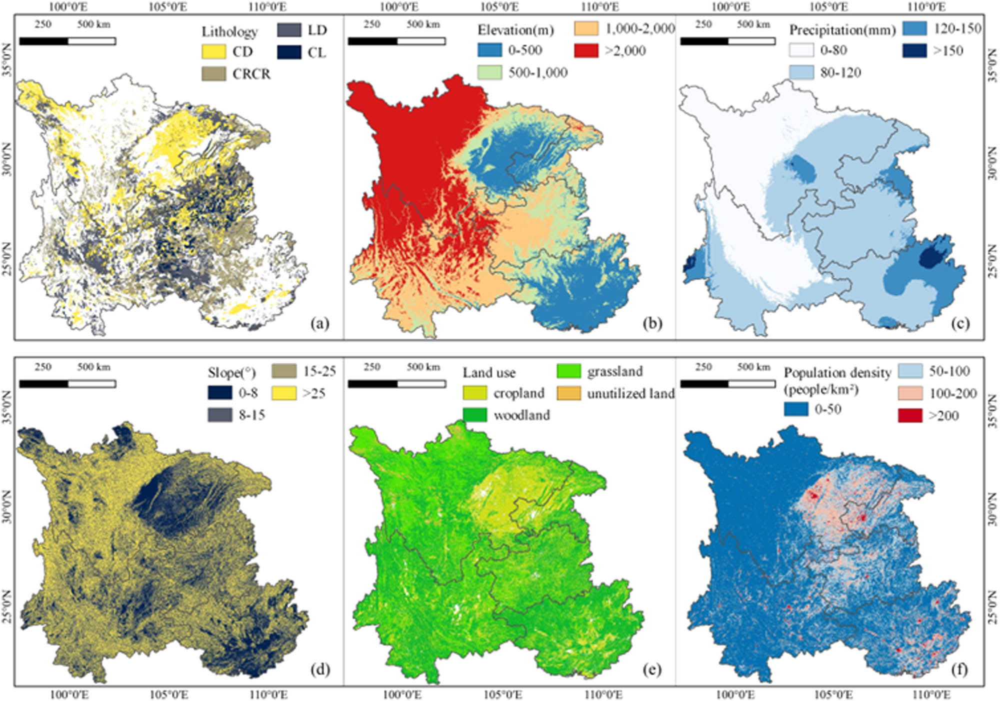
Spatial distributions of influencing factors after grading: (a) lithology, (b) elevation, (c) precipitation, (d) slope, (e) land use, and (f) population density.
2.3.3 Geodetector
Geodetector is an emerging statistical methodology for quantitatively detecting and explaining the driving force and spatial variation behind geographic phenomena. It can identify and quantify the influence of a geographic factor on the spatial distributions of indicator values and to determine its weight. In addition, the interactive detector is capable of calculating and comparing the degree of influence of a single factor, as well as the degree of influence when multiple factors are superimposed. Through this approach, we can determine whether there is an interaction between two factors and assess the strength of the influence. The geodetector model is expressed as follows:
where q is the explanatory power of independent variable factor x on dependent variable y, which ranges from 0 to 1. The larger the value is, the stronger the explanatory power of the influencing factor on rocky desertification is. h is the categorization, stratification, or partitioning of independent variable x and dependent variable y. N
h
and N are the numbers of units in stratum h and the entire area, respectively.
3 Results
3.1 Status of the spatial distribution of rocky desertification
We studied the degree and distribution of rocky desertification in Southwest China through DPM combined with spectral analysis, and the spatial distribution of different degrees of rocky desertification in the southwest region is shown in Figure 5. The total area of rocky desertification in Southwest China is 217530.40 km2, accounting for 15.57% of the total land area of Southwest China. Among them, the areas with slight, moderate, and severe rocky desertification are 176922.22, 15375.55, and 25232.63 km2, respectively, accounting for 81.33, 7.07, and 11.60% of the rocky desertification area, respectively.

Spatial distribution of rocky desertification.
3.2 Spatial distribution of rocky desertification at different elevations
The spatial distribution of rocky desertification in Southwest China varies significantly with altitude, and the rocky desertification area in Southwest China is mainly distributed in regions with altitudes of greater than 1,000 m, covering 171816.73 km2 (accounting for 78.99% of the total area of rocky desertification in Southwest China). In areas with altitudes of less than 500 m, the area of rocky desertification is only 16893.57 km2, accounting for 7.77% of the total area of rocky desertification (Table 3).
Spatial distribution of rocky desertification at different elevations in Southwest China
| Elevation | None | Potential | Slight | Moderate | Severe | |
|---|---|---|---|---|---|---|
| 0–500 (m) | Area (km²) | 234230.26 | 36288.39 | 12209.67 | 2534.28 | 2149.62 |
| Percentage | 31.89 | 8.85 | 7.13 | 17.21 | 8.85 | |
| 500–1,000 (m) | Area (km²) | 166868.90 | 59308.94 | 16960.47 | 2363.36 | 2145.86 |
| Percentage | 22.72 | 14.47 | 9.91 | 16.05 | 8.83 | |
| 1,000–2,000 (m) | Area (km²) | 192699.88 | 105372.98 | 64043.72 | 6059.72 | 9898.30 |
| Percentage | 26.23 | 25.70 | 37.42 | 41.14 | 40.73 | |
| >2,000 (m) | Area (km²) | 140763.43 | 208997.15 | 77936.17 | 3771.21 | 10107.60 |
| Percentage | 19.16 | 50.98 | 45.54 | 25.60 | 41.59 | |
3.3 Spatial distribution of rocky desertification on different slopes
The rocky desertification area in Southwest China is mainly distributed in regions with slopes of greater than 25°, covering 78770.33 km2 (accounting for 36.21% of the total rocky desertification area in the southwest region), with an incidence rate of 16.85%. In addition, the areas without rocky desertification and potential rocky desertification are mainly distributed in regions with slopes of 0°–8°, with a total area of 367938.73 km2, accounting for 26.34% of the area of the southwest region (Table 4).
Spatial distribution of rocky desertification on different slopes in Southwest China
| Slope | None | Potential | Slight | Moderate | Severe | |
|---|---|---|---|---|---|---|
| 0–8 (°) | Area (km²) | 264695.40 | 103243.33 | 44700.17 | 4977.49 | 7349.22 |
| Percentage | 36.04 | 25.19 | 26.13 | 33.81 | 30.26 | |
| 8–15 (°) | Area (km²) | 110315.78 | 58075.58 | 25479.67 | 2530.96 | 3823.33 |
| Percentage | 15.02 | 14.17 | 14.89 | 17.19 | 15.74 | |
| 15–25 (°) | Area (km²) | 136174.39 | 82837.41 | 34877.15 | 2968.59 | 4634.77 |
| Percentage | 18.54 | 20.22 | 20.38 | 20.16 | 19.08 | |
| >25 (°) | Area (km²) | 223175.16 | 165621.10 | 66043.35 | 4245.13 | 8481.85 |
| Percentage | 30.39 | 40.42 | 38.60 | 28.83 | 34.92 | |
3.4 Spatial distribution of rocky desertification in different lithologies
Lithology is a key factor contributing to regional rocky desertification. According to lithology, the rocky desertification area in Southwest China is mainly distributed in regions with carbonate rock sandwiched between clastic rocks, followed by areas with interbedded dolomite and limestone, covering 42363.80 and 38296.05 km2, respectively (accounting for 19.47 and 17.60% of the total area of rocky desertification, respectively). The highest incidence of rocky desertification occurs in continuous dolomite (16.40%), followed by carbonate rock sandwiched between clastic rocks (14.65%). The continuous dolomite has the lowest incidence of rocky desertification (13.01%). It can be seen that carbonate rocks and limestone are the main lithologies for the occurrence of rocky desertification in the southwest region (Table 5).
Spatial distribution of rocky desertification in different lithologies in Southwest China
| Lithology | None | Potential | Slight | Moderate | Severe | |
|---|---|---|---|---|---|---|
| Carbonate rock sandwiched between clastic rocks | Area (km²) | 53523.41 | 34363.43 | 193288.61 | 2861.12 | 5139.25 |
| Percentage | 26.89 | 36.40 | 36.58 | 34.13 | 43.53 | |
| Continuous dolomite | Area (km²) | 63935.48 | 23466.63 | 116493.76 | 1623.32 | 1893.55 |
| Percentage | 32.12 | 24.86 | 22.04 | 19.36 | 16.04 | |
| Continuous limestone | Area (km²) | 11880.15 | 5278.02 | 23574.52 | 869.16 | 810.51 |
| Percentage | 5.97 | 5.59 | 4.46 | 10.37 | 6.87 | |
| Interbedded limestone and dolomite | Area (km²) | 69717.12 | 31304.25 | 195079.38 | 3029.37 | 3962.42 |
| Percentage | 35.02 | 33.16 | 36.92 | 36.14 | 33.56 | |
3.5 Spatial distribution of rocky desertification for different amounts of precipitation
There are significant differences in the spatial distribution of rocky desertification in the southwest region under different precipitation ranges (Table 6). The rocky desertification area in the southwest region is mainly distributed in regions with an average monthly precipitation of 80–120 mm, covering 102993.35 km2 (accounting for 47.35% of the total area of rocky desertification in the southwest region). The occurrence rate of rocky desertification within this precipitation range is 14.10%. This is followed by areas with an average monthly precipitation of less than 80 mm, with a rocky desertification area of 93670.07 km2, accounting for 43.06% of the total rocky desertification area in Southwest China. Based on this, it can be concluded that rocky desertification mainly occurs in areas where the average monthly precipitation is less than 120 mm.
Spatial distribution of rocky desertification for different amounts of precipitation in Southwest China
| Precipitation | None | Potential | Slight | Moderate | Severe | |
|---|---|---|---|---|---|---|
| 0–80 (mm) | Area (km²) | 146434.07 | 213063.82 | 76579.14 | 5006.39 | 12084.53 |
| Percentage | 19.94 | 51.98 | 44.75 | 34.02 | 49.80 | |
| 80–120 (mm) | Area (km²) | 461557.15 | 166013.59 | 85177.28 | 7989.69 | 9826.38 |
| Percentage | 62.85 | 40.50 | 49.78 | 54.30 | 40.49 | |
| 120–150 (mm) | Area (km²) | 113616.09 | 28175.60 | 8719.90 | 1582.35 | 2125.35 |
| Percentage | 15.47 | 6.87 | 5.10 | 10.75 | 8.76 | |
| >150 (mm) | Area (km²) | 12774.07 | 2653.19 | 636.83 | 136.46 | 230.92 |
| Percentage | 1.74 | 0.65 | 0.37 | 0.93 | 0.95 | |
3.6 Spatial distribution of rocky desertification for different population densities
According to Table 7, the area of rocky desertification in Southwest China is not positively correlated with the population density, and there are large differences in the rocky desertification area under different population densities. In the southwest region, rocky desertification mainly occurs in areas where the population density is less than 50 people/km2, and the area of rocky desertification is 161280.38 km2, accounting for 74.14% of the total area of rocky desertification. The fragile ecological environment of the Southwest region, coupled with the region’s low population density, has led to significant challenges in implementing ERPs.
Spatial distribution of rocky desertification for different population densities in Southwest China
| Population density | None | Potential | Slight | Moderate | Severe | |
|---|---|---|---|---|---|---|
| 0–50 (people/km²) | Area (km²) | 450014.02 | 340296.21 | 134101.50 | 9281.56 | 17897.31 |
| Percentage | 61.36 | 83.11 | 78.50 | 63.16 | 73.87 | |
| 50–100 (people/km²) | Area (km²) | 157941.47 | 50743.44 | 26565.52 | 3356.04 | 4027.12 |
| Percentage | 21.53 | 12.39 | 15.55 | 22.84 | 16.62 | |
| 100–200 (people/km²) | Area (km²) | 104190.67 | 15996.32 | 8528.48 | 1633.04 | 1803.58 |
| Percentage | 14.21 | 3.91 | 4.99 | 11.11 | 7.44 | |
| >200 (people/km²) | Area (km²) | 21294.18 | 2421.13 | 1632.51 | 425.39 | 499.23 |
| Percentage | 2.90 | 0.59 | 0.96 | 2.89 | 2.06 | |
Among them, the proportions of slight, moderate, and severe rocky desertification within this population density range are 78.50, 63.16, and 73.87%, respectively. The area with severe rocky desertification and population densities of 50–100 people/km2 is 33948.69 km2, accounting for 15.61% of the total rocky desertification area. The remaining two population density ranges have a smaller rocky desertification area and a lower incidence of rocky desertification.
3.7 Spatial distribution of rocky desertification in different land use types
There are also significant differences in the distribution of rocky desertification in the southwest region under different land use types (Table 8). The rocky desertification area in the southwest region is mainly distributed in the woodland and grassland, with rocky desertification areas of 109694.60 and 87429.17 km2, respectively, accounting for 50.43 and 40.19% of the total rocky desertification area, respectively. The incidence of rocky desertification is the highest in unutilized land (50.15%), but since the area of unutilized land is relatively small, the area of rocky desertification is the smallest, accounting for only 4.10% of the total area of rocky desertification in Southwest China. The next highest incidence of rocky desertification occurs in the grassland (40.19%), and the lowest incidence of rocky desertification occurs in the cropland (1.6%).
Spatial distribution of rocky desertification for different land use types in Southwest China
| Land use | None | Potential | Slight | Moderate | Severe | |
|---|---|---|---|---|---|---|
| Grassland | Area (km²) | 58061.24 | 161753.16 | 72154.40 | 5346.89 | 9927.89 |
| Percentage | 8.29 | 39.53 | 42.28 | 36.44 | 41.04 | |
| Cropland | Area (km²) | 302111.71 | 6417.48 | 2803.10 | 308.29 | 374.27 |
| Percentage | 43.13 | 1.57 | 1.64 | 2.10 | 1.55 | |
| Woodland | Area (km²) | 339970.43 | 232554.06 | 87827.44 | 8920.96 | 12946.20 |
| Percentage | 48.53 | 56.83 | 51.46 | 60.79 | 53.52 | |
| Unutilized land | Area (km²) | 378.38 | 8494.89 | 7889.23 | 98.38 | 939.90 |
| Percentage | 0.05 | 2.08 | 4.62 | 0.67 | 3.89 | |
3.8 Proportion of rocky desertification areas in different classes with different driving factors
According to Figure 6, the spatial distribution characteristics of rocky desertification in Southwest China can be summarized as follows: the rocky desertification area is mainly distributed in regions with altitudes of greater than 1,000 m, accounting for 78.99% of the total rocky desertification area. The rocky desertification area accounts for a relatively large proportion of the area with slopes of >25°, accounting for 36.21% of the total rocky desertification area, while the areas with no rocky desertification and potential rocky desertification are mainly distributed in regions with slopes of 0°–8°, accounting for 26.34% of the total area. In terms of lithology, carbonate rock sandwiched between clastic rocks and continuous limestone is the main rocky desertification distribution area, accounting for 19.47 and 17.60% of the total rocky desertification area, respectively. The rocky desertification area is the largest in regions with an average monthly precipitation of 80–120 mm, accounting for 47.35% of the total rocky desertification area. The area of rocky desertification is the largest in regions with population densities of less than 50 people/km², accounting for 74.14% of the total rocky desertification area. The proportions of rocky desertification area in the woodland and grassland under different land use modes are 50.43 and 40.19%, respectively. In general, it can be concluded that the influence of human activities on the rocky desertification process in the southwest region is weakening, and natural factors are the main driving factors of rocky desertification.

Percentages of areas with different levels of rocky desertification under different influencing factors: (a) elevation, (b) slope, (c) lithology, (d) precipitation, (e) population density, (f) land use types. CRWCR: carbonate rock sandwiched between clastic rocks. CD: continuous dolomite; CL: continuous limestone; and ILAD: interbedded limestone and dolomite.
4 Discussion
4.1 Analysis of single driving factors of spatial distribution and formation of rocky desertification in Southwest China
Geodetector was used to analyze the driving factors of the spatial distribution of rocky desertification in Southwest China. It is able to quantify the extent of the impact of different factors on rock desertification, including the impact of a single factor, the interaction of multiple factors, and so on. This contributes to the understanding of the interrelationships between factors and their respective combined effects on the formation and spatial distribution of rock desertification. The results of the factor detector are presented in Table 9, which shows that the explanatory powers of different factors on the rocky desertification process in Southwest China vary. The influence weights of the factors on the spatial distribution of rocky desertification are as follows: lithology (q = 0.66) > land use (q = 0.45) > slope (q = 0.42) > precipitation (q = 0.22) > elevation (q = 0.21) > population (q = 0.15).
Results of factor detector
| Elevation | Land use | Population density | Precipitation | Lithology | Slope | |
|---|---|---|---|---|---|---|
| q value | 0.21 | 0.45 | 0.15 | 0.22 | 0.66 | 0.42 |
| p value | 0.00 | 0.00 | 0.00 | 0.00 | 0.00 | 0.04 |
The factors affecting the development of rocky desertification mainly include lithological factors. The rocky desertification is mainly developed in pure carbonate rock distribution areas and less rocky desertification occurs in impure carbonate rock distribution areas. The acid-insoluble substance content of pure carbonate rock is only approximately 5%, karst features are strongly developed in such rocks, and the rate of soil formation is very slow. According to previous research, it takes 250000–850000 years to form a 1 m thick layer of soil in karst areas, which is 10–40 times the period in non-karst areas at the same latitude. The purity, structure, and combination of rock types not only strictly affect the speed and mode of karst activity but also directly shape the type, structure, fertility composition, and content of the weathered residual soil and other characteristics. These factors are intertwined and together determine the geomorphology and soil development in rocky areas.
The type of land use is also a main driving factor of the occurrence of rocky desertification. Unreasonable land use by humans results in accelerated rocky desertification. The unreasonable human interferences that destroy vegetation and are more prominent in accelerating soil erosion-based geological processes are as follows: (1) woodland in mountainous areas is degraded to scrub grassland by deforestation, and further deforestation leads to barren grassy slopes. (2) Woodland in mountainous areas is transformed into a sloping arable land via deforestation, and rocky desertification is caused by soil and water erosion. (3) Sloping arable land subjected to long-term water and soil erosion leads to rocky desertification. The landscape in Southwest China is dominated by low and medium mountains, and the local land use types are dominated by mountains and dryland. The forested area in Southwest China accounts for a relatively large proportion of the total area, and the rocky desertification area is mainly distributed in sparse woodland and grassland with more serious vegetation destruction. The woodland–sparse woodland–shrubland–scrubland grassland transformation of the vegetation cover condition drives soil erosion, finally leading to the development of a rocky desertification landscape.
Slope plays an important role in influencing land morphology and the process of rocky desertification, with larger slopes promoting the movement and seepage of water through the soil. Moisture seeps down in the direction of the slope, carrying away nutrients and organic matter from the soil, leading to infertile soil, which in turn affects the growth of vegetation and soil retention. An increase in slope increases the risk of soil erosion. During rainfall, the rate of runoff from the slope increases, and the impact of the water flow on the soil increases, which tends to carry away soil particles, accelerating soil erosion and leading to soil erosion. This can further weaken the surface vegetation cover and accelerate the development of rocky desertification.
4.2 Interactive factor-driven analysis of rocky desertification formation and distribution in Southwest China
Since the rocky desertification process is affected by the interactions of different types of factors, in this article, interaction factor detector analysis in the geodetector was used to determine the dominant interaction factors of rocky desertification. This article aims to assess the explanatory powers of driving factors X1 and X2 on the dependent variable Y when they act together to determine whether they enhance or diminish the degree of influence on Y. The larger the value is, the more significant the extent to which this joint interaction explains Y is comparable to the independent effects of each factor. According to Figure 7, the two pairs of interactive drivers with greater explanatory powers are lithology ∩ land use (q = 0.76) and slope ∩ land use (q = 0.68).

Interactive factor-driven analysis of rocky desertification formation.
Based on the results of the factor detector and the results of the interaction detector (Figure 7), the q-values of the three driving factors of lithology, slope, and land use are larger than those of other single driving factors or interactions between driving factors. Among them, the interaction between the driving factors of lithology and land use is the largest (q = 0.76), which shows that in the southwest region where carbonate rocks are widely distributed, the geological foundation is very fragile, and irrational land use by humans is the primary reason for the formation of rocky desertification in the southwest region. Appropriate slope conditions exacerbate soil erosion and weaken vegetation cover, further promoting the development of rocky desertification.
4.3 Spatial distribution of rocky desertification in relation to lithology and land use type
According to the distribution of rocky desertification in Southwest China under different land use types and lithologies (Table 10), it can be seen that rocky desertification is mainly distributed in the areas where the lithology is carbonate rock sandwiched between clastic rocks and continuous dolomite, and the land use types are grassland and woodland. The area of rocky desertification in areas with carbonate rock sandwiched between clastic rocks ∩ grassland accounts for 20.18% of this area; the area of rocky desertification in areas with continuous dolomite ∩ grassland accounts for 16.61% of this area. Furthermore, the area of rocky desertification in areas with carbonate rock sandwiched between clastic rocks ∩ woodland accounts for 14.24% of the area; and the area of rocky desertification in areas with continuous dolomite ∩ woodland accounts for 11.88% of the area. The highest incidence of rocky desertification among the different land use types occurs in unutilized land. The highest rate of rocky desertification among the different rock types occurs in areas with carbonate rock sandwiched between clastic rocks.
Spatial distribution of rocky desertification in relation to lithology and land use
| Lithology | Land use | None | Potential | Slight | Moderate | Severe | Total |
|---|---|---|---|---|---|---|---|
| Continuity dolomite | Grassland | 246232200.47 | 271593895.73 | 1024391.23 | 2745.11 | 5017.06 | 1032153.41 |
| Cropland | 2661401728.95 | 913641.21 | 148080.31 | 790.81 | 2057.67 | 150928.79 | |
| Woodland | 1103321350.77 | 134832408.21 | 723525.78 | 3783.27 | 10925.83 | 738234.88 | |
| Unutilized land | 2132603.07 | 52960290.92 | 125318.34 | 8.34 | 71.74 | 125398.42 | |
| Continuity limestone | Grassland | 133275407.56 | 256461.87 | 35329.00 | 1706.84 | 2067.28 | 39103.12 |
| Cropland | 494938876.30 | 128006.32 | 10326.39 | 584.05 | 828.72 | 11739.16 | |
| Woodland | 456148209.11 | 408495.06 | 40471.29 | 3215.41 | 5394.05 | 49080.74 | |
| Unutilized land | 98578.45 | 73.40 | 3.00 | 0.00 | 0.00 | 3.00 | |
| Interbedded limestone and dolomite | Grassland | 245486280.96 | 258242889.77 | 611404.20 | 3733.54 | 7855.19 | 622992.93 |
| Cropland | 1444917136.58 | 4626651.99 | 95979.92 | 1032.29 | 4646.94 | 101659.16 | |
| Woodland | 1136188926.28 | 126841125.34 | 580661.52 | 6507.23 | 32516.20 | 619684.96 | |
| Unutilized land | 3305.51 | 16083879.84 | 56200.63 | 27.28 | 631.22 | 56859.14 | |
| Carbonate rock sandwiched with clastic rock | Grassland | 528337453.92 | 55287716.90 | 1172553.73 | 3654.23 | 77578.30 | 1253786.27 |
| Cropland | 1842375523.92 | 575762.12 | 77720.64 | 784.12 | 3495.62 | 82000.37 | |
| Woodland | 2131622510.55 | 19563840.66 | 822744.44 | 6086.17 | 55498.04 | 884328.65 | |
| Unutilized land | 2203908.12 | 16931605.44 | 407204.94 | 54.90 | 37043.12 | 444302.96 |
4.4 Spatial distribution of rocky desertification in relation to slope and land use type
According to the distribution of rocky desertification in areas with different land use types and slopes (Table 11), it can be seen that in areas with slopes of 0°–8°, the area of grassland is the largest (783397.19 km²), accounting for 45.5% of the total area with this slope range, and the highest incidence of rocky desertification occurs in unutilized land. In areas with slopes of 8°–15°, the area of grassland is the largest (619579.97 km²), accounting for 49.51%, and the highest rate of rocky desertification occurs in unutilized land. In areas with slopes of 15°–25°, woodland has the largest area (753364.89 km²), accounting for 47.73% of the total area in this range, and the highest rate of rocky desertification occurs in unutilized land. In areas with slopes of >25°, the largest area is woodland (791693.67 km²), accounting for 45.38% of the total area in this range, and the highest incidence of rocky desertification also occurs in unutilized land.
Spatial distribution of rocky desertification in relation to slope and land use type
| Slope | Land Use | None | Potential | Slight | Moderate | Severe | Total |
|---|---|---|---|---|---|---|---|
| 0°–8° | Grassland | 336746415.17 | 156193944.19 | 754621.44 | 3501.07 | 25274.67 | 783397.19 |
| Cropland | 1936220860.75 | 2305267.76 | 88313.59 | 1086.71 | 3163.80 | 92564.09 | |
| Woodland | 1393150550.79 | 76580020.96 | 565233.19 | 5855.06 | 25999.68 | 597087.92 | |
| Unutilized land | 1672398.23 | 25015671.61 | 154975.75 | 25.46 | 9862.18 | 164863.38 | |
| 8°–15° | Grassland | 227082184.35 | 142836541.77 | 599013.45 | 2486.49 | 18080.03 | 619579.97 |
| Cropland | 1635823945.98 | 1065311.47 | 61299.00 | 687.79 | 2131.94 | 64118.74 | |
| Woodland | 1006435964.19 | 59094481.80 | 417993.58 | 4072.98 | 22315.07 | 444381.63 | |
| Unutilized land | 1211742.48 | 18792724.05 | 117187.51 | 9.92 | 6078.28 | 123275.70 | |
| 15°–25° | Grassland | 279430068.09 | 155198410.26 | 724505.98 | 2922.00 | 25936.91 | 753364.89 |
| Cropland | 1566706506.56 | 1247498.85 | 77980.33 | 771.89 | 2439.60 | 81191.83 | |
| Woodland | 1219044109.53 | 70173749.52 | 553345.06 | 4852.96 | 24865.52 | 583063.54 | |
| Unutilized land | 1008286.99 | 20084577.53 | 149972.35 | 19.38 | 10928.67 | 160920.41 | |
| >25° | Grassland | 310072675.29 | 131152068.05 | 765537.30 | 2930.15 | 23226.23 | 791693.67 |
| Cropland | 1304881952.45 | 1625983.57 | 104514.34 | 644.88 | 3293.60 | 108452.82 | |
| Woodland | 1208650372.19 | 75797616.99 | 630831.20 | 4811.09 | 31153.85 | 666796.14 | |
| Unutilized land | 545967.45 | 22082876.41 | 166591.30 | 35.77 | 10876.95 | 177504.02 |
5 Conclusions
The spatial and temporal evolution of rocky desertification is essentially a process in which human activities interfere with the ecosystem, thereby affecting the direction and process of ecological succession. In this study, RS data were used to quantitatively extract the information about rocky desertification patches, and a geodetector model was used to quantitatively evaluate the overall characteristics of the spatial distribution of rocky desertification and various driving factors to explore the characteristics of the distribution of rocky desertification. Due to the special geomorphologic tectonic unit in Southwest China, the driving factors of rocky desertification in this region are more complicated and diverse. Based on the GIS spatial analysis tool and geodetector model, the following conclusions were obtained:
RS images and GIS spatial analysis tools provide spatial data for the geodetector model. The advantage of the geodetector model lies in its ability to simultaneously consider multiple influencing factors, including qualitative and quantitative factors, and the interactions among them. This helps to reveal the complex correlations and influencing mechanisms behind geographic phenomena. The q-values in the output of the geodetector model have a clear physical meaning, and can be interpreted as the extent to which different factors contribute to the changes in geographic phenomena. This contributes to a deeper understanding of the relative importance of the influencing factors.
The total area of rocky desertification in Southwest China is 217530.4 km², accounting for 15.6% of the total land area of Southwest China. Among them, the areas, with slight, moderate, and severe rocky desertification are 176922.2, 15375.5, and 25232.6 km², respectively, accounting for 81.3, 7.1, and 11.6% of the area of rocky desertification, respectively. There is a large area of rocky desertification in the southwest region, with slight rocky desertification occupying the majority of the area, but the areas with moderate and severe rocky desertification have also affected the environment of the region to a certain extent.
Slight, moderate, and severe rocky desertification mainly occur in areas where the lithology is carbonate rock sandwiched between clastic rocks and continuous limestone. This is related to the geological characteristics of the carbonate rock sandwiched between clastic rocks and continuous limestone, especially their solubility and influence on soil stability, as well as to the various geological processes in geologic history.
The factor detector of the geodetector revealed that the three factors of lithology (q = 0.66), land use type (q = 0.45), and slope (q = 0.42) play the main driving roles in the formation of rocky desertification in Southwest China. The interactive detector further revealed that the combinations of lithology and land use type (q = 0.76) and slope and land use type (q = 0.68) jointly drive the formation of rocky desertification in Southwest China.
Local governments should promote vegetation restoration projects, including planting drought-resistant plants and grasslands, to stabilize soil and improve the land’s ecosystem. Implementing ecological restoration plans involves planting trees, grasslands, and shrubs to restore soil fertility and water retention capacity. Second, it is necessary to strengthen land management and protection measures, including limiting overgrazing, controlling land reclamation, and mining activities, to reduce land degradation and soil erosion.
-
Funding information: This research was funded by “ERP Study in Porous carbonate rock area” (No: F2022405).
-
Author contributions: Conceptualization, methodology, and writing – draft preparation: D. Wei., Y. Chang., D. Song., and H. Kuang; supervision, project administration, and funding acquisition: H. Kuang. All authors have read and agreed to the published version of the manuscript.
-
Conflict of interest: The authors declare no conflict of interest.
References
[1] Gorelick N, Hancher M, Dixon M, Ilyushchenko S, Moore R. Google Earth Engine: Planetary-scale geospatial analysis for everyone. Remote Sens Environ. 2017;202:18–27.10.1016/j.rse.2017.06.031Search in Google Scholar
[2] Mutanga O, Kumar L. Google Earth Engine Applications. Remote Sens. 2019;11(5):591.10.3390/rs11050591Search in Google Scholar
[3] Wu Q, Lane CR, Li X, Zhao K, Zhou Y, Clinton N, et al. Integrating LiDAR data and multi-temporal aerial imagery to map wetland inundation dynamics using Google Earth Engine. Remote Sens Environ. 2019;228:1–13.10.1016/j.rse.2019.04.015Search in Google Scholar PubMed PubMed Central
[4] Duan H, Wang T, Xue X, Yan C. Dynamic monitoring of aeolian desertification based on multiple indicators in Horqin Sandy Land, China. Sci Total Environ. 2019;650:2374–88.10.1016/j.scitotenv.2018.09.374Search in Google Scholar PubMed
[5] Qingsheng L, Gaohuan L, Chong H. Monitoring desertification processes in Mongolian Plateau using MODIS tasseled cap transformation and TGSI time series. J Arid Land. 2018;10:12–26.10.1007/s40333-017-0109-0Search in Google Scholar
[6] Jiang Z, Lian Y, Qin X. Rocky desertification in Southwest China: Impacts, causes, and restoration. Earth-Sci Rev. 2014;132:1–12.10.1016/j.earscirev.2014.01.005Search in Google Scholar
[7] Wenrong D. Temporal and spatial evolution characteristics of vegetation NDVI and its driving factors in Karst area of Southeast Yunnan, China. Res Soil Water Conserv. 2016;54:105–14.Search in Google Scholar
[8] Yuan DX. Rock desertification in the subtropical karst of south China. Z Geomorphol. 1997;108:81–90.Search in Google Scholar
[9] Jiang Z, Yuan D. Rocky desertification in southwest karst region and its comprehensive management. China Geological Survey Bureau Karst Groundwater and Desertification Research Papers of China (in Chinese). Guangxi Science and Technology; 2003. p. 25–33.Search in Google Scholar
[10] Yan T, Xue J, Zhou Z, Wu Y. Effects of biochar-based fertilizer on soil bacterial network structure in a karst mountainous area. CATENA. 2021;206:105535.10.1016/j.catena.2021.105535Search in Google Scholar
[11] Xu D, You X, Xia C. Assessing the spatial-temporal pattern and evolution of areas sensitive to land desertification in North China. Ecol Indic. 2019;97:150–8. 12.10.1016/j.ecolind.2018.10.005Search in Google Scholar
[12] Xiaoyan W. Comprehensive treatment of rocky desertification in karst mountain areas. Chin J Agric Resour Reg Plan. 2010;31(4):76–80.Search in Google Scholar
[13] Tong X, Wang K, Yue Y, Brandt M, Liu B, Zhang C, et al. Quantifying the effectiveness of ecological restoration projects on long-term vegetation dynamics in the karst regions of Southwest China. Int J Appl Earth Observ Geoinf. 2017;54:105–13.10.1016/j.jag.2016.09.013Search in Google Scholar
[14] Li YB, Shao JA, Yang H, Bai XY. The relations between land use and karst rocky desertification in a typical karst area, China. Environ Geol. 2009;57:621–7.10.1007/s00254-008-1331-zSearch in Google Scholar
[15] Jiang Z, Li X, Hu B. Rocky desertification in karst mountainous areas in Guangxi and its comprehensive treatment. Beijing: Science Press; 2011. p. 33–40.Search in Google Scholar
[16] Feng K, Wang T, Liu S, Kang W, Chen X, Guo Z, et al. Monitoring desertification using machine-learning techniques with multiple indicators derived from MODIS images in Mu Us Sandy Land, China. Remote Sens. 2022;14:2663.10.3390/rs14112663Search in Google Scholar
[17] Bai X, Xiong K, Li Y, Anjul L. Quantitative study on spatial difference of rocky desertification and population factors in different karst mountain areas. J Mt Sci. 2006;24(2):242–8.Search in Google Scholar
[18] Zeng F, Jiang Z, Shen L, Chen W, Yang Q, Zhang C. Assessment of multiple and interacting modes of soil loss in the karst critical zone, Southwest China (SWC). Geomorphology. 2018;322:97–106.10.1016/j.geomorph.2018.08.043Search in Google Scholar
[19] Luo XL, Bai XY, Tan Q, Chen H, Ran C, Xi HP. Effect of lithology background on the correlation between soil erosion and rock desertification. Acta Ecol Sin. 2018;38(24):8717–25.10.5846/stxb201807251583Search in Google Scholar
[20] Luo XL, Wang SJ, Bai XY, Tan Q, Ran C, Chen H, et al. Analysis on the spatio- temporal evolution process of rocky desertification in Southwest Karst area. Acta Ecol Sin. 2021;41(2):680–93.Search in Google Scholar
[21] Wang S, Liu Q, Zhang DL. Karst rocky desertification in southwestern China: geomorphology, landuse, impact and rehabilitation. Land Degrad Dev. 2004;15(2):115–21.10.1002/ldr.592Search in Google Scholar
[22] Yunlong C. Preliminary research on ecological reconstruction in Karst mountain poverty areas of SouthWest China. Adv Earth Sci. 1996;11:602–6.Search in Google Scholar
[23] Chen HL. A study on basic territorial differences in the man-land system in Karst Regions of South China. Geogr Res. 2000;19(1):73–9.Search in Google Scholar
[24] Jiang Y, Li L, Groves C, Yuan D, Kambesis P. Relationships between rocky desertification and spatial pattern of land use in typical karst area, Southwest China. Environmental earth sciences. 2009 Dec;59:881–90.10.1007/s12665-009-0083-8Search in Google Scholar
[25] Xu D, Kang X, Qiu D, Zhuang D, Pan J. Quantitative assessment of desertification using landsat data on a regional scale – A case study in the Ordos Plateau, China. Sensors. 2009;9:1738–53.10.3390/s90301738Search in Google Scholar PubMed PubMed Central
[26] Meng X, Gao X, Li S, Li S, Lei J. Monitoring desertification in Mongolia based on Landsat images and Google Earth Engine from 1990 to 2020 - ScienceDirect. Ecol Indic. 2021;129:107908.10.1016/j.ecolind.2021.107908Search in Google Scholar
[27] Liu P. A survey of remote-sensing big data. Front Environ Sci. 2015;3:45.10.3389/fenvs.2015.00045Search in Google Scholar
[28] Tamiminia H, Salehi B, Mahdianpari M, Quackenbush LJ, Adeli S, Brisco B. Google earth engine for geo-big data applications: A meta-analysis and systematic review. Isprs J Photogramm Remote Sens. 2020;164:152–70.10.1016/j.isprsjprs.2020.04.001Search in Google Scholar
[29] Zhao R, Zhan L, Yao M, Yang L. A geographically weighted regression model augmented by Geodetector analysis and principal component analysis for the spatial distribution of PM2.5. Sustain Cities Soc. 2020;56:102106.10.1016/j.scs.2020.102106Search in Google Scholar
[30] Zhou X, Wen H, Zhang Y, Xu J, Zhang W. Landslide susceptibility mapping using hybrid random forest with GeoDetector and RFE for factor optimization. Geosci Front. 2021;12:101211.10.1016/j.gsf.2021.101211Search in Google Scholar
[31] Rong G, Li K, Han L, Alu S, Zhang Y. Hazard mapping of the rainfall–landslides disaster chain based on geodetector and Bayesian network models in Shuicheng County, China. Water. 2020;12:2572.10.3390/w12092572Search in Google Scholar
[32] Clinton NE, Stuhlmacher M, Miles AF, Aragon NU, Wagner MA, Georgescu MR, et al. A global geospatial ecosystem services estimate of urban agriculture. Earth’s Future. 2018;6(1):40–60.10.1002/2017EF000536Search in Google Scholar
[33] Azzari G, Lobell D. Landsat-based classification in the cloud: An opportunity for a paradigm shift in land cover monitoring. Remote Sens Environ. 2017;202:64–74.10.1016/j.rse.2017.05.025Search in Google Scholar
[34] Liu X, Hu G, Chen Y, Li X, Xu X, Li S, et al. High-resolution multi-temporal mapping of global urban land using Landsat images based on the Google Earth Engine Platform. Remote Sens Environ. 2018;209:227–39.10.1016/j.rse.2018.02.055Search in Google Scholar
[35] Cheng F, Lu H, Ren H, Zhou L, Zhang L, Li J, et al. Integrated emergy and economic evaluation of three typical rocky desertification control modes in karst areas of Guizhou Province, China. J Clean Prod. 2017;161:1104–28.10.1016/j.jclepro.2017.05.065Search in Google Scholar
[36] Sharma KK, Verdon-Kidd DC, Magee AD. The influence of large-scale climate modes on tropical cyclone tracks in the southwest Pacific. Nat Hazards. 2023;118(3):2285–307.10.1007/s11069-023-06091-xSearch in Google Scholar
[37] Guo B, Yang F, Fan Y, Zang W. The dominant driving factors of rocky desertification and their variations in typical mountainous karst areas of southwest China in the context of global change. Catena. 2023;220:106674.10.1016/j.catena.2022.106674Search in Google Scholar
[38] Zhang X, Yue Y, Tong X, Wang K, Qi X, Deng C, et al. Eco-engineering controls vegetation trends in southwest China karst. Sci Total Env. 2021;770:145160.10.1016/j.scitotenv.2021.145160Search in Google Scholar PubMed
[39] Sheng M, Xiong K, Wang L, Li X, Li R, Tian X. Response of soil physical and chemical properties to Rocky desertification succession in South China Karst. Carbonates Evaporites. 2018;33:15–28.10.1007/s13146-016-0295-4Search in Google Scholar
[40] Bian J, Li A, Lei G, Zhang Z, Nan X. Global high-resolution mountain green cover index mapping based on Landsat images and Google Earth Engine. ISPRS J Photogramm Remote Sens. 2020;162:63–76.10.1016/j.isprsjprs.2020.02.011Search in Google Scholar
[41] Yan Y, Zhuang Q, Zan C, Ren J, Yang L, Wen Y, et al. Using the Google Earth Engine to rapidly monitor impacts of geohazards on ecological quality in highly susceptible areas. Ecol Indic. 2021;132:108258.10.1016/j.ecolind.2021.108258Search in Google Scholar
[42] Yangbing LI, Guangjie L, Anyun C, Jingan S, Xiaoyong B, Shijie W. A typical case study on evolution of karst rocky desertification in Houzhaihe, Puding County, central Guizhou Province, China. Geogr Res. 2013;32:828–38.Search in Google Scholar
[43] Xi H, Wang S, Bai X, Tang H, Wu L, Chen F, et al. Spatio-temporal characteristics of rocky desertification in typical Karst areas of Southwest China: A case study of Puding County, Guizhou Province. Acta Ecol Sin. 2018;38(24):8919–33.10.5846/stxb201806011216Search in Google Scholar
© 2024 the author(s), published by De Gruyter
This work is licensed under the Creative Commons Attribution 4.0 International License.
Articles in the same Issue
- Regular Articles
- Theoretical magnetotelluric response of stratiform earth consisting of alternative homogeneous and transitional layers
- The research of common drought indexes for the application to the drought monitoring in the region of Jin Sha river
- Evolutionary game analysis of government, businesses, and consumers in high-standard farmland low-carbon construction
- On the use of low-frequency passive seismic as a direct hydrocarbon indicator: A case study at Banyubang oil field, Indonesia
- Water transportation planning in connection with extreme weather conditions; case study – Port of Novi Sad, Serbia
- Zircon U–Pb ages of the Paleozoic volcaniclastic strata in the Junggar Basin, NW China
- Monitoring of mangrove forests vegetation based on optical versus microwave data: A case study western coast of Saudi Arabia
- Microfacies analysis of marine shale: A case study of the shales of the Wufeng–Longmaxi formation in the western Chongqing, Sichuan Basin, China
- Multisource remote sensing image fusion processing in plateau seismic region feature information extraction and application analysis – An example of the Menyuan Ms6.9 earthquake on January 8, 2022
- Identification of magnetic mineralogy and paleo-flow direction of the Miocene-quaternary volcanic products in the north of Lake Van, Eastern Turkey
- Impact of fully rotating steel casing bored pile on adjacent tunnels
- Adolescents’ consumption intentions toward leisure tourism in high-risk leisure environments in riverine areas
- Petrogenesis of Jurassic granitic rocks in South China Block: Implications for events related to subduction of Paleo-Pacific plate
- Differences in urban daytime and night block vitality based on mobile phone signaling data: A case study of Kunming’s urban district
- Random forest and artificial neural network-based tsunami forests classification using data fusion of Sentinel-2 and Airbus Vision-1 satellites: A case study of Garhi Chandan, Pakistan
- Integrated geophysical approach for detection and size-geometry characterization of a multiscale karst system in carbonate units, semiarid Brazil
- Spatial and temporal changes in ecosystem services value and analysis of driving factors in the Yangtze River Delta Region
- Deep fault sliding rates for Ka-Ping block of Xinjiang based on repeating earthquakes
- Improved deep learning segmentation of outdoor point clouds with different sampling strategies and using intensities
- Platform margin belt structure and sedimentation characteristics of Changxing Formation reefs on both sides of the Kaijiang-Liangping trough, eastern Sichuan Basin, China
- Enhancing attapulgite and cement-modified loess for effective landfill lining: A study on seepage prevention and Cu/Pb ion adsorption
- Flood risk assessment, a case study in an arid environment of Southeast Morocco
- Lower limits of physical properties and classification evaluation criteria of the tight reservoir in the Ahe Formation in the Dibei Area of the Kuqa depression
- Evaluation of Viaducts’ contribution to road network accessibility in the Yunnan–Guizhou area based on the node deletion method
- Permian tectonic switch of the southern Central Asian Orogenic Belt: Constraints from magmatism in the southern Alxa region, NW China
- Element geochemical differences in lower Cambrian black shales with hydrothermal sedimentation in the Yangtze block, South China
- Three-dimensional finite-memory quasi-Newton inversion of the magnetotelluric based on unstructured grids
- Obliquity-paced summer monsoon from the Shilou red clay section on the eastern Chinese Loess Plateau
- Classification and logging identification of reservoir space near the upper Ordovician pinch-out line in Tahe Oilfield
- Ultra-deep channel sand body target recognition method based on improved deep learning under UAV cluster
- New formula to determine flyrock distance on sedimentary rocks with low strength
- Assessing the ecological security of tourism in Northeast China
- Effective reservoir identification and sweet spot prediction in Chang 8 Member tight oil reservoirs in Huanjiang area, Ordos Basin
- Detecting heterogeneity of spatial accessibility to sports facilities for adolescents at fine scale: A case study in Changsha, China
- Effects of freeze–thaw cycles on soil nutrients by soft rock and sand remodeling
- Vibration prediction with a method based on the absorption property of blast-induced seismic waves: A case study
- A new look at the geodynamic development of the Ediacaran–early Cambrian forearc basalts of the Tannuola-Khamsara Island Arc (Central Asia, Russia): Conclusions from geological, geochemical, and Nd-isotope data
- Spatio-temporal analysis of the driving factors of urban land use expansion in China: A study of the Yangtze River Delta region
- Selection of Euler deconvolution solutions using the enhanced horizontal gradient and stable vertical differentiation
- Phase change of the Ordovician hydrocarbon in the Tarim Basin: A case study from the Halahatang–Shunbei area
- Using interpretative structure model and analytical network process for optimum site selection of airport locations in Delta Egypt
- Geochemistry of magnetite from Fe-skarn deposits along the central Loei Fold Belt, Thailand
- Functional typology of settlements in the Srem region, Serbia
- Hunger Games Search for the elucidation of gravity anomalies with application to geothermal energy investigations and volcanic activity studies
- Addressing incomplete tile phenomena in image tiling: Introducing the grid six-intersection model
- Evaluation and control model for resilience of water resource building system based on fuzzy comprehensive evaluation method and its application
- MIF and AHP methods for delineation of groundwater potential zones using remote sensing and GIS techniques in Tirunelveli, Tenkasi District, India
- New database for the estimation of dynamic coefficient of friction of snow
- Measuring urban growth dynamics: A study in Hue city, Vietnam
- Comparative models of support-vector machine, multilayer perceptron, and decision tree predication approaches for landslide susceptibility analysis
- Experimental study on the influence of clay content on the shear strength of silty soil and mechanism analysis
- Geosite assessment as a contribution to the sustainable development of Babušnica, Serbia
- Using fuzzy analytical hierarchy process for road transportation services management based on remote sensing and GIS technology
- Accumulation mechanism of multi-type unconventional oil and gas reservoirs in Northern China: Taking Hari Sag of the Yin’e Basin as an example
- TOC prediction of source rocks based on the convolutional neural network and logging curves – A case study of Pinghu Formation in Xihu Sag
- A method for fast detection of wind farms from remote sensing images using deep learning and geospatial analysis
- Spatial distribution and driving factors of karst rocky desertification in Southwest China based on GIS and geodetector
- Physicochemical and mineralogical composition studies of clays from Share and Tshonga areas, Northern Bida Basin, Nigeria: Implications for Geophagia
- Geochemical sedimentary records of eutrophication and environmental change in Chaohu Lake, East China
- Research progress of freeze–thaw rock using bibliometric analysis
- Mixed irrigation affects the composition and diversity of the soil bacterial community
- Examining the swelling potential of cohesive soils with high plasticity according to their index properties using GIS
- Geological genesis and identification of high-porosity and low-permeability sandstones in the Cretaceous Bashkirchik Formation, northern Tarim Basin
- Usability of PPGIS tools exemplified by geodiscussion – a tool for public participation in shaping public space
- Efficient development technology of Upper Paleozoic Lower Shihezi tight sandstone gas reservoir in northeastern Ordos Basin
- Assessment of soil resources of agricultural landscapes in Turkestan region of the Republic of Kazakhstan based on agrochemical indexes
- Evaluating the impact of DEM interpolation algorithms on relief index for soil resource management
- Petrogenetic relationship between plutonic and subvolcanic rocks in the Jurassic Shuikoushan complex, South China
- A novel workflow for shale lithology identification – A case study in the Gulong Depression, Songliao Basin, China
- Characteristics and main controlling factors of dolomite reservoirs in Fei-3 Member of Feixianguan Formation of Lower Triassic, Puguang area
- Impact of high-speed railway network on county-level accessibility and economic linkage in Jiangxi Province, China: A spatio-temporal data analysis
- Estimation model of wild fractional vegetation cover based on RGB vegetation index and its application
- Lithofacies, petrography, and geochemistry of the Lamphun oceanic plate stratigraphy: As a record of the subduction history of Paleo-Tethys in Chiang Mai-Chiang Rai Suture Zone of Thailand
- Structural features and tectonic activity of the Weihe Fault, central China
- Application of the wavelet transform and Hilbert–Huang transform in stratigraphic sequence division of Jurassic Shaximiao Formation in Southwest Sichuan Basin
- Structural detachment influences the shale gas preservation in the Wufeng-Longmaxi Formation, Northern Guizhou Province
- Distribution law of Chang 7 Member tight oil in the western Ordos Basin based on geological, logging and numerical simulation techniques
- Evaluation of alteration in the geothermal province west of Cappadocia, Türkiye: Mineralogical, petrographical, geochemical, and remote sensing data
- Numerical modeling of site response at large strains with simplified nonlinear models: Application to Lotung seismic array
- Quantitative characterization of granite failure intensity under dynamic disturbance from energy standpoint
- Characteristics of debris flow dynamics and prediction of the hazardous area in Bangou Village, Yanqing District, Beijing, China
- Rockfall mapping and susceptibility evaluation based on UAV high-resolution imagery and support vector machine method
- Statistical comparison analysis of different real-time kinematic methods for the development of photogrammetric products: CORS-RTK, CORS-RTK + PPK, RTK-DRTK2, and RTK + DRTK2 + GCP
- Hydrogeological mapping of fracture networks using earth observation data to improve rainfall–runoff modeling in arid mountains, Saudi Arabia
- Petrography and geochemistry of pegmatite and leucogranite of Ntega-Marangara area, Burundi, in relation to rare metal mineralisation
- Prediction of formation fracture pressure based on reinforcement learning and XGBoost
- Hazard zonation for potential earthquake-induced landslide in the eastern East Kunlun fault zone
- Monitoring water infiltration in multiple layers of sandstone coal mining model with cracks using ERT
- Study of the patterns of ice lake variation and the factors influencing these changes in the western Nyingchi area
- Productive conservation at the landslide prone area under the threat of rapid land cover changes
- Sedimentary processes and patterns in deposits corresponding to freshwater lake-facies of hyperpycnal flow – An experimental study based on flume depositional simulations
- Study on time-dependent injectability evaluation of mudstone considering the self-healing effect
- Detection of objects with diverse geometric shapes in GPR images using deep-learning methods
- Behavior of trace metals in sedimentary cores from marine and lacustrine environments in Algeria
- Spatiotemporal variation pattern and spatial coupling relationship between NDVI and LST in Mu Us Sandy Land
- Formation mechanism and oil-bearing properties of gravity flow sand body of Chang 63 sub-member of Yanchang Formation in Huaqing area, Ordos Basin
- Diagenesis of marine-continental transitional shale from the Upper Permian Longtan Formation in southern Sichuan Basin, China
- Vertical high-velocity structures and seismic activity in western Shandong Rise, China: Case study inspired by double-difference seismic tomography
- Spatial coupling relationship between metamorphic core complex and gold deposits: Constraints from geophysical electromagnetics
- Disparities in the geospatial allocation of public facilities from the perspective of living circles
- Research on spatial correlation structure of war heritage based on field theory. A case study of Jinzhai County, China
- Formation mechanisms of Qiaoba-Zhongdu Danxia landforms in southwestern Sichuan Province, China
- Magnetic data interpretation: Implication for structure and hydrocarbon potentiality at Delta Wadi Diit, Southeastern Egypt
- Deeply buried clastic rock diagenesis evolution mechanism of Dongdaohaizi sag in the center of Junggar fault basin, Northwest China
- Application of LS-RAPID to simulate the motion of two contrasting landslides triggered by earthquakes
- The new insight of tectonic setting in Sunda–Banda transition zone using tomography seismic. Case study: 7.1 M deep earthquake 29 August 2023
- The critical role of c and φ in ensuring stability: A study on rockfill dams
- Evidence of late quaternary activity of the Weining-Shuicheng Fault in Guizhou, China
- Extreme hydroclimatic events and response of vegetation in the eastern QTP since 10 ka
- Spatial–temporal effect of sea–land gradient on landscape pattern and ecological risk in the coastal zone: A case study of Dalian City
- Study on the influence mechanism of land use on carbon storage under multiple scenarios: A case study of Wenzhou
- A new method for identifying reservoir fluid properties based on well logging data: A case study from PL block of Bohai Bay Basin, North China
- Comparison between thermal models across the Middle Magdalena Valley, Eastern Cordillera, and Eastern Llanos basins in Colombia
- Mineralogical and elemental analysis of Kazakh coals from three mines: Preliminary insights from mode of occurrence to environmental impacts
- Chlorite-induced porosity evolution in multi-source tight sandstone reservoirs: A case study of the Shaximiao Formation in western Sichuan Basin
- Predicting stability factors for rotational failures in earth slopes and embankments using artificial intelligence techniques
- Origin of Late Cretaceous A-type granitoids in South China: Response to the rollback and retreat of the Paleo-Pacific plate
- Modification of dolomitization on reservoir spaces in reef–shoal complex: A case study of Permian Changxing Formation, Sichuan Basin, SW China
- Geological characteristics of the Daduhe gold belt, western Sichuan, China: Implications for exploration
- Rock physics model for deep coal-bed methane reservoir based on equivalent medium theory: A case study of Carboniferous-Permian in Eastern Ordos Basin
- Enhancing the total-field magnetic anomaly using the normalized source strength
- Shear wave velocity profiling of Riyadh City, Saudi Arabia, utilizing the multi-channel analysis of surface waves method
- Effect of coal facies on pore structure heterogeneity of coal measures: Quantitative characterization and comparative study
- Inversion method of organic matter content of different types of soils in black soil area based on hyperspectral indices
- Detection of seepage zones in artificial levees: A case study at the Körös River, Hungary
- Tight sandstone fluid detection technology based on multi-wave seismic data
- Characteristics and control techniques of soft rock tunnel lining cracks in high geo-stress environments: Case study of Wushaoling tunnel group
- Influence of pore structure characteristics on the Permian Shan-1 reservoir in Longdong, Southwest Ordos Basin, China
- Study on sedimentary model of Shanxi Formation – Lower Shihezi Formation in Da 17 well area of Daniudi gas field, Ordos Basin
- Multi-scenario territorial spatial simulation and dynamic changes: A case study of Jilin Province in China from 1985 to 2030
- Review Articles
- Major ascidian species with negative impacts on bivalve aquaculture: Current knowledge and future research aims
- Prediction and assessment of meteorological drought in southwest China using long short-term memory model
- Communication
- Essential questions in earth and geosciences according to large language models
- Erratum
- Erratum to “Random forest and artificial neural network-based tsunami forests classification using data fusion of Sentinel-2 and Airbus Vision-1 satellites: A case study of Garhi Chandan, Pakistan”
- Special Issue: Natural Resources and Environmental Risks: Towards a Sustainable Future - Part I
- Spatial-temporal and trend analysis of traffic accidents in AP Vojvodina (North Serbia)
- Exploring environmental awareness, knowledge, and safety: A comparative study among students in Montenegro and North Macedonia
- Determinants influencing tourists’ willingness to visit Türkiye – Impact of earthquake hazards on Serbian visitors’ preferences
- Application of remote sensing in monitoring land degradation: A case study of Stanari municipality (Bosnia and Herzegovina)
- Optimizing agricultural land use: A GIS-based assessment of suitability in the Sana River Basin, Bosnia and Herzegovina
- Assessing risk-prone areas in the Kratovska Reka catchment (North Macedonia) by integrating advanced geospatial analytics and flash flood potential index
- Analysis of the intensity of erosive processes and state of vegetation cover in the zone of influence of the Kolubara Mining Basin
- GIS-based spatial modeling of landslide susceptibility using BWM-LSI: A case study – city of Smederevo (Serbia)
- Geospatial modeling of wildfire susceptibility on a national scale in Montenegro: A comparative evaluation of F-AHP and FR methodologies
- Geosite assessment as the first step for the development of canyoning activities in North Montenegro
- Urban geoheritage and degradation risk assessment of the Sokograd fortress (Sokobanja, Eastern Serbia)
- Multi-hazard modeling of erosion and landslide susceptibility at the national scale in the example of North Macedonia
- Understanding seismic hazard resilience in Montenegro: A qualitative analysis of community preparedness and response capabilities
- Forest soil CO2 emission in Quercus robur level II monitoring site
- Characterization of glomalin proteins in soil: A potential indicator of erosion intensity
- Power of Terroir: Case study of Grašac at the Fruška Gora wine region (North Serbia)
- Special Issue: Geospatial and Environmental Dynamics - Part I
- Qualitative insights into cultural heritage protection in Serbia: Addressing legal and institutional gaps for disaster risk resilience