Future short-term estimation of flowrate of the Euphrates river catchment located in Al-Najaf Governorate, Iraq through using weather data and statistical downscaling model
-
Hayder H. Kareem
 and
Aseel A. Alkatib
and
Aseel A. Alkatib

Abstract
The issue of global warming has negatively affected the global climate, which caused a decrease in the amount of precipitation and a significant increase in temperatures and evaporation rates. Iraq suffers from poor rainfall, which exacerbates the problem of declining water levels in rivers and the drying up of some tributaries. The Euphrates river, which passes through the eastern side of the Al-Najaf Governorate, is the case study in the current research. A statistical downscaling model is created for rainfall data from 2010 to 2020 with the aim of predicting the future precipitation biennially from 2022 to 2028. The model is calibrated and reflects close results with observations with high accuracy and reliability. The future precipitation levels are transformed after multiplying these levels by the total surface areas of the Euphrates river and its tributaries, and the value of future flowrates to be added to the Euphrates river is estimated. The results showed that the Euphrates river will receive a flowrate of 1,535,945 m3 in 2026, which is the highest value when compared with the values of flowrate for the years 2022, 2024, and 2028, which are estimated at 1,475,072, 1,456,037, and 1,378,403 m3, respectively.
1 Introduction
Global climate change is expected to lead to climatic and hydrological phenomenal impacts that are difficult to predict due to its extreme extremism and do not follow a scientific behavior or method that makes these phenomena under control. Global warming is one of the most important and prominent phenomena that the global climate is experiencing at the present time, as it has greatly affected the change in precipitation rates and temperatures and made these parameters follow an extreme path, causing the complexity of the hydrological cycle in nature [1,2]. The International Panel on Climate Change now claims that “there is new and more robust evidence that most of the heat observed over the last 50 years can be attributed to human activities” [3]. These changes have led to many environmental risks toward human health, such as depletion of the ozone layer, loss of biodiversity [4], pressures on food-producing systems, and the global spread of infectious diseases [3]. At present, there is a neglected aspect of the climate change problem, fewer research deal with the impacts of climate change on health, food availability, economic growth, migration, security, social change, and public goods such as drinking water compared to that on geophysical changes linked to global warming. The World Health Organization has estimated that 160,000 deaths have occurred since 1950, directly related to climate change, and many believe that these are inaccurate estimates. Research conducted at the Hoover Institute by economist Thomas Moore indicated that global warming would lead to high death rates in the world if rapid and serious scientific measures were not taken to reduce the severity of this phenomenon [5].
Despite the hydrological complexities of the climate as a result of external factors and phenomena that are affected by it, the process of predicting future events remains under control, and the correct and accurate prediction to a large extent can be made for those events that the planet may encounter. Statistical downscaling models (SDSMs) represent one of the most important techniques recently used that can be adopted to predict hydrological events through identifying/providing those parameters needed by the statistical/hydrological models [6,7]. The spatial coordinates of the area to be predicted of its future events are important in increasing the accuracy of the obtained results. The flow of rivers and its vulnerability to climate changes need to be studied in order to predict potential floods in the future. Through the use of the downscaling statistical models based on spatial coordinates, it is possible to simulate the flow of rivers, lakes, and water bodies. The flow of a river is greatly affected by the factors that the atmosphere suffers from, which makes it permanently variable in the level of water and that requires a simulation of the hydraulic head in order to calculate the flow. Since the rivers have running water, the changes in the hydraulic parameters of the soil and the quality of the soil will be ineffective in the quantities of flow, as the soil is saturated with water and its physical properties are virtually constant and unchanging over time [8,9].
The subterranean and surface areas represent the areas most affected by the extremism of hydrological events resulting from climate change, which gives it the utmost importance to protect against these changes in order to preserve the water sources at a minimum level of vulnerability. The space for climate impacts and extreme weather events have gained the highest priority and importance among hydrologists in recent decades, as the fluctuations in climate directly affect river flows, such as the phenomenon of tension and tides in lakes and oceans. Studies that are concerned with studying the relationship between the flow of water in rivers, lakes, and water bodies and changes in the atmosphere that cause predictive climate changes (by using downscaling statistical models) are few and limited. These studies depend largely on the spatial location and the observed data for the concerned area, as well as some parameters that need to be provided for the purpose of applying theoretical equations [10,11,12]. Recent studies dealing with watersheds in semi-arid regions to estimate the value of flow have been using the artificial neural network, which includes dividing the data range into a set of miniature statistical ranges and simulating water flow within the monsoon period in order to study the effect of waves and its velocity over the flow value [13,14,15]. Some scientists have relied on the temperatures acquired by seawater which through it can know the seasonal or monthly variables that are to be applied to create the SDSMs used to predict the value of the flow [16]. In Britain, the monthly flowrate values were predicted through the use of SDSMs that depend upon the use of atmospheric data for the local climate surrounding the watersheds and the regional climate that is affected by hydrological phenomena, as the variation in the results was remarkable due to the fluctuation of the Arctic weather, which in turn showed climatic signals that led to the formation of a chart that helped in predicting the monthly and seasonal flow values of the studied rivers [17,18,19]. The effect of climatic fluctuations experienced by the atmosphere and its reflection on the current flows in rivers, lakes, and sedimentary plankton in the waters of these rivers have been studied using SDSMs, where the results showed that the changes to the atmosphere affect the variation of annual current discharges in the rivers at a rate ranging between 32–56% in Siberia and Iceland, indicating that there is no control over the accurate estimation of the amounts of flow in these rivers [20,21].
In the last decades of the twentieth century, the phenomenon of climate change began to take a great deal in its impact on temperatures and rain rates, and the problem of global climate fluctuations began to exacerbate in a complex way in the first decades of the twenty-first century. Changes in the atmosphere have led to complications in the climatic characteristics, which have a negative impact on the noticeable increase in the global temperature and a severe decrease in the rainfall as this was evident in the decrease and dryness of many watersheds and rivers in the climatically classified areas as arid or semi-arid. It shows signs of declining water quantities or droughts, even in slight climate changes. Good and sustainable management of surface and groundwater resources requires an in-depth understanding of the relationship between climate variables, hydrological systems, and human influences, which will result in preserving the durability of those vital resources that humanity needs to sustain life on Earth [22]. SDSMs aim to represent the climatic state of a region by predicting the future estimates of weather (such as the rainfall or temperature events), which will provide a clear pattern of the likely future climate change. Knowing the independent changes of the weather will enable scientists to control the environmental and hydrological impact in addition to assessing the potential effects of bad climatic future events [23].
The Euphrates river suffers from an exacerbated water scarcity as a result of the excessive and unplanned use of all daily needs such as agriculture, industry, domestic use, and drinking. In addition, the weather in Iraq in general and the study area in particular, is very bad, as it suffers from a lack of rain and a significant increase in temperature, which sometimes reaches more than 50°C, which creates great pressure on the Euphrates river through a remarkable increase in evaporation rates. The Governorate of Al-Najaf is characterized by a large number of visitors, whether from inside or outside Iraq, due to the presence of many religious places, where the number of visitors sometimes reaches more than 5 million visitors annually, which creates another pressure on the levels of running water in the Euphrates river. All of the above called for the provision of a study explaining the potential future impact that the Euphrates river may suffer in order to shed light on the scenarios and measures that can be used by decision-makers to pay potential damages to Al-Najaf Governorate and its residents, as well as to maintain the levels of the Euphrates river in a manner that secures the needs of population essential to their lives.
The main objective of this study is to estimate the flowrate values that will be acquired by the Euphrates river in its two branches (Al-Kufa and Al-Abbasiya rivers with their branches) within the borders of the Al-Najaf Governorate for the future short-term period (2022–2028), forecasted every two years. To determine the flowrate value, the precipitation data for the period 2010–2020 will be used with the aim of predicting the short-term future values of rainfall events for the years 2022, 2024, 2026, and 2028 that the Euphrates river is likely to be exposed to, through which the quantities of water added to the Euphrates river can be determined, and this will provide a short-term future study of the events that the Euphrates river may encounter in the future.
2 The Euphrates river “region of interest”
The Euphrates river is one of the large rivers in southwestern Asia and the largest river on the Arab plate. The river originates from the Taurus Mountains in Turkey and consists of two rivers in Asia minor: Murad Sow (meaning the water of the destination) to the east, and its source is between Lake Van and Mount Ararat in Armenia, and the village of Sow (i.e. black water) to the west and its source is from northeastern Anatolia. The two rivers flow toward the west, then meet, and their waters flow southward, penetrating the southern Taurus mountain range. Then the river runs to the southeast of Turkey, and many branches join it before it passes through the Syrian lands, to run in Iraqi lands and meet the Tigris river in the Karma Ali region, to pour the Shatt al-Arab, which flows into the Arabian Gulf. Among its characteristics is that this river and the Nile river are the two most prolific rivers in the Arab world. The Euphrates river enters the Syrian lands at the city of Jarablus, and in Syria, the Balikh and Khabur rivers are joining it, then passes through the Raqqa Governorate and then heads to the Deir Ezzor Governorate, and exits from the latest at the city of Albu-Kamal. The Euphrates river enters the lands of Iraq at the city of Al-Qaim in Al-Anbar Governorate, then it enters Babel Governorate and the Shatt Al-Hilla branch, then enters Karbala Governorate, then into Al-Najaf Governorate and passing through Diwaniyah, Muthanna, Dhi-Qar Governorates to finally meet the Tigris river and flows into the Shatt al-Arab, and travels 120 km to reach the Arabian Gulf. The length of the Euphrates River from its source in Turkey to its outlet in the Shatt Al-Arab in Iraq is about 2,940 km, of which 1,176 km are in Turkey, 610 km in Syria, and 1,160 km in Iraq. Its width ranges from 150 m to more than 2,000 m at the outlet. Although the Euphrates river is still one of the most important rivers worldwide, it faced many problems that negatively affected it, turning the fertile soil around it into a dry and arid land [24].
Within the borders of the Al-Najaf Governorate, the Euphrates river branches out south of the city of Kifl by about 5 km to two branches, namely the Kufa river (Shatt Al-Kufa) and the Al-Abbasiya river (Shatt Al-Abbasiya), as shown in Figure 1. The Shatt of Kufa runs through the city of Kufa and Abuskhair for a distance estimated at 75.25 km, and after that, the river enters the city of Al-Mishkhab and continues its flow until it branches in Al-Qadisiyah sub-district (which is part of the Al-Najaf Governorate) into two main branches (Abu Al-Ashrah and Al-Ya’ou). There are a number of regulators and waterfalls that exist along the branches of this river, prepared to control the water distribution within the sub-streams. The number of branches located on this river in the governorate is (30 branches), and the total lengths of these branches with their sub-branches are 382.4 km, whereas when adding the length of the main river, the Shatt Al-Kufa to it becomes 457.69 km. In respect of the Shatt al-Abbasiya, the length of the main river in the governorate is 28 km. The number of main branches of this Shatt (12 branches). The total lengths of the branches with their dendrites reach 202.16 and 230.16 km when the length of the mainstream of Shatt Al-Abbasiya is added to it. The width of the branches on Al-Kufa and Al-Abbasiya rivers (which represent both the Euphrates river within the borders of Al-Najaf Governorate) ranges 5–10 m, while the width of the main lines of both Al-Kufa and Al-Abbasiya rivers ranges 150–200 m. The total length of the Al-Kufa and Al-Abbasiya rivers, along with their branches in the Al-Najaf Governorate, is 687,855 km. The total surface area of the Al-Kufa river with its branches is about 16,036,750 m2, and the Al-Abbasiya river with its divisions reaches 6,416,200 m2. Figure 2 shows some cross-sections taken on the main flowing water lines of the Euphrates river within the borders of the Al-Najaf Governorate [24].

Al-Najaf Governorate with the Euphrates river branches (Al-Kufa and Al-Abbasiya).

Cross-sections of the Euphrates river showing the widths and depths of water.
3 The Euphrates River measured flowrate 2010–2020
The annual discharge of the Al-Kufa river is (118.7 m3/s) with the highest and lowest monthly discharges corresponding to 196.5 m3/s in July and 77.3 m3/s in January, respectively. The total annual flowrate of the Al-Kufa river that is released from the Al-Hindiya barrage reaches 3,745 billion m3. The total area of the agricultural land that benefits from the main course of the Al-Kufa river and its branches is about 375 km2. Regarding the Al-Abbasiya river, its annual discharge rate is 121.8 m3/s, as the highest and lowest monthly discharges are equal to 183.9 m3/s in June and 72.1 m3/s in May, respectively, with a total average annual flowrate income of about 3,843 billion m3. The area of agricultural land benefiting from the mainstream of Al-Abbasiya river and its branches is estimated at 250 km2. It is worth noting that the quantities of released water from the Al-Hindiya Barrage are discharged (60%) of it to Al-Kufa River, while (40%) of the water is discharged to the Al-Abbasiya river [25].
Field-observed data play an effective role in creating the appropriate model that fits with the climatic condition prevailing on the site to be studied. Where the more complex the climate in the study site, this requires the preparation of complex models capable of solving the complex equations that control that region, and thus the results of the prepared model are more accurate and reliable [26]. The Euphrates River, which passes through the eastern side of the Al-Najaf Governorate, suffers from excessive daily uses, as well as being located in an area classified as dry due to the high temperatures that generate high evaporation rates. Figures 3 and 4 highlight the monthly and annual flowrates in Al-Kufa and Al-Abbasiya rivers, which are forming the Euphrates river in Al-Najaf Governorate, respectively, for the period 2010–2020. In general, it can be noticed that the flowrates of water running in both rivers decreased significantly in the second half of the last decade compared to the first half of it, and the reason for this is due to several factors, including climate impact, wrong politics, and mismanagement and use to a large extent. In comparison, the average annual flowrate of the Al-Kufa river decreased to nearly 170 m3/s in the year 2020 and decreased to more than that in the year 2015, reaching approximately 140 m3/s, when compared to the value of 325 m3/s in the year 2010. The monthly flowrates are usually fluctuated according to the population’s need for water, whether for agricultural, domestic, or industrial purposes, and sometimes it fluctuates from one season to another. With regard to the Al-Abbasiya river, it can be clearly noticed that the monthly and annually flowrates are much less than what is required to be prepared for the Al-Kufa river, as a result of the large agricultural areas that feed on the waters of the Al-Kufa river compared to those irrigated agricultural areas around Al-Abbasiya river. In addition, the monthly provided flowrates of the Al-Abbasiya river fluctuate according to the agricultural seasons. The annual average of running water in the Al-Abbasiya river has also suffered from a decrease to nearly half to become 105 m3/s in the year 2020 and other times less than halves like in the years 2015 (70 m3/s), 2016 (72 m3/s), and 2017 (66 m3/s). In summary, Figures 3 and 4 explain the significant decrease in the rates of water supply for the Euphrates river in its sub-branches, which resulted in a scarcity in providing water to the population and desertification of large agricultural areas due to the failure to provide the necessary water for the irrigation process.

Average flowrate of the Al-Kufa river recorded at 44 stations between 2010 and 2020.

Average flowrate of the Al-Abbasiya river recorded at 23 stations between 2010 and 2020.
4 Precipitation observed data 2010–2020
Hydrological studies and climate research require analysis of various climate data, the most prominent of which are the precipitation and temperature data. The analysis of this data enhances the reliability of the outputs, which depends mainly on the degree of their affinity with the field observations. Managing water resources in an optimal manner needs to analyze rainfall data as it falls within different scientific fields such as planning agricultural production, its effect on climate change, its effect on groundwater and surface water represented by rivers and lakes, the extent to which surface runoff is affected by the severity of precipitation, and climatic humidity that the most important of which is the presence of fumes and gases resulting from precipitation reactions [27,28]. Hydrological and climatic studies take into account to a large extent the quantities of precipitation and its distribution and intensity in addition to temperatures and relative humidity, which are the most effective factors in the fluctuation of climatic events [29]. Figure 5 shows the average monthly and annual accumulated precipitation rates in the Al-Najaf Governorate for the period from 2010 to 2020. In general, Figure 5 shows that the monthly accumulated precipitation rates for the period 2010–2020 ranged between 60 and 80 mm, except for the year 2016 to about 200 mm, and the same can be observed with regard to the annual rate of precipitation. The precipitation was at its most severe in the months of November, December, January, and February, which represents the winter season and part of the autumn season, while in the months of October, March, April, and May, the rainfall begins to recede to its lowest levels. In the summer season and part of the spring season, June, July, August, and September, which are the months in which the temperatures rise to relatively high rates, the rainfall rates are equal to zero. It is noticed in the years from 2014 to 2018 that the rates of precipitation in the month of January ranged between 0 and 40 mm, which are considered high rates compared to the same month for other years. Also, it has been noticed the same thing was repeated in February of the year 2016, which had an estimated precipitation rate of 35 mm.
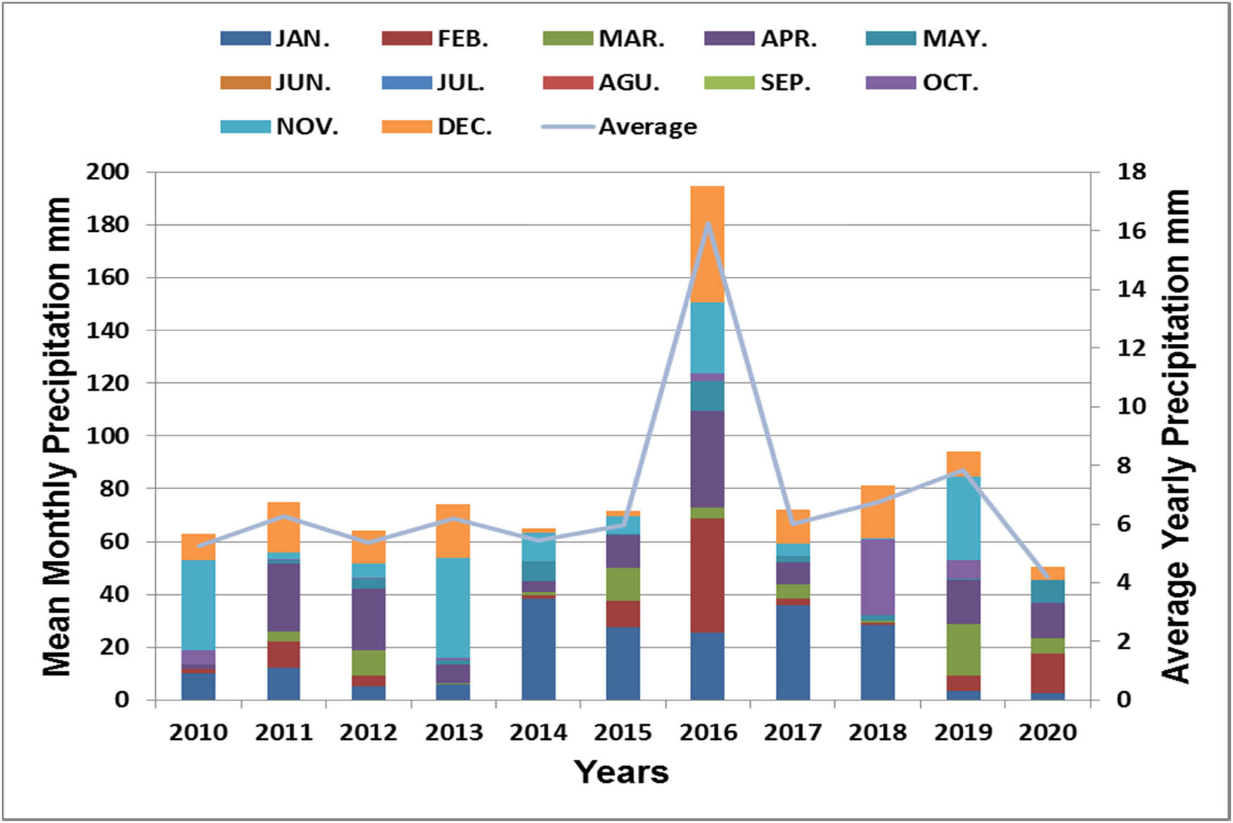
Average precipitation values per month and year over the period 2010–2020.
5 Methodology and SDSM description
Climate changes are characterized by many imperceptible fluctuations on the temporal and spatial scale, which makes the outputs of future forecasting processes inaccurate or relatively low-accurate, which is reflected in the lack of reliable hydrological estimates that can be relied upon to know climate change. General circulation models (GCMs) have the ability to predict changes in the earth’s atmosphere, allowing future events to be predicted on a large scale and with high accuracy. GCMs to be applied require the provision of a series of reliable daily data (such as temperatures and precipitation) so that the temporal and spatial predictive outputs can represent the future climate events to a reliable extent. In addition, GCMs address the problem of gaps in missing data on the spatial and temporal scale by linking the previously measured data with the subsequent and thus knowing the statistical values with acceptable accuracy [30,31,32]. To implement GCMs, the SDSM tool can be used, which is a tool that possesses high efficiency and accuracy, to create a statistical model (statistical relationship) between locally measured (predictand) climate data and those measured data on a large scale under different and fluctuating climatic conditions (predictors) that can be adapted to calibrate the data. By relying on the outputs of the GCMs extracted from the measured climate data on a large scale and before its introduction into the SDSM tool, the statistical relationship of the SDSMs can be calibrated in order to verify the accuracy of the results for future climate events expected to occur [33]. SDSM builds/creates SDSMs according to the spatial location in which the study area is located, which depends on 26 predictors as reported by the Canadian Climate Scenario Center, which depends on the spatial coordinates and climatic changes of the sites on the surface of the earth, which fall into three groups: CanESM2_rcp2.6, CanESM2_rcp4.5, and CanESM2_rcp8.5 [34,35]. In the current research, the working methodology will be as follows:
Establishing a SDSM of the observed precipitation in Al-Najaf Governorate for the period 2010–2020 by analyzing the climatic and spatial correlation of these data in order to know the appropriate statistical relationship that corresponds to the area of study. The National Centers for Environmental Prediction approved by the National Oceanic and Atmospheric Administration [36] of 26 predictors will be used.
Determining the predictors that provide the least difference between the measured and future climate precipitation values, with the aim of minimizing the size of the difference and dispersion in future data, provided that the selected predictors have the highest correlation coefficient.
The SDSM prepared using the SDSM tool of precipitation requires calibration to ensure the correctness and accuracy of the results that it will provide. The SDSM tool provides optimization algorithms that can calibrate future predictions with a set of spatial and temporal variables. The spatial and temporal variables depend on multiple regression equations that have the ability to manipulate the input parameters with the extracted ones, thus raising the independence of the resulting data and reducing potential differences, which results in enhanced prediction accuracy for future events.
Using the calibrated SDSM to predict the short-term future precipitations’ events for the years 2022, 2024, 2026, and 2028, in addition to extracting the rainfalls for the years 2010–2020 from the SDSM program.
Future values of precipitations are converted into water volumes by relying on the surface areas of Al-Kufa and Al-Abbasiya Rivers and their branches (which form the Euphrates River in the study area), which will provide an insight into the quantities of flowrates likely to occur in the near future and a study of whether these volumes of water will lead to the occurrence of flooding events in Al-Najaf Governorate or not.
6 Results and discussions
6.1 Short-term SDSM precipitation prediction and model calibration
The global climate in recent decades has been affected by many extreme weather events, which have negatively affected the processes of predicting potential future climate changes. Future prediction is one of the complex processes that require many accurate parameters with no gaps, which causes a lack of information and thus a decrease in the efficiency of the models prepared for prediction and a loss of confidence in the extracted results. For the purpose of forecasting the hydrological and climatic factors related to precipitation in Al-Najaf Governorate in the short-term state for the years 2022, 2024, 2026, and 2028, a SDSM is built using the latest version of the SDSM tool, based on historical rainfall data collected from official government sources for the period from 2010 to 2020. The model relies on the daily rainfall data, which is checked whether there are any missing or extreme values in order to ensure the correctness of the information entered into the Al-Najaf weather model. Samadi et al. [26] prepared two models, one using SDSM and the other using ANN, in order to compare the results and show the accuracy of the methods used in the prediction process. Temperature and precipitation rates were the mainstay of mathematical models to obtain a future prediction, and this resulted in a discrepancy in the expected future events resulting from each model. SDSM tool is used in the current research to predict the potential future flowrate accumulated only from the precipitation without referring to the total amount of water running in the Euphrates river, which necessitated the absence of the need for temperature data. This made the variance in the results depends mainly on the intensity of the rainfall in terms of its intensity or its decline. The scenario that is used in the data analysis process is CanESM2_rcp8.5, after excluding the scenarios CanESM2_rcp2.6 and CanESM2_rcp4.5 due to their extreme results as compared to the field observations, where the predictors of the excluded scenarios gave parameters that do not approach zero, indicating a gap between the predicted and field values. The manual calibration methodology is used in the current research, which depends on monitoring the estimated values by the model and the field-measured values in the study area in order to obtain the optimal performance of the model in predicting future hydrological events. The data collected are divided into two parts: the first is from 2010 to 2016 for the purpose of calibrating the model and the second is from 2017 to 2020 for the purpose of verifying the results of the prepared model. As the model is prepared to predict future precipitation events, it is therefore conditional on the fourth root, which aims to achieve high accuracy in the extracted results. The CanESM2_rcp8.5 scenario that is used to build the model contains 26 predictors, where these predictors are applied to the model through the calibration process, and only the predictors nceps850gl (specific humidity at 850 hpa) and ncepshumgl (near surface specific humidity) have achieved the best results when calibrating the model. Figure 6 shows the residuals of the calibrated model’s data.

Residuals of predictors for Al-Najaf precipitation modeled data over the period from 2010 to 2020.
Figure 7 indicates the results of the hydrological model that is designed/created to predict the future precipitation events in the Al-Najaf Governorate. The short-term monthly rates of precipitation are predicted for the years 2022, 2024, 2026, and 2028. In general, expectations indicate the occurrence of waves of precipitation in Al-Najaf Governorate biennially in the Autumn season, which begins in October and ends in December, and also in the Winter season from January to March. Precipitation will record its highest values in December for the years 2022, 2024, 2026, and 2028 at rates ranging 15–21 mm, while January and November rates will be recorded slightly less, ranging 9–17 mm, followed by October with rates ranging 5–8 mm. The month of March will record the lowest values of precipitation 2–3.5 mm biennially. The spring and summer months (April–September) will record null precipitation rates as this situation is normal and expected, given that the region is internationally classified as a dry region with high temperatures and the rates of rainfall in these months recede to zero.

Predicted precipitation at the short-term stage for the years 2022, 2024, 2026, and 2028.
6.2 Short-term flowrate prediction of the Euphrates river
The results obtained from the current research have not indicated the occurrence of surface runoff events as a result of future rainfall incidents, while Zhu et al. [34] did indicate the occurrence of surface runoff in varying amounts in some stations on the Biliu river basin (Liaoning province, Northeast China), although both studied sites are arid or semi-arid areas. The reason for the results’ variance is the disparity in the intensity of rainfall in both regions. The Euphrates river in Iraq has suffered from many climatic problems that have led to the drying of many of its branches due to the lack of sufficient flows in the main course of the Euphrates river to enable it to supply the distant bifurcations with water to ensure not to dry. In the governorate of Al-Najaf, the Euphrates river in its two main branches (Al-Kufa and Al-Abbasiya) suffers from additional pressures as a result of the increasing population and ill-considered use, which exacerbated the problem of decreasing quantities of running water in its main course and branches. Drying of the tributaries branching from the Euphrates river has lost the Al-Najaf governorate’s large agricultural areas as a result of the lack of irrigation water necessary for these agricultural lands. Xin et al. [37] have discussed the prediction of precipitation rates on the Huangfuchuan Basin without referring to the calculation of the quantities of flowrates. The current study has adopted the same mechanism and updated the strategy to estimate the quantities of flowrates likely to be exposed on the Euphrates river and their impact in terms of climate and usage. After identifying the future values of the precipitation for the years 2022, 2024, 2026, and 2028, it became possible to extract future quantities of water that will be received by the Euphrates river. Since the surface areas of Al-Kufa and Al-Abbasiya rivers and their branches are known, this leads to the possibility of calculating the total quantities of water, noting that the surface area of the Al-Kufa river is much larger than the Al-Abbasiya river. Figure 8 shows future quantities of flowrates for Al-Kufa and Al-Abbasiya rivers that are manually calculated biennially for each month. Figure 8 shows that the months from April to September for the future years will not add any quantities of water to Al-Kufa and Al-Abbasiya rivers coming from the precipitation due to the lack of rainfall in those months. It is expected that the Al-Kufa river will receive the largest amount of water in December of the year 2026, reaching 330,000 m3, while the lowest amount will be in October of the next year 2022, reaching approximately 80,000 m3. In the future years, Al-Kufa river will receive quantities of water ranging from 110,000 to 270,000 m3 in January, 80,000 to 220,000 m3 in February, the quantities of water will diminish to range from 15,000 to 52,000 m3 in March. The quantities of water will begin to rise gradually to range from 80,000 to 140,000 m3 in October and will continue to rise, to range in November from 185,000 to 255,000 m3, and so on, reaching a peak in December to range from 245,000–330,000 m3. Screening Figure 8 shows that the same scenario of the Al-Kufa river will be implemented to Al-Abbasiya river, but the quantities of water added to the level of the Al-Abbasiya river will be much less than that added to the Al-Kufa river. At the same time, the maximum and minimum amounts of water that the Al-Abbasiya river will receive will be in December 135,000 m3 (year 2026) and January 120,000 m3 (year 2022), respectively. In general and through tracking Figure 8, it can be concluded that the quantities of water that Al-Abbasiya river will receive will be close to half and sometimes a third of those quantities that will be received by Al-Kufa river for the months of January, February, March, October, November, and December. In contrast, no quantities of water are added to the Al-Abbasiya river in the months from April to September.

Future predicted flowrates of Al-Kufa and Al-Abbasiya Rivers (branches of the Euphrates River) biennially.
Figure 9 shows the conclusion that the current research aims to reach, which is the total quantities of water/flowrates that will be added to the Euphrates river on the short-term biennially from 2022 to 2028 that is receiving from the expected precipitation within the borders of Al-Najaf Governorate. The maximum and minimum amount of flowrates that the Euphrates river will receive will be equal to 452,000 m3 (December 2026) and 397,000 m3 (January 2022), respectively. The Euphrates river will not receive any additional quantities of flowrates from April to September for the years from 2022 to 2028. In January, the amounts of flowrates added to the Euphrates river will range from 280,000 to 293,000 m3 (2022–2028), for February 270,000 to 308,000 m3 (2022–2028), for March 30,000 to 75,000 m3 (2022–2028), for October 110,000 to 195,000 m3 (2022–2028), for November 270,000 to 308,000 m3 (2022–2028), and for December 345,000 to 452,000 m3 (2022–2028). The total quantities of flowrates added to the Euphrates river in the year 2022 will be 1,475,072 m3; for the year 2024, it will be 1,456,037 m3; for the year 2026, it will be 1,535,945 m3, and for the year 2028, it will be 1,378,403 m3. Eventually, it is obvious that in the year 2026, the expected results, as illustrated in Figure 9 show that the flowrates of the Euphrates river obtained from rainfall will be greater than the investigated years that have been studied.

The total future predicted biennial flowrates of the Euphrates river.
7 Conclusion
Water scarcity is one of the most important issues afflicting the world in recent decades, which came suddenly as a result of the exacerbation of global warming. Iraq is located in the regions classified internationally as desert and suffers from high temperatures, which causes a rise in evaporation rates and thus the deterioration of the sources of water availability represented by the Tigris and Euphrates rivers. Global warming has a negative impact on Iraq through a decrease in the intensity of precipitation, which can help to some extent and reduce the problem of water scarcity. Therefore, the expected future rainfall intensity in the short-term every two years, 2022–2028, has been studied in the current research with the aim of estimating the quantities of water/flowrates that will be received by the Euphrates river specifically, which passes through the eastern side of the study area (Al-Najaf Governorate). The Euphrates river bifurcates its main corridor within the borders of Al-Najaf Governorate into two rivers, Al-Kufa and Al-Abbasiya, with a total surface area for each of them, with their branches estimated at 16,036,750 and 6,416,200 m2, respectively. To predict future precipitation, a SDSM for the Al-Najaf Governorate is created using the SDSM tool. The statistical model has calibrated using the scenario CanESM2_rcp8.5 through the predictors nceps850gl (specific humidity at 850 hpa) and ncepshum-gl (near surface specific humidity), and the results were good and reliable. The results showed that the rates of rainfalls in Al-Najaf will be close to zero in the coming years, 2022–2028, from April to September, while the months that will witness some quantities of rainfalls will only be January, February, March, October, November, and December, with varying precipitation rates, where the maximum of which is 20 mm (December 2026) and the lowest is 2 mm (March 2026). Through relying on the results of future predicted precipitation and the available total surface area of the Euphrates river, which consists of the Al-Kufa and Al-Abbasiya rivers, the additional flowrates to the Euphrates river are calculated from the future estimated precipitation. The results showed that Al-Kufa river will receive a total flowrate of 1,053,552 m3 (2022), 1,039,956 m3 (2024), 1,097,030 m3 (2026), and 984,507 m3 (2028). While the Al-Abbasiya river will receive a total of additional flowrate from the precipitation estimated at 421,519 m3 (2022), 416,079 m3 (2024), 438,914 m3 (2026), and 393,895 m3 (2028). In conclusion, the total flowrate that will be added to the Euphrates river will be estimated at 1,475,072 m3 (2022), 1,456,037 m3 (2024), 1,535,945 m3 (2026), and 1,378,403 m3 (2028).
-
Conflict of interest: Authors state no conflict of interest.
References
[1] Khan MS, Coulibaly P, Dibike Y. Uncertainty analysis of statistical downscaling methods. J Hydrol. 2006;319(1–4):357–82.10.1016/j.jhydrol.2005.06.035Search in Google Scholar
[2] Salameh T, Drobinski P, Vrac M, Naveau P. Statistical downscaling of near surface wind over complex terrain in southern France. Meteorol Atmos Phys. 2009;103:253–65.10.1007/s00703-008-0330-7Search in Google Scholar
[3] McMichael AJ. Global climate change and health: An old story writ large. Geneva: World Health Organization; 2003.Search in Google Scholar
[4] Sahney S, Benton MJ, Ferry PA. Links between global taxonomic diversity, ecological diversity and the expansion of vertebrates on land. Biol Lett J. 2010;6(4):544–7.10.1098/rsbl.2009.1024Search in Google Scholar
[5] McMichael AJ, Woodruff RE, Hales S. Climate change and human health: Present and future risks. Lancet. 2006;367:859–69.10.1016/S0140-6736(06)68079-3Search in Google Scholar
[6] Arheimer B, Wittgren HB. Modelling the effects of wetlands on regional nitrogen transport. Ambio. 1994;23:378–86.Search in Google Scholar
[7] Eckhardt K, Fohrer N, Frede HG. Automatic Model Calibration. Hydrological Process. 2005;19(3):651–8.10.1002/hyp.5613Search in Google Scholar
[8] Thompson JR, Crawley A, Kingston DG. Future river flows and flood extent in the Upper Niger and Inner Niger Delta: GCM-related uncertainty using the CMIP5 ensemble. Hydrological Sci J. 2017;62(14):2239–65.10.1080/02626667.2017.1383608Search in Google Scholar
[9] Habets F, Boone A, Champeaux JL, Etchevers P, Franchistéguy L, Leblois E, et al. The SAFRAN-ISBA-MODCOU hydrometeorological model applied over France. J Geophys Res. 2008;113(D6):1–18.10.1029/2007JD008548Search in Google Scholar
[10] Dibike YB, Coulibaly P. Temporal neural networks for downscaling climate variability and extremes. Neural Netw. 2006;19:135–44.10.1109/IJCNN.2005.1556124Search in Google Scholar
[11] Semenov MA. Developing of high-resolution UKCUP02-based climate change scenarios in the UK. Agr For Meteorol. 2007;144:127–38.10.1016/j.agrformet.2007.02.003Search in Google Scholar
[12] Hoomehr S, Schwartz JS, Yoder DC. Potential changes in rainfall erosivity under GCM climate change scenarios for the southern Appalachian region, USA. Catena. 2016;136:141–51.10.1016/j.catena.2015.01.012Search in Google Scholar
[13] Lenderink G, Buishand A, Deursen WV. Estimates of future discharges of the river Rhine using two scenario methodologies: Direct versus delta approach. Hydrol Earth Syst Sci. 2007;11:1145–59.10.5194/hess-11-1145-2007Search in Google Scholar
[14] Ghosh S, Mujumdar PP. Statistical downscaling of GCM simulations to streamflow using relevance vector machine. Adv Water Resour. 2008;31:132–46.10.1016/j.advwatres.2007.07.005Search in Google Scholar
[15] Teng J, Vaze J, Chiew FHS, Wang B, Perraud JM. Estimating the relative uncertainties sourced from GCMs and hydrological models in modeling climate change impact on runoff. J Hydrometeorol. 2012;13:122–39.10.1175/JHM-D-11-058.1Search in Google Scholar
[16] Tabor K, Williams JW. Globally downscaled climate projections for assessing the conservation impacts of climate change. Ecol Appl. 2010;20:554–65.10.1890/09-0173.1Search in Google Scholar
[17] Moradkhani H, Meier M. Long-lead water supply forecast using large-scale climate predictors and independent component analysis. J Hydrol Eng. 2010;15:19.10.1061/(ASCE)HE.1943-5584.0000246Search in Google Scholar
[18] Chen H, Xu CY, Guo S. Comparison and evaluation of multiple GCMs, statistical downscaling and hydrological models in the study of climate change impacts on runoff. J Hydrol. 2012;434–435:36–45.10.1016/j.jhydrol.2012.02.040Search in Google Scholar
[19] Mondal A, Khare D, Kundu S, Meena PK, Mishra PK, Shukla R. Impact of climate change on future soil erosion in different slope, land use, and soil-type conditions in a part of the Narmada River Basin, India. J Hydrol Eng. 2015;20(6):1–12.10.1061/(ASCE)HE.1943-5584.0001065Search in Google Scholar
[20] Singh CR, Thompson JR, Kingston DG, French JR. Modelling water-level options for ecosystem services and assessment of climate change: Loktak Lake, northeast India. Hydrological Sci J. 2011;56:1518–42.10.1080/02626667.2011.631012Search in Google Scholar
[21] Quintana-Seguì P, Habets F, Martin E. Comparison of past and future Mediterranean high and low extremes of precipitation and river flow projected using different statistical downscaling methods. Nat Hazards Earth Syst Sci. 2011;11(5):1411–32.10.5194/nhess-11-1411-2011Search in Google Scholar
[22] Samadi SZ, Gummeneni S, Tajiki M. Comparison of general circulation models: methodology for selecting the best Gcm in Kermanshah synoptic station. Iran Int J Glob Warm. 2010;2:347–65.10.1504/IJGW.2010.037590Search in Google Scholar
[23] Quintana-Seguì P, Ribes A, Martin E, Habets F, Boé J. Comparison of three downscaling methods in simulating the impact of climate change on the hydrology of Mediterranean basins. J Hydrol. 2010;383(1–2):111–24.10.1016/j.jhydrol.2009.09.050Search in Google Scholar
[24] MOWR (Ministry of Water Resources). Water crisis reasons. Ministry of Water Resources. Al-Rafidain J. 2018. un-published.Search in Google Scholar
[25] Al-Rawdha Al-Haidarya Library in Al-Najaf, Iraq. The Euphrates River with its branches; 2021. [online]. https://www.haydarya.com/ [Accessed 15 March 2021].Search in Google Scholar
[26] Samadi S, Carbone GJ, Mahdavi M, Sharifi F, Bihamta MR. Statistical downscaling of climate data to estimate streamflow in a semi-arid catchment. Hydrol Earth Syst Sci Discuss. 2012;9:4869–4918.10.5194/hessd-9-4869-2012Search in Google Scholar
[27] Salehnia N, Hosseini F, Farid A, Kolsoumi S, Zarrin A, Hasheminia M. Comparing the performance of dynamical and statistical downscaling on historical run precipitation data over a semi-arid region. Asia Pac J Atmos Sci. 2019;55:737–49.10.1007/s13143-019-00112-1Search in Google Scholar
[28] Chen J, Gitau MW, Engel BA, Flanagan DC. Suitability of CLIGEN precipitation estimates based on a n updated database and their impacts on urban runoff:aA case study of the Great Lakes Region, USA. Hydrol Sci J. 2018;63:1502–18.10.1080/02626667.2018.1513655Search in Google Scholar
[29] Wang X, Yang T, Li X, Shi P, Zhou X. Spatio-temporal changes of precipitation and temperature over the Pearl River basin based on CMIP5 multi-model ensemble. Stoch Env Res Risk Assess. 2017;3:1077–89.10.1007/s00477-016-1286-7Search in Google Scholar
[30] Chang JX, Zhang HX, Wang YM, Zhang LP. Impact of climate change on runoff and uncertainty analysis. Nat Hazards. 2017;88:1113–31.10.1007/s11069-017-2909-0Search in Google Scholar
[31] Guo DL, Sun JQ, Yu ET. Evaluation of CORDEX regional climate models in simulating temperature and precipitation over the Tibetan Plateau. Atmos Ocean Sci Lett. 2018;11:219–27.10.1080/16742834.2018.1451725Search in Google Scholar
[32] Rajib A, Merwade V, Yu ZQ. Rationale and efficacy of assimilating remotely sensed potential evapotranspiration for reduced uncertainty of hydrologic models. Water Resour Res. 2018;54:4615–37.10.1029/2017WR021147Search in Google Scholar
[33] Najafi R, Kermani MRH. Uncertainty modeling of statistical downscaling to assess climate change impacts on temperature and precipitation. Water Resour Manag. 2017;31:1843–58.10.1007/s11269-017-1615-8Search in Google Scholar
[34] Zhu XP, Zhang C, Qi W, Cai WJ, Zhao XH, Wang XN. Multiple climate change scenarios and runoff response in Biliu River. Water. 2018;10:126.10.3390/w10020126Search in Google Scholar
[35] Du XZ, Shrestha NK, Wang J. Assessing climate change impacts on stream temperature in the Athabasca River Basin using SWAT equilibrium temperature model and its potential impacts on stream ecosystem. Sci Total Env. 2019;650:1872–81.10.1016/j.scitotenv.2018.09.344Search in Google Scholar PubMed
[36] Noaa US. National Oceanic and Atmospheric Administration; 2009.Search in Google Scholar
[37] Xin S, Weiwei S, Jiahong L, Yunzhong J. Multi-Site statistical downscaling method using GCM-based monthly data for daily precipitation generation. Water. 2020;12(904):1–21.10.3390/w12030904Search in Google Scholar
© 2022 Hayder H. Kareem and Aseel A. Alkatib, published by De Gruyter
This work is licensed under the Creative Commons Attribution 4.0 International License.
Articles in the same Issue
- Regular Articles
- Performance of a horizontal well in a bounded anisotropic reservoir: Part I: Mathematical analysis
- Key competences for Transport 4.0 – Educators’ and Practitioners’ opinions
- COVID-19 lockdown impact on CERN seismic station ambient noise levels
- Constraint evaluation and effects on selected fracture parameters for single-edge notched beam under four-point bending
- Minimizing form errors in additive manufacturing with part build orientation: An optimization method for continuous solution spaces
- The method of selecting adaptive devices for the needs of drivers with disabilities
- Control logic algorithm to create gaps for mixed traffic: A comprehensive evaluation
- Numerical prediction of cavitation phenomena on marine vessel: Effect of the water environment profile on the propulsion performance
- Boundary element analysis of rotating functionally graded anisotropic fiber-reinforced magneto-thermoelastic composites
- Effect of heat-treatment processes and high temperature variation of acid-chloride media on the corrosion resistance of B265 (Ti–6Al–4V) titanium alloy in acid-chloride solution
- Influence of selected physical parameters on vibroinsulation of base-exited vibratory conveyors
- System and eco-material design based on slow-release ferrate(vi) combined with ultrasound for ballast water treatment
- Experimental investigations on transmission of whole body vibration to the wheelchair user's body
- Determination of accident scenarios via freely available accident databases
- Elastic–plastic analysis of the plane strain under combined thermal and pressure loads with a new technique in the finite element method
- Design and development of the application monitoring the use of server resources for server maintenance
- The LBC-3 lightweight encryption algorithm
- Impact of the COVID-19 pandemic on road traffic accident forecasting in Poland and Slovakia
- Development and implementation of disaster recovery plan in stock exchange industry in Indonesia
- Pre-determination of prediction of yield-line pattern of slabs using Voronoi diagrams
- Urban air mobility and flying cars: Overview, examples, prospects, drawbacks, and solutions
- Stadiums based on curvilinear geometry: Approximation of the ellipsoid offset surface
- Driftwood blocking sensitivity on sluice gate flow
- Solar PV power forecasting at Yarmouk University using machine learning techniques
- 3D FE modeling of cable-stayed bridge according to ICE code
- Review Articles
- Partial discharge calibrator of a cavity inside high-voltage insulator
- Health issues using 5G frequencies from an engineering perspective: Current review
- Modern structures of military logistic bridges
- Retraction
- Retraction note: COVID-19 lockdown impact on CERN seismic station ambient noise levels
- Special Issue: Trends in Logistics and Production for the 21st Century - Part II
- Solving transportation externalities, economic approaches, and their risks
- Demand forecast for parking spaces and parking areas in Olomouc
- Rescue of persons in traffic accidents on roads
- Special Issue: ICRTEEC - 2021 - Part II
- Switching transient analysis for low voltage distribution cable
- Frequency amelioration of an interconnected microgrid system
- Wireless power transfer topology analysis for inkjet-printed coil
- Analysis and control strategy of standalone PV system with various reference frames
- Special Issue: AESMT
- Study of emitted gases from incinerator of Al-Sadr hospital in Najaf city
- Experimentally investigating comparison between the behavior of fibrous concrete slabs with steel stiffeners and reinforced concrete slabs under dynamic–static loads
- ANN-based model to predict groundwater salinity: A case study of West Najaf–Kerbala region
- Future short-term estimation of flowrate of the Euphrates river catchment located in Al-Najaf Governorate, Iraq through using weather data and statistical downscaling model
- Utilization of ANN technique to estimate the discharge coefficient for trapezoidal weir-gate
- Experimental study to enhance the productivity of single-slope single-basin solar still
- An empirical formula development to predict suspended sediment load for Khour Al-Zubair port, South of Iraq
- A model for variation with time of flexiblepavement temperature
- Analytical and numerical investigation of free vibration for stepped beam with different materials
- Identifying the reasons for the prolongation of school construction projects in Najaf
- Spatial mixture modeling for analyzing a rainfall pattern: A case study in Ireland
- Flow parameters effect on water hammer stability in hydraulic system by using state-space method
- Experimental study of the behaviour and failure modes of tapered castellated steel beams
- Water hammer phenomenon in pumping stations: A stability investigation based on root locus
- Mechanical properties and freeze-thaw resistance of lightweight aggregate concrete using artificial clay aggregate
- Compatibility between delay functions and highway capacity manual on Iraqi highways
- The effect of expanded polystyrene beads (EPS) on the physical and mechanical properties of aerated concrete
- The effect of cutoff angle on the head pressure underneath dams constructed on soils having rectangular void
- An experimental study on vibration isolation by open and in-filled trenches
- Designing a 3D virtual test platform for evaluating prosthetic knee joint performance during the walking cycle
- Special Issue: AESMT-2 - Part I
- Optimization process of resistance spot welding for high-strength low-alloy steel using Taguchi method
- Cyclic performance of moment connections with reduced beam sections using different cut-flange profiles
- Time overruns in the construction projects in Iraq: Case study on investigating and analyzing the root causes
- Contribution of lift-to-drag ratio on power coefficient of HAWT blade for different cross-sections
- Geotechnical correlations of soil properties in Hilla City – Iraq
- Improve the performance of solar thermal collectors by varying the concentration and nanoparticles diameter of silicon dioxide
- Enhancement of evaporative cooling system in a green-house by geothermal energy
- Destructive and nondestructive tests formulation for concrete containing polyolefin fibers
- Quantify distribution of topsoil erodibility factor for watersheds that feed the Al-Shewicha trough – Iraq using GIS
- Seamless geospatial data methodology for topographic map: A case study on Baghdad
- Mechanical properties investigation of composite FGM fabricated from Al/Zn
- Causes of change orders in the cycle of construction project: A case study in Al-Najaf province
- Optimum hydraulic investigation of pipe aqueduct by MATLAB software and Newton–Raphson method
- Numerical analysis of high-strength reinforcing steel with conventional strength in reinforced concrete beams under monotonic loading
- Deriving rainfall intensity–duration–frequency (IDF) curves and testing the best distribution using EasyFit software 5.5 for Kut city, Iraq
- Designing of a dual-functional XOR block in QCA technology
- Producing low-cost self-consolidation concrete using sustainable material
- Performance of the anaerobic baffled reactor for primary treatment of rural domestic wastewater in Iraq
- Enhancement isolation antenna to multi-port for wireless communication
- A comparative study of different coagulants used in treatment of turbid water
- Field tests of grouted ground anchors in the sandy soil of Najaf, Iraq
- New methodology to reduce power by using smart street lighting system
- Optimization of the synergistic effect of micro silica and fly ash on the behavior of concrete using response surface method
- Ergodic capacity of correlated multiple-input–multiple-output channel with impact of transmitter impairments
- Numerical studies of the simultaneous development of forced convective laminar flow with heat transfer inside a microtube at a uniform temperature
- Enhancement of heat transfer from solar thermal collector using nanofluid
- Improvement of permeable asphalt pavement by adding crumb rubber waste
- Study the effect of adding zirconia particles to nickel–phosphorus electroless coatings as product innovation on stainless steel substrate
- Waste aggregate concrete properties using waste tiles as coarse aggregate and modified with PC superplasticizer
- CuO–Cu/water hybrid nonofluid potentials in impingement jet
- Satellite vibration effects on communication quality of OISN system
- Special Issue: Annual Engineering and Vocational Education Conference - Part III
- Mechanical and thermal properties of recycled high-density polyethylene/bamboo with different fiber loadings
- Special Issue: Advanced Energy Storage
- Cu-foil modification for anode-free lithium-ion battery from electronic cable waste
- Review of various sulfide electrolyte types for solid-state lithium-ion batteries
- Optimization type of filler on electrochemical and thermal properties of gel polymer electrolytes membranes for safety lithium-ion batteries
- Pr-doped BiFeO3 thin films growth on quartz using chemical solution deposition
- An environmentally friendly hydrometallurgy process for the recovery and reuse of metals from spent lithium-ion batteries, using organic acid
- Production of nickel-rich LiNi0.89Co0.08Al0.03O2 cathode material for high capacity NCA/graphite secondary battery fabrication
- Special Issue: Sustainable Materials Production and Processes
- Corrosion polarization and passivation behavior of selected stainless steel alloys and Ti6Al4V titanium in elevated temperature acid-chloride electrolytes
- Special Issue: Modern Scientific Problems in Civil Engineering - Part II
- The modelling of railway subgrade strengthening foundation on weak soils
- Special Issue: Automation in Finland 2021 - Part II
- Manufacturing operations as services by robots with skills
- Foundations and case studies on the scalable intelligence in AIoT domains
- Safety risk sources of autonomous mobile machines
- Special Issue: 49th KKBN - Part I
- Residual magnetic field as a source of information about steel wire rope technical condition
- Monitoring the boundary of an adhesive coating to a steel substrate with an ultrasonic Rayleigh wave
- Detection of early stage of ductile and fatigue damage presented in Inconel 718 alloy using instrumented indentation technique
- Identification and characterization of the grinding burns by eddy current method
- Special Issue: ICIMECE 2020 - Part II
- Selection of MR damper model suitable for SMC applied to semi-active suspension system by using similarity measures