
Geological characteristics and prospecting direction of Sanjiaoding gold mine in Saishiteng area
-
Changyun Liu
 ,
Youwen Ma
,
Youwen Ma

Abstract
This article studies the geological characteristics analysis and prospecting direction of the triangle top gold mine in the Saishiteng area, so as to realize accurate and massive gold mining in this area in the future. Taking the triangle top area of Saishiteng area located in the northern margin of Qaidam Basin from Saishiteng Mountain to Tanjianshan Mountain as the research object, the technical route of combining field investigation with indoor comprehensive research is adopted, and the observation of field geological characteristics is emphasized, and the geophysical characteristics are analyzed, and finally the characteristics of regional geological structure are obtained. The controlled source audio-frequency magnetotelluric method is used in combination with geological characteristics, and the distribution of gold deposits in the study area is determined by calculating and detecting electromagnetic anomalies, and the prospecting direction of gold deposits is clear. The test results show that the stratum structure in the study area is rich, the folds and faults are very complex, the primary colors of metals are distributed in all strata, and the elements of Au are more distributed. According to the results of electromagnetic analysis, there are magnetic anomalies in M15 and M18-1 areas, and these two prospecting target areas are clearly identified through detection.
1 Introduction
Mineral resources play an important role in China’s national construction. At present, mineral resources provide about 95% energy and more than 70% agricultural means of production in China. This shows that there is no sustainable development of national economy without the continuous supply of mineral resources. However, China’s mining production and development have also encountered unprecedented crises and challenges at this stage, mainly manifested in: zero reserves of mineral resources, poor quality of mineral data, and gradual depletion of mineral data, which have an important impact on national economic and social stability [1]. In order to solve these problems, besides relying on technological innovation, it is imperative to further increase exploration and storage. The triangle top gold mine in Saishiteng area is located in Dachaidan Town, Qinghai Province, which is a mineral concentration area with great resource potential and prospecting prospect discovered in the 1990s. The Dushugou gold mine, which has been proven in this area, is located in the southeast of Jinlonggou gold mine and in the northeast of Qinglonggou gold mine, which is one of the gold mines with the greatest prospecting potential in Tanjianshan gold mine [2]. Through the prospecting work in recent years, good prospecting results have been achieved. According to the 1:10,000 rock survey primary halo anomaly, many mineralization information points have been found in the periphery of Jinlonggou mining area, and 16 gold bodies have been found in Dushugou HS11 anomaly area, with an estimated gold resource of 1.28 tons [3]. The project “Study on gold mineralization model and optimization of target area in Saishiteng area, Qinghai Province” that is being investigated in this article is a new high-level talent training project assigned to Qinghai Geological Survey Institute according to the document “Notice of Qinghai Provincial Bureau of Geology and Mineral Exploration and Development on Issuing the first batch of geological exploration projects in 2022” (No.32 [2022] of Qingdi Mining Department). First, the goal of this project is mainly to study the law of gold enrichment in Xitinggou, triangle top north, and other typical mining areas, initially establish a metallogenic model, guide the deployment of prospecting exploration, and strive to achieve a breakthrough in prospecting [4,5,6]. Second, on the basis of systematic collection of existing research results, the peripheral gold spots such as HongLiu Quan North are selected to carry out research on mineralization enrichment mechanism, comprehensively sort out the metallogenic regularity of gold deposits in Saishiteng area, and preliminarily summarize the coupling relationship between mineralization enrichment and geological events. Finally, further improve the regional metallogenic model, carry out metallogenic prediction, and optimize 1–2 prospecting targets.
Due to the epidemic situation, the field investigation from September to November arranged in 2022 was not carried out smoothly, and the annual workload was not fully completed. Some samples were too few and not representative, which affected the comprehensive improvement of the results. However, it is uncertain whether the gold-bearing minerals in Sanjiaoding and Xidinggou mining areas are pyrite, and there is no exact experimental data to support them. In the field investigation, different stages and forms of pyrite have been found, and these problems need further study and solution. At the same time, in order to realize accurate gold mining in Sanjiaoding gold mine in Saishiteng area, in this article, the geological characteristics of triangle top gold mine area in Saishiteng area are analyzed through practical investigation, and the distribution of underground gold mines in triangle top gold mine area is determined by a controlled source audio-frequency magnetotelluric method, which makes the next prospecting direction clear. The innovations of this article are as follows:
This article takes the Sanjiaoding area in Saishiteng area between Saishiteng Mountain and Tanjian Mountain in the northern margin of Qaidam Basin as the research object, adopts the technical route of combining field investigation with indoor comprehensive research, pays attention to the observation of field geological characteristics, analyzes geophysical characteristics, and finally obtains the regional geological structure characteristics.
Combined with the geological characteristics, the controlled source audio-frequency magnetotelluric method is used to determine the distribution of gold deposits in the study area and the prospecting direction of gold deposits by calculating and detecting electromagnetic anomalies.
The stratum structure in the study area is rich, and the folds and faults are very complicated. The primary colors of metals are distributed in all strata, and Au elements are more widely distributed.
According to the results of electromagnetic analysis, there are magnetic anomalies in M15 and M18-1 areas, and these two prospecting targets are identified through exploration.
2 Literature review
Many scholars have done research on the regional geological characteristics of gold deposits and the determination of prospecting direction. Berezovsky et al. have proposed to take a certain place in Ukraine as the research object, determine the cause of gold mining and mineralization from the perspective of hydrothermal mineral assemblage, and analyze various mixed substances, trace elements, and toxic substances mixed in gold deposits with various instruments and equipment to determine the geological characteristics and mineral distribution of the research area in detail [7]. Aguilar et al. take the Atacama Desert as the research object and analyze the sediments in the gold mining area and the composition of waste after gold mining under the influence of flash floods. By analyzing the contents of various substances in these soils, the geological state of the research area is determined, and at the same time, the distribution of gold mines is clear, which is convenient for future prospecting and mining [8]. Vazelhes et al. tried to show the nature of glacial sediments and its influence on gold mining in northern Canada, defined and explained the geometric shape of the diffusion sequence of mineralized debris by using geochemical elegant exploration data set and Quaternary map, determined the environment around the underground gold mine and trace elements, and pointed out a new direction for gold mining [9]. An et al. proposed the superposition characteristics of primary halo and its prospecting significance in Daping gold deposit, Yunnan Province, and studied the primary halo and elements related to mineralization in Daping gold deposit by using multi-element rock geochemical data. The correlation coefficient matrix is used to study the correlation between elements in samples with gold grade greater than 1 ppm, and the results are used to study the element combination of the deposit. Secondly, the axial zonality sequence of indicator elements is calculated by the Gregory method. Then, according to the content of 18 elements in 11 middle sections, the axial change of indicator elements is studied. Finally, according to the concentration zoning of elements and the axial change of indicator elements, four deep target areas are determined. The validity of this research method is proven. The research results of this article provide an example for the application of primary halo superposition characteristics in deep prospecting of similar gold mineralization in other areas [10]. Daneshvar et al. put forward the explanation of the hydrothermal evolution of qolqoleh gold deposit in southwest Sakez, Iran, which is located in the north of Sanandaj-Sirjan belt in northwest Iran. The main ore-bearing rocks include mylonitized granite and chlorite schist. Four generations of Au-containing sulfides, named Py1 to Py4, have been identified. The elemental images and point analysis of Au and other trace elements in Py1 to Py4 were carried out by laser ablation inductively coupled plasma mass spectrometry to provide reliable information about ore-forming fluids and saturation conditions. The elemental composition of pyrite in all generations shows the heterogeneity of fluid composition and reflects the role of a multi-stage hydrothermal system in their formation [11]. Toubri et al. proposed to integrate 3D geological modeling and stochastic simulation to promote the upstream management of waste rock and created a stochastic process combined with borehole core geological logging to meet the precondition of 3D modeling with a known error range. The results of this work include a 3D spatial model of arsenic content across ore deposits and host rocks. Each implementation is evaluated using existing chemical analysis to emphasize the reliability of the model. The results show that the geochemical halo of arsenic extends beyond 500 m from the gold mine, and the arsenic grade of up to 94% exceeds 50 ppm [12].
3 Geological structure analysis and prospecting direction research
3.1 Overview of the study area
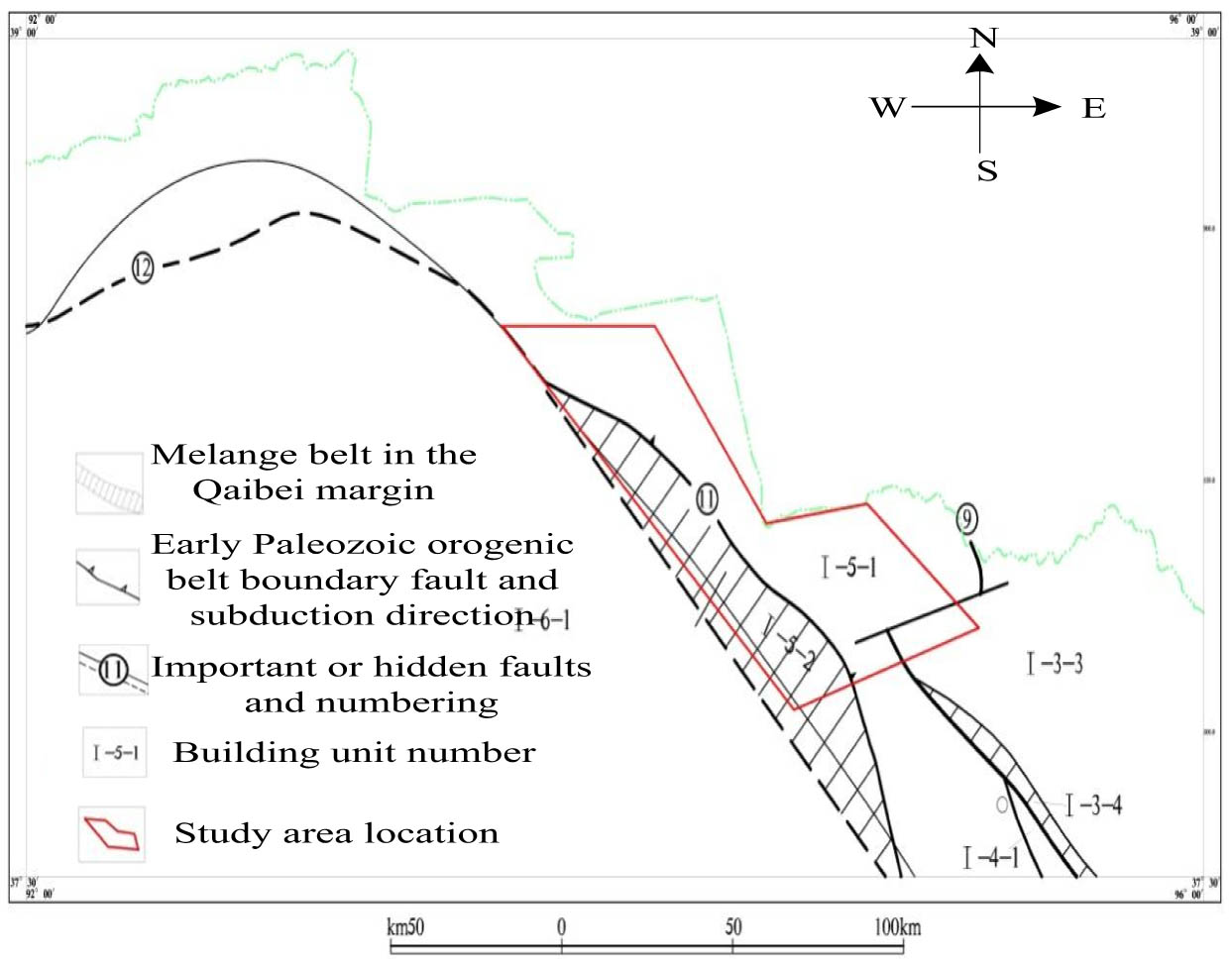
The study area is located in the Saishitengshan-Tanjianshan area on the northern margin of Qaidam Basin, with rich material composition, strong magmatic activity, complex geological structure, and superior metallogenic conditions for gold polymetallic deposits. The strata in the study area have been distributed from Proterozoic to Quaternary and generally distributed in the northwest and northwest directions. This time, stratigraphic regionalization cited the division plan of Regional Geology of Qinghai Province (2019). The strata in the area belong to the Qinqikun Stratigraphic Region, bounded by the northern Qaidam fault, the main part belongs to the East Kunlun-northern Qaidam Stratigraphic Region, and a small amount is located in the Qilian Stratigraphic Region. Now, it is divided into different stratigraphic regions from old to new. The stratum in the study area mainly belongs to the northern margin stratum area in the East Kunlun-Qaidam stratigraphic area. The study area belongs to the northern margin of Qaidam in the East Kunlun-Middle Qinling Stratigraphic Division of Qinqikun Stratigraphic Zone in North China Stratigraphic Region. The main regional strata are Proterozoic DakenDaban Group, Mesoproterozoic Wandonggou Group, and Paleozoic Ordovician-Silurian Tanjianshan Group, with Devonian, Carboniferous, Triassic, and Jurassic strata exposed sporadically, and the mountain edges and valleys are Cenozoic quaternary continental deposits.
The northeast of the study area is bounded by the Wild Camel Spring West Gold-Cobalt Deposit and Qinghai-Gansu Province boundary, and the southwest is bounded by Qinglonggou, Jinlonggou, Xijinggou, and the northern Qaidam-Xiariha fault. Geographical coordinates: 93°38′–95°15′E, 38°′–38°43′N, covering an area of 3,652 km2. The study area starts from the west of Wild Camel Spring in the west and reaches the Aolao River in the east, which spans about 60 km from east to west. The administrative divisions are under the jurisdiction of Dachaidan Administrative Committee and Mangya City of Haixi Mongolian and Tibetan Autonomous Prefecture in Qinghai Province. There is a Dun (Dunhuang)-Ge (Golmud) highway in the north. The transportation distance from its eastern part to Dachaidan is 90 km, of which the simple highway is 10 km, about 165 km from Xitieshan Railway Station of Qinghai-Tibet Railway, and about 370 km from Liuyuan Railway Station of Lanxin Railway. The transportation distance from the west section to Dachaidan is 160 km, of which the simple highway is 15 km, and it is about 310 km away from Liuyuan Railway Station of Lanzhou-Xinjiang Railway, with convenient transportation. The degree of geological and mineral work in the study area is relatively high. At present, 1:200,000 regional geological survey, regional geophysical exploration, and regional geochemical exploration have covered the whole area, and 1:50,000 geophysical and geochemical work has basically covered the whole area, and a large proportion of geological mapping work has been carried out in some mining areas. The northern margin of Qaidam basin is famous for its ultra-high-pressure metamorphic belt, and the discovery of the Tanjianshan gold ore field has attracted a large number of domestic scholars, and the overall research level is relatively high, but there are different opinions. Since the 1950s, the Qilian Mountain Geological Team of the Chinese Academy of Sciences, the regional survey teams of Gansu, Qinghai, Ningxia, and Shaanxi Geological (Mineral) Bureaus, the 632 teams of Northwest Geological Bureau, the first and fifth regional geological survey teams of Qinghai Province and the first geological and mineral exploration brigade of Qinghai Province have successively carried out route geological surveys and special surveys, 1:1 million route geological surveys, 1:200,000 regional geological surveys, 1:200,000 aerial photo geological mapping, 1:50,000 regional geological survey, and other work, accumulated rich geological data.
The study area has undergone the superposition transformation of multi-stage tectonic movements, which makes the structure in the area very complex, and the folds and faults are well developed. Tectonic movement has the characteristics of inheritance and multi-period. It obviously controls the strata, magmatic activity, metamorphism, and mineral distribution in the area. Throughout the region, faults and folds are well developed. The tectonic framework of this area is mainly composed of three groups of structures in northwest, northeast, and near east-west, and the general direction of the regional tectonic line is northwest-southeast. The main folds in the region are the Tanjianshan compound anticline structure, secondary Jinlonggou syncline, and Qinglonggou syncline. This structure is distributed in the southeast section of Saishiteng Mountain in the middle of the northern uplift belt of Qaidam, starting from Xiao Zi Shan in the northwest, Yushigou in the south east longitude, and the central mountain to Jinlonggoukou, with a strike length of about 27 km and an axial direction of 330° northwest, and the axial plane tends to northeast. It is the largest fold structure in the survey area. The Little Zi Shan in the northwest is located at the inclined end of the anticline, with a clear structural form, the core is silicified dolomitic marble, and its wings are composed of carbonaceous sericite phyllite and calcareous schist. The middle part and the south-east part of the anticline are incomplete due to the emplacement of a longer rapakivi granite body or Quaternary coverage, and its northeast wing is covered by Triassic continental rift basin. The southwest wing is well preserved and consists of two secondary synclinal structures, Qinglonggou and Jinlonggou. Qinglonggou Gold Mine and Jinlonggou Gold Mine are located in the corresponding syncline structure and controlled by it. Faults are criss-crossing, resulting in the barrier and graben structure in this area in both vertical and horizontal directions, and intermittently exposed on the surface. The division of structural units in the study area is shown in Figure 1.
Division of building units.
3.2 Geological structure analysis method
Take the technical route of combining field investigation and indoor comprehensive research, pay attention to the observation of field geological characteristics, summarize and analyze geophysical characteristics, collect existing regional geological data, etc., and summarize and analyze to obtain the comprehensive information content of the regional geological structure. The specific technical route is shown in Figure 2.
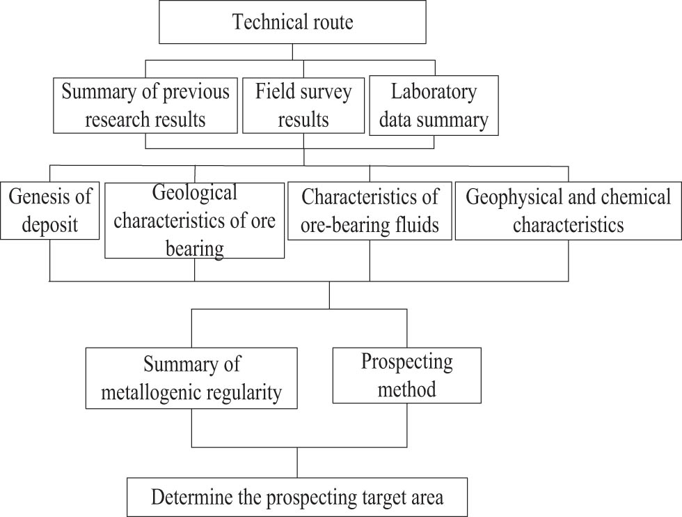
Geological structure analysis route.
The exposed bedrock in the study area is granite poplar, and the Quaternary system is widely distributed, with strong rock weathering and poor bedrock exposure. Therefore, the comprehensive prospecting method of geology and geochemical exploration is adopted to provide a deep basis for drilling construction through an actual survey. The general idea of this technical route is to first select a 1:10,000 soil geochemical survey combined with geological mapping to delineate the target area, delineate the anomalies, narrow the prospecting target area, and find the mineralization-enriched areas. The exploration trench project is used to expose the discovered ore bodies and altered forms, verify geochemical anomalies, and find out the causes of anomalies. Using drilling engineering to control abnormal areas, we can roughly find out the geological characteristics of the study area and the deep changes of ore bodies. Using 1:10,000 geological mapping and 1:10,000 soil geochemical survey sampling work [13]. According to the distribution direction of strata and structural occurrence characteristics in this area, the geochemical exploration network is arranged roughly perpendicular to the structural axis. At the same time of geochemical sampling, the geological survey of the route is carried out. The topographic map of 1:10,000 provided by the local Bureau of Surveying and Mapping is used for the base map, while the crossing method is used for the mapping, with the recourse method as the cooperation, and the interval between observation lines is within 200 m; The geological observation route is arranged perpendicular to the strike of the main structural lines, and the main fault structures, dikes and mineralized bodies are delineated by recourse method. Mineralized altered geological bodies or marker beds with a width of 2 m and an extension of more than 3 m are all enlarged on the map. According to the results of mapping and geochemical exploration, the area with great metallogenic potential is selected for geophysical IP ladder measurement. According to geological mapping and geophysical and geochemical exploration results, the representative target layout verification project is selected.
3.3 Research on prospecting direction based on the magnetotelluric survey method
3.3.1 Basic survey methods
As an important geophysical exploration technology, the magnetotelluric survey method plays an important role in the field of mineral resources exploration. This method uses the electromagnetic induction phenomenon produced by a natural alternating electromagnetic field in underground medium, infers the electrical structure of underground medium by observing the changes of ground electric field and magnetic field, and then provides the direction for prospecting. The specific steps are as follows:
Step 1: In the research of prospecting direction based on the magnetotelluric survey method, the detailed field data collection work is carried out in the research area. Comprises the steps of arranging measuring points, installing electric field and magnetic field observation instruments, recording data, and the like. In the process of data acquisition, ensure the accuracy and stability of the instrument to obtain accurate and reliable data.
Step 2: After data collection, use professional data processing software to preprocess, invert, and interpret the data.
Step 3: The preprocessing stage mainly includes data filtering, denoising, and correction to improve the data quality.
Step 4: In the inversion stage, mathematical algorithms and models are used to fit the observed data to obtain the electrical structure model of underground medium.
Step 5: In the interpretation stage, combined with geological background, geochemical characteristics, and known mineral information, the inversion results are comprehensively analyzed to determine the possible prospecting direction.
Combining the geological characteristics of the study area with CSAMT [14], this method is an electromagnetic method that can control the field source manually. In practical work, the most common use is to connect the alternating current generated by a transmitter that can change the frequency with two grounding electrodes through a certain length of wire, and supply the alternating current to the earth [15], which is commonly called a horizontal dipole source; Sometimes alternating current and an ungrounded horizontal coil can also be used as the field source, which is commonly called vertical magnetic dipole. Maxwell’s equations are used to calculate the electromagnetic field in the CSAMT method [16]. Maxwell’s equations are a set of basic and empirical equations to describe electromagnetic fields:
In the equation,
3.3.2 Calculation of the wave equation
In homogeneous medium, the variable charge density is actually equal to zero except where the field source is located [17]. So, outside the field source, equation (4) in Maxwell’s equations can be written as
In order to study the equations satisfied by electric field or magnetic field, respectively, it is necessary to eliminate the magnetic field vector or electric field vector from equations (1) and (2) and transform them into an equation containing only one vector. Therefore, the left and right ends of the equal sign of equation (1) are taken as curl:
Substitute equation (2) into (7):
By performing the same operation on equation (2), the related equation of magnetic field intensity can be obtained
Equations (8) and (9) are collectively called wave equations, which relate the changes of the appropriate space of the field with the changes with time, indicating that the electromagnetic field propagates in the underground space in the form of waves. Through the different magnetic fields reflected by the electromagnetic field in the baseline space, the mineral content and storage location in the underground space are determined, and the gold prospecting target area is determined.
3.3.3 Practical working methods
3.3.3.1 Field source
Generally, two kinds of field sources are often used: horizontal electric dipole and vertical magnetic dipole, that is, grounding conductor and grounding loop. In practical work, the signal of electric dipole is superior to the loop source, but when the grounding resistance of the electrode exceeds the shell, it is not suitable to use the electric dipole as the launch source, and the electric dipole can also control the direction of the field, so the loop source is rarely used in the field [18].
3.3.3.2 Transceiver distance
The determination of transmitting-receiving distance needs to be combined with the design detection depth, the earth resistivity in the work area, the signal-to-noise ratio of the instrument, and other factors. In general, under the premise of ensuring a certain signal-to-noise ratio, the receiving-transmitting distance should meet the remote measurement conditions as much as possible, and the design scheme is usually designed according to more than twice the maximum buried depth of the target [19].
3.3.3.3 Emitter distance
The distance length of the transmitting dipole should ensure enough signal-to-noise ratio and meet the conditions of the electric dipole as far as possible, usually according to selection and general.
3.3.3.4 Receiving polar distance
The length of the receiving dipole distance is determined according to the size of the geological target and the strength of the electric signal. Usually choose between, the general selection principle is: when the target body is large and deep, the length should be larger. Too much will reduce the resolution, while too little will reduce the observation quality [20].
3.3.3.5 Layout of field instruments
Usually, in the field work, the observation area is always arranged in a trapezoidal area as shown in the figure, and the length of the survey line should be kept within the trapezoidal area.
4 Results
4.1 Analysis of stratum structure
Detailed stratification of stratum structure is shown in Table 1.
Detailed structure of strata
| Stratigraphic region | Geologic era | Rock unit | Sub-region | Era/period | Age | Formation |
|---|---|---|---|---|---|---|
| Qinqi-kun Area | Early paleozoic | Yanchiwan | South Qilian | Ordovician | O2 | Yanchiwan Fm |
| Kunlun-Qaidam Area | Quaternary | Qiqiquan | Chaibei Margin | Middle Pleistocene | Qp1 | Qiqiquan Fm |
| — | Pliocene | Shizigou | — | Pliocene | N2 | Shizigou Fm |
| — | Miocene-Oligocene | Ganchaigou | — | Oligocene-Miocene | E3N1 | Ganchaigou Fm |
| — | Paleocene | Luluhe | — | Paleocene-Early Eocene | E1-2 | Luluhe Fm |
| — | Late Jurassic | Hongshuigou | — | Late Jurassic | J3 | Hongshuigou Fm |
| — | Early-Middle Jurassic | Dameigou | — | Early-Middle Jurassic | J1-2 | Dameigou Fm |
| — | Middle-Late Devonian | Yanniushan | — | Middle-Late Devonian | D2-3 | Yanniushan Fm |
4.1.1 East Kunlun-Qaidam stratigraphic area
The stratum in the study area mainly belongs to the northern margin stratum area in the East Kunlun-Qaidam stratum area.
4.1.1.1 Proterozoic Daken Daban Group (Pt1D)
It is distributed in the northern part of Saishiteng Mountain, Daken Dabanshan-Yuka area, and is generally distributed in a zigzag shape from northwest to southeast. It is a set of layered disordered medium-deep metamorphic rock series and one of the metamorphic crystalline basement geological bodies. It is divided into gneiss formation (Pt1D1˙) and marble formation (Pt1D2˙).
4.1.1.2 Mesoproterozoic Wandonggou Group (Pt2-32W)
The Wanxiangou Group of the Jixian-to-be-built system in the area is distributed in the Wandonggou-Tanjianshan area of Saishiteng Mountain, which is relatively developed, and the strata are fully exposed. It is controlled by the NW-trending fault and distributed in a NW-trending belt, and it is in fault contact with the Ordovician Tanjianshan Group. The Wandonggou Group is divided into lower clastic rock formation and upper carbonate rock formation.
4.1.1.3 Cambrian-Ordovician strata
Cambrian-Ordovician strata in this area include the Tanjianshan Group (OT) and ophiolite melange in the eastern Kunlun-northern margin of Qaidam basin. A small amount of Yanchiwan Formation (O2y) is exposed in the southeast of the study area.
4.1.1.4 Middle-late Devonian Yakeshan Formation (D2-3m) stratum
This set of strata belongs to the stratigraphic division of the northern margin of Qaidam, mainly distributed in the Saishiteng area. The lower part is coarse clastic rock, mainly miscellaneous sandstone; the upper part is composed of intermediate-acid volcanic rocks, mainly andesite, andesite agglomerate, and almond-shaped andesite. Volcanic rocks belong to a weak peraluminous calc-alkaline series, with the characteristics of continental eruption, and belong to the volcanic rock assemblage in a collision environment. It is a volcanic-sedimentary fault basin environment.
4.1.1.5 Jurassic strata
It consists of Dameigou Formation (J1-2dm) and Hongshuigou Formation (J3h).
4.1.1.6 Paleogene strata
The Paleogene strata in the area belong to the stratigraphic division in the northern margin of Tantan, mainly including Lulehe Formation (E1-2l), Ganchaigou Formation (E3N1g), Youshashan Formation (N2y), and Shizigou Formation (N2ŝ), mainly distributed in Saishiteng Mountain, Wild Camel Spring, Red Liu Quan, and other places, and all groups are in integrated contact.
4.1.1.7 Quaternary strata
The Quaternary strata in this area include seven spring formations (Qp1q) and late Pleistocene–Holocene alluvial deposits, swamp accumulation aeolian deposits, and a small amount of ice deposits. It is a semi-consolidated-loose deposit. Mostly formed in lakes, rivers, and piedmont accumulation.
4.1.2 Qilian stratigraphic area
There are only a few Yanchiwan Formation (O2y) exposed in the southeast corner of Qilian Stratigraphic Area in the study area, which is nearly east–west. The lithology is single, mainly clastic rocks. It is in fault contact with the Daken Daban Group. According to the fossils in the stratum, the age of this stratum belongs to Middle Ordovician.
4.2 Analysis of geological characteristics
The exposed strata in this area are mainly Wanxiangou Group of the Jixian-to-be-built system, which is divided into two rock formations, a and b, with continuous sedimentation between them. Rock group a is dolomite marble, sericite quartz schist, etc., collectively referred to as Wandonggou Group marble group; Rock group b is mainly composed of porphyritic phyllite, carbonaceous sericite phyllite, and calcareous muscovite schist, collectively referred to as phyllite-schist formation of Wandonggou Group, as shown in Figure 3.
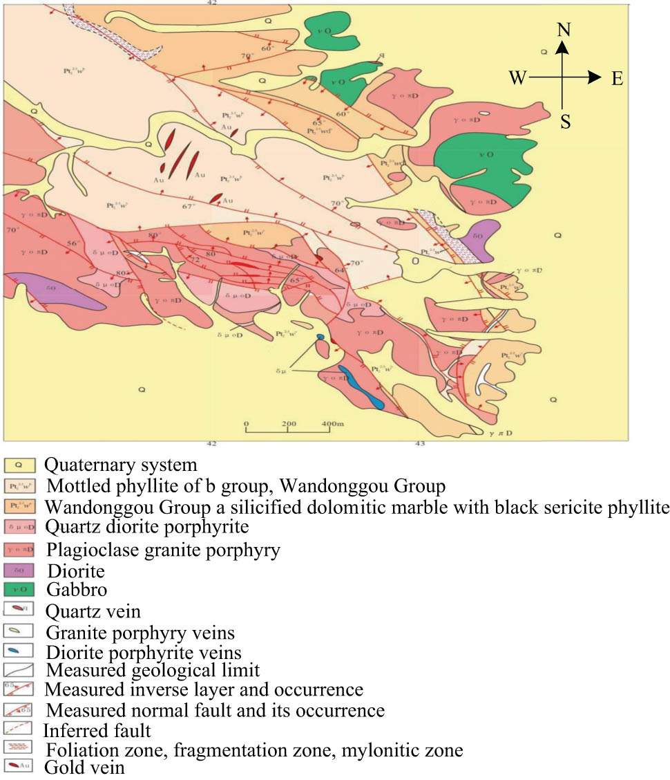
Geological map of the mining area.
The general direction of the structural line in this area is NW-SE, and the folds and faults are very complicated. In space, most of the gold ore bodies in each mining area are distributed near the wing of interlayer folds and their turning ends, and the shape and occurrence of ore bodies are obviously controlled by the wing foliation zone and the later faults. Tanjianshan compound anticline, secondary Qinglonggou syncline, and Jinlonggou syncline are developed in the mining area. The ductile deformation of rocks is caused by folding, bedding, or oblique bedding schistosity zones are generated at the folding wing due to relative sliding between layers, and dense axial cleavage is generated at the turning end, providing permeable micro-fracture space for hydrothermal activity. Jinlonggou syncline is a secondary syncline of the southwest wing of Tanjianshan compound anticline, which is located in the southeast section of the southwest wing of Tanjianshan compound anticline. The axial direction of syncline is NW-SE, the strike length is about 12 km, the axial direction is 305°, and the axial plane tends to southeast. The core is composed of the upper rock formation of the Wandonggou Group. The two wings are composed of the lower rock formation of the Wandonggou Group. Due to the destruction of faults and the emplacement of plagioclase granite porphyry, the south wing of syncline is sporadic. On the west side of Jinlonggou, the middle fold is uplifted, forming a secondary anticline and secondary synclines on both sides. The two secondary synclines control the positions of Tanjianshan gold deposit and Xijinggou gold deposit, respectively. There are developed fault structures in the area, which cause brittle deformation of rocks and form large-scale cracks or tectonic rock zones, providing a more unobstructed space for hydrothermal activities. Combined with its distribution law, it is mainly divided into two groups: northwest and northeast, followed by nearly north–south faults and nearly east–west faults.
The NW-trending thrust fault group, which is the main fault in the area, is numerous, extending in the NW-SE direction, with large scale and far extension, and branching and compounding along the strike. Most fault planes are inclined to the southwest, with an inclination of 55°–70°, and a few fault planes are inclined to the northeast, with an inclination of about 60°. The strike of fault planes is gentle and wavy, with the nature of compression and torsion. The occurrence of fault zone and its vicinity is disordered, the rocks are broken, and gold ore bodies are distributed locally along the broken zone, and its scale is generally small. This group of faults is the active channel of ore liquid during the metallogenic period, and the activities after ore play a destructive role in the ore body. The NE-trending fault group is generally small in scale, extending in the NE-SW direction, with the fault plane inclined to the NE or NW with an inclination of 50°–70°. It is mostly compressive and torsional in nature, mostly an interlayer fault zone or an interlayer detachment slip zone, and its activity mode is mainly “right-lateral,” which is characterized by multi-period activity. All of them are main ore-controlling structures.
4.3 Geophysical and chemical characteristics
4.3.1 Geophysical characteristics
The geophysical work carried out in this deposit is mainly 1:50,000 geomagnetic survey, which shows no magnetic anomalies in the deposit and its periphery, and does not delineate any geomagnetic anomalies.
4.3.2 Geochemical characteristics
4.3.2.1 Anomalous features of the primary halo
The formation of the gold primary halo in the Jinlonggou mining area of Tanlu Mountain is a complex geological process. In the mining area, the gas–water hydrothermal solution rich in gold mineralization elements and their associated elements (including volatile components) migrates and moves along specific structural fractures under the action of internal forces. When these ore-bearing hydrothermal solutions encounter drastic changes in external conditions or various geochemical obstacles over a short distance, the equilibrium conditions of their migration will be destroyed. At this time, each element will precipitate and separate out in a certain space and then form a primary halo. Three Au primary halo anomalies, Au1, Au2, and Au3, were delineated by predecessors in the mining area (Figure 4).
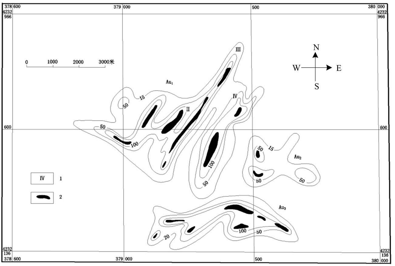
Anomaly map of Au primary halo in Jinlonggou mine area, Tanjianshan.
The lower limit of primary halo anomaly is determined by an intuitive scanning method, in which the lower limit of Au1 and Au2 is 15 × 10−9, and the lower limit of Au3 is 20 × 10−9. Au1 primary halo is mainly located in the west of the mining area, with an area of 0.14 km2, which is the largest gold primary halo in the mining area, including most phyllite-type gold ore bodies and mineralized bodies. The main body of the anomaly is NE-oriented, accompanied by NW-oriented structure, and its concentration center is mostly consistent with known ore bodies, and it can be divided into four concentration zones: 15–100 × 10−9. The concentration center in the northeast is divided into four structural zones from west to east: the average Au content in the first zone is 2983.8 × 10−9, and the concentration zone larger than 5,000 × 10−9 is small in scale, but the concentration zone larger than 1,000 × 10−9 has good continuity and large scale, with an overall length of 400 m. The average Au content in zone Ⅱ is 7,130 × 10−9, and the concentration zone larger than 5,000 × 10−9 is larger than that in zone Ⅰ. The average Au content in zone Ⅲ is 7,693 × 10−9, which is mainly the primary halo of zoneⅠ ore body, and the concentration zone larger than 5,000 × 10−9 is the largest, about 200 m long. The average Au content in zone IV is 100,328 × 10−9, and the concentration zone larger than 5,000 × 10−9 is large. Au3 primary halo is distributed in the Pubugou area, with an area of 45,000 m2, and its abnormal shape is relatively regular, and its general direction is nearly east–west, which basically contains phyllite-type and vein-type gold bodies in the Pubugou area. Au2 primary halo is located in the south of Wollongong, with an area of 4,310 m2, which is the smallest primary halo in the mining area. The main halo has three concentration centers and clear concentration zoning, which is actually a vein-type gold ore body. The main halo results of other indicator elements in the comprehensive mining area show that gold, silver, and As can form high-intensity and large-scale primary geochemical anomalies, and the concentration center is mainly related to ore bodies, which is an effective indicator element for finding such deposits.
4.3.2.2 Geochemical characteristics of ore-forming elements
The contents of trace elements in altered phyllite and other types of ores in the open pit of Jinlonggou Gold Mine were tested, analyzed, and counted. Through the correlation analysis of the test results of samples, it was found that the elements with a greater than critical correlation coefficient were positively correlated with Au, including As, Sb, and As(RAu-As = 0.998) and Sb(RAu-Sb = 0.914). The combination of Au, As, and Sb has close mineralization or halo formation with As and Sb in the process of Au mineralization and halo formation, which shows that the anomaly of As and Sb halo in this area has certain guiding significance for finding Au mineralization. At the same time, there is a significant positive correlation between Co and Ni, both of which are iron group elements with strong sulfur affinity and are easy to enter the sulfide lattice, which is related to sulfide alteration and halo formation. Through the analysis of the orthogonal rotation factor load matrix of elements, the results show that the main component factor of F1 is composed of Au, Sb, As, Ag, and Hg; Co, Zn, and Ni combination in F2; combination of Cu, Bi, and Pb in F3. When the distance coefficient is 15 in the pedigree diagram of R-cluster analysis, the elements are mainly divided into three groups. The first group contains elements such As Au, As, Sb, Hg, and Ag. The second group contains elements such as Co, Ni, and Zn. The third group contains elements such as Cu, Bi, and Pb. According to the analysis and statistics of the main metal elements in different types of gold ores, their surrounding rocks and the rocks around the mining area, it can be seen that the contents of Au, Ag, As, and Sb in the carbonaceous Shi Ying sericite schist around the mining area are very low, while the contents in the altered surrounding rocks near the mining area are greatly increased, forming a reduction field and an enrichment field of ore-forming elements and prospecting indicator elements, showing that from the far side of the ore body to the surrounding rocks near the mining area-gold bodies. The contents of Au, Ag, As, and Sb have increased to a great extent, indicating that hydrothermal alteration is the direct cause of the enrichment of ore-forming elements, and it also shows that ore-forming materials mainly come from magma, which seems to have little relationship with strata.
Through the analysis of rare earth and trace elements in carbonaceous phyllite-type gold ore, altered vein-type gold ore, granodiorite porphyry, and crystalline limestone in the mining area, it is shown that their REE distribution pattern curves are all light rare earth element-enriched, showing an obvious right-leaning trend, and the fractionation degree of light and heavy rare earth elements is high, showing that the weak negative europium anomaly is generally consistent. The standardized curves of trace elements are also consistent, which shows the diversity of ore-forming materials and the homology of magma.
4.4 Characteristics of ore-bearing fluid
Through careful observation under the microscope, the Shi Ying in different stages mainly consists of gas–liquid two-phase inclusions and a small amount of pure liquid inclusions, belonging to the NaCl-H2O system. The microscopic temperature measurement results of inclusions in different stages show that in the Shi Ying-pyrite stage, all inclusions are gas–liquid two-phase inclusions, which are mainly elliptical, water-drop-shaped, and irregular. The size of inclusions is 4–10 μm, and the gas–liquid ratio is 40–60%, and the highest can reach 90%. The measured freezing point temperature is between −5.2 and −11.7℃, and the uniform temperature is between 314.2 and 457.3℃. The fluid salinity is 8.67–15.75 wt% NaCl calculated from the freezing point temperature, and the fluid density is 0.586–0.788 g/cm3 according to the temperature–density relationship of inclusions in saline solution. The Shi Ying-pyrite polymetallic sulfide stage is mainly gas–liquid two-phase inclusions, which are oval, long, and irregular. The inclusion size is 6–10 μm, the gas–liquid ratio is 10–40%, the measured freezing point temperature is between −3.0 and −12.4℃, and the uniform temperature is between 150.2 and 209.3℃, mainly concentrated in 140–180℃. The calculated fluid salinity is 4.94–14.31 wt% NaCl, and the fluid density is 0.914–1.027 g/cm3. In the carbonate stage, gas–liquid two-phase inclusions are dominant, and pure liquid inclusions can be seen, showing a low capture temperature. The gas–liquid two-phase inclusions are observed and measured under the microscope, and the gas–liquid two-phase inclusions are nearly round and oval, with a size of 6–12 μm, a gas–liquid ratio of 10–20%, a measured freezing point temperature of −5.0–−1.3℃, and a uniform temperature of 126.5–149.8℃. The calculated fluid salinity is 2.23–7.86 wt% NaCl, and the fluid density is 0.950–0.990 g/cm3.
For different stages, the metallogenic pressure is obtained: The Shi Ying-pyrite stage is 28.93–54.92 MPa; the Shi Ying-pyrite polymetallic sulfide stage is 12.35–25.17 MPa; and the carbonate stage is 11.22–16.06 MPa. The relationship between pressure and depth by a previous study is used to calculate the metallogenic depth, which is 2.89–5.93, 1.24–2.52, and 1.12–1.60 km for different metallogenic stages.
5 Discussion
5.1 CSAMT determination structure
Based on the analysis of the geological characteristics and the source of ore-forming fluids in the study area, combined with the geophysical and chemical characteristics of this area and CSAMT, two prospecting targets were delineated in this study area. Geophysical exploration mainly includes gravity, magnetic methods, earthquake, and other methods, which can reveal the differences of physical properties such as density, magnetism, and velocity underground and infer possible ore bodies or structures. Geochemical survey analyzes the composition and content of chemical elements by collecting samples of rocks, soil, and water samples on the surface or underground, so as to reveal the distribution law of elements and provide clues for prospecting. Based on the comprehensive geological, geophysical, and geochemical information, the controlled source audio-frequency magnetotelluric method is adopted as an important prospecting method. Controlled source audio magnetotelluric method is a method to detect the resistivity change of the underground medium by using artificially emitted audio electromagnetic waves. This method has the advantages of high resolution, large detection depth, and little influence by topography and is especially suitable for finding deep concealed ore bodies. On the basis of delineating the prospecting target areas, the target veins of each target area are verified in engineering, and finally, two veins with industrial value are determined. Magnetic anomalies of M15 and M18-1 are delineated in this area by CSAMT measurement, and the abnormal results are shown in Figure 5.
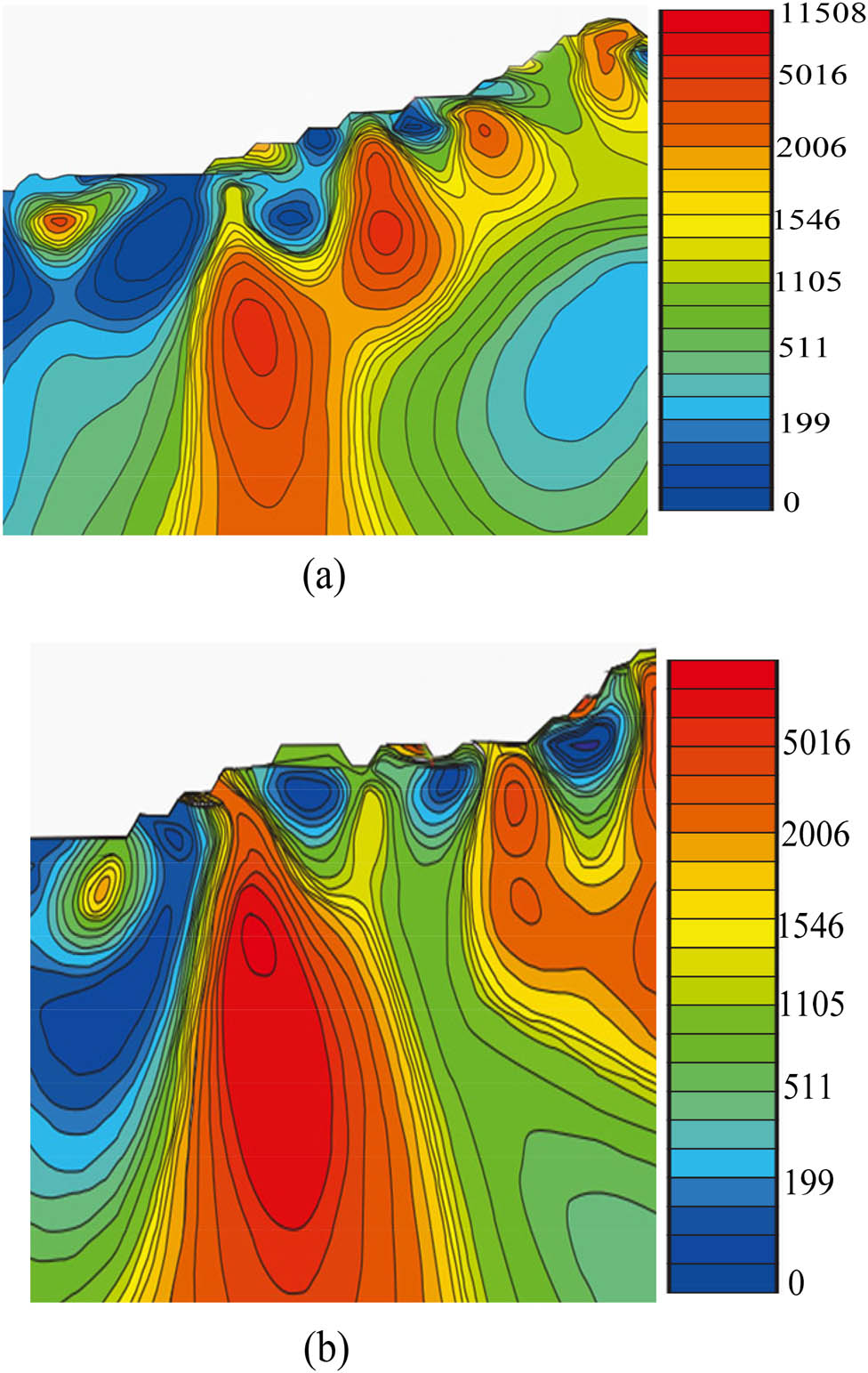
Structure of magnetic anomaly measurement: (a) M15 magnetic anomaly and (b) M18-1 magnetic anomaly.
The results of magnetic anomaly detection in Figure 5(a) show that the M15 anomaly is distributed in a nearly NW-SE beaded pattern, with moderate intensity and amplitude between (−100–600) nT. The profile plan shows that the anomaly is mainly an irregular positive anomaly with little gradient change. The strata exposed on the abnormal surface are volcanic rocks under the Tanjianshan Group in Cambrian-Ordovician, and the lithology is mainly basalt and andesite. Early Ordovician gray-green fine-grained gabbro; the exposed lithology in some sections is tuffaceous sandstone. According to the measurement of magnetic properties, the average magnetic susceptibility of tuffaceous sandstone is 364.6 × 10−6 × 4π·SI, the average residual magnetization is 258.8 × 10⁻³ A/m, the average magnetic susceptibility of basalt is 811.8 × 10−6 × 4π·SI, and the average residual magnetization is 296.6 × 10⁻³ A/m. Among them, gabbro has the strongest magnetism, with the maximum magnetic susceptibility of 8815.6 × 10−6 × 4π·SI and the residual magnetization of 1,230 × 10−3 A/m. A geological survey found that magnetite was found in gabbro. Based on a comprehensive analysis, it is inferred that the anomaly may be related to basic volcanic rocks and magnetite-bearing gabbro.
Figure 5(b) shows that the abnormal area of M18-1 is about 10 km2. On the plan view of the section, there are positive and negative associated anomalies with sawtooth jump, with strong intensity and great gradient change, and the amplitude is between −474 and 820 nt. The lithology of abnormal surface exposure is feldspar Shi Ying sandstone; And gabbro intrusion, its magnetic distribution is uneven. According to the determination of magnetic properties, the average magnetic susceptibility of feldspathic Shi Ying sandstone is 568.4 × 10−6 × 4π·SI, the average residual magnetization is 160 × 10−3 A/m, the average magnetic susceptibility of gabbro is 1191.9 × 10−6 × 4π·SI, and the average residual magnetization is 302.5 × 10⁻³ A/m. The anomaly is well matched with the 1:50,000 geochemical anomaly of HS29乙3Cu(AgCrPbVCo), and magnetite is found in gabbro in the geological survey. Therefore, the anomaly may be related to magnetite gabbro. At the same time, it is also a favorable area for finding polymetallic mines such as iron and copper.
5.2 Analysis of geochemical anomalies
Through chemical characteristics and CSAMT detection, the geochemical survey has delineated 14 comprehensive anomalies and 17 single gold anomalies in the area. The main body of comprehensive anomalies is Cu, which is distributed in the exposed area of volcanic rocks and basic rocks in the central mining area, and single Au anomalies are distributed along the structure.
5.2.1 Abnormal characteristics of GA60乙3Au (Cr, Ni, Co, Cu)
Au is the main element, and the associated elements Cr, Ni, Co, and Cu are located outside the general survey area. The maximum value of Au is 36.8 × 10⁻⁹, and the average value is 22.7 × 10⁻⁹. There are four abnormal points, with three-level concentration zoning, and the concentration trend is obvious (Table 2). Late Devonian adamellite and altered basalt of volcanic rock formation under the Tanjianshan Group are exposed in the concentration center.
Abnormal characteristics of GA60 乙3Au (Cr, Ni, Co, Cu)
| Element | Lower limit of anomaly | Count | Standard deviation | Relative standard deviation | Contrast | Abnormal | Relative |
|---|---|---|---|---|---|---|---|
| scale | scale | ||||||
| Au | 3.5 | 4 | 10.29 | 0.45 | 6.49 | 0.66 | 79.4 |
| Co | 35 | 2 | 0.21 | 0.01 | 1.12 | 0.04 | 4.3 |
| Cr | 120 | 2 | 3.54 | 0.02 | 1.46 | 0.06 | 6.8 |
| Cu | 70 | 2 | 1.13 | 0.01 | 1.17 | 0.03 | 3.9 |
| Ni | 60 | 2 | 0.78 | 0.01 | 1.16 | 0.05 | 5.6 |
Most of the abnormal areas are covered by Quaternary, and many diabase and gabbro veins are found in the surface abnormal areas. Through chemical sample analysis, there is no mineralization. Preliminary analysis shows that anomalies such as Cr, Co, Ni, and Cu are basic-ultrabasic dikes, which cause background anomalies. Through further tracing, a mineralized Shi Ying vein is found, with the exposed length of Shi Ying vein of about 5 m and the width of 1.06 m, Limonite and pyrite were developed in quartz veins. Au grade was 3.29 g/t by analysis of XTG-JKH 32, which further confirmed that the abnormality was minerenic.
5.2.2 Au anomaly characteristics of single gold
The number of Au anomaly points is 4, with the maximum value of Au being 572 × 10−9, the minimum value being 19.2 × 10⁻⁹, and the average value being 216.4 × 10⁻⁹, with obvious three-level concentration zoning, large anomaly scale, and high peak value. The altered basalt of volcanic rock formation under the Tanjianshan Group is exposed in the abnormal position.
According to the trench exploration project, at present, seven Au ore bodies have been delineated in the middle part (Au-2) of SB1 and SB3, with the controlled length of 80–550 m, the true thickness of 1.02–3.36 m, the average Au grade of 1.32–4.12 g/t, and the highest Au grade of 8.70 g/t. There are 10 Au mineralized bodies with a controlled length of 80–550 m, a true thickness of 0.42–3.84 m, an average content of 0.29–0.38 g/t, and a maximum content of 0.84 g/t, and one Cu ore body is controlled by a single project, with a true thickness of 1.84 m, an average grade of 0.22%, and a maximum grade of 0.24%, which is the main one in the area at present.
6 Conclusion
Based on the study of geological background, metallogenic conditions, geochemistry, and physical characteristics of the triangle top gold mine in Saishiteng area, the geological characteristics of the study area are systematically analyzed, and the prospecting target area is delineated in the study area with the CSAMT method. After engineering verification, two gold veins were delineated on the basis of the prospecting target area, and good prospecting results were obtained, and the following conclusions were summarized:
No intrusive rocks of Variscan have been discovered in the triangle top mining area, and the existing test results are all concentrated in 460–480 Ma, and the age is Early-Middle Ordovician, indicating that the mineralization in this area is not directly related to magmatic emplacement of Variscan, and the early-Middle Ordovician intrusive rocks provide the initial source beds for triangle top and Xitinggou mining areas. The subduction of the former Tethys Ocean and continental margin from 514 to 450 Ma and the massive ductile deformation formed during the continent continent collision process after the closure of the ocean basin from 445 to 420 Ma are the main mechanisms of gold enrichment and integration in this area, and 420 Ma can be used as the lower age limit of gold enrichment and integration, so it is inferred that the gold mineralization age in this area is: 460 Ma > 420 Ma, and the metallogenic tectonic environment is continental margin subduction or continent continent collision.
In the ore-bearing structural alteration zone of the triangle top mining area, SB2 and SB4 are both left-lateral shear zones, which is consistent with the regional thrust of Ou Long Brooke landmass obliquely to the left of Qaidam landmass. Among them, the SB4 structural alteration zone was superimposed with high-angle thrust brittle fracture in the later stage, which played a positive role in the enrichment of gold mineralization in the later stage, and the gold mineralization was strictly controlled near the floor of brittle fracture.
The enrichment of gold in the triangle top mining area is obviously different from that in the Tanjianshan area. The enrichment of gold in the triangle top and Xitinggou mining areas is mainly related to the initial enrichment of Caledonian magmatism, and the late continental margin subduction or strong regional metamorphism and deformation caused by continent collision, resulting in the final enrichment of gold. The metallogenic age is limited to 420–460 Ma, which was formed under the geodynamic background of strong compression.
Acknowledgments
The study was supported by the Qinghai Provincial Bureau of Geology and Mineral Resources (Qingdi Mine [2022] No. 32) and the “Light of the West” Talents Training Program of the Chinese Academy of Sciences.
-
Funding information: The study was supported by the Qinghai Provincial Bureau of Geology and Mineral Resources (Qingdi Mine [2022] No. 32) and the “Light of the West” Talents Training Program of the Chinese Academy of Sciences.
-
Author contributions: Changyun Liu: Conceptualization, Methodology, Formal analysis, Investigation, Writing – Original Draft, Visualization. Jizu Kang: Supervision, Project administration, Funding acquisition, Resources, Writing – Review & Editing. Youwen Ma: Validation, Data Curation, Software, Writing – Review & Editing. Yanwen Fu: Investigation, Formal analysis, Visualization, Writing – Review & Editing. Lexun Zhou: Resources, Investigation, Methodology, Writing – Review & Editing. Chengxiu Tian: Data Curation, Validation, Writing – Review & Editing.
-
Conflict of interest: Authors state no conflict of interest.
-
Data availability statement: The datasets generated during and analysed during the current study are available from the corresponding author on reasonable request.
References
[1] Chen X, Wu YS, Zhou KF, Yuan XC, Wang Y. Origin and evolution of ore fluids of the jinwozi gold deposit, beishan orogen, NW China. Ore Geol Rev. 2021;134(4):104100.10.1016/j.oregeorev.2021.104100Suche in Google Scholar
[2] Xiao Q, Zhou T, Hollings P, Wang S, Yuan F. The role of porphyry–related skarns in the chating porphyry copper and gold deposit, eastern China. Ore Geol Rev. 2021;133(11–12):104096.10.1016/j.oregeorev.2021.104096Suche in Google Scholar
[3] Du B, Shen J, Santosh M, Liu H, Xu K. Genesis of the Gangcha gold deposit, West Qinling Orogen, China: Constraints from Rb-Sr geochronology, in-situ sulfur isotopes and trace element geochemistry of pyrite. Ore Geol Rev. 2021;138(B10):104350.10.1016/j.oregeorev.2021.104350Suche in Google Scholar
[4] Espitia SLM, Lapidus GT. Arsenic removal strategy in the processing of an arsenopyritic refractory gold ore. Hydrometallurgy. 2021;203(1):105628.Suche in Google Scholar
[5] Wang Q, Wang X, Liu H, Tian M, Xiong Y. Targeting deep-seated gold deposits: a study from the qujia gold deposit, shandong province, china. Appl Geochem. 2021;130(1):104982.10.1016/j.apgeochem.2021.104982Suche in Google Scholar
[6] Liu XY, Tan J, He HY, Gan JR. Origin of the tudui–shawang gold deposit, jiaodong peninsula, north china craton: constraints from fluid inclusion and H-O-He-Ar-S-Pb isotopic compositions. Ore Geol Rev. 2021;133(B6):104125.10.1016/j.oregeorev.2021.104125Suche in Google Scholar
[7] Berezovsky A, Pieczonka J, Piestrzynski A. Silver-gold and polymetallic mineralization in the banded iron formations deposit in Kryvyi Rih, Ukraine. Precambrian Res. 2021;363(2):106326.10.1016/j.precamres.2021.106326Suche in Google Scholar
[8] Aguilar G, Valdés A, Cabré A, Galdames F. Flash floods controlling Cu, Pb, As and Hg variations in fluvial sediments of a river impacted by metal mining in the Atacama Desert. J South Am Earth Sci. 2021;109(4):103290.10.1016/j.jsames.2021.103290Suche in Google Scholar
[9] Vazelhes VDBD, Beaudoin G, Mcmartin I, Cté-Mantha O, Boulianne-Verschelden N. Assessment of the Amaruq gold deposit signature in glacial sediments using multivariate geochemical data analysis and indicator minerals. J Geochem Explor. 2021;228(4):106800.10.1016/j.gexplo.2021.106800Suche in Google Scholar
[10] An W, Chen J, Li Y, Wei J, Wang J. The superposition characteristics of primary halo in the daping gold deposit, Yunnan province, China and its significance for exploration. J Geochem Explor. 2021;228(2):106809.10.1016/j.gexplo.2021.106809Suche in Google Scholar
[11] Daneshvar N, Maanijou M, Lentz DR, Azizi H, Maruoka T. Interpretation of hydrothermal evolution in the Qolqoleh gold deposit, southwest of Saqqez, Iran: analysis of pyrite by La-Icp-Ms and sulfur isotopes. Ore Geol Rev. 2021;133(4):104087.10.1016/j.oregeorev.2021.104087Suche in Google Scholar
[12] Toubri Y, Demers I, Andrée P, Geneviève P, Beier NA. Merging 3d geological modeling and stochastic simulation to foster waste rock upstream management. J Geochem Explor. 2021;224(7):106739.10.1016/j.gexplo.2021.106739Suche in Google Scholar
[13] Jia-Bin Y, Xuan Z, Xi G, Tao H. Magnetotelluric impedance estimation based on clustering analysis. J Appl Geophys. 2021;189(3):104322.10.1016/j.jappgeo.2021.104322Suche in Google Scholar
[14] Zhang J, Liu J, Feng B, Zheng Y, Liu Z. Three-dimensional magnetotelluric modeling using the finite element model reduction algorithm. Comput Geosci. 2021;151(3):104750.10.1016/j.cageo.2021.104750Suche in Google Scholar
[15] Fernández-Lozano J, Sanz-Ablanedo E. Unraveling the morphological constraints on Roman gold mining hydraulic infrastructure in NW Spain. A UAV-derived photogrammetric and multispectral approach. Remote Sens. 2021;13(2):291.10.3390/rs13020291Suche in Google Scholar
[16] Diaz-Morales DM, Erasmus JH, Bosch S, Nachev M, Sures B. Metal contamination and toxicity of soils and river sediments from the world’s largest platinum mining area. Environ Pollut. 2021;286(335):117284.10.1016/j.envpol.2021.117284Suche in Google Scholar PubMed
[17] Espitia SLM, Lapidus GT. Arsenic removal strategy in the processing of an arsenopyritic refractory gold ore. Hydrometallurgy. 2021;203(1):105628.10.1016/j.hydromet.2021.105628Suche in Google Scholar
[18] Gui Q, Wang S, Zhang L. The mechanism of ultrasound oxidation effect on the pyrite for refractory gold ore pretreatment. Arabian J Chem. 2021;14(4):103045.10.1016/j.arabjc.2021.103045Suche in Google Scholar
[19] Michelsen L, Elliott GM, Christopher A-L, JacksonGawthorpe RL, Wilson P, Sharp IR. Tectono‐stratigraphic development of a salt-influenced rift margin: Halten terrace, offshore mid‐Norway. Basin Res. 2021;33(6):3295–320.10.1111/bre.12603Suche in Google Scholar
[20] Tyagunov A, Tyagunov G, Milder O, Tarasov D. Detection of the liquid–liquid transitions in superalloys melts upon overheating and relaxation by the electromagnetic method. J Appl Phys. 2021;129(1):015107.10.1063/5.0027756Suche in Google Scholar
© 2025 the author(s), published by De Gruyter
This work is licensed under the Creative Commons Attribution 4.0 International License.
Artikel in diesem Heft
- Research Articles
- Seismic response and damage model analysis of rocky slopes with weak interlayers
- Multi-scenario simulation and eco-environmental effect analysis of “Production–Living–Ecological space” based on PLUS model: A case study of Anyang City
- Remote sensing estimation of chlorophyll content in rape leaves in Weibei dryland region of China
- GIS-based frequency ratio and Shannon entropy modeling for landslide susceptibility mapping: A case study in Kundah Taluk, Nilgiris District, India
- Natural gas origin and accumulation of the Changxing–Feixianguan Formation in the Puguang area, China
- Spatial variations of shear-wave velocity anomaly derived from Love wave ambient noise seismic tomography along Lembang Fault (West Java, Indonesia)
- Evaluation of cumulative rainfall and rainfall event–duration threshold based on triggering and non-triggering rainfalls: Northern Thailand case
- Pixel and region-oriented classification of Sentinel-2 imagery to assess LULC dynamics and their climate impact in Nowshera, Pakistan
- The use of radar-optical remote sensing data and geographic information system–analytical hierarchy process–multicriteria decision analysis techniques for revealing groundwater recharge prospective zones in arid-semi arid lands
- Effect of pore throats on the reservoir quality of tight sandstone: A case study of the Yanchang Formation in the Zhidan area, Ordos Basin
- Hydroelectric simulation of the phreatic water response of mining cracked soil based on microbial solidification
- Spatial-temporal evolution of habitat quality in tropical monsoon climate region based on “pattern–process–quality” – a case study of Cambodia
- Early Permian to Middle Triassic Formation petroleum potentials of Sydney Basin, Australia: A geochemical analysis
- Micro-mechanism analysis of Zhongchuan loess liquefaction disaster induced by Jishishan M6.2 earthquake in 2023
- Prediction method of S-wave velocities in tight sandstone reservoirs – a case study of CO2 geological storage area in Ordos Basin
- Ecological restoration in valley area of semiarid region damaged by shallow buried coal seam mining
- Hydrocarbon-generating characteristics of Xujiahe coal-bearing source rocks in the continuous sedimentary environment of the Southwest Sichuan
- Hazard analysis of future surface displacements on active faults based on the recurrence interval of strong earthquakes
- Structural characterization of the Zalm district, West Saudi Arabia, using aeromagnetic data: An approach for gold mineral exploration
- Research on the variation in the Shields curve of silt initiation
- Reuse of agricultural drainage water and wastewater for crop irrigation in southeastern Algeria
- Assessing the effectiveness of utilizing low-cost inertial measurement unit sensors for producing as-built plans
- Analysis of the formation process of a natural fertilizer in the loess area
- Machine learning methods for landslide mapping studies: A comparative study of SVM and RF algorithms in the Oued Aoulai watershed (Morocco)
- Chemical dissolution and the source of salt efflorescence in weathering of sandstone cultural relics
- Molecular simulation of methane adsorption capacity in transitional shale – a case study of Longtan Formation shale in Southern Sichuan Basin, SW China
- Evolution characteristics of extreme maximum temperature events in Central China and adaptation strategies under different future warming scenarios
- Estimating Bowen ratio in local environment based on satellite imagery
- 3D fusion modeling of multi-scale geological structures based on subdivision-NURBS surfaces and stratigraphic sequence formalization
- Comparative analysis of machine learning algorithms in Google Earth Engine for urban land use dynamics in rapidly urbanizing South Asian cities
- Study on the mechanism of plant root influence on soil properties in expansive soil areas
- Simulation of seismic hazard parameters and earthquakes source mechanisms along the Red Sea rift, western Saudi Arabia
- Tectonics vs sedimentation in foredeep basins: A tale from the Oligo-Miocene Monte Falterona Formation (Northern Apennines, Italy)
- Investigation of landslide areas in Tokat-Almus road between Bakımlı-Almus by the PS-InSAR method (Türkiye)
- Predicting coastal variations in non-storm conditions with machine learning
- Cross-dimensional adaptivity research on a 3D earth observation data cube model
- Geochronology and geochemistry of late Paleozoic volcanic rocks in eastern Inner Mongolia and their geological significance
- Spatial and temporal evolution of land use and habitat quality in arid regions – a case of Northwest China
- Ground-penetrating radar imaging of subsurface karst features controlling water leakage across Wadi Namar dam, south Riyadh, Saudi Arabia
- Rayleigh wave dispersion inversion via modified sine cosine algorithm: Application to Hangzhou, China passive surface wave data
- Fractal insights into permeability control by pore structure in tight sandstone reservoirs, Heshui area, Ordos Basin
- Debris flow hazard characteristic and mitigation in Yusitong Gully, Hengduan Mountainous Region
- Research on community characteristics of vegetation restoration in hilly power engineering based on multi temporal remote sensing technology
- Identification of radial drainage networks based on topographic and geometric features
- Trace elements and melt inclusion in zircon within the Qunji porphyry Cu deposit: Application to the metallogenic potential of the reduced magma-hydrothermal system
- Pore, fracture characteristics and diagenetic evolution of medium-maturity marine shales from the Silurian Longmaxi Formation, NE Sichuan Basin, China
- Study of the earthquakes source parameters, site response, and path attenuation using P and S-waves spectral inversion, Aswan region, south Egypt
- Source of contamination and assessment of potential health risks of potentially toxic metal(loid)s in agricultural soil from Al Lith, Saudi Arabia
- Regional spatiotemporal evolution and influencing factors of rural construction areas in the Nanxi River Basin via GIS
- An efficient network for object detection in scale-imbalanced remote sensing images
- Effect of microscopic pore–throat structure heterogeneity on waterflooding seepage characteristics of tight sandstone reservoirs
- Environmental health risk assessment of Zn, Cd, Pb, Fe, and Co in coastal sediments of the southeastern Gulf of Aqaba
- A modified Hoek–Brown model considering softening effects and its applications
- Evaluation of engineering properties of soil for sustainable urban development
- The spatio-temporal characteristics and influencing factors of sustainable development in China’s provincial areas
- Application of a mixed additive and multiplicative random error model to generate DTM products from LiDAR data
- Gold vein mineralogy and oxygen isotopes of Wadi Abu Khusheiba, Jordan
- Prediction of surface deformation time series in closed mines based on LSTM and optimization algorithms
- 2D–3D Geological features collaborative identification of surrounding rock structural planes in hydraulic adit based on OC-AINet
- Spatiotemporal patterns and drivers of Chl-a in Chinese lakes between 1986 and 2023
- Land use classification through fusion of remote sensing images and multi-source data
- Nexus between renewable energy, technological innovation, and carbon dioxide emissions in Saudi Arabia
- Analysis of the spillover effects of green organic transformation on sustainable development in ethnic regions’ agriculture and animal husbandry
- Factors impacting spatial distribution of black and odorous water bodies in Hebei
- Large-scale shaking table tests on the liquefaction and deformation responses of an ultra-deep overburden
- Impacts of climate change and sea-level rise on the coastal geological environment of Quang Nam province, Vietnam
- Reservoir characterization and exploration potential of shale reservoir near denudation area: A case study of Ordovician–Silurian marine shale, China
- Seismic prediction of Permian volcanic rock reservoirs in Southwest Sichuan Basin
- Application of CBERS-04 IRS data to land surface temperature inversion: A case study based on Minqin arid area
- Geological characteristics and prospecting direction of Sanjiaoding gold mine in Saishiteng area
- Research on the deformation prediction model of surrounding rock based on SSA-VMD-GRU
- Geochronology, geochemical characteristics, and tectonic significance of the granites, Menghewula, Southern Great Xing’an range
- Hazard classification of active faults in Yunnan base on probabilistic seismic hazard assessment
- Characteristics analysis of hydrate reservoirs with different geological structures developed by vertical well depressurization
- Estimating the travel distance of channelized rock avalanches using genetic programming method
- Landscape preferences of hikers in Three Parallel Rivers Region and its adjacent regions by content analysis of user-generated photography
- New age constraints of the LGM onset in the Bohemian Forest – Central Europe
- Characteristics of geological evolution based on the multifractal singularity theory: A case study of Heyu granite and Mesozoic tectonics
- Soil water content and longitudinal microbiota distribution in disturbed areas of tower foundations of power transmission and transformation projects
- Oil accumulation process of the Kongdian reservoir in the deep subsag zone of the Cangdong Sag, Bohai Bay Basin, China
- Investigation of velocity profile in rock–ice avalanche by particle image velocimetry measurement
- Optimizing 3D seismic survey geometries using ray tracing and illumination modeling: A case study from Penobscot field
- Sedimentology of the Phra That and Pha Daeng Formations: A preliminary evaluation of geological CO2 storage potential in the Lampang Basin, Thailand
- Improved classification algorithm for hyperspectral remote sensing images based on the hybrid spectral network model
- Map analysis of soil erodibility rates and gully erosion sites in Anambra State, South Eastern Nigeria
- Identification and driving mechanism of land use conflict in China’s South-North transition zone: A case study of Huaihe River Basin
- Evaluation of the impact of land-use change on earthquake risk distribution in different periods: An empirical analysis from Sichuan Province
- A test site case study on the long-term behavior of geotextile tubes
- An experimental investigation into carbon dioxide flooding and rock dissolution in low-permeability reservoirs of the South China Sea
- Detection and semi-quantitative analysis of naphthenic acids in coal and gangue from mining areas in China
- Comparative effects of olivine and sand on KOH-treated clayey soil
- YOLO-MC: An algorithm for early forest fire recognition based on drone image
- Earthquake building damage classification based on full suite of Sentinel-1 features
- Potential landslide detection and influencing factors analysis in the upper Yellow River based on SBAS-InSAR technology
- Assessing green area changes in Najran City, Saudi Arabia (2013–2022) using hybrid deep learning techniques
- An advanced approach integrating methods to estimate hydraulic conductivity of different soil types supported by a machine learning model
- Hybrid methods for land use and land cover classification using remote sensing and combined spectral feature extraction: A case study of Najran City, KSA
- Streamlining digital elevation model construction from historical aerial photographs: The impact of reference elevation data on spatial accuracy
- Analysis of urban expansion patterns in the Yangtze River Delta based on the fusion impervious surfaces dataset
- A metaverse-based visual analysis approach for 3D reservoir models
- Late Quaternary record of 100 ka depositional cycles on the Larache shelf (NW Morocco)
- Integrated well-seismic analysis of sedimentary facies distribution: A case study from the Mesoproterozoic, Ordos Basin, China
- Study on the spatial equilibrium of cultural and tourism resources in Macao, China
- Urban road surface condition detecting and integrating based on the mobile sensing framework with multi-modal sensors
- Application of improved sine cosine algorithm with chaotic mapping and novel updating methods for joint inversion of resistivity and surface wave data
- The synergistic use of AHP and GIS to assess factors driving forest fire potential in a peat swamp forest in Thailand
- Dynamic response analysis and comprehensive evaluation of cement-improved aeolian sand roadbed
- Rock control on evolution of Khorat Cuesta, Khorat UNESCO Geopark, Northeastern Thailand
- Gradient response mechanism of carbon storage: Spatiotemporal analysis of economic-ecological dimensions based on hybrid machine learning
- Comparison of several seismic active earth pressure calculation methods for retaining structures
- Mantle dynamics and petrogenesis of Gomer basalts in the Northwestern Ethiopia: A geochemical perspective
- Study on ground deformation monitoring in Xiong’an New Area from 2021 to 2023 based on DS-InSAR
- Paleoenvironmental characteristics of continental shale and its significance to organic matter enrichment: Taking the fifth member of Xujiahe Formation in Tianfu area of Sichuan Basin as an example
- Equipping the integral approach with generalized least squares to reconstruct relict channel profile and its usage in the Shanxi Rift, northern China
- InSAR-driven landslide hazard assessment along highways in hilly regions: A case-based validation approach
- Attribution analysis of multi-temporal scale surface streamflow changes in the Ganjiang River based on a multi-temporal Budyko framework
- Maps analysis of Najran City, Saudi Arabia to enhance agricultural development using hybrid system of ANN and multi-CNN models
- Hybrid deep learning with a random forest system for sustainable agricultural land cover classification using DEM in Najran, Saudi Arabia
- Long-term evolution patterns of groundwater depth and lagged response to precipitation in a complex aquifer system: Insights from Huaibei Region, China
- Remote sensing and machine learning for lithology and mineral detection in NW, Pakistan
- Spatial–temporal variations of NO2 pollution in Shandong Province based on Sentinel-5P satellite data and influencing factors
- Numerical modeling of geothermal energy piles with sensitivity and parameter variation analysis of a case study
- Stability analysis of valley-type upstream tailings dams using a 3D model
- Variation characteristics and attribution analysis of actual evaporation at monthly time scale from 1982 to 2019 in Jialing River Basin, China
- Investigating machine learning and statistical approaches for landslide susceptibility mapping in Minfeng County, Xinjiang
- Investigating spatiotemporal patterns for comprehensive accessibility of service facilities by location-based service data in Nanjing (2016–2022)
- A pre-treatment method for particle size analysis of fine-grained sedimentary rocks, Bohai Bay Basin, China
- Study on the formation mechanism of the hard-shell layer of liquefied silty soil
- Comprehensive analysis of agricultural CEE: Efficiency assessment, mechanism identification, and policy response – A case study of Anhui Province
- Simulation study on the damage and failure mechanism of the surrounding rock in sanded dolomite tunnels
- Towards carbon neutrality: Spatiotemporal evolution and key influences on agricultural ecological efficiency in Northwest China
- Review Articles
- Humic substances influence on the distribution of dissolved iron in seawater: A review of electrochemical methods and other techniques
- Applications of physics-informed neural networks in geosciences: From basic seismology to comprehensive environmental studies
- Ore-controlling structures of granite-related uranium deposits in South China: A review
- Shallow geological structure features in Balikpapan Bay East Kalimantan Province – Indonesia
- A review on the tectonic affinity of microcontinents and evolution of the Proto-Tethys Ocean in Northeastern Tibet
- Advancements in machine learning applications for mineral prospecting and geophysical inversion: A review
- Special Issue: Natural Resources and Environmental Risks: Towards a Sustainable Future - Part II
- Depopulation in the Visok micro-region: Toward demographic and economic revitalization
- Special Issue: Geospatial and Environmental Dynamics - Part II
- Advancing urban sustainability: Applying GIS technologies to assess SDG indicators – a case study of Podgorica (Montenegro)
- Spatiotemporal and trend analysis of common cancers in men in Central Serbia (1999–2021)
- Minerals for the green agenda, implications, stalemates, and alternatives
- Spatiotemporal water quality analysis of Vrana Lake, Croatia
- Functional transformation of settlements in coal exploitation zones: A case study of the municipality of Stanari in Republic of Srpska (Bosnia and Herzegovina)
- Hypertension in AP Vojvodina (Northern Serbia): A spatio-temporal analysis of patients at the Institute for Cardiovascular Diseases of Vojvodina
- Regional patterns in cause-specific mortality in Montenegro, 1991–2019
- Spatio-temporal analysis of flood events using GIS and remote sensing-based approach in the Ukrina River Basin, Bosnia and Herzegovina
- Flash flood susceptibility mapping using LiDAR-Derived DEM and machine learning algorithms: Ljuboviđa case study, Serbia
- Geocultural heritage as a basis for geotourism development: Banjska Monastery, Zvečan (Serbia)
- Assessment of groundwater potential zones using GIS and AHP techniques – A case study of the zone of influence of Kolubara Mining Basin
- Impact of the agri-geographical transformation of rural settlements on the geospatial dynamics of soil erosion intensity in municipalities of Central Serbia
- Where faith meets geomorphology: The cultural and religious significance of geodiversity explored through geospatial technologies
- Applications of local climate zone classification in European cities: A review of in situ and mobile monitoring methods in urban climate studies
- Complex multivariate water quality impact assessment on Krivaja River
- Ionization hotspots near waterfalls in Eastern Serbia’s Stara Planina Mountain
- Shift in landscape use strategies during the transition from the Bronze age to Iron age in Northwest Serbia
- Assessing the geotourism potential of glacial lakes in Plav, Montenegro: A multi-criteria assessment by using the M-GAM model
- Flash flood potential index at national scale: Susceptibility assessment within catchments
- SWAT modelling and MCDM for spatial valuation in small hydropower planning