
Ground-penetrating radar imaging of subsurface karst features controlling water leakage across Wadi Namar dam, south Riyadh, Saudi Arabia
-
Saad S. Alarifi
 ,
Elkhedr Ibrahim
,
Elkhedr Ibrahim

Abstract
This article presents a study conducted at the Wadi Namar dam in southern Riyadh, Saudi Arabia, using ground-penetrating radar (GPR) to investigate underlying karst features influencing water leakage. Through the acquisition of 38 GPR profiles downstream of the dam, the investigation reveals diverse structural irregularities primarily within the Jubaila carbonate rocks beneath the dam. The processed GPR data delineated vertical fractures dissecting the carbonate bedrock, as well as parallel sheet-like lateral fracture zones. These features enhance groundwater permeability, facilitating both vertical and lateral flow, thus impacting water leakage from the dam. Additionally, the presence of dissolution and karstic cavity structures is indicated by high-resolution GPR reflections, potentially acting as underground water reservoirs. The findings underscore the significance of karst features in governing water seepage at the dam site, emphasizing the importance of geological and geophysical investigations for dam safety and management.
1 Introduction
Saudi Arabia, situated in an arid region with limited rainfall and surface freshwater resources, has implemented numerous dams across its streams to collect and manage rainwater, thereby mitigating flood risks. However, recent instances of groundwater seepage have highlighted vulnerabilities in these structures. Among them is the Namar concrete dam, which was built across the northeast-oriented Wadi Namar, a western tributary of the 80-km-long Wadi Hanifa, located to the south of Riyadh, the capital city of KSA (Figure 1). The Namar dam has a surface water lake that covers a total area of 200,000 m2, measuring 2 km in length, 170 m in width, and 20 m in depth. Resting on the carbonate bedrock of the Upper Jurassic karst Jubaila Formation (Figure 1), the dam and its upstream lake directly interface with this karst formation, known for its fractures and dissolution cavities [1,2]. This karst formation, at various locations in the Kingdom, displays fractures and dissolution cavities [3,4]. In karst terrains, rainfall and subsurface groundwater flow, coupled with extensive fracturing, lead to the development of karst features like solution-widened fractures and cavities. These features play a critical role in controlling vertical infiltration and shallow water flow, occasionally causing partial collapses and groundwater seepage. Therefore, the safety of dams and the potential impact of geological karst features necessitate thorough geological and geophysical investigations [5,6]. Water leakage, a common issue at dam sites, typically occurs through the bedrock, especially in dams constructed on karstic bedrock [7–11]. Milanović [12] discussed the leakage problem beneath many dams constructed on karst formations, some of which suffer from heavy leakage in the dam lake. Among the variety of geological and hydrological features, karst features are the most vulnerable, allowing groundwater to flow across the fracture and void system [13,14]. The development of flow conduits within karst formations leads to high permeability, allowing rapid transfer of groundwater beneath the dam body [7]. The Namar dam site, where groundwater emerges downstream of the dam (Figure 2), is particularly susceptible to leakage through karst conduits, potentially leading to subsurface collapse (Figure 3). This problem has not yet been definitively resolved and requires more in-depth studies to be understood. Hence, this study aims to address this issue and provide a comprehensive understanding of subsurface geological features and their impact on potential water leakage at the dam site. For this purpose, detailed ground-penetrating radar (GPR) imaging is used. Previous studies have demonstrated the efficacy of the GPR method in karst environments and groundwater flow investigations. Mellor et al. [15] applied the GPR method to detect the effect of solution cavities in North Carolina. Alhumimidi et al. [16] verified the fracture pattern of the Al-Khuff Formation outcrops in the Al-Qassim area, Saudi Arabia, using GPR and ERT geophysical surveys. The results revealed the presence of laterally extensive and vertically oriented fractures, identified as vertical to sub-vertical, across the measured sections. Almadani et al. [17] investigated near-surface karstification and fractured subsurface features beneath the site of the El-Elb dam northwest of Riyadh, using GPR and 2D resistivity techniques. Romano et al. [18] Romano et al. [19] used integrated geophysical techniques to verify the existence of underground caves and voids and provided useful information on their possible extension and depth; in addition, they detected likely pathways of water infiltration. The karst features in the limestone formations within and around the Riyadh region have been studied by many authors (e.g., [2,20–25]).

(a) Location of the studied site. (b) Simplified geologic map of south Riyadh showing the location of Wadi Namar dam. (c) A satellite image showing Wadi Namar dam and its upstream lake.

Groundwater appears on the surface on the downstream side of the Namar dam.

A satellite image showing the Wadi Namar dam (left) and a photograph showing partial collapse on southern side of the dam (center) with a close view showing the displacement of the collapse (right).
2 Geological setting
The Phanerozoic Arabian platform rests unconformably on the Precambrian basement rocks of the Arabian Shield and gently dips towards the northeast. The Upper Jurassic rocks of the platform are mainly shallow marine carbonates comprising, from base to top, the Hanifa, Jubaila, Arab, Hith, and Sulaiy Formations [26,27]. The Namar dam was established across Wadi Namar, which has carved its course through the Upper Jurassic (Kimmeridgian) Jubaila Formation. At the dam site, the lithology of the Jubaila Formation abruptly transitions from limestone in the lower part to dolomite in the upper part. Field investigation revealed that the Jubaila Formation is dissected by N-S, E-W, NE-SW, and NW-SE trending nearly vertical extensional fractures. The banks of Wadi Namar are steep, reflecting the structural control over its course. Fractures in carbonate rocks are effective elements that facilitate dissolution processes and fluid circulation during the development of karst features [28–31]. The soluble limestone can undergo dissolution due to the reaction of water (H2O) and carbon dioxide (CO2), leading to the formation of carbonic acid (H2CO3), which transforms solid carbonate (CO3) into dissolved bicarbonate (HCO3⁻). Al-Sayari and Zötl [32] and Jado and Johnson [33] proposed that karstified terrain in Saudi Arabia was developed during the intense pluvial intervals of the Pliocene or Pleistocene. The Jubaila Formation displays karst dissolution features. Occasionally, some solution cavities collapse, leading to undesirable environmental hazards.
3 Methodology and data acquisition
GPR is a non-destructive geophysical method that has been developed over the past 30 years for high-resolution subsurface investigation and characterization of soil and shallow subsurface layers [34]. The GPR method has been widely used to yield a more reliable image of subsurface structures in karst areas, where it has proven useful for mapping the bedrock, the geometry of fractures, and other dissolution features [9,35–40]. The GPR method detects contrasts in electrical properties in the subsurface, where electromagnetic (EM) waves are reflected and refracted upon encountering rock fractures; hence, the direction and amplitudes of EM waves can be used to delineate and characterize rock fractures and their fillings [41–43]. The penetration depth of GPR waves depends mainly on the frequency of the GPR antenna used, the electrical conductivity of the subsurface layers, and the moisture content of the investigated soil layers. The presence of high-conductivity materials, such as clayey or wet soil, attenuates GPR waves and hence reduces the penetration depth. Moreover, high-frequency waves produce higher-resolution images at shallow depths, whereas low-frequency waves produce lower-resolution images at greater depths. Thus, the proper selection of the antenna depends on the nature of the target being studied and the desired investigation depth.
In this study, a total of 38 GPR profiles were conducted on the downstream side of the dam (Figure 4) using an SIR-3000 GPR system with a 400 MHz antenna. The spacing between the collected GPR profiles is nearly 10 m. The data were acquired using the cart-pull system survey, with a wheel system that enables distance measuring mode for the GPR system. The GPR data were collected at a sampling rate of 50 scans per meter. The data were collected with about 2 cm trace spacing with 512 samples per trace. The data were filtered using frequency and spatial filters to attenuate noise and eliminate EM interference. In this study, a shielded antenna was utilized for GPR data acquisition, with both the transmitter and receiver enclosed within the same unit and placed at the air–ground interface. This arrangement is intended to enhance resolution and minimize the effect of external noise on the EM signals related to the subsurface targets.
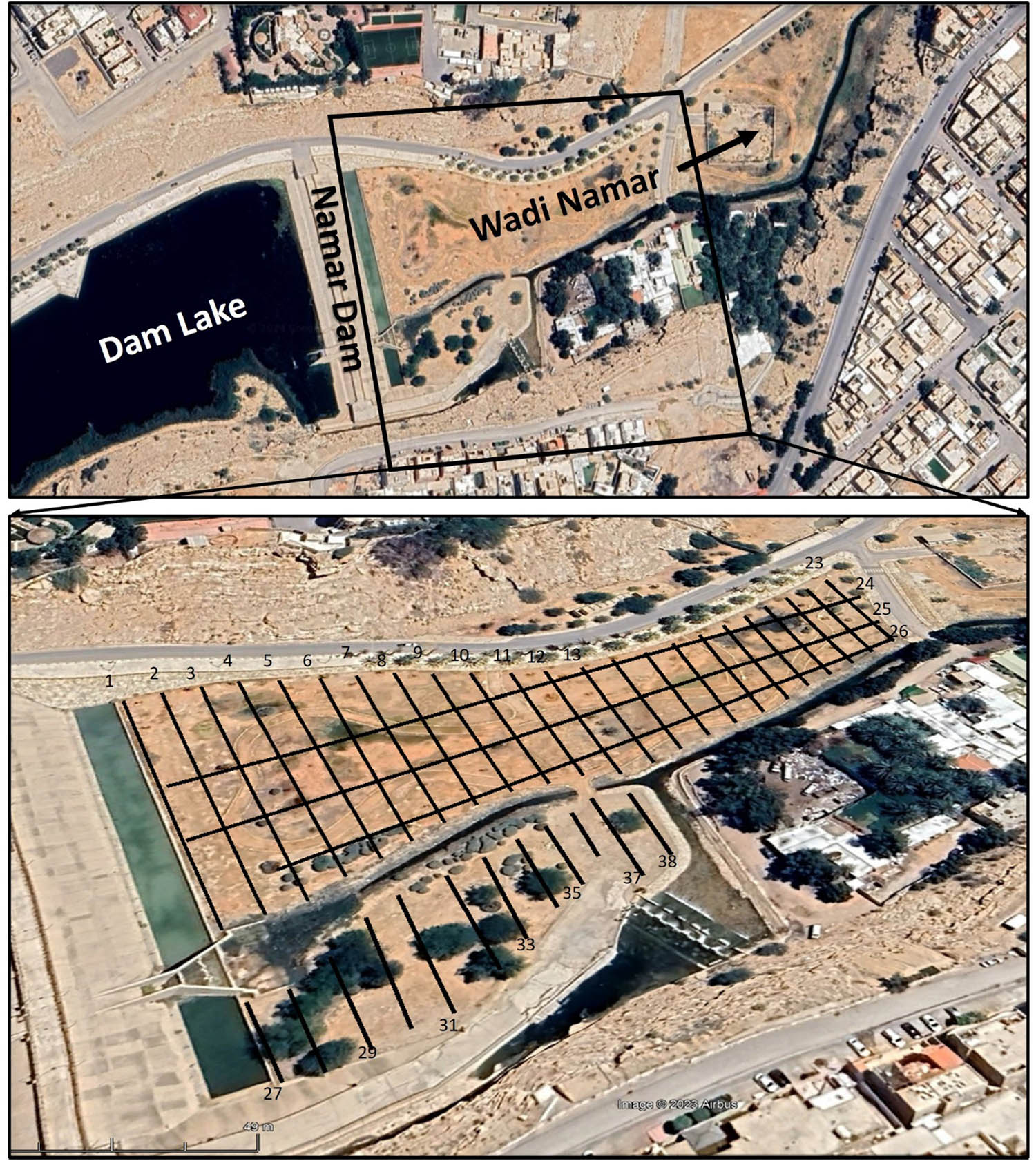
A satellite image showing the Wadi Namar dam and its upstream lake (top) and the location of the GPR survey lines (bottom).
4 GPR data processing
The general objective of GPR signal processing is to produce a readily interpreted image. GPR data often contain noise or interference, which makes data interpretation difficult. Therefore, the raw data are processed using different steps to clean up the noise, making it easier to visualize and interpret. Data processing was conducted using REFLEXW 7.0 software [44], and a series of frequency filters were applied to the GPR sections. The typical sequence of processing steps applied to the collected field data is as follows:
Apply subtract-mean (de-wow): This process involves temporal filtering to remove very low-frequency components (de-wowing) from the data. The filter calculates a running mean value for each trace and subtracts it from the central value. This filter acts on each trace independently, with a running mean value calculated for every data point in each trace. As a filtering parameter, de-wowing is applied using a low-cut filter with a cut-off frequency set below the bandwidth of the recorded data.
Move start time (time cut), this filter acts on each trace independently to limit its duration to a pre-definable maximum time. Only the time range is reduced to a preset interval. For our data, we applied a maximum time of 9–10 ns to obtain better resolution for the surface layer.
Adjusting the gain filter: Through this process, energy decay gain is applied, where a gain curve in the y (time) direction is used for each profile, based on the mean amplitude decay curve. First, a mean decay curve is calculated from all existing traces. After applying a median filter to this curve, every data point of each trace is divided by the corresponding values of the decay curve.
Background removal: In this stage, antenna ringing and horizontal banding across the image are eliminated by applying the background removal filter to the average of all accumulated scans. This processing step enables effective radar image enhancement. In addition to removing banding and ringing effects, background removal can eliminate other horizontal features, such as flat geological layers and planar reflections. Special care was taken when applying this filter to ensure optimal results.
Band pass filter: In the frequency domain, this filter has an independent effect on every trace. A cosine taper was selected from among the three available bandpass filtering types. Four frequency values are specified to define the filter band for the cosine taper. The low-cut frequency is determined by the first point, and the beginning of the lower plateau by the second. A cosine window defines the filter between the low-cut frequency and the start of the plateau. The end of the plateau is determined by the third point, while the high-cut frequency is determined by the fourth. A cosine window defines the filter between these points. The frequency spectrum is reduced to zero above the high-cut frequency and below the low-cut frequency. Either a low-pass filter or a high-pass filter can be achieved approximately by selecting the appropriate bandpass positions. Unwanted reverberations from the filter operator are suppressed using the cosine taper. The spectral amplitudes present at the high- and low-cut frequencies should be taken into account while adjusting the cosine range. The cosine range can be reduced if the spectral amplitudes are very small. When the frequency content of the noise differs from that of the signal, it can be suppressed using the bandpass filter.
Subtracting average: The filter subtracts the average of a predetermined number of traces at each time step. Horizontally coherent energy is suppressed by the filter through a process known as sliding background removal. Its effect is to enhance signals that vary laterally, such as diffractions.
Finally, the average x–y filter was applied: The average in this filter is calculated over a number of samples (y) as well as a number of traces (x). A smooth average of arrival times from the GPR signals is achieved by centering the filter area on the current data point. The start time of each trace is determined by its beginning time, and the end time by its maximum duration. For the average x–y filter, we set the number of traces to be averaged to eight and the number of samples to four.
During GPR data analysis, the GPR propagation velocity within limestone rocks is found to range between 0.099 and 0.159 m/ns [45] for karstified limestone. Therefore, to interpret the present GPR data, a velocity value of 0.13 m/ns is used, which is reasonable for delineating the subsurface structure. Previous studies have confirmed that the velocity value for limestone ranges from 0.09 to 0.15 m/ns [45–47].
5 Results and discussion
A variety of geophysical techniques are employed to understand subsurface hydrogeology [48–52]. The GPR method is applicable to shallow hydrogeological investigations; therefore, this method was used in the present study to investigate the geological parameters that could affect groundwater flow beneath the dam site. GPR sections (Figure 5) indicate GPR reflection signals related to vertical fractures that affect the Jubaila carbonate bedrock. The higher intensity of GPR reflections along these fractures may indicate wet fractures contaminated with fine clays (Arifin et al. [53]). GPR reflections caused by fracture planes are enhanced when the fractures are fluid-filled [42,54,55] due to the strong contrast in electrical properties between the fracture filling and the surrounding rock matrix [56,57]. The clearest examples are visible along GPR sections 2, 3, and 6 (Figure 5); however, there are other examples throughout the study area, such as GPR sections 11, 16, and 21 (Figure 6), which reveal wide vertical anomaly zones interpreted as vertical fracture zones extending to different depths, exceeding 5 m. These vertical fracture zones are characterized by high-amplitude reflections and a vertical pattern (Figure 6), implying zones of fractured carbonate rocks with high moisture content. This observation suggests that fractures and cracks may be interconnected, making the subsurface carbonate rock matrix more permeable and facilitating the vertical infiltration of groundwater in the study area. Similar fracture zones are observed in nearby surface exposures (Figure 7).

Representative examples of GPR sections across lines 2, 3, and 6, acquired with the use of the 400 MHz shielded antenna (black arrows indicate fracture structures).

GPR sections along lines 11, 16, and 21 indicating fractured wet zones.
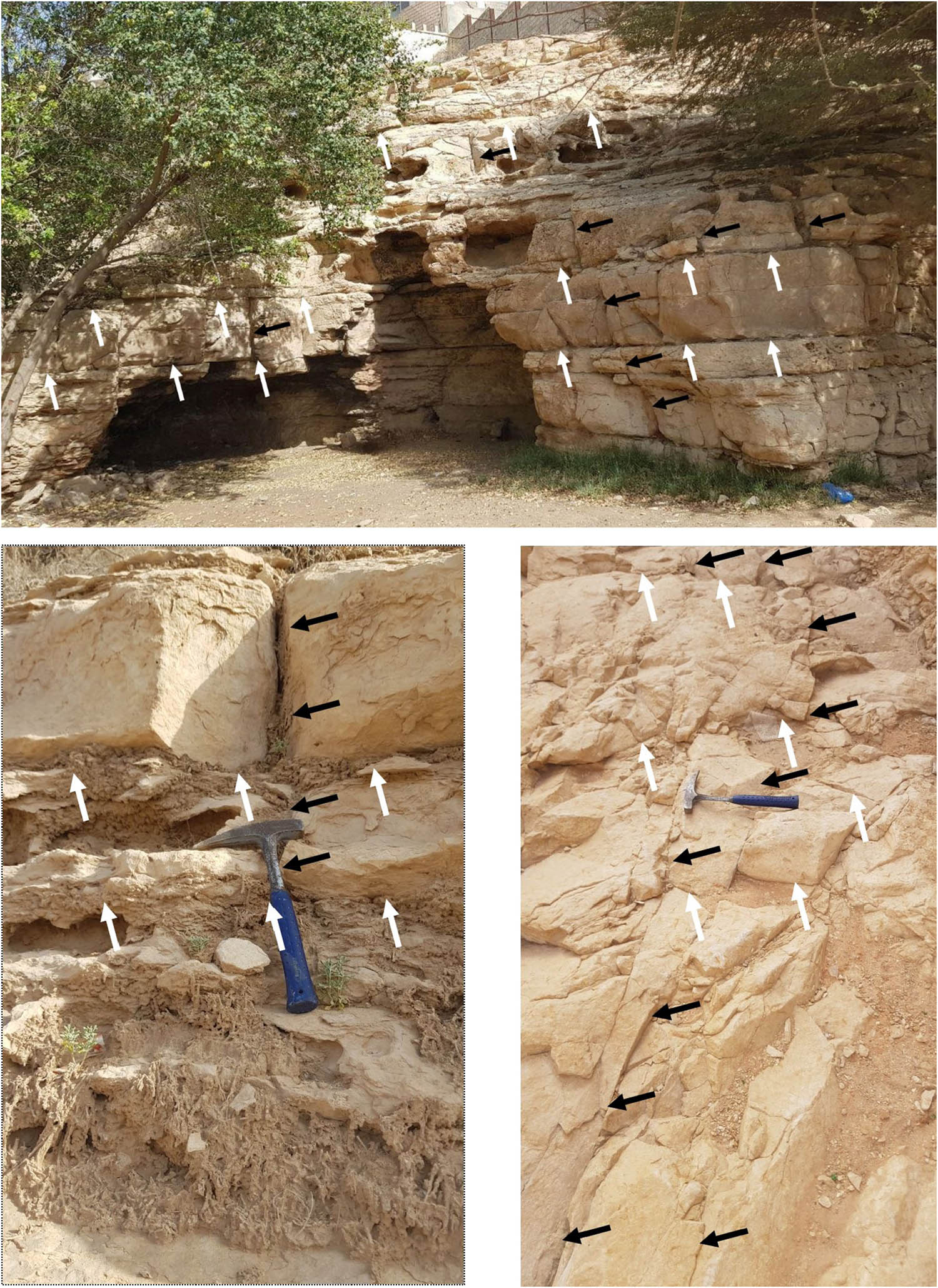
Field photograph showing the vertical (denoted by black arrows) and sheet-like fractures (denoted by white arrows) that dissected the Jubaila carbonate rocks around the Namar dam.
The GPR sections (Figure 8) indicate the presence of parallel sheet-like fracture sets that form horizontal lineaments. In Figure 8, horizontal reflectors at depths of 0.5 and 2.5 m are interpreted as sheet-like fractures similar to those observed in nearby surface exposures (Figure 9). The presence of sheet-like fractures as horizontal lineaments enables the lateral migration of water from the saturated lineaments. These sheet-like fractures could act as potential groundwater reservoirs that may extend laterally over considerable distances; therefore, groundwater can flow horizontally in many directions, depending on the geometry of these sheet fractures. Understanding this fracturing system is critical for an accurate assessment of groundwater flow in the study area. Furthermore, the identification of such laterally continuous karstic fractures may act as groundwater flow conduits and could impact the problem of groundwater rising at the dam site. It is evident from GPR sections 1, 2, 4, and 11 (Figure 8) that sheet-like fractures have affected the Jubaila carbonate formation, as confirmed by surface geological exposures (Figures 7 and 9). It is expected that the interpreted vertical and sheet-like fracture networks are the main groundwater conduits within the Jubaila carbonate rocks at the dam site. Additionally, when examining the general outline of the studied GPR sections (Figure 8), high-amplitude horizontal reflections appear disconnected in some places at different distances and depths, possibly indicating the dissection of the sheet fractures by vertical fractures or the presence of weathered zones in the Jubaila carbonate rock.

GPR sections along lines 1, 2, 4, and 11; black arrows indicate sheet-like fractures.
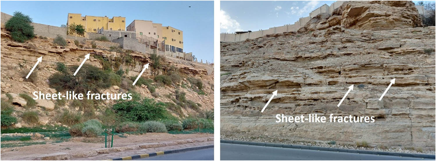
Field photograph showing the sheet-like fractures that dissected the Jubaila carbonate formation.
In some areas, GPR sections show high-resolution and clear GPR signals indicating the existence of dissolution karstic structures, which extend vertically and horizontally (Figure 10). The interpreted dissolution cavities on GPR sections are marked by disruptions in the strong GPR reflectors, possibly indicating the dissection of the interpreted karst cavities by vertical fracturing, similar to those observed in nearby surface exposures (Figure 11). In certain GPR sections (Figure 10), GPR reflections reveal the lateral and vertical distribution of karst dissolution features, which are connected to vertical and horizontal sheet fracturing zones. These GPR sections (Figure 10) display repeated hyperbolic reflections, suggesting possible karstic cavities with vertical fractures serving as conduits to facilitate groundwater ascension. Figure 10 shows examples of GPR signals with a symmetric hyperbolic shape and relatively strong amplitude, indicating carbonate dissolution cavities. For example, GPR profiles 23 and 26 (Figure 10) show a relatively strong hyperbolic GPR reflector around distances of 20 m and 100 m, at depths extending from 1 to 3 m.

GPR sections along lines 1, 23, and 26 indicating reflections from karst cavity structures.
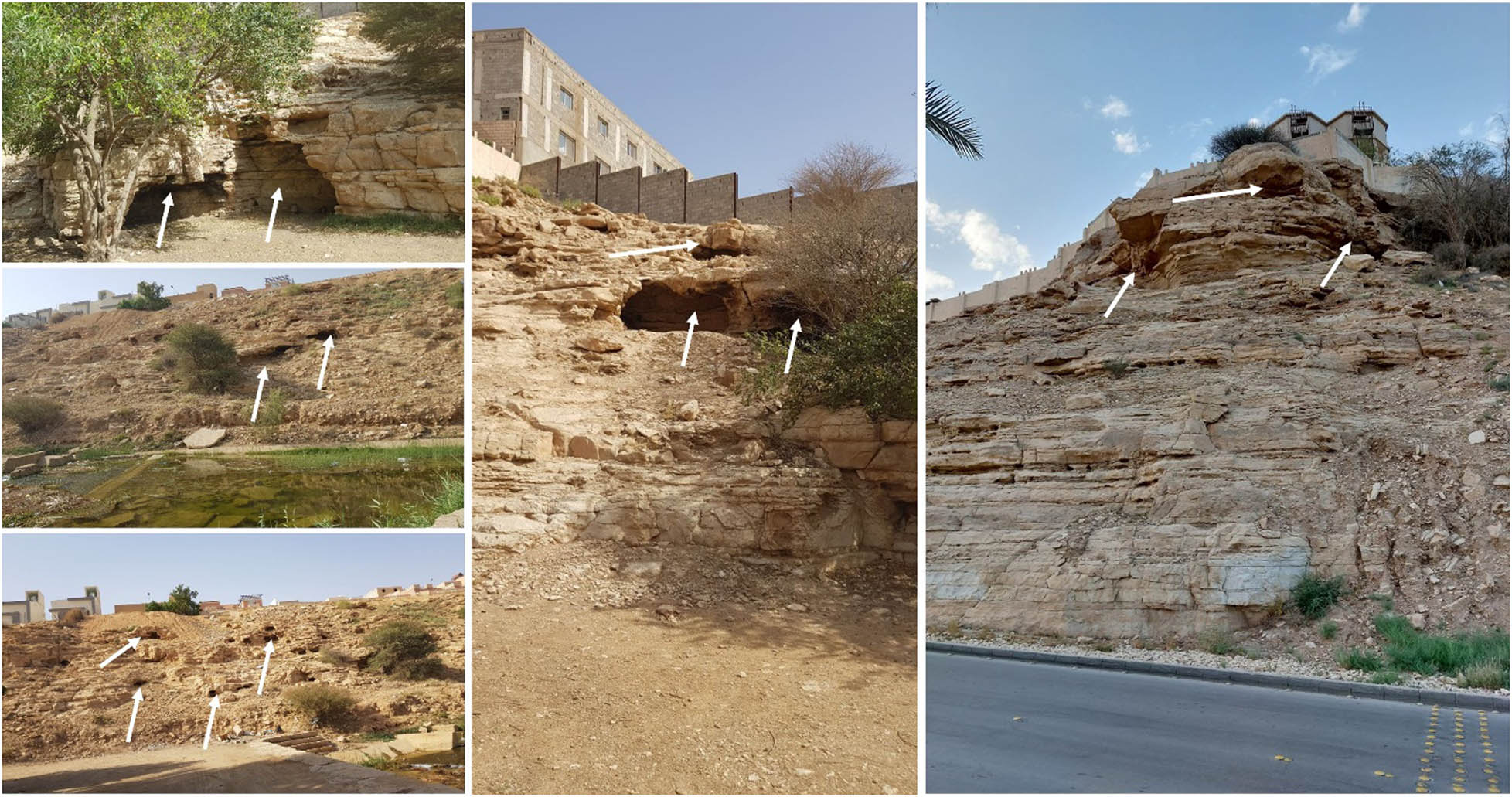
Field photograph showing the dominant cavity karst features in the Jubaila carbonate rocks (white arrow denotes cavity karst features).
6 Conclusion
The findings obtained through the analysis of the GPR sections underscore the effectiveness of this method in delineating subsurface geological structures that could contribute to water seepage issues in dams. The examination of GPR sections downstream of the Namar dam revealed a substrate of fractured and karstified carbonate rocks characterized by cavities, voids, and discontinuous fractures. These observations suggest that the carbonate bedrock underlying the dam lake floor is susceptible to dissolution by chemically aggressive water, leading to increased secondary porosity along fractures and joints, potentially forming conduits for groundwater flow.
Various abnormal features, including cavities, voids, and fractures, were identified along the GPR sections within the Jubaila limestone bedrock. These karst features appear to be significant factors contributing to leakage at the Namar dam, with water seepage from the dam lake posing a notable challenge at the site. Furthermore, the successful application of GPR imaging highlights its efficacy in mapping subsurface structures and delineating potential pathways for groundwater flow, making it an invaluable tool in hydrogeological investigations.
Further research and monitoring efforts are essential to enhance our understanding of subsurface hydrogeological dynamics in karstic terrains. The ongoing utilization of advanced geophysical techniques, in conjunction with geological studies, will play a pivotal role in devising comprehensive strategies for managing water resources and safeguarding critical infrastructure.
Acknowledgments
This research was supported by Researchers Supporting Project number (RSP2025R496), King Saud University, Riyadh, Saudi Arabia.
-
Funding information: This research was supported by Researchers Supporting Project number (RSP2025R496), King Saud University, Riyadh, Saudi Arabia.
-
Author contributions: All authors have accepted responsibility for the entire content of this manuscript and consented to its submission to the journal. SSA and EH wrote the draft of the manuscript. SSA, EH, and KA reviewed, edited the manuscript and approved the final version of the manuscript. SSA paid APC and collected the field data.
-
Conflict of interest: Authors state no conflict of interest.
References
[1] Fnais MS. Geophysical characteristics of Wadi Hanifah water system, Riyadh, Saudi Arabia. Arab J Geosci. 2011;4:1051–66. 10.1007/s12517-009-0104-7.Search in Google Scholar
[2] Amin AA, Bankher KA. Karst Hazard assessment of Eastern Saudi Arabia. Nat Hazards. 1997;15(21–30):21–30. 10.1023/A:1007918623324.Search in Google Scholar
[3] Touma FT, Bellerjeau WR. Experience with foundations of structures on rock in Saudi Arabia. Symp. on Geotechnical Problems in Saudi Arabia, v. Ia; 1981. p. 49.Search in Google Scholar
[4] Vaslet D, Al Muallem MS, Madah SS, Shorbaji H. Preliminary technical investigation of a crevasse opened at Al Kharj end of February 1988: Ministry of Petroleum and Minerals Report, BRGM-JED-IR-88-1, p. 10.Search in Google Scholar
[5] Blyth FGH, De Freitas MH. A geology for engineers. 7th edn. London: Edward Arnold Pub; 1978. p. 1–325.Search in Google Scholar
[6] Tabwassah CA, Obiefuna GI. Geophysical and geotechnical investigation of Cham Failed Dam Project, Ne Nigeria. Res J Recent Sci. 2012;1(2):2277–502.Search in Google Scholar
[7] Martin JB, Screaton EJ. Exchange of Matrix and Conduit Water with Examples from the Floridan Aquifer: U.S. Geological Survey Karst Interest Group Proceedings, Water Resources Investigations Report 01–4011; 2001. p. 38–44.Search in Google Scholar
[8] Donnelly CR, Hinchberger S, Mohammadain E. The design of foundation treatment measures for dams on karst foundations. Can Dam Assoc Bull. 2009;20(4):20–7.Search in Google Scholar
[9] Gutiérrez F, Parise M, De Waele J, Jourde H. A review on natural and human-induced geohazards and impacts in karst. Earth-Sci Rev. 2014;138:61–88.10.1016/j.earscirev.2014.08.002Search in Google Scholar
[10] Parise M, Closson D, Gutierrez F, Stevanovic Z, editors. Facing engineering problems in the fragile karst environment. In: Lollino G, Manconi A, Guzzetti F, Culshaw M, Bobrowsky P, Luino F. Engineering geology for society and territory. Volume 5—Urban geology, sustainable planning and landscape exploitation. Switzerland: Springer International Publishing; 2014. p. 479–82.Search in Google Scholar
[11] Palma B, Ruocco A, Lollino P, Parise M. Analysis of the behaviour of a carbonate rock mass due to tunneling in a karst setting. In: Han KC, Park C, Kim JD, Jeon S & Song JJ (Eds.), The present and future of rock engineering. Proceedings 7th Asian Rock Mechanics Symposium, October 15-19, Seoul. 2012. p. 772-81.Search in Google Scholar
[12] Milanović PT. Water resources engineering in Karst. Boca Raton, FL: CRC Press; 2004. p. 312.Search in Google Scholar
[13] Paterson K. Limestone springs in the Oxfordshire Scarplands: The significance of spatial and temporal variations in their chemistry. Vol. 32, Stuttgart-Germany: Zeitschrift für Geomorphologie; 1979. p. 46–66.Search in Google Scholar
[14] Pitty AF. Calcium carbonate content of karst water in relation to flow-through time. Nature. 1968;217:939–40.10.1038/217939a0Search in Google Scholar
[15] Mellor C, Hubbard P, Douglas TJ, Worley B. A Detailed Geophysical Survey to Characterize Subsurface Failures on Interstate 40, Pender County, North Carolina. 2025. dot.state.fl.us/./materials/mellor-hubbarddouglas- worley.pdf.Search in Google Scholar
[16] Alhumimidi MS, Harbi HM, Alfarhan MS, Abdelrahman K, Aiken CLV. Imaging fracture distributions of the Al-Khuff Formation outcrops using GPR and ERT geophysical techniques, Al-Qassim area, Saudi Arabia. Arab J Geosci. 2017;10:306.10.1007/s12517-017-3059-0Search in Google Scholar
[17] Almadani S, Ibrahim E, Hafez M, Alfaifi H, Alharbi T, Abdelrahman K, et al. Geotechnical investigation of the El-Elb dam site, northwest Riyadh,Saudi Arabia, using 2D resistivity and ground-penetrating radar techniques. Arab J Geosci. 2018;11:33.10.1007/s12517-017-3353-xSearch in Google Scholar
[18] Romano G, De Girolamo M, Parise M. Geophysical researches to detect karst caves in the main polje of Apulia. In: Andreo B, Barberà JA, Duràn-Valsero JJ, Gil-Marquez JM, Mudarra M, editors. Eurokarst (2022). Malaga. Advances in Karst Science. Cham, Switzerland: Springer; 2023. p. 153–8.10.1007/978-3-031-16879-6_22Search in Google Scholar
[19] Romano G, Capozzoli L, Abate N, De Girolamo M, Liso IS, Patella D, et al. An integrated geophysical and UNMANNED Aerial Systems surveys for multi-sensory, multi-scale and multi-resolution cave detection: The Gravaglione site (Canale di Pirro Polje, Apulia. Remote Sens. 2023;15:3820. 10.3390/rs15153820.Search in Google Scholar
[20] Abdeltawab S. Karst limestone geohazards in Egypt and Saudi Arabia. Int J Geoeng Case Hist. 2013;2:258–69.Search in Google Scholar
[21] Alfy ME, Lashin A, Faraj T, Alataway A, Tarawneh Q, Al-Bassam A. Quantitative hydro-geophysical analysis of a complex structural karst aquifer in Eastern Saudi Arabia. Sci Rep. 2019;9:2825. 10.1038/s41598-019-39192-4.Search in Google Scholar PubMed PubMed Central
[22] Youssef AM, Al-Harbi HM, Gutiérrez F, Zabramwi YA, Bulkhi AB, Zahrani SA, et al. Natural and human-induced sinkhole hazards in Saudi Arabia: Distribution, investigation, causes and impacts. Hydrogeol J. 2016;24:625–44.10.1007/s10040-015-1336-0Search in Google Scholar
[23] Abd El-Aal AK. Geomechanical aspects and suitability of the limestone (Sulaiy Limestone Formation) for Foundation Bedrock, Sulaiy Region, Saudi. Arabia J Geol Geophys. 2015;4:1–5.Search in Google Scholar
[24] Abd El-Aal A. Identification and characterization of near surface cavities in Tuwaiq Mountain Limestone, Riyadh, KSA, “detection and treatment”. Egypt J Pet. 2017;26:215–23.10.1016/j.ejpe.2016.04.004Search in Google Scholar
[25] Cueto M, Olona J, Fernández‐Viejo G, Pando L, López‐Fernández C. Karst-induced sinkhole detection using an integrated geophysical survey: A case study along the Riyadh Metro Line 3 (Saudi Arabia). Surf Geophysics. 2018;16:270–81.10.3997/1873-0604.2018003Search in Google Scholar
[26] Powers RW. Lexique Stratigraphique International, v.III, Asie, 10bl, Saudi Arabia. Paris: Centre National de la Recherche Scientifique; 1968. p. 177.Search in Google Scholar
[27] Powers RW, Ramirez LF, Redmond CD, Elberg EL. Geology of the Arabian Peninsula, Geological Survey Professional Paper, 560-D, 1966. p. 147.Search in Google Scholar
[28] Ford DC, Ewers RO. The development of limestone cave systems in the dimensions of length and depth. Can J Earth Sci. 1978;15:1783–98.10.1139/e78-186Search in Google Scholar
[29] Palmer AN. Origin and morphology of limestone caves. Geol Soc Am Bull. 1991;103:1–21.10.1130/0016-7606(1991)103<0001:OAMOLC>2.3.CO;2Search in Google Scholar
[30] Sweeting MM. Erosion cycles and limestone caverns in the Ingleborough District (England). J Geol. 1950;115:63–78.10.2307/1789020Search in Google Scholar
[31] Swinnerton AC. Origin of limestone caverns. Geol Soc Am Bull. 1932;43:663–94.10.1130/GSAB-43-663Search in Google Scholar
[32] Al-Sayari SS, Zötl JG. Quaternary Period in Saudi Arabia. 1: Sedimentological, Hydrogeological, Hydrochemical, Geomorphological and Climatological Investigations in Central and Eastern Saudi Arabia. XI, 335 S., Vienna/New York. Berlin: Springer; 1978. 10.1007/978-3-7091-8494-3.Search in Google Scholar
[33] Jado A, Johnson D. Solution caverns in the Dammam Dome, Dhahran, Saudi-Arabia. Arab J Sci & Eng. 1983;8:69–73.Search in Google Scholar
[34] Samouëlian A, Cousin I, Tabbagh A, Bruand A, Richard G. Electrical resistivity survey in soil science: A review. Soil Tillage Res. 2005;83:173–93.10.1016/j.still.2004.10.004Search in Google Scholar
[35] Bermejo L, Ortega AI, Parés JM, Campaña I, Bermúdez de Castro JM, Carbonell E, et al. Karst features interpretation using groundpenetrating radar: A case study from the Sierra de Atapuerca, Spain. Geomorphology. 2020;367:107311. 10.1016/j.geomorph.2020.107311.Search in Google Scholar
[36] Carpenter P, Ekberg D. Identification of buried sinkholes, fractures and soil pipes using ground-penetrating radar and 2D electrical resistivity tomography. Proceedings of the Highway Geophysics-NDE Conference, Saint Louis, MI, USA, 4–7 December 2006; 2006. p. 437–49.Search in Google Scholar
[37] Caselle C, Bonetto S, Comina C, Stocco S. GPR surveys for the prevention of karst risk in underground gypsum quarries. Tunn Undergr Space Technol. 2020;95:103–37. 10.1016/j.tust.2019.103137.Search in Google Scholar
[38] Kruse S, Grasmueck M, Weiss M, Viggiano D. Sinkhole structure imaging in covered karst terrain. Geophys Res Lett. 2006;33:33.10.1029/2006GL026975Search in Google Scholar
[39] Van Schoor M. Detection of sinkholes using 2D electrical resistivity imaging. J Appl Geophysics. 2002;50:393–9.10.1016/S0926-9851(02)00166-0Search in Google Scholar
[40] Anchuela ÓP, Casas-Sainz AM, Soriano MA, Pocoví-Juan A. Mapping subsurface karst features with GPR: Results and limitations. Env Geol. 2009;58:391–9. 10.1007/s00254-008-1603-7.Search in Google Scholar
[41] Deparis J, Garambois S. On the use of dispersive APVO GPR curves for thin bed properties estimation: Theory and application to fracture characterization. Geophysics. 2009;74(1):J1–12. 10.1190/1.3008545.Search in Google Scholar
[42] Tsoflias GP, Hoch A. Investigating multi-polarization GPR wave transmission through thin layers: Implications for vertical fracture characterization. Geophys Res Lett. 2006;33(20):L20401. 10.1029/2006GL027788.Search in Google Scholar
[43] Tsoflias GP, Van Gestel J-P, Stoffa PL, Blankenship DD, Sen M. Vertical fracture detection by exploiting the polarization properties of ground-penetrating radar signals. Geophysics. 2004;69(3):803–10. 10.1190/1.1759466.Search in Google Scholar
[44] Sandmeier KJ. REFLEXW software (version 7.2.3): A windows program for the processing and interpretation of reflection and transmission data 2015.Search in Google Scholar
[45] Annan AP. Ground Penetrating Radar Workshop Notes. Ontario, Canada: Sensors & Software; 2001.Search in Google Scholar
[46] OYO. OYO Georadar I Manual. Tsukuba, Japan: OYO Corporation; 1988.Search in Google Scholar
[47] Reynolds JM. An introduction to applied and environmental geophysics. England: John Wiley & Sons; 1997.Search in Google Scholar
[48] Gilbert R. A handbook of geophysical techniques for geomorphic and environmental research. Geological Survey of Canada; 1999. pp. 125.10.4095/210367Search in Google Scholar
[49] Houcyne E, Idrysy E, De Smedt F. A geostatistical methodology to estimate the base of the Trifa aquifer (Morocco) with limited drilling and geo-electrical sounding data. Bull Eng Geol Env. 2004;63:345–51. 10.1007/s1006 4-004-0249-2.Search in Google Scholar
[50] Binley A, Hubbard SS, Huisman JA, Revil A, Robinson DA, Singha K, et al. The emergence of hydrogeophysics for improved understanding of subsurface processes over multiple scales. Water Resour Res. 2015;51:3837–66.10.1002/2015WR017016Search in Google Scholar PubMed PubMed Central
[51] Gulbrandsen ML, Ball LB, Minsley BJ, Hansen TM. Automatic mapping of the base of aquifer—a case study from Morrill, Nebraska. Interpretation. 2017;5:T231–41. 10.1190/INT-2016-0195.1.Search in Google Scholar
[52] Gómez E, Larsson M, Dahlin T, Barmen G, Rosberg JE. Alluvial aquifer thickness and bedrock structure delineation by electromagnetic methods in the highlands of Bolivia. Env Earth Sci. 2019;78:84. 10.1007/s1266 5-019-8074-x.Search in Google Scholar
[53] Arifin MH, Jamaluddin TA, Husin H, Ismail A, Abbas AA, Nordin MN, et al. Comparison of geological mapping with electrical resistivity and ground penetration radar methods for rock fractured system study. Chiang Mai J Sci. 2016;43(6):1346–57.Search in Google Scholar
[54] Shakas A, Linde N. Apparent apertures from ground penetrating radar data and their relation to heterogeneous aperture fields. Geophys J Int. 2017;209(3):1418–30. 10.1093/gji/ggx100.Search in Google Scholar
[55] Tsoflias GP, Becker MW. Ground-penetrating-radar response to fracture-fluid salinity: Why lower frequencies are favorable for resolving salinity changes. Geophysics. 2008;73(5):J25–30. 10.1190/1.2957893.Search in Google Scholar
[56] Bradford JH, Deeds JC. Ground-penetrating radar theory and application of thin-bed offset-dependent reflectivity. Geophysics. 2006;71(3):K47–57. 10.1190/1.2194524.Search in Google Scholar
[57] Shakas A, Linde N. Effective modeling of ground penetrating radar in fractured media using analytic solutions for propagation, thin-bed interaction and dipolar scattering. J Appl Geophysics. 2015;116:206–14. 10.1016/j.jappgeo.2015.03.018.Search in Google Scholar
© 2025 the author(s), published by De Gruyter
This work is licensed under the Creative Commons Attribution 4.0 International License.
Articles in the same Issue
- Research Articles
- Seismic response and damage model analysis of rocky slopes with weak interlayers
- Multi-scenario simulation and eco-environmental effect analysis of “Production–Living–Ecological space” based on PLUS model: A case study of Anyang City
- Remote sensing estimation of chlorophyll content in rape leaves in Weibei dryland region of China
- GIS-based frequency ratio and Shannon entropy modeling for landslide susceptibility mapping: A case study in Kundah Taluk, Nilgiris District, India
- Natural gas origin and accumulation of the Changxing–Feixianguan Formation in the Puguang area, China
- Spatial variations of shear-wave velocity anomaly derived from Love wave ambient noise seismic tomography along Lembang Fault (West Java, Indonesia)
- Evaluation of cumulative rainfall and rainfall event–duration threshold based on triggering and non-triggering rainfalls: Northern Thailand case
- Pixel and region-oriented classification of Sentinel-2 imagery to assess LULC dynamics and their climate impact in Nowshera, Pakistan
- The use of radar-optical remote sensing data and geographic information system–analytical hierarchy process–multicriteria decision analysis techniques for revealing groundwater recharge prospective zones in arid-semi arid lands
- Effect of pore throats on the reservoir quality of tight sandstone: A case study of the Yanchang Formation in the Zhidan area, Ordos Basin
- Hydroelectric simulation of the phreatic water response of mining cracked soil based on microbial solidification
- Spatial-temporal evolution of habitat quality in tropical monsoon climate region based on “pattern–process–quality” – a case study of Cambodia
- Early Permian to Middle Triassic Formation petroleum potentials of Sydney Basin, Australia: A geochemical analysis
- Micro-mechanism analysis of Zhongchuan loess liquefaction disaster induced by Jishishan M6.2 earthquake in 2023
- Prediction method of S-wave velocities in tight sandstone reservoirs – a case study of CO2 geological storage area in Ordos Basin
- Ecological restoration in valley area of semiarid region damaged by shallow buried coal seam mining
- Hydrocarbon-generating characteristics of Xujiahe coal-bearing source rocks in the continuous sedimentary environment of the Southwest Sichuan
- Hazard analysis of future surface displacements on active faults based on the recurrence interval of strong earthquakes
- Structural characterization of the Zalm district, West Saudi Arabia, using aeromagnetic data: An approach for gold mineral exploration
- Research on the variation in the Shields curve of silt initiation
- Reuse of agricultural drainage water and wastewater for crop irrigation in southeastern Algeria
- Assessing the effectiveness of utilizing low-cost inertial measurement unit sensors for producing as-built plans
- Analysis of the formation process of a natural fertilizer in the loess area
- Machine learning methods for landslide mapping studies: A comparative study of SVM and RF algorithms in the Oued Aoulai watershed (Morocco)
- Chemical dissolution and the source of salt efflorescence in weathering of sandstone cultural relics
- Molecular simulation of methane adsorption capacity in transitional shale – a case study of Longtan Formation shale in Southern Sichuan Basin, SW China
- Evolution characteristics of extreme maximum temperature events in Central China and adaptation strategies under different future warming scenarios
- Estimating Bowen ratio in local environment based on satellite imagery
- 3D fusion modeling of multi-scale geological structures based on subdivision-NURBS surfaces and stratigraphic sequence formalization
- Comparative analysis of machine learning algorithms in Google Earth Engine for urban land use dynamics in rapidly urbanizing South Asian cities
- Study on the mechanism of plant root influence on soil properties in expansive soil areas
- Simulation of seismic hazard parameters and earthquakes source mechanisms along the Red Sea rift, western Saudi Arabia
- Tectonics vs sedimentation in foredeep basins: A tale from the Oligo-Miocene Monte Falterona Formation (Northern Apennines, Italy)
- Investigation of landslide areas in Tokat-Almus road between Bakımlı-Almus by the PS-InSAR method (Türkiye)
- Predicting coastal variations in non-storm conditions with machine learning
- Cross-dimensional adaptivity research on a 3D earth observation data cube model
- Geochronology and geochemistry of late Paleozoic volcanic rocks in eastern Inner Mongolia and their geological significance
- Spatial and temporal evolution of land use and habitat quality in arid regions – a case of Northwest China
- Ground-penetrating radar imaging of subsurface karst features controlling water leakage across Wadi Namar dam, south Riyadh, Saudi Arabia
- Rayleigh wave dispersion inversion via modified sine cosine algorithm: Application to Hangzhou, China passive surface wave data
- Fractal insights into permeability control by pore structure in tight sandstone reservoirs, Heshui area, Ordos Basin
- Debris flow hazard characteristic and mitigation in Yusitong Gully, Hengduan Mountainous Region
- Research on community characteristics of vegetation restoration in hilly power engineering based on multi temporal remote sensing technology
- Identification of radial drainage networks based on topographic and geometric features
- Trace elements and melt inclusion in zircon within the Qunji porphyry Cu deposit: Application to the metallogenic potential of the reduced magma-hydrothermal system
- Pore, fracture characteristics and diagenetic evolution of medium-maturity marine shales from the Silurian Longmaxi Formation, NE Sichuan Basin, China
- Study of the earthquakes source parameters, site response, and path attenuation using P and S-waves spectral inversion, Aswan region, south Egypt
- Source of contamination and assessment of potential health risks of potentially toxic metal(loid)s in agricultural soil from Al Lith, Saudi Arabia
- Regional spatiotemporal evolution and influencing factors of rural construction areas in the Nanxi River Basin via GIS
- An efficient network for object detection in scale-imbalanced remote sensing images
- Effect of microscopic pore–throat structure heterogeneity on waterflooding seepage characteristics of tight sandstone reservoirs
- Environmental health risk assessment of Zn, Cd, Pb, Fe, and Co in coastal sediments of the southeastern Gulf of Aqaba
- A modified Hoek–Brown model considering softening effects and its applications
- Evaluation of engineering properties of soil for sustainable urban development
- The spatio-temporal characteristics and influencing factors of sustainable development in China’s provincial areas
- Application of a mixed additive and multiplicative random error model to generate DTM products from LiDAR data
- Gold vein mineralogy and oxygen isotopes of Wadi Abu Khusheiba, Jordan
- Prediction of surface deformation time series in closed mines based on LSTM and optimization algorithms
- 2D–3D Geological features collaborative identification of surrounding rock structural planes in hydraulic adit based on OC-AINet
- Spatiotemporal patterns and drivers of Chl-a in Chinese lakes between 1986 and 2023
- Land use classification through fusion of remote sensing images and multi-source data
- Nexus between renewable energy, technological innovation, and carbon dioxide emissions in Saudi Arabia
- Analysis of the spillover effects of green organic transformation on sustainable development in ethnic regions’ agriculture and animal husbandry
- Factors impacting spatial distribution of black and odorous water bodies in Hebei
- Large-scale shaking table tests on the liquefaction and deformation responses of an ultra-deep overburden
- Impacts of climate change and sea-level rise on the coastal geological environment of Quang Nam province, Vietnam
- Reservoir characterization and exploration potential of shale reservoir near denudation area: A case study of Ordovician–Silurian marine shale, China
- Seismic prediction of Permian volcanic rock reservoirs in Southwest Sichuan Basin
- Application of CBERS-04 IRS data to land surface temperature inversion: A case study based on Minqin arid area
- Geological characteristics and prospecting direction of Sanjiaoding gold mine in Saishiteng area
- Research on the deformation prediction model of surrounding rock based on SSA-VMD-GRU
- Geochronology, geochemical characteristics, and tectonic significance of the granites, Menghewula, Southern Great Xing’an range
- Hazard classification of active faults in Yunnan base on probabilistic seismic hazard assessment
- Characteristics analysis of hydrate reservoirs with different geological structures developed by vertical well depressurization
- Estimating the travel distance of channelized rock avalanches using genetic programming method
- Landscape preferences of hikers in Three Parallel Rivers Region and its adjacent regions by content analysis of user-generated photography
- New age constraints of the LGM onset in the Bohemian Forest – Central Europe
- Characteristics of geological evolution based on the multifractal singularity theory: A case study of Heyu granite and Mesozoic tectonics
- Soil water content and longitudinal microbiota distribution in disturbed areas of tower foundations of power transmission and transformation projects
- Oil accumulation process of the Kongdian reservoir in the deep subsag zone of the Cangdong Sag, Bohai Bay Basin, China
- Investigation of velocity profile in rock–ice avalanche by particle image velocimetry measurement
- Optimizing 3D seismic survey geometries using ray tracing and illumination modeling: A case study from Penobscot field
- Sedimentology of the Phra That and Pha Daeng Formations: A preliminary evaluation of geological CO2 storage potential in the Lampang Basin, Thailand
- Improved classification algorithm for hyperspectral remote sensing images based on the hybrid spectral network model
- Map analysis of soil erodibility rates and gully erosion sites in Anambra State, South Eastern Nigeria
- Identification and driving mechanism of land use conflict in China’s South-North transition zone: A case study of Huaihe River Basin
- Evaluation of the impact of land-use change on earthquake risk distribution in different periods: An empirical analysis from Sichuan Province
- A test site case study on the long-term behavior of geotextile tubes
- An experimental investigation into carbon dioxide flooding and rock dissolution in low-permeability reservoirs of the South China Sea
- Detection and semi-quantitative analysis of naphthenic acids in coal and gangue from mining areas in China
- Comparative effects of olivine and sand on KOH-treated clayey soil
- YOLO-MC: An algorithm for early forest fire recognition based on drone image
- Earthquake building damage classification based on full suite of Sentinel-1 features
- Potential landslide detection and influencing factors analysis in the upper Yellow River based on SBAS-InSAR technology
- Assessing green area changes in Najran City, Saudi Arabia (2013–2022) using hybrid deep learning techniques
- An advanced approach integrating methods to estimate hydraulic conductivity of different soil types supported by a machine learning model
- Hybrid methods for land use and land cover classification using remote sensing and combined spectral feature extraction: A case study of Najran City, KSA
- Streamlining digital elevation model construction from historical aerial photographs: The impact of reference elevation data on spatial accuracy
- Analysis of urban expansion patterns in the Yangtze River Delta based on the fusion impervious surfaces dataset
- A metaverse-based visual analysis approach for 3D reservoir models
- Late Quaternary record of 100 ka depositional cycles on the Larache shelf (NW Morocco)
- Integrated well-seismic analysis of sedimentary facies distribution: A case study from the Mesoproterozoic, Ordos Basin, China
- Study on the spatial equilibrium of cultural and tourism resources in Macao, China
- Urban road surface condition detecting and integrating based on the mobile sensing framework with multi-modal sensors
- Application of improved sine cosine algorithm with chaotic mapping and novel updating methods for joint inversion of resistivity and surface wave data
- The synergistic use of AHP and GIS to assess factors driving forest fire potential in a peat swamp forest in Thailand
- Dynamic response analysis and comprehensive evaluation of cement-improved aeolian sand roadbed
- Rock control on evolution of Khorat Cuesta, Khorat UNESCO Geopark, Northeastern Thailand
- Gradient response mechanism of carbon storage: Spatiotemporal analysis of economic-ecological dimensions based on hybrid machine learning
- Comparison of several seismic active earth pressure calculation methods for retaining structures
- Mantle dynamics and petrogenesis of Gomer basalts in the Northwestern Ethiopia: A geochemical perspective
- Study on ground deformation monitoring in Xiong’an New Area from 2021 to 2023 based on DS-InSAR
- Paleoenvironmental characteristics of continental shale and its significance to organic matter enrichment: Taking the fifth member of Xujiahe Formation in Tianfu area of Sichuan Basin as an example
- Equipping the integral approach with generalized least squares to reconstruct relict channel profile and its usage in the Shanxi Rift, northern China
- InSAR-driven landslide hazard assessment along highways in hilly regions: A case-based validation approach
- Attribution analysis of multi-temporal scale surface streamflow changes in the Ganjiang River based on a multi-temporal Budyko framework
- Maps analysis of Najran City, Saudi Arabia to enhance agricultural development using hybrid system of ANN and multi-CNN models
- Hybrid deep learning with a random forest system for sustainable agricultural land cover classification using DEM in Najran, Saudi Arabia
- Long-term evolution patterns of groundwater depth and lagged response to precipitation in a complex aquifer system: Insights from Huaibei Region, China
- Remote sensing and machine learning for lithology and mineral detection in NW, Pakistan
- Spatial–temporal variations of NO2 pollution in Shandong Province based on Sentinel-5P satellite data and influencing factors
- Numerical modeling of geothermal energy piles with sensitivity and parameter variation analysis of a case study
- Stability analysis of valley-type upstream tailings dams using a 3D model
- Variation characteristics and attribution analysis of actual evaporation at monthly time scale from 1982 to 2019 in Jialing River Basin, China
- Investigating machine learning and statistical approaches for landslide susceptibility mapping in Minfeng County, Xinjiang
- Investigating spatiotemporal patterns for comprehensive accessibility of service facilities by location-based service data in Nanjing (2016–2022)
- A pre-treatment method for particle size analysis of fine-grained sedimentary rocks, Bohai Bay Basin, China
- Study on the formation mechanism of the hard-shell layer of liquefied silty soil
- Comprehensive analysis of agricultural CEE: Efficiency assessment, mechanism identification, and policy response – A case study of Anhui Province
- Simulation study on the damage and failure mechanism of the surrounding rock in sanded dolomite tunnels
- Towards carbon neutrality: Spatiotemporal evolution and key influences on agricultural ecological efficiency in Northwest China
- Review Articles
- Humic substances influence on the distribution of dissolved iron in seawater: A review of electrochemical methods and other techniques
- Applications of physics-informed neural networks in geosciences: From basic seismology to comprehensive environmental studies
- Ore-controlling structures of granite-related uranium deposits in South China: A review
- Shallow geological structure features in Balikpapan Bay East Kalimantan Province – Indonesia
- A review on the tectonic affinity of microcontinents and evolution of the Proto-Tethys Ocean in Northeastern Tibet
- Advancements in machine learning applications for mineral prospecting and geophysical inversion: A review
- Special Issue: Natural Resources and Environmental Risks: Towards a Sustainable Future - Part II
- Depopulation in the Visok micro-region: Toward demographic and economic revitalization
- Special Issue: Geospatial and Environmental Dynamics - Part II
- Advancing urban sustainability: Applying GIS technologies to assess SDG indicators – a case study of Podgorica (Montenegro)
- Spatiotemporal and trend analysis of common cancers in men in Central Serbia (1999–2021)
- Minerals for the green agenda, implications, stalemates, and alternatives
- Spatiotemporal water quality analysis of Vrana Lake, Croatia
- Functional transformation of settlements in coal exploitation zones: A case study of the municipality of Stanari in Republic of Srpska (Bosnia and Herzegovina)
- Hypertension in AP Vojvodina (Northern Serbia): A spatio-temporal analysis of patients at the Institute for Cardiovascular Diseases of Vojvodina
- Regional patterns in cause-specific mortality in Montenegro, 1991–2019
- Spatio-temporal analysis of flood events using GIS and remote sensing-based approach in the Ukrina River Basin, Bosnia and Herzegovina
- Flash flood susceptibility mapping using LiDAR-Derived DEM and machine learning algorithms: Ljuboviđa case study, Serbia
- Geocultural heritage as a basis for geotourism development: Banjska Monastery, Zvečan (Serbia)
- Assessment of groundwater potential zones using GIS and AHP techniques – A case study of the zone of influence of Kolubara Mining Basin
- Impact of the agri-geographical transformation of rural settlements on the geospatial dynamics of soil erosion intensity in municipalities of Central Serbia
- Where faith meets geomorphology: The cultural and religious significance of geodiversity explored through geospatial technologies
- Applications of local climate zone classification in European cities: A review of in situ and mobile monitoring methods in urban climate studies
- Complex multivariate water quality impact assessment on Krivaja River
- Ionization hotspots near waterfalls in Eastern Serbia’s Stara Planina Mountain
- Shift in landscape use strategies during the transition from the Bronze age to Iron age in Northwest Serbia
- Assessing the geotourism potential of glacial lakes in Plav, Montenegro: A multi-criteria assessment by using the M-GAM model
- Flash flood potential index at national scale: Susceptibility assessment within catchments
- SWAT modelling and MCDM for spatial valuation in small hydropower planning