Ore-controlling structures of granite-related uranium deposits in South China: A review
-
Annan Guan
 ,
Majid Ghaderi
,
Majid Ghaderi

Abstract
Granite-related uranium deposits constitute a significant uranium resource in South China. This study focuses on the ore-controlling structural characteristics of five major uranium ore fields (Motianling, Miaoershan, Taoshan, Zhuguangshan, and Lujing) within the region’s two principal granite-related uranium belts, the Chenzhou-Qinzhou and Taoshan-Zhuguangshan belts. Uranium-bearing granites in South China are emplaced episodically from the Early Triassic to Late Cretaceous (250–80 Ma), with predominant magmatism occurring in the Triassic and Jurassic. Crucially, uranium mineralization is temporally linked to specific tectonic stages. The most significant regional uranium mineralization occurred during the Late Yanshanian (Late Cretaceous, 100–65 Ma) in an extensional tectonic regime, forming large deposits within composite plutons such as Taoshan, Zhuguang, and Guidong. The research highlights that understanding the temporal sequence and spatial response of uranium mineralization to specific tectonic stages within the broader tectonic evolution is crucial. Specifically, our findings demonstrate that the most significant uranium mineralization occurs during distinct extensional phases (e.g., Late Yanshanian), subsequent to granite emplacement and is structurally controlled within favorable settings of composite plutons.
Graphical abstract
1 Introduction
Uranium reserves in China are relatively rich, and the amount of uranium resources down to 1,000 m deep in China reaches 2 Mt (excluding unconventional uranium resources) [1,2]. Since the 1970s, according to the main ore-bearing rocks, China has categorized major industrial uranium deposits into four types: granite-type, volcanic rock-type, sandstone-type, and carbonaceous-siliceous argillaceous-type [3].
Granite-related uranium deposits are among the important types of uranium deposits in China, and their reserves of uranium resources account for about 22.9% of the totally proven uranium resources. These deposits are mainly distributed in South China, especially in the Cathaysia Block [4,5,6]. In recent years, many scholars have carried out extensive research on the geological characteristics [7,8], uranium-producing granites [9,10,11], ore-forming ages [7,8,10,12], ore-forming fluids [13,14], the relationship between the structure and uranium mineralization [7,15,16], and the metallogenic model of granite-type uranium deposits [17,18,19,20]. Some of these studies have reached a consensus. For example, the lithology of uraniferous granite in South China is predominantly two-mica granite, containing both biotite granite and muscovite granite [6,21]. The main uranium minerals of granite-related uranium deposits are pitchblende and uraninite. Pitchblende is a naturally occurring uranium mineral composed primarily of uranium dioxide (UO2), typically found in massive or botryoidal forms. Uraninite, also primarily composed of UO2, is distinguished by its crystalline structure and is often found in cubic or octahedral crystal forms. The metal minerals are pyrite and hematite, and the main gangue minerals include quartz, calcite, fluorite, hematite, pyrite, sericite, and chlorite [6]. Regional tectonic activity is an influencing factor for uranium mineralization, providing heat and channels for the migration of ore-bearing fluids [22]. The formation of granite-related uranium deposits is governed by multiple factors, including pre-enrichment of crustal uranium, extraction of CO2-rich hydrothermal fluids, and enrichment of U-bearing primary fluids [23]. On this basis, the regional structure is closely related to the migration of ore-bearing fluids and the occurrence of ore bodies. Ore bodies mostly occur in sedimentary rocks and granites in or near fault zones [24,25]. The types and nature of faults also have significant impacts on the distribution patterns of uranium minerals.
This article systematically summarizes the research progress of structural ore-controlling characteristics of granite-related uranium deposits in South China. It discusses the relationship between tectonic events in South China. The goal is to enhance the understanding of how metallogenic mechanisms relate to tectonic activity in granite-related uranium deposits and to assist future exploration and research in this area.
2 Regional geology
The South China Plate was formed due to the collision of the Yangtze Plate and the Cathaysia Plate in the Neoproterozoic (800–770 Ma). The northern part of the South China Plate is linked by the Qinling-Dabie orogenic belt to the North China Plate. The western part is linked by the Longmenshan Fault to the Songpan-Ganzi Terrane [26,27,28]. It is joined by the Majiang Fault to the Indo-China block and borders the western Pacific tectonic zone to the southeast.
Previous studies suggest that the current tectonic framework of the South China continent formed through the multistage composite evolution of plate movement and intracontinental tectonics based on the formation and evolution of the original South China continental plate in the Neoproterozoic [29,30]. The multistage tectono-magmatic events of the South China Plate can be divided into five stages: (1) Early Neoproterozoic (1.0–0.80 Ga): plate subduction → collision stage, (2) Late Neoproterozoic (800–680 Ma): continental breakup → intracontinental rift sedimentary stage, (3) Early Paleozoic intracontinental folding and orogeny, (4) Early Mesozoic intracontinental fold-nappe-granite magmatic event, and (5) Late Mesozoic tectonic transition from extrusion to extension [31]. Because of the immature continental crust of South China before the Sibao period (1.0–1.8 Ga), the granite bodies formed are small in scale and lack sufficient uranium resources, so the development time of granite-related uranium deposits in South China is generally younger than that of the Sibao period. The oldest uraniferous granite in South China is the Motianling Pluton in Guangxi, which belongs to Neoproterozoic granite (850–760 Ma) [32]. The Caledonian granites are mainly distributed in the suture zone of the Yangtze block and the Cathaysian block, the Indosinian granites are mainly distributed in Hunan, Jiangxi, and Guangxi Provinces and their adjacent areas, and the Yanshanian granites are widely distributed in South China [33]. Granite-related uranium deposits of significant industrial importance in South China are mainly located in medium-sized batholiths and larger composite plutons. These composite plutons are typically composed of granites that are formed in multiple stages [6,7,10]. Basic dikes are commonly developed in uranium-bearing composite plutons. These basic dikes control the morphology of the uranium orebodies. For example, in the Xiazhuang uranium ore field in northern Guangdong, there exists a “cross-point”-type uranium deposit. Specifically, this uranium deposit is located at the junction where basic dikes intersect with regional fault structures [8,11].
The tectonic movements most closely related to granite-related uranium deposits in South China mainly occurred in the Indosinian (257–205 Ma) and Yanshanian (200–133 Ma) periods. During the Early-Middle Triassic, the closure of the eastern branch of the Paleo-Tethys Ocean was an important tectonic setting in South China. In this process, the subduction of the Paleo-Tethys Ocean led to complex tectonic deformation in the southern margin of the South China Plate, forming a high-grade metamorphic belt and magmatism. The collision and combination of the South China Plate and the Indochina Plate in the Indosinian period (Middle and Late Triassic) led to extensive fold deformation and a thrust-nappe structure in the South China Plate [31,34]. The Indosinian tectonic–magmatic events caused the emplacement of a large number of uranium-bearing granites in the eastern Guangxi region of the Nanling Mountains, which is an important uranium source for granite-related uranium deposits in South China [35]. Numerous medium- to large-scale uranium deposits, including several large-scale deposits (uranium reserves >3,000 tonnes according to Chinese classification standards for hard-rock uranium deposits), were formed in Indosinian strata [10,36,37].
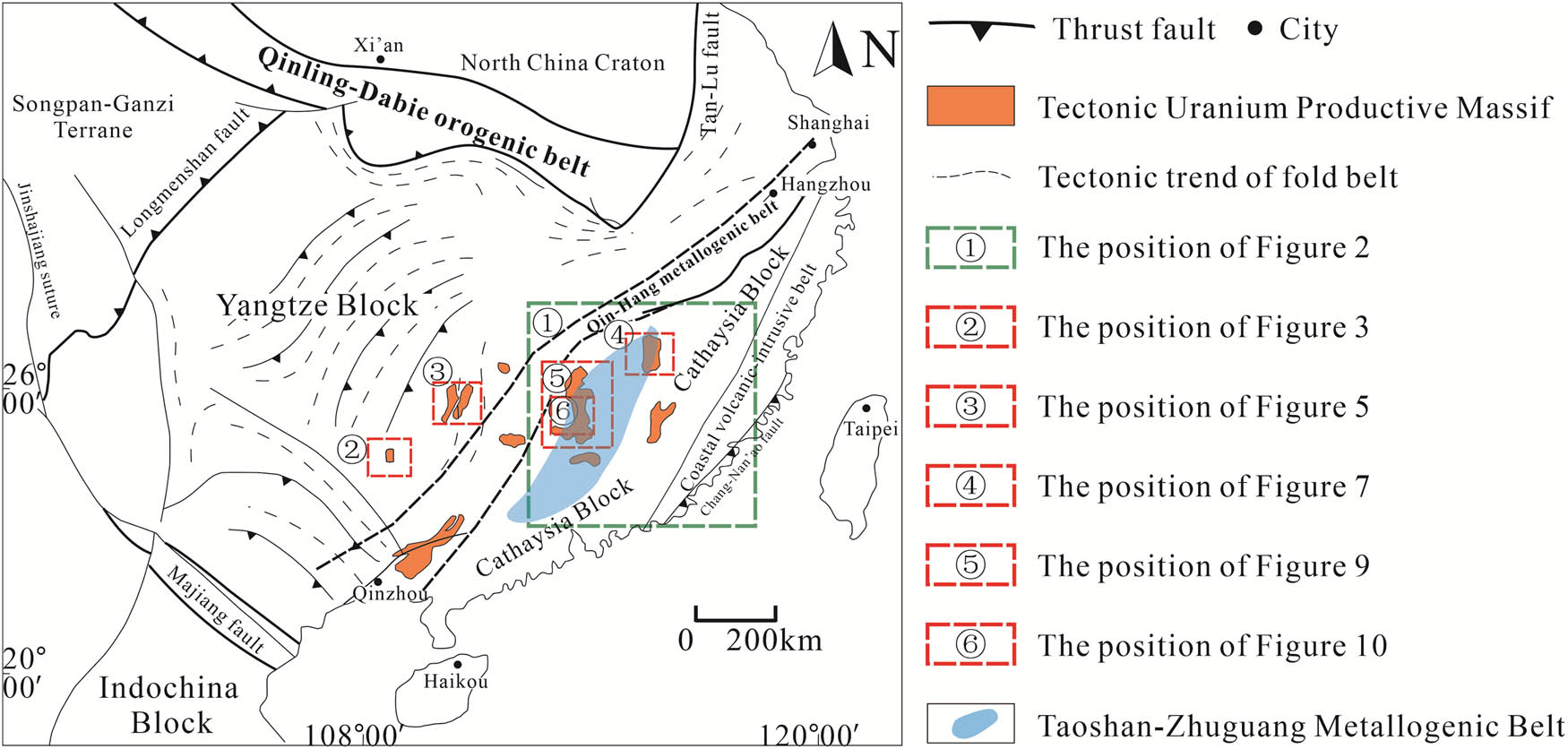
After the Early Mesozoic tectonic event, the transition from the Tethys tectonic domain to the Paleo-Pacific tectonic domain occurred in East Asia. The main reason for this activity is the low-angle subduction of the Paleo-Pacific toward the East Asian continental margin. In the process of low-angle subduction of the Pacific plate in the late Mesozoic, South China was located in the back-arc extension area of the Japanese island arc, resulting in strong thinning of the crust and lithosphere, and a large amount of granitic magma intrusion occurred. The strong subduction of the ancient Pacific plate not only formed a broad active continental margin but also triggered deep mantle activity, which promoted the upwelling and underplating of mantle-derived magma along the fault channel toward the continental margin extension area [31,38]. The uranium-bearing granites emplaced in the Yanshan period are widely distributed in Guangdong, Fujian, Hunan, Jiangxi, and other places. The eastern section of the Nanling Mountains on the south side of the Qin-Hang belt is the most important uranium metallogenic area in China (Figure 1) [31,39].
Tectonic framework of South China continent and uranium-bearing granite body.
According to the characteristics of uranium mineralization and ore-controlling structural units, previous scholars divided China into 5 metallogenic provinces and 18 metallogenic belts (Table 1) [40]. Located in South China are the South China Orogenic Belt Uranium Mineralization Province and the Southeastern Yangtze Block Mineralization Province [40]. Based on the distribution of uraniferous granites and related uranium fields and deposits in South China, Zhang et al. (2007) further divided the South China uranium metallogenic province into the Taoshan-Zhuguang and Chenzhou-Qinzhou uranium metallogenic belts (Figure 1), among which the Taoshan-Zhuguangshan uranium metallogenic belt is a vital uranium metallogenic belt in South China. The large uranium fields such as Taoshan, Zhuguangshan, Lujing, and Xiazhuang are located within this uranium metallogenic belt (Figure 2) [41,42].
Division table of uranium metallogenic belt (region) in South China [40]
| Name of the ore-forming unit | Deposit type | Main metallogenic | ||
|---|---|---|---|---|
| Metallogenic Province | Metallogenic Belt | Main type | Secondary type | Epoch |
| South China Orogenic Belt Uranium Mineralization Province | Gan-Hang | Volcanic type | Yanshanian period | |
| Wuyishan | Volcanic type | Granite-related | Yanshanian-Himalayan period | |
| Taoshan-Zhuguang | Granite-related | Carbonate siliceous-pelitic Rock Type | Yanshanian-Himalayan period | |
| Chenzhou-Qinzhou | Granite-related | Yanshanian period | ||
| Southeastern Yangtze Block Mineralization Province | Xuefengshan-Jiuwandashan | Carbonate siliceous-pelitic rock type | Granite-related | Yanshanian-Himalayan period |
| Mufushan-Hengshan | Carbonate siliceous-pelitic rock type | Granite-related | Yanshanian-Himalayan period | |
| Qixiashan-Luzong | Volcanic type | Yanshanian period | ||
| Uranium metallogenic area in western Yunnan | Sandstone type | Himalayan period | ||
![Figure 2
Geotectonic units, deep faults, and uranium distribution in the southern adjacent area [52].](/document/doi/10.1515/geo-2025-0871/asset/graphic/j_geo-2025-0871_fig_002.jpg)
Geotectonic units, deep faults, and uranium distribution in the southern adjacent area [52].
3 Ore-controlling structural characteristics
In hydrothermal uranium deposits, structure plays a fundamental role in controlling the migration and accumulation of ore-forming fluids [43,44]. Critically, deep-sourced fluids classified as (1) mantle-derived CO2-rich volatiles, (2) metamorphic devolatilization fluids, and (3) magmatic-hydrothermal exsolutions provide the essential medium for uranium transport as carbonate or fluoride complexes. Pre-existing faults, acting as preferential pathways for these deep fluids, represent rheologically weak zones prone to reactivation during subsequent tectonic events [45]. The deformation of faults and wall rocks generates permeable damage zones (e.g., fracture networks and breccias), which facilitate focused fluid flux and metal accumulation [46,47,48]. This explains the strong spatial correlation between damage zones and uranium mineralization [49,50,51], where fault architecture dictates fluid access to uranium sources (e.g., U-rich granites), while fluid-rock reactions in damage zones (e.g., CO2 degassing and sulfide reduction) trigger uranium precipitation.
The formation of granite-related uranium deposits in South China is closely related to the post-orogenic extensional (shear) structure in the Late Yanshanian. The hydrothermal uranium mineralization process in South China is temporally consistent with the Meso-Cenozoic extensional structures, including most of the uranium deposits in the Taoshan, Zhuguangshan, and Lujing areas [23].
The emplacement ages (145–45 Ma) of the basic dikes, which represent the extension of the continental lithosphere, are highly consistent with the formation age of a large number of hydrothermal uranium deposits formed in the fault structure of granite, acidic volcanic rock, and carbonate-silica-argillite in South China [52]. In addition, the three major stages of Late Yanshanian extensional tectonic activity (late Early Cretaceous to early Late Cretaceous, Late Cretaceous, and Paleogene) match the major stages of hydrothermal uranium mineralization in this region, and the evolution sequence of uranium mineralization types from east to west is completely consistent with the developmental sequence of extensional structures. In terms of spatial distribution, the Meso-Cenozoic extensional structure in South China has played a controlling role in the occurrence of hydrothermal uranium deposits. These structures provide favorable metallogenic space for hydrothermal uranium mineralization [52].
The granite-related uranium deposits are controlled by thermal uplift extensional structures, the volcanic-type uranium deposits by rifting extensional structures, and the carbon silica-mudstone-type uranium deposits by gravity extensional structures [52].
The Late Yanshanian extensional structure and its magmatism formed the hydrothermal and fracture systems, and the hydrothermal extraction of uranium from the uranium-rich granite in the Indosinian period formed the uranium-bearing hydrothermal solution, promoting the formation of the hydrothermal granite-related uranium deposits in South China [53].
Based on the location of uranium ore and granite, the ore body can be divided into three subcategories: the inner zone, the outer zone, and the overlying basin. However, the location of the ore body is mainly controlled by the fault structure itself (the fractured altered rock controlled by the fault) and the fault of the overlying basin [53].
The structural ore-controlling characteristics of the main uraniferous granites and their ore fields in South China are described in the following sections.
3.1 Motianling uranium ore field
The Motianling pluton is one of the earliest uraniferous granites in China formed during the Neoproterozoic and is also the oldest uraniferous granite pluton (850–760 Ma) in South China (Figure 3) [23,54]. The area has experienced multistage tectonic activities and the development of fault structures [55]. The main direction of the tectonic trends is northeast (NE)-striking, and the second is northwest (NW)-striking. The uranium-bearing granites in the area are mainly biotite granite, two-mica granite, and tourmaline-bearing granite [55,56]. The uranium mineralization in the Motianling district is primarily composed of pitchblende, associated with the emplacement of the host granites and subsequent dykes [32]. Recent studies have revealed that uranium in the Daliang uranium deposit can occur in the form of brannerite [56].
![Figure 3
Geological schematic map of the Motianling area in Northern Guangxi [32].](/document/doi/10.1515/geo-2025-0871/asset/graphic/j_geo-2025-0871_fig_003.jpg)
Geological schematic map of the Motianling area in Northern Guangxi [32].
The fault structure is well developed, and hydrothermal activity is ongoing. They interact and collectively influence the uranium mineralization process. A NE-trending deep fault represents the mineralizing fluid-conducting structure in the Motianling uranium mining area. Meanwhile, the ore-bearing structures mainly include NE- and NW-trending faults. The NE-trending shear zone controls uranium mineralization across the Motianling ore field. Within this system, the Daliang deposit (historically coded 376) hosts orebodies in NE-trending faults at granite contacts [32]; the Xincun deposit (coded 374), located 5 km northwest, is controlled by subsidiary SE-trending fractures branching from the same shear zone [56]. The Daliang deposit exhibits uranium mineralization that occurred almost simultaneously with the crystallization of the host granites. The pitchblende U–Pb results indicate that uranium mineralization occurred at 801–759 Ma. However, the region experienced uranium and lead fractionation at 374–295 Ma, interpreted as the remobilization and resetting of the original uranium [57]. This age coincides with the uplifting and hydrothermal alteration during the Caledonian post-orogenic extension [57]. The whole Motianling area, including the Daliang deposit, underwent a slow cooling path and was exposed at the surface during the Cenozoic [57,58].
The most important ore-controlling structure in the Motianling uranium ore field is the brittle-ductile shear zone with a width of 15 km. Studies show that the mobilization, migration, and precipitation of uranium are closely related to the brittle-ductile shear zones [17,59,60].
Chen et al. established a unified metallogenic model for the Daliang and Xincun deposits (historically coded as 376 and 374 in Chinese exploration archives) in Motianling [60]. The Motianling dome mainly experienced early contractional brittle-ductile shear, late tectonic inversion, brittle-ductile deformation, and tectonic evolution process of uplift: (1) Neoproterozoic (−820 Ma) nearly east-west fold and syntectonic magmatic rock emplacement; (2) in the Caledonian period, the top of the strata was thrusted to the NW (435–426 Ma); (3) post-Caledonian NE-trending upward ductile shear (426–295 Ma); (4) Late Yanshanian-Himalayan brittle-ductile extension (87–47 Ma); (5) the tectonic uplift and erosion since the Himalayan period (47 Ma to present).
The uranium metallogenic structural model of the Motianling granite-related uranium deposit is primarily characterized by a normal fault system with brittle-ductile shear. In the context of NW-SE regional extension and uplift, deep-sourced fluids, originating from the deep crust through magmatic and metamorphic processes, ascend and leach uranium from the parent granite. These fluids enriched in CO2, F−, and Cl− enhance uranium solubility and transport. Upon reaching the brittle-ductile transition zone or the redox interface, uranium precipitates, leading to the formation of ore bodies.
3.2 Miaoershan uranium ore field
The Miaoershan uranium ore field is located in the Yangtze block and is an important part of the Jiangnan orogenic belt. Miaoershan pluton is composed of Caledonian, Indosinian, and Yanshanian granites [9,61,62,63]. Although the main body of the rock is Caledonian granite, studies show that the granite related to uranium mineralization is mainly Indosinian granite. Uranium-bearing granites are mainly Douzhashan two-mica granite (204 ± 4 Ma) and Zhangjia two-mica granite (218 ± 1.4 Ma) [8,18]. The ore-forming age of the Menggongjie deposit in this area is 1.9 ± 0.7 Ma, which is the youngest known ore-forming age of granite-type uranium deposits. This period of uranium mineralization may be related to Quaternary volcanic activity (Figure 4) [64].
![Figure 4
Synthesized model showing uranium metallogenesis of the Motianling tectonic dome [17]. (a) Xuefeng period (820–760 Ma). (b) Caledonian period (453–426 Ma). (c) Post-Caledonian period (426–295 Ma). (d) Late Yanshan-Himalayan period (87–47 Ma). (e) Himalayan period (47 Ma) so far.](/document/doi/10.1515/geo-2025-0871/asset/graphic/j_geo-2025-0871_fig_004.jpg)
Synthesized model showing uranium metallogenesis of the Motianling tectonic dome [17]. (a) Xuefeng period (820–760 Ma). (b) Caledonian period (453–426 Ma). (c) Post-Caledonian period (426–295 Ma). (d) Late Yanshan-Himalayan period (87–47 Ma). (e) Himalayan period (47 Ma) so far.
The strike-slip fault is the main regional structure in this area. The Miaoershan uranium deposit is located on the hanging wall of the large-scale strike-slip fault zone. The Xinzi strike-slip fault plays an important role in the formation of the Miaoershan uranium deposit (Figure 5) [65,66]. Under the control of the Xinzi strike-slip fault, a series of NE- and north-northeast (NNE)-trending strike-slip fault structures developed in the Miaershan area, including Zhangjia, Shuanghuajiang-Niudajiang, Shazijiang, and Menggongjie fault zones, which are different in scale and ore-controlling characteristics [67]. Ore-bearing structures show multistage characteristics, affecting various mineralization stages. The Late Yanshan tectonic activities are the necessary conditions for mineralization, and the uranium source, structure, and preservation conditions are the key factors determining whether ore deposits can form (Figures 6 and 7).
Caledonian granite formation stage (440–381 Ma): In the late Wuyishan-Yunkai orogenic stage, the area is affected by the Caledonian movement of intracontinental folds and magma emplacement, forming the Miaoershan main batholith.
Formation of Indosinian granites and dikes (250–200 Ma): Several small batholiths, stocks, and acidic dikes were formed in the central Miaoershan under the influence of lithospheric thinning. The metamorphism and uranium enrichment of the intrusions laid the foundation of the uranium source for uranium mineralization.
Late Jurassic-Paleogene stage (150–50 Ma): Under the background of lithospheric extension, the magmatic activity in the Miaoershan area is weak, the mantle-derived basic magmatic activity is weak, and the tectonic activity is strong.
![Figure 5
Geological setting of the Miaoershan uranium district. Subfigure Clarification Label (a) belongs to Figure 1 (b) [65,66].](/document/doi/10.1515/geo-2025-0871/asset/graphic/j_geo-2025-0871_fig_005.jpg)
Geological setting of the Miaoershan uranium district. Subfigure Clarification Label (a) belongs to Figure 1 (b) [65,66].
![Figure 6
Uranium metallogenic model map of the Miaoershan granite-related uranium deposit [18].](/document/doi/10.1515/geo-2025-0871/asset/graphic/j_geo-2025-0871_fig_006.jpg)
Uranium metallogenic model map of the Miaoershan granite-related uranium deposit [18].
![Figure 7
Geological schematic map of the Taoshan uranium field [70].](/document/doi/10.1515/geo-2025-0871/asset/graphic/j_geo-2025-0871_fig_007.jpg)
Geological schematic map of the Taoshan uranium field [70].
The mantle fluid rich in mineralizing components (CO2) enters the crust along the deep fault, mixing with meteoric water entering the deep circulation to form the preliminary ore-forming fluid. Uranium in various geological bodies is extracted along the way during the rise of ore-forming fluids, and uranium is migrated in the form of
3.3 Taoshan uranium ore field
The Taoshan uranium ore field is located in the north of the Taoshan-Zhuguangshan metallogenic belt in South China uranium metallogenic province and the Taoshan strata in the middle of the Dawangshan-Yushan tectonic magmatic belt in the South China fold system [68,69]. The rock mass shows a NE-trending distribution pattern, and the Taoshan is a Caledonian and Yanshan multi-stage complex, which is a continental crust remelting-type granite; while uranium-bearing granite is mainly S-type [70]. The uranium deposits in the area mainly formed in the early Yanshan pluton and some in the Indosinian pluton [71]. The uranium-bearing granite body in this area is mainly Daguzhai biotite granite (218 ± 1.4 Ma) [8].
The tectonic activity in the area is strong, and there are many NE and NNE-trending faults and nearly EW-trending dike belts. The main ore-controlling structure is the Taoshan fault zone. The fault zone is the key factor in controlling the location of uranium deposits. The uranium deposits are mainly distributed in the middle section of the Taoshan Fault and the hanging wall of the NE section [71]. Fracture zones and cataclastic rock belts provide ore storage sites. For example, the strong activity of fault structures and dikes has formed a series of wide cataclastic altered rock belts in the upper wall of the Taoshan Fault and the branching area of the parallel Luokeng Fault, which provide a broad storage space for uranium mineralization [69,70]; the fault belt and uranium mineralization are closely related in space and time. For example, most of the uranium deposits in the Taoshan ore field are distributed in the fault belt, indicating that the fault belt and uranium mineralization are closely related in space. At the same time, from the perspective of time, the time of uranium mineralization is consistent with the main activity time of the fault belt [70].
The following description will take the Dabu uranium deposit as an example to analyze the metallogenic model of uranium formation in the Taoshan uranium deposit (Figure 8) [19]. The formation process of the Dabu uranium deposit can be divided into three stages:
Uranium-rich rock formation stage: During the Indosinian orogeny, mantle upwelling and asthenosphere upwelling led to the heating of the lower crust, inducing partial melting of both the lower crust and the ancient upper crust. The upper crustal clastic rocks, which are rich in uranium, provided the necessary conditions for the formation of uranium-rich magma. Yanshanian magmatic activity occurred in multiple pulses, with the magmatic front advancing from the southwest to the northeast. During the late stages of magmatic evolution, the uranium content gradually increased due to fractional crystallization and other processes.
Uranium pre-enrichment stage: During the middle Yanshan period, intense magmatic activity and crustal movement led to the formation of the Luobuli pluton surrounding the Daguzhai pluton, as well as to the initiation of the Taoshan and Luokeng faults. Post-magmatic hydrothermal fluids associated with the Luobuli pluton induced extensive alkali metasomatism, greisenization, and dolomitization of the Daguzhai pluton along the fault and fracture zones. Following alkali metasomatism, the crystalline uranium minerals in the rock were significantly altered, transforming into more mobile uranium species. These activated uranium species were then enriched in favorable locations such as rock fractures, mineral grain boundaries, and the surfaces of accessory minerals.
Uranium mineralization stage: In the Late Yanshan period, hydrothermal fluids associated with numerous basic dikes exhibited weakly alkaline conditions, which favored the enrichment of S²⁻ and the dissolution of CO2. These fluids subsequently extracted uranium from the source rocks. Upon entering the fracture system, the hydrothermal fluid experienced a rapid pressure drop, leading to the escape of CO2 and the decomposition of uranyl carbonate complexes. The ore-bearing hydrothermal fluid was then reduced by pyrite and other reducing agents, causing uranium mineralization to concentrate in the hematite mineralization zone.
![Figure 8
Metallogenic model of the Dabu uranium deposit: (a) Uranium-rich rock formation (Indosinian). (b) Pre-enrichment (Middle Yanshan). (c) Mineralization (Late Yanshan) [19].](/document/doi/10.1515/geo-2025-0871/asset/graphic/j_geo-2025-0871_fig_008.jpg)
Metallogenic model of the Dabu uranium deposit: (a) Uranium-rich rock formation (Indosinian). (b) Pre-enrichment (Middle Yanshan). (c) Mineralization (Late Yanshan) [19].
3.4 Zhuguangshan uranium ore field
The Zhuguangshan uranium ore field is located on the west side of the Cathaysia block and the south margin of the Cathaysia Caledonian fold belt of the South China fold system and is the intersection of several groups of regional structures (Figure 9) [72,73]. The Zhuguangshan pluton is a multistage intrusion of the giant batholith, which is an important component of the Wanyangshan-Zhuguangshan strike-slip magmatic belt [74,75]. Formed in the Caledonian period through the Late Paleozoic Period and reaching its peak in the late Indosinian and Yanshan intrusions, the Zhuguangshan pluton is a composite pluton composed of Silurian (435–420 Ma), Triassic (240–225 Ma), and Jurassic (165–150 Ma) granites, and the Cretaceous basic dykes are developed [52,76]. The uranium-bearing granites are mainly biotite granite and two-mica granite [10]. The ore-forming age of uranium deposits in this area is predominantly 95–54 Ma [10,12,77].
![Figure 9
Geological schematic map of Zhuguangshan rock mass [72,73].](/document/doi/10.1515/geo-2025-0871/asset/graphic/j_geo-2025-0871_fig_009.jpg)
The fault structure in the region is quite developed, which can be divided into SN-, NW-, and NE-trending groups and has the characteristics of multidirectional, large-scale, frequent activity, variable nature, and equal spacing distribution. These characteristics make a large number of uranium deposits developed in the strata.
Tectonic-magmatic activity is the most important ore-controlling factor, and the NE-trending faults are the most important ore-controlling fault in the region. For example, uranium deposits in the central area of Zhuguangshan mostly occur in the NE-trending fault zone [25]. The tectonic and magmatic activities in the area are continuous and frequent, and deep and large faults are developed, providing a heat source for the ore-forming hydrothermal fluid, affecting the structure and the strata, and then the accumulation and precipitation of uranium. The NW- or nearly EW-trending tectonic magmatic belt formed in the Late Yanshan period provided a heat source and played a decisive role in uranium mineralization. The intersection of different tectono-magmatic belts is closely related to the location of uranium deposits. Several faults in the area control the development of fault belts and composite fault belts and control the distribution and location of ore deposits.
3.5 Lujing uranium ore field
The Lujing uranium ore field is located at the junction of Hunan, Guangdong, and Jiangxi Provinces and the west margin of the Fujian-Jiangxi post-Caledonian fold belt in the Nanhua active belt between the Yangtze Plate and the Cathaysian Plate (Figure 10) [25,78]. The strata of the mining area are the middle part of a broad intrusion complex, mainly Indosinian granite, the second is the Yanshanian granite, and the main uranium mineralization occurs in the Indosinian biotite granite (235.4 ± 1.1 Ma) [79]. The ore-forming age of uranium deposits in this area is mainly concentrated in 103–48 Ma [8,24].
![Figure 10
Geological structure map of the Lujing uranium ore field in the central Zhuguangshan Mountains [78].](/document/doi/10.1515/geo-2025-0871/asset/graphic/j_geo-2025-0871_fig_010.jpg)
Geological structure map of the Lujing uranium ore field in the central Zhuguangshan Mountains [78].
The Lujing uranium ore field is controlled by the Suichuan-Reshui strike-slip fault zone. The separation between the Suichuan fracture and the Reshui fracture is reduced laterally, giving rise to a pull-apart basin, which further controls the scope of the Lujing uranium ore field [24,80]. The tectonic structure in the area is mainly NE-trending faults and NW-trending folds. The NE-trending fault zone is the main ore-controlling fault zone of the Lujing uranium deposit [81]. Deposits are mainly distributed in the NE-trending fault zone and its secondary faults. The uranium ore body inside the granite body is significantly controlled by the fault, and its occurrence is consistent with the ore-bearing fault, showing NE and NNE directions [24,25].
The following will take the Yangjiaonao uranium deposit as an example to analyze the metallogenic model of uranium in the Lujing uranium ore field (Figure 11). The formation process of Yangjiaonao uranium deposit can be divided into three stages [20].
![Figure 11
Metallogenic model diagram of the Yangjiaonao uranium deposit. (a) First stage. (b) Second stage. (c) Third stage [20].](/document/doi/10.1515/geo-2025-0871/asset/graphic/j_geo-2025-0871_fig_011.jpg)
Metallogenic model diagram of the Yangjiaonao uranium deposit. (a) First stage. (b) Second stage. (c) Third stage [20].
First stage: Emplacement stage of granite magma. The intrusion of granite magma during the middle Indosinian period formed the main body of granite in this area. The emplacement age of the granite magma intrusion is constrained between 228 and 206 Ma.
Second stage: Uranium pre-enrichment stage. During the late stage of the early Yanshan period, granite magma intruded again, forming small batholiths and stocks within the pre-existing pluton. During the crystallization and differentiation of the small pluton, high-temperature hydrothermal fluids were generated. These hydrothermal fluids, rich in CO2 and other mineralizing agents, induced high-temperature hydrothermal alteration near the contact zone between the small pluton and the surrounding rock, leading to the pre-enrichment of uranium.
Third stage: Uranium mineralization (128–51 Ma). Low-mineralized hydrothermal solutions, sourced from deep crustal fluids (potentially mantle-derived CO2-rich fluids and/or metamorphic dehydration fluids), ascended through regional-scale fault systems. During migration, these fluids leached U⁴⁺ from the pre-enriched Indosinian granites and mixed with infiltrated meteoric water. Upon entering upper tectonic zones, uranium precipitated primarily as pitchblende within structural open spaces (e.g., fracture zones and fault intersections), facilitated by fluid boiling and redox reactions during crustal denudation.
3.6 Multiscale structural control on uranium mineralization in South China
The spatial-temporal distribution of granite-related uranium deposits in South China is hierarchically controlled by structures across three scales:
Regional scale (10–100 km). NE-trending deep faults (e.g., Chenzhou-Qinzhou Fault) act as crustal-scale conduits, channeling mantle-derived CO2 and metamorphic fluids to thermally and chemically prime uranium-rich granites [16]. These structures define metallogenic belts (e.g., Taoshan-Zhuguangshan belt), with uranium ore fields preferentially clustered near fault intersections (e.g., Zhuguangshan’s SN + NW + NE structural nexus) [16,82,83]. Regional strike-slip faults (e.g., Miaoershan-Xinzi Fault) function as stress partitioners and crustal-scale fluid conduits, controlling ore-field boundaries [84,85]. Thrust-nappe structures (Caledonian-Indosinian) created pre-enriched uranium sources through basement deformation, as evidenced by Motianling’s Neoproterozoic-Caledonian thrust sheets (435–426 Ma) hosting remobilized uranium [56,60].
District scale (1–10 km). Strike-slip faults generate dilation sites for mineralization: pull-apart basins along releasing bends (e.g., Lujing’s Suichuan-Reshui fault system) trap ascending fluids [79,82,86]. The secondary faults derived from regional faults (e.g., NNE-trending secondary fault Tianjin Fault derived from the Xinzi Fault) directly control the distribution of uranium deposits. The fault zone provides migration channels and precipitation space for uranium-bearing fluids [84]. Brittle-ductile shear zones (e.g., Motianling’s 15 km-wide shear corridor) compartmentalize fluid flow: ductile domains facilitate fluid–rock interaction and uranium leaching, while brittle domains host uranium precipitation at strain gradients (e.g., Daliang deposit at granite-shear zone contacts) [56,60,87].
Orebody scale (<1 km). Cataclastic breccias in fault cores (e.g., NE-trending structures in the Zhuguang Massif) exert primary control over uranium distribution. The breccia zone in the Lujing area, generated by cataclasis of massive quartz during mid-late Early Cretaceous tectonism, served as a conduit for ore-forming fluids. Hydrothermal fluids migrating along the QFII fault and associated fractures (including the breccia zone) precipitated uranium minerals via fluid–rock interaction [82,88]. The alteration of fluids along microcracks controls the activation of uranium (e.g., red beds around the Miaoershan area) [89]. Hydrothermal fluids infiltrating through microcracks in granite or clastic rocks leached uranium from uranium-bearing minerals (zircon and uraninite) to form uranium-rich hydrothermal fluids [84,86,90].
4 Metallogenic stage and tectonic period
Large-scale mineralization is closely related to crustal tectonic activities. From the perspective of the whole of South China, there is a significant difference between the age of granite and the age of uranium deposits. The age distribution of uraniferous granites is varied, for example, the uraniferous granites in the Motianling area belong to the Xuefengian Period, while the uraniferous granites in the Zhuguang area belong to the Indosinian and Yanshanian ages. However, the age of uranium mineralization is mainly concentrated in the Late Yanshanian to the Alpine stage [52]. The Mesozoic experienced two large-scale tectonic movements, resulting in large-scale magmatic tectonic activity and metallogenic explosion; from the late Indosinian to the early Yanshanian, the Asian continent collided with the Indian Plate, and East China was affected by the north-south compressive stress. The middle Yanshan period (150 Ma) and later periods were mainly affected by the compressive stress field of the Pacific Plate subduction to the west [91].
The formation of granite-related uranium deposits involves several independent geological processes. Diagenesis and mineralization are two relatively independent processes. Granite plays a dual role in this process: it is both a source of uranium and provides a beneficial ore-hosted space. While it is suggested that granite may not be directly genetically related to other aspects of the uranium mineralization process, recent studies have indicated that magmatic or fluid activities at late stages may contribute to mineralization [78], highlighting the need for a comprehensive approach to understanding the interplay of various geological factors in the formation of these deposits. These later geological processes played a key role in uranium enrichment and mineralization. They create the necessary conditions for the migration and precipitation of uranium, thus contributing to the formation of uranium deposits [92,93]. The metallogenic stages of the granite-related uranium deposit in South China are closely associated with tectonic periods because they coincide with major tectonic movements.
4.1 Caledonian-Late Paleozoic tectonic movement
During the Caledonian period, a large-scale crustal stretching event occurred in South China, resulting in strong folding and fracture deformation and triggering extensive and intense magmatic activity [35,94].
Under the background of an extensional tectonic environment, a regional metamorphic event occurred in the Motianling area. Significant metamorphism occurred in the original intrusions and the surrounding strata, reactivating uranium in both lithologies. In the late Caledonian to Late Paleozoic period, numerous low-pressure tectonic areas formed in the Motianling area. A large amount of uranium-rich hydrothermal fluid migrated through the regional ore-guiding structure to the secondary faults [32].
The Miaoershan area had a strong intracontinental compression and crustal thickening during the Caledonian-Late Paleozoic tectonic movement. The pre-Devonian lithologies were compressed in the SE-NW direction to form the Miaoershan-Yuechengling complex anticline, whose core strata underwent various forms of transformation, forming the continental crust-derived uranium-rich granite that intruded the anticline axis.
4.2 Indosinian tectonic movement
The Mesozoic orogeny in South China started from the Indosinian orogeny [95], with many uranium deposits generated during the active tectonism. For example, the Taoshan pluton was strongly compressed by the Yangtze Plate and the Cathaysia Plate during this tectonic period. The deep burial of the inland crust in this area caused anatexis, forming remelting-type granite. In the Miaoershan uranium ore field, the Indosinian tectonic movement caused the bending of the Late Paleozoic strata, resulting in the formation of fracture zones between the uranium-bearing layers and related structures. Although no large-scale metal mineralization events occurred during this period, the Indosinian granite is closely related to uranium mineralization. The granite in this period generally has a high uranium content and is often the source rock of granite-related uranium deposits [95].
4.3 Yanshan-Alpine tectonic movement
During the Late Yanshanian to early Himalayan period, the South China continent was subjected to lithosphere extensional thinning, providing a favorable tectonic environment for the precipitation of uranium ore-forming materials [25,32,77,92]. Under the tectonic setting of this area, a regional uranium mineralization event occurred, leading to the development of several deposits within granite bodies such as Motianling, Zhuguang, Guidong, and Taoshan plutons [96,97].
Extensional and strike-slip structures characterize the Motianling uranium area. In this tectonic regime, a series of NNE-trending faults developed in the Motianling mining area, which communicated deep ore-forming materials and fluids, and formed a wide range of uranium mineralization events, such as the Xincun uranium deposit formed in the early Yanshan. During this period, the Xinzi strike-slip fault zone was frequently active, and the main ore-controlling faults in the NE and NNE directions formed in the Miaoershan intrusion, and secondary faults in the NW direction were derived, affecting the early ore body and promoting the activation, transfer, and enrichment of uranium [67]. In the Late Yanshan period, under the influence of regional left-lateral slip stress, the fracture structure of the Miaoershan ore field changed from transpression to transtension, and a new large fault zone opened, which communicated deep and shallow zones and caused a large amount of ore-forming hydrothermal fluid to move to shallow areas and promoted uranium mineralization in the Miaoershan area.
In the Late Yanshan period, influenced by the lower subduction velocity of the Pacific Plate and the migration of the subduction zone to the Pacific Ocean, the South China continental margin area changed from strong compression to strong tension, and strong fault block movement occurred, resulting in the formation of NE and NNE extensional structures, rift belts, and red sedimentary basins in this area, having a significant impact on the uranium mineralization event in the Taoshan uranium ore field [69].
The Zhuguangshan uranium ore field has experienced crustal movements that formed a series of fault structures. The Yanshan stage is a rock-controlled fault structure, whereas the Himalayan stage is a basin-controlled fault structure. The fault structure has the characteristics of multistage activity and controls magmatic activity and basin development since the middle Cenozoic era, resulting in uranium mineralization in the Zhuguangshan uranium ore field [7].
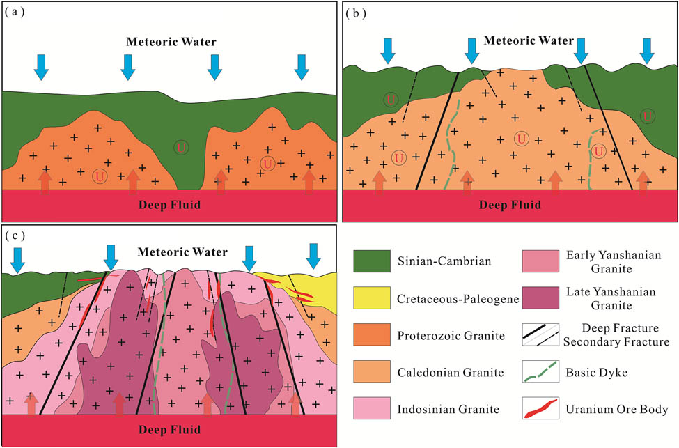
Granite-related uranium deposits in South China are the products of polygenetic mineralization involving deep mantle fluid and meteoric water (Figure 12). (1) Proterozoic-Early Paleozoic: the oxygen content in the atmosphere increased, the oxidation of uranium by weathering was enhanced, and the uranium content entering the water body was significantly increased. Under the comprehensive influence of meteoric water and magmatic hydrothermalism, uranium was enriched in the intrusion and strata (Figure 12a). (2) Late Paleozoic-Mesozoic: the South China Plate was affected by the Caledonian movement, and strong folds and large-scale granite magmatic activities occurred. The intracontinental cracking event in the late Paleozoic developed many fault structures. Atmospheric precipitation circulated along the fault, extracted uranium from the basement and granite, and formed a local enrichment zone of uranium (Figure 12b). (3) Late Mesozoic-Cenozoic: the lithospheric extension event in the late Yanshan-early Himalayan period induced the emplacement of mantle-derived basic dykes, providing deep heat sources and ascending channels. The mantle-derived fluid (containing CO2, F, and CH4) rises along the deep fault and mixes with the uranium-rich atmospheric precipitation to form a uranium-bearing hydrothermal solution, which finally realizes the precipitation of uranium and the formation of the deposit (Figure 12c). The granite-related uranium deposits are controlled.

Metallogenic model diagram of granite-related uranium deposits in South China. (a) Proterozoic-Early Paleozoic. (b) Late Paleozoic-Mesozoic. (c) Late Mesozoic-Cenozoic.
5 Conclusions
Granite-related uranium deposits in China are mainly distributed in the South China Plate. The spatial location of the deposit is jointly controlled by multi-level structures: on the regional scale, NE-trending deep faults (e.g., Chenzhou-Qinzhou Fault) serve as ore-conducting structures to transport mantle-derived fluids; on the ore field scale, strike-slip faults (e.g., Xinzi Fault) and their pull-apart basins (e.g., Lujing ore field) provide the ore-hosting space; on the ore body scale, brittle-ductile shear zones (Motianling) and cataclastic breccia zones (Zhuguangshan) directly control uranium precipitation.
The uranium-bearing granites in South China were mainly formed in the Indosinian-Yanshanian period (250–150 Ma), but large-scale mineralization was concentrated in the late Yanshanian-Himalayan period (95–45 Ma), showing significant time difference. This lag is attributed to post-orogenic extension events and mantle-derived fluid injection that enhanced uranium mobility and precipitation.
The post-orogenic extensional structure in the late Yanshan period is closely related to the granite-related uranium deposits in South China. Regional granite-related uranium mineralization occurred in the extensional tectonic setting of the South China continent, and several large-scale uranium deposits were developed in the Taoshan, Zhuguang, and Guidong plutons.
Concerning the metallogenic model of granite-related uranium deposits in four groups of different uranium deposits described in this article, it has been shown that the whole process of the formation of granite-related uranium deposits includes: preliminary pre-enrichment of uranium → formation and migration stages of ore-forming fluid → phase of uranium metallization. During the uranium mineralization stage, the fault structure provides a channel for the migration of hydrothermal fluid, extracting uranium from the geological body along the way. A series of physical and chemical reactions occur in the structurally open spaces in the shallow crust to precipitate the ores.
-
Funding information: This study was supported by the ‘Open Bidding for Selecting the Best Candidates’ project of China National Uranium Co., Ltd. (project No. 202304).
-
Author contributions: Conceptualization: A.G. and H.L.; writing – original draft: A.G. and H.L.; writing – review & editing: A.G., H.L., and M.G.; funding acquisition: H.L., H.C., and S.G.; project administration: P.O. and Q.W.; resources: D.Z. and Y.M. All authors have read and agreed to the published version of the manuscript.
-
Conflict of interest: The authors declare there are no conflicts of interest.
-
Data availability statement: This manuscript is a comprehensive review article. No new datasets were generated or analyzed during this study. All data discussed are derived from publicly available sources cited in the reference list.
References
[1] Zhang JD. Summarized analysis on potential of uranium resources in China and strategy for uranium geologic exploration. Uranium Geol. 2004;20(5):260–5.Search in Google Scholar
[2] Zhang JD, Li ZY, Cai YQ, Guo QY, Li YL, Han CQ. The main advance and achievements in the potential evaluation of uranium resource in China. Uranium Geol. 2012;28(6):321–6.Search in Google Scholar
[3] Cai YQ, Zhang JD, Li ZY, Guo QY, Song JY, Fan HH, et al. Outline of uranium resources characteristics and metallogenetic regularity in China. Acta Geol Sin-Engl Ed. 2015;89(3):918–37.10.1111/1755-6724.12490Search in Google Scholar
[4] Li Q, Chen Q, Wang JB, Chen YJ, Kang LG, Chen B, et al. Current situation of uranium resources in the world and suggestions on resource guarantee of nuclear power development in China. China Min Mag. 2023;32(3):1–9.Search in Google Scholar
[5] Li Q, Wang J, Xu Q. General situation and prospect on supply and demand trend of the world uranium re-sources. China Min. 2013;22:13–8.Search in Google Scholar
[6] Zhang L, Chen ZY, Wang FY. General characteristics and research progresses in metallogenesis of granite-related uranium deposits in South China. Acta Petrol Sin. 2021;37(9):2657–76.10.18654/1000-0569/2021.09.04Search in Google Scholar
[7] Deng P, Shu L, Tan Z. The geological setting for the formation of rich uranium ores in Zhuguang-Guidong large-scale uranium metallogenetic area. Geol Rev. 2003;49(5):486–94.Search in Google Scholar
[8] Zhang C, Cai YQ, Dong Q, Xu H. Cretaceous-Neogene basin control on the formation of uranium deposits in South China: Evidence from geology, mineralization ages, and H-O isotopes. Int Geol Rev. 2020;62(3):263–310.10.1080/00206814.2019.1598898Search in Google Scholar
[9] Zhao KD, Jiang SY, Ling HF, Sun T, Chen WF, Chen PR, et al. Late Triassic U-bearing and barren granites in the Miao’ershan batholith, South China: Petrogenetic discrimination and exploration significance. Ore Geol Rev. 2016;77:260–78.10.1016/j.oregeorev.2016.02.016Search in Google Scholar
[10] Zhang L, Chen ZY, Li XF, Li SR, Santosh M, Huang GL. Zircon U-Pb geochronology and geochemistry of granites in the Zhuguangshan complex, South China: Implications for uranium mineralization. Lithos. 2018;308–309:19–33.10.1016/j.lithos.2018.02.029Search in Google Scholar
[11] Chen YW, Bi XW, Hu RZ, Dong SH. Element geochemistry, mineralogy, geochronology and zircon Hf isotope of the Luxi and Xiazhuang granites in Guangdong Province, China: Implications for U mineralization. Lithos. 2012;150:119–34.10.1016/j.lithos.2012.06.025Search in Google Scholar
[12] Zhong FJ, Yan J, Xia F, Pan JY, Liu WQ, Lai J, et al. In-situ U-Pb isotope geochronology of uraninite for Changjiang granite-type uranium ore field in northern Guangdong, China: Implications for uranium mineralization. Acta Petrol Sin. 2019;35(9):2727–44.10.18654/1000-0569/2019.09.07Search in Google Scholar
[13] Zhang C, Cai YQ, Dong Q, Xu H, He S. Genesis of the South Zhuguang uranium ore field, South China: Fluid inclusion and H-C-O-S-Sr isotopic constraints. Appl Geochem. 2019;100:104–20.10.1016/j.apgeochem.2018.11.008Search in Google Scholar
[14] Zhang L, Chen ZY, Wang FY, White NC, Zhou TF. Release of uranium from uraninite in granites through alteration: Implications for the source of granite-related uranium ores. Econ Geol. 2021;116(5):1115–39.10.5382/econgeo.4822Search in Google Scholar
[15] Mao JW, Xie GQ, Li XF, Zhang CQ, Mei YX. Mesozoic large scale mineralization and multiple lithispheric extension in South China. Earth Sci Front. 2004;11(1):45–55.Search in Google Scholar
[16] Fan HH, Pang YQ, He DB, Chen DH, Wang YJ, Sun YQ, et al. Metallogenic process and prediction of granite-related uranium deposits in South China. Acta Geosci Sin. 2023;44(5):887–96.Search in Google Scholar
[17] Qiu L, Yan DP, Ren MH, Cao WT, Tang SL, Guo QY, et al. The source of uranium within hydrothermal uranium deposits of the Motianling mining district, Guangxi, South China. Ore Geol Rev. 2018;96:201–17.10.1016/j.oregeorev.2018.04.001Search in Google Scholar
[18] Wang ZQ. Study on metallogenic mechanism of Miaoershan granite-related uranium deposit in Guangxi. Beijing: Beijing Research Institute of Uranium Geology; 2018.Search in Google Scholar
[19] Wang HR, Shao WJ, Zhou D, Zhao SJ. Study on metallogenic model of Dabu uranium deposit in Taoshan uranium ore field of Jiangxi. World Nucl Geosci. 2020;37(4):263–70.Search in Google Scholar
[20] Pan CR. Geological characteristics and genesis of Yangjiaonao uranium deposit in Hunan. Kunming: Kunming University of Science and Technology; 2017.Search in Google Scholar
[21] Ling H. Origin of hydrothermal fluids of granite-related uranium deposits: Constraints from redox conditions. Geol Rev. 2011;57(2):193–206.Search in Google Scholar
[22] Bierlein FP, Gray DR, Foster DA. Metallogenic relationships to tectonic evolution - the Lachlan Orogen, Australia. Earth Planet Sci Lett. 2002;202(1):1–13.10.1016/S0012-821X(02)00757-4Search in Google Scholar
[23] Hu RZ, Bi XW, Zhou MF, Peng JT, Su WC, Liu S, et al. Uranium metallogenesis in South China and its relationship to crustal extension during the Cretaceous to Tertiary. Econ Geol. 2008;103(3):583–98.10.2113/gsecongeo.103.3.583Search in Google Scholar
[24] Zhang WL, He XM, Lv C, Wei WJ. Analysis on the metallogenic feature and ore-controlling factors in Lujing uranium ore field. Uranium Geol. 2011;27(2):81–7.Search in Google Scholar
[25] Sun Y, Pan JY, Xiao ZH, Liu Y, Pan CR, Zhong FJ, et al. Structural analysis and ore-prospecting prediction of the Lujing uranium ore field in middle Zhuguangshan, South China. Geol China. 202047(2):362–74.Search in Google Scholar
[26] Li ZX, Li X, Kinny P, Wang J. The breakup of Rodinia: did it start with a mantle plume beneath South China. Earth Planet Sci Lett. 1999;173(3):171–81.10.1016/S0012-821X(99)00240-XSearch in Google Scholar
[27] Wang J, Pan G. Neoproterozoic South China palaeocontinents: an overview. Acta Sedimentol Sin. 2009;27(5):818–25.Search in Google Scholar
[28] Zhang YQ, Dong SW, Li JH, Cui JJ, Shi W, Su JB, et al. The new progress in the study of Mesozoic tectonics of South China. Diqiu Xuebao (Acta Geosci Sin). 2012;33(3):257–79.Search in Google Scholar
[29] Wang YJ, Fan WM, Zhang GW, Zhang YH. Phanerozoic tectonics of the South China Block: Key observations and controversies. Gondwana Res. 2013;23(4):1273–305.10.1016/j.gr.2012.02.019Search in Google Scholar
[30] Zhang GW, Guo AL, Wang YJ, Li SZ, Dong YP, Liu SF, et al. Tectonics of South China continent and its implications. Sci China-Earth Sci. 2013;56(11):1804–28.10.1007/s11430-013-4679-1Search in Google Scholar
[31] Shu SL. An analysis of principal features of tectonic evolution in South China Block. Geol Bull China. 2012;31(7):1035–53.Search in Google Scholar
[32] Xu ZQ, Song H, Yin MH, Zhang CJ, Cheng FG, Tang CY. Uranium metallogenic mechanism of Neoproterozoic granites in South China: A case study from the Motianling granite. Acta Petrol Sin. 2019;35(9):2695–710.10.18654/1000-0569/2019.09.05Search in Google Scholar
[33] Sun T. A new map showing the distribution of granites in South China and its explanatory notes. Geol Bull China. 2006;25(3):332–5.Search in Google Scholar
[34] Qiu L, Yan DP, Tang SL, Wang Q, Yang WX, Tang X, et al. Mesozoic geology of Southwestern China: Indosinian foreland overthrusting and subsequent deformation. J Asian Earth Sci. 2016;122:91–105.10.1016/j.jseaes.2016.03.006Search in Google Scholar
[35] Shu LS, Yu JH, Jia D, Wang B, Shen WZ, Zhang YQ. Early Paleozoic orogenic belt in the eastern segment of South China. Geol Bull China. 2008;27(10):1581–93.Search in Google Scholar
[36] Deng P, Ren JS, Ling HF, Shen WZ, Sun LQ, Zhu B, et al. SHRIMP zircon U-Pb ages and tectonic implications for Indosinian granitoids of southern Zhuguangshan granitic composite, South China. Chin Sci Bull. 2012;57:1542–52.10.1007/s11434-011-4951-8Search in Google Scholar
[37] Cai Y, Lu J, Ma D, Huang H, Zhang H, Zhang R. The Late Triassic Dengfuxian A-type granite, Hunan Province: age, petrogenesis, and implications for understanding the late Indosinian tectonic transition in South China. Int Geol Rev. 2015;57(4):428–45.10.1080/00206814.2015.1012565Search in Google Scholar
[38] Qiu L, Li X, Li XW, Yan DP, Ren MH, Zhang LL, et al. Petrogenesis of early Cretaceous intermediate to felsic rocks in Shanghai, South China: Magmatic response to Paleo-Pacific plate subduction. Tectonophysics. 2022;838:229469.10.1016/j.tecto.2022.229469Search in Google Scholar
[39] Yang MG, Huang SB, Lou FS, Tang WX, Mao SB. Lithospheric structure and large-scale metallogenic process in Southeast China continental area. Geol China. 2009;36(3):528–43.Search in Google Scholar
[40] Huang JB, Huang SJ. Regional metallogenic characteristics of China’s uranium resources. Uranium Geol. 2005;21(3):129–38.Search in Google Scholar
[41] Zhang JD, Li YL, Jian XF. Situation and development prospect of uranium resources exploration in China. Eng Sci. 2007;9(4):118–27.10.1016/j.mseb.2006.09.023Search in Google Scholar
[42] Fan H, He D, Xu H. The potential evaluation of granite type uranium resources in China. Uranium Geol. 2012;28(6):335–41.Search in Google Scholar
[43] Hayward KS, Cox SF. Melt welding and its role in fault reactivation and localization of fracture damage in seismically active faults. J Geophys Res-Solid Earth. 2017;122(12):9689–713.10.1002/2017JB014903Search in Google Scholar
[44] Chi GX, Xu DR, Xue CJ, Li ZH, Ledru P, Deng T, et al. Hydrodynamic links between shallow and deep mineralization systems and implications for deep mineral exploration. Acta Geol Sin-Engl Ed. 2022;96(1):1–25.10.1111/1755-6724.14903Search in Google Scholar
[45] Sibson RH. Seismogenic framework for hydrothermal transport and ore deposition. Society of Economic Geologists, Vol. 14, 2001. p. 25–55.10.5382/Rev.14.02Search in Google Scholar
[46] Gessner K. Coupled models of brittle-plastic deformation and fluid flow: approaches, methods, and application to Mesoproterozoic mineralisation at Mount Isa, Australia. Surv Geophys. 2009;30:211–32.10.1007/s10712-009-9062-6Search in Google Scholar
[47] Li Z, Chi G, Bethune KM, Eldursi K, Quirt D, Ledru P, et al. Numerical simulation of strain localization and its relationship to formation of the Sue unconformity-related uranium deposits, eastern Athabasca Basin, Canada. Ore Geol Rev. 2018;101:17–31.10.1016/j.oregeorev.2018.07.004Search in Google Scholar
[48] Igonin N, Verdon JP, Kendall JM, Eaton DW. Large‐scale fracture systems are permeable pathways for fault activation during hydraulic fracturing. J Geophys Res: Solid Earth. 2021;126(3):e2020JB020311.10.1029/2020JB020311Search in Google Scholar
[49] Oliver N, Pearson P, Holcombe R, Ord A. Mary Kathleen metamorphic‐hydrothermal uranium-rare‐earth element deposit: Ore genesis and numerical model of coupled deformation and fluid flow. Aust J Earth Sci. 1999;46(3):467–84.10.1046/j.1440-0952.1999.00718.xSearch in Google Scholar
[50] Li ZH, Chi GX, Bethune KM, Thomas D, Zaluski G. Structural controls on fluid flow during compressional reactivation of basement faults: insights from numerical modeling for the formation of unconformity-related uranium deposits in the Athabasca Basin, Canada. Econ Geol. 2017;112(2):451–66.10.2113/econgeo.112.2.451Search in Google Scholar
[51] Li ZH, Chi GX, Bethune KM, Eldursi K, Quirt D, Ledru P, et al. Interplay between thermal convection and compressional fault reactivation in the formation of unconformity-related uranium deposits. Miner Depos. 2021;56(7):1389–404.10.1007/s00126-020-01011-6Search in Google Scholar
[52] Chen ZY, Huang GL, Zhu B, Chen ZH, Huang F, Zhao Z, et al. The characteristics and metallogenic specialization of granite-hosted uranium deposits in the Nanling region. Geotecton Metallog. 2014;38(2):264–75.Search in Google Scholar
[53] Zhao R, Wang D, Chen Y, Leng C, Qin J, Zhao C. Geological characteristics, metallogeny and geospatial mineralization model of uranium in the Nanling metallogenic belt. Acta Geol Sin. 2020;94(1):149–60.Search in Google Scholar
[54] Zhang Z, Shen W, Rao B. A study on the isotopic geology of No. 376 uranium deposit. J Nanjing Univ. 1984;3:543–53.Search in Google Scholar
[55] Song H, Xu Z, Ni S, Zhang C, Liang J, Cheng F, et al. Response of the Motianling granitic pluton in North Guangxi to the tectonic evolution in the southwestern section of the Jiangnan Orogenic Belt: Constraints from Neo-proterozoic zircon geochronology. Geotecton Metallog. 2015;39(6):1156–75.Search in Google Scholar
[56] Wang YJ, Pang YQ, Fan HH, Wu Y, Zhang J, Yang H, et al. Mineralogical studies ofore and gangue minerals in Daliang and Xincun deposits of Motiangling ore district, norther Guangxi, South China: Implications for ore genesis. Acta Geol Sin. 2025;99(4):1256–73.Search in Google Scholar
[57] Qiu L, Yan DP, Tang SL, Arndt NT, Fan LT, Guo QY, et al. Cooling and exhumation of the oldest Sanqiliu uranium ore system in Motianling district, South China Block. Terra Nova. 2015;27:449–57.10.1111/ter.12179Search in Google Scholar
[58] Qiu L, Yan DP, Tang SL, Chen F, Gong LX, Zhang YX. Cenozoic exhumation of the Neoproterozoic Sanfang batholith in South China. J Geol Soc. 2019;177(2):412–23.10.1144/jgs2019-041Search in Google Scholar
[59] Yan DP, Zhou MF, Song HL, Fu ZR, Sun M. Tectonic controls on the formation of the Liwu Cu-rich sulfide deposit in the Jianglang dome, SW China. Resour Geol. 2003;53(2):89–100.10.1111/j.1751-3928.2003.tb00161.xSearch in Google Scholar
[60] Chen F, Yan DP, Qiu L, Yang WX, Tang SL, Guo QY, et al. The brittle-ductile shearing and uranium metallogenesis of the Motinaling dome in the southwestern Jiangnan Orogenic Belt. Acta Petrol Sin. 2019;35(9):2637–59.10.18654/1000-0569/2019.09.02Search in Google Scholar
[61] Zhao KD, Jiang SY, Sun T, Chen WF, Ling HF, Chen PR. Zircon U-Pb dating, trace element and Sr-Nd-Hf isotope geochemistry of Paleozoic granites in the Miao’ershan-Yuechengling batholith, South China: Implication for petrogenesis and tectonic-magmatic evolution. J Asian Earth Sci. 2013;74:244–64.10.1016/j.jseaes.2012.12.026Search in Google Scholar
[62] Hu H, Wang R, Chen W, Ding H, Ling H, Chen P, et al. Characteristics of biotite in uranium-and non-uranium-bearing granites from northeastern Guangxi province, China: implications on uranium mineralization. Acta Miner Sin. 2014;34(3):321–7.Search in Google Scholar
[63] Zhao KD, Jiang SY, Ling HF, Palmer MR. Reliability of LA-ICP-MS U-Pb dating of zircons with high U concentrations: A case study from the U-bearing Douzhashan Granite in South China. Chem Geol. 2014;389:110–21.10.1016/j.chemgeo.2014.09.018Search in Google Scholar
[64] Luo JC, Hu RZ, Fayek M, Bi XW, Shi SH, Chen YW. Newly discovered uranium mineralization at ∼ 2.0 Ma in the Menggongjie granite-hosted uranium deposit, South China. J Asian Earth Sci. 2017;137:241–9.10.1016/j.jseaes.2017.01.021Search in Google Scholar
[65] Guo C, Qin M, Xu H, Ren Z, Zou M, Bai Y, et al. Age of Zhangjia uranium deposit in the Miaoershan ore field, Guangxi Autonomous Region, China: In situ micro-determination on pitchblende. Earth Sci. 2020;45(1):72–89.Search in Google Scholar
[66] Fan L. Strike-slip faults dynamic evolution and their constraints on uranium mineralization in Miaoershan area, north-eastern of Guangxi. In Proceedings Progress report on nuclear science and technology in China Proceedings of Academic Annual Meeting of China Nuclear Society in 2009. Vol. 1, no. 12010.Search in Google Scholar
[67] Li W. Characteristics of ore-controlling fault in Miaoershan uranium ore field. World Nucl Geosci. 2016;33(2):78–83.Search in Google Scholar
[68] Zhang WL. Taoshan fault and its ore-conservation in Taoshan uranium ore field. Geol Rev. 2008;54(6):768–74.Search in Google Scholar
[69] Zeng WL, He YH, Zhang LG, Chen YL, Shao WJ. A study on wall-rock alteration of uranium miner-alization in Taoshan ore field. Geol Explor. 2010;46(1):1–9.Search in Google Scholar
[70] Cai YQ, Xu H, Guo QY, Zhu PF, Wang ZY, Xie YC. Metallogenic prognosis and prospecting orien-tation of granite type uranium deposit in Taoshan area, Jiangxi province. China. 2013;43(4):1.Search in Google Scholar
[71] Zhang WL, Xu XQ, Shao F, Nie B. Geological condition of uranium metallization and exploration orientation of Taoshan ore field in Jiangxi province. Uranium Geol. 2008;24(2):101–7.Search in Google Scholar
[72] Lyu LN, Dai FH, Li L, Han ZH. Zhuguangshan rock mass uranium metallogenic conditions and analysis in South China. Coal Geol China. 2017;29(12):36–40.Search in Google Scholar
[73] Xia J, Huang G, Ding L, Ding L, Chen X, Ji W. Chronological framework of the Zhuguangshan composite batholith in the Nanling area. South China Geol. 2021;37(3):280–97.Search in Google Scholar
[74] Zhang M, Chen P, Chen W. Uranium metallogenic characteristics and discussion on metallogenic setting of uranium plutons in northern Guangdong province. Geol Chem Miner. 2006;28(1):9–14.Search in Google Scholar
[75] Shi WK, Chen X, Liu XD, Jiang BG, Tan JN. Geochemical characteristics and uranium metallogenic significance of Sinian-Cambrian strata in the Sanjiu uranium ore field, Zhuguangshan area. J China Univ Technol (Nat Sci). 2020;43(4):375–84.Search in Google Scholar
[76] Liu L, Zhang SM, Zhang X, Ouyang JY, Xia YC, Wu ZC. Research progress of chronology in diagenesis and mineralization, Taoshan-Zhuguangshan uranium metallogenic belt. Sci Technol Eng. 2021;21(23):9651–63.Search in Google Scholar
[77] Chen YH, Chen ZY, Cai YQ, Shi ZH, Feng QH, Fu J. Meso-Cenozoic extensional tectonic types and their main characteristics in southeastern China. Uranium Geol. 1996;12(2):257–64.Search in Google Scholar
[78] Zhong FJ, Xia F, Wang L, Liu GQ, Pan JY, Liu Y, et al. Geochronology and geochemistry of dolerite in the Lujing uranium ore field of central Zhuguangshan complex, and its relationship with uranium mineralization. Acta Geol Sin. 2023;97(8):2593–608.Search in Google Scholar
[79] Xu PL, Tang XS, Guo FS, Lv C, Li GR, Dang FP, et al. Characteristics and geological significance if chlorite form the cataclastic alteration granite-related uranium deposit in Lujing ore field, South China: Perspective from Xiaoshan deposit. Acta Geol Sin. 2023;97(4):1211–77.Search in Google Scholar
[80] Zhang ZH, Li SC, Jian XP. Analysis on space emplacement condition of Lujing uranium ore-field. Uranium Geol. 1999;15(6):338–43.Search in Google Scholar
[81] Shao F, Zhu YG, Guo HS, He XM, Shao S. Analysis on geological characteristics of uranium metallization and prospecting potential in Lujing ore field. Uranium Geol. 2010;26(5):295–300.Search in Google Scholar
[82] Chen BL, Pei YR. Analysis of orecontrolling structure of Luiing uranium ore field in HunanJiangxi border. Acta Geol Sin. 2025;99:1–25.Search in Google Scholar
[83] Liu CD, Li ZH, Guo CY, Deng T, Guo FS, Xu DR, et al. Numerical simulation of structural reactivation of the lujing uranium orefield in Central Zhuguangshan, South China. Geotecton Metallog. 2023;47(6):1220–31.Search in Google Scholar
[84] Tan S, Liu XD, Lei YL, Chen Q, Wan JJ, Wu KM, et al. Uranium Source of the Miao’ershan Uranium Orefield, Northern Guangxi: Constraints from Detrital Zircons in the Faulted Red Basin. Geotecton et Metallog. 2024;49(1):70–84.Search in Google Scholar
[85] Chu W, Xu Y, Zhang J, Zhang Q, Lu S. Deep crustal structure of the South China continental margin and characteristics of large granite bodies: Insightsfrom 3D density structure inversion. Sci China Earth Sci. 2025;68(6):1891–907.10.1007/s11430-024-1574-xSearch in Google Scholar
[86] Gao S, Wang QL, Wang S, Ouyang PN, Xu Y, Wang XK. Metallogenic age and geological significance of the Yangjiaonao uranium deposit in the southern part of Lujing ore field. J East China Univ Technol (Nat Sci). 2024;47(6):512–20.Search in Google Scholar
[87] Zhang T, Pan JY, Xia F, Huang HY, Cai SF, Zhang WG, et al. Brittle-ductile deformation dominated uranium mineralization in the Gaodi area of the Western Motianling Dome, Northern Guangxi. Geotecton Metallog. 2022;48(6):1240–57.Search in Google Scholar
[88] Xu PL. The geological feature of QFII fault and uranium metallogenisis in the middle part of Lujing Uranium Ore-field, South China. Nanchang: East China University of Technology; 2023.Search in Google Scholar
[89] Geng RR, Fan HH, Sun YQ, Xia ZQ, Sun YX, Yu JJ, et al. 3D quantitative prediction of Shazijiang uranium deposit based on GOCAD software. Miner Depos. 2020;39(6):1078–90.Search in Google Scholar
[90] Tao JH, Zhang ZF, Ren Z, Xu ZT, Sun JJ, Cao J, et al. Petrogenesis of granites and its relationship with uranium mineralization in the Xiazhuang pluton, northern Guangdong Province: Constraints from zircon trace element and mineral chemistry. Acta Geol Sin. 2025;99(5):1656–75.Search in Google Scholar
[91] Zhang BJ. Large ore-concentrated area of uranium deposits and uranium metallogeny. Uranium Geol. 2001;17(1):5–17.Search in Google Scholar
[92] Chen Y, Chen Z, Cai Y, Shi Z, Feng Q, Fu J. Space-time evolution of Meso-Cenozoic extensional tectonics and distributions of uranium mineralizations in southeastern China. Uranium Geol. 1997;13(3):129–38.Search in Google Scholar
[93] Du LT. On the theory system of hydrothermal uranium metallization in China. Uranium Geol. 2011;28(2):65–80.Search in Google Scholar
[94] Hua RM, Zhang WL, Chen PR, Zhai W, Li GL. Relationship between Caledonian granitoids and large-scale mineralization in South China. Geol J China Univ. 2013;19(1):1–11.Search in Google Scholar
[95] Hua R. Three major metallogenic events in Mesozoic in South China. Miner Depos. 2005;24:99–107.Search in Google Scholar
[96] Hu R. Some problems concerning relationship between Mesozoic-Cenozoic lithospheric extension and uranium metallogenesis in South China. Miner Depos. 2007;26:139–52.Search in Google Scholar
[97] Hu RZ, Mao JW, Fan WM, Hua RM, Bi XW, Zhong H, et al. Some scientific questions on the intra-continental metallogeny in the South China continent. Earth Sci Front. 2010;17(2):3.Search in Google Scholar
© 2025 the author(s), published by De Gruyter
This work is licensed under the Creative Commons Attribution 4.0 International License.
Articles in the same Issue
- Research Articles
- Seismic response and damage model analysis of rocky slopes with weak interlayers
- Multi-scenario simulation and eco-environmental effect analysis of “Production–Living–Ecological space” based on PLUS model: A case study of Anyang City
- Remote sensing estimation of chlorophyll content in rape leaves in Weibei dryland region of China
- GIS-based frequency ratio and Shannon entropy modeling for landslide susceptibility mapping: A case study in Kundah Taluk, Nilgiris District, India
- Natural gas origin and accumulation of the Changxing–Feixianguan Formation in the Puguang area, China
- Spatial variations of shear-wave velocity anomaly derived from Love wave ambient noise seismic tomography along Lembang Fault (West Java, Indonesia)
- Evaluation of cumulative rainfall and rainfall event–duration threshold based on triggering and non-triggering rainfalls: Northern Thailand case
- Pixel and region-oriented classification of Sentinel-2 imagery to assess LULC dynamics and their climate impact in Nowshera, Pakistan
- The use of radar-optical remote sensing data and geographic information system–analytical hierarchy process–multicriteria decision analysis techniques for revealing groundwater recharge prospective zones in arid-semi arid lands
- Effect of pore throats on the reservoir quality of tight sandstone: A case study of the Yanchang Formation in the Zhidan area, Ordos Basin
- Hydroelectric simulation of the phreatic water response of mining cracked soil based on microbial solidification
- Spatial-temporal evolution of habitat quality in tropical monsoon climate region based on “pattern–process–quality” – a case study of Cambodia
- Early Permian to Middle Triassic Formation petroleum potentials of Sydney Basin, Australia: A geochemical analysis
- Micro-mechanism analysis of Zhongchuan loess liquefaction disaster induced by Jishishan M6.2 earthquake in 2023
- Prediction method of S-wave velocities in tight sandstone reservoirs – a case study of CO2 geological storage area in Ordos Basin
- Ecological restoration in valley area of semiarid region damaged by shallow buried coal seam mining
- Hydrocarbon-generating characteristics of Xujiahe coal-bearing source rocks in the continuous sedimentary environment of the Southwest Sichuan
- Hazard analysis of future surface displacements on active faults based on the recurrence interval of strong earthquakes
- Structural characterization of the Zalm district, West Saudi Arabia, using aeromagnetic data: An approach for gold mineral exploration
- Research on the variation in the Shields curve of silt initiation
- Reuse of agricultural drainage water and wastewater for crop irrigation in southeastern Algeria
- Assessing the effectiveness of utilizing low-cost inertial measurement unit sensors for producing as-built plans
- Analysis of the formation process of a natural fertilizer in the loess area
- Machine learning methods for landslide mapping studies: A comparative study of SVM and RF algorithms in the Oued Aoulai watershed (Morocco)
- Chemical dissolution and the source of salt efflorescence in weathering of sandstone cultural relics
- Molecular simulation of methane adsorption capacity in transitional shale – a case study of Longtan Formation shale in Southern Sichuan Basin, SW China
- Evolution characteristics of extreme maximum temperature events in Central China and adaptation strategies under different future warming scenarios
- Estimating Bowen ratio in local environment based on satellite imagery
- 3D fusion modeling of multi-scale geological structures based on subdivision-NURBS surfaces and stratigraphic sequence formalization
- Comparative analysis of machine learning algorithms in Google Earth Engine for urban land use dynamics in rapidly urbanizing South Asian cities
- Study on the mechanism of plant root influence on soil properties in expansive soil areas
- Simulation of seismic hazard parameters and earthquakes source mechanisms along the Red Sea rift, western Saudi Arabia
- Tectonics vs sedimentation in foredeep basins: A tale from the Oligo-Miocene Monte Falterona Formation (Northern Apennines, Italy)
- Investigation of landslide areas in Tokat-Almus road between Bakımlı-Almus by the PS-InSAR method (Türkiye)
- Predicting coastal variations in non-storm conditions with machine learning
- Cross-dimensional adaptivity research on a 3D earth observation data cube model
- Geochronology and geochemistry of late Paleozoic volcanic rocks in eastern Inner Mongolia and their geological significance
- Spatial and temporal evolution of land use and habitat quality in arid regions – a case of Northwest China
- Ground-penetrating radar imaging of subsurface karst features controlling water leakage across Wadi Namar dam, south Riyadh, Saudi Arabia
- Rayleigh wave dispersion inversion via modified sine cosine algorithm: Application to Hangzhou, China passive surface wave data
- Fractal insights into permeability control by pore structure in tight sandstone reservoirs, Heshui area, Ordos Basin
- Debris flow hazard characteristic and mitigation in Yusitong Gully, Hengduan Mountainous Region
- Research on community characteristics of vegetation restoration in hilly power engineering based on multi temporal remote sensing technology
- Identification of radial drainage networks based on topographic and geometric features
- Trace elements and melt inclusion in zircon within the Qunji porphyry Cu deposit: Application to the metallogenic potential of the reduced magma-hydrothermal system
- Pore, fracture characteristics and diagenetic evolution of medium-maturity marine shales from the Silurian Longmaxi Formation, NE Sichuan Basin, China
- Study of the earthquakes source parameters, site response, and path attenuation using P and S-waves spectral inversion, Aswan region, south Egypt
- Source of contamination and assessment of potential health risks of potentially toxic metal(loid)s in agricultural soil from Al Lith, Saudi Arabia
- Regional spatiotemporal evolution and influencing factors of rural construction areas in the Nanxi River Basin via GIS
- An efficient network for object detection in scale-imbalanced remote sensing images
- Effect of microscopic pore–throat structure heterogeneity on waterflooding seepage characteristics of tight sandstone reservoirs
- Environmental health risk assessment of Zn, Cd, Pb, Fe, and Co in coastal sediments of the southeastern Gulf of Aqaba
- A modified Hoek–Brown model considering softening effects and its applications
- Evaluation of engineering properties of soil for sustainable urban development
- The spatio-temporal characteristics and influencing factors of sustainable development in China’s provincial areas
- Application of a mixed additive and multiplicative random error model to generate DTM products from LiDAR data
- Gold vein mineralogy and oxygen isotopes of Wadi Abu Khusheiba, Jordan
- Prediction of surface deformation time series in closed mines based on LSTM and optimization algorithms
- 2D–3D Geological features collaborative identification of surrounding rock structural planes in hydraulic adit based on OC-AINet
- Spatiotemporal patterns and drivers of Chl-a in Chinese lakes between 1986 and 2023
- Land use classification through fusion of remote sensing images and multi-source data
- Nexus between renewable energy, technological innovation, and carbon dioxide emissions in Saudi Arabia
- Analysis of the spillover effects of green organic transformation on sustainable development in ethnic regions’ agriculture and animal husbandry
- Factors impacting spatial distribution of black and odorous water bodies in Hebei
- Large-scale shaking table tests on the liquefaction and deformation responses of an ultra-deep overburden
- Impacts of climate change and sea-level rise on the coastal geological environment of Quang Nam province, Vietnam
- Reservoir characterization and exploration potential of shale reservoir near denudation area: A case study of Ordovician–Silurian marine shale, China
- Seismic prediction of Permian volcanic rock reservoirs in Southwest Sichuan Basin
- Application of CBERS-04 IRS data to land surface temperature inversion: A case study based on Minqin arid area
- Geological characteristics and prospecting direction of Sanjiaoding gold mine in Saishiteng area
- Research on the deformation prediction model of surrounding rock based on SSA-VMD-GRU
- Geochronology, geochemical characteristics, and tectonic significance of the granites, Menghewula, Southern Great Xing’an range
- Hazard classification of active faults in Yunnan base on probabilistic seismic hazard assessment
- Characteristics analysis of hydrate reservoirs with different geological structures developed by vertical well depressurization
- Estimating the travel distance of channelized rock avalanches using genetic programming method
- Landscape preferences of hikers in Three Parallel Rivers Region and its adjacent regions by content analysis of user-generated photography
- New age constraints of the LGM onset in the Bohemian Forest – Central Europe
- Characteristics of geological evolution based on the multifractal singularity theory: A case study of Heyu granite and Mesozoic tectonics
- Soil water content and longitudinal microbiota distribution in disturbed areas of tower foundations of power transmission and transformation projects
- Oil accumulation process of the Kongdian reservoir in the deep subsag zone of the Cangdong Sag, Bohai Bay Basin, China
- Investigation of velocity profile in rock–ice avalanche by particle image velocimetry measurement
- Optimizing 3D seismic survey geometries using ray tracing and illumination modeling: A case study from Penobscot field
- Sedimentology of the Phra That and Pha Daeng Formations: A preliminary evaluation of geological CO2 storage potential in the Lampang Basin, Thailand
- Improved classification algorithm for hyperspectral remote sensing images based on the hybrid spectral network model
- Map analysis of soil erodibility rates and gully erosion sites in Anambra State, South Eastern Nigeria
- Identification and driving mechanism of land use conflict in China’s South-North transition zone: A case study of Huaihe River Basin
- Evaluation of the impact of land-use change on earthquake risk distribution in different periods: An empirical analysis from Sichuan Province
- A test site case study on the long-term behavior of geotextile tubes
- An experimental investigation into carbon dioxide flooding and rock dissolution in low-permeability reservoirs of the South China Sea
- Detection and semi-quantitative analysis of naphthenic acids in coal and gangue from mining areas in China
- Comparative effects of olivine and sand on KOH-treated clayey soil
- YOLO-MC: An algorithm for early forest fire recognition based on drone image
- Earthquake building damage classification based on full suite of Sentinel-1 features
- Potential landslide detection and influencing factors analysis in the upper Yellow River based on SBAS-InSAR technology
- Assessing green area changes in Najran City, Saudi Arabia (2013–2022) using hybrid deep learning techniques
- An advanced approach integrating methods to estimate hydraulic conductivity of different soil types supported by a machine learning model
- Hybrid methods for land use and land cover classification using remote sensing and combined spectral feature extraction: A case study of Najran City, KSA
- Streamlining digital elevation model construction from historical aerial photographs: The impact of reference elevation data on spatial accuracy
- Analysis of urban expansion patterns in the Yangtze River Delta based on the fusion impervious surfaces dataset
- A metaverse-based visual analysis approach for 3D reservoir models
- Late Quaternary record of 100 ka depositional cycles on the Larache shelf (NW Morocco)
- Integrated well-seismic analysis of sedimentary facies distribution: A case study from the Mesoproterozoic, Ordos Basin, China
- Study on the spatial equilibrium of cultural and tourism resources in Macao, China
- Urban road surface condition detecting and integrating based on the mobile sensing framework with multi-modal sensors
- Application of improved sine cosine algorithm with chaotic mapping and novel updating methods for joint inversion of resistivity and surface wave data
- The synergistic use of AHP and GIS to assess factors driving forest fire potential in a peat swamp forest in Thailand
- Dynamic response analysis and comprehensive evaluation of cement-improved aeolian sand roadbed
- Rock control on evolution of Khorat Cuesta, Khorat UNESCO Geopark, Northeastern Thailand
- Gradient response mechanism of carbon storage: Spatiotemporal analysis of economic-ecological dimensions based on hybrid machine learning
- Comparison of several seismic active earth pressure calculation methods for retaining structures
- Mantle dynamics and petrogenesis of Gomer basalts in the Northwestern Ethiopia: A geochemical perspective
- Study on ground deformation monitoring in Xiong’an New Area from 2021 to 2023 based on DS-InSAR
- Paleoenvironmental characteristics of continental shale and its significance to organic matter enrichment: Taking the fifth member of Xujiahe Formation in Tianfu area of Sichuan Basin as an example
- Equipping the integral approach with generalized least squares to reconstruct relict channel profile and its usage in the Shanxi Rift, northern China
- InSAR-driven landslide hazard assessment along highways in hilly regions: A case-based validation approach
- Attribution analysis of multi-temporal scale surface streamflow changes in the Ganjiang River based on a multi-temporal Budyko framework
- Maps analysis of Najran City, Saudi Arabia to enhance agricultural development using hybrid system of ANN and multi-CNN models
- Hybrid deep learning with a random forest system for sustainable agricultural land cover classification using DEM in Najran, Saudi Arabia
- Long-term evolution patterns of groundwater depth and lagged response to precipitation in a complex aquifer system: Insights from Huaibei Region, China
- Remote sensing and machine learning for lithology and mineral detection in NW, Pakistan
- Spatial–temporal variations of NO2 pollution in Shandong Province based on Sentinel-5P satellite data and influencing factors
- Numerical modeling of geothermal energy piles with sensitivity and parameter variation analysis of a case study
- Stability analysis of valley-type upstream tailings dams using a 3D model
- Variation characteristics and attribution analysis of actual evaporation at monthly time scale from 1982 to 2019 in Jialing River Basin, China
- Investigating machine learning and statistical approaches for landslide susceptibility mapping in Minfeng County, Xinjiang
- Investigating spatiotemporal patterns for comprehensive accessibility of service facilities by location-based service data in Nanjing (2016–2022)
- A pre-treatment method for particle size analysis of fine-grained sedimentary rocks, Bohai Bay Basin, China
- Study on the formation mechanism of the hard-shell layer of liquefied silty soil
- Comprehensive analysis of agricultural CEE: Efficiency assessment, mechanism identification, and policy response – A case study of Anhui Province
- Simulation study on the damage and failure mechanism of the surrounding rock in sanded dolomite tunnels
- Towards carbon neutrality: Spatiotemporal evolution and key influences on agricultural ecological efficiency in Northwest China
- High-frequency cycles drive the cyclical enrichment of oil in porous carbonate reservoirs: A case study of the Khasib Formation in E Oilfield, Mesopotamian Basin, Iraq
- Reconstruction of digital core models of granular rocks using mathematical morphology
- Spatial–temporal differentiation law of habitat quality and its driving mechanism in the typical plateau areas of the Loess Plateau in the recent 30 years
- A machine-learning-based approach to predict potential oil sites: Conceptual framework and experimental evaluation
- Effects of landscape pattern change on waterbird diversity in Xianghai Nature Reserve
- Research on intelligent classification method of highway tunnel surrounding rock classification based on parameters while drilling
- River morphology and tectono-sedimentary analysis of a shallow river delta: A case study of Putaohua oil layer in Saertu oilfield (L. Cretaceous), China
- Review Articles
- Humic substances influence on the distribution of dissolved iron in seawater: A review of electrochemical methods and other techniques
- Applications of physics-informed neural networks in geosciences: From basic seismology to comprehensive environmental studies
- Ore-controlling structures of granite-related uranium deposits in South China: A review
- Shallow geological structure features in Balikpapan Bay East Kalimantan Province – Indonesia
- A review on the tectonic affinity of microcontinents and evolution of the Proto-Tethys Ocean in Northeastern Tibet
- Advancements in machine learning applications for mineral prospecting and geophysical inversion: A review
- Special Issue: Natural Resources and Environmental Risks: Towards a Sustainable Future - Part II
- Depopulation in the Visok micro-region: Toward demographic and economic revitalization
- Special Issue: Geospatial and Environmental Dynamics - Part II
- Advancing urban sustainability: Applying GIS technologies to assess SDG indicators – a case study of Podgorica (Montenegro)
- Spatiotemporal and trend analysis of common cancers in men in Central Serbia (1999–2021)
- Minerals for the green agenda, implications, stalemates, and alternatives
- Spatiotemporal water quality analysis of Vrana Lake, Croatia
- Functional transformation of settlements in coal exploitation zones: A case study of the municipality of Stanari in Republic of Srpska (Bosnia and Herzegovina)
- Hypertension in AP Vojvodina (Northern Serbia): A spatio-temporal analysis of patients at the Institute for Cardiovascular Diseases of Vojvodina
- Regional patterns in cause-specific mortality in Montenegro, 1991–2019
- Spatio-temporal analysis of flood events using GIS and remote sensing-based approach in the Ukrina River Basin, Bosnia and Herzegovina
- Flash flood susceptibility mapping using LiDAR-Derived DEM and machine learning algorithms: Ljuboviđa case study, Serbia
- Geocultural heritage as a basis for geotourism development: Banjska Monastery, Zvečan (Serbia)
- Assessment of groundwater potential zones using GIS and AHP techniques – A case study of the zone of influence of Kolubara Mining Basin
- Impact of the agri-geographical transformation of rural settlements on the geospatial dynamics of soil erosion intensity in municipalities of Central Serbia
- Where faith meets geomorphology: The cultural and religious significance of geodiversity explored through geospatial technologies
- Applications of local climate zone classification in European cities: A review of in situ and mobile monitoring methods in urban climate studies
- Complex multivariate water quality impact assessment on Krivaja River
- Ionization hotspots near waterfalls in Eastern Serbia’s Stara Planina Mountain
- Shift in landscape use strategies during the transition from the Bronze age to Iron age in Northwest Serbia
- Assessing the geotourism potential of glacial lakes in Plav, Montenegro: A multi-criteria assessment by using the M-GAM model
- Flash flood potential index at national scale: Susceptibility assessment within catchments
- SWAT modelling and MCDM for spatial valuation in small hydropower planning
- Disaster risk perception and local resilience near the “Duboko” landfill: Challenges of governance, management, trust, and environmental communication in Serbia