A test site case study on the long-term behavior of geotextile tubes
-
 ,
,

Abstract
This case study investigates the long-term seam performance over time for six geotextile tubes, which incorporated three distinct seam designs: longitudinal (L), transverse (T), and longitudinal with additional transverse reinforcement (L + R). These tubes, which differed in both diameter and length, were installed at the Saemangeum Test Bed site in South Korea. The observations focus on seam alignment, stitching behavior during filling, and over a decade (2013–2023) of environmental exposure. The study reveals that the T-type seam pattern ensures superior slurry distribution during the filling phase, preventing uneven tube profiles. However, for long-term stability and performance, the L + R seam pattern emerges as the most effective, benefiting from the reinforcement effect against tensile stress. The investigation further indicates the necessity for caution against foundation scour, which compromised the integrity of one tube in the study. This research contributes to the field by providing empirical evidence on the effectiveness of different seam patterns for geotextile tubes in marine environments, offering practical insights for their design and installation. By identifying the L + R seam pattern as the most viable for long-term durability, this study guides engineers in optimizing geotextile tube construction for environmental and coastal engineering projects.
1 Introduction
The geotextile tube, owing to its environmentally friendly and eco-adaptive nature, has gained widespread diverse applications, such as coastline protection [1,2], reclamation projects [3,4,5,6,7], dam and river embankment construction [8,9], and bridge enabling work [10,11].
Geotextile tubes, characterized by their tabular structure, serve as a vessel for dredged soil material, which is pumped in the form of a slurry to ensure effective distribution within the tube. In the existing body of literature, numerous analytical and empirical studies have delved into the geotextile tube’s water drainage characteristics and ability to retain filling material [12,13,14,15,16], tensile behavior of the membrane [17,18,19,20,21], and marine environment degradation [22]. Furthermore, a variety of case studies showcasing the implementation of geotextile tubes have been documented [2,3,7,8,23,24,25,26,27].
The construction of a geotextile tube involves stitching together geotextile sheets, a process known as seam formation. These seams can be oriented longitudinally or transversely, and the stitching itself can manifest as a single line or multiple lines. The integrity of the seam is crucial, as any rupture or opening during the filling stage or over the long term can result in material loss and an irregular shape of the geotextile tube. Given the unique eco-adaptive and climate-adaptive characteristics of geotextile tubes, a comprehensive understanding of seam patterns under various field conditions, including exposure to sunlight and marine environments, is imperative. It is equally important to observe the behavior of these seam patterns and validate over an extended period, such as 10 years. This critical aspect has not been investigated in existing research; therefore, this case study is warranted to bridge the existing gap in knowledge. The proposed case study aims to contribute by conducting empirical observations into the behavior of geotextile tubes constructed at the Test Bed (TB) site in Saemangeum, South Korea. The study will focus specifically on both seam types and injection methods of dredged soil during the filling stage and the long-term period encompassing a duration of 10 years. The availability of studied configurations and observations will enhance understanding of seam configurations, thereby improving engineering practices for the long-term use of geotextile tubes in diverse environmental conditions.
2 Overview of the Saemangeum project and the TB site
Saemangeum, located along the Yellow Sea in Jeollabuk-do Province, South Korea, has undergone a major transformation through the Saemangeum Project. This initiative includes the world’s longest seawall, reclaimed land, and economic development zones, aiming to position Saemangeum as the economic center of Northeast Asia.
The geotextile tube TB case study is situated within the expansive land reclamation project area of Saemangeum, South Korea (Figure 1). Here, geotextile tube TBs were constructed and exposed to marine environmental conditions for a period of 10 years.

Location of Saemangeum (sourced from Google Map).
3 Materials and methodology
3.1 Geotextile tube composite material properties
The geotextile tube was constructed from composite material, with an outer layer comprising woven polyester and an inner layer made of non-woven polypropylene. The apparent opening size and the coefficient of permeability were 145 μm and 5.8 × 10⁻² m/s, respectively. Furthermore, in the tensile test performed on composite geotextile material, observed tensile strengths are 177.5 kN/m (with 12.9% elongation) in the weft direction and 185.5 kN/m (with 13.8% elongation) in the wrap direction (Figure 2).

Tensile strength test of geotextile tube composite material.
3.2 Dredged soil properties
The particle size distribution curve, developed from the soil gradation tests (hydrometer and sieve analysis) of the dredged soil used as filling material, is presented in Figure 3. The dredged soil exhibits properties such as a 15.9% natural water content, a specific gravity of 2.687, non-plastic behavior, 25% particle passage through the No. 200 sieve, and a Unified Soil Classification System designation of silty sand.

Gradation analysis test of dredged soil used as injection slurry in filling geotextile tube.
3.3 Description of seam patterns and configurations
A geotextile tube is created by stitching together geotextile fabric sheets; this stitching is referred to as a seam. The stitching pattern can be longitudinal and transverse. In this study, three seam patterns for producing geotextile tubes are implemented in the field TBs, as explained in Section 3.4. The purpose is to observe the long-term performance of the seam over a 10-year period (referred to as long term here). The seam, wherever referenced, is created by sewing together individual sheets using two rows of stitches, with each row containing six stitching lines. The industry-standard stitch type 401 double-thread lock stitch, with a tension of more than 60 N, was used for stitching the seam.
Seam pattern 1, referred to as the longitudinal seam configuration, is illustrated in Figure 4(a) and (b). In this configuration, the geotextile tube is formed using individual sheets with dimensions length (L) and width (W), as depicted in the plan view in Figure 4(a). These sheets are connected by a longitudinal seam consisting of two rows, six-line stitching. The seam is meticulously created with an inter-stitching spacing (L1) and stitching row width (L2) of 1 and 5 cm, respectively, as demonstrated in cross-section details A. The spacing between the rows of stitching (L3) is set at 10 cm. After joining individual sheets through the seam, both ends are closed using two rows of six-line stitching to form a complete tube. For the injection of slurry, two filling ports are positioned as indicated in Figure 4(b); the location of these depends on the dimension of the geotextile tube.

Seam pattern 1: longitudinal direction seam, showing geo tube assembly fabrication configuration: (a) plan view and (b) sectional elevation and cross-sectional detail.
Seam Pattern 2, illustrated in Figure 5(a) and (b), is formed by joining individual sheets in the transverse direction. In this assembly fabrication configuration, the geotextile tube is created using individual transverse sheets as shown in the plan view in Figure 5(a). These sheets are connected through a transverse seam, employing two-row, six-line stitching. The seam is created with an inter-stitching spacing (L1) and stitching row width (L2) of 1 and 5 cm, respectively, as demonstrated in cross-section details A. The spacing between the rows of stitching (L3) is set at 10 cm. Subsequently, both ends of all transverse sheets are joined using a longitudinal seam, as shown in Figure 5(b) with cross-section details B; the stitching spacing remains the same as in section A. Following the joining of individual sheets through the seam, both ends are closed using two-row, six-line stitching to complete the tube.

Seam pattern 2: transverse direction seam, showing geo tube assembly fabrication configuration: (a) plan view and (b) sectional elevation and cross-sectional details.
The fabrication process for the geotextile tube using seam pattern 3 is detailed in Figure 6(a)–(c). The individual composite geotextile tube sheets are interconnected using a longitudinal seam, similar to pattern 1. However, in this pattern, an additional transverse reinforcement strip sheet is incorporated and stitched using a single row of 6-line stitching, as illustrated in the plan view in Figure 6(a). The transverse strip sheet, made from a similar composite material, has width (w) 15 cm and length that depends on the required theoretical diameter of the geotextile tube. These strips are stitched at intervals (s) of 4–6 m. The cross-sectional details of the transverse reinforcement strip are presented in Figure 6(c), cross-section B. The inter-stitching spacing (L1) and stitching row width (L2) are maintained at 1 and 5 cm, respectively, for both cross-sections A and B. Finally, both ends of the tubes are securely sealed using two-row, six-line stitching to achieve a completed tube.

Seam pattern 3: longitudinal direction seam + transverse strip reinforcement, showing geo tube assembly fabrication configuration. (a) Plan view. (b) Sectional elevation. (c) Cross-sectional details.
3.4 Injection module types
The geotextile tubes are filled with slurry material through a filling port, commonly known as the injection module. Two types of injection modules, I type and T type, are implemented during the filling process in the field TBs, as illustrated in Figure 7(a) and (b), respectively.

The filling port configuration for slurry injection. (a) I-type. (b) T-type.
These filling port modules are constructed using stainless steel tube material and consist of a delivery hose (diameter 50 cm) with inlet and outlet holes (diameter 40 cm) for the slurry. The T-type injection module features two holes that evenly distribute the slurry in a lateral direction, whereas the I type has only one outlet hole for slurry in the vertical direction.
3.5 Overview of geotextile tube field TBs
The aforementioned seam patterns and injection modules were applied in the construction of six TBs in the field located at Saemangeum, as shown in the plan (Figure 8). Details regarding the assembly, including seam patterns, provision of shear key, and injection modules for each TB, are summarized in Table 1, and a brief overview is presented below.

Field test bed plan of geotextile tubes.
Summary of the planned geotextile tube Test Bed (TB) construction configurations and conditions at site
| Classification | ||||||||
|---|---|---|---|---|---|---|---|---|
| Description | TB-1 | TB-2 | TB-3 | TB-4 | TB-5 | TB-6 | ||
| Tube assembly fabrication configuration | Seam pattern | 3(L + R) | 2(T) | 2(T) | 1(L) | 1(L) | 3(L + R) | |
| Length of each sheet, L (m) | 10.6 | 16 | 9.72 | 25.6 | 10.6 | 25.6 | ||
| Width of each sheet, W (m) | 4 | 4 | 4 | 6 | 3.5 | 6 | ||
| Reinforcement strip length, l (m) | 9.6 | — | — | — | — | 15.9 | ||
| Reinforcement strip width, w (m) | 0.15 | — | — | — | — | 0.15 | ||
| Strip spacing, s (m) | 3 | — | — | — | — | 3 | ||
| Dredged soil injection module | I | I | T | I | T | T | ||
| Provision of shear key at bottom | — | — | — | ✓ | — | — | ||
| Staged construction | — | — | ✓ | — | — | — | ||
| Test bed status | Underwater | — | — | — | — | ✓ | — | |
| On land | ✓ | ✓ | ✓ | ✓ | — | ✓ | ||
| Tube length (m) | 10 | 25 | 10 | 25 | 10 | 25 | ||
| Tube theoretical diameter (m) | 3 | 5 | 3 | 5 | 3 | 5 | ||
TB-1 was a geotextile tube with a theoretical diameter of 3 m and a length of 10 m. It was assembled using seam pattern 3 (see Figure 6), which involved a longitudinal seam with a transverse reinforcement strip and an I-type injection module. Three longitudinal sheets were joined using a longitudinal seam that comprises two rows, each having six-line stitching. The length of each longitudinal sheet (L) was 10.6 m, the width of each sheet (W) was 4 m, the transverse reinforcement strip length (l) measures 9.6 m, the strip width (w) was 0.15 m, and the strip spacing (s) was set at 3 m. The stitching pattern for the transverse reinforcement strip involved a single row of 6-line stitching.
TB-2 was a geotextile tube designed with a theoretical diameter of 5 m and a length of 25 m. Its assembly, illustrated in Figure 5, employs seam pattern 2, which involves a transverse direction seam and an I-type injection module. The transverse direction sheets were connected using a transverse seam consisting of two rows, each featuring six-line stitching. The dimensions of each transverse sheet include a length (L) of 16 m and a width (W) of 4 m. Both ends of all transverse sheets were stitched together using a longitudinal seam that comprised two rows, each with six-line stitching.
TB-3 construction followed a staged construction approach, essential for embankment construction where geotextile tubes are utilized on a slope. The tube was made with a theoretical diameter of 3 m and a length of 10 m. Its assembly, illustrated in Figure 5, employs seam pattern 2, which involves a transverse direction seam and a T-type injection module. The transverse direction sheets were connected using a transverse seam consisting of two rows, each featuring six-line stitching. The dimensions of each transverse sheet include a length (L) of 9.72 m and a width (W) of 4 m. Both ends of all transverse sheets were stitched together using a longitudinal seam that comprises two rows, each with 6-line stitching.
TB-4 was constructed on the ground, featuring an excavated longitudinal shear key at the bottom center of the geotextile tube. The tube was designed with a theoretical diameter of 5 m and a length of 25 m. It was assembled using seam pattern 1 (see Figure 4), which involves a longitudinal seam and an I-type injection module. Three longitudinal sheets were joined using a longitudinal seam that comprises two rows, each having six-line stitching. The length of each longitudinal sheet (L) was 25.6 m, and the width of each sheet (W) was 6 m.
TB-5 was constructed under water. The TB-4 tube was made with a theoretical diameter of 3 m and a length of 10 m. It was assembled using seam pattern 1 (see Figure 4), which involves a longitudinal seam and a T-type injection module. Three longitudinal sheets were joined using a longitudinal seam that comprised two rows, each having six-line stitching. The length of each longitudinal sheet (L) was 10.6 m, and the width of each sheet (W) was 3.5 m.
TB-6 was constructed as a geotextile tube with a theoretical diameter of 5 m and a length of 25 m. The assembly utilized seam pattern 3, as illustrated in Figure 6, involving a longitudinal seam with a transverse reinforcement strip and a T-type injection module. The assembly process involved joining three longitudinal sheets with a longitudinal seam, consisting of two rows, each featuring 6-line stitching. The dimensions of each longitudinal sheet were as follows: length (L) was 25.6 m, width (W) was 6 m, the transverse reinforcement strip length (l) was 15.9 m, strip width (w) was 0.15 m, and the strip spacing (s) was set at 3 m. The stitching technique employed for the transverse reinforcement strip consists of a single row of six-line stitching.
4 Results and discussion
The performance of the seam pattern was assessed during both the filling process and the day following its completion in 2013. Furthermore, the long-term impact on the seam performance of the geotextile tubes was observed a decade after completion in 2023.
A satellite image illustrating the overall status of the TBs after completion in 2013 is presented in Figure 9. The final heights of the geotextile tubes were observed on the day following the filling process in 2013, as detailed in Figure 10 and Table 2. Pictures taken on this day for each geotextile tube, labeled TB-1 to TB-6, are provided in Figure 11(a)–(f).

Satellite image showing test bed site construction completion stage (2013).

Measured heights of test beds a day after the filling. (a) TB-1. (b) TB-2. (c) TB-3. (d) TB-4. (e) TB-5. (f) TB-6.
Summary of the observations on Geotextile tube test bed
| Classification | ||||||||
|---|---|---|---|---|---|---|---|---|
| Description | TB-1 | TB-2 | TB-3 | TB-4 | TB-5 | TB-6 | ||
| Seam pattern | 3(L + R) | 2(T) | 2(T) | 1(L) | 1(L) | 3(L + R) | ||
| Tube theoretical diameter (m) | 3 | 5 | 3 | 5 | 3 | 5 | ||
| Observations | Day after filling, 2013 | Final height (m) | 1.43 | 1.37 | 1.60 | 1.53 | 1.63 | 1.86 |
| Seam | — | — | — | One row of seam was broken | ||||
| Alignment | — | Non-uniform | — | — | — | — | ||
| Remarks | — | I-type injection resulted in irregular slurry deposition | — | During filling tube was unfolded at shear key and seam broke out | Installed underwater | — | ||
| Shear key construction is not effective | ||||||||
| After 10-year period, 2023 | Seam | — | — | Another seam was broken | — | — | ||
| Alignment | — | Non-uniform | Non-uniform | — | — | |||
| Remarks | Band reinforcement effect at the transverse reinforcement strip | Foundation settlement due to water wave scouring during reclamation, resulting in non-uniform alignment | Further opening of seam that broke out during filling | Subsequent reclamation, with the tube now situated beneath reclaimed soil with satisfactory performance of the seam under these conditions | One of best tube formed | |||
| Subsequent seam breakage due to water wave scouring during reclamation, resulting in filling volume loss | Band reinforcement effect at the transverse reinforcement strip | |||||||


Achieved profiles of geotextile tube at completion of filling/construction stage (2013). (a) Test bed 1. (b) Test bed 2. (c) Test bed 3. (d) Test bed 4. (e) Test bed 5. (f) Test bed 6.
4.1 Observations during filling
TB-1, assembled using seam pattern type 3, which involves a longitudinal seam with transverse strip reinforcement, the seam performed well during filling. A uniform profile of the geotextile tube was achieved the day after filling, with a measured final height and width of 1.43 and 4.36 m, respectively.
For TB-2, assembled using seam pattern type 2 with a transverse direction seam and I-type injection module, the seam demonstrated good performance during filling. However, the utilization of the I-type injection module led to a non-uniform profile of the geotextile tube, as observed the day after filling, with a measured final height and width of 1.367 and 7.5 m, respectively. TB-3, assembled with seam pattern type 2 featuring a transverse seam, was installed in a staged construction, as illustrated in Figure 10(c), to emulate the construction of an embankment on a slope. During this staged construction, TB-3 achieved an even profile, and the seam demonstrated commendable performance throughout the injection filling stage. The measured final height and width were recorded at 1.6 and 4.34 m, respectively.
During the planning of the TB configurations, it was assumed that the presence of a shear key at the bottom of the geotextile tube could aid in achieving longitudinal alignment and enhance the overall tube stability. Consequently, TB-4 was installed on the excavated shear key at the bottom, as illustrated in Figure 12. Initially, during the slurry injection filling, the tube followed the perimeter of the excavated shear key, as shown in Figure 12(c). However, as the slurry injection was increased to achieve 40% of the tube diameter condition, the geotextile tube started unfolding, as seen in Figure 12(d), resulting in the rupture of one row of the longitudinal seam, as depicted in Figure 12(e). It can be inferred that the use of shear key is ineffective for L-seam configuration due to unequal stress distribution that occurs during the unfolding of the tube in the filling stage. This leads to the excessive tension on a certain section of the seam, ultimately causing the stitches to fail. However, further studies are warranted to investigate the effect of shear key considering the T-seam and L + R-seam configurations. Additionally, the width of 1.3 m, matching the excavator bucket size with a depth of 0.5 m for longitudinal shear key, was smaller than the unfolded width (7.41 m) of the geotextile tube after final filling. It is likely that an improved shear key size (width and depth) could enhance performance; this aspect requires further investigation. The measured final heights and widths were recorded at 1.21–1.645 and 7.41 m, respectively.


Various stages of TB-4 construction with shear key resulting in broken longitudinal seam (2013). (a) Excavation of shear key. (b) Placement of geotextile tube over the shear key. (c) During filling the view of geotextile inside the shear key. (d) After sedimentation unfolding of geotextile tube inside shear key. (e) During filling broken stitches of longitudinal seam on left side of geotextile tube.
The TB-5, assembled with seam pattern type 1 featuring a longitudinal seam, was installed in a semi-submerged condition, and the seam performed well during T-type injection filling. The day after filling, an even profile was achieved, as shown in Figure 10(e), with a measured final height and width of 1.63 and 4.3 m, respectively.
TB-6, assembled using seam pattern type 3, featuring a longitudinal seam with transverse strip reinforcement and filled with T-type injection module, was observed to be one of the best-formed tubes. The seam pattern exhibited excellent performance during filling, and an even profile was achieved the day after completion (see Figure 10(f)), with a measured final height and width of 1.863 and 7.4 m, respectively.
The type of seam pattern and the slurry injection module have a significant influence on the profile shape of the geotextile tube. Notably, it was observed that the utilization of T-type injection modules in TB-3, TB-5, and TB-6 yielded an even and uniform tube profile, effectively preventing the formation of craters. In contrast, TB-2 exhibited an uneven profile the day after filling, attributed to the use of the I-type injection module. This unevenness was observed due to stress concentration in the tube resulting from irregular slurry deposition. Moreover, the inclusion of the transverse reinforcement strip in TB-1 and TB-6 offers circumferential confinement precisely where the maximum slurry tensile pressure is applied during filling.
4.2 Long-term observations
The long-term performance of the geotextile tube in terms of the seam and alignment is evaluated by observing the current status of the TBs in 2023 after 10-year period of construction. The satellite view of the TBs current situation in 2023 is shown in Figure 13. Pictures taken after 10 years for each geotextile tube, labeled TB-1 to TB-6, are provided in Figure 14(a)–(f). It is noteworthy to mention that all geotextile tubes have proven to be environmentally friendly and adaptable to vegetation. Additionally, there has been no observed rupture in the composite geotextile material, even after a period of 10 years.

Satellite image showing test bed site status after 10 years.


Profile view of geotextile tube after 10 years. (a) TB-1 & TB-3. (b) TB-1 & TB-3 soil side. (c) TB-4. (d and e) TB-5. (f) TB-6.
The staged geotextile tubes’ view of TB-1 and TB-3 is presented in Figure 14. Figure 15(b) and (c) illustrates the preservation of the 6-line stitching in both longitudinal and transverse seams, along with the transverse reinforcement strip, indicating their structural integrity in long term. Notably, TB-1 exhibits a reinforcement band effect along the transverse strip. Additionally, the preservation of seam integrity demonstrates the long-term durability of the staged geotextile tube in the construction of embankments, especially at specific slopes.

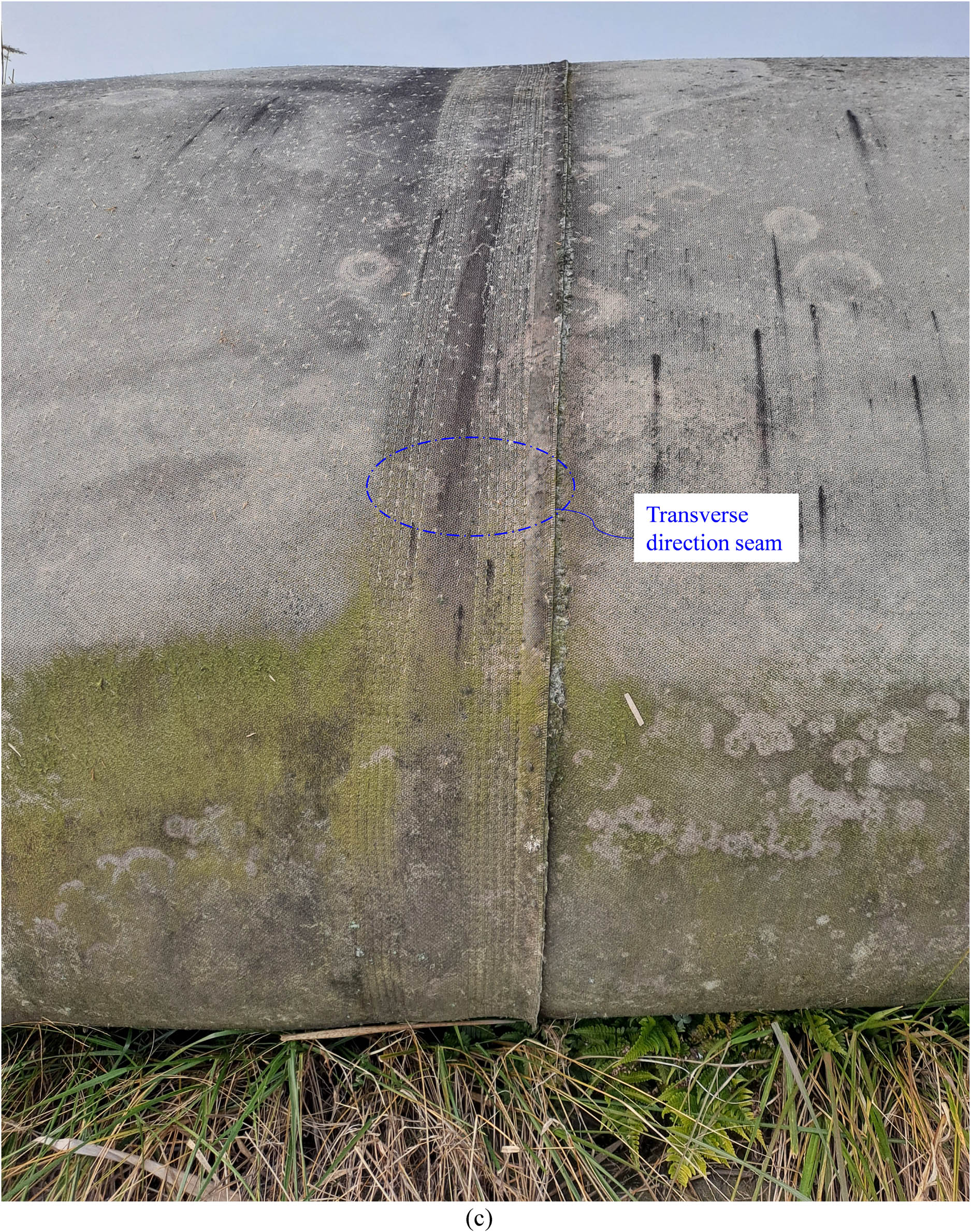
Test bed 1 and 3 current status (2023). (a) View of staged geotextile tube. (b) View of TB-1 longitudinal seam and transverse direction strip. (c) A view of TB-3 transverse direction seam.
As highlighted in the earlier section, the I-type slurry filling of TB-2 resulted in an irregular deposition of the slurry, leading to a non-uniform tube configuration after the filling process. Over an extended period, this tube was subjected to multiple cycles of sea water waves on one side of the geotextile tube, as illustrated in Figure 16(a). Consequently, the soil beneath the foundation scoured, triggering further settlement (Figure 16(b)) and causing a deviation from uniform alignment (Figure 16(c)). It is noteworthy that despite the uneven distribution of tensile forces due to these challenges, the seam of the tube remained intact (see Figure 16(d)). Remarkably, not a single stitch was broken, underscoring the importance of the two-row, six-line stitching in ensuring the long-term structural resilience of the geotextile tube.

Test bed 2 status observed during wave water action in 2017 and current status in 2023. (a) A view showing water facing side of the geotextile tube (2017). (b) Geotextile tube settlement due to scouring of foundation (2017). (c) Non-uniform longitudinal alignment view due to water wave action (2023). (d) View showing transverse direction seam (2023).
TB-4, installed with a shear key at the bottom, experienced a seam rupture during the filling process when the geotextile tube unfolded. Subsequently, another longitudinal seam failure occurred on one side of TB-4, where it faced multiple cycles of water waves, as depicted in Figure 17(b). The scouring of the foundation beneath the geotextile tube led to an additional longitudinal seam rupture. Notably, vegetation has taken root in both of the broken seams, as evidenced in Figure 17(c). Over an extended period, due to the rupture of seams on both sides, the loss of filling material from these occurrences resulted in a non-uniform profile, illustrated in Figure 17(d).

Test bed 4 status observed during wave water action in 2017 and current status in 2023. (a) A view showing sea water wave action and scouring on right side of tube (2017). (b) Scouring of foundation, resulting in broken longitudinal seam on right side of tube (2017). (c) Broken seams view & non-uniform alignment due to foundation scouring. (d) A view showing alignment (2023).
TB-5, installed in a semi-submerged condition, was discovered beneath the reclamation soil, as depicted in Figure 18(a). The two-row, six-line stitching exhibited remarkable durability, remaining intact despite the challenging conditions. This resilience was evident in Figure 18(b), where the stitching pattern remained unaffected even when subjected to construction activities, including the passage of an excavator. This observation underscores the robustness of the composite material and seam pattern, showcasing their integrity in a buried marine environment over a 10-year period.

Current status of test bed 5 (2023). (a) View showing testbed inside the reclamation soil. (b) A view of longitudinal seam.
An alignment view of the current status of TB-6 is presented in Figure 19(a), revealing a uniform longitudinal and vertical profile. Furthermore, the stitching of the longitudinal seam and the transverse reinforcement strip is found to be intact, displaying excellent integrity, as illustrated in Figure 19(b) and (c), respectively. As observed in TB-1, TB-6, assembled using seam pattern 3, also exhibits a reinforcement band effect along the transverse strip. This observation emphasizes the importance of the reinforcement strip, providing additional resistance to tensile forces along the circumference – the primary plane in the geotextile tube.

Current status of test bed 6 (2023). (a) An alignment view. (b) View of longitudinal seam. (c) View of transverse reinforcement strip stitching.
TB-6 stands out as one of the best-performing geotextile tubes formed during filling and over a 10-year period. Consequently, it can be inferred that the seam pattern 3, coupled with the T-type injection module, proves to be the most suitable in comparison to all presented cases. Considering the band reinforcement effect observed in the transverse strip, a slight modification is suggested for seam pattern 3 (L + R seam). It is recommended to increase the width of the reinforcement transverse strip from 15 to 30 cm, accompanied by the implementation of the two-row, six-line stitching (Figure 20) for future engineering practices.

Recommended pattern: longitudinal direction seam + transverse strip reinforcement, showing geo tube assembly fabrication configuration. (a) Plan view. (b) Sectional elevation. (c) Cross-sectional details.
Although the TB-6 (L + R seam) outperformed all other studied configurations, TB-2 and TB-4 were more exposed to wave action and erosion compared to TB-6 due to varying environmental conditions. Additionally, TB-4 seam ruptured during the unfolding at the shear key in the filling stage. Therefore, it is recommended to further investigate the performance of different seam types (T, L, and L + R) under consistent conditions, specifically when filled with a T-type injection module and subjected to the combined effects of wave action and foundation erosion. This will help establish guidelines for optimizing the geotextile tube’s resistance to erosion over extended durations.
The seam type for TB-1 was L + R, similar to TB-6, which was identified as the optimal seam type. In TB-1, we stacked TB-3, and a long-term band reinforcement effect was observed. Since TB-1 and TB-6 share the same L + R seam type, the extended evaluation period showed that the combination of TB-3 with TB-1 performed well under the given stress conditions. Therefore, stacking TB-3 with TB-1 does not alter the conclusion regarding the optimal seam type. It can be inferred that the L + R-seam type is also effective for the stacked geotextile tube construction.
5 Conclusions
This case study explores the performance of composite geotextile tubes assembled using different seam patterns and implemented in the Saemangeum reclamation area, South Korea. The following conclusions are drawn from the observations:
During the slurry filling stage, the T-type injection module demonstrated greater effectiveness, ensuring even slurry deposition in the lateral direction and preventing crater formation, resulting in a uniform profile. The two-row, six-line stitching exhibited reliable performance in both longitudinal and transverse directions for all TBs, except TB-4, where one row failed due to the unfolding of the geotextile tube at the shear key. This suggests that the current shear key installation design was ineffective, and further investigation into shear key design and seam type configurations is required.
A geotextile tube composed of a composite of woven and non-woven geotextiles exposed to sunlight and seawater for 10 years functioned normally, with no rupture observed during the extended duration.
Geotextile tubes assembled using seam pattern type 2 (transverse direction seam) demonstrated more stable behavior than seam pattern type 1 (longitudinally seamed) in terms of longitudinal and vertical profiles. However, seam pattern type 3 (longitudinal seam with transverse reinforcement strip) was identified as the optimal configuration, attributed to the observed band reinforcement effect along the circumference – the major plane subjected to tensile stresses of the filled material. Therefore, a longitudinal seam with a transverse reinforcement strip is recommended for long-term geotextile tube construction.
Through long-term observation of two-stage geotextile tube test construction, it was confirmed that geotextile tubes can be effectively applied to slope reinforcement, maintaining integrity, alignment, and vertical profile.
The foundation scouring of the geotextile tube led to the rupture of one of the longitudinal seams in TB-4, causing a gradual loss of slurry volume over time and resulting in a non-uniform geotextile profile. Therefore, caution is strongly recommended when constructing geotextile tubes on the coast to mitigate the risk of foundation scour.
This case study, being the first of its kind, provides valuable insights for the engineering community, serving as a foundation for future enhancements in understanding the long-term geotextile tube seam configurations’ behavior subjected to the field conditions.
-
Funding information: This research was supported by the Basic Science Research Program through the National Research Foundation of Korea (NRF) funded by the Ministry of Education (RS-2021-NR060134), Brain Korea 21 FOUR).
-
Author contributions: Hyeong-Joo Kim: project administration, funding acquisition, and conceptualization. Myoung-Soo Won: writing – review and editing, supervision, formal analysis, and conceptualization. Shamsher Sadiq: writing – original draft, visualization, investigation, and formal analysis. Tae-Woong Park: test bed preparation and visualization. Hyeong-Soo Kim: test bed preparation and visualization. Young-Chul Park: test bed preparation and visualization. Ji-Hwi Gwak: test bed preparation and visualization. Tae-Eon Kim: test bed preparation and visualization. JianBin Wang: test bed preparation and visualization. Jeong-Ho Choi: test bed preparation and visualization.
-
Conflict of interest: The authors declare that they have no known competing financial interests or personal relationships that could have appeared to influence the work reported in this paper.
References
[1] Chu J, Yan S, Li W. Innovative methods for dike construction–An overview. Geotext Geomembr 2012;30:35–42.10.1016/j.geotexmem.2011.01.008Suche in Google Scholar
[2] Saathoff F, Oumeraci H, Restall S. Australian and German experiences on the use of geotextile containers. Geotext Geomembr 2007;25:251–63.10.1016/j.geotexmem.2007.02.009Suche in Google Scholar
[3] Lee E, Douglas R. Geotextile tubes as submerged dykes for shoreline management in Malaysia. Geotext Geomembr 2012;30:8–15.10.1016/j.geotexmem.2011.01.003Suche in Google Scholar
[4] Shin E, Oh Y. Coastal erosion prevention by geotextile tube technology. Geotext Geomembr 2007;25:264–77.10.1016/j.geotexmem.2007.02.003Suche in Google Scholar
[5] Alvarez E, Rubio R, Ricalde H. Beach restoration with geotextile tubes as submerged breakwaters in Yucatan, Mexico. Geotext Geomembr 2007;25:233–41.10.1016/j.geotexmem.2007.02.005Suche in Google Scholar
[6] Corbella S, Stretch DD. Geotextile sand filled containers as coastal defence: South African experience. Geotext Geomembr 2012;35:120–30.10.1016/j.geotexmem.2012.09.004Suche in Google Scholar
[7] Restall SJ, Jackson L, Heerten G, Hornsey W. Case studies showing the growth and development of geotextile sand containers: an Australian perspective. Geotext Geomembr 2002;20:321–42.10.1016/S0266-1144(02)00030-4Suche in Google Scholar
[8] Yang Y, Wei Z, Cao G, Yang Y, Wang H, Zhuang S, et al. A case study on utilizing geotextile tubes for tailings dams construction in China. Geotext Geomembr 2019;47:187–92.10.1016/j.geotexmem.2018.12.007Suche in Google Scholar
[9] Das UK. A case study on performance of Jia Bharali River Bank protection measure using geotextile bags. Int J Geosynth Ground Eng 2016;2:1–9.10.1007/s40891-016-0052-8Suche in Google Scholar
[10] Yee T, Zengerink E, Choi J. Geotextile tube application for Incheon Bridge project, Korea. Proceedings of the CEDA dredging days 2007 conference, Rotterdam, Netherlands. 2007.Suche in Google Scholar
[11] Cho S, Jeon B, Park S, Yoon H. Geotextile tube application as the cofferdam at the foreshore with large tidal range for Incheon bridge project. Geosynthetics in Civil and Environmental Engineering: Geosynthetics Asia 2008 Proceedings of the 4th Asian Regional Conference on Geosynthetics in Shanghai, China. Springer; 2009. p. 591–6.10.1007/978-3-540-69313-0_110Suche in Google Scholar
[12] Moo-Young HK, Gaffney DA, Mo X. Testing procedures to assess the viability of dewatering with geotextile tubes. Geotext Geomembr 2002;20:289–303.10.1016/S0266-1144(02)00028-6Suche in Google Scholar
[13] Koerner GR, Koerner RM. Geotextile tube assessment using a hanging bag test. Geotext Geomembr 2006;24:129–37.10.1016/j.geotexmem.2005.02.006Suche in Google Scholar
[14] Recio J, Oumeraci H. Hydraulic permeability of structures made of geotextile sand containers: Laboratory tests and conceptual model. Geotext Geomembr 2008;26:473–87.10.1016/j.geotexmem.2008.05.006Suche in Google Scholar
[15] Cantré S, Saathoff F. Design parameters for geosynthetic dewatering tubes derived from pressure filtration tests. Geosynth Int 2011;18:90–103.10.1680/gein.2011.18.3.90Suche in Google Scholar
[16] Weggel JR, Dortch J, Gaffney D. Analysis of fluid discharge from a hanging geotextile bag. Geotext Geomembr 2011;29:65–73.10.1016/j.geotexmem.2010.06.011Suche in Google Scholar
[17] Malík J. Some problems connected with 2D modeling of geosynthetic tubes. Nonlinear Anal: Real World Appl. 2009;10:810–23.10.1016/j.nonrwa.2007.11.009Suche in Google Scholar
[18] Leshchinsky D, Leshchinsky O, Ling HI, Gilbert PA. Geosynthetic tubes for confining pressurized slurry: some design aspects. J Geotech Eng 1996;122:682–90.10.1061/(ASCE)0733-9410(1996)122:8(682)Suche in Google Scholar
[19] Plaut RH, Suherman S. Two-dimensional analysis of geosynthetic tubes. Acta Mech 1998;129:207–18.10.1007/BF01176746Suche in Google Scholar
[20] Kim D-J, Kim S-C, Lee J-S, Byun Y-H, Kang B-Y. Internal strength characterization of geotextile tube using miniature cone. Ocean Eng 2022;266:113157.10.1016/j.oceaneng.2022.113157Suche in Google Scholar
[21] Son DG, Byun Y-H. Shear strength characteristics of two-layer geotextile reinforced with flowable fill. Constr Build Mater 2023;367:130207.10.1016/j.conbuildmat.2022.130207Suche in Google Scholar
[22] Carneiro JR, Morais M, de Lurdes Lopes M. Degradation of polypropylene geotextiles with different chemical stabilisations in marine environments. Constr Build Mater 2018;165:877–86.10.1016/j.conbuildmat.2018.01.067Suche in Google Scholar
[23] Man X-L, Shu Y-M, Yu C-L, Hao X-H, Li S-P. Effect of cyclic wave loading on scouring stability of geotube dams. Ocean Eng 2018;152:1–5.10.1016/j.oceaneng.2018.01.040Suche in Google Scholar
[24] Zhu Y, Xie L, Su T-C. Flow characteristics on the leeside of a geotextile mattress with floating plate. Ocean Eng 2022;265:112624.10.1016/j.oceaneng.2022.112624Suche in Google Scholar
[25] Kim H-J, Won M-S, Sadiq S, Park TW, Kim HS, Jeong YS, et al. Introduction to a novel geotextile tube connection construction method: A case study of test site and field application. Geotext Geomembr. 2024;52(4):626–34.10.1016/j.geotexmem.2024.03.005Suche in Google Scholar
[26] Kim H-J, Won M-S, Sadiq S, Park TW, Kim HS, Ryu YT, et al. Observations from opening of a novel geotextile tube connection in field test site. Geotext Geomembr 2025;53:311–7.10.1016/j.geotexmem.2024.10.001Suche in Google Scholar
[27] Won M-S, Kim HJ, Shamshe S, Gwak JH. A study on the long-term tensile strength properties of the geotextile tubes. J Mar Sci Eng. 2025;13(5):985.10.3390/jmse13050985Suche in Google Scholar
© 2025 the author(s), published by De Gruyter
This work is licensed under the Creative Commons Attribution 4.0 International License.
Artikel in diesem Heft
- Research Articles
- Seismic response and damage model analysis of rocky slopes with weak interlayers
- Multi-scenario simulation and eco-environmental effect analysis of “Production–Living–Ecological space” based on PLUS model: A case study of Anyang City
- Remote sensing estimation of chlorophyll content in rape leaves in Weibei dryland region of China
- GIS-based frequency ratio and Shannon entropy modeling for landslide susceptibility mapping: A case study in Kundah Taluk, Nilgiris District, India
- Natural gas origin and accumulation of the Changxing–Feixianguan Formation in the Puguang area, China
- Spatial variations of shear-wave velocity anomaly derived from Love wave ambient noise seismic tomography along Lembang Fault (West Java, Indonesia)
- Evaluation of cumulative rainfall and rainfall event–duration threshold based on triggering and non-triggering rainfalls: Northern Thailand case
- Pixel and region-oriented classification of Sentinel-2 imagery to assess LULC dynamics and their climate impact in Nowshera, Pakistan
- The use of radar-optical remote sensing data and geographic information system–analytical hierarchy process–multicriteria decision analysis techniques for revealing groundwater recharge prospective zones in arid-semi arid lands
- Effect of pore throats on the reservoir quality of tight sandstone: A case study of the Yanchang Formation in the Zhidan area, Ordos Basin
- Hydroelectric simulation of the phreatic water response of mining cracked soil based on microbial solidification
- Spatial-temporal evolution of habitat quality in tropical monsoon climate region based on “pattern–process–quality” – a case study of Cambodia
- Early Permian to Middle Triassic Formation petroleum potentials of Sydney Basin, Australia: A geochemical analysis
- Micro-mechanism analysis of Zhongchuan loess liquefaction disaster induced by Jishishan M6.2 earthquake in 2023
- Prediction method of S-wave velocities in tight sandstone reservoirs – a case study of CO2 geological storage area in Ordos Basin
- Ecological restoration in valley area of semiarid region damaged by shallow buried coal seam mining
- Hydrocarbon-generating characteristics of Xujiahe coal-bearing source rocks in the continuous sedimentary environment of the Southwest Sichuan
- Hazard analysis of future surface displacements on active faults based on the recurrence interval of strong earthquakes
- Structural characterization of the Zalm district, West Saudi Arabia, using aeromagnetic data: An approach for gold mineral exploration
- Research on the variation in the Shields curve of silt initiation
- Reuse of agricultural drainage water and wastewater for crop irrigation in southeastern Algeria
- Assessing the effectiveness of utilizing low-cost inertial measurement unit sensors for producing as-built plans
- Analysis of the formation process of a natural fertilizer in the loess area
- Machine learning methods for landslide mapping studies: A comparative study of SVM and RF algorithms in the Oued Aoulai watershed (Morocco)
- Chemical dissolution and the source of salt efflorescence in weathering of sandstone cultural relics
- Molecular simulation of methane adsorption capacity in transitional shale – a case study of Longtan Formation shale in Southern Sichuan Basin, SW China
- Evolution characteristics of extreme maximum temperature events in Central China and adaptation strategies under different future warming scenarios
- Estimating Bowen ratio in local environment based on satellite imagery
- 3D fusion modeling of multi-scale geological structures based on subdivision-NURBS surfaces and stratigraphic sequence formalization
- Comparative analysis of machine learning algorithms in Google Earth Engine for urban land use dynamics in rapidly urbanizing South Asian cities
- Study on the mechanism of plant root influence on soil properties in expansive soil areas
- Simulation of seismic hazard parameters and earthquakes source mechanisms along the Red Sea rift, western Saudi Arabia
- Tectonics vs sedimentation in foredeep basins: A tale from the Oligo-Miocene Monte Falterona Formation (Northern Apennines, Italy)
- Investigation of landslide areas in Tokat-Almus road between Bakımlı-Almus by the PS-InSAR method (Türkiye)
- Predicting coastal variations in non-storm conditions with machine learning
- Cross-dimensional adaptivity research on a 3D earth observation data cube model
- Geochronology and geochemistry of late Paleozoic volcanic rocks in eastern Inner Mongolia and their geological significance
- Spatial and temporal evolution of land use and habitat quality in arid regions – a case of Northwest China
- Ground-penetrating radar imaging of subsurface karst features controlling water leakage across Wadi Namar dam, south Riyadh, Saudi Arabia
- Rayleigh wave dispersion inversion via modified sine cosine algorithm: Application to Hangzhou, China passive surface wave data
- Fractal insights into permeability control by pore structure in tight sandstone reservoirs, Heshui area, Ordos Basin
- Debris flow hazard characteristic and mitigation in Yusitong Gully, Hengduan Mountainous Region
- Research on community characteristics of vegetation restoration in hilly power engineering based on multi temporal remote sensing technology
- Identification of radial drainage networks based on topographic and geometric features
- Trace elements and melt inclusion in zircon within the Qunji porphyry Cu deposit: Application to the metallogenic potential of the reduced magma-hydrothermal system
- Pore, fracture characteristics and diagenetic evolution of medium-maturity marine shales from the Silurian Longmaxi Formation, NE Sichuan Basin, China
- Study of the earthquakes source parameters, site response, and path attenuation using P and S-waves spectral inversion, Aswan region, south Egypt
- Source of contamination and assessment of potential health risks of potentially toxic metal(loid)s in agricultural soil from Al Lith, Saudi Arabia
- Regional spatiotemporal evolution and influencing factors of rural construction areas in the Nanxi River Basin via GIS
- An efficient network for object detection in scale-imbalanced remote sensing images
- Effect of microscopic pore–throat structure heterogeneity on waterflooding seepage characteristics of tight sandstone reservoirs
- Environmental health risk assessment of Zn, Cd, Pb, Fe, and Co in coastal sediments of the southeastern Gulf of Aqaba
- A modified Hoek–Brown model considering softening effects and its applications
- Evaluation of engineering properties of soil for sustainable urban development
- The spatio-temporal characteristics and influencing factors of sustainable development in China’s provincial areas
- Application of a mixed additive and multiplicative random error model to generate DTM products from LiDAR data
- Gold vein mineralogy and oxygen isotopes of Wadi Abu Khusheiba, Jordan
- Prediction of surface deformation time series in closed mines based on LSTM and optimization algorithms
- 2D–3D Geological features collaborative identification of surrounding rock structural planes in hydraulic adit based on OC-AINet
- Spatiotemporal patterns and drivers of Chl-a in Chinese lakes between 1986 and 2023
- Land use classification through fusion of remote sensing images and multi-source data
- Nexus between renewable energy, technological innovation, and carbon dioxide emissions in Saudi Arabia
- Analysis of the spillover effects of green organic transformation on sustainable development in ethnic regions’ agriculture and animal husbandry
- Factors impacting spatial distribution of black and odorous water bodies in Hebei
- Large-scale shaking table tests on the liquefaction and deformation responses of an ultra-deep overburden
- Impacts of climate change and sea-level rise on the coastal geological environment of Quang Nam province, Vietnam
- Reservoir characterization and exploration potential of shale reservoir near denudation area: A case study of Ordovician–Silurian marine shale, China
- Seismic prediction of Permian volcanic rock reservoirs in Southwest Sichuan Basin
- Application of CBERS-04 IRS data to land surface temperature inversion: A case study based on Minqin arid area
- Geological characteristics and prospecting direction of Sanjiaoding gold mine in Saishiteng area
- Research on the deformation prediction model of surrounding rock based on SSA-VMD-GRU
- Geochronology, geochemical characteristics, and tectonic significance of the granites, Menghewula, Southern Great Xing’an range
- Hazard classification of active faults in Yunnan base on probabilistic seismic hazard assessment
- Characteristics analysis of hydrate reservoirs with different geological structures developed by vertical well depressurization
- Estimating the travel distance of channelized rock avalanches using genetic programming method
- Landscape preferences of hikers in Three Parallel Rivers Region and its adjacent regions by content analysis of user-generated photography
- New age constraints of the LGM onset in the Bohemian Forest – Central Europe
- Characteristics of geological evolution based on the multifractal singularity theory: A case study of Heyu granite and Mesozoic tectonics
- Soil water content and longitudinal microbiota distribution in disturbed areas of tower foundations of power transmission and transformation projects
- Oil accumulation process of the Kongdian reservoir in the deep subsag zone of the Cangdong Sag, Bohai Bay Basin, China
- Investigation of velocity profile in rock–ice avalanche by particle image velocimetry measurement
- Optimizing 3D seismic survey geometries using ray tracing and illumination modeling: A case study from Penobscot field
- Sedimentology of the Phra That and Pha Daeng Formations: A preliminary evaluation of geological CO2 storage potential in the Lampang Basin, Thailand
- Improved classification algorithm for hyperspectral remote sensing images based on the hybrid spectral network model
- Map analysis of soil erodibility rates and gully erosion sites in Anambra State, South Eastern Nigeria
- Identification and driving mechanism of land use conflict in China’s South-North transition zone: A case study of Huaihe River Basin
- Evaluation of the impact of land-use change on earthquake risk distribution in different periods: An empirical analysis from Sichuan Province
- A test site case study on the long-term behavior of geotextile tubes
- An experimental investigation into carbon dioxide flooding and rock dissolution in low-permeability reservoirs of the South China Sea
- Detection and semi-quantitative analysis of naphthenic acids in coal and gangue from mining areas in China
- Comparative effects of olivine and sand on KOH-treated clayey soil
- YOLO-MC: An algorithm for early forest fire recognition based on drone image
- Earthquake building damage classification based on full suite of Sentinel-1 features
- Potential landslide detection and influencing factors analysis in the upper Yellow River based on SBAS-InSAR technology
- Assessing green area changes in Najran City, Saudi Arabia (2013–2022) using hybrid deep learning techniques
- An advanced approach integrating methods to estimate hydraulic conductivity of different soil types supported by a machine learning model
- Hybrid methods for land use and land cover classification using remote sensing and combined spectral feature extraction: A case study of Najran City, KSA
- Streamlining digital elevation model construction from historical aerial photographs: The impact of reference elevation data on spatial accuracy
- Analysis of urban expansion patterns in the Yangtze River Delta based on the fusion impervious surfaces dataset
- A metaverse-based visual analysis approach for 3D reservoir models
- Late Quaternary record of 100 ka depositional cycles on the Larache shelf (NW Morocco)
- Integrated well-seismic analysis of sedimentary facies distribution: A case study from the Mesoproterozoic, Ordos Basin, China
- Study on the spatial equilibrium of cultural and tourism resources in Macao, China
- Urban road surface condition detecting and integrating based on the mobile sensing framework with multi-modal sensors
- Application of improved sine cosine algorithm with chaotic mapping and novel updating methods for joint inversion of resistivity and surface wave data
- The synergistic use of AHP and GIS to assess factors driving forest fire potential in a peat swamp forest in Thailand
- Dynamic response analysis and comprehensive evaluation of cement-improved aeolian sand roadbed
- Rock control on evolution of Khorat Cuesta, Khorat UNESCO Geopark, Northeastern Thailand
- Gradient response mechanism of carbon storage: Spatiotemporal analysis of economic-ecological dimensions based on hybrid machine learning
- Comparison of several seismic active earth pressure calculation methods for retaining structures
- Mantle dynamics and petrogenesis of Gomer basalts in the Northwestern Ethiopia: A geochemical perspective
- Study on ground deformation monitoring in Xiong’an New Area from 2021 to 2023 based on DS-InSAR
- Paleoenvironmental characteristics of continental shale and its significance to organic matter enrichment: Taking the fifth member of Xujiahe Formation in Tianfu area of Sichuan Basin as an example
- Equipping the integral approach with generalized least squares to reconstruct relict channel profile and its usage in the Shanxi Rift, northern China
- InSAR-driven landslide hazard assessment along highways in hilly regions: A case-based validation approach
- Attribution analysis of multi-temporal scale surface streamflow changes in the Ganjiang River based on a multi-temporal Budyko framework
- Maps analysis of Najran City, Saudi Arabia to enhance agricultural development using hybrid system of ANN and multi-CNN models
- Hybrid deep learning with a random forest system for sustainable agricultural land cover classification using DEM in Najran, Saudi Arabia
- Long-term evolution patterns of groundwater depth and lagged response to precipitation in a complex aquifer system: Insights from Huaibei Region, China
- Remote sensing and machine learning for lithology and mineral detection in NW, Pakistan
- Spatial–temporal variations of NO2 pollution in Shandong Province based on Sentinel-5P satellite data and influencing factors
- Numerical modeling of geothermal energy piles with sensitivity and parameter variation analysis of a case study
- Stability analysis of valley-type upstream tailings dams using a 3D model
- Variation characteristics and attribution analysis of actual evaporation at monthly time scale from 1982 to 2019 in Jialing River Basin, China
- Investigating machine learning and statistical approaches for landslide susceptibility mapping in Minfeng County, Xinjiang
- Investigating spatiotemporal patterns for comprehensive accessibility of service facilities by location-based service data in Nanjing (2016–2022)
- A pre-treatment method for particle size analysis of fine-grained sedimentary rocks, Bohai Bay Basin, China
- Study on the formation mechanism of the hard-shell layer of liquefied silty soil
- Comprehensive analysis of agricultural CEE: Efficiency assessment, mechanism identification, and policy response – A case study of Anhui Province
- Simulation study on the damage and failure mechanism of the surrounding rock in sanded dolomite tunnels
- Towards carbon neutrality: Spatiotemporal evolution and key influences on agricultural ecological efficiency in Northwest China
- High-frequency cycles drive the cyclical enrichment of oil in porous carbonate reservoirs: A case study of the Khasib Formation in E Oilfield, Mesopotamian Basin, Iraq
- Reconstruction of digital core models of granular rocks using mathematical morphology
- Spatial–temporal differentiation law of habitat quality and its driving mechanism in the typical plateau areas of the Loess Plateau in the recent 30 years
- A machine-learning-based approach to predict potential oil sites: Conceptual framework and experimental evaluation
- Effects of landscape pattern change on waterbird diversity in Xianghai Nature Reserve
- Research on intelligent classification method of highway tunnel surrounding rock classification based on parameters while drilling
- River morphology and tectono-sedimentary analysis of a shallow river delta: A case study of Putaohua oil layer in Saertu oilfield (L. Cretaceous), China
- Dynamic change in quarterly FVC of urban parks based on multi-spectral UAV images: A case study of people’s park and harmony park in Xinxiang, China
- Review Articles
- Humic substances influence on the distribution of dissolved iron in seawater: A review of electrochemical methods and other techniques
- Applications of physics-informed neural networks in geosciences: From basic seismology to comprehensive environmental studies
- Ore-controlling structures of granite-related uranium deposits in South China: A review
- Shallow geological structure features in Balikpapan Bay East Kalimantan Province – Indonesia
- A review on the tectonic affinity of microcontinents and evolution of the Proto-Tethys Ocean in Northeastern Tibet
- Advancements in machine learning applications for mineral prospecting and geophysical inversion: A review
- Special Issue: Natural Resources and Environmental Risks: Towards a Sustainable Future - Part II
- Depopulation in the Visok micro-region: Toward demographic and economic revitalization
- Special Issue: Geospatial and Environmental Dynamics - Part II
- Advancing urban sustainability: Applying GIS technologies to assess SDG indicators – a case study of Podgorica (Montenegro)
- Spatiotemporal and trend analysis of common cancers in men in Central Serbia (1999–2021)
- Minerals for the green agenda, implications, stalemates, and alternatives
- Spatiotemporal water quality analysis of Vrana Lake, Croatia
- Functional transformation of settlements in coal exploitation zones: A case study of the municipality of Stanari in Republic of Srpska (Bosnia and Herzegovina)
- Hypertension in AP Vojvodina (Northern Serbia): A spatio-temporal analysis of patients at the Institute for Cardiovascular Diseases of Vojvodina
- Regional patterns in cause-specific mortality in Montenegro, 1991–2019
- Spatio-temporal analysis of flood events using GIS and remote sensing-based approach in the Ukrina River Basin, Bosnia and Herzegovina
- Flash flood susceptibility mapping using LiDAR-Derived DEM and machine learning algorithms: Ljuboviđa case study, Serbia
- Geocultural heritage as a basis for geotourism development: Banjska Monastery, Zvečan (Serbia)
- Assessment of groundwater potential zones using GIS and AHP techniques – A case study of the zone of influence of Kolubara Mining Basin
- Impact of the agri-geographical transformation of rural settlements on the geospatial dynamics of soil erosion intensity in municipalities of Central Serbia
- Where faith meets geomorphology: The cultural and religious significance of geodiversity explored through geospatial technologies
- Applications of local climate zone classification in European cities: A review of in situ and mobile monitoring methods in urban climate studies
- Complex multivariate water quality impact assessment on Krivaja River
- Ionization hotspots near waterfalls in Eastern Serbia’s Stara Planina Mountain
- Shift in landscape use strategies during the transition from the Bronze age to Iron age in Northwest Serbia
- Assessing the geotourism potential of glacial lakes in Plav, Montenegro: A multi-criteria assessment by using the M-GAM model
- Flash flood potential index at national scale: Susceptibility assessment within catchments
- SWAT modelling and MCDM for spatial valuation in small hydropower planning
- Disaster risk perception and local resilience near the “Duboko” landfill: Challenges of governance, management, trust, and environmental communication in Serbia