Structural characterization of the Zalm district, West Saudi Arabia, using aeromagnetic data: An approach for gold mineral exploration
-
Hassan Alzahrani


Abstract
The Zalm district in western Saudi Arabia has drawn significant attention from those interested in exploring for gold mineralization. In the present study, the structural framework and major structural trends that most likely control the distribution of the gold mineral deposits in the Zalm district are interpreted using aeromagnetic data. For this purpose, the aeromagnetic data were subjected to enhancement filters to make the structural interpretation of the data easier. In this respect, the data were reduced to the north magnetic pole and processed through two enhancement filters: the analytical signal (AS) and the first vertical derivative (1VD). Lineament analysis of aeromagnetic maps suggests that three major fault sets dissected the Zalm district trending in the northwest (NW), northeast (NE), and north-south (NS) directions. These faults likely affected the mineralization occurrences in the Zalm district and could serve as important structural conduits for hydrothermal fluid channeling. Based on the current results, four localities were identified as promising for additional mineral resource investigation. These localities are delimited and dissected by the NW, NE, and NS faulting and are intruded by a series of felsic and mafic–ultramafic intrusions. It is likely that, in similar to Bi'r Tawilah where the location is structurally controlled by NW and NS faulting, the interpreted felsic and mafic served as sources of mineralizing fluids which remobilized the ore in the district by channeling through the faults. Three of the suggested localities, one lying in close proximity to Zalm city and two along the Rada and Nabitah fault zones, are characterized by high magnetic anomalies, indicating the presence of ultramafic and volcanic rocks that most likely host mineralization. The fourth locality situated in the central part of the district is marked by an elongated N–S low magnetic anomaly, interpreted as felsic diorite and granite rocks delimited by N–S faulting. To accurately detect mineral resources in the selected zones, additional comprehensive and in-depth geological and geophysical research are recommended.
1 Introduction
The Arabian Shield is home to numerous gold occurrences, some of which are significant economically (e.g., Mahd Ad Dahab, Ad Duwayhi, and Bi'r Tawilah). In western Saudi Arabia, the Zalm district has drawn special attention for gold deposit exploration and mining. The Saudi Mining Company (Ma’aden) has initiated a comprehensive gold exploration campaign in this district. A number of studies have examined the lithology and mineral occurrences in the Zalm district [1,2,3,4,5,6,7,8].
Current and future investigations into gold mineralization in the Zalm area will greatly benefit from a closer examination of the link between tectonics and ore genesis. In this field, aeromagnetic data effectively aid in defining the favorable mineral localization structures, including rock properties, faults, lineaments, and shear zones [9,10,11,12]. Gobashy et al. [13] applied a combination of digital magnetic filters to a well-known Au mineralization zone to delineate gold mineralization sites enhancing the identification of gold prospects using magnetic data. Eldougdoug et al. [14] employed geophysical techniques to link gold mineralization with the altered ultramafic rocks associated with faulting. In the present study, aeromagnetic data and applied filtering techniques are used to delineate favorable areas of mineral deposits and potential pathways for ascending hydrothermal fluids focusing particularly on structural lineaments, faults, and shear zones in the Zalm region. This region is located east of the Nabitah suture belt and west of the Afif terrane, between Latitude 22°00′ N and 23°00′ N and Longitude 42°00′ and 43°30′E (Figure 1). The ongoing and future exploration of gold mineralization in Zalm district will benefit greatly from this study.
![Figure 1
The Arabian Shield geologic map showing the tectonic terranes and their boundaries [15].](/document/doi/10.1515/geo-2022-0764/asset/graphic/j_geo-2022-0764_fig_001.jpg)
The Arabian Shield geologic map showing the tectonic terranes and their boundaries [15].
2 Geological overview
The formation of the 40–100 km thick lithosphere of the Arabian Shield was driven by the division of the Arabian Shield into distinct tectonostratigraphic terranes (Figure 1) composed of Tonian (1,000–850 Ma) and Cryogenian (850–650 Ma) volcanic and plutonic rocks [16,17]. Ophiolite-lined sutures (e.g., Yanbu, Bi'r Umq, Nabitah, and Al Amar) divide these terranes (Figure 1), which were joined by accretionary process [16,18,19,20]. According to Stoeser and Camp [19], the Afif terrane is a complex assemblage of volcanic-arc periods overlain by 710 Ma volcano-sedimentary stages in deep basins. The Zalm region (Figure 2) is situated on the western side of the Afif terrane [21]. This region has drawn the interest of numerous earth scientists due to its historic gold and tungsten mine workings and gold mineralization, particularly near the Nabitah suture zone [21,22,23,24,25,26,27,28,29,30,31,32,33]. Based on the host rocks and structural setting, primary gold mineralization can be divided into three basic categories, according to Harbi et al. [25]. The first category is connected with sedimentary sequences formed by volcanics, and includes significant sulfide deposits [26,27,28,34]. The second category as stated by Al Shanti [34] is spatially connected with carbonatized ophiolitic ultramafic rocks. The third category is widespread east of the Nabitah suture zone and west of the Afif terrane, where late- to post-tectonic (640–610 Ma) diorite–granite plutons are found [21,29,30,31,32]. Gold deposits in the Zalm district are controlled by intraplate structural and/or magnetic activity [33]. The Nabitah suture belt, near the Zalm area, is characterized by prominent NS and NW structural trends [35]. The main NW-oriented faults are associated with the Najd fault system, which was active during the most recent tectonic event of the Pan-African orogeny that affected the Arabian Shield [35]. According to previous studies, the Najd fault system was crucial in the formation of the gold deposits in the Arabian Shield as well as those in the Zalm area [1,36,37,38]. The importance of Najd faulting in the genesis of gold ores in the Zalm region was confirmed by the structural data obtained by Agar [1], who analyzed the movement vectors of the Najd fault system at the Zalm district, including the Bi'r Tawilah deposit area. The main shear components of the regional fault system in this area are thick, barren quartz veins trending in the NW and NE directions.
![Figure 2
A generalized geologic map of Zalm district [1].](/document/doi/10.1515/geo-2022-0764/asset/graphic/j_geo-2022-0764_fig_002.jpg)
A generalized geologic map of Zalm district [1].
3 Data and methods
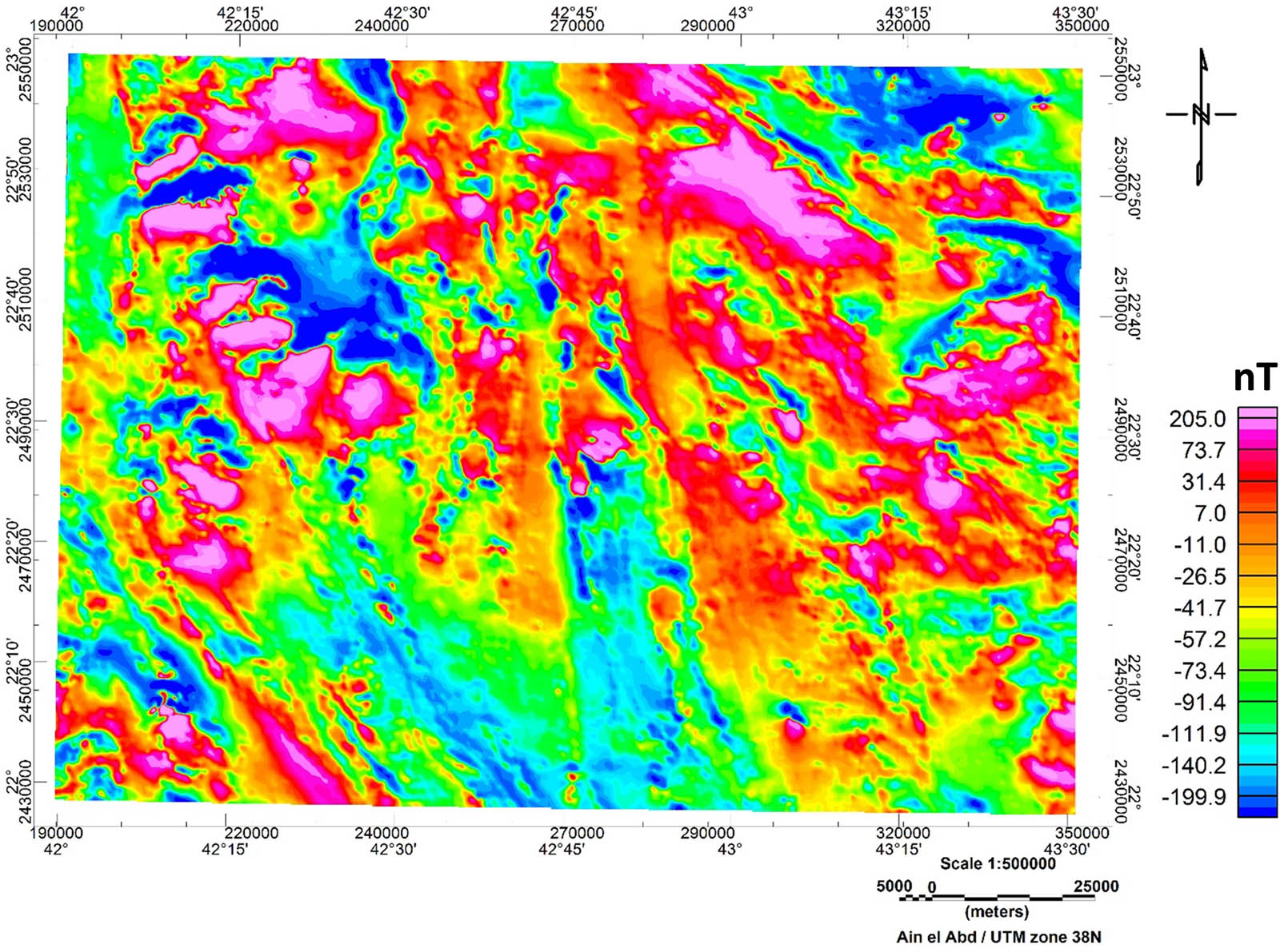
The aeromagnetic data of the Zalm district was collected as part of government-sponsored aeromagnetic survey that covered central and western Saudi Arabia between 1962 and 1983. A line spacing of 800 m and an altitude of 150–300 m above ground level was used for most of the Arabian Shield data collection. To create the total magnetic intensity (TMI) map for the entire region, the surveys were fully re-leveled using specialized techniques, combined, and gridded at 200 m intervals. Since the processing eliminated almost all leveling errors, resulting in only slight discontinuities at the survey boundaries, no upward continuation was used [39,40,41].
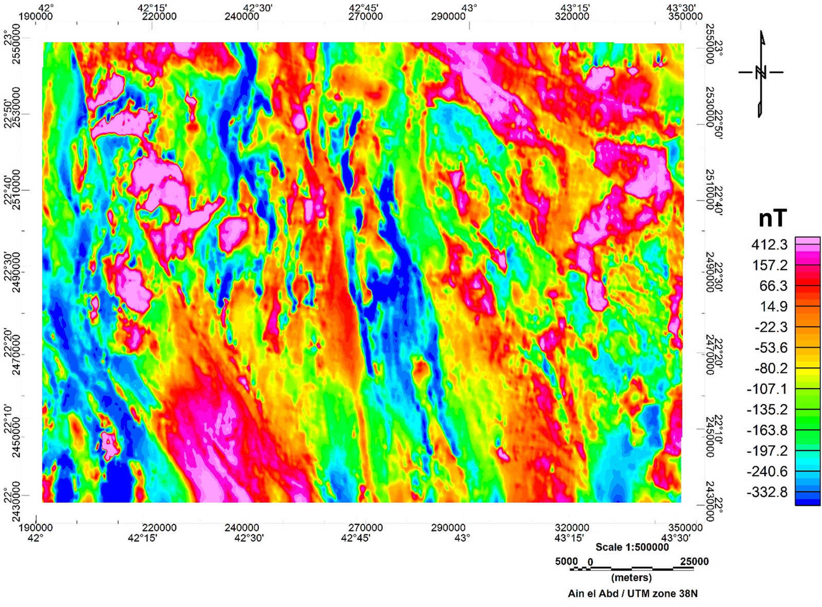
The obtained TMI gridded datasets (Figure 3) were further processed by reducing them to the magnetic pole using the estimated magnetic inclination and declination (32.294° and 2.297°, respectively) for the study area (Figure 4). Reduced to the magnetic Pole (RTP) transformation was conducted using Fourier Domain filtering provided by MAGMAP, Geosoft 8.3.3 package [42] after which the residual field was produced. Thereafter, other forms of processing and enhancement filtering techniques were applied. The RTP grid was subjected to two enhancement filters; the first vertical derivative (1VD, Figure 5) and the analytical signal (AS, Figure 6). Nabighian [43] proposed the 1VD to enhance shallow features with their boundaries and associated lineaments by using 3D Hilbert transforms in the x and y directions. This approach highlights and maps shallower sources by emphasizing short-wavelength anomalies over large ones. By combining the vertical and horizontal gradients of the magnetic anomaly, the AS [44] produces a maximum directly over source bodies and their edges [45]. This filter emphasizes short-wavelength anomalies and is used to highlight discontinuities and reveal the anomaly texture [46]. Thus, to identify that the litho-structural features are related anomalous zones that may be useful in delineating the mineralization occurrences, this study employed first-order vertical derivatives and AS techniques.
TMI map of the Zalm district, west Saudi Arabia.
RTP map of the Zalm district, west Saudi Arabia.
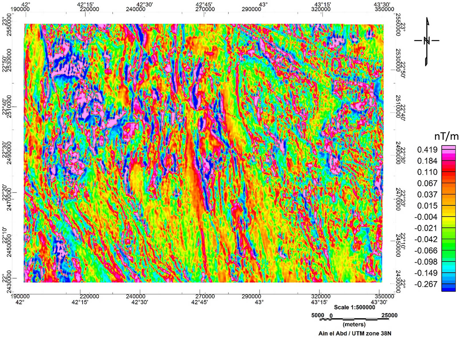
1VD map of the Zalm district, west Saudi Arabia.
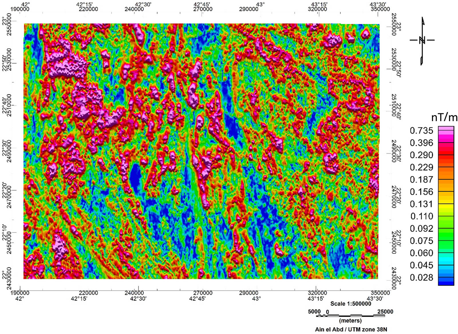
AS map of the Zalm district, west Saudi Arabia.
In this study, the minimum curvature method as described by Briggs and Swain [47,48] was used for data gridding. This method interpolates the data by fitting a two-dimensional surface to the raw XYZ data in a way that minimizes the surface curvature.
4 Results and discussion
In the current study, 1VD and AS filtering techniques were applied to process and evaluate aeromagnetic data (Figure 4) of the Zalm district in order to facilitate structural interpretation. The near-surface structures, such as faults, are well-represented by the 1VD map (Figure 5), where the filter accentuates short-wavelength anomalies responsible for shallow sources while suppressing long-wavelength ones. Additionally the AS map (Figure 6) draws attention to the variance in the magnetization of the magnetic sources in the study area. Unlike the 1VD map (Figure 5), the AS map allows for the accurate identification and mapping of various rock units, considering both their mineralogical compositions and depths.
According to Telford et al. [49], strong magnetic anomalies are typically associated with rocks rich in ferromagnetic minerals and low in felsic minerals. Consequently, high magnetic anomaly areas around the Zalm city, the Rada fault zone and the Nabitah fault zone, as shown in the interpreted RTP map (Figure 7), can be correlated to the ultramafic and volcanic rocks that contain mineralization sources [50,51,52,53,54]. According to previous literature [22,23,24,34], gold deposits are located near the ultramafic rocks of the Zalm district which are associated with the Nabitah and Rada suture zones. However, the central zone of the study is characterized by N–S trending low magnetic anomalies (Figure 7) that may correlate with felsic diorite, granodiorite, and granite zones bounded by the N–S faulting [8]. According to Surour et al. [8], these felsic rocks hosting sulfide gold ores with the intrusion-related Bi'r Tawilah gold mineralization is a notable example of these deposits [30,53].
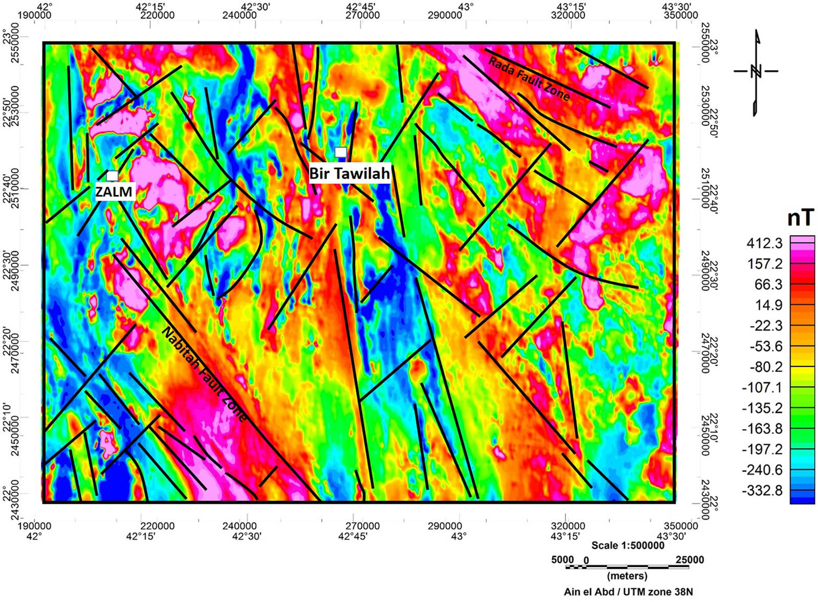
RTP map with delineated structural lineaments of the Zalm district, west Saudi Arabia.
A structural lineament map was constructed (Figure 8), based on the examination of aeromagnetic maps (Figures 7, 9, and 10). Using the several filtering techniques, especially the 1VD (Figure 9) and AS (Figure 10), numerous faults were delineated. The three dominant faulting systems in the area – the NW, NE, and NS faulting systems – are represented by lineaments traced from RTP, 1VD, and AS maps (Figure 10). This result is consistent with the structural data from the study by Agar [1] who analyzed the fault system at the Zalm district and with Surour et al. [8], who hypothesized that the N-S faulting system serves as a significant conduit for channeling hydrothermal fluids, based on mineralogical and microstructural data. Surour et al. [8] concluded that the major NW-Najd faulting system, which significantly affects the Zalm district [55–57], is responsible for all shears and conjugate fractures at the mineralization zone. Surour et al. [8] further concluded that the mineralization occurrences in the Zalm region appear clearly associated with the NW-trending shears and the NS slip faulting.
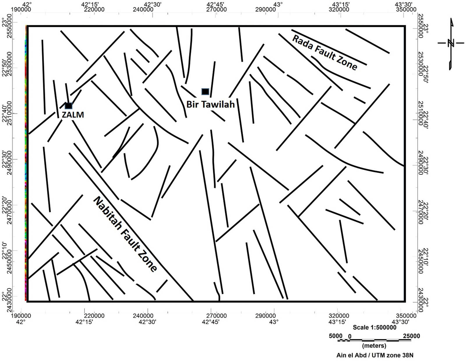
A map of the vectorization structural lineaments of the Zalm district, west Saudi Arabia.
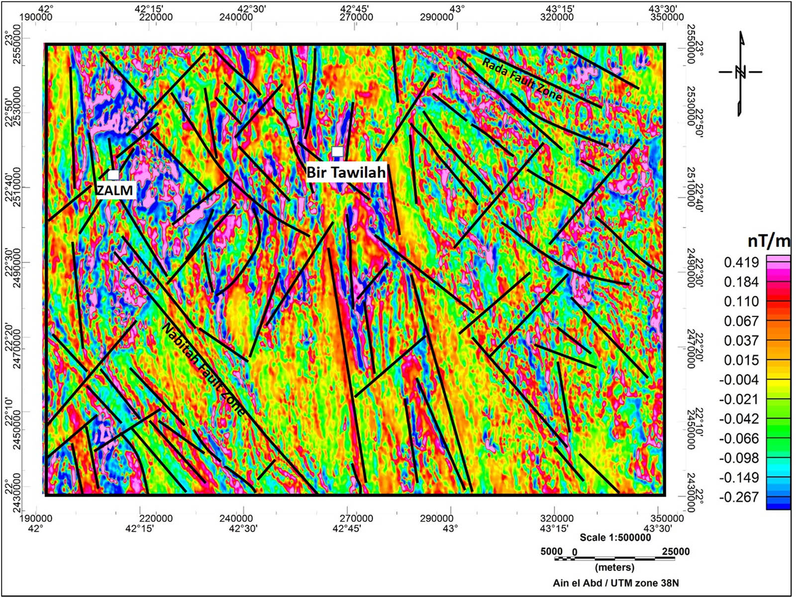
1VD map of magnetic data with mapped structural lineaments of the Zalm district, west Saudi Arabia.
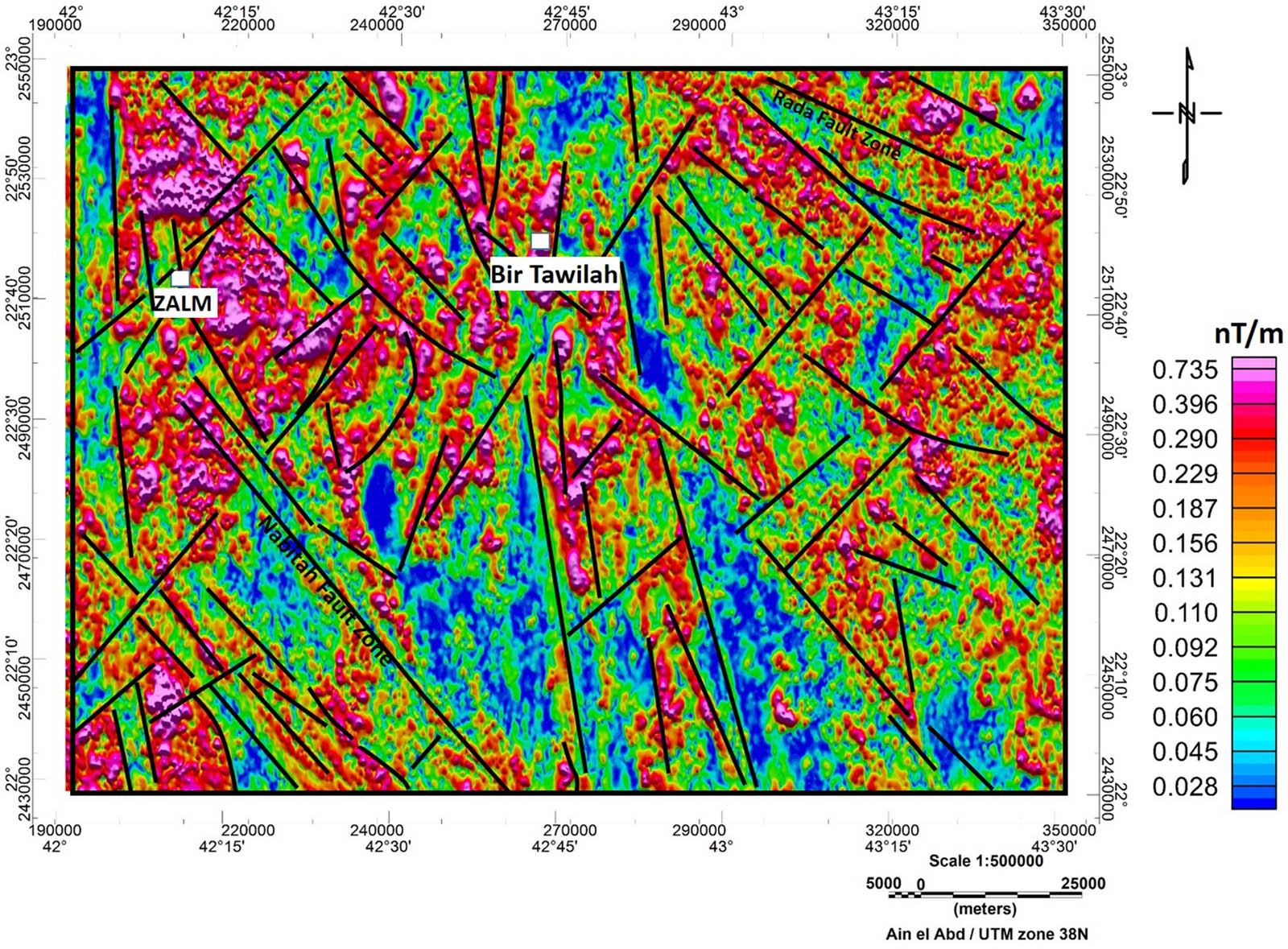
AS map of magnetic data with mapped structural lineaments of the Zalm district, west Saudi Arabia.
According to Surour et al. [8], the interpreted NW and NS lineament zones act as channels for hydrothermal fluids migrating and reacting with the rock formation, resulting in subsequent alteration. The interpreted lineaments with high complexity trending in the NS and NW directions indicate a strong potential for gold mineralization similar to other structurally controlled locations such as Bi'r Tawailah and Zalm district which are in hydrothermally altered zones that offer favorable conditions for gold occurrence [8]. Consequently, four prospective locations are delineated by interpreting structural trends in respect to the recognized mineralized zones. These likely locations (designated as PMZ-1, PMZ-2, PMZ-3, and PMZ-4) are suggested for further investigation of gold mineralization (Figure 11). However, a detailed, more thorough geological and geophysical study is required to accurately detect ore deposits in the proposed localities.
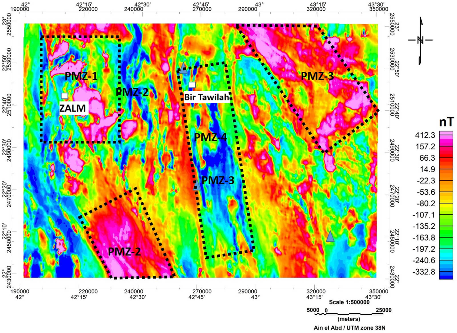
Proposed localities (labeled by PMZ-1, PMZ-2, PMZ-3, and PMZ-4) for future gold mineralization exploration in the study area.
5 Conclusion
The Zalm district, located in western Saudi Arabia, is in high demand for additional research due to its notable gold potential and the presence of abandoned gold mine workings. The gold deposit in the Zalm district is an example of Pan-African gold mineralization. Magnetic mapping of the lithology and structural faulting in the district was conducted using enhancement techniques, namely, RTP, 1VD, and AS, to identify probable gold mineralization zones. According to interpretations of the aeromagnetic maps, the primary structural faulting systems affecting the Zalm district are the NW, NE, and NS faulting systems. Based on the pattern and intensity of the magnetic anomalies in the region, the maps show two distinct magnetic anomalies. The NS trending fault zone and areas of low magnetic anomalies, which indicate the dominance of felsic diorite, granodiorite, and granite intrusions, constitute the “Nabitah orogenic zone.” High magnetic anomalies are associated with the gabbro-granite and ultramafic intrusions in the Nabitah suture zone which formed during terrane amalgamation. Massive intrusions of felsic diorite, granodiorite, and granite, as well as mafic-ultramafic intrusions, are thought to be the sources of the host mineralization. Conversely these felsic and mafic intrusions are likely the source of the mineralizing fluids that moved through the NW and NS faults, acting as crucial conduits for the hydrothermal fluids that generally led to ore remobilization in the region. It is hypothesized that the heat from these hydrothermal fluids triggered convection of meteoric water facilitating the leaching of gold from the surrounding rocks [8].
Acknowledgements
This research was supported by Researchers supporting Project number (RSP2025R425), King Saud University, Riyadh, Saudi Arabia.
-
Author contributions: Hassan Alzahrani contributed to the conception of the manuscript and revised it. Elkhedr Ibrahim contributed importantly to the analysis, review, and editing. Two authors have read and agreed to the published version of the manuscript.
-
Conflict of interest: All authors declare that there is no conflict of interest.
References
[1] Agar R. Geologic map of the Zalm quadrangle, sheet 22F, Kingdom of Saudi Arabia. Saudi Arabian Deputy Ministry for Mineral Resources Geologic Map GM 89 (scale 1:250,000); 1988.Search in Google Scholar
[2] Bounny I. Mineral exploration in the Halaban formation, AlMuwayh and Zalim areas, and completion report. French Bureau de Recherches Geologiques et Minieres Open-File Report (77-JED-21); 1977.Search in Google Scholar
[3] Colliver I, Fuchter W. Investigations of gold potential in the As-Siham district. Saudi Arabian Deputy Ministry for Mineral Resources Open-File Report (RF-OF-01-2); 1981.Search in Google Scholar
[4] Crop J, Elsass P. Sampling of the ancient gold working in the Jabal As Siham-As Suq area. Saudi Arabian Deputy Ministry for Mineral Resources Open-File Report (BRGM-OF-01-20); 1981.Search in Google Scholar
[5] Gaukroger K, Morfett E. Exploration for gold in the Zalm-As Siham district. Saudi Arabian Deputy Ministry for Mineral Resources Open-File Report (RF-OF-02-30); 1983.Search in Google Scholar
[6] Sahl M. Reconnaissance geology of the Zalm quadrangle, sheet22/42B, Kingdom of Saudi Arabia: Saudi Arabian Deputy Ministry for Mineral Resources Open-File Report (DGMR-OF-04-17); 1989.Search in Google Scholar
[7] Surour A, Ahmed A, Harbi H. Yukonite-like alteration products (Ca–Fe arsenate and As-rich oxyhydroxide) formed by in situ weathering in granodiorite, Bi'r Tawilah gold prospect, Saudi Arabia. Eur J Min. 2013;25:61–70.10.1127/0935-1221/2013/0025-2246Search in Google Scholar
[8] Surour A, Harbi H, Ahmed A. The Bi'r Tawilah deposit, central western Saudi Arabia: Supergene enrichment of a Pan-African epithermal gold mineralization. J Afr Earth Sci. 2014;89:149–63.10.1016/j.jafrearsci.2013.06.007Search in Google Scholar
[9] Gabr S, Diab H, Abdel Fattah Th, Sadek M, Khalil Kh, Youssef M. Aeromagnetic and Landsat-8 data interpretation for structural and hydrothermal alteration mapping along the Central and Southern Eastern Desert boundary, Egypt. Egypt J Remote Sens Space Sci. 2022;25:11–20.10.1016/j.ejrs.2021.12.002Search in Google Scholar
[10] ElGalladi A, Araffa S, Mekkawi M, Abd-AlHai M. Exploring mineralization zones using remote sensing and aeromagnetic data, West Allaqi Area, Eastern-Desert, Egypt. Egypt J Remote Sens Space Sci. 2022;25:417–33.10.1016/j.ejrs.2022.03.007Search in Google Scholar
[11] Eldosouky A. Aeromagnetic data for mapping geologic contacts at Samr El-Qaa area, North Eastern Desert, Egypt. Arab J Geosci. 2019;12:2. 10.1007/s12517-018-4182-2.Search in Google Scholar
[12] Elkhateeb S, Eldosouky A. Detection of porphyry intrusions using analytic signal (AS), Euler Deconvolution, and Center for Exploration Targeting (CET) Technique Porphyry Analysis at Wadi Allaqi Area, South Eastern Desert Egypt. Int J Sci Eng Res. 2016;7(6):471–7.Search in Google Scholar
[13] Gobashy M, Mekkawi M, Arfaffa S, Ezz Eldin M, Khalil M. Magnetic signature of gold deposits: Example from Um Garayat Region, South Eastern Desert, Egypt. Pure Appl Geophys. 2023;180:1053–80. 10.1007/s00024-023-03228-8.Search in Google Scholar
[14] Eldougdoug A, Abdelazeem M, Gobashy M, Abdelwahed M, Abd El‑Rahman Y, Abdelhalim A, et al. Exploring gold mineralization in altered ultramafic rocks in south Abu Marawat, Eastern Desert, Egypt. Sci Rep. 2023;13:7293. 10.1038/s41598-023-33947-www.nature.com/scientificreports.10.1038/s41598-023-33947-wSearch in Google Scholar PubMed PubMed Central
[15] Nehlig P, Antonin G, Asfirane F, Guerrot C, Eberlé J, Kluyver H, et al. A review of the Pan-African evolution of the Arabian shield. GeoArabia. 2002;7(1):103–23. 10.2113/geoarabia0701103.Search in Google Scholar
[16] Johnson P. Post-amalgamation basins of the NE Arabian shield and implications for Neoproterozoic tectonism in the northern East African orogeny. Precambrian Res. 2003;123:321–37.10.1016/S0301-9268(03)00074-3Search in Google Scholar
[17] Johnson P, Andresen A, Collins A, Fowler A, Fritz H, Ghebreab W, et al. Late Cryogenian–Ediacaran history of the Arabian–Nubian Shield: A review of depositional, plutonic, structural, and tectonic events in the closing stages of the northern East African Orogen. J Afr Earth Sci. 2011;61:167–232.10.1016/j.jafrearsci.2011.07.003Search in Google Scholar
[18] Johnson P, Vranas G. The origin and the development of late Proterozoic rocks of the Arabian shield: An analysis of terranes and mineral environments. Saudi Arabian Deputy Ministry for Mineral Resources, Open-File-Report, RF-OF-04-32; 1984. p. 96.Search in Google Scholar
[19] Stoeser D, Camp V. Pan-African microplate accretion of the Arabian Shield. Geol Soc Am Bull. 1985;96:817–26.10.1130/0016-7606(1985)96<817:PMAOTA>2.0.CO;2Search in Google Scholar
[20] Johnson P. Tectonic development of the Arabian shield: An overview. U.S. Geological Survey Saudi Arabia Mission, IUGS/UNESCO Deposit Modelling Workshop, Jeddah, Saudi Arabia; 1999.Search in Google Scholar
[21] Doebrich J, Zahony S, Leavitt J, Portacio Jr J, Siddiqui A, Wooden J, et al. Ad Duwayhi, Saudi Arabia: Geology and geochronology of a Neoproterozoic intrusion-related gold system in the Arabian Shield. Econ Geol. 2004;99:713–41.10.2113/gsecongeo.99.4.713Search in Google Scholar
[22] Labbe J. A preliminary survey of the Bi'r Tawilah Gold and Tungsten–Tin prospect. French Bureau de Recherches Geologiques et Minieres Open-File, Report, BRGM-OF-04-21; 1984.Search in Google Scholar
[23] Billa M. Exploration of the Jabal Ghadarah gold deposit, Bir Tawilah District. Saudi Arabian Deputy Ministry for Mineral Resources Open-File Report BRGMOF-06-15; 1987. p. 46.Search in Google Scholar
[24] Couturier P. Geology and evaluation of the mining potential of the Bir Tawilah main gold prospect. Saudi Arabian Deputy Ministry for Mineral Resources Open File, Report, BRGM-OF-06-21; 1988.Search in Google Scholar
[25] Harbi H, Eldougdoug A, Al Jahdali N. Evolution of the Arabian shield and associated mineralization. In The 9th Arab Conf. of Mineral Resources, Kingdom of Saudi Arabia, Jeddah, 30 October–1 November; 2006. p. 1–11.Search in Google Scholar
[26] Fleck R, Coleman R, Cornwall H, Greenwood W, Hadley D, Prinz W, et al. Potassium-argon geochronology of the Arabian shield, Kingdom of Saudi Arabia. Geol Soc Am Bull. 1976;87:9–21.10.1130/0016-7606(1976)87<9:GOTASW>2.0.CO;2Search in Google Scholar
[27] Dube B, Gosselin P, Mercier-Langevin P, Hannington M, Galley A. Goldrich volcanogenic massive sulphide deposits. In: Goodfellow WD, ed. Mineral deposits of Canada: A synthesis of major deposit-types, district metallogeny, the evolution of geological provinces, and exploration methods. Geological association of Canada, mineral deposits division, Special Publication No. 5; 2007. p. 75–94.Search in Google Scholar
[28] Mercier-Langevin P, Hannington M, Dube B, Becu V. The gold content of volcanogenic massive sulphide deposits. Mineralium Deposita. 2010;46:509–39.10.1007/s00126-010-0300-0Search in Google Scholar
[29] Collenette P, Grainger D. Mineral resources of Saudi Arabia, not including oil, natural gas, and sulfur. Ministry of Petroleum and Mineral Resources, Directorate General of Mineral Resources, Jeddah, Kingdom of Saudi Arabia; 1994. p. 322.Search in Google Scholar
[30] Nehlig P, Salpeteur I, Asfirane F, Bouchot V, Eberle J, Genna A, et al. The Arabian shield project participants, 1999. The mineral potential of the Arabian shield: A re-assessment. UGS/UNESCO Meeting on the Base and Precious Metal Deposits in the Arabian Shield held in Jeddah; 1999. p. 12–9.Search in Google Scholar
[31] Leistel J, Al Jahdli N, Khalil I, Kattu G, Eberle J, Lembert A, et al. Results of precious metal exploration in the Zalim prospect, Kingdom of Saudi Arabia. Saudi Arabian Deputy Ministry for Mineral Resources Technical Report, BRGM-TR-99-14; 1999. p. 108.Search in Google Scholar
[32] Al Jahdli N. Geology of Jabal Ghadarah area, Bi'r Tawilah district with special emphasis on listvenite as a potential source for gold in the Kingdom of Saudi Arabia. M.Sc. thesis. Jeddah, Saudi Arabia: King Abdulaziz University; 2004.Search in Google Scholar
[33] Agar R, Stacey J, Whitehouse M. Evolution of the southern Afif terrane - a geochronological study. Open-File Report DMMR-OF-10-15. Saudi Arabian Directorate General of Mineral Resources; 1992.Search in Google Scholar
[34] Al Shanti A. Geology of the Arabian shield. Scientific Publication Center, King Abdulaziz University, Jeddah, Saudi Arabia; 1993. p. 196 (in Arabic).Search in Google Scholar
[35] Kahal A, Abd El-Motaal E, Kassem O, Al Ghoreiby A. Strain analysis and deformation history of Zalm district, Arabian shield, Saudi Arabia. J Afr Earth Sci. 2019;150:441–50.10.1016/j.jafrearsci.2018.09.008Search in Google Scholar
[36] Cole J, Hedge C. Geochronologic investigation of Late Proterozoic rocks in the northeastern Shield of Saudi Arabia. Saudi Arabian Deputy Ministry for Mineral Resources Technical Record USGS-TR-05-5; 1986. p. 42.Search in Google Scholar
[37] Matsah M, Kusky T. Analysis of Landsat ratio imagery of the Halaban–Zarghat fault and related Jifn basin, NE Arabian shield: Implications for the kinematic history of the Najd fault. Gondwana Res. 2001;4:182.10.1016/S1342-937X(05)70686-9Search in Google Scholar
[38] Kusky T, Matsah M. Neoproterozoic dextral faulting on the Najd Fault System, Saudi Arabia, preceded sinistral faulting and escape tectonics related to closure of the Mozambique Ocean. In: Yoshida M, Windley BF, Dasgupta S, Powell C, editors. Proterozoic East Gondwana: Supercontinent assembly and breakup. Geological Society, London, Special Publication. Vol. 206, 2003. p. 327–61.10.1144/GSL.SP.2003.206.01.16Search in Google Scholar
[39] Nehlig P, Asfirane F, Genna A, Guerrot C, Nicol N, Salpeteur I, et al. Aeromagnetic map constrains cratonization of the Arabian Shield. Terra Nova. 2001;13(5):347–53.10.1046/j.1365-3121.2001.00370.xSearch in Google Scholar
[40] Blank H, Andreasen G. Compilation and interpretation of aero-magnetic data for the Precambrian Arabian Shield, Kingdom of Saudi Arabia. Open File Report USGS-OF-10-8. Saudi Arabian Directorate General of Mineral Resources; 1991.Search in Google Scholar
[41] Zahran H, Stewart I, Johnson P, Basahel M. Aeromagnetic-anomaly maps of central and western Saudi Arabia. Saudi Geological Survey Open-File Report SGS-OF-2002-8, 6 pp, 1 fig, 1 table, 4 sheets (scale 1:2,000,000); 2003.Search in Google Scholar
[42] Geosoft program (Oasis Montaj, 8.3.3). Processing and analysis of geophysical data. Canada: Geosoft Corporation; 2015.Search in Google Scholar
[43] Nabighian M. Toward a three-dimensional automatic interpretation of potential field data via generalized Hilbert transforms: Fundamental relations. Geophysics. 1984;49(6):780–6.10.1190/1.1441706Search in Google Scholar
[44] Smith J. Analytic signals and Hilbert transform filters. In Mathematics of the discrete fourier transform (DFT) with audio applications. 2nd edn. online book, 2007 edition, accessed 2021-04-29; 2021.Search in Google Scholar
[45] Ansari A, Alamdar K. Reduction to the pole of magnetic anomalies using analytic signal. World Appl Sci J. 2009;7:405–9.Search in Google Scholar
[46] Roest W, Verhoef J, Pilkington M. Magnetic interpretation using 3-D analytic signal. Geophysics. 1992;57:116–25.10.1190/1.1443174Search in Google Scholar
[47] Briggs IC. Machine contouring using minimum curvature. Geophysics. 1974;39(1):39–48. 10.1190/1.1440410.Search in Google Scholar
[48] Swain CJ. A FORTRAN IV program for interpolating irregularly spaced data using the difference equations for minimum curvature. Computers Geosci. 1976;1(4):231–40. 10.1016/0098-3004 (76)90071-6.Search in Google Scholar
[49] Telford W, Geldart L, Sheriff R. Applied geophysics. Cambridge: Cambridge University Press; 1990.10.1017/CBO9781139167932Search in Google Scholar
[50] Surour A, El-Bayoumi R, Attawiya M, El-Feky M. Geochemistry of wall rock alterations and radioactive mineralization in the vicinity of Hangaliya uraniferous shear zone, Eastern Desert, Egypt. Egypt J Geol. 2001;45:187–212.Search in Google Scholar
[51] Kusky T, Ramadan T. Structural controls on Neoproterozoic mineralization in the South Eastern Desert, Egypt: an integrated field, Landsat TM and SIR-C/X SAR approach. J Afr Earth Sci. 2002;35:107–21.10.1016/S0899-5362(02)00029-5Search in Google Scholar
[52] Zoheir B. Structural controls, temperature–pressure conditions and fluid evolution of orogenic gold mineralisation in Egypt: a case study from the Betam gold mine, south Eastern Desert. Mineralium Deposita. 2008;43:79–95.10.1007/s00126-007-0156-0Search in Google Scholar
[53] Zoheir B. Transpressional zones in ophiolitic melange terranes: Potential exploration targets for gold in the South Eastern Desert, Egypt. J Geochem Explor. 2011;111:23–38.10.1016/j.gexplo.2011.07.003Search in Google Scholar
[54] Gabr S, Ghulam A, Kusky T. Detecting areas of high-potential gold mineralization using ASTER data. Ore Geol Rev. 2010;38:59–69.10.1016/j.oregeorev.2010.05.007Search in Google Scholar
[55] Sahl M, Al-Shanti A, Tawfiq M. Evolution of mineral exploration in the Kingdom of Saudi Arabia during a hundred of years. Ministry of Petroleum and Mineral, Resources, KSA; 1999 (in Arabic).Search in Google Scholar
[56] Moore J. Tectonics of the Najd transcurrent fault system, Saudi Arabia. Geol Soc Lond. 1979;136:441–54.10.1144/gsjgs.136.4.0441Search in Google Scholar
[57] Stacey J, Agar R. U–Pb isotopic evidence for the accretion of a continental microplate in the Zalm region of the Saudi Arabian shield. J Geol Soc Lond. 1985;142:1189–203.10.1144/gsjgs.142.6.1189Search in Google Scholar
© 2025 the author(s), published by De Gruyter
This work is licensed under the Creative Commons Attribution 4.0 International License.
Articles in the same Issue
- Research Articles
- Seismic response and damage model analysis of rocky slopes with weak interlayers
- Multi-scenario simulation and eco-environmental effect analysis of “Production–Living–Ecological space” based on PLUS model: A case study of Anyang City
- Remote sensing estimation of chlorophyll content in rape leaves in Weibei dryland region of China
- GIS-based frequency ratio and Shannon entropy modeling for landslide susceptibility mapping: A case study in Kundah Taluk, Nilgiris District, India
- Natural gas origin and accumulation of the Changxing–Feixianguan Formation in the Puguang area, China
- Spatial variations of shear-wave velocity anomaly derived from Love wave ambient noise seismic tomography along Lembang Fault (West Java, Indonesia)
- Evaluation of cumulative rainfall and rainfall event–duration threshold based on triggering and non-triggering rainfalls: Northern Thailand case
- Pixel and region-oriented classification of Sentinel-2 imagery to assess LULC dynamics and their climate impact in Nowshera, Pakistan
- The use of radar-optical remote sensing data and geographic information system–analytical hierarchy process–multicriteria decision analysis techniques for revealing groundwater recharge prospective zones in arid-semi arid lands
- Effect of pore throats on the reservoir quality of tight sandstone: A case study of the Yanchang Formation in the Zhidan area, Ordos Basin
- Hydroelectric simulation of the phreatic water response of mining cracked soil based on microbial solidification
- Spatial-temporal evolution of habitat quality in tropical monsoon climate region based on “pattern–process–quality” – a case study of Cambodia
- Early Permian to Middle Triassic Formation petroleum potentials of Sydney Basin, Australia: A geochemical analysis
- Micro-mechanism analysis of Zhongchuan loess liquefaction disaster induced by Jishishan M6.2 earthquake in 2023
- Prediction method of S-wave velocities in tight sandstone reservoirs – a case study of CO2 geological storage area in Ordos Basin
- Ecological restoration in valley area of semiarid region damaged by shallow buried coal seam mining
- Hydrocarbon-generating characteristics of Xujiahe coal-bearing source rocks in the continuous sedimentary environment of the Southwest Sichuan
- Hazard analysis of future surface displacements on active faults based on the recurrence interval of strong earthquakes
- Structural characterization of the Zalm district, West Saudi Arabia, using aeromagnetic data: An approach for gold mineral exploration
- Research on the variation in the Shields curve of silt initiation
- Reuse of agricultural drainage water and wastewater for crop irrigation in southeastern Algeria
- Assessing the effectiveness of utilizing low-cost inertial measurement unit sensors for producing as-built plans
- Analysis of the formation process of a natural fertilizer in the loess area
- Machine learning methods for landslide mapping studies: A comparative study of SVM and RF algorithms in the Oued Aoulai watershed (Morocco)
- Chemical dissolution and the source of salt efflorescence in weathering of sandstone cultural relics
- Molecular simulation of methane adsorption capacity in transitional shale – a case study of Longtan Formation shale in Southern Sichuan Basin, SW China
- Evolution characteristics of extreme maximum temperature events in Central China and adaptation strategies under different future warming scenarios
- Estimating Bowen ratio in local environment based on satellite imagery
- 3D fusion modeling of multi-scale geological structures based on subdivision-NURBS surfaces and stratigraphic sequence formalization
- Comparative analysis of machine learning algorithms in Google Earth Engine for urban land use dynamics in rapidly urbanizing South Asian cities
- Study on the mechanism of plant root influence on soil properties in expansive soil areas
- Simulation of seismic hazard parameters and earthquakes source mechanisms along the Red Sea rift, western Saudi Arabia
- Tectonics vs sedimentation in foredeep basins: A tale from the Oligo-Miocene Monte Falterona Formation (Northern Apennines, Italy)
- Investigation of landslide areas in Tokat-Almus road between Bakımlı-Almus by the PS-InSAR method (Türkiye)
- Predicting coastal variations in non-storm conditions with machine learning
- Cross-dimensional adaptivity research on a 3D earth observation data cube model
- Geochronology and geochemistry of late Paleozoic volcanic rocks in eastern Inner Mongolia and their geological significance
- Spatial and temporal evolution of land use and habitat quality in arid regions – a case of Northwest China
- Ground-penetrating radar imaging of subsurface karst features controlling water leakage across Wadi Namar dam, south Riyadh, Saudi Arabia
- Rayleigh wave dispersion inversion via modified sine cosine algorithm: Application to Hangzhou, China passive surface wave data
- Fractal insights into permeability control by pore structure in tight sandstone reservoirs, Heshui area, Ordos Basin
- Debris flow hazard characteristic and mitigation in Yusitong Gully, Hengduan Mountainous Region
- Research on community characteristics of vegetation restoration in hilly power engineering based on multi temporal remote sensing technology
- Identification of radial drainage networks based on topographic and geometric features
- Trace elements and melt inclusion in zircon within the Qunji porphyry Cu deposit: Application to the metallogenic potential of the reduced magma-hydrothermal system
- Pore, fracture characteristics and diagenetic evolution of medium-maturity marine shales from the Silurian Longmaxi Formation, NE Sichuan Basin, China
- Study of the earthquakes source parameters, site response, and path attenuation using P and S-waves spectral inversion, Aswan region, south Egypt
- Source of contamination and assessment of potential health risks of potentially toxic metal(loid)s in agricultural soil from Al Lith, Saudi Arabia
- Regional spatiotemporal evolution and influencing factors of rural construction areas in the Nanxi River Basin via GIS
- An efficient network for object detection in scale-imbalanced remote sensing images
- Effect of microscopic pore–throat structure heterogeneity on waterflooding seepage characteristics of tight sandstone reservoirs
- Environmental health risk assessment of Zn, Cd, Pb, Fe, and Co in coastal sediments of the southeastern Gulf of Aqaba
- A modified Hoek–Brown model considering softening effects and its applications
- Evaluation of engineering properties of soil for sustainable urban development
- The spatio-temporal characteristics and influencing factors of sustainable development in China’s provincial areas
- Application of a mixed additive and multiplicative random error model to generate DTM products from LiDAR data
- Gold vein mineralogy and oxygen isotopes of Wadi Abu Khusheiba, Jordan
- Prediction of surface deformation time series in closed mines based on LSTM and optimization algorithms
- 2D–3D Geological features collaborative identification of surrounding rock structural planes in hydraulic adit based on OC-AINet
- Spatiotemporal patterns and drivers of Chl-a in Chinese lakes between 1986 and 2023
- Land use classification through fusion of remote sensing images and multi-source data
- Nexus between renewable energy, technological innovation, and carbon dioxide emissions in Saudi Arabia
- Analysis of the spillover effects of green organic transformation on sustainable development in ethnic regions’ agriculture and animal husbandry
- Factors impacting spatial distribution of black and odorous water bodies in Hebei
- Large-scale shaking table tests on the liquefaction and deformation responses of an ultra-deep overburden
- Impacts of climate change and sea-level rise on the coastal geological environment of Quang Nam province, Vietnam
- Reservoir characterization and exploration potential of shale reservoir near denudation area: A case study of Ordovician–Silurian marine shale, China
- Seismic prediction of Permian volcanic rock reservoirs in Southwest Sichuan Basin
- Application of CBERS-04 IRS data to land surface temperature inversion: A case study based on Minqin arid area
- Geological characteristics and prospecting direction of Sanjiaoding gold mine in Saishiteng area
- Research on the deformation prediction model of surrounding rock based on SSA-VMD-GRU
- Geochronology, geochemical characteristics, and tectonic significance of the granites, Menghewula, Southern Great Xing’an range
- Hazard classification of active faults in Yunnan base on probabilistic seismic hazard assessment
- Characteristics analysis of hydrate reservoirs with different geological structures developed by vertical well depressurization
- Estimating the travel distance of channelized rock avalanches using genetic programming method
- Landscape preferences of hikers in Three Parallel Rivers Region and its adjacent regions by content analysis of user-generated photography
- New age constraints of the LGM onset in the Bohemian Forest – Central Europe
- Characteristics of geological evolution based on the multifractal singularity theory: A case study of Heyu granite and Mesozoic tectonics
- Soil water content and longitudinal microbiota distribution in disturbed areas of tower foundations of power transmission and transformation projects
- Oil accumulation process of the Kongdian reservoir in the deep subsag zone of the Cangdong Sag, Bohai Bay Basin, China
- Investigation of velocity profile in rock–ice avalanche by particle image velocimetry measurement
- Optimizing 3D seismic survey geometries using ray tracing and illumination modeling: A case study from Penobscot field
- Sedimentology of the Phra That and Pha Daeng Formations: A preliminary evaluation of geological CO2 storage potential in the Lampang Basin, Thailand
- Improved classification algorithm for hyperspectral remote sensing images based on the hybrid spectral network model
- Map analysis of soil erodibility rates and gully erosion sites in Anambra State, South Eastern Nigeria
- Identification and driving mechanism of land use conflict in China’s South-North transition zone: A case study of Huaihe River Basin
- Evaluation of the impact of land-use change on earthquake risk distribution in different periods: An empirical analysis from Sichuan Province
- A test site case study on the long-term behavior of geotextile tubes
- An experimental investigation into carbon dioxide flooding and rock dissolution in low-permeability reservoirs of the South China Sea
- Detection and semi-quantitative analysis of naphthenic acids in coal and gangue from mining areas in China
- Comparative effects of olivine and sand on KOH-treated clayey soil
- YOLO-MC: An algorithm for early forest fire recognition based on drone image
- Earthquake building damage classification based on full suite of Sentinel-1 features
- Potential landslide detection and influencing factors analysis in the upper Yellow River based on SBAS-InSAR technology
- Assessing green area changes in Najran City, Saudi Arabia (2013–2022) using hybrid deep learning techniques
- An advanced approach integrating methods to estimate hydraulic conductivity of different soil types supported by a machine learning model
- Hybrid methods for land use and land cover classification using remote sensing and combined spectral feature extraction: A case study of Najran City, KSA
- Streamlining digital elevation model construction from historical aerial photographs: The impact of reference elevation data on spatial accuracy
- Analysis of urban expansion patterns in the Yangtze River Delta based on the fusion impervious surfaces dataset
- A metaverse-based visual analysis approach for 3D reservoir models
- Late Quaternary record of 100 ka depositional cycles on the Larache shelf (NW Morocco)
- Integrated well-seismic analysis of sedimentary facies distribution: A case study from the Mesoproterozoic, Ordos Basin, China
- Study on the spatial equilibrium of cultural and tourism resources in Macao, China
- Urban road surface condition detecting and integrating based on the mobile sensing framework with multi-modal sensors
- Application of improved sine cosine algorithm with chaotic mapping and novel updating methods for joint inversion of resistivity and surface wave data
- The synergistic use of AHP and GIS to assess factors driving forest fire potential in a peat swamp forest in Thailand
- Dynamic response analysis and comprehensive evaluation of cement-improved aeolian sand roadbed
- Rock control on evolution of Khorat Cuesta, Khorat UNESCO Geopark, Northeastern Thailand
- Gradient response mechanism of carbon storage: Spatiotemporal analysis of economic-ecological dimensions based on hybrid machine learning
- Comparison of several seismic active earth pressure calculation methods for retaining structures
- Mantle dynamics and petrogenesis of Gomer basalts in the Northwestern Ethiopia: A geochemical perspective
- Study on ground deformation monitoring in Xiong’an New Area from 2021 to 2023 based on DS-InSAR
- Paleoenvironmental characteristics of continental shale and its significance to organic matter enrichment: Taking the fifth member of Xujiahe Formation in Tianfu area of Sichuan Basin as an example
- Equipping the integral approach with generalized least squares to reconstruct relict channel profile and its usage in the Shanxi Rift, northern China
- InSAR-driven landslide hazard assessment along highways in hilly regions: A case-based validation approach
- Attribution analysis of multi-temporal scale surface streamflow changes in the Ganjiang River based on a multi-temporal Budyko framework
- Maps analysis of Najran City, Saudi Arabia to enhance agricultural development using hybrid system of ANN and multi-CNN models
- Hybrid deep learning with a random forest system for sustainable agricultural land cover classification using DEM in Najran, Saudi Arabia
- Long-term evolution patterns of groundwater depth and lagged response to precipitation in a complex aquifer system: Insights from Huaibei Region, China
- Remote sensing and machine learning for lithology and mineral detection in NW, Pakistan
- Spatial–temporal variations of NO2 pollution in Shandong Province based on Sentinel-5P satellite data and influencing factors
- Numerical modeling of geothermal energy piles with sensitivity and parameter variation analysis of a case study
- Stability analysis of valley-type upstream tailings dams using a 3D model
- Variation characteristics and attribution analysis of actual evaporation at monthly time scale from 1982 to 2019 in Jialing River Basin, China
- Investigating machine learning and statistical approaches for landslide susceptibility mapping in Minfeng County, Xinjiang
- Investigating spatiotemporal patterns for comprehensive accessibility of service facilities by location-based service data in Nanjing (2016–2022)
- A pre-treatment method for particle size analysis of fine-grained sedimentary rocks, Bohai Bay Basin, China
- Study on the formation mechanism of the hard-shell layer of liquefied silty soil
- Comprehensive analysis of agricultural CEE: Efficiency assessment, mechanism identification, and policy response – A case study of Anhui Province
- Simulation study on the damage and failure mechanism of the surrounding rock in sanded dolomite tunnels
- Towards carbon neutrality: Spatiotemporal evolution and key influences on agricultural ecological efficiency in Northwest China
- High-frequency cycles drive the cyclical enrichment of oil in porous carbonate reservoirs: A case study of the Khasib Formation in E Oilfield, Mesopotamian Basin, Iraq
- Reconstruction of digital core models of granular rocks using mathematical morphology
- Spatial–temporal differentiation law of habitat quality and its driving mechanism in the typical plateau areas of the Loess Plateau in the recent 30 years
- A machine-learning-based approach to predict potential oil sites: Conceptual framework and experimental evaluation
- Effects of landscape pattern change on waterbird diversity in Xianghai Nature Reserve
- Research on intelligent classification method of highway tunnel surrounding rock classification based on parameters while drilling
- River morphology and tectono-sedimentary analysis of a shallow river delta: A case study of Putaohua oil layer in Saertu oilfield (L. Cretaceous), China
- Review Articles
- Humic substances influence on the distribution of dissolved iron in seawater: A review of electrochemical methods and other techniques
- Applications of physics-informed neural networks in geosciences: From basic seismology to comprehensive environmental studies
- Ore-controlling structures of granite-related uranium deposits in South China: A review
- Shallow geological structure features in Balikpapan Bay East Kalimantan Province – Indonesia
- A review on the tectonic affinity of microcontinents and evolution of the Proto-Tethys Ocean in Northeastern Tibet
- Advancements in machine learning applications for mineral prospecting and geophysical inversion: A review
- Special Issue: Natural Resources and Environmental Risks: Towards a Sustainable Future - Part II
- Depopulation in the Visok micro-region: Toward demographic and economic revitalization
- Special Issue: Geospatial and Environmental Dynamics - Part II
- Advancing urban sustainability: Applying GIS technologies to assess SDG indicators – a case study of Podgorica (Montenegro)
- Spatiotemporal and trend analysis of common cancers in men in Central Serbia (1999–2021)
- Minerals for the green agenda, implications, stalemates, and alternatives
- Spatiotemporal water quality analysis of Vrana Lake, Croatia
- Functional transformation of settlements in coal exploitation zones: A case study of the municipality of Stanari in Republic of Srpska (Bosnia and Herzegovina)
- Hypertension in AP Vojvodina (Northern Serbia): A spatio-temporal analysis of patients at the Institute for Cardiovascular Diseases of Vojvodina
- Regional patterns in cause-specific mortality in Montenegro, 1991–2019
- Spatio-temporal analysis of flood events using GIS and remote sensing-based approach in the Ukrina River Basin, Bosnia and Herzegovina
- Flash flood susceptibility mapping using LiDAR-Derived DEM and machine learning algorithms: Ljuboviđa case study, Serbia
- Geocultural heritage as a basis for geotourism development: Banjska Monastery, Zvečan (Serbia)
- Assessment of groundwater potential zones using GIS and AHP techniques – A case study of the zone of influence of Kolubara Mining Basin
- Impact of the agri-geographical transformation of rural settlements on the geospatial dynamics of soil erosion intensity in municipalities of Central Serbia
- Where faith meets geomorphology: The cultural and religious significance of geodiversity explored through geospatial technologies
- Applications of local climate zone classification in European cities: A review of in situ and mobile monitoring methods in urban climate studies
- Complex multivariate water quality impact assessment on Krivaja River
- Ionization hotspots near waterfalls in Eastern Serbia’s Stara Planina Mountain
- Shift in landscape use strategies during the transition from the Bronze age to Iron age in Northwest Serbia
- Assessing the geotourism potential of glacial lakes in Plav, Montenegro: A multi-criteria assessment by using the M-GAM model
- Flash flood potential index at national scale: Susceptibility assessment within catchments
- SWAT modelling and MCDM for spatial valuation in small hydropower planning
- Disaster risk perception and local resilience near the “Duboko” landfill: Challenges of governance, management, trust, and environmental communication in Serbia