Impact of the agri-geographical transformation of rural settlements on the geospatial dynamics of soil erosion intensity in municipalities of Central Serbia
-
Tanja Srejić
 ,
Sanja Manojlović
,
Sanja Manojlović

Abstract
The aim of study is to analyze the agri-geographical transformation of rural settlements on changes in the intensity of soil erosion and the geospatial differentiation of soil erosion intensity according to the specificities of rural settlements. The study area included 349 rural settlements in 14 municipalities of Central Serbia. The shift-share analysis method was applied to identify four types of rural settlements: progressive, stagnant, regressive, and dominantly regressive types. An erosion potential model was used to estimate the soil erosion in 1971 and 2011. Cluster analysis (CA) was used to differentiate rural areas of municipalities based on selected indicators. The highest rates of soil erosion intensity reduction were found in the regressive and dominantly regressive types (average specific gross erosion 1971: Ws1 = 980 m3/km2/year; 2011: Ws2 = 587 m3/km2/year). The lowest reduction in erosion intensity was observed in the progressive and stagnant types (average specific gross erosion in 1971: Ws1 = 1,214 m3/km2/year; 2011: Ws2 = 936 m3/km2/year). The spatial differentiation of municipalities through CA revealed a clear pattern: the risk of soil erosion decreases along a north-south gradient. Also, the results of CA showed that natural conditions (forest cover, mean altitude, sediments of Neogene) are the most significant in the differentiation of the rural space of Central Serbia. The multidisciplinary approach used in this study enables a holistic understanding of erosion processes, supports the identification of spatial patterns, and facilitates the formulation of targeted and region-specific land management strategies.
1 Introduction
Spatial patterns of land use are highly complex and heterogeneous [1], and changes in land use over time are not a linear process, but rather manifest in waves or cycles [2]. Studies have shown that the period from 1960 to 2005 was characterized as a phase of global acceleration, followed by the period from 2006 to 2019, which was marked as a phase of global deceleration [3]. Recent research results indicate that land use change has affected one-third of the global terrestrial surface over the past six decades [3]. Land use changes in accordance with the evolution of multiple simultaneous and interconnected factors [4]. Economic (changes in global and local markets, incentives for rural development, subsidy policies), technological (modernization of equipment and biotechnological innovations), political (legislative regulations, political approaches), ecological (climate change, biodiversity, and the protection of natural resources), and demographic factors (migration, urbanization, population aging) are the primary drivers of land use change [1,4,5,6]. These changes may result from long-term trends (e.g., population aging and climate change) or short-term decisions (e.g., subsidies or price fluctuations on the market) [5].
Data on the extent, patterns, and trends of land use are crucial for supporting global and national priorities and for sustainable development [7]. Some regions are more stable in terms of land use, while others experience rapid changes caused by urbanization, mining, and the intensification of agriculture [8,9]. In certain parts of the world, an increase in agricultural land has been recorded [6,9]. Sub-Saharan Africa is the region with the highest human pressures on agricultural land [10]. On the other hand, there are regions that have been marked for decades by the abandonment of agricultural land and the spontaneous expansion of forested areas [11,12,13,14,15,16,17]. The phenomena of abandonment and expansion of agricultural land are not opposite aspects of the same process, as the factors influencing them may differ [18].
Nevertheless, the global dynamics of agricultural land are moving toward the optimization of land use, with a tendency toward increasing the efficiency of production on existing land [19,20,21]. This means that for agricultural production, increasing productivity and intensifying agricultural practices are key, rather than expanding agricultural areas [22].
The role of agriculture in the context of soil erosion is becoming increasingly significant, due to growing challenges in sustainable development and environmental protection. The geomorphological response to land use change is nonlinear: a small change in the percentage of arable land leads to relatively large changes in erosion risk and sediment transport [23].
On a global scale, human activities such as deforestation, intensive agriculture, and urban expansion have drastically altered natural sediment dynamics, making anthropogenic erosion a dominant process of land degradation in the Anthropocene [24]. One of the key reasons for unsustainable land management is the rapid population growth. This generates intense agrarian pressure due to the increasing demand for food [25,26]. This is particularly evident in developing countries, where the survival of millions of people depends on the functional capacity of land resources [27]. The greatest soil losses caused by erosion in East African countries originate from the Ethiopian Highlands [28]. Numerous studies confirm that unsustainable agricultural practices, rapid population growth [29,30], and the absence of effective land management policies [31] are the primary causes of land degradation in Ethiopia, resulting in extensive soil erosion and deepening rural poverty [32]. Wang et al. (2018) found that urbanization in the Inner Mongolia region increases soil erosion by 15–25%, and that intensive land use changes lead to permanent land degradation [33]. The reduction in forest cover directly affects soil properties (reduction in organic carbon, decreased biological activity, loss of fertility, etc.), thereby accelerating the process of erosion worldwide. Studies show that the most severe consequences of deforestation have been recorded in the Amazon [34], Central African rainforests, and Southeast Asia [35]. Deforestation in Southeastern Europe contributes to land degradation in hilly areas, especially when carried out without adherence to appropriate protective measures [36]. Improper practices such as deep plowing and the absence of protective vegetation cover lead to a significant increase in surface erosion and nutrient loss [37]. In contrast, the latest findings show that proper land management can reduce the risk of soil erosion [38,39]. The application of conservation practices in Mediterranean olive groves has shown that soil erosion can be reduced by as much as 40–60% compared to conventional tillage. At the same time, this improves the physical-chemical characteristics of the soil and water retention [40]. Similarly, sustainable practices (contour farming and cover cropping) significantly reduce surface runoff and nutrient loss in arid agroecosystems over the long term [41]. A study conducted in Ethiopia shows that proper land management can reduce surface runoff by more than 50% and nitrogen loss by 45%. This implies a reduced risk of erosion [39].
Considering the favorable geographical position, natural conditions, and above all the significant agricultural potential, the subject of this research was the rural area of Central Serbia. The basic spatial unit of this research is the rural settlement. Settlements are part of the so-called “anthropogeosystem, which is embedded in the natural environment and together with it forms a complete dynamic stochastic system of a natural–historical character” [42]. This means that through settlements, it is possible to determine the principles that govern a particular area. Moreover, the rural settlement is the spatial unit through which the heterogeneity of the agrarian landscape and its influence on erosion can be most precisely monitored. In this way, the main patterns of land use can be identified, and the anthropogenic impact on soil erosion determined.
In this context, the objectives of this research are:
Typological classification of rural settlements according to changes in agricultural land;
Spatio-temporal analysis of changes in soil erosion intensity according to the identified types of rural settlements;
Geospatial differentiation and clustering of soil erosion intensity in municipalities.
This research provides a detailed insight into the complexity of soil erosion changes in rural areas of Serbia. It also highlights the importance of the influence of multiple geographical factors on changes in soil erosion during the study period. Such multidisciplinary research can form the basis for the creation of sustainable agriculture policies, enabling precise land resource management and the establishment of a balance between food production and environmental protection.
2 Materials and methods
2.1 Study area
The study area (5,150 km2) encompasses 14 municipalities in Central Serbia (Figure 1). In the northern part of the study area are the municipalities of Mladenovac, Smederevska Palanka, and Velika Plana. The central parts of the study area include the municipalities of Topola, Rača, Batočina, Lapovo, Kragujevac, Jagodina, Ćuprija, and Svilajnac. The southernmost part encompasses the municipalities of Rekovac and Paraćin, while the municipality of Despotovac is located in the eastern part of the study area. In the study area, there are 525,075 inhabitants. Kragujevac municipality (835 km2) is the largest municipality in terms of both area and population. One third of the total population of study area lives in this municipality (171,186 inhabitants) [43].
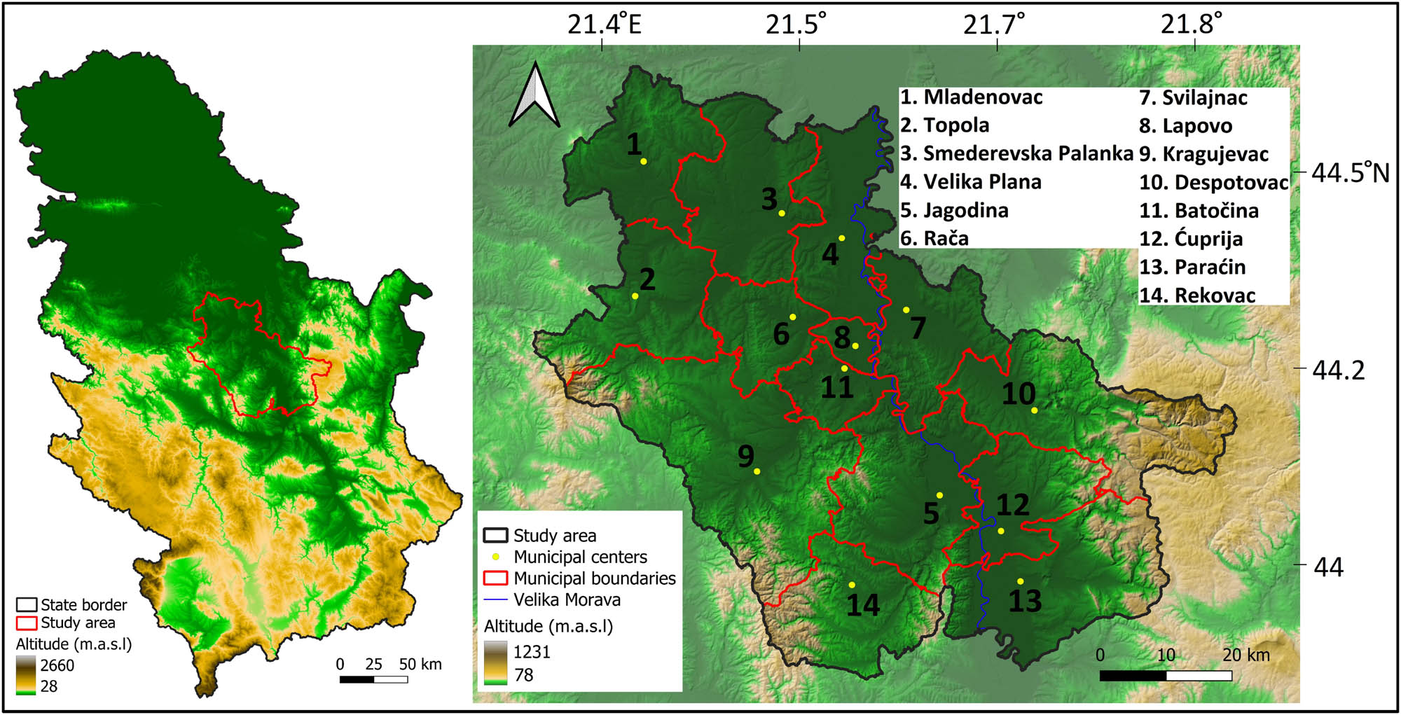
Geographical position of the municipalities in Central Serbia.
2.2 Physical-geographical characteristics of the study area
The study area is situated between the Carpathian–Balkan mountain system to the east and southeast, and the Serbian–Macedonian Massif extending across the western and central parts [44]. The dominant morpho-hydrological unit is the valley of the Velika Morava River. The main morphometric feature is the uniform elevation and the predominance of the hypsometric zone between 100 and 200 m a.s.l. The most widespread geological formations are Neogene sediments and alluvium, which cover about 50% of the total area and are primarily located in the lower elevation zones [45]. The predominant soil types in the basin are Eutric Cambisol and Vertisol, with Fluvisol and Humic Fluvisol also found in the alluvial plains of the Velika Morava [46].
2.3 Socio-geographical characteristics of the study area
Urban centers are located along the Velika Morava Valley (along Pan-European Corridor X) and in the valleys of its larger tributaries. The rural areas of these municipalities comprise 349 rural settlements. The highest number of rural settlements is found in the municipalities of Kragujevac (56), Jagodina (52), and Paraćin (34). The area is characterized primarily by differing levels of depopulation and deagrarianization. The total rural population (RP) decreased by 29% between 1961 and 2011 (from 411,810 to 288,826 inhabitants) [43]. In 1971, the rural area of Central Serbia had 352,292 ha of agricultural land, with arable land accounting for a significant portion (61%). Agricultural land distribution was particularly characterized by land parcels larger than 1,000 ha. By 2012, the total area of agricultural land had decreased to 215,450 ha, with a predominance of land categories smaller than 500 ha. In 1971, the study area had 214,454 ha of arable land, while in 2012, it had 169,708 ha. Thus, arable land decreased by 21% over the observed period. However, the share of arable land within the total agricultural land increased to 78% [47].
2.4 Dataset
Data on average annual gross erosion (Ws) and the erosion coefficient (Z) for the year 1971 were obtained from of the Erosion Map of Serbia 1:500,000 [48]. Data on mean elevation (A) and terrain slope (I) were derived from the 25 m digital elevation model (EU–DEM) [49]. The basic geological map at a scale of 1:100,000 was used to estimate the soil resistance coefficient (Y) and to identify the share of Neogene sediments in rural settlements [50]. The CORINE Land Cover 2018 database [51] was used to quantify the soil protection coefficient (X) and the proportion of forest cover in rural settlements. Landsat 8 satellite images were utilized to calculate the erosion and stream network development coefficient (ϕ) [52] using the bare soil index (BSI). The spatial resolution of the satellite images employed in this study was 30 m × 30 m. The BSI index calculation was carried out using several mathematical operations within the QGIS program [53].
where B6 (Band 6) is a shortwave infrared spectral channel, B4 (Band 4) is a red spectral channel, B5 (Band 5) is a near-infrared spectral channel, and B2 (Band 2) is a blue spectral channel.
Anthropogenic influence was determined by indicators that best reflect the impact of land use changes, as well as the effects of long-term demographic trends in Central Serbia. For the calculation of demographic indicator, data from the Statistical Office of the Republic of Serbia for the period 1971–2011 were used, while data on agricultural and arable land from the Statistical Office for the period 1961–2012 were used for the calculation of agrarian-geographical indicators [47]. The analysis included two agrarian-geographical indicators: the change in agricultural land (Index AgL) and the change in arable land (Index ArL). The demographic indicator is the change in RP (Index RP). These indicators were standardized to the level of rural settlement.
For the purpose of geospatial differentiation of municipalities in the study area, several geographical indicators were selected [45]. In order to quantify the influence of natural conditions in the agrarian landscape of Central Serbia, the following physical-geographical indicators were selected: the specific annual gross erosion (Ws, m3/km2/year), the erosion coefficient (Z), Neogene sediments and alluvium (NSA, %), average elevation (A av, m a.s.l.), and forest cover (F, %). These indicators were standardized to the level of municipality. QGIS 3.8.0 was used for data collection, analysis, and visualization.
2.5 Erosion assessment
Over the past few decades, various models have been developed to assess soil erosion intensity, with a steady increase in related research [54]. Some models emphasize spatial components [55], while others prioritize temporal dynamics [56]. However, these models face limitations, including the complexity of erosion processes, spatial heterogeneity, and insufficient data [57]. Additionally, many models are constrained by their geographic specificity, making them unsuitable for application in regions with different environmental conditions [57,58,59].
In this study, the erosion process's intensity was calculated using the erosion potential model (EPM), also known as the Gavrilović method [60]. The EPM provides a reliable assessment of soil erosion rates, mean annual soil loss, sediment yield, erosion control measures, and torrent regulation at a regional scale. It is particularly useful in areas where detailed erosion data are scarce. However, while it offers practical advantages, the EPM does not thoroughly account for the complex physical processes underlying soil erosion [61]. Using this method, average annual gross soil erosion (W – m3/year) can be calculated as [36,48,60]
where T is the temperature coefficient, t is the mean annual air temperature (°C), H is the mean annual precipitation (mm), Z is the erosion coefficient, and A is the watershed area (km2). The temperature coefficient is calculated as follows:
and the erosion coefficient (Z) is calculated as
where Y is the coefficient of soil resistance, X is the soil protection coefficient, φ is the erosion and stream network development coefficient, and I is the average slope (%).
2.6 Shift-share analysis method (the method of proportional changes)
In order to determine the impact of deagrarianization on the spatial and temporal variability of soil erosion, types of agricultural land use changes were identified. Changes in total agricultural land area in the rural regions of Central Serbia during the period 1961–2012 served as the main starting criterion. The shift-share analysis method was used. This method is employed in economic research [62,63,64,65,66,67,68,69], research of tourist activity [70], agri-geographical studies [60,69,71,72], and demographic studies [73,74,75,76,77]. Its popularity can be partly attributed to its relative simplicity and ease of implementation, reliance on readily available data, and the generation of results that are clear and easy to interpret [67,78]. This method is increasingly being used in studies that explain changes in soil erosion through population and agrarian changes [79,80,81].
The change in agricultural land
where
The regional development component
The net relative change
According to the net relative change in agricultural areas during the period 1961–2012 (AR j ), four main settlement types were identified. The types of agricultural area changes are defined as the percentage of net relative change (AR j ) for each rural settlement individually [76,82]. The settlement types are defined as follows: Progressive type (AR j > 37.9%), stagnant type (0 < AR j < 37.9%), regressive type (0 > AR j > −37.9), and dominantly regressive type (DR) (AR j < −37.9%).
2.7 Statistical analyses
2.7.1 Agglomerative hierarchical clustering (AHC)
Research indicates the application of cluster analysis (CA) in geographical studies of soil erosion, where it is employed to classify risk levels, identify priority zones, group areas with similar erosion characteristics, and determine the dominant contributing factors [83,84]. This approach significantly enhances the accuracy and efficiency of soil erosion assessment and management.
CA was applied to spatially differentiate municipality areas based on nine selected variables (Table 2). In this analysis, an agglomerative hierarchical method was employed, where each municipality initially functions as a separate group [85]. The primary objective of the applied method was to group the objects (municipalities) in a way that maximizes similarity within the formed clusters. This achieves a high degree of internal homogeneity while simultaneously maintaining pronounced heterogeneity between clusters [86,87]. The spatial similarities among the analyzed municipalities were visually represented through a hierarchical tree (dendrogram), which illustrates the structure of the clusters formed as a result of the analysis. For the hierarchical clustering, Ward’s method combined with squared Euclidean distance was used, as it is well-suited for this type of spatial analysis [88].
2.7.2 Index number method
The criteria analysis of the research included a temporal component based on index numbers. This method was used to determine the intensity of changes in specific indicators during the analyzed period. Index numbers are calculated using the following formula [45]:
where Index P is the change index; P 0 is the value of the indicator in the initial year; and P 1 is the value of the indicator in the final (last) year. The change indices are classified according to the following scale: high index < 10; medium-high index = 10–30; medium index = 30–50; medium-low index = 50–70; low index > 70–100, and growth index > 100.
3 Results and discussion
3.1 Spatio-temporal analysis of changes in soil erosion intensity in relation to the agrarian-geographical transformation of rural settlements
Our comparative quantitative analysis of the two-time series showed a decrease in erosion intensity in the Central Serbia (Figure 2). The results of the EPM model showed that the specific annual gross erosion was Ws1 = 1,012 m3/km2/year in 1971 (Figure 2a) and Ws2 = 718 m3/km2/year in 2011 (Figure 2b). This meant that during the period of 1971–2011, the intensity of soil erosion decreased by 29%.
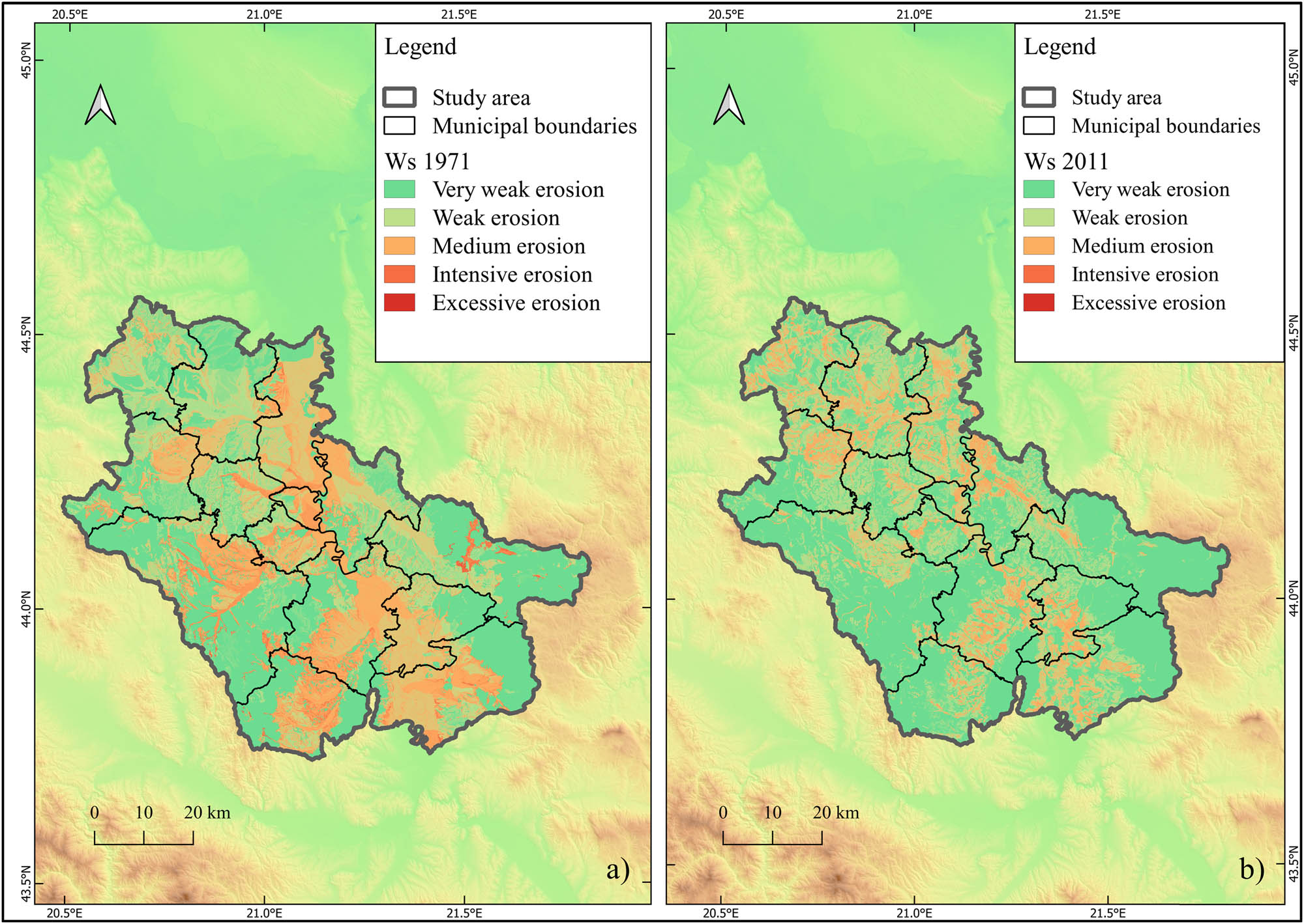
Map of specific annual gross erosion (Ws) in 1971 (a) and 2011 (b). Legend: Very weak erosion – category V (0–400 m3/km2/year); weak erosion – category IV (400–800 m3/km2/year); medium erosion – category III (800–1,200 m3/km2/year); intensive erosion – category II (1,200–3,000 m3/km2/year); excessive erosion – category I (>3,000 m3/km2/year).
The typology of settlements according to the change in agricultural land is given in Figure 3. Progressive change in agricultural land areas (AgL), characterized by a positive net relative change value (PR j > 37.9%), is recorded in only 11 settlements (3.1%), without a continuous distribution area. Stagnant change in agricultural land areas (S), with a positive net relative change (0 < PR j < 37.9%), is present in 141 settlements (40.3). Stagnant settlements are widely distributed in the northern half of the study area (municipalities Smederevska Palanka, Mladenovac, Velika Plana, Topola). Smaller areas are located in the Velika Morava River valley (municipalities of Paraćin, Ćuprija, and Jagodina). Despite the positive net relative change, these rural settlements are characterized by a moderate decline in agricultural land area. Regressive change in agricultural land areas (R) is associated with a negative net relative change (0 > PR j > −37.9%). In fact, the majority of rural settlements in Central Serbia belong to the regressive type – 182 settlements (52.3%). Regressive-type settlements are predominantly concentrated in the southern part of the study area. A rough dividing line between regressive and stagnant-type settlements can be drawn on the map – this is the Svilajnac–Lapovo–Kragujevac line. Smaller clusters of regressive-type settlements are located around Topola and north of Mladenovac. A very small number of rural settlements of the DR are located in the higher peripheral parts of the study area (15 settlements – 4.3%).
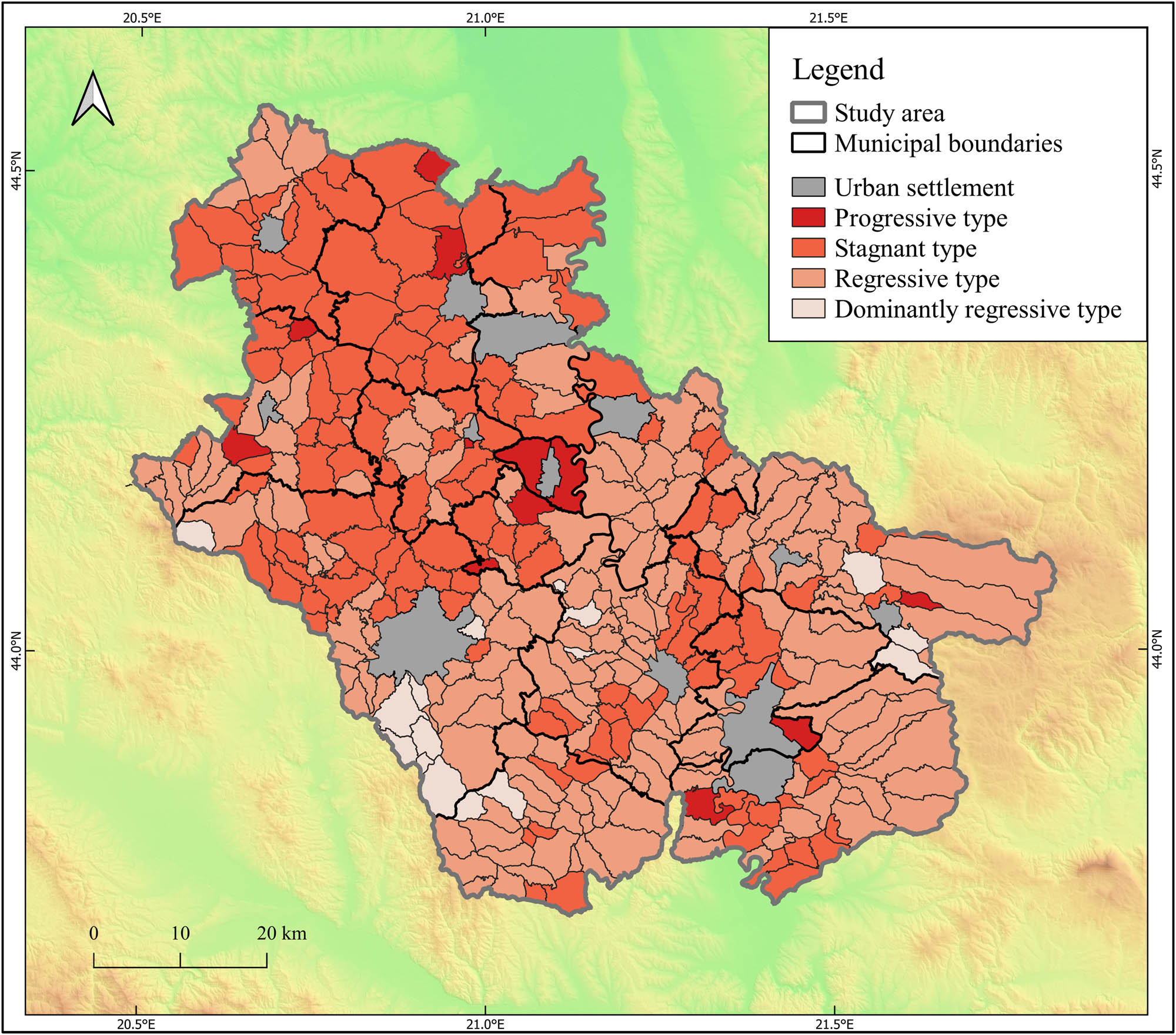
Types of settlements according to changes in agricultural land in Central Serbia (1961–2012).
3.1.1 Progressive type
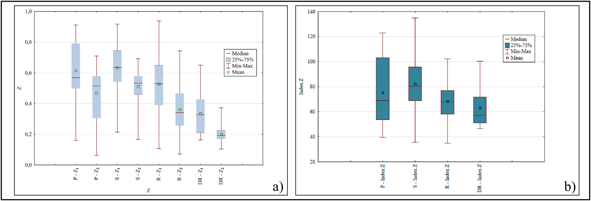
The average erosion coefficient Z in the first period was Z 1 = 0.616, and after a 40-year period, it decreased to Z 2 = 0.468 (Figure 4a). This 24% reduction in erosion intensity (Index Z = 76) (Figure 4b) was accompanied by a 29% decrease in average specific gross erosion (Index Ws = 71). Thus, the average specific gross erosion decreased from Ws1 = 1,198 m3/km2/year to Ws2 = 856 m3/km2/year (Figure 5a and b).
The erosion coefficient (Z) in 1971 and 2011 (a) and the changes in the erosion coefficient (1971–2011) (b) according to the typological classification of rural settlements (P – progressive type; S – stagnant type; R – regressive type; and DR – dominantly regressive type).
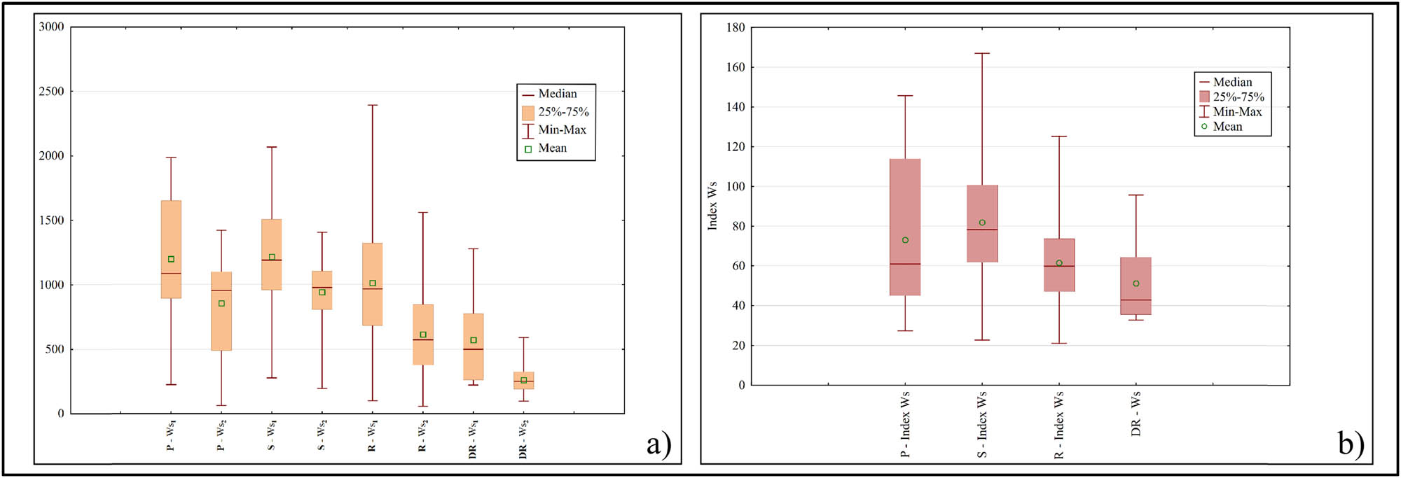
The specific annual gross erosion (Ws) in 1971 and 2011 (a) and the changes in the specific annual gross erosion (1971–2011) (b) according to the typological classification of rural settlements (P – progressive type; S – stagnant type; R – regressive type; and DR – dominantly regressive type).
In general, the specific characteristic of soil erosion intensity in 1971 was the absence of the highest category of the average specific gross erosion (>3,000 m3/km2/year). In the progressive type, five settlements were affected by Category II soil erosion (1,200–3,000 m3/km2/year). The remaining six settlements were affected by Category III (800–1,200 m3/km2/year) and Category IV (400–800 m3/km2/year) (Figure 6a). In 2011, Category III erosion (800–1,200 m3/km2/year) dominated this type of settlement, with a total share of 64% (seven settlements) (Figure 6b). On the other hand, there was a significant reduction in Category II erosion (1,200–3,000 m3/km2/year), which was present in only 9% of the total number of settlements (one settlement).
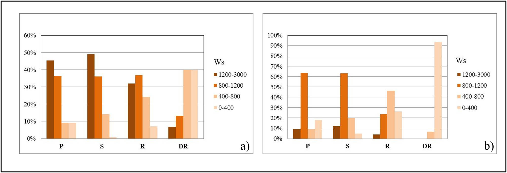
Percentage distribution of erosion category Ws (m3/km2/year) according to the typological classification of rural settlements in (a) 1971 and (b) 2011.
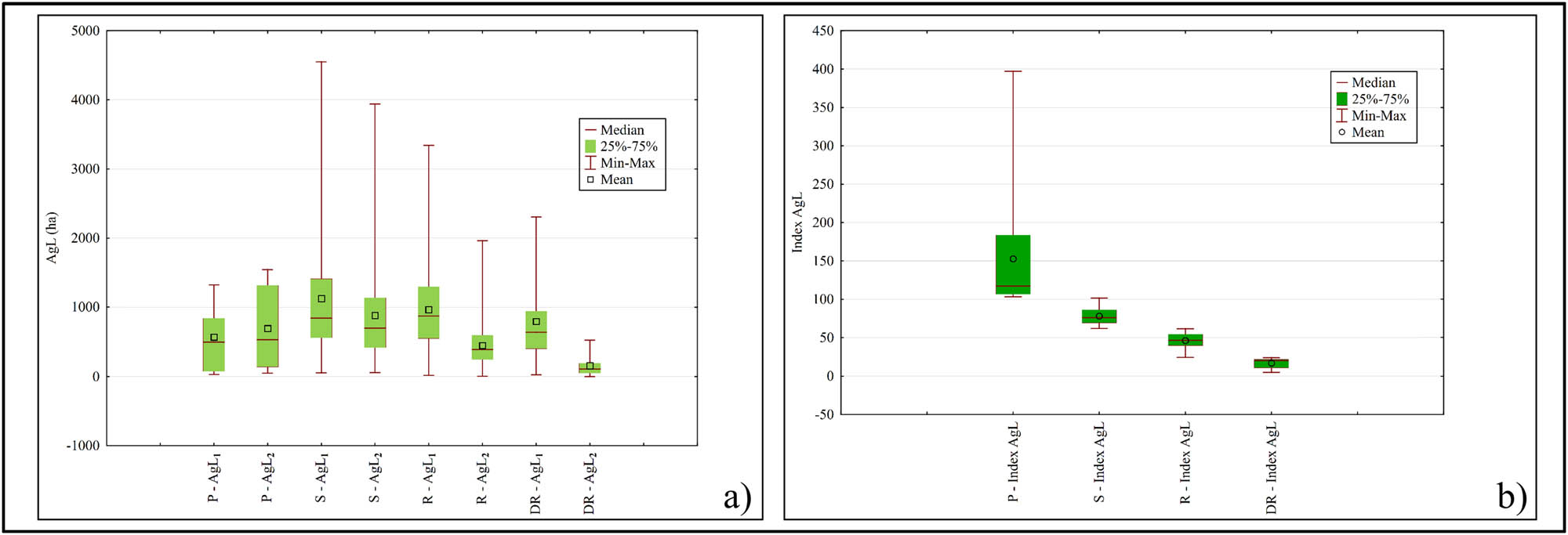
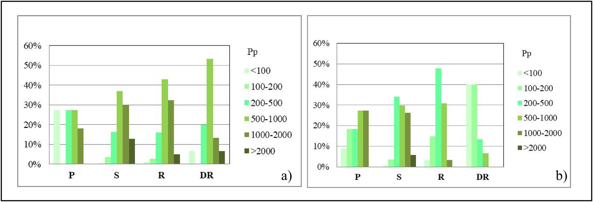
In the progressive type, agricultural land increased by 21% (Index AgL = 121) (Figure 7b). These settlements had AgL1 = 6,251 ha in 1961, while in 2012, the area of agricultural land increased to AgL2 = 7,616 ha (Figure 7a). During the analyzed period, the number of settlements with 1,000–2,000 ha of agricultural land increased, while the share of those with 200–500 ha decreased (Figure 8). Within the structure of agricultural land, arable land increased by 23% during the analyzed period (1971: ArL1 = 4,567 ha; 2012: ArL2 = 5,631 ha). The population remained stable over time (1961: RP1 = 12,057 inhabitants; 2012: RP2 = 11,980 inhabitants) (Table 1). This implies that the population is more oriented toward nearby urban centers than toward agriculture. In this case, urbanization has caused dysfunction in the use of agricultural land [89]. The increase in land resources did not result in increased soil erosion. The specific sediment yield has decreased.
Agricultural land AgL (ha) in 1961 and in 2012 (a) and changes in the agricultural land (1961–2012) (b) according to the typological classification of rural settlements (P – progressive type; S – stagnant type; R – regressive type; and DR – dominantly regressive type).
Distribution of agricultural land AgL (ha) in 1961 (a) and 2012 (b) according to the typological classification of rural settlements (P – progressive type; S – stagnant type; R – regressive type; and DR – dominantly regressive type).
Arable land ArL (ha) and RP according to the typological classification of rural settlements
| Type of rural settlements | ArL | RP | ||
|---|---|---|---|---|
| 1961 | 2012 | 1971 | 2011 | |
| P | 4,567 | 5,631 | 12.057 | 11.980 |
| S | 108.958 | 104.069 | 195.751 | 137.467 |
| R | 96.733 | 59.182 | 193.352 | 135.478 |
| DR | 4,196 | 826 | 10.650 | 3,901 |
Note: P – progressive type; S – stagnant type; R – regressive type; DR – dominantly regressive type.
3.1.2 Stagnant type
In settlements of the stagnant type, the intensity of the average erosion coefficient Z in 1971 was Z 1 = 0.633, while in 2011, it was Z 2 = 0.511 (Figure 4a). The average specific gross erosion was Ws1 = 1,215 m3/km2/year in 1971, and Ws2 = 942 m3/km2/year in 2011 (Figure 5a). A decrease in erosion intensity by 19% (Index Z = 81) (Figure 4b) and a decrease in specific gross erosion by 23% (Index Ws = 77) are the key characteristics of this settlement area (Figure 5b).
In this type of settlement, in 1971, the II erosion category (1,200–3,000 m3/km2/year) was absolutely dominant. Of the total number of settlements, 49% were affected by this erosion category (Figure 6a). The reduction in the intensity of II category erosion resulted in an increase in areas under III category erosion in 2011. The majority of settlements had an average specific gross erosion of 800–1,200 m3/km2/year (63%) (Figure 6b). This category was the main driver of the erosion process in this type of settlement.
In the stagnant settlement type, the reduction in soil erosion was corresponded to the degree of change in agricultural land (22%, Index AgL = 78) (Figure 7b). In 1961, these settlements had a total of AgL1 = 158,800 ha of agricultural land. After a reduction in the agricultural land fund, in 2012 these settlements had AgL2 = 124,451 ha (Figure 7a). In the distribution of agricultural land categories, a twofold increase in the number of settlements with areas ranging from 200 to 500 ha was recorded. On the other hand, the number of settlements with more than 2,000 ha almost halved. The stability of the agricultural land fund in this type was determined by settlements with areas in the categories of 500–1,000 ha and 1,000–2,000 ha (Figure 8). No significant changes occurred in these categories.
The large fund of arable land in 1971 (ArL1 = 108,958 ha) slightly decreased in 2012 (ArL2 = 104,069 ha) (Table 1). Population changes were reflected in a 30% decrease in population (Index RS = 70). At the beginning of the analyzed period, this settlement area had RP1 = 195,751 inhabitants, and by the end RP2 = 137,467 inhabitants (Table 1). Therefore, the process of depopulation was more pronounced than the process of deagrarianization of agricultural land [90]. This is a direct consequence of the intensification of agricultural production influenced by the agrarian market from the surrounding urban centers [91].
3.1.3 Regressive type
Compared to the previous two types of settlements, the regressive type experienced greater changes in the intensity of erosion. The results show that the strength of the erosive process decreased by 32% (Index Z = 68) (Figure 4b). More precisely, this means that the erosion coefficient decreased from Z 1 = 0.528 to Z 2 = 0.360 (Figure 4a). The average specific gross erosion decreased by 39% (Index Ws = 61) (Figure 5b), i.e., from Ws1 = 1,013 m3/km2/year to Ws2 = 614 m3/km2/year (Figure 5a).
In this type of settlement, in 1971, about 37% of the settlements had a specific gross erosion of 800–1,200 m3/km2/year. However, a large proportion of the settlements (32%) were affected by the II erosion category (1,200–3,000 m3/km2/year) (Figure 6a). A specific characteristic of the second period is the highest number of settlements with sediment yield in the IV category (400–800 m3/km2/year), and a uniform spatial distribution of the III category (800–1,200 m3/km2/year) and V category (0–400 m3/km2/year) (Figure 6b).
This type experienced a significant reduction in agricultural land area (54%, Index AgL = 46) (Figure 7b). In 1961, these settlements had AgL1 = 175,322 ha, and by 2012, this had decreased to AgL2 = 81,063 ha (Figure 7a). In 1961, the absolute majority of settlements had between 500 and 1,000 ha (43%) (Figure 8). By 2012, the dominant category of agricultural land became 200–500 ha (48%). The largest reductions were identified in the highest categories of agricultural land. The category of 1,000–2,000 ha decreased tenfold over time. Settlements that had more than 2,000 ha in 1961 (5%) were no longer present in 2012 (Figure 8).
The significant reduction in agricultural land was accompanied by a substantial reduction in arable land. At the beginning of the analyzed period, the arable land fund amounted to ArL1 = 96,733 ha, and by the end of the period, it had decreased to ArL2 = 59,182 ha. RP trends moved toward decline. In 1961, this area was home to RP1 = 193,352 residents, while in 2011, the number had decreased to RP2 = 135,478 residents (Table 1).
3.1.4 Dominantly regressive type
A 41% reduction in the erosion coefficient (Index Z = 59) (Figure 4b) was accompanied by a larger decrease in the average specific gross erosion of 55% (Index Ws = 45) (Figure 5b). The intensity of the erosion process decreased over time from Z 1 = 0.334 in 1971 to Z 2 = 0.197 in 2011 (Figure 4a). The average specific gross erosion was Ws1 = 572 m3/km2/year in the first observation period, and Ws2 = 261 m3/km2/year in the second (Figure 5a).
In the majority of settlements of the DR, the lowest categories of the average specific gross erosion were present. Therefore, even at that time, the dominantly regressive settlement type experienced the least intense erosion (Figure 6a). Corresponding to the most significant decline in soil erosion, by 2011, this type of settlement encompassed only the two lowest erosion categories. In other words, in this settlement area, over 90% of the settlements had the average specific gross erosion in Category V (0–400 m3/km2/year) (Figure 6b).
With an 81% reduction in agricultural land (Index AgL = 19), this type of settlement has almost completely lost the basic characteristics of an agrarian landscape (Figure 7b). More precisely, agricultural land decreased from AgL1 = 11,919 ha in 1961 to AgL2 = 2,320 ha in 2012 (Figure 7a). A key feature of the distribution of agricultural land categories in 1961 was the dominance of the 500–1,000 ha category (53%) and the absence of the 100–200 ha category. Negative changes in 2012 affected not only the total reduction in agricultural land but also triggered an intense process of agricultural land fragmentation. This is highlighted by the fact that in 2012, 80% of all settlements of this type had less than 200 ha of agricultural land. At that time, there were no settlements with over 1,000 ha of agricultural land in this type (Figure 8).
Deagrarianization was more intense in arable land. The total fund of arable land was reduced fivefold. In 1971, the population in this settlement area had ArL1 = 4,196 ha of arable land at its disposal, while by 2012, the fund had decreased to ArL2 = 826 ha. The strongest process of deagrarianization was accompanied by the greatest population decline (63%). More precisely, this means that in 1961, there were RP1 = 10,650 inhabitants in this settlement area, and in 2011, RP2 = 3,901 inhabitants (Table 1).
3.2 Spatial differentiation and clustering of soil erosion intensity in municipalities of Central Serbia
The results of the CA showed that the selected municipalities in Central Serbia are grouped into three clusters. Three clusters can be distinguished on the dendrogram (Figure 9).
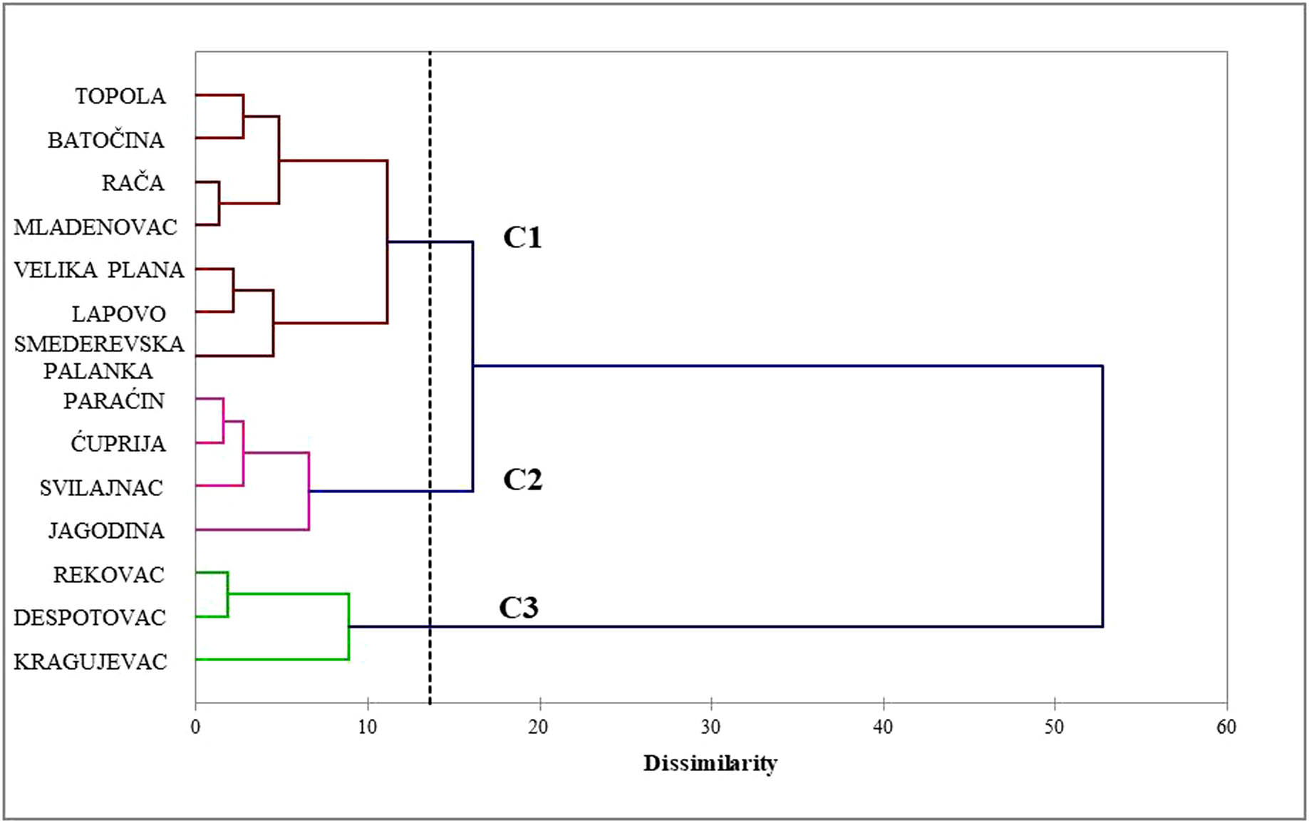
Dendrogram representing municipalities classification by CA. Algorithms: Dissimilarity – Euclidian distance; Agglomeration method – Wards method.
The spatial distribution of the municipalities determined using the CA is shown in Figure 10. The main characteristics of the clusters are presented in Table 2.
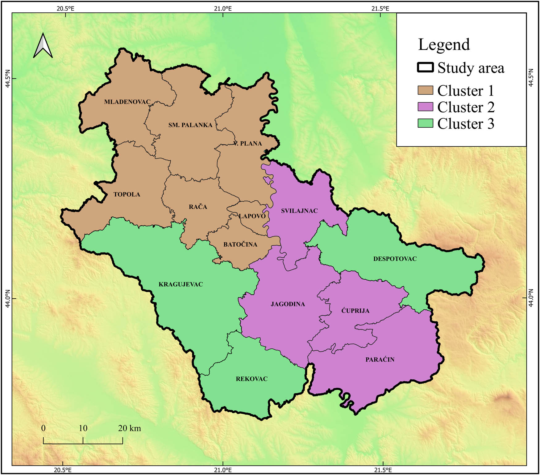
The spatial differentiation of the municipalities using CA in Central Serbia.
Controlling variables used in the AHC
| Variables – Abbreviation (units) | Clusters | ||
|---|---|---|---|
| I | II | III | |
| The average specific gross erosion – Ws (m3/km2/year) | 949.8 | 785.0 | 509.1 |
| The average erosion coefficient – Z (−) | 0.516 | 0.437 | 0.312 |
| Sediments of Neogene – NSA (%) | 39.4 | 42.2 | 15.6 |
| Mean altitude – A av (m) | 181.7 | 225.4 | 384.7 |
| Forest cover – F (%) | 11.2 | 27.8 | 39.7 |
| Progressive type – P (number of settlements) | 8 | 2 | 1 |
| Stagnant type – S (number of settlements) | 67 | 38 | 36 |
| Regressive type – R (number of settlements) | 35 | 78 | 69 |
| Dominantly regressive type – DR (number of settlements) | 0 | 3 | 12 |
A high proportion of between-class variance (78.54%) compared to within-class variance (21.46%) indicates the high efficiency of the applied classification [92,93]. The clear separation between groups implies that the majority of the total variability in the data can be attributed to differences between classes rather than random deviations within them. These results suggest that the classification largely succeeds in reflecting the structural characteristics of the observed dataset.
The first cluster (d:11.1) is the largest in terms of area and covers the central and northern parts of the study area. It includes seven municipalities: Batočina, Lapovo, Mladenovac, Rača, Smederevska Palanka, Topola, and Velika Plana (Figure 10). The rural area of this cluster consists of 110 rural settlements. A specific feature of this cluster is the average specific gross erosion Ws = 949.8 m3/km2/year and the intensity of the erosion process Z = 0.516. The average elevation is Hsr = 182 m. The Sediments of Neogene (NSA) lithological complex occupies about 40% of the cluster’s area. Forests cover 11% of the cluster’s area.
According to the typology of rural settlements, the majority belong to the stagnant type (61%), indicating that there were no significant changes in the use of agricultural land during the analyzed period. Also, a specific feature of this cluster compared to others is the highest number of progressive settlements. Settlements of DR are absent.
The municipalities in this cluster represent the strongest agrarian region (AgL = 101,829 ha), with high demographic potential (RP = 141,667) and extensive agricultural land. However, due to a lower percentage of forest cover and a higher share of Neogene sediments, this area is exposed to the highest intensity of erosion. The results indicate that this is the zone with the potentially greatest risk of land degradation. In terms of agrarian characteristics, this cluster shows some development potential, especially considering the absence of strongly regressive settlements.
The second cluster (d:6.5) is the most homogeneous and includes four municipalities: Ćuprija, Jagodina, Paraćin, and Svilajnac. These municipalities occupy the central parts of the study area and comprise 121 rural settlements. The key characteristics of this cluster are the average specific gross erosion Ws = 785 m3/km2/year and the average erosion coefficient Z = 0.437. The average elevation is Hsr = 225 m. The NSA lithological complex covers about 42% of the cluster’s area, and forests cover 28%.
In terms of agricultural land use dynamics, this is the cluster with the highest number of regressive settlements. Of the total number of settlements in this cluster, 65% are regressive (78 settlements). Although the majority of settlements experienced a reduction in agricultural land from 1961 to 2012, a significant number of stagnant settlements maintain relative agrarian stability in the area. Stagnant settlements make up one-third of the total number in this cluster.
The municipalities located in the central part of the study area represent a stable, agriculturally oriented region, with agricultural land AgL = 56750.7 ha and RP 88,989.
The third cluster (d:8.8) includes three municipalities: Despotovac, Kragujevac, and Rekovac. These municipalities are located on the southeastern and southwestern peripheries of the study area and consist of 118 settlements. This cluster is characterized by the lowest specific gross erosion (Ws = 509 m3/km2/year) and the lowest erosion intensity (Z = 0.312). It has the lowest share of Neogene sediments (15.6%), the highest average elevation (385 m a.s.l.), and the highest forest cover (40%), which are the key physical-geographic features of this settlement area.
Of the total number of settlements, 58% are of regressive type. A distinguishing feature of the agrarian landscape in this cluster compared to the previous two is the highest number of predominantly regressive settlements (12).
The municipalities in the southern part of the study area have the most favorable natural conditions for soil protection, but face significant demographic and agrarian challenges. This is the cluster with the lowest population (RP = 58,170). The higher elevation and greater forest coverage reduce erosion, but the large number of regressive settlements indicates a decline of rural areas and a decrease in agricultural activity. These trends highlight the need for targeted agricultural policy measures tailored to the specific characteristics of each cluster.
Soil erosion, as a global environmental challenge, has increasingly serious implications for sustainable land management, agricultural productivity, and rural development. The progressive loss of fertile topsoil due to erosion undermines long-term food security and exacerbates ecological degradation. In the context of Serbia – particularly Central Serbia – this issue is closely linked to socio-economic transformations that have unfolded since the mid-twentieth century. During the post-World War II era, Serbia experienced widespread shifts in land use and vegetation cover driven by industrialization and urbanization. While these changes were aimed at improving living standards, they contributed to the depopulation of rural areas and the abandonment of traditional agricultural practices. The resulting land degradation and increased erosion were further intensified by inappropriate land management in areas that remained under cultivation. The findings of this study align with those of Tošić et al. [94] and Wang et al. [95], who emphasize the critical role of socio-economic and anthropogenic factors – such as rural depopulation, agricultural decline, and land abandonment – in influencing erosion dynamics. In Central Serbia, the observed reduction in soil erosion intensity across all types of rural settlements may at first seem counterintuitive. However, this can be largely attributed to widespread land abandonment in less productive areas, which reduces the physical disturbance of soil and allows for some degree of natural vegetation recovery. The spatial differentiation of municipalities, revealed through CA, shows a north-south gradient in erosion risk. The northern municipalities, despite having the highest demographic and agricultural potential, face the most significant threats from land degradation. This suggests that intensive land use and high population density, when not managed sustainably, can amplify erosion risks even in otherwise favorable environmental conditions. Conversely, central and southern regions exhibit more stable or favorable natural conditions for soil protection, though they struggle with demographic decline and reduced agricultural activity. The southern areas, in particular, highlight the paradox of possessing the best natural conditions for sustainable agriculture while facing the greatest socio-economic challenges, including regressive rural settlements and an aging population. Contemporary research by Marković et al. [96] supports the need for region-specific conservation policies that integrate vegetation protection and sustainable land use strategies. Their recommendations provide a useful framework for policymakers to develop long-term soil and water conservation measures tailored to specific basin or regional conditions. Similarly, Panagos et al. [97] and Barbier [98] underscore the importance of aligning ecological initiatives with local socio-economic realities, promoting coordinated approaches that balance environmental goals with development needs. The multidisciplinary methodology applied in this study offers a valuable platform for informing sustainable land management policies. By combining geographic analysis with socio-economic data, it is possible to design targeted interventions. For instance, in areas showing early signs of land abandonment, incentives for continued cultivation and soil preservation could be implemented. Meanwhile, in regions where traditional agriculture is no longer viable, support for rural economic diversification and community revitalization may be more appropriate. Ultimately, this study reinforces the importance of understanding the complex interdependencies between natural conditions, demographic trends, and land use practices. A nuanced, place-based approach is essential for mitigating soil erosion and ensuring the resilience of both rural communities and the ecosystems they depend on, especially in the face of ongoing climate change and socio-economic transformation.
4 Conclusion
This study highlights that agricultural land abandonment and rural depopulation – processes traditionally associated with marginal areas – are now increasingly present even in regions with favorable locational and natural conditions, such as the rural areas of Central Serbia. The observed decrease in soil erosion intensity across various rural settlement types reflects the complex interaction between socio-economic shifts, land use change, and natural factors. The spatial differentiation of municipalities through CA revealed a clear pattern: the risk of soil erosion decreases along a north-south gradient. The northern municipalities, although agronomically and demographically robust, face the highest erosion risk due to intensive land use and developmental pressures. In contrast, the central zone maintains a degree of agricultural stability with moderate development potential, while the southern part, despite having the most favorable natural conditions for soil conservation, is significantly affected by demographic decline and regressive rural development. The research confirms that natural conditions remain a key determinant of spatial land use dynamics and soil erosion patterns. However, socio-economic factors, particularly population trends and agricultural viability, are increasingly influential. This underscores the importance of integrated and place-based policy responses that simultaneously address environmental and rural development challenges. The multidisciplinary approach used in this study – integrating geographic, demographic, and agronomic analyses – offers several advantages. It enables a holistic understanding of erosion processes, supports the identification of spatial patterns, and facilitates the formulation of targeted and region-specific land management strategies. Such insights are invaluable for shaping effective and sustainable policy measures aimed at preserving soil resources while supporting rural livelihoods. However, the study also has several limitations. The use of CA, while effective in identifying general spatial trends, may not capture micro-scale variations or account for short-term land use changes. Additionally, the reliance on historical and aggregate data may obscure emerging or localized processes. The EPM, used as part of the assessment, is practical and suited for data-scarce regions but does not account in depth for the underlying physical mechanisms of erosion, such as hydrological processes, rainfall intensity, or soil structure variations.
To address these limitations, future research should:
Incorporate high-resolution spatial and temporal data (e.g., high-resolution satellite imagery, remote sensing, and GIS-based modeling) to detect more precise changes in land use and erosion patterns.
Integrate climate change scenarios to evaluate how shifting precipitation patterns and temperature regimes may impact soil erosion in the coming decades.
Conduct field-based validations of modeled erosion estimates to increase the accuracy of predictions.
Explore the socio-economic drivers of land abandonment more deeply, particularly through qualitative methods such as interviews or surveys with local populations.
Evaluate the effectiveness of specific soil conservation interventions and rural revitalization programs across different regional contexts.
Hence, the findings of this study contribute valuable insights into the dynamic interplay between natural and socio-economic factors shaping land degradation in Central Serbia. They offer a foundation for the development of adaptive and regionally tailored soil conservation strategies that align with broader goals of rural development and environmental sustainability.
Acknowledgments
This study was supported by the Ministry of Science, Technological Development and Innovation of the Republic of Serbia (Grant Nos 451-03-137/2025-03/200125, 451-03-136/2025-03/200125, and 451-03-136/2025-03/200091).
-
Funding information: This research received no external funding that has supported the work.
-
Author contributions: Conceptualization and methodology: T.S. and M.S.; formal analysis: T.S., S.M., M.S., and E. K.; GIS software and mapping: T.S. and U.D.; technical editing: E.K.; and supervision: S.M. and T.L.; All authors discussed the results and contributed to the final manuscript. All authors have read and agreed to the published version of the manuscript.
-
Conflict of interest: Authors state no conflict of interest.
References
[1] Kuemmerle T, Levers C, Erb K, Estel S, Jepsen M, Müller D, et al. Hotspots of land use change in Europe. Env Res Lett. 2016;11:064020. 10.1088/1748-9326/11/6/064020.Suche in Google Scholar
[2] Kristensen S, Busck A, Sluis T, Gaube V. Patterns and drivers of farm-level land use change in selected European rural landscapes. Land Use Policy. 2016;57:786–99. 10.1016/j.landusepol.2015.07.014.Suche in Google Scholar
[3] Winkler K, Fuchs R, Rounsevell M, Herold M. Global land use changes are four times greater than previously estimated. Nat Commun. 2021;12:2501. 10.1038/s41467-021-22702-2.Suche in Google Scholar PubMed PubMed Central
[4] Shahpari S, Allison J, Harrison M, Stanley R. An integrated economic, environmental and social approach to agricultural land-use planning. Land. 2021;10:364. 10.3390/land10040364.Suche in Google Scholar
[5] Vliet J, Groot H, Rietveld P, Verburg P. Manifestations and underlying drivers of agricultural land use change in Europe. Landsc Urban Plan. 2015;133:24–36. 10.1016/j.landurbplan.2014.09.001.Suche in Google Scholar
[6] Piquer-Rodríguez M, Butsic V, Gärtner P, Macchi L, Baumann M, Pizarro G, et al. Drivers of agricultural land-use change in the Argentine Pampas and Chaco regions. Appl Geogr. 2018;91:111–22. 10.1016/j.apgeog.2018.01.004.Suche in Google Scholar
[7] Theobald D, Kennedy C, Chen B, Oakleaf J, Baruch-Mordo S, Kiesecker J. Earth transformed: Detailed mapping of global human modification from 1990 to 2017. Earth Syst Sci Data. 2020;12:1953–72. 10.5194/essd-12-1953-2020.Suche in Google Scholar
[8] Levers C, Schneider M, Prishchepov A, Estel S, Kuemmerle T. Spatial variation in determinants of agricultural land abandonment in Europe. Sci Total Env. 2018;644:95–111. 10.1016/j.scitotenv.2018.06.326.Suche in Google Scholar PubMed
[9] Sabljić L, Delić D. The challenge of assessing the spatial transformation caused by mining in B&H – GIS as a solution? In 9th International Scientific Conference GEOBALCANICA 2023; 2023. p. 71–8. 10.18509/GBP23071.Suche in Google Scholar
[10] Creutzig F, d’Amour CB, Weddige U, Fuss S, Beringer T, Gläser A, et al. Assessing human and environmental pressures of global land-use change 2000–2010. Glob Sustain. 2019;2:e1. 10.1017/sus.2019.Suche in Google Scholar
[11] Nikodemus O, Bell S, Grīne I, Liepiņš I. The impact of economic, social and political factors on the landscape structure of the Vidzeme Uplands in Latvia. Landsc Urban Plan. 2005;70(1–2):57–70.10.1016/j.landurbplan.2003.10.005Suche in Google Scholar
[12] Griffiths P, Müller D, Kuemmerle T, Hostert P. Agricultural land change in the Carpathian ecoregion after the breakdown of socialism and expansion of the European Union. Env Res Lett. 2013;8:045024. 10.1088/1748-9326/8/4/045024.Suche in Google Scholar
[13] Pasakarnis G, Morley D, Maliene V. Rural development and challenges establishing sustainable land use in Eastern European countries. Land Use Policy. 2013;30:703–10. 10.1016/j.landusepol.2012.05.009.Suche in Google Scholar
[14] Pazúr R, Lieskovský J, Feranec J, Oťaheľ J. Spatial determinants of abandonment of large-scale arable lands and managed grasslands in Slovakia during the periods of post-socialist transition and European Union accession. Appl Geogr. 2014;54:118–28. 10.1016/j.apgeog.2014.07.014.Suche in Google Scholar
[15] Živanović V, Joksimović M, Golić R, Malinić V, Krstić F, Sedlak M, et al. Depopulated and abandoned areas in Serbia in the 21st century – From a local to a national problem. Sustainability. 2022;14(17):10765. 10.3390/su141710765.Suche in Google Scholar
[16] Kupková L, Bičík I, Jeleček L. At the crossroads of European landscape changes: Major processes of landscape change in Czechia since the middle of the 19th century and their driving forces. Land. 2021;10(1):34. 10.3390/land10010034.Suche in Google Scholar
[17] Lieskovský J, Lieskovská D. Cropland abandonment in Slovakia: Analysis and comparison of different data sources. Land. 2021;10(4):334. 10.3390/land10040334.Suche in Google Scholar
[18] Dobrynin D, Vorbrugg A, Hujala T. Forestry on abandoned agricultural land: Future options for Russia. Land Use Policy. 2025;150:107435. 10.1016/j.landusepol.2024.107435.Suche in Google Scholar
[19] Bajić D, Adžić D, Sabljić L. Winter crops classification using combination of multi-temporal optical Sentinel-2 and radar Sentinel-1 images. Glasnik/Herald. 2022;26:27–50. 10.7251/HER2226027B.Suche in Google Scholar
[20] Sabljić L, Lukić T, Bajić D, Marković R, Spalević V, Delić D, et al. Optimizing agricultural land use: A GIS-based assessment of suitability in the Sana River Basin, Bosnia and Herzegovina. Open Geosci. 2024;16(1):20220683. 10.1515/geo-2022-0683.Suche in Google Scholar
[21] Hatna E, Bakker M. Abandonment and expansion of arable land in Europe. Ecosystems. 2011;14:720–31. 10.1007/s10021-011-9441-y.Suche in Google Scholar
[22] Hu Q, Xiang M, Chen D, Zhou J, Wu W, Song Q. Global cropland intensification surpassed expansion between 2000 and 2010: A spatio-temporal analysis based on GlobeLand30. Sci Total Env. 2020;746:141035. 10.1016/j.scitotenv.2020.141035.Suche in Google Scholar PubMed
[23] Van Rompaey A, Govers G, Verstraeten G, van Oost K, Poesen J. Modelling the geomorphic response to land use changes. In: Lang A, Dikau R, Hennrich K, editors. Long term hillslope and fluvial system modelling: concepts and case studies from the Rhine river catchment. Berlin: Springer; 2003. p. 73–100.10.1007/3-540-36606-7_5Suche in Google Scholar
[24] Owens PN. Soil erosion and sediment dynamics in the Anthropocene: a review of human impacts during a period of rapid global environmental change. Earth Surf Process Landf. 2020;45(1):157–82. 10.1002/esp.4722.Suche in Google Scholar
[25] Tsegaye L, Bharti R. Assessment of the effects of agricultural management practices on soil erosion and sediment yield in Rib watershed, Ethiopia. Int J Env Sci Technol. 2023;20(1):503–20.10.1007/s13762-022-04018-wSuche in Google Scholar
[26] Nedd R, Anandhi A. A synthesis on land degradation in the context of sustainable development goals. Land Degrad Dev. 2024;35(13):3937–64. 10.1002/ldr.5168.Suche in Google Scholar
[27] Aulakh MS, Sidhu GS. Soil degradation in India: Causes, major threats, and management options. In MARCO Symposium 2015 – Next Challenges of Agro-Environmental Research in Monsoon Asia. Japan: 2015. p. 151–6.Suche in Google Scholar
[28] Fenta AA, Tsunekawa A, Haregeweyn N, Poesen J, Tsubo M, Borrelli P, et al. Land susceptibility to water and wind erosion risks in the East Africa region. Sci Total Env. 2020;703:135016. 10.1016/j.scitotenv.2019.135016.Suche in Google Scholar PubMed
[29] Hurni H, Tato K, Zeleke G. The implications of changes in population, land use, and land management for surface runoff in the upper Nile basin area of Ethiopia. Mt Res Dev. 2005;25(2):147–54.10.1659/0276-4741(2005)025[0147:TIOCIP]2.0.CO;2Suche in Google Scholar
[30] Kidane M, Bezie A, Kesete N, Tolessa T. The impact of land use and land cover (LULC) dynamics on soil erosion and sediment yield in Ethiopia. Heliyon. 2019;5(12):e02981.10.1016/j.heliyon.2019.e02981Suche in Google Scholar
[31] Ebabu K, Tsunekawa A, Haregeweyn N, Adgo E, Meshesha D, Aklog D, et al. Effects of land use and sustainable land management practices on runoff and soil loss in the Upper Blue Nile basin, Ethiopia. Sci Total Env. 2019;648:1462–75. 10.1016/j.scitotenv.2018.08.273.Suche in Google Scholar
[32] Tadesse A, Hailu W. Causes and consequences of land degradation in Ethiopia: a review. Int J Sci Qual Anal. 2024;10(1):10–21. 10.11648/j.ijsqa.20241001.12.Suche in Google Scholar
[33] Wang L, Xiao Y, Rao E, Jiang L, Xiao Y, Ouyang Z. An assessment of the impact of urbanization on soil erosion in Inner Mongolia. Int J Env Res Public Health. 2018;15(3):550. 10.3390/ijerph15030550.Suche in Google Scholar PubMed PubMed Central
[34] Riquetti N, Beskow S, Guo L, Mello C. Soil erosion assessment in the Amazon basin in the last 60 years of deforestation. Env Res. 2023;236:116846. 10.1016/j.envres.2023.116846.Suche in Google Scholar PubMed
[35] Mgelwa AS, Ngaba MJY, Hu B, Gurmesa GA, Mwakaje AG, Nyemeck MPB, et al. Meta-analysis of 21st century studies shows that deforestation induces profound changes in soil characteristics, particularly soil organic carbon accumulation. Ecosyst. 2025;12:100257. 10.1016/j.fecs.2024.100257.Suche in Google Scholar
[36] Sabljić L, Lukić T, Bajić D, Marković S, Delić D. Application of remote sensing in monitoring land degradation: A case study of Stanari municipality (Bosnia and Herzegovina). Open Geosci. 2024;16(1):20220671. 10.1515/geo-2022-0671.Suche in Google Scholar
[37] Telak LJ, Bogunovic I, Rodrigo-Comino J. Land management impacts on soil water erosion and loss of nutrients. Proceedings. 2019;30(1):35. 10.3390/proceedings2019030035.Suche in Google Scholar
[38] Alemu MD, Laekemariam F, Belay S, Van Tol J, Mengistu AG. Modeling soil erosion for sustainable landscape management using RUSLE in the landscapes of Abaya-Chamo Sub-Basin, Ethiopia. Model Earth Syst Env. 2025;11:171. 10.1007/s40808-025-02337-8.Suche in Google Scholar
[39] Assaye Y, Desta G, Gessesse GD, Molla E, Adimassu Z. Effects of land management practices on runoff and soil and nutrient losses in the rainfed agroecosystem of the Beles River Basin, Ethiopia. Int J Sediment Res. 2025;40(4):651–65. 10.1016/j.ijsrc.2025.03.002.Suche in Google Scholar
[40] Kairis O, Karavitis C, Kounalaki A, Salvati L, Kosmas C. The effect of land management practices on soil erosion and land desertification in an olive grove. Soil Use Manage. 2013;29(4):597–606. 10.1111/sum.12074.Suche in Google Scholar
[41] Martínez Mena M, Carrillo López E, Boix Fayos C, Almagro M, García Franco N, Díaz Pereira E, et al. Long term effectiveness of sustainable land management practices to control runoff, soil erosion, and nutrient loss and the role of rainfall intensity in Mediterranean rainfed agroecosystems. Catena. 2020;187:104352. 10.1016/j.catena.2019.104352.Suche in Google Scholar
[42] Grčić M. Population as a demographic system. Demography. 2008;5:7–33.Suche in Google Scholar
[43] Statistical Office of the Republic of Serbia. Comparative overview of the number of population 1948, 1953, 1961, 1971, 1981, 1991, 2002, 2011, 2022 data by settlements. Belgrade: SORS; 2022. http://www.stat.gov.rs/.Suche in Google Scholar
[44] Menković LJ, Košćal M, Milivojević M, Ðokić M. Morphostructure relations on the territory of the Republic of Serbia. Bull Serb Geogr Soc. 2018;98:1–28.10.2298/GSGD1802001MSuche in Google Scholar
[45] Srejić T. Temporal and spatial variability of the intensity of mechanical soil erosion by water in the immediate basin of the Velika Morava river. PhD thesis. Belgrade: University of Belgrade, Faculty of Geography; 2023.Suche in Google Scholar
[46] FAO. World reference base for soil resources [Internet]. Rome: FAO; 2020. https://www.fao.org/soils-portal/data-hub/soil-classification/world%20reference-base/en/.Suche in Google Scholar
[47] Statistical Office of the Republic of Serbia. Agricultural land in the Republic of Serbia and settlements of Serbia from 1961 to 2012. Belgrade: SORS; 2012. https://www.stat.gov.rs/.Suche in Google Scholar
[48] Lazarević R. Map of erosion in Serbia 1:500,000. Belgrade, Serbia: Institute of Forestry; 1983.Suche in Google Scholar
[49] Copernicus Land Monitoring Service. Imagery and Reference Data, EU-DEM v1.1. Copenhagen, Denmark: European Environment Agency; 2020. https://land.copernicus.eu/imagery-in-situ/eudem/eu-dem-v1.1.Suche in Google Scholar
[50] Federal Geological Survey. Basic geological map of former Yugoslavia 1:100000. Belgrade: Federal Geological Survey; 1978.Suche in Google Scholar
[51] European Environment Agency. CORINE Land Cover 2012. Copenhagen: EEA. https://land.copernicus.eu/en/products/corine-land-cover/clc2012.Suche in Google Scholar
[52] USGS. EarthExplorer [Internet]. Reston (VA): USGS - Science for a Changing World. https://earthexplorer.usgs.gov.Suche in Google Scholar
[53] Durlević U, Srejić T, Valjarević A, Aleksova B, Deđanski V, Vujović F. GIS-based spatial modeling of soil erosion and wildfire susceptibility using VIIRS and Sentinel-2 data: a case study of Šar Mountains National Park, Serbia. Forests. 2025;16(3):484. 10.3390/f16030484.Suche in Google Scholar
[54] Borrelli P, Alewell C, Alvarez P, Anache J, Baartman J, Ballabio C, et al. Soil erosion modelling: A global review and statistical analysis. Sci Total Env. 2021;780:146494. 10.1016/j.scitotenv.2021.146494.Suche in Google Scholar PubMed PubMed Central
[55] Raza A, Ahrends H, Habib-Ur-Rahman M, Gaiser T. Modeling approaches to assess soil erosion by water at the field scale with special emphasis on heterogeneity of soils and crops. Land. 2021;10(4):422. 10.3390/land10040422.Suche in Google Scholar
[56] Merritt WS, Letcher RA, Jakeman AJ. A review of erosion and sediment transport models. Env Model Softw. 2003;18(8–9):761–99. 10.1016/S1364-8152(03)00078-1.Suche in Google Scholar
[57] De Vente J, Poesen J. Predicting soil erosion and sediment yield at the basin scale: scale issues and semi-quantitative models. Earth-Sci Rev. 2005;71(1–2):95–125. 10.1016/j.earscirev.2005.02.002.Suche in Google Scholar
[58] Boardman J. Soil erosion science: Reflections on the limitations of current approaches. Catena. 2006;68(2–3):73–86. 10.1016/j.catena.2006.03.007.Suche in Google Scholar
[59] Verheijen FG, Jones RJ, Rickson RJ, Smith CJ. Tolerable versus actual soil erosion rates in Europe. Earth-Sci Rev. 2009;94:23–38. 10.1016/j.earscirev.2009.02.002.Suche in Google Scholar
[60] Gavrilović S. Inženjering o bujičnim tokovima i eroziji [Engineering of torrents and erosion]. J Constr (Spec Issue). 1972;1:1–292. Serbian.Suche in Google Scholar
[61] Aleksova B, Milevski I, Dragićević S, Lukić T. GIS-based integrated multi-hazard vulnerability assessment in Makedonska Kamenica municipality, North Macedonia. Atmosphere. 2024;15(7):774. 10.3390/atmos15070774.Suche in Google Scholar
[62] Grčić M, Ratkaj I. Structural changes and regional differentiation of industry in Serbia during the period of transition (1988–2005). Bull Serb Geogr Soc. 2006;86(2):97–112.10.2298/GSGD0602097GSuche in Google Scholar
[63] Mulligan G, Molin A. Estimating population change with a two-category shift-share model. Ann Reg Sci. 2004;38:113–30. 10.1007/s00168-003-0139-8.Suche in Google Scholar
[64] Zaccomer GP. Shift-share analysis with spatial structure: an application to Italian industrial districts. Transit Stud Rev. 2006;13:213–27. 10.1007/s11300-006-0110-6.Suche in Google Scholar
[65] Živković J, Kostić M. Serbian export to the EU market: a dynamic shift-share analysis. Teme. 2023;47(4):825–40.10.22190/TEME220928051ZSuche in Google Scholar
[66] Nguyen DT, Martinez Saldivar ML. The effects of land reform on agricultural production, employment and income distribution: a statistical study of Mexican states, 1959–69. Econ J. 1979;89(355):624–35. 10.2307/2231603.Suche in Google Scholar
[67] Lahr LM, Ferreira JP. A reconnaissance through the history of shift-share analysis. In: Fischer MM, Nijkamp P, editors. Handbook of regional science. Berlin/Heidelberg: Springer; 2021. p. 25–39.10.1007/978-3-662-60723-7_134Suche in Google Scholar
[68] Lv D, Gao H, Zhang Y. Rural economic development based on shift-share analysis in a developing country: A case study in Heilongjiang Province, China. Sustainability. 2021;13(4):1969.10.3390/su13041969Suche in Google Scholar
[69] Montanía CV, Márquez MA, Fernández‐Núñez T, Hewings GJ. Toward a more comprehensive shift‐share analysis: An illustration using regional data. Growth Change. 2024;55(1):e12693. 10.1111/grow.12693.Suche in Google Scholar
[70] Krabokoukis T, Polyzos S. Spatial inequalities of tourist activity in Greece: a Shift-Share analysis. Anatolia. 2020;32(1):93–105. 10.1080/13032917.2020.1851271.Suche in Google Scholar
[71] Ruault JF, Schaeffer Y. Scalable shift-share analysis: Novel framework and application to France. Pap Reg Sci. 2020;99(6):1667–90.10.1111/pirs.12558Suche in Google Scholar
[72] Sibinović M, Winkler A, Grčić M. Agriculture in a transitional crisis period: Crop production in the administrative region of Belgrade from 1991 to 2002. Mitt Österr Geogr Ges. 2014;156:293–310.10.1553/moegg156s293Suche in Google Scholar
[73] Franklin RS. An examination of the geography of population composition and change in the United States, 2000–2010: insights from geographical indices and a shift–share analysis. Popul Space Place. 2014;20(1):18–36. 10.1002/psp.1746.Suche in Google Scholar
[74] Delić D, Sabljić L. Regional differentiation of structural changes in employment of the population of the Republic of Srpska. Glasnik/Herald. 2023;27:181–200. 10.7251/HER2327181D.Suche in Google Scholar
[75] Grčić M, Budović A, Sibinović M. Recent changes in the structural and regional disparities of the labour market in Serbia – A shift-share analysis. Mitt Österr Geogr Ges. 2022;164:233–52. 10.1553/moegg164s233.Suche in Google Scholar
[76] Antić M, Santić D, Kašanin-Grubin M, Malić A. Sustainable rural development in Serbia: relationship between population dynamics and environment. J Env Prot Ecol. 2017;18(1):323–31.Suche in Google Scholar
[77] Đurkin D. Types of changes of population development of settlements in South Banat (Serbia). Bull Serb Geogr Soc. 2018;98(1):91–120.10.2298/GSGD171205001DSuche in Google Scholar
[78] Jackson RW, Haynes KE. Shift–share analysis. In: Kitchin R, Thrift N, editors. International encyclopedia of human geography. Amsterdam: Elsevier; 2009. p. 125–31.10.1016/B978-008044910-4.00515-0Suche in Google Scholar
[79] Manojlović S, Antić M, Sibinović M, Dragićević S, Novković I. Soil erosion response to demographic and land use changes in the Nišava River Basin, Serbia. Fresenius Env Bull. 2017;26:7547–60.Suche in Google Scholar
[80] Gocić M, Dragićević S, Radivojević A, Martić Bursać N, Stričević LJ, Đorđević M. Changes in soil erosion intensity caused by land use and demographic changes in the Jablanica River Basin, Serbia. Agriculture. 2020;10:345. 10.3390/agriculture10080345.Suche in Google Scholar
[81] Manojlović S, Sibinović M, Srejić T, Novković I, Milošević MV, Gatarić D, et al. Factors controlling the change of soil erosion intensity in mountain watersheds in Serbia. Front Env Sci Eng. 2022;10:88901. 10.3389/fenvs.2022.888901.Suche in Google Scholar
[82] Sibinović M, Antić M, Šantić D, Ratkaj I. The rural area of the municipality of Knjaževac: anthropogeographical foundations of development. Knjaževac: Njegoš Public Library; Belgrade: Serbian Geographical Society; 2016. p. 1–334.Suche in Google Scholar
[83] Dominic JA, Aris AZ, Sulaiman WNA. Factors controlling the suspended sediment yield during rainfall events of dry and wet weather conditions in a tropical urban catchment. Water Resour Manage. 2015;29:4519–38. 10.1007/s11269-015-1073-0.Suche in Google Scholar
[84] Petrović AM, Manojlović S, Srejić T, Zlatanović N. Insights into land-use and demographical changes: runoff and erosion modifications in the highlands of Serbia. Land. 2024;13:1342. 10.3390/land13091342.Suche in Google Scholar
[85] Lesschen JP, Verburg PH, Staal SJ. Statistical methods for analysing the spatial dimension of changes in land use and farming systems. Nairobi: International Livestock Research Institute; Wageningen: LUCC Focus 3 Office; 2005 LUCC Report Ser No.7. https://tinyurl.com/4ecvpepa.Suche in Google Scholar
[86] Andrade EM, Palácio HAQ, Souza IH, Leão RAD, Guerreiro MJ. Land use effects in groundwater composition of an alluvial aquifer (Trussu River, Brazil) by multivariate techniques. Env Res. 2008;106:170–7.10.1016/j.envres.2007.10.008Suche in Google Scholar PubMed
[87] Chen J, Li F, Fan Z, Wang Y. Integrated application of multivariate statistical methods to source apportionment of watercourses in the Liao River Basin, Northeast China. Int J Env Res Public Health. 2016;13:1035.10.3390/ijerph13101035Suche in Google Scholar PubMed PubMed Central
[88] Raux J, Copard Y, Laignel B, Fournier M, Masseï N. Classification of worldwide drainage basins through the multivariate analysis of variables controlling their hydrosedimentary response. Glob Planet Chang. 2011;76:117–27.10.1016/j.gloplacha.2010.12.005Suche in Google Scholar
[89] Wood R, Handley J. Landscape dynamics and the management of change. Landsc Res. 2001;26:45–54. 10.1080/01426390120024475.Suche in Google Scholar
[90] Manojlović S, Srejić T, Sibinović M, Milošević M, Bajat B, Kostadinov S. Impact of precipitation and human activities on suspended sediment transport load in the Velika Morava River Basin (Serbia). Arab J Geosci. 2022;15:1209. 10.1007/s12517-022-10475-x.Suche in Google Scholar
[91] Gatarić D. The daily urban system of the Knjazevac. In: Sibinović M, Stojadinović V, Popović Nikolić D, editors. Region of Knjazevac - potential, current state and prospects. Knjaževac: National library Njegoš; 2019. p. 78–85.Suche in Google Scholar
[92] Chaudhry M, Shafi I, Mahnoor M, Vargas DLR, Thompson EB, Ashraf I. A systematic literature review on identifying patterns using unsupervised clustering algorithms: a data mining perspective. Symmetry. 2023;15:1679. 10.3390/sym15091679.Suche in Google Scholar
[93] Malić-Sibinović A, Sibinović M, Ratkaj I, Gatarić D, Budović A, Jocić N. Functional typology of settlements in the Srem region, Serbia. Open Geosci. 2024;16:1–9. 10.1515/geo-2022-0646.Suche in Google Scholar
[94] Tošić R, Lovrić N, Dragićević S. Assessment of the impact of depopulation on soil erosion: case study – Republika Srpska (Bosnia and Herzegovina). Carpath J Earth Env Sci. 2019;14(2):505–18. 10.26471/cjees/2019/014/099.Suche in Google Scholar
[95] Wang B, Zeng Y, Li M, Chen D, Wang H, Wang Y, et al. Evaluation of the driving effects of socio-economic development on soil erosion from the perspective of prefecture-level. Front Env Sci. 2022;10:1066889. 10.3389/fenvs.2022.1066889.Suche in Google Scholar
[96] Marković RS, Radivojević AR, Gocić M, Lukić T, Spalevic V, Cernansky S, et al. Analysis of land use changes and soil erosion using the EPM-IntErO model in the Sokobanja Basin, Serbia. Not Bot Horti Agrobo Cluj-Napoca. 2024;52(3):14071. 10.15835/nbha52314071.Suche in Google Scholar
[97] Panagos P, Ballabio C, Poesen J, Lugato E, Scarpa S, Montanarella L, et al. A soil erosion indicator for supporting agricultural, environmental and climate policies in the European Union. Remote Sens. 2020;12(9):1365. 10.3390/rs12091365.Suche in Google Scholar
[98] Barbier EB. Poverty, development, and environment. Env Dev Econ. 2010;15(6):635–60. 10.1017/s1355770x1000032x.Suche in Google Scholar
© 2025 the author(s), published by De Gruyter
This work is licensed under the Creative Commons Attribution 4.0 International License.
Artikel in diesem Heft
- Research Articles
- Seismic response and damage model analysis of rocky slopes with weak interlayers
- Multi-scenario simulation and eco-environmental effect analysis of “Production–Living–Ecological space” based on PLUS model: A case study of Anyang City
- Remote sensing estimation of chlorophyll content in rape leaves in Weibei dryland region of China
- GIS-based frequency ratio and Shannon entropy modeling for landslide susceptibility mapping: A case study in Kundah Taluk, Nilgiris District, India
- Natural gas origin and accumulation of the Changxing–Feixianguan Formation in the Puguang area, China
- Spatial variations of shear-wave velocity anomaly derived from Love wave ambient noise seismic tomography along Lembang Fault (West Java, Indonesia)
- Evaluation of cumulative rainfall and rainfall event–duration threshold based on triggering and non-triggering rainfalls: Northern Thailand case
- Pixel and region-oriented classification of Sentinel-2 imagery to assess LULC dynamics and their climate impact in Nowshera, Pakistan
- The use of radar-optical remote sensing data and geographic information system–analytical hierarchy process–multicriteria decision analysis techniques for revealing groundwater recharge prospective zones in arid-semi arid lands
- Effect of pore throats on the reservoir quality of tight sandstone: A case study of the Yanchang Formation in the Zhidan area, Ordos Basin
- Hydroelectric simulation of the phreatic water response of mining cracked soil based on microbial solidification
- Spatial-temporal evolution of habitat quality in tropical monsoon climate region based on “pattern–process–quality” – a case study of Cambodia
- Early Permian to Middle Triassic Formation petroleum potentials of Sydney Basin, Australia: A geochemical analysis
- Micro-mechanism analysis of Zhongchuan loess liquefaction disaster induced by Jishishan M6.2 earthquake in 2023
- Prediction method of S-wave velocities in tight sandstone reservoirs – a case study of CO2 geological storage area in Ordos Basin
- Ecological restoration in valley area of semiarid region damaged by shallow buried coal seam mining
- Hydrocarbon-generating characteristics of Xujiahe coal-bearing source rocks in the continuous sedimentary environment of the Southwest Sichuan
- Hazard analysis of future surface displacements on active faults based on the recurrence interval of strong earthquakes
- Structural characterization of the Zalm district, West Saudi Arabia, using aeromagnetic data: An approach for gold mineral exploration
- Research on the variation in the Shields curve of silt initiation
- Reuse of agricultural drainage water and wastewater for crop irrigation in southeastern Algeria
- Assessing the effectiveness of utilizing low-cost inertial measurement unit sensors for producing as-built plans
- Analysis of the formation process of a natural fertilizer in the loess area
- Machine learning methods for landslide mapping studies: A comparative study of SVM and RF algorithms in the Oued Aoulai watershed (Morocco)
- Chemical dissolution and the source of salt efflorescence in weathering of sandstone cultural relics
- Molecular simulation of methane adsorption capacity in transitional shale – a case study of Longtan Formation shale in Southern Sichuan Basin, SW China
- Evolution characteristics of extreme maximum temperature events in Central China and adaptation strategies under different future warming scenarios
- Estimating Bowen ratio in local environment based on satellite imagery
- 3D fusion modeling of multi-scale geological structures based on subdivision-NURBS surfaces and stratigraphic sequence formalization
- Comparative analysis of machine learning algorithms in Google Earth Engine for urban land use dynamics in rapidly urbanizing South Asian cities
- Study on the mechanism of plant root influence on soil properties in expansive soil areas
- Simulation of seismic hazard parameters and earthquakes source mechanisms along the Red Sea rift, western Saudi Arabia
- Tectonics vs sedimentation in foredeep basins: A tale from the Oligo-Miocene Monte Falterona Formation (Northern Apennines, Italy)
- Investigation of landslide areas in Tokat-Almus road between Bakımlı-Almus by the PS-InSAR method (Türkiye)
- Predicting coastal variations in non-storm conditions with machine learning
- Cross-dimensional adaptivity research on a 3D earth observation data cube model
- Geochronology and geochemistry of late Paleozoic volcanic rocks in eastern Inner Mongolia and their geological significance
- Spatial and temporal evolution of land use and habitat quality in arid regions – a case of Northwest China
- Ground-penetrating radar imaging of subsurface karst features controlling water leakage across Wadi Namar dam, south Riyadh, Saudi Arabia
- Rayleigh wave dispersion inversion via modified sine cosine algorithm: Application to Hangzhou, China passive surface wave data
- Fractal insights into permeability control by pore structure in tight sandstone reservoirs, Heshui area, Ordos Basin
- Debris flow hazard characteristic and mitigation in Yusitong Gully, Hengduan Mountainous Region
- Research on community characteristics of vegetation restoration in hilly power engineering based on multi temporal remote sensing technology
- Identification of radial drainage networks based on topographic and geometric features
- Trace elements and melt inclusion in zircon within the Qunji porphyry Cu deposit: Application to the metallogenic potential of the reduced magma-hydrothermal system
- Pore, fracture characteristics and diagenetic evolution of medium-maturity marine shales from the Silurian Longmaxi Formation, NE Sichuan Basin, China
- Study of the earthquakes source parameters, site response, and path attenuation using P and S-waves spectral inversion, Aswan region, south Egypt
- Source of contamination and assessment of potential health risks of potentially toxic metal(loid)s in agricultural soil from Al Lith, Saudi Arabia
- Regional spatiotemporal evolution and influencing factors of rural construction areas in the Nanxi River Basin via GIS
- An efficient network for object detection in scale-imbalanced remote sensing images
- Effect of microscopic pore–throat structure heterogeneity on waterflooding seepage characteristics of tight sandstone reservoirs
- Environmental health risk assessment of Zn, Cd, Pb, Fe, and Co in coastal sediments of the southeastern Gulf of Aqaba
- A modified Hoek–Brown model considering softening effects and its applications
- Evaluation of engineering properties of soil for sustainable urban development
- The spatio-temporal characteristics and influencing factors of sustainable development in China’s provincial areas
- Application of a mixed additive and multiplicative random error model to generate DTM products from LiDAR data
- Gold vein mineralogy and oxygen isotopes of Wadi Abu Khusheiba, Jordan
- Prediction of surface deformation time series in closed mines based on LSTM and optimization algorithms
- 2D–3D Geological features collaborative identification of surrounding rock structural planes in hydraulic adit based on OC-AINet
- Spatiotemporal patterns and drivers of Chl-a in Chinese lakes between 1986 and 2023
- Land use classification through fusion of remote sensing images and multi-source data
- Nexus between renewable energy, technological innovation, and carbon dioxide emissions in Saudi Arabia
- Analysis of the spillover effects of green organic transformation on sustainable development in ethnic regions’ agriculture and animal husbandry
- Factors impacting spatial distribution of black and odorous water bodies in Hebei
- Large-scale shaking table tests on the liquefaction and deformation responses of an ultra-deep overburden
- Impacts of climate change and sea-level rise on the coastal geological environment of Quang Nam province, Vietnam
- Reservoir characterization and exploration potential of shale reservoir near denudation area: A case study of Ordovician–Silurian marine shale, China
- Seismic prediction of Permian volcanic rock reservoirs in Southwest Sichuan Basin
- Application of CBERS-04 IRS data to land surface temperature inversion: A case study based on Minqin arid area
- Geological characteristics and prospecting direction of Sanjiaoding gold mine in Saishiteng area
- Research on the deformation prediction model of surrounding rock based on SSA-VMD-GRU
- Geochronology, geochemical characteristics, and tectonic significance of the granites, Menghewula, Southern Great Xing’an range
- Hazard classification of active faults in Yunnan base on probabilistic seismic hazard assessment
- Characteristics analysis of hydrate reservoirs with different geological structures developed by vertical well depressurization
- Estimating the travel distance of channelized rock avalanches using genetic programming method
- Landscape preferences of hikers in Three Parallel Rivers Region and its adjacent regions by content analysis of user-generated photography
- New age constraints of the LGM onset in the Bohemian Forest – Central Europe
- Characteristics of geological evolution based on the multifractal singularity theory: A case study of Heyu granite and Mesozoic tectonics
- Soil water content and longitudinal microbiota distribution in disturbed areas of tower foundations of power transmission and transformation projects
- Oil accumulation process of the Kongdian reservoir in the deep subsag zone of the Cangdong Sag, Bohai Bay Basin, China
- Investigation of velocity profile in rock–ice avalanche by particle image velocimetry measurement
- Optimizing 3D seismic survey geometries using ray tracing and illumination modeling: A case study from Penobscot field
- Sedimentology of the Phra That and Pha Daeng Formations: A preliminary evaluation of geological CO2 storage potential in the Lampang Basin, Thailand
- Improved classification algorithm for hyperspectral remote sensing images based on the hybrid spectral network model
- Map analysis of soil erodibility rates and gully erosion sites in Anambra State, South Eastern Nigeria
- Identification and driving mechanism of land use conflict in China’s South-North transition zone: A case study of Huaihe River Basin
- Evaluation of the impact of land-use change on earthquake risk distribution in different periods: An empirical analysis from Sichuan Province
- A test site case study on the long-term behavior of geotextile tubes
- An experimental investigation into carbon dioxide flooding and rock dissolution in low-permeability reservoirs of the South China Sea
- Detection and semi-quantitative analysis of naphthenic acids in coal and gangue from mining areas in China
- Comparative effects of olivine and sand on KOH-treated clayey soil
- YOLO-MC: An algorithm for early forest fire recognition based on drone image
- Earthquake building damage classification based on full suite of Sentinel-1 features
- Potential landslide detection and influencing factors analysis in the upper Yellow River based on SBAS-InSAR technology
- Assessing green area changes in Najran City, Saudi Arabia (2013–2022) using hybrid deep learning techniques
- An advanced approach integrating methods to estimate hydraulic conductivity of different soil types supported by a machine learning model
- Hybrid methods for land use and land cover classification using remote sensing and combined spectral feature extraction: A case study of Najran City, KSA
- Streamlining digital elevation model construction from historical aerial photographs: The impact of reference elevation data on spatial accuracy
- Analysis of urban expansion patterns in the Yangtze River Delta based on the fusion impervious surfaces dataset
- A metaverse-based visual analysis approach for 3D reservoir models
- Late Quaternary record of 100 ka depositional cycles on the Larache shelf (NW Morocco)
- Integrated well-seismic analysis of sedimentary facies distribution: A case study from the Mesoproterozoic, Ordos Basin, China
- Study on the spatial equilibrium of cultural and tourism resources in Macao, China
- Urban road surface condition detecting and integrating based on the mobile sensing framework with multi-modal sensors
- Application of improved sine cosine algorithm with chaotic mapping and novel updating methods for joint inversion of resistivity and surface wave data
- The synergistic use of AHP and GIS to assess factors driving forest fire potential in a peat swamp forest in Thailand
- Dynamic response analysis and comprehensive evaluation of cement-improved aeolian sand roadbed
- Rock control on evolution of Khorat Cuesta, Khorat UNESCO Geopark, Northeastern Thailand
- Gradient response mechanism of carbon storage: Spatiotemporal analysis of economic-ecological dimensions based on hybrid machine learning
- Comparison of several seismic active earth pressure calculation methods for retaining structures
- Mantle dynamics and petrogenesis of Gomer basalts in the Northwestern Ethiopia: A geochemical perspective
- Study on ground deformation monitoring in Xiong’an New Area from 2021 to 2023 based on DS-InSAR
- Paleoenvironmental characteristics of continental shale and its significance to organic matter enrichment: Taking the fifth member of Xujiahe Formation in Tianfu area of Sichuan Basin as an example
- Equipping the integral approach with generalized least squares to reconstruct relict channel profile and its usage in the Shanxi Rift, northern China
- InSAR-driven landslide hazard assessment along highways in hilly regions: A case-based validation approach
- Attribution analysis of multi-temporal scale surface streamflow changes in the Ganjiang River based on a multi-temporal Budyko framework
- Maps analysis of Najran City, Saudi Arabia to enhance agricultural development using hybrid system of ANN and multi-CNN models
- Hybrid deep learning with a random forest system for sustainable agricultural land cover classification using DEM in Najran, Saudi Arabia
- Long-term evolution patterns of groundwater depth and lagged response to precipitation in a complex aquifer system: Insights from Huaibei Region, China
- Remote sensing and machine learning for lithology and mineral detection in NW, Pakistan
- Spatial–temporal variations of NO2 pollution in Shandong Province based on Sentinel-5P satellite data and influencing factors
- Numerical modeling of geothermal energy piles with sensitivity and parameter variation analysis of a case study
- Stability analysis of valley-type upstream tailings dams using a 3D model
- Variation characteristics and attribution analysis of actual evaporation at monthly time scale from 1982 to 2019 in Jialing River Basin, China
- Investigating machine learning and statistical approaches for landslide susceptibility mapping in Minfeng County, Xinjiang
- Investigating spatiotemporal patterns for comprehensive accessibility of service facilities by location-based service data in Nanjing (2016–2022)
- A pre-treatment method for particle size analysis of fine-grained sedimentary rocks, Bohai Bay Basin, China
- Study on the formation mechanism of the hard-shell layer of liquefied silty soil
- Comprehensive analysis of agricultural CEE: Efficiency assessment, mechanism identification, and policy response – A case study of Anhui Province
- Simulation study on the damage and failure mechanism of the surrounding rock in sanded dolomite tunnels
- Towards carbon neutrality: Spatiotemporal evolution and key influences on agricultural ecological efficiency in Northwest China
- High-frequency cycles drive the cyclical enrichment of oil in porous carbonate reservoirs: A case study of the Khasib Formation in E Oilfield, Mesopotamian Basin, Iraq
- Reconstruction of digital core models of granular rocks using mathematical morphology
- Spatial–temporal differentiation law of habitat quality and its driving mechanism in the typical plateau areas of the Loess Plateau in the recent 30 years
- A machine-learning-based approach to predict potential oil sites: Conceptual framework and experimental evaluation
- Effects of landscape pattern change on waterbird diversity in Xianghai Nature Reserve
- Research on intelligent classification method of highway tunnel surrounding rock classification based on parameters while drilling
- River morphology and tectono-sedimentary analysis of a shallow river delta: A case study of Putaohua oil layer in Saertu oilfield (L. Cretaceous), China
- Review Articles
- Humic substances influence on the distribution of dissolved iron in seawater: A review of electrochemical methods and other techniques
- Applications of physics-informed neural networks in geosciences: From basic seismology to comprehensive environmental studies
- Ore-controlling structures of granite-related uranium deposits in South China: A review
- Shallow geological structure features in Balikpapan Bay East Kalimantan Province – Indonesia
- A review on the tectonic affinity of microcontinents and evolution of the Proto-Tethys Ocean in Northeastern Tibet
- Advancements in machine learning applications for mineral prospecting and geophysical inversion: A review
- Special Issue: Natural Resources and Environmental Risks: Towards a Sustainable Future - Part II
- Depopulation in the Visok micro-region: Toward demographic and economic revitalization
- Special Issue: Geospatial and Environmental Dynamics - Part II
- Advancing urban sustainability: Applying GIS technologies to assess SDG indicators – a case study of Podgorica (Montenegro)
- Spatiotemporal and trend analysis of common cancers in men in Central Serbia (1999–2021)
- Minerals for the green agenda, implications, stalemates, and alternatives
- Spatiotemporal water quality analysis of Vrana Lake, Croatia
- Functional transformation of settlements in coal exploitation zones: A case study of the municipality of Stanari in Republic of Srpska (Bosnia and Herzegovina)
- Hypertension in AP Vojvodina (Northern Serbia): A spatio-temporal analysis of patients at the Institute for Cardiovascular Diseases of Vojvodina
- Regional patterns in cause-specific mortality in Montenegro, 1991–2019
- Spatio-temporal analysis of flood events using GIS and remote sensing-based approach in the Ukrina River Basin, Bosnia and Herzegovina
- Flash flood susceptibility mapping using LiDAR-Derived DEM and machine learning algorithms: Ljuboviđa case study, Serbia
- Geocultural heritage as a basis for geotourism development: Banjska Monastery, Zvečan (Serbia)
- Assessment of groundwater potential zones using GIS and AHP techniques – A case study of the zone of influence of Kolubara Mining Basin
- Impact of the agri-geographical transformation of rural settlements on the geospatial dynamics of soil erosion intensity in municipalities of Central Serbia
- Where faith meets geomorphology: The cultural and religious significance of geodiversity explored through geospatial technologies
- Applications of local climate zone classification in European cities: A review of in situ and mobile monitoring methods in urban climate studies
- Complex multivariate water quality impact assessment on Krivaja River
- Ionization hotspots near waterfalls in Eastern Serbia’s Stara Planina Mountain
- Shift in landscape use strategies during the transition from the Bronze age to Iron age in Northwest Serbia
- Assessing the geotourism potential of glacial lakes in Plav, Montenegro: A multi-criteria assessment by using the M-GAM model
- Flash flood potential index at national scale: Susceptibility assessment within catchments
- SWAT modelling and MCDM for spatial valuation in small hydropower planning
- Disaster risk perception and local resilience near the “Duboko” landfill: Challenges of governance, management, trust, and environmental communication in Serbia