Hydrocarbon-generating characteristics of Xujiahe coal-bearing source rocks in the continuous sedimentary environment of the Southwest Sichuan
-
Tao Yang

 ,
Jungang Lu
,
Jungang Lu

Abstract
The characteristics of coal-bearing source rocks in the continuous sedimentary environment of the Xujiahe Formation are discussed in the Southwest Sichuan through the thermal simulation and organic geochemical experiments, and the quantitative relationships are determined between carbon isotopes, maturity, and distinct organic matter (OM) types. The results show that the source rocks of the first member and third member of the Xujiahe Formation are mainly formed in the transitional sedimentary environment, while the source rocks of the fifth member of the Xujiahe Formation are primarily developed in the continental sedimentary environment, controlled by the continuous sedimentary environment of the Xujiahe Formation. The vitrinite and inertinite content increases with the liptinite content decreasing from the first member to the fifth member of the Xujiahe Formation. Moreover, the OM of the source rocks is typed II2 in the first member of the Xujiahe Formation, with the III OM in the third member and fifth member of the Xujiahe Formation. Additionally, the quantitative relationship is identified between methane carbon isotopes and maturities of the humic and mixed gas. The quantitative relationship is presented at δ 13C1 = 12.21 ln Ro – 39.72 (humic gas) and δ 13C1 = 8.07 ln Ro – 38.3 (mixed gas). The ethane carbon isotopes range from −24.93 to −21.07‰ in the first member and the third member of the Xujiahe source rocks, and are between −29.31 and −26.78‰ in the fifth member of the Xujiahe source rocks, which can effectively distinguish the OM type by ethane carbon isotopes. The emergence of new recombined heavy hydrocarbons leads to the carbon isotope inversion of heavy hydrocarbon in the high thermal evolution stage. This study has contributed to the hydrocarbon-generating characteristics of source rocks in the continuous sedimentary environment and the fine gas source correlation.
1 Introduction
The hydrocarbon-generating process in the source rocks is the conversion of organic matter (OM) to oil and gas, and the main controlling factor of hydrocarbon-generating characteristics is the OM [1]. The correlation between hydrocarbon-generating characteristics of source rocks and parent material source, sedimentary environment, and thermal maturity has been well studied over recent decades [2–5]. Previous studies have also proved that the OM components are also heterogeneous in the source rocks [1], which varies greatly in different sedimentary environments [6,7]. However, the effect of this heterogeneity on the difference of hydrocarbon-generating materials from source rocks is still uncertain. Especially, the relationship between OM components and hydrocarbon-generating characteristics still lack systematic research in the continuous sedimentary environment, which is bound to further affect the oil–gas source correlation.
The neural network method and cluster analysis are used to explore mineral enrichment [8–11]. However, the thermal simulation experiments of open and closed systems are mainly used directly in the study of hydrocarbon-generating characteristics, evolution, and carbon isotopes of the coal-bearing gas [12–15]. These studies can provide a basis for predicting the amount and characteristics of coal-bearing gas. However, the coal-bearing source rocks with distinct OM components, developed in different sedimentary environments, would inevitably lead to different hydrocarbon-generating characteristics [12,16]. The quantitative study of source rock products is vitally important for fine hydrocarbon source correlation in the continuous sedimentary environment [15,17].
The Xujiahe source rocks were developed in the open and semi-open lake basins, which is continuous in the sedimentary environment [18,19]. The source rocks of the first member of the Xujiahe Formation (T3x1) were developed in the transitional sedimentary environment [20,21], and the source rocks of the fifth member of the Xujiahe Formation (T3x5) were formed in the continental sedimentary environment [19,20]. However, some scholars believe that the sedimentary environment of source rocks in the third member of the Xujiahe Formation (T3x3) was developed in the transitional sedimentary environment and the sea water had not receded from the lake basin, while others believe that the T3x3 source rocks were formed in the continental sedimentary environment and the transitional sedimentary environment ended in the second member of the Xujiahe Formation [21,22]. In short, the sedimentary environment of Xujiahe source rocks is still controversial, and some deficiencies exist in the quantitative relationship between hydrocarbon-generating characteristics and the sedimentary environment.
This article selects the T3x1, T3x3, and T3x5 source rocks that are developed in the continuous sedimentary environments, discusses the forming environment of Xujiahe coal-bearing source rocks, and identifies the relationship between carbon isotope, maturity, and OM, based on thermal simulation and organic geochemical experiments. This study has a guiding significance for the hydrocarbon-generating characteristics and the fine gas–source correlation in the continuous sedimentary environment.
2 Geological setting
The Sichuan Basin is a sedimentary basin, located on one side of the Yangtze Craton basin, which is a secondary tectonic unit of the Craton basin, surrounded by Longmen Mountains, Micang Mountains, Daba Mountains, Qiyue Mountains, and Dalou Mountains (Figure 1a). The continental strata of the Upper Triassic Xujiahe Formation are distributed as the boundary, covering an area of about 180,000 square kilometers. Moreover, the Sichuan Basin is wholly diamond-shaped and is divided into the west depression belt, the north depression belt, the east high-steep structural belt, the southeast low-steep structural belt, the south gentle structural belt, and the central bulge according to the structural morphology [23–25]. The study area is located in the Southwest Sichuan, belonging to the west depression belt (Figure 1a).

Outcrop location and lithology column: (a) location of the study area and (b) schematic diagram of Xujiahe lithology.
The development of Xujiahe coal-bearing source rocks is controlled by the lacustrine basin, Paleo-Tethys Ocean, and tectonic activities in the Sichuan Basin, in which the sedimentary environment is inheritable [26]. The Xujiahe Formation is divided into the first, second, third, fourth, fifth, and sixth members (henceforth referred to as T3x1, T3x2, T3x3, T3x4, T3x5, and T3x6, respectively) (Figure 1b). Xujiahe source rocks are developed in the T3x1, T3x3, and T3x5. The T3x1 source rocks were connected with the Paleo-Tethys Ocean, leading to the increase of liptinites in source rocks [18]. Moreover, much literature suggested that the Paleo-Tethys Ocean was intermittently connected with the Xujiahe water, resulting in higher liptinites of T3x3 source rocks [24,27]. As the Longmenshan structure was further uplifted during the T3x5 sedimentary period, the OM of T3x5 source rocks was mainly derived from terrestrial inputs with poor OM types and higher humic components [18,28]. In short, the distinct liptinites of Xujiahe coal-bearing source rocks would inevitably lead to the difference in hydrocarbon-generating products owing to different sedimentary environments.
3 Samples and experimental methods
The simulation experiment adopted the Xujiahe low-matured source rocks that were situated in Guan County, Dujiangyan City, Chengdu City, in the Southwest Sichuan (Figures 1a and 2a). As is presented in Table 1, OM maturities were 0.7, 0.68, and 0.65% in the T3x1, T3x3, and T3x5 source rocks, respectively. The total organic carbon content of T3x1, T3x3, and T3x5 source rocks were 1.98, 2.42, and 2.46%, respectively. The OMs were typed III in the T3x3 and T3x5 source rocks, and the T3x1 OM was typed II2 with higher lipitinites and hydrogen index (90.1 mg/g).
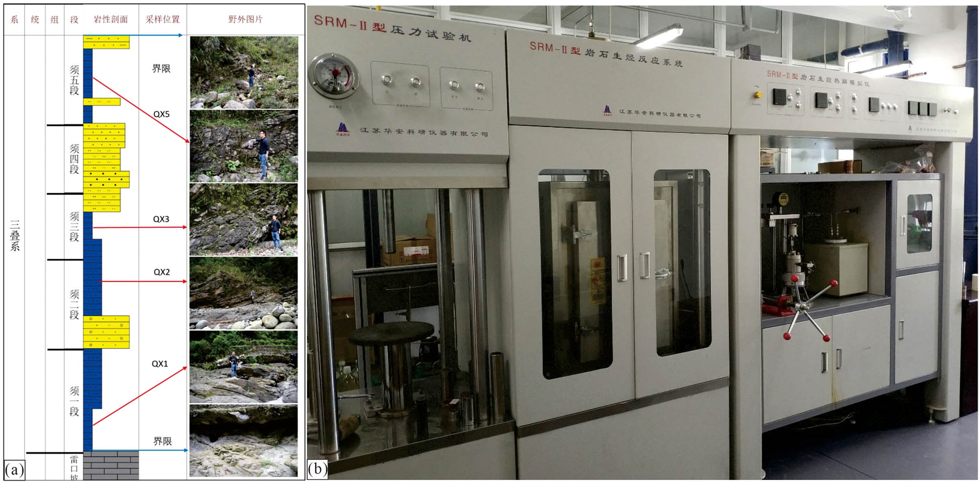
Outcrop location (a) and hydrocarbon-generating thermal simulator (b).
Geochemical characteristics of low-matured source rocks in the Xujiahe outcrop
| Lithology | Formation | TOC (%) | T max (°C) | S1 (mg/g) | S2 (mg/g) | HI (mg/g) | Ro (%) | Kerogen maceral content (%) | TI values | Type | |||
|---|---|---|---|---|---|---|---|---|---|---|---|---|---|
| Liptinite | Exinite | Vitrinite | Inertinite | ||||||||||
| Mudstone | T3x1 | 1.98 | 439 | 0.20 | 1.78 | 90.10 | 0.70 | 55 | — | 16 | 29 | 14 | II2 |
| Mudstone | T3x3 | 2.42 | 435 | 0.24 | 2.17 | 89.67 | 0.68 | 33 | — | 23 | 44 | −28.25 | III |
| Mudstone | T3x5 | 2.46 | 435 | 0.16 | 1.89 | 76.83 | 0.65 | 21 | — | 31 | 48 | −50.25 | III |
Xujiahe source rocks were crushed to 40–60 mesh before the organic geochemical experiment. The powdered samples were then put in a Soxhlet extractor and extracted with chloroform asphalt “A” for 3 days. The final extract was concentrated in a rotary evaporator and dissolved in n-hexane, and the supernatant was obtained after centrifuging in a centrifuge for 5 min and separated on a silica gel/alumina (3:2) column. Then, 30 mL n-hexane was slowly dropped into the column to obtain the transparent liquid as the saturated hydrocarbon. The saturated hydrocarbons were vaporized at the Agilent 7000A GC-mass spectrometer inlet and carried to the column by the carrier gas. Then, the saturated hydrocarbon of each component was separated in the chromatographic column according to its adsorption capacity, and its content was determined by a hydrogen flame detector. Finally, each component entered the mass spectrometer and was bombarded with an ion source to obtain the content of the corresponding biomarker compound, and the ratio of the geochemical parameters of each sample was calculated according to the peak area in the qualitative analysis software.
The collected samples were powdered into 80 mesh and extracted by chloroform asphalt “A” for 48 h until source rocks became colorless, and then dried in the drying box for 12 h before the thermal simulation. The quantitative characteristics of hydrocarbons in the Xujiahe source rocks were measured by the SRM-II hydrocarbon-generation and expulsion pyrolysis simulator under a closed system at Southwest Petroleum University (Figure 2b). The formation pressure was set to 60 MPa, and the source rock mass ranged from 10 to 300 mg in the equipment. The source rocks were heated from 310 to 610°C at 20°C/h. A total of 11 test points were measured at 310, 340, 370, 400, 430, 460, 490, 520, 550, 580, and 610°C. The Agilent 7000A GC-MS was used to measure the gas components and isotopes at different temperature points, and the volumes of different components were calculated by the ideal gas equation at different temperature points.
4 Results
4.1 Biomarker characteristics of source rocks
The distribution of n-alkanes is complete in the T3x1 source rocks, with nC15 as the main peak and Pr/Ph less than 1. Pentacyclic triterpenes are the main terpenes with main C30 hopanes, the high gammacerane content and Ts/Tm close to 1, and the C23 content is high in tricyclic terpenes. The main steranes are regular steranes with C27 and C29, with a low content of diasteranes (Figure 3).

Biomarker compounds in Xujiahe source rocks: (a) T3x1, (b) T3x3, (c) T3x5. (A: 4α-methyl, 24-ethylcholestane; B: 4β-methyl, 24-ethylcholestane; 1: 4α, 23S, 24S-dinosteranes; 2: 4α, 23S, 24R-dinosteranes; 3: 4α, 23R, 24R-dinosteranes; 4: 4α, 23R, 24S-dinosteranes; 5: 4β, 23S, 24S-dinosteranes; 6: 4β, 23S, 24R-dinosteranes; 7: 4β, 23R, 24R-dinosteranes; 8: 4β, 23R, 24S-dinosteranes).
The T3x3 source rocks have a complete distribution of n-alkanes, with nC15 as the main peak and Pr/Ph close to 1. Pentacyclic triterpenes are characterized by main C30 hopanes, the medium gammacerane content and Ts/Tm close to 1, and the C20 and C21 content is high in tricyclic terpenes. The regular steranes are featured in C27 and C29, with the medium content of diasteranes (Figure 3).
The T3x5 source rocks have a complete distribution of n-alkanes, with nC15 as the main peak and Pr/Ph larger than 1. Pentacyclic triterpenes are characterized by the main C30 hopanes, the low gammacerane content and Ts/Tm less than 1, and the C21 content is high in tricyclic terpenes. The regular steranes are featured in low C27 and high C29, with a high content of diasteranes (Figure 3).
Dinosterane is also known as 4,23,24-trimethyl cholestane. Dinosterane peaks after C29 steranes, with strong M/Z 213 fragments with 8 isomers [29]. Figure 3 shows that the T3x1 and T3x3 source rocks contain high dinosteranes, whereas the T3x5 source rocks do not develop dinosteranes.
4.2 Carbon isotope characteristics of gaseous hydrocarbons
The carbon isotope is an important index of gas source and gas genesis [2]. The content of various alkane gases is too low to be detected in the early and late hydrocarbon-generating stages, resulting in the loss of corresponding carbon isotopes (Table 2). In general, carbon isotope values of methane, ethane, and propane (δ 13C1, δ 13C2 and δ 13C3) range from −41.89 to −28.57‰, −29.31 to −26.78‰, and −26.89 to −25.37‰, respectively, in the T3x1 gas (Table 2). The T3x3 gas carbon isotopes include δ 13C1 (−41.23 to −26.25‰), δ 13C2 (−24.93 to −22.29‰), and δ 13C3 (−23.78 to −21.31‰) (Table 2). The δ 13C1, δ 13C2, and δ 13C3 values of T3x5 gas range from −40.11 to −24.13‰, −24.67 to −21.07‰, and −23.16 to −22.22‰, respectively (Table 2). In short, carbon isotopes of T3x1 gas are lighter than those of T3x3 and T3x5 gases and carbon isotopes of T3x5 gas are heavier than those of T3x3 gas.
Geochemical characteristics of the Xujiahe simulated gas
| Formation | Temperature (°C) | δ 13C (‰) | ||
|---|---|---|---|---|
| CH4 | C2H6 | C3H8 | ||
| T3x1 | 310 | — | — | — |
| 340 | −39.29 | — | — | |
| 370 | −40.67 | — | — | |
| 400 | −41.89 | — | — | |
| 430 | −37.57 | −29.31 | −26.89 | |
| 460 | −34.81 | −28.27 | −26.45 | |
| 490 | −34.03 | −27.36 | −25.86 | |
| 520 | −33.16 | −26.78 | −25.37 | |
| 550 | −32.12 | — | — | |
| 580 | −30.69 | — | — | |
| 610 | −28.57 | — | — | |
| T3x3 | 310 | — | — | — |
| 340 | −39.75 | — | — | |
| 370 | −40.58 | — | — | |
| 400 | −41.23 | — | — | |
| 430 | −37.33 | −24.93 | −23.78 | |
| 460 | −35.35 | −24.32 | −22.85 | |
| 490 | −33.83 | −23.52 | −21.79 | |
| 520 | −32.47 | −22.49 | −21.31 | |
| 550 | −30.56 | — | — | |
| 580 | −28.66 | — | — | |
| 610 | −26.25 | — | — | |
| T3x5 | 310 | — | — | — |
| 340 | −38.7 | — | — | |
| 370 | −39.62 | — | — | |
| 400 | −40.11 | — | — | |
| 430 | −37.77 | −24.67 | −23.16 | |
| 460 | −35.05 | −24.1 | −22.63 | |
| 490 | −33.87 | −22.87 | −21.46 | |
| 520 | −32.14 | −21.07 | −21.22 | |
| 550 | −29.07 | — | — | |
| 580 | −27.14 | — | — | |
| 610 | −24.13 | — | — | |
The carbon isotopes of different alkane gases show the carbon isotope characteristics of organic gas with a positive carbon number series. The carbon isotopes of gas hydrocarbon products show different distribution patterns in Xujiahe source rocks (Figure 4a–c). The δ 13C1 values decrease first and then increase with increased maturity. In contrast, the δ 13C2 and δ 13C3 values increase with maturity, and the increased ratio of the δ 13C2 value is larger than that of the δ 13C3 values (Table 2).

Carbon isotope curves of Xujiahe gas hydrocarbons and organic matter type distribution: (a) T3x1, (b) T3x3, (c) T3x5, and (d) the distribution of δ 13C2 and organic matter type.
5 Discussion
5.1 Sedimentary environments of source rocks
The identification of the Xujiahe continuous sedimentary environments is closely related to the quantitative hydrocarbon-generating characteristics, and biomarkers are commonly used in the study of the evolution of transitional, continental, and marine sedimentary environments [30]. The ratio of pristane (Pr) to phytane (Ph) in alkanes is often used to reflect the sedimentary environments of source rocks. The Pr/Ph less than 1 reflects in the marine sedimentary environment, and the Pr/Ph more than 2 reflects in the swamp sedimentary environment [1]. The gammacerane in pentacyclic triterpenes is mainly derived from tetra-hymenium alcohol, which mainly represents the saline sedimentary environment [31]. Moreover, C21 and C23 tricyclic terpenes are also used to characterize the environment. C21 tricyclic terpenes are mainly presented in freshwater sediments and C23 tricyclic terpenes in saline sediments [30,32,33]. Moreover, dinosteranes are biomarkers in the marine environment [34,35].
The Pr/Ph values lower than 0.8 in the T3x1 source rocks indicate that T3x1 source rocks are characterized by marine sediments with high reductive water. The Pr/Ph values higher than 1 in the T3x3 and T3x5 source rocks indicate that the water is in a weak oxidated environment. The gammacerane content decreases from T3x1 to T3x5 source rocks, suggesting the body salinity decreases.
Dinosteranes developed when the Paleo-Tethys Ocean was connected to the T3x1 and T3x3 water, while dinosteranes did not develop in the T3x5 source rocks during the stable period of continental deposition, which also proves that algae substances were abundant during the T3x1 and T3x3 sedimentary period (Figure 3) [7].
Briefly, the T3x1 and T3x3 source rocks are mainly characterized by the transitional sedimentary environment, and the T3x5 source rocks are primarily featured in the continental sedimentary environment. During the sedimentary period from T3x1 to T3x5, water becomes less salty, the oxygen content gradually increases, the reducibility decreases, and the content of algae substances decreases, leading to II2 OM of T3x1 source rocks and III OM of T3x3 and T3x5 source rocks.
5.2 Carbon isotopes of alkane gas
The Xujiahe source rocks have a high content of soluble OM owing to the transformation of terrestrial OM by bacteria and algae, and the strong adsorb ability of coal-bearing OM and aromatic-rich products produced by itself makes these petroleum-like substances remain more in coal-bearing source rocks. When the coal-bearing source rocks experience higher thermal evolution, these substances can be used as high-quality parent material for cracking gas, leading to the decrease in gas carbon isotope values. Section 5.1 points out that the different sedimentary environments of Xujiahe source rocks lead to distinct bacteria and algae content. Moreover, the decrease in bacterial and algal substances from T3x1 to T3x5 source rocks leads to an increase in carbon isotope values of alkane gas produced by source rocks (Table 2).
5.2.1 Carbon isotopes of ethane and OM types
The δ 13C2 values become heavier with increased maturity, whereas this linear change is less sensitive to maturity (Figure 4a–c). Previous scholars often used δ 13C2 values to identify kerogen types. The kerogen of oil-type gas is lighter, while the kerogen of humic gas is heavier [38,39]. According to the results of the hydrocarbon-generating thermal simulation, the δ 13C2 values correspond to the type of source rocks. The δ 13C2 values produced by T3x1 mixed source rocks are relatively light, whereas T3x3 and T3x5 humic source rocks produce relatively heavier δ 13C2 values (Table 2).
The amount of hydrocarbon produced by source rocks is not enough to detect the ethane content in the early stage of low maturity and the early stage of maturity, based on the limitation of the hydrocarbon-generating thermal simulation experiment. Even if the corresponding ethane content can be detected, the accuracy of the experimental analysis results will be affected due to the low ethane content. The δ 13C2 distribution law cannot be judged due to their relatively low ethane content in the over-matured stage. Moreover, ethane will be decomposed into methane in the over-matured stage with a low ethane content, resulting in a large δ 13C2 measurement error. Therefore, the δ 13C2 content in the late maturity to the high maturity stage can accurately reflect the carbon isotope distribution characteristics of source rocks in the thermal simulation experiment.
The δ 13C2 values of T3x1, T3x3, and T3x5 source rocks differ significantly in the late maturity to the high maturity stage, according to the experimental results. The δ 13C2 values of T3x3 and T3x5 source rocks range from −24.93 to −21.07‰, whereas δ 13C2 values of T3x1 source rocks are between −29.31 and −26.78‰ (Table 2 and Figure 4d). Furthermore, the δ 13C2 values range from −24.93 to −21.07‰ when the OM is typed III, ranging from −29.31 to −26.78‰ in the II2 OM. Therefore, the parent material types of natural gas can be distinguished according to the δ 13C2 values of natural gas, which lays a foundation for the comparative study of gas sources.
5.2.2 Quantitative relationship between methane carbon isotopes and maturity
The δ 13C1 values from mixed and humic gases decrease at 340–400°C with the lowest values ranging from −41.89 to −40.11‰ (Table 2). Moreover, it cannot determine trends of ethane and propane carbon isotopes due to the low content of ethane and propane gases (Table 2). The decrease of δ 13C1 values in the early maturity stage of source rocks has been found by many scholars in marine source rocks [2,40]. Furthermore, the δ 13C1 values decrease first and then increase under closed, semi-closed, or open systems [3,12]. He et al. [41] believed that the essential reason for the early decrease of δ 13C2 content was that the early heteroatoms of kerogen were more likely to enrich δ 12C content and fell off more easily, resulting in the high δ 12C and low δ 13C values. Tang et al. [42] and Zhang et al. [43] proposed that the difference between δ 12C and low δ 13C caused the δ 13C1 anomalies by n-octadecane thermal simulation experiments. Briefly, it is common for the δ 13C1 content to decrease in the early-matured stage owing to the complex and heterogeneous kerogen structure and differential fractionation of carbon isotopes. It can be deduced that ethane and propane should have a similar distribution, but the precision of the instrument temporarily hindered the study. Therefore, the δ 13C1 variation is universal in the Xujiahe source rocks.
The δ 13C1 content has a certain linear relationship with the maturity, which can be used to reflect the thermal maturity stage of natural gas formation and judge gas source. Moreover, previous scholars established the empirical formulas for humic gas, oil-type gas, and mixed gas based on the δ 13C1 statistical data in the different basins [44,45]. However, the regression equation of δ 13C and Ro has some errors when determining the gas source accurately owing to the OM components, thermal evolution degree, and limited statistical data of source rocks. Therefore, the regression equation of δ 13C and Ro was established in the mixed and humic gases by thermal simulation experiment (Figure 5) as follows:

Relationship between δ 13C1 and Ro in different types of natural gas: (a) mixed gas and (b) humic gas.
The results show that the fitting coefficients of the linear equation of mixed and humic gases are high in the matured to over-matured stage, indicating the validity of the regression equation. However, some errors occur in judging the thermal maturity at the early-matured stage owing to the complex origin of early abnormal δ 13C1.
5.2.3 Carbon isotope inversion
The natural gas δ 13C2 and δ 13C3 values of T3x5 source rocks show slight inversion at 500°C in the late stage of high maturity (Table 2). The carbon isotopes of organic gas show positive carbon isotope distribution, meaning that the carbon isotopes of alkanes become heavier with increased carbon numbers [1]. However, carbon isotope anomalies (e.g., negative carbon isotope series and carbon isotope inversion), have been found in the high-matured to over-matured stage of natural gas globally, which shows that the carbon isotope inversion of natural gas is not an experimental error, but exists in the evolution of source rocks [40,46]. He et al. [47] and Gao et al. [3] also found ethane carbon isotope inversion in thermal simulation experiments. Many scholars found carbon isotope inversion of natural gas in the study of humic and oil-type gases [38,48,49]. All these studies indicate that carbon isotope inversion is a normal phenomenon at the high-matured or over-matured stage.
The causes of carbon isotope inversion mainly include the formation of alkane gases with reconstituted light carbon isotopes and the mixing of primary kerogen and retained hydrocarbon-cracking gas [40]. It is questionable that the alkane gas that recombines hydrogen and carbon dioxide to form light carbon isotopes causes the carbon isotope inversion of heavy hydrocarbon gas, because of sufficient catalysts. More evidence are needed on whether sufficient catalysts occur in realistic geological conditions. Moreover, the carbon isotope inversion of natural gas cannot be produced in the later stage, if the retained hydrocarbon is cracked into gas in the early-matured stage. These studies do not explain the formation of carbon isotope inversion. Peng et al. [4] found that the light carbon isotopes of heavy hydrocarbons formed by methyl recombination were an important reason for the abnormal carbon isotopes of heavy hydrocarbons in the high thermal evolution stage through the study of coal samples. This research result also explains the reason for carbon isotope inversion in coal-bearing source rocks. However, carbon isotope inversion occurs at 550°C in coal samples, whereas carbon isotopes reverse at 520°C in coal-bearing source rocks. This difference may be caused by the distinct OM components between coal samples and coal-bearing source rocks.
6 Conclusions
The distinguishable hydrocarbon gases are developed with different OMs of source rocks in the Xujiahe continuous sedimentary environment.
The T3x1 and T3x3 source rocks are primarily characterized by the transitional sedimentary environment, and the T3x5 source rocks are primarily featured in the continental sedimentary environment. The bacteria and algae decreased from T3x1 to T3x5 source rocks, and its corresponding carbon isotope values of alkanes increased successively, leading to the II2 OM in the T3x1 source rocks and the III OM in the T3x3 and T3x5 source rocks.
The δ 13C1 values decrease first and then increase. The quantitative relationship is presented at δ 13C1 = 12.21 ln Ro – 39.72 (humic gas) and δ 13C1 = 8.07 ln Ro – 38.3 (mixed gas). The δ 13C2 values range from −24.93 to −21.07‰ in the T3x1 and T3x3 source rocks, ranging from −29.31 to −26.78‰ in the T3x5 source rocks, which can effectively distinguish the OM types by δ 13C2 values. The lighter heavy hydrocarbon carbon isotopes formed by the methyl recombination lead to the abnormal carbon isotopes of heavy hydrocarbons in the high thermal evolution stage.
Acknowledgements
The authors declare that they have no financial and personal relationships with other people or organizations that can inappropriately influence their work, there is no professional or other personal interest of any nature or kind in any product, service, and/or company that could be construed as influencing the position presented in, or the review of, the manuscript entitled “Hydrocarbon-generating characteristics of Xujiahe coal-bearing source rocks in the continuous sedimentary environment of the Southwest Sichuan.”
-
Funding information: The article is supported by the funding of “Natural Science Foundation of China (42072185).”
-
Author contributions: Tao Yang: Conceptualization. Kun Xu: Writing original draft, software, experiment. Jungang Lu: Data processing, data curation methodology. Bai Liu: Investigation. Jianbo Liao: Writing, reviewing and editing.
-
Conflict of interest: Authors state no conflict of interest.
-
Data availability statement: The data that support the findings of this study are available from the corresponding author.
References
[1] Tissot B, Durand B. Influence of natures and diagenesis of organic matter in formation of petroleum. AAPG Bull. 1974;58:499–506.10.1306/83D91425-16C7-11D7-8645000102C1865DSearch in Google Scholar
[2] Tian H, Xiao X, Li X, Xiao Z, Liu D. Comparison of gas generation and carbon isotope fraction of methane from marine kerogen and crude oil-cracking gaes. Geochimica. 2007;36(1):71–7.Search in Google Scholar
[3] Gao J, Liu J, Ni Y. Gas generation and its isotope composition during coal pyrolysis: the catalytic effect of nickel and magnetite. Fuel. 2018;222:74–82.10.1016/j.fuel.2018.02.118Search in Google Scholar
[4] Peng W, Liu Q, Hu G, Lyu Y, Zhu D, Meng Q, et al. Mechanisms of carbon isotope fractionation in the process of natural gas generation. Geochem Evid Therm Simul Exp. 2020;47(5):972–83.10.1016/S1876-3804(20)60115-XSearch in Google Scholar
[5] Wang Z, Hao C, Jin H, Jin H, Cui J, Wu X, et al. Geochemical characteristics and hydrocarbon generation potential of main source rocks in the Upper Triassic Xujiahe Formation, Sichuan Basin, China. Front Earth Sci. 2023;11:1233959.10.3389/feart.2023.1276359Search in Google Scholar
[6] Tang L, Song Y, Pang X, Jiang Z, Guo Y, Zhang H, et al. Effects of paleo sedimentary environment in saline lacustrine basin on organic matter accumulation and preservation: a case study from the Dongpu Depression, Bohai Bay Basin, China. J Pet Sci Eng. 2019;185(3):106669.10.1016/j.petrol.2019.106669Search in Google Scholar
[7] Xu K, Chen S, Lu J, Li Y, Zhu X, Liu J, et al. Palaeosedimentary environment and formation mechanism of high-quality Xujiahe source rocks, Sichuan Basin, South China. Lithosphere. 2022;2022(Special 13):7185107.10.2113/2022/7185107Search in Google Scholar
[8] Hezarkhani A, Ghannadpour SS. Geochemical behavior investigation based on K-means clustering (basics, concepts and case study). 1st edn. Germany: LAP LAMBERT Academic Publishing; 2015.Search in Google Scholar
[9] Ghannadpour SS, Hezarkhani A. Investigation of Cu, Mo, Pb, and Zn geochemical behavior and geological interpretations for Parkam porphyry copper system, Kerman, Iran. Arab J Geosciencesm. 2015;8(9):7273–84.10.1007/s12517-014-1732-0Search in Google Scholar
[10] Ghannadpour SS, Hezarkhani A, Sabetmobarhan A. Some statistical analyses of Cu and Mo variates and geological interpretations for Parkam porphyry copper system, Kerman, Iran. Arab J Geosci. 2015;8(1):345–55.10.1007/s12517-013-1096-xSearch in Google Scholar
[11] Ghannadpour SS, Hezarkhani A, Roodpeyma T. Combination of separation methods and data mining techniques for prediction of anomalous areas in Susanvar, Central Iran. Afr J Earth Sci. 2017;134:516–25.10.1016/j.jafrearsci.2017.07.015Search in Google Scholar
[12] Xiao Z, Hu G, Li Z. An analysis of characteristics of hydrocarbon generation from pyrolysis experiment of source rock. Nat Gas Geosci. 2008;19(4):544–7.Search in Google Scholar
[13] Wang YP, Zou YR, Zhan ZW, Lin XH, Liang T. Origin of natural gas in the Turpan-Hami Basin, NW China: evidence from pyrolytic simulation experiment. Int J Coal Geol. 2018;195:238–49.10.1016/j.coal.2018.06.007Search in Google Scholar
[14] Pang X, Zheng T, Ma X, Zheng D, Wang W, Wang X, et al. Hydrocarbon generation and expulsion features of the Upper Triassic Xujiahe Formation source rocks and their controlling effects on hydrocarbon accumulation in the Sichuan Basin, Central China. Geol J. 2020;55(7):4977–96.10.1002/gj.3653Search in Google Scholar
[15] Wu Z, Li T, Ji S, Zhou Q, Tian H. Gas generation from coal and coal-measure mudstone source rocks of the Xujiahe formation in the Western Sichuan depression, Sichuan basin. J Earth Sci. 2023;34(4):1012–25.10.1007/s12583-022-1627-zSearch in Google Scholar
[16] Wang L, Zhao H, Wu L, Jun T. Geochemical characteristics of hydrocarbon source rock of the member 3 of Xujiahe formation in the south area of Langzhong, Sichuan, China. J Chengdu Univ Technol (Sci Technol Ed). 2020;47(2):169–77.Search in Google Scholar
[17] Zheng H, Liu Z, Xu S, Liu Z, Liu J, Huang Z, et al. Progress and key research directions of tight gas exploration and development in Xujiahe Formation, Sinopec exploration areas, Sichuan basin. Pet gas Geol. 2021;42(4):765–83.Search in Google Scholar
[18] Mu H, Yan DP, Qiu L, Yang WX, Kong RY, Gong LX, et al. Formation of the Late Triassic western Sichuan foreland basin of the Qinling Orogenic Belt, SW China: sedimentary and geochronological constraints from the Xujiahe Formation. J Asian Earth Sci. 2019;183:1–20.10.1016/j.jseaes.2019.103938Search in Google Scholar
[19] Gou M, Lu G, Deng B, Wang C, Li Z, Yu Y, et al. Tectonic-paleogeographic evolution of the Late Triassic in the Sichuan basin, SW China: constraints from sedimentary facies and provenance analysis of the Xujiahe formation. Mar Pet Geol. 2024;160:106649.10.1016/j.marpetgeo.2023.106649Search in Google Scholar
[20] Xie X, Li S, Lu N, Wang Y, Xi S. Sedimentary facies and sedimentary environment evolution of first member of the Xujiahe formation in Guangyuan area, Northern Sichuan Province. Acta Sedimentol Sin. 2021;39(2):493–505.Search in Google Scholar
[21] Jin W, Wang Z. Discussion on marine facies and beach bar—lagoon system of Xujiahe formation in Sichuan basin. IOP Conf Ser Earth Environ Sci. 2021;766(1):012072.10.1088/1755-1315/766/1/012072Search in Google Scholar
[22] Zhao X, Zhang W. A re-discussion on the origins of tidal deposits in the Xujiahe Formation of the Sichuan Basin: further evidences and sequence analysis. Nat Gas Ind. 2011;31(9):25–30.Search in Google Scholar
[23] Wu X, Chen Y, Zhao G, Du X, Zeng H, Wang P, et al. The Upper Triassic Xujiahe formation in the Xinchang gasfield, the Western Sichuan depression, Sichuan basin. Nat Gas Geosci. 2017;28(11):1714–22.Search in Google Scholar
[24] Luo Q. Discovery of water-transgression cause filling sands-bodies in ancient sediments – an approach to the genesis of certain upper Triassic sand-bodies in the middle-western part of the Sichuan Basin and discussion on water-transgression delta. Acta Sedimentol Sin. 1983;1(3):59–68.Search in Google Scholar
[25] Zhao X, Lv Z, Zhang W, Peng H, Kang R. Paralic tidal deposits in the upper Triassic Xujiahe formation in Anyue area, the Sichuan basin. Nat Gas Ind. 2008;28(4):14–8.Search in Google Scholar
[26] Wang Z, Shi Y, Wen L, Jiang H, Jiang Q, Huang S, et al. Exploring the potential of oil and gas resources in Sichuan Basin with Super Basin Thinking. Pet Explor Dev. 2022;49(5):977–90.10.1016/S1876-3804(22)60326-4Search in Google Scholar
[27] Bo S, Tian J, Wang Y, Fu S, Kan H, Sun G. Sedimentary environment evolution of marine-continental transitional facies in Xujiahe Formation, northeastern Sichuan Basin: evidence from element geochemistry. Nat Gas Geosci. 2024;35(4):645–60.Search in Google Scholar
[28] Meng Q. Origin of the Qinling mountains (in Chinese). Sci Sin Terrae. 2017;47:412–20.10.1360/N072016-00422Search in Google Scholar
[29] Ma J, Ma Z, Miao J, Zheng L, Wang Q, He C. Co⁃evolution simulation experiment of source rock fluid and reservoir rock and its geological implications: a case study of Upper Triassic Xujiahe formation, Western Sichuan basin. Pet Geol Exp. 2022;44(4):698–704.Search in Google Scholar
[30] Burger K, Zhou Y, Ren Y. Petrography and geochemistry of tonsteins from the 4th Member of the Upper Triassic Xujiahe formation in southern Sichuan Province, China. Int J Coal Geol. 2002;49(1):1–17.10.1016/S0166-5162(01)00053-2Search in Google Scholar
[31] Dai J, Ni Y, Zou C. Stable carbon isotopes of alkane gases from the Xujiahe coal measures and implication for gas-source correlation in the Sichuan Basin, SW China. Org Geochem. 2009;40(5):638–46.10.1016/j.orggeochem.2009.01.012Search in Google Scholar
[32] Hou D, Wang T, Zhang Y. Dinosteranes in the Tertiary terrestrial deposits, eastern China – the marker of marine transgression facies? Geol Rev. 1997;43(5):524–8.Search in Google Scholar
[33] Zhenglu X, Shijia C, Yong L, Kaiming S, Qingbo H, Meimei H. Local high-salinity source rock and origin of crude oil in the Xianshuiquan structure in the northwestern Qaidam Basin, China. J Pet Sci Eng. 2021;198:108233.10.1016/j.petrol.2020.108233Search in Google Scholar
[34] Lu J, Luo Z, Zou H, Li Y, Hu Z, Zhou Z, et al. Geochemical characteristics, origin, and mechanism of differential accumulation of natural gas in the carboniferous kelameili gas field in Junggar basin, China. J Pet Sci Eng. 2021;203:108658.10.1016/j.petrol.2021.108658Search in Google Scholar
[35] Luo Y, Zhang M. Distribution characteristics and main controlling factors of high carbon number tricyclic terpenes in Lishu fault depression of Songliao Basin. Acta Sedimentol Sin. 2023;41(2):1–20.Search in Google Scholar
[36] Liu Z, Liu X, Li P. Mineralization on tests made by algae and its organic matters. Acta Sedimentol Sin. 1999;1999(1):9–18.Search in Google Scholar
[37] Hui R, Ding A. Generation of petroleum and natural gas in the transformation of organic. Acta Sedimentol Sin. 2019;37(2):424–31.Search in Google Scholar
[38] Dai J, Zou C, Dong D, Ni Y, Wu W, Gong D, et al. Geochemical characteristics of marine and terrestrial shale gas in China. Mar Pet Geol. 2006;76:444–63.10.1016/j.marpetgeo.2016.04.027Search in Google Scholar
[39] Xu K, Chen S, Liu C, Liu Z, Li C. Geochemical characteristics of source rocks and natural gas in Fudong area, Junggar Basin: implications for the genesis of natural gas. Arab J Geosci. 2022;15:544.10.1007/s12517-022-09820-xSearch in Google Scholar
[40] Zumberge J, Ferworn K, Brown S. Isotopic reversal (‘rollover’) in shale gases produced from the Mississippian Barnett and Fayetteville formations. Mar Pet Geol. 2012;31(1):43–52.10.1016/j.marpetgeo.2011.06.009Search in Google Scholar
[41] He K, Zhang S, Mi J, Zhang W. Pyrolysis involving n-hexadecane, water and minerals: insight into the mechanisms and isotope fractionation for water-hydrocarbon reaction. J Anal Appl Pyrolysis. 2018;130:198–208.10.1016/j.jaap.2018.01.009Search in Google Scholar
[42] Tang Y, Perry JK, Jenden PD, Schoell M. Mathematical modeling of stable carbon isotope ratios in natural gases. Geochim Cosmochim Acta. 2000;64(15):2673–87.10.1016/S0016-7037(00)00377-XSearch in Google Scholar
[43] Zhang H, Geng A, Xiong Y, Liu J, Geng X, Liu J, et al. Pyrolysis kinetics of pure n-C18H38 (I): gaseous hydrocarbon and carbon isotope evolution. Acta Geol Sin. 2005;79(4):569–74.Search in Google Scholar
[44] Dai J, Qi H. δ13C–Ro relationship of coal-derived hydrocarbon gases in China. Chin Sci Bull. 1989;9:690.Search in Google Scholar
[45] Berner U, Faber E. Empirical carbon isotope/maturity relationships for gases from algal kerogens and terrigenous organic matter, based on dry, open-system pyrolysis. Org Geochem. 1996;24(10):947–55.10.1016/S0146-6380(96)00090-3Search in Google Scholar
[46] Tilley B, Mclellan S, Hiebert S, Quartero B, Veilleux B, Muehlenbachs K. Gas isotope reversals in fractured gas reservoirs of the western Canadian Foothills: mature shale gases disguise. AAPG Bull. 2011;95(8):1399–422.10.1306/01031110103Search in Google Scholar
[47] He K, Zhang S, Mi J, Zhang W. The evolution of chemical groups and isotopic fractionation at different maturation stages during lignite pyrolysis. Fuel. 2018;211:492–506.10.1016/j.fuel.2017.09.085Search in Google Scholar
[48] Xia X, Chen J, Braun R. Isotopic reversals with respect to maturity trends due to mixing of primary and secondary products in source rocks. Chem Geol. 2013;339:205–12.10.1016/j.chemgeo.2012.07.025Search in Google Scholar
[49] Li J, Li J, Li Z, Wang D, Gong S, Zhang Y, et al. The hydrogen isotopic characteristics of the Upper Paleozoic natural gas in Ordos Basin. Org Geochem. 2014;74:66–75.10.1016/j.orggeochem.2014.01.020Search in Google Scholar
© 2025 the author(s), published by De Gruyter
This work is licensed under the Creative Commons Attribution 4.0 International License.
Articles in the same Issue
- Research Articles
- Seismic response and damage model analysis of rocky slopes with weak interlayers
- Multi-scenario simulation and eco-environmental effect analysis of “Production–Living–Ecological space” based on PLUS model: A case study of Anyang City
- Remote sensing estimation of chlorophyll content in rape leaves in Weibei dryland region of China
- GIS-based frequency ratio and Shannon entropy modeling for landslide susceptibility mapping: A case study in Kundah Taluk, Nilgiris District, India
- Natural gas origin and accumulation of the Changxing–Feixianguan Formation in the Puguang area, China
- Spatial variations of shear-wave velocity anomaly derived from Love wave ambient noise seismic tomography along Lembang Fault (West Java, Indonesia)
- Evaluation of cumulative rainfall and rainfall event–duration threshold based on triggering and non-triggering rainfalls: Northern Thailand case
- Pixel and region-oriented classification of Sentinel-2 imagery to assess LULC dynamics and their climate impact in Nowshera, Pakistan
- The use of radar-optical remote sensing data and geographic information system–analytical hierarchy process–multicriteria decision analysis techniques for revealing groundwater recharge prospective zones in arid-semi arid lands
- Effect of pore throats on the reservoir quality of tight sandstone: A case study of the Yanchang Formation in the Zhidan area, Ordos Basin
- Hydroelectric simulation of the phreatic water response of mining cracked soil based on microbial solidification
- Spatial-temporal evolution of habitat quality in tropical monsoon climate region based on “pattern–process–quality” – a case study of Cambodia
- Early Permian to Middle Triassic Formation petroleum potentials of Sydney Basin, Australia: A geochemical analysis
- Micro-mechanism analysis of Zhongchuan loess liquefaction disaster induced by Jishishan M6.2 earthquake in 2023
- Prediction method of S-wave velocities in tight sandstone reservoirs – a case study of CO2 geological storage area in Ordos Basin
- Ecological restoration in valley area of semiarid region damaged by shallow buried coal seam mining
- Hydrocarbon-generating characteristics of Xujiahe coal-bearing source rocks in the continuous sedimentary environment of the Southwest Sichuan
- Hazard analysis of future surface displacements on active faults based on the recurrence interval of strong earthquakes
- Structural characterization of the Zalm district, West Saudi Arabia, using aeromagnetic data: An approach for gold mineral exploration
- Research on the variation in the Shields curve of silt initiation
- Reuse of agricultural drainage water and wastewater for crop irrigation in southeastern Algeria
- Assessing the effectiveness of utilizing low-cost inertial measurement unit sensors for producing as-built plans
- Analysis of the formation process of a natural fertilizer in the loess area
- Machine learning methods for landslide mapping studies: A comparative study of SVM and RF algorithms in the Oued Aoulai watershed (Morocco)
- Chemical dissolution and the source of salt efflorescence in weathering of sandstone cultural relics
- Molecular simulation of methane adsorption capacity in transitional shale – a case study of Longtan Formation shale in Southern Sichuan Basin, SW China
- Evolution characteristics of extreme maximum temperature events in Central China and adaptation strategies under different future warming scenarios
- Estimating Bowen ratio in local environment based on satellite imagery
- 3D fusion modeling of multi-scale geological structures based on subdivision-NURBS surfaces and stratigraphic sequence formalization
- Comparative analysis of machine learning algorithms in Google Earth Engine for urban land use dynamics in rapidly urbanizing South Asian cities
- Study on the mechanism of plant root influence on soil properties in expansive soil areas
- Simulation of seismic hazard parameters and earthquakes source mechanisms along the Red Sea rift, western Saudi Arabia
- Tectonics vs sedimentation in foredeep basins: A tale from the Oligo-Miocene Monte Falterona Formation (Northern Apennines, Italy)
- Investigation of landslide areas in Tokat-Almus road between Bakımlı-Almus by the PS-InSAR method (Türkiye)
- Predicting coastal variations in non-storm conditions with machine learning
- Cross-dimensional adaptivity research on a 3D earth observation data cube model
- Geochronology and geochemistry of late Paleozoic volcanic rocks in eastern Inner Mongolia and their geological significance
- Spatial and temporal evolution of land use and habitat quality in arid regions – a case of Northwest China
- Ground-penetrating radar imaging of subsurface karst features controlling water leakage across Wadi Namar dam, south Riyadh, Saudi Arabia
- Rayleigh wave dispersion inversion via modified sine cosine algorithm: Application to Hangzhou, China passive surface wave data
- Fractal insights into permeability control by pore structure in tight sandstone reservoirs, Heshui area, Ordos Basin
- Debris flow hazard characteristic and mitigation in Yusitong Gully, Hengduan Mountainous Region
- Research on community characteristics of vegetation restoration in hilly power engineering based on multi temporal remote sensing technology
- Identification of radial drainage networks based on topographic and geometric features
- Trace elements and melt inclusion in zircon within the Qunji porphyry Cu deposit: Application to the metallogenic potential of the reduced magma-hydrothermal system
- Pore, fracture characteristics and diagenetic evolution of medium-maturity marine shales from the Silurian Longmaxi Formation, NE Sichuan Basin, China
- Study of the earthquakes source parameters, site response, and path attenuation using P and S-waves spectral inversion, Aswan region, south Egypt
- Source of contamination and assessment of potential health risks of potentially toxic metal(loid)s in agricultural soil from Al Lith, Saudi Arabia
- Regional spatiotemporal evolution and influencing factors of rural construction areas in the Nanxi River Basin via GIS
- An efficient network for object detection in scale-imbalanced remote sensing images
- Effect of microscopic pore–throat structure heterogeneity on waterflooding seepage characteristics of tight sandstone reservoirs
- Environmental health risk assessment of Zn, Cd, Pb, Fe, and Co in coastal sediments of the southeastern Gulf of Aqaba
- A modified Hoek–Brown model considering softening effects and its applications
- Evaluation of engineering properties of soil for sustainable urban development
- The spatio-temporal characteristics and influencing factors of sustainable development in China’s provincial areas
- Application of a mixed additive and multiplicative random error model to generate DTM products from LiDAR data
- Gold vein mineralogy and oxygen isotopes of Wadi Abu Khusheiba, Jordan
- Prediction of surface deformation time series in closed mines based on LSTM and optimization algorithms
- 2D–3D Geological features collaborative identification of surrounding rock structural planes in hydraulic adit based on OC-AINet
- Spatiotemporal patterns and drivers of Chl-a in Chinese lakes between 1986 and 2023
- Land use classification through fusion of remote sensing images and multi-source data
- Nexus between renewable energy, technological innovation, and carbon dioxide emissions in Saudi Arabia
- Analysis of the spillover effects of green organic transformation on sustainable development in ethnic regions’ agriculture and animal husbandry
- Factors impacting spatial distribution of black and odorous water bodies in Hebei
- Large-scale shaking table tests on the liquefaction and deformation responses of an ultra-deep overburden
- Impacts of climate change and sea-level rise on the coastal geological environment of Quang Nam province, Vietnam
- Reservoir characterization and exploration potential of shale reservoir near denudation area: A case study of Ordovician–Silurian marine shale, China
- Seismic prediction of Permian volcanic rock reservoirs in Southwest Sichuan Basin
- Application of CBERS-04 IRS data to land surface temperature inversion: A case study based on Minqin arid area
- Geological characteristics and prospecting direction of Sanjiaoding gold mine in Saishiteng area
- Research on the deformation prediction model of surrounding rock based on SSA-VMD-GRU
- Geochronology, geochemical characteristics, and tectonic significance of the granites, Menghewula, Southern Great Xing’an range
- Hazard classification of active faults in Yunnan base on probabilistic seismic hazard assessment
- Characteristics analysis of hydrate reservoirs with different geological structures developed by vertical well depressurization
- Estimating the travel distance of channelized rock avalanches using genetic programming method
- Landscape preferences of hikers in Three Parallel Rivers Region and its adjacent regions by content analysis of user-generated photography
- New age constraints of the LGM onset in the Bohemian Forest – Central Europe
- Characteristics of geological evolution based on the multifractal singularity theory: A case study of Heyu granite and Mesozoic tectonics
- Soil water content and longitudinal microbiota distribution in disturbed areas of tower foundations of power transmission and transformation projects
- Oil accumulation process of the Kongdian reservoir in the deep subsag zone of the Cangdong Sag, Bohai Bay Basin, China
- Investigation of velocity profile in rock–ice avalanche by particle image velocimetry measurement
- Optimizing 3D seismic survey geometries using ray tracing and illumination modeling: A case study from Penobscot field
- Sedimentology of the Phra That and Pha Daeng Formations: A preliminary evaluation of geological CO2 storage potential in the Lampang Basin, Thailand
- Improved classification algorithm for hyperspectral remote sensing images based on the hybrid spectral network model
- Map analysis of soil erodibility rates and gully erosion sites in Anambra State, South Eastern Nigeria
- Identification and driving mechanism of land use conflict in China’s South-North transition zone: A case study of Huaihe River Basin
- Evaluation of the impact of land-use change on earthquake risk distribution in different periods: An empirical analysis from Sichuan Province
- A test site case study on the long-term behavior of geotextile tubes
- An experimental investigation into carbon dioxide flooding and rock dissolution in low-permeability reservoirs of the South China Sea
- Detection and semi-quantitative analysis of naphthenic acids in coal and gangue from mining areas in China
- Comparative effects of olivine and sand on KOH-treated clayey soil
- YOLO-MC: An algorithm for early forest fire recognition based on drone image
- Earthquake building damage classification based on full suite of Sentinel-1 features
- Potential landslide detection and influencing factors analysis in the upper Yellow River based on SBAS-InSAR technology
- Assessing green area changes in Najran City, Saudi Arabia (2013–2022) using hybrid deep learning techniques
- An advanced approach integrating methods to estimate hydraulic conductivity of different soil types supported by a machine learning model
- Hybrid methods for land use and land cover classification using remote sensing and combined spectral feature extraction: A case study of Najran City, KSA
- Streamlining digital elevation model construction from historical aerial photographs: The impact of reference elevation data on spatial accuracy
- Analysis of urban expansion patterns in the Yangtze River Delta based on the fusion impervious surfaces dataset
- A metaverse-based visual analysis approach for 3D reservoir models
- Review Articles
- Humic substances influence on the distribution of dissolved iron in seawater: A review of electrochemical methods and other techniques
- Applications of physics-informed neural networks in geosciences: From basic seismology to comprehensive environmental studies
- Ore-controlling structures of granite-related uranium deposits in South China: A review
- Shallow geological structure features in Balikpapan Bay East Kalimantan Province – Indonesia
- A review on the tectonic affinity of microcontinents and evolution of the Proto-Tethys Ocean in Northeastern Tibet
- Special Issue: Natural Resources and Environmental Risks: Towards a Sustainable Future - Part II
- Depopulation in the Visok micro-region: Toward demographic and economic revitalization
- Special Issue: Geospatial and Environmental Dynamics - Part II
- Advancing urban sustainability: Applying GIS technologies to assess SDG indicators – a case study of Podgorica (Montenegro)
- Spatiotemporal and trend analysis of common cancers in men in Central Serbia (1999–2021)
- Minerals for the green agenda, implications, stalemates, and alternatives
- Spatiotemporal water quality analysis of Vrana Lake, Croatia
- Functional transformation of settlements in coal exploitation zones: A case study of the municipality of Stanari in Republic of Srpska (Bosnia and Herzegovina)
- Hypertension in AP Vojvodina (Northern Serbia): A spatio-temporal analysis of patients at the Institute for Cardiovascular Diseases of Vojvodina
- Regional patterns in cause-specific mortality in Montenegro, 1991–2019
- Spatio-temporal analysis of flood events using GIS and remote sensing-based approach in the Ukrina River Basin, Bosnia and Herzegovina
- Flash flood susceptibility mapping using LiDAR-Derived DEM and machine learning algorithms: Ljuboviđa case study, Serbia
- Geocultural heritage as a basis for geotourism development: Banjska Monastery, Zvečan (Serbia)
- Assessment of groundwater potential zones using GIS and AHP techniques – A case study of the zone of influence of Kolubara Mining Basin
- Impact of the agri-geographical transformation of rural settlements on the geospatial dynamics of soil erosion intensity in municipalities of Central Serbia
- Where faith meets geomorphology: The cultural and religious significance of geodiversity explored through geospatial technologies
- Applications of local climate zone classification in European cities: A review of in situ and mobile monitoring methods in urban climate studies