Rock control on evolution of Khorat Cuesta, Khorat UNESCO Geopark, Northeastern Thailand
-
Prachya Tepnarong
 ,
Sirinart Chio-Srichan
,
Sirinart Chio-Srichan

Abstract
The Khorat UNESCO Global Geopark in northeastern Thailand features a distinctive double cuesta landscape, the “Khorat Cuesta,” developed in Mesozoic sandstones of the Phra Wihan, Sao Khua, and Phu Phan Formations. Although the geology of the Khorat Plateau has been extensively studied, the role of rock properties in controlling geomorphological development remains poorly understood. This study investigates the relationships between lithological, physical, chemical, and mechanical properties of sandstones and their influence on cuesta evolution. Field investigations were conducted at eight localities within the Geopark, complemented by laboratory analyses of petrography, X-ray diffraction, density, porosity, uniaxial compressive strength, and slake durability. Geomorphological analysis incorporated geographic information system and remote sensing using 30 m resolution Shuttle Radar Topography Mission data. Results reveal significant lithological variability among the three formations. Phra Wihan and Phu Phan sandstones, though quartz-rich and forming prominent escarpments, display relatively low strength (R2–R4) and degrade rapidly under slake durability testing. In contrast, Sao Khua sandstones, characterized by fine grain size and calcite cementation, exhibit higher strength (R4–R5) and greater resistance to mechanical breakdown, though they remain vulnerable to chemical dissolution. These differences account for contrasting geomorphic expressions: mechanical weathering dominates in the Phra Wihan and Phu Phan Formations, whereas chemical weathering, particularly acid-induced dissolution, plays a key role in the Sao Khua Formation. Contrary to models emphasizing tectonic uplift or mass wasting in other cuesta systems, the Khorat Cuesta is primarily shaped by differential weathering of sedimentary strata with contrasting properties. These findings underscore the importance of lithological control in cuesta evolution and provide new perspectives for geopark evaluation, geoconservation, and geotourism interpretation. By linking rock properties to geomorphic development, this study contributes to understanding landscape evolution in northeastern Thailand and enhances the scientific value of the Khorat Geopark.
Graphical abstract
1 Introduction
Sedimentary tablelands and cuesta landscapes occupy extensive portions of continental surfaces and are often associated with striking scenic vistas. When the stratified rocks lie horizontally, the resulting landforms typically include plateaus bordered by marginal escarpments, stepped tablelands, and assemblages of residual hills; such landscapes are generally referred to as tablelands. By contrast, when strata are tilted, producing gently inclined slopes parallel to the dip direction and steep slopes facing against the dip, the resulting asymmetric terrain is termed a cuesta [1]. These geomorphic features are widespread and occur across many continents, with notable examples including the Colorado Plateau (USA), the High Weald (England), the Tablelands of the Bohemian Cretaceous Basin (Germany and Switzerland), the Stołowe Mountains (Poland), and Queensland (Australia) [1,2,3].
The cuesta is a distinctive landform associated with sedimentary rocks formed through the differential erosion of gently dipping sedimentary sequences. Typically, developing in strata inclined at approximately 5 to less than 15°, cuestas are characterized by a steep slope (escarpment or scarp) on one side, underlain by more resistant beds, and a gentler dip slope on the other, aligned with the dip direction of the strata. Cuesta landscapes have been extensively studied in various regions [2,3,4,5,6,7], revealing diverse factors that influence local geomorphic processes and landform evolution.
Large-scale tablelands and cuestas primarily originate from tectonic activity and are strongly controlled by structural frameworks; however, their long-term evolution is also influenced by weathering and erosional processes [3,6,8]. Studies on the weathering behavior and material properties of both clastic and carbonate rocks demonstrate their crucial role in landform development [8,9,10,11,12,13]. Turkington and Paradise [9] provided a comprehensive review of sandstone weathering, highlighting key research directions and outstanding questions, while Goudie [12] examined techniques for quantifying rock properties and their relevance to geomorphological interpretation. Rock durability has been assessed through laboratory studies of sandstone weathering and rock properties [14,15,16]. Weathering and erosion have also been investigated using physical modeling in the field [17,18,19]. Although the influence of rock properties on geomorphology – particularly in sandstone-dominated landscapes – has been widely investigated in many regions of the world, as mentioned previously, such studies remain comparatively scarce in Southeast Asia, including Thailand.
Landforms constitute a critical criterion in geopark evaluation, as geomorphology elucidates landscape-forming processes and highlights features of geotourism and conservation value [20,21]. In Thailand, two UNESCO Global Geoparks exemplify the country’s diverse landforms and geological histories. The Satun UNESCO Geopark, located in the southern region, is characterized by karst topography and marine sedimentary rocks deposited during the Paleozoic Era [22]. In contrast, the Khorat UNESCO Geopark in the northeastern region shows a distinct cuesta landscape formed from terrestrial deposits of the Mesozoic and Cenozoic Eras [23]. The Khorat Geopark, on the southwestern margin of the Khorat Plateau (Figure 1), spans elevations of 200–1,200 m a.s.l. and features the “Khorat Cuesta,” a double cuesta system with resistant strata forming cliffs and a weaker unit forming the intervening valley (Figure 2a and b). These striking geological features not only create dramatic landscapes that appeal to tourists but also support vital ecological functions. The mountainous terrain provides habitats for a diverse array of flora and fauna and serves as a critical hydrological recharge zone for the region. Moreover, the complex interactions between geological resources and ecological systems foster rich biodiversity, making these areas important for both conservation and scientific research [23,24].
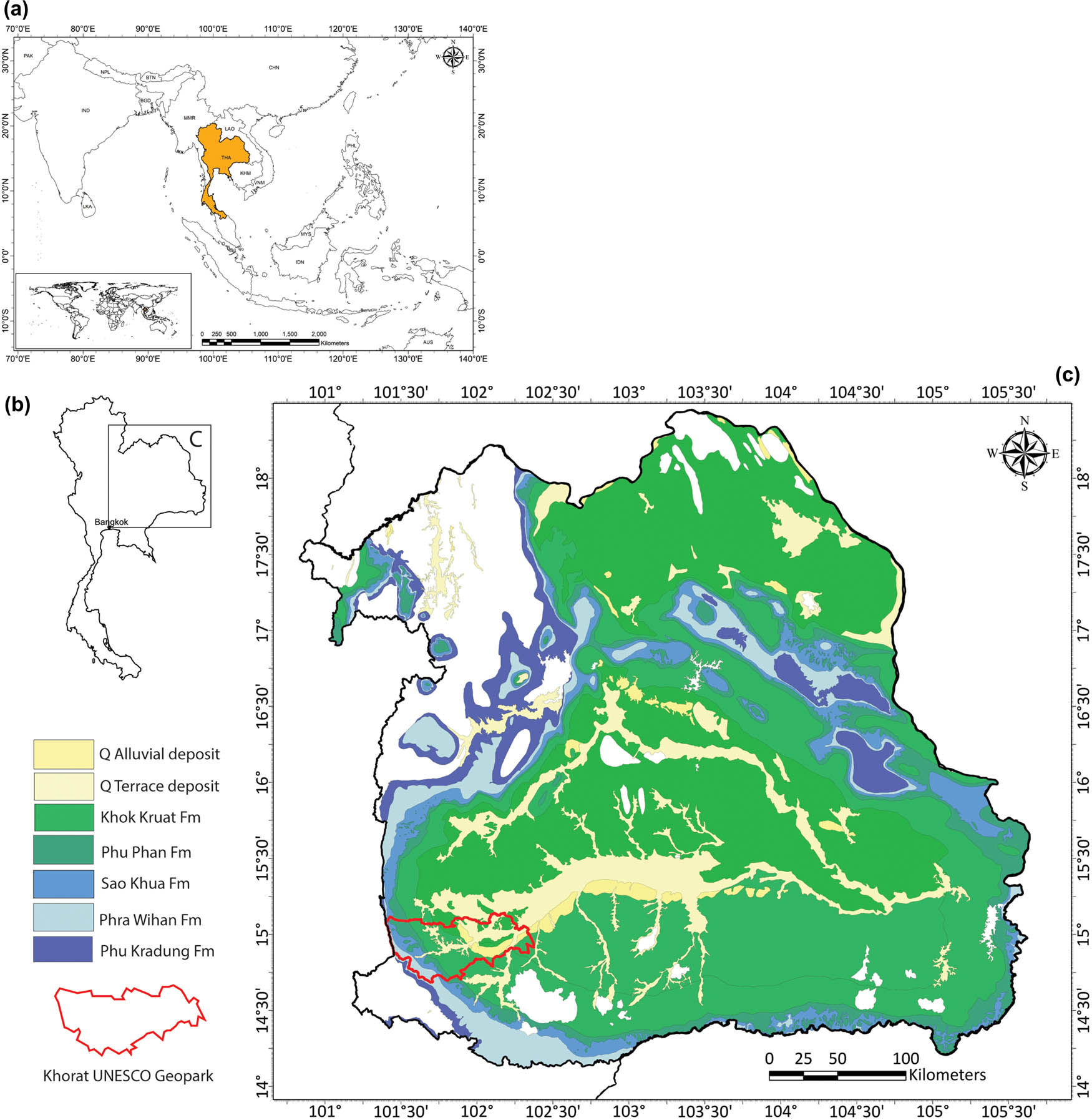
Maps of the study area. (a) Location of Thailand within Southeast Asia. (b) Regional setting showing the position of panel C. (c) Geological map of the Khorat Plateau with the boundary of the Khorat UNESCO Global Geopark.
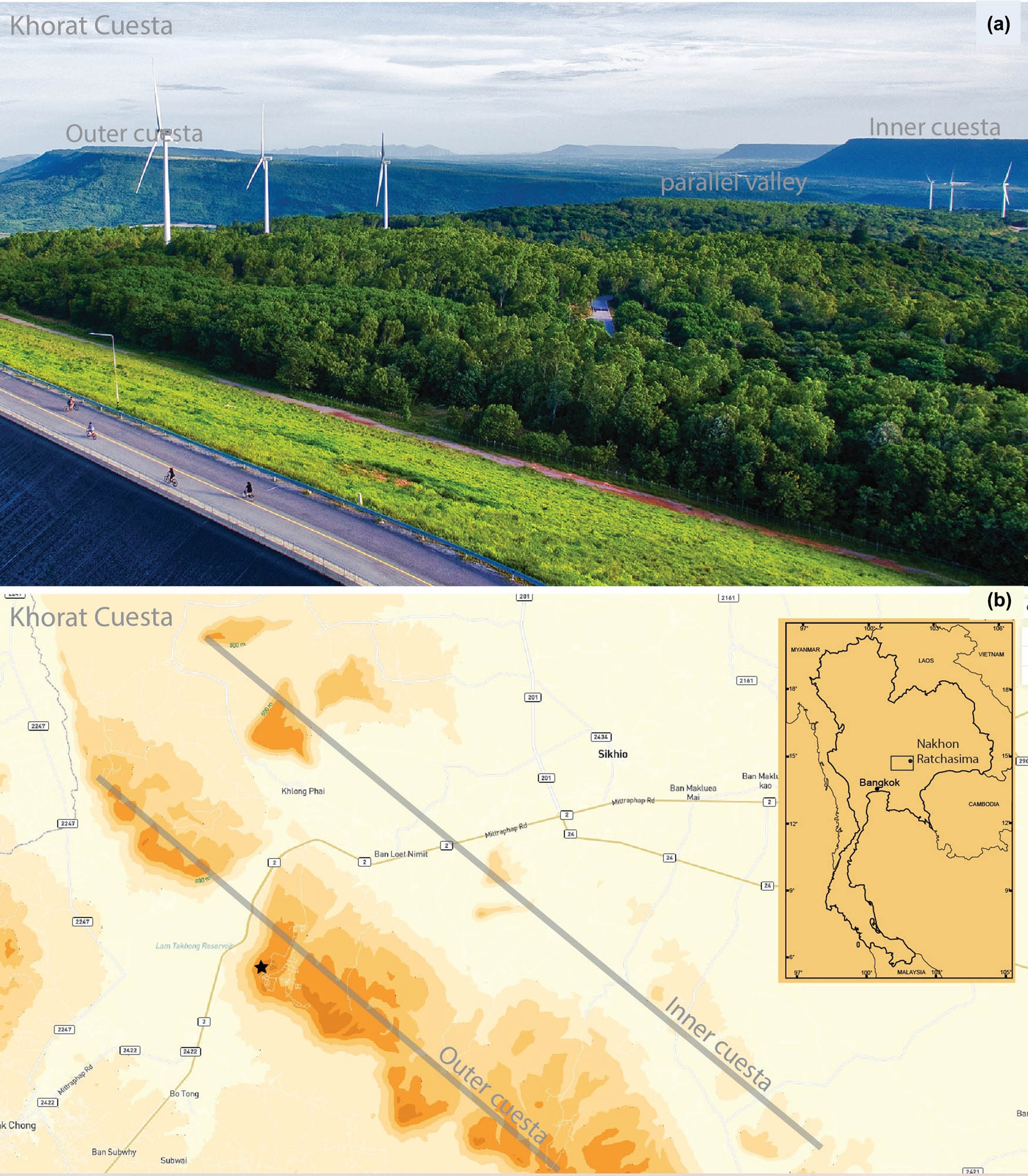
Double cuesta and strike valley of the Khorat Cuesta. (a) View from the Khao Yai Thieng viewpoint on the outer cuesta (solid star), looking north. (b) Map showing the trends of sandstone ridges and the strike valley.
Despite its geomorphological significance, no detailed studies have yet explained the developmental processes of the Khorat Cuesta. To address this gap, the objectives of the present study are twofold: (1) to characterize the physical and mechanical properties of rocks collected from both resistant and nonresistant strata, and (2) to examine the relationships between rock characteristics and the geomorphological processes that have shaped the cuesta landscape. By integrating lithological analysis with geomorphological interpretation, this study contributes to a clearer understanding of the structural and process-based controls on cuesta development. The findings not only provide insights into the landscape evolution of the Khorat UNESCO Geopark but also offer a scientific basis for conservation planning, sustainable geotourism, and the evaluation of geopark potential in Southeast Asia.
2 Geology characteristic of study area
2.1 General geology of the Khorat Plateau
The northeastern region of Thailand is characterized by elevated terrain ranging from 200 to 1,200 m a.s.l, forming what is known as the Khorat Plateau (Figure 1). This broad, shallow, basin-shaped region is slightly tilted to the southeast and is bounded by the Mekong River to the north and east, the Phetchabun Mountain Range to the west, and the Phanom Dang Raek Escarpment to the south [25]. The plateau spans nearly 200,000 km2 across northeastern Thailand and parts of Laos and features a relatively flat surface at elevations of approximately 150–200 m a.s.l. Geologically, the Khorat Plateau is primarily composed of sedimentary rocks, predominantly clastic types, including mudstones, siltstones, sandstones, and conglomerates, as well as terrestrial rock salt formations. These sedimentary units were deposited during the Late Triassic to Cretaceous periods. Underlying these Mesozoic strata are Paleozoic formations, which are locally exposed, while Cenozoic semi-consolidated sediments and recent deposits overlie parts of the sequence [26,27,28,29,30,31]. The sedimentary succession of the Khorat Plateau has been subjected to at least five major regional tectonic events: Indosinian I, II, and III, as well as Himalayan Orogeny I (Paleogene) and Himalayan Orogeny II (Oligocene–Miocene) [32,33]. The regional uplift and folding of the Mesozoic sequences during the Himalayan Orogeny I resulted from the collision between the Indian-Australian and Eurasian tectonic plates. This tectonic episode is linked to the formation of the Phu Phan Range in the central Khorat Plateau, dated between 78 and 60 Ma [34,35]. The structural framework of the plateau is defined by low-angle antiforms and synforms with general NW–SE orientations, accompanied by conjugate parasitic folds trending NE–SW, indicating the principal tectonic stress directions during these deformation phases [36]. These structural features have played a critical role in shaping the modern landscape, including the formation of tablelands, mesas, and cuestas over millions of years. Subsequently, the Himalayan Orogeny II event caused additional uplift along the western margin of the plateau, leading to the development of steep escarpments and significant elevation contrasts that define the present-day topography. As a result of the plateau’s overall inclination to the east, nearly all drainage flows toward the Mekong River [25,37]. The Mesozoic sedimentary sequence of the Khorat Plateau is collectively referred to as the Khorat Group [38,39]. This group is predominantly characterized by reddish-colored clastic sedimentary rocks of terrestrial origin, including sandstones, siltstones, claystones, shales, and conglomerates, with a cumulative thickness exceeding 5,000 m [38,39]. Based on surface investigations, the Khorat Group is subdivided into nine formations arranged in an ascending stratigraphic order: Huai Hin Lat, Nam Phong, Phu Kradung, Phra Wihan, Sao Khua, Phu Phan, Khok Kruat, Maha Sarakham, and Phu Thok Formations [40,41]. In contrast, subsurface and seismic studies have delineated six principal formations: Upper Nam Phong, Phu Kradung, Phra Wihan, Sao Khua, Phu Phan, and Khok Kruat [32,42,43]. The sedimentological and paleontological characteristics of these formations strongly support interpretations of a variety of continental depositional environments [26,31,44,45,46,47,48,49,50,51,52,53,54].
For decades, the Mesozoic rocks in northeastern Thailand have been extensively studied across various disciplines, including lithology, petrology, stratigraphy, paleontology, geochemistry, and paleomagnetism [26,27,28,29,34,55,56]. These investigations have significantly contributed to understanding the geological history of the region, particularly the provenance of sediments, paleoenvironmental conditions, paleoclimate, and the tectonic evolution of the Khorat Plateau. Although several studies have examined the mechanical properties of these rocks, their focus has primarily been limited to engineering applications [57,58,59,60,61,62]. Yet, the geomorphological significance of rock properties on the Khorat Plateau remains largely unrecognized, making this study the first to explicitly investigate their control on landscape development.
2.2 Geology of the Khorat UNESCO geopark
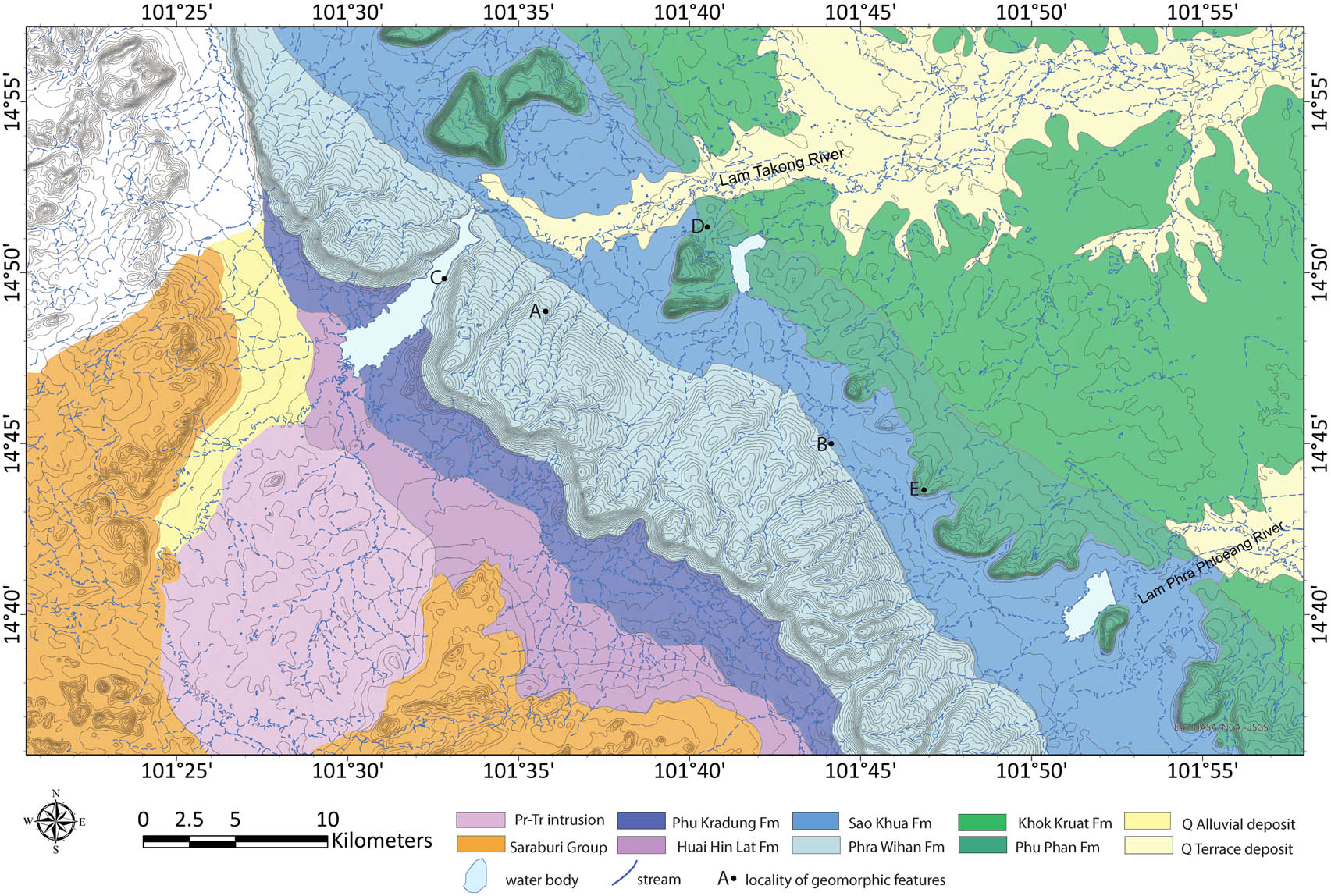
The Khorat UNESCO Geopark is in Nakhon Ratchasima Province in northeastern Thailand. It is widely recognized for its striking geomorphological features and diverse paleontological resources [23,52]. Covering an area of approximately 3,167.38 km2, the geopark is geographically situated between 14°40′48″N and 15°08′24″N, and 101°23′46″E and 102°23′53″E. The region is primarily underlain by the Mesozoic red beds of the Khorat Group (Figure 1), with locally occurring subcrops and outcrops of Cenozoic sediments [23,52]. Detailed accounts of the geology and paleontological significance of the Khorat Geopark can be provided elsewhere [23,52]. According to the recent geological mapping by the Department of Mineral Resources [63], as shown in Figure 3, the Phu Kradung, Phra Wihan, Sao Khua, Phu Phan, and Khok Kruat Formations are exposed within the geopark area, whereas the Maha Sarakham and Phu Thok Formations are not observed at the surface. The Mesozoic strata generally dip northeastward at angles of less than 10° (Figure 3). Recent fluvial sediments, particularly along the Lam Takong River and its tributaries, locally overlie the older bedrock units. The western boundary of the Khorat Geopark is defined by a prominent geomorphological feature known as the “Khorat Cuesta” [52,64,65]. This landscape consists of a pair of cuestas separated by a broad strike valley. The elevation of the valley floor is approximately 200 m a.s.l., while the cuesta ridges rise to elevations between 300 and 700 m a.s.l, forming small hills and mountains that dominate the local topography.
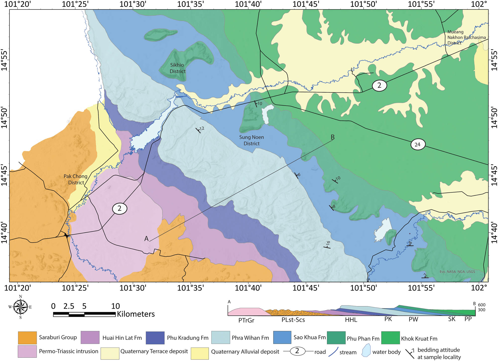
Geological map of the study area showing sampling localities and average bedding orientations.
Figures 2 and 3 illustrate that the outer cuesta is formed by the Phra Wihan Formation, the intervening strike valley is developed within the Sao Khua Formation, and the inner cuesta is formed by the Phu Phan Formation. The outer cuesta is underlain by the Phu Kradung Formation, which lies outside the current boundary of the Khorat Geopark. To the east of the inner cuesta, the floodplain area is underlain by the Khok Kruat Formation. A brief stratigraphic overview of these formations, presented in ascending order, is provided below.
The Phu Kradung Formation [38] consists of siltstones, claystones, and micaceous sandstones characterized by Fe-oxide mottling, calcrete nodules, caliche, and nodular silcrete. Its thickness ranges from approximately 800 to 1,200 m. Based on palynomorphs, bivalves, and fossil vertebrates, this unit is dated to the Late Jurassic to Early Cretaceous [26,66,67].
The Phra Wihan Formation is composed almost entirely of yellowish-brown to white, fine- to coarse-grained, well-sorted sandstones of arkosic to orthoquartzitic composition, the Phra Wihan Formation includes only minor siltstones and mudstones. Its thickness varies from 100 to 250 m. The formation is dated to the Early Cretaceous based on fossil and palynomorph evidence [26] and more specifically to the Berriasian age based on sedimentological characteristics [68].
The Sao Khua Formation [38] comprises cyclic deposits of reddish claystones, siltstones, and fine- to medium-grained sandstones, along with conglomerates containing caliche, calcrete nodules, and nodular silcrete. These lithologies represent a low-energy fluvial environment characterized by meandering channels and floodplains, with thicknesses ranging from 200 to 700 m. The formation has yielded the richest and most diverse fossil vertebrate assemblages in Thailand, including hybodont sharks, actinopterygian fish, turtles, crocodilians, and both theropod and sauropod dinosaurs [69,70]. Its age is assigned to the Early Cretaceous (Valanginian to Barremian), based on palynological, invertebrate, dinosaur, and radiometric data [68,70].
The Phu Phan Formation [38] primarily consists of white to pale gray and pale yellowish-brown, medium- to coarse-grained sandstones and conglomeratic sandstones, with occasional siltstones and mudstones. Pebbly conglomerates with well-rounded quartz pebbles and mudstone intraclasts are also present [44]. The formation ranges from 80 to 140 m thick and is assigned an Early Cretaceous age (Hauterivian to Aptian), based on the ages of the bounding formations [26,68].
The Khok Kruat Formation is 400–700 m thick and composed predominantly of reddish-brown to maroon, fine- to medium-grained micaceous or arkosic sandstones. These are interbedded with calcareous conglomerates, siltstones, and mudstones [29]. This formation has yielded vertebrate fossils such as hybodont sharks, turtles, crocodilians, and various dinosaurs including theropods, ceratopsians, and ornithopods [71,72]. The unit is dated to the late Early Cretaceous (Aptian to Albian) based on its fossil content.
3 Materials and methods
3.1 Geomorphological analysis
In this study, geomorphological analysis was conducted using geographic information system (GIS) and remote sensing techniques. Elevation data were derived from the Shuttle Radar Topography Mission (SRTM) Version 3 digital elevation model (DEM) at 30 m resolution, which was used to analyze slope, hillshade, and drainage patterns across the study area. Prior to analysis, the DEM was preprocessed in ArcMap 10.x using the Fill function to remove artificial sinks and raised cells, thereby ensuring hydrological consistency. The corrected DEM was then applied to generate surface coverage measurements, hillshade visualizations, topographic and geological maps, and drainage networks for geomorphological interpretation, which formed the basis of the subsequent discussion.
3.2 Field investigation
Field investigations were conducted in 2019, focusing on natural exposures in the western part of the Khorat Geopark. Eight sampling localities within the Phra Wihan, Sao Khua, and Phu Phan Formations were purposively selected for detailed observation. The selection emphasized sites with geotourism potential, providing additional information to support interpretation and storytelling in tourist field guides, as well as localities previously examined in earlier studies. The surveyed outcrops include both officially designated Khorat Geopark geosites [64] and naturally occurring exposures. Locations of the sampling localities are shown in Table 1 and Figure 3. However, access to some localities was constrained by dense vegetation in sanctuaries and protected areas.
Sampling localities, lithologic descriptions, and rock classifications
| Sample | Description | Classification |
|---|---|---|
| Phra Wihan Formation | ||
| Wat Phu Pha Chan – location A (14°39′54.41″N, 101°54′0.32″E) | ||
| 19PW01 | Reddish brown, fine-grained, well sorted, subangular-sub rounded, noncalcareous, highly weathered; Munsel color 5YR4/4 (fresh), 5YR4/8 (weathered) | Fine-grained sandstone |
| 19PW02 | Pale reddish brown, fine-grained, well sorted, subangular-sub rounded, noncalcareous, highly weathered; peppered with small amount of opaque minerals and mica; Munsel color 5YR4/4 (fresh), 5YR4/8 (weathered) | Fine-grained sandstone |
| 19PW03 | Pale reddish brown, very fine grained; Munsel color 5Y7/6-5Y7/8. | Very fine-grained sandstone |
| Wat Khao Chan Ngam – location B (14°48′52.2″N, 101°35′41.30″E) | ||
| 19PW04 | Pale reddish brown, fine grained, containing mudstone pebbles; well sorted, noncalcareous; Munsel color 5YR4/4; with opaque minerals | Fine-grained sandstone |
| 19PW05 | Pale reddish-white, fine grained, containing mudstone pebbles; well sorted, noncalcareous; Munsel color 5YR4/4; with opaque minerals | Fine-grained sandstone |
| 19PW06 | Reddish round, fine grained, well sorted, subangular-sub rounded, noncalcareous; Munsel color 5YR5/2-5YR5/4-2.5R4/4 | Fine-grained sandstone |
| Wat Khao Saad – location C (14°44′59.2″N, 101°44′13.17″E) | ||
| 19PW08 | White, medium grained; well sorted, subangular-sub rounded, noncalcareous; Munsel color 7.5Y8/2-7.5Y7/2; with opaque minerals | Medium-grained sandstone |
| 19PW09 | Pale reddish brown, fine grained; well sorted; Munsel color 5Y7/6-5Y7/8, with opaque minerals | Fine-grained sandstone |
| 19PW10 | Pale reddish grey, very fine grained; well sorted; Munsel color 10B6/2-10B5/2 | Very fine-grained sandstone |
| Sau Khua Formation | ||
| Location D (14°36′6.95″N, 101°55′19.82″E) | ||
| 19SK01 | Pale reddish grey, very fine grained, containing mica; well sorted; slightly reacted to HCl; Munsel color 7.5P3/2 | Very fine-grained micaceous sandstone |
| 19SK02 | Pale reddish grey, very fine grained (Munsel color 7.5P3/2-5P3/2); with mudstone-siltstone pebbles (Munsel color 2.5RP3/2); containing muscovite; slightly reacted to HCl | Conglomeratic sandstone |
| 19SK03 | Pale reddish grey, very fine grained, containing mica; showing lamination; slightly reacted to HCl; Munsel color 7.5P3/2 | Very fine-grained micaceous sandstone |
| 19SK04 | Pale greyish brown, very fine grained, containing mica; well sorted; with mudstone pebbles; Munsel color 7.5P3/2; reacted to HCl | Very fine-grained micaceous sandstone |
| 19SK05 | Greyish brown, very fine grained, containing mica; well sorted; Munsel color 5R4/2-5R3/2; reacted to HCl | Very fine-grained micaceous sandstone |
| 19SK06 | Pale reddish grey, very fine grained, containing mica; Munsel color 7.5R3/2-7.5R3/4; reacted to HCl | Very fine-grained micaceous sandstone |
| Khao Tum Yae – location E (14°38′54.41″N, 101°54′0.32″E) | ||
| 19TY01 | Pale greyish brown; matrix very fine grained (Munsel color 7.5P3/2); containing mudstone-siltstone pebbles (Munsel color 2.5RP3/2); reacted to HCl | Conglomeratic sandstone |
| 19TY02 | Reddish brown, fine grained, well sorted; reacted to HCl; Munsel color 2.5YR4/2-2.5YR3/2 | Fine-grained sandstone |
| 19TY03 | Reddish brown; matrix is medium grained containing pebbles; quartz-siltstone-mudstone pebbles are 2 mm.-1.0 cm; Munsel color 2.5YR6/2-2.5YR7/2; reacted to HCl | Conglomeratic sandstone |
| 19TY04 | Pale greyish brown, matrix is very fine grained; mudstone-quartz-chert pebbles and calcareous nodules are 2.0 mm.- > 2.0 cm; Munsel color 5Y4/2-5Y3/2-5Y5/4; reacted to HCl | Calcrete |
| 19TY05 | Pale greyish brown, very fine grained; reacted to HCl; Munsel color 5Y3/2-5Y4/2 | Very fine-grained sandstone |
| 19TY10 | Fine grained, containing mudstone pebbles; reacted to HCl; Munsel color 5Y3/2-5Y4/2 | Fine-grained sandstone |
| Phu Phan Formation | ||
| Si Khio Stone Quarry – location F (14°51′21.2″N, 101°40′35.50″E) | ||
| 19PP01 | Pale brownish white, fine grained, well sorted, peppered with small amount of opaque minerals; Munsel color 7.5Y8/2-7.5Y7/2 | Fine-grained sandstone |
| 19PP02 | Pale greyish brown, fine grained, well sorted, peppered with small amount of opaque minerals, slightly reacted to HCl; Munsel color 10B6/2-10B5/2 | Fine-grained sandstone |
| Khao Kueng – location G (14°44′28.40″N, 101°47′30.19″E) | ||
| 19PP03 | White, medium- to coarse-grained sandstone, moderate-sorted, subangular to subrounded, peppered with 10–15% of opaque minerals; Munsel color 7.5Y8/2-7.5Y7/2 | Medium- to coarse-grained sandstone |
| 19PP04 | Pale reddish-white, very coarse- to coarse-grained, moderate-sorted, subangular, with few pebbles (size > 3 cm) and reddish silt-size matrix, reacted to HCl; Munsel color 5YR6/2-5YR7/2 | Very coarse- to coarse-grained sandstone |
| Wat Pa Mongkol Tham – location H (14°42′7.8″N, 101°47′12.9″E) | ||
| 19PP05 | Pale reddish white, medium grained, well sorted, subrounded; Munsel color 5YR8/2-5YR8/4 | Medium-grained sandstone |
| 19PP06 | White, medium grained, well sorted, peppered with a small amount of opaque minerals; Munsel color 7.5Y8/2-7.5Y7/2 | Medium-grained sandstone |
| Khao Lom Fang – location D (14°36′6.95″N, 101°55′19.82″E) | ||
| 19PP07 | White, medium grained, Munsel color 7.5Y8/2-7.5Y7/2; with pebbles (quartz, feldspar, rock fragments), and 10% opaque minerals. | Medium-grained sandstone |
| 19PP08 | Pale reddish white, fine to medium grained, moderate sorted; Munsel color 5YR8/2-5YR8/4 | Fine- to medium-grained sandstone |
| Khao Tum Yae – location E (14°38′54.41″N, 101°54′0.32″E) | ||
| 19TY07 | White, medium grained; peppered with 5-20% opaque minerals; Munsel color 5Y7/2-5Y6/2 | Medium-grained sandstone |
| 19TY08 | Reddish brown, matrix is medium grained containing quartz pebbles (<5.0 mm); Munsel color 2.5YR2/4-2.5YR2/6 | Conglomeratic sandstone |
| 19TY09 | Reddish brown, matrix is medium to coarse grained sandstone; quartz pebbles are 2 mm.-2.0 cm; Munsel color 2.5YR2/4-2.5YR2/6-2.5YR3/6, 2.5YR3/8 | Conglomeratic sandstone |
At each locality, primary and secondary structures were examined, and rock types were identified in the field. Representative rock samples were then collected for laboratory analysis. In total, 32 rock samples were collected for this study. Samples were categorized based on their formation and labeled as 19PWxx, 19SKxx, and 19PPxx for the Phra Wihan, Sao Khua, and Phu Phan Formations, respectively. Sample set 19TYxx was also collected from a stratigraphic transition zone between the Sao Khua and Phu Phan Formations. Within this group, samples 19TY01–19TY06 and 19TY10 are assigned to the Sao Khua Formation, while 19TY07–19TY09 are attributed to the Phu Phan Formation. All samples were processed at the Geotechnology Laboratory, Suranaree University of Technology. Polished sections were prepared for petrographic analysis, during which physical characteristics, such as grain size, texture, types of gravel, and cementing materials, were documented.
3.3 Chemical analysis
Mineralogical compositions were determined from powdered samples using X-ray diffraction (XRD) analysis with a BRUKER D2 Phaser. XRD patterns were recorded over 2θ ranges of 5°–70° and 5°–60°, using a step size of 0.02°. The resulting data were analyzed using Bruker DiffracPlus EVA software to identify mineral phases, and relative abundances were estimated based on peak intensities. XRD analyses were conducted at the Synchrotron Light Research Institute, Nakhon Ratchasima.
3.4 Rock property testing
Selected rock samples were also subjected to mechanical testing. Dry density and water content were measured according to ASTM D6473–15 [73]. Rock strength was evaluated using the point load index test (ASTM D5731–16) [74], while durability was assessed using the slake durability index (SDI) test, extended to 10 cycles under room temperature conditions to evaluate long-term disintegration trends [58,75]. Mechanical testing was conducted at the Geomechanics Laboratory of Suranaree University of Technology.
4 Results
4.1 Topographic and geomorphological analysis
The topographic and geomorphological analysis revealed the asymmetric topography characteristic of the Khorat Cuesta using GIS-based analysis. The elevation map highlights two prominent cuestas as outer and inner cuestas trending NW-SE, and cuesta ridges trending NE-SW along the western margin of the Khorat Plateau, with elevations ranging from approximately 200 to 1,200 m a.s.l. (Figure 4a), while Figure 4b exhibits the escarpment faces and dip slope using visual delineation. The intervening strike valley exhibits relatively lower elevations and a more subdued relief, reflecting preferential erosion of less resistant lithologies. The valley floor lies at 200–330 m a.s.l., while the cuesta ridges rise to 300–700 m a.s.l. These formed prominent hills and ridges that dominate the regional topography. The hillshade background enhanced the visualization of key geomorphic features, including rugged escarpment faces, ruiniform landforms, pedestal rocks, and mesas, within the inner cuesta.
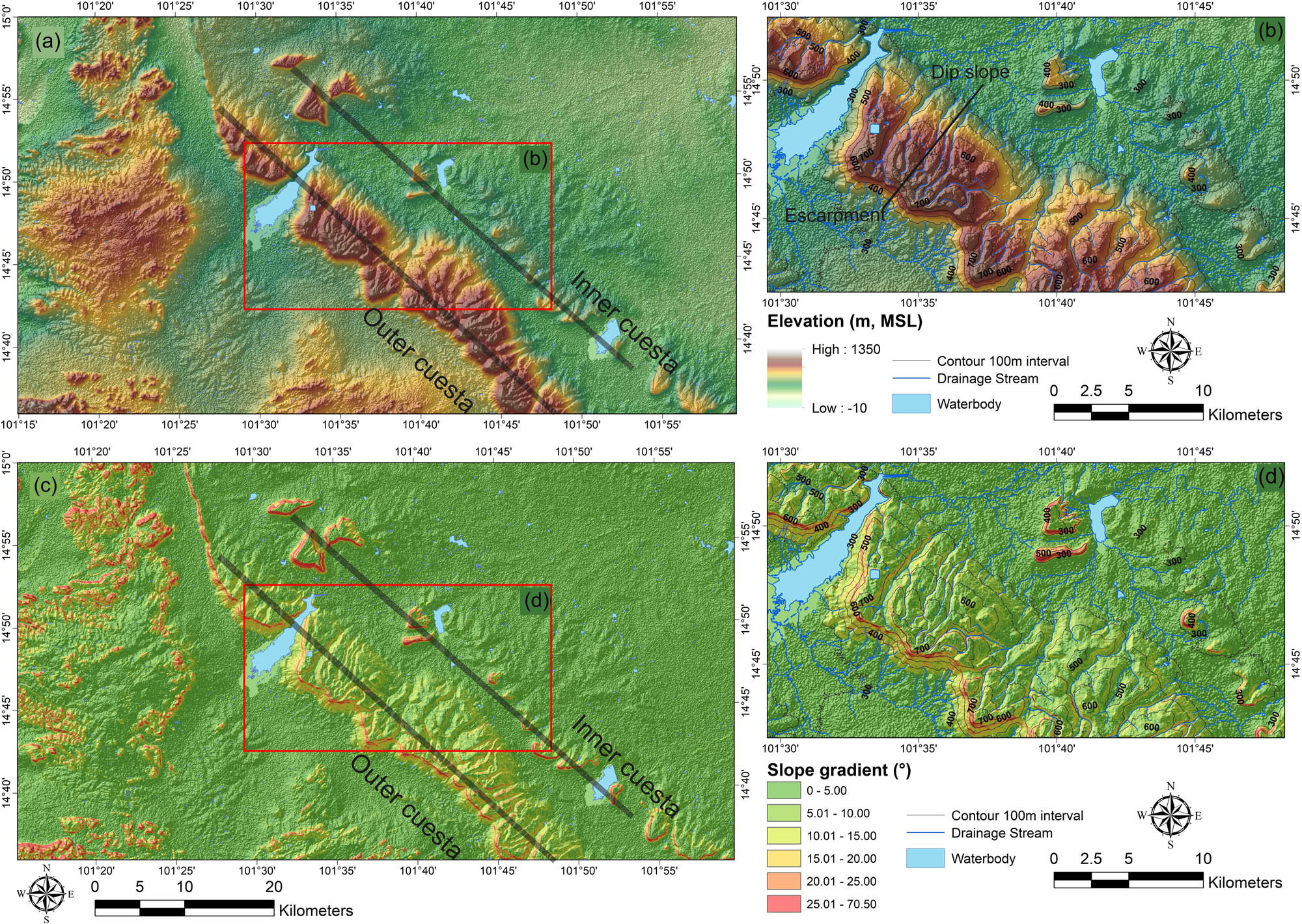
Topographic and geomorphological characteristics of the Khorat Cuesta derived from SRTM DEM analysis. (a) Elevation map showing the outer and inner cuestas and intervening strike valley. (b) Hillshade visualization highlighting escarpment faces and dip slopes. (c) Slope map illustrating the steep escarpments (>25–35°) and gentle dip slopes (<10°). (d) Drainage network analysis showing consequent streams aligned with structural lineaments and dendritic to subdendritic patterns.
Slope analysis emphasized the asymmetry of the cuesta system. Escarpment slopes are consistently steep, with gradients exceeding 25–35°, whereas dip slopes present gentle slope inclinations with less than 10° and aligned with the regional northeast direction, as shown in Figure 4c and d. This sharp contrast highlights the role of lithological resistance and differential erosion in shaping the cuesta morphology.
Drainage analysis confirms the structural and lithological controls on fluvial incision. Drainages on the dip slopes of the outer cuesta are consequent streams, they are deeply incised and aligned with NE–SW-trending lineaments along the plateau’s western margin, whereas the strike valley exhibits dendritic to subdendritic drainage in weaker lithologies. In contrast, cuesta escarpments and dip slopes display subparallel drainage, indicative of bedding-controlled runoff and erosion.
Combined results of topographic and geomorphological analysis, including the elevation, slope, hillshade, and drainage analyses, provide robust geomorphological evidence that the Khorat Cuesta evolved through the combined influence of lithology, tectonic structures, and erosional processes.
4.2 Physical and mechanical results
4.2.1 Lithology
The analyzed rock samples comprise sandstones, conglomeratic sandstones, and siltstones, exhibiting a range of colors, textures, and cementing materials (Table 1; Figures 5–7). Samples from the Phra Wihan Formation (19PWxx) are predominantly fine- to medium-grained sandstones, generally noncemented, and primarily composed of quartz and feldspar, with minor opaque minerals (Figure 5). These samples exhibit compacted fabric textures surrounded by matrix material and can be easily scratched with a geological hammer, indicating relatively low hardness.
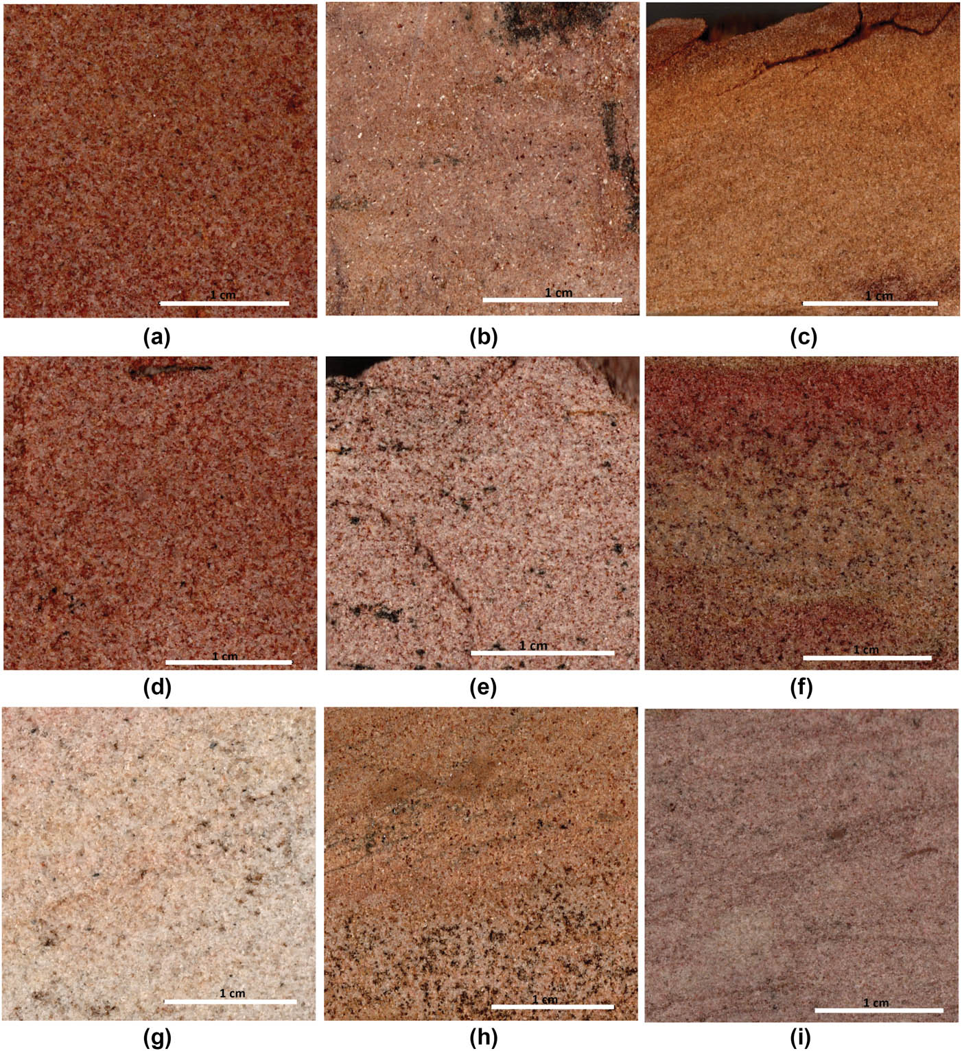
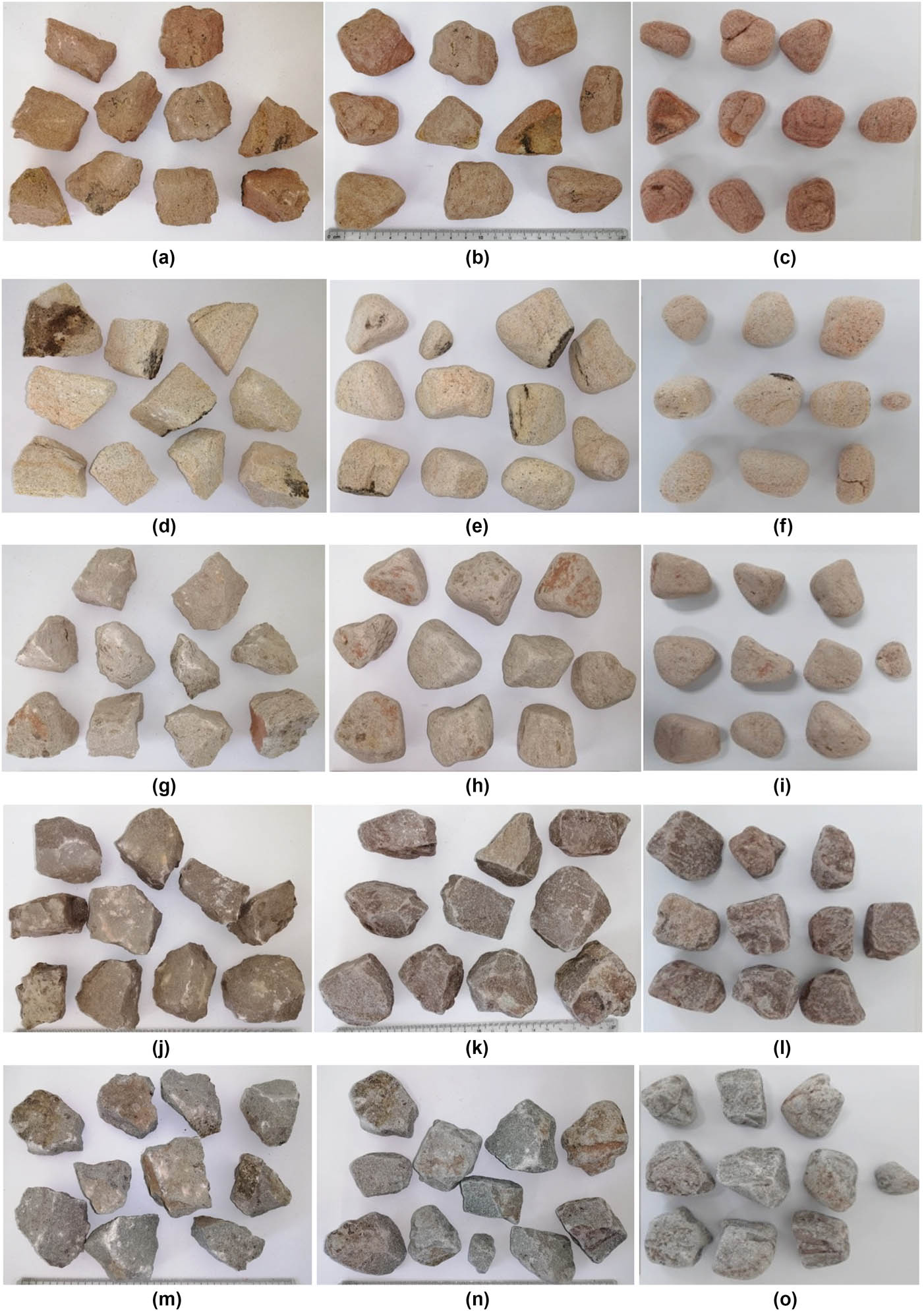
Polished slabs of the Phra Wihan samples. Scale bars = 1 cm. (a) 19PW01, (b) 19PW02, (c) 19PW03, (d) 19PW04, (e) 19PW05, (f) 19PW06, (g) 19PW08, (h) 19PW09, (i) 19PW10.
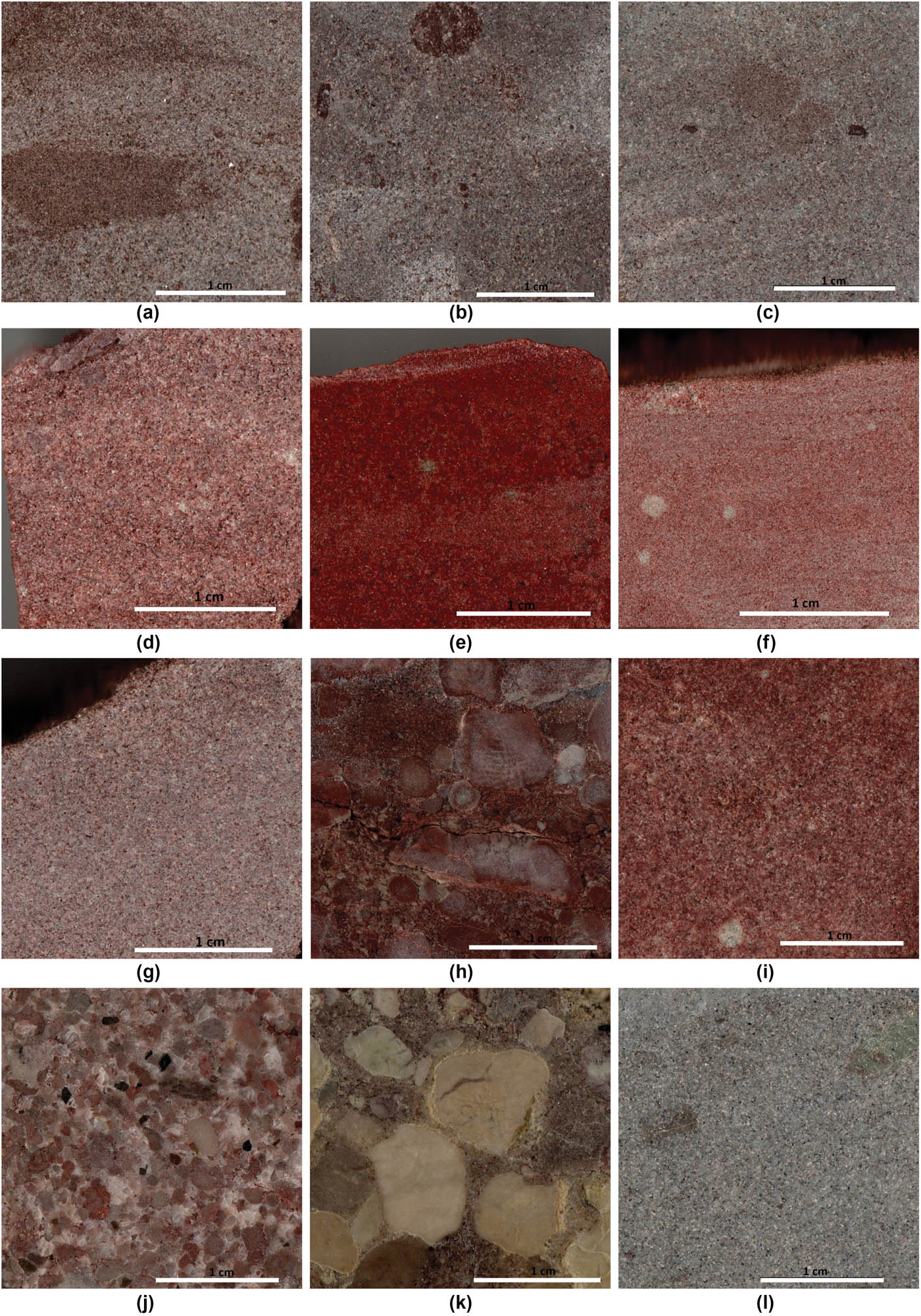
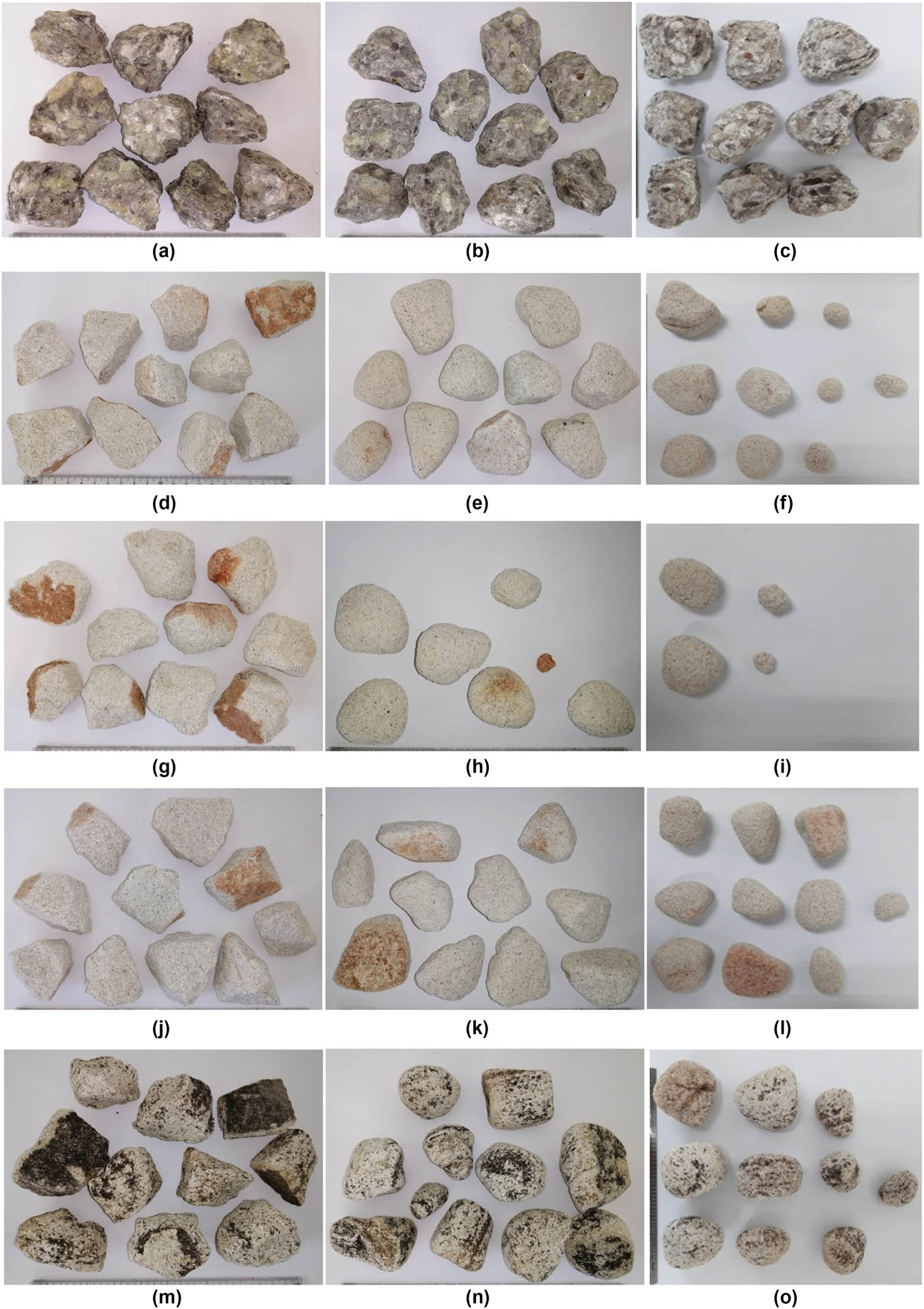
Polished slabs of the Sao Khua samples. Scale bars = 1 cm. (a) 19SK01, (b) 19SK02, (c) 19SK03, (d) 19SK04, (e) 19SK05, (f) 19SK06, (g) 19SK07, (h) 19TY01, (i) 19TY02, (j) 19TY03, (k) 19TY04, (l) 19TY05.
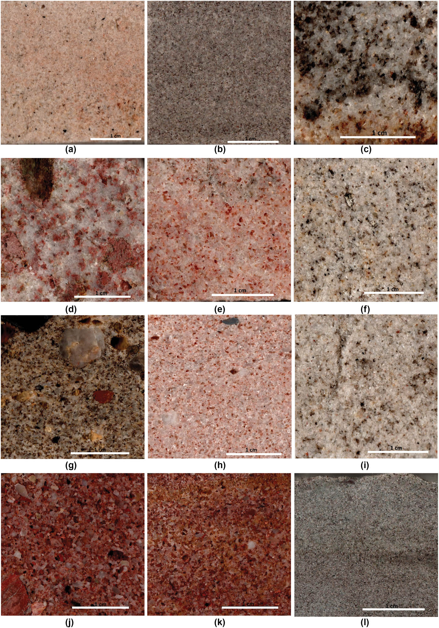
Polished slabs of the Phu Phan samples. Scale bars = 1 cm. (a) 19PP01, (b) 19PP02, (c) 19PP03, (d) 19PP04, (e) 19PP05, (f) 19PP06, (g) 19PP07, (h) 19PP08, (i) 19TY07, (j) 19TY08, (k) 19TY09, (l) 19TY10.
Samples from the Sao Khua Formation (19SKxx; 19TY01–05, 10) consist of fine-grained and conglomeratic sandstones that are cemented by calcareous material (Figure 6). Notably, sample 19TY04 is identified as calcrete, evidenced by visible cementation and a strong effervescence reaction when exposed to diluted hydrochloric acid (Figure 6k).
The Phu Phan Formation samples (19PPxx; 19TY07–09) include fine- to medium-grained sandstones and conglomeratic sandstones. Some samples – specifically 19PP02 and 19PP04 – contain significant calcite cement, as indicated by their physical appearance and mineralogical analysis (Figure 7b and d).
4.2.2 XRD analysis
Mineral compositions and their relative weight percentages were determined using XRD analysis. The results are summarized in Table 2 and illustrated in Figure 8. The primary mineral constituents identified across all samples include quartz, albite, muscovite, kaolinite, illite, chlorite, calcite, and dolomite. Quartz is the dominant mineral phase in all sandstone samples. Quartz content ranges from 66.93 to 89.12% in the Phra Wihan Formation, 57.86 to 93.59% in the Phu Phan Formation, and 42.82 to 67.69% in the Sao Khua Formation. In contrast, calcite content is notably higher in the Sao Khua Formation, ranging from 7.88 to 44.59%, whereas it is relatively low in both the Phra Wihan and Phu Phan samples.
Mineral compositions of the studied rocks from XRD analysis (Qtz = Quartz, Abl = Albite, Mus = Muscovite, Kao = Kaolinite, Ill = Illite, Chr = Chlorite, Cal = Calcite, Dol = Dolomite)
| Rock sample | Percentage of mineral content | |||||||||||||||
|---|---|---|---|---|---|---|---|---|---|---|---|---|---|---|---|---|
| Initial | After 10 cycles of slake index test | |||||||||||||||
| Qtz | Alb | Mus | Kao | Ill | Chr | Cal | Dol | Qtz | Alb | Mus | Kao | Ill | Chr | Cal | Dol | |
| 19PW01 | 85.12 | 1.48 | 3.82 | 6.28 | 0.98 | 2.23 | 0.00 | 0.09 | 86.04 | 0.93 | 1.4 | 6.58 | 1.87 | 3.01 | 0.05 | 0.13 |
| 19PW02 | 85.41 | 0.68 | 2.65 | 8.59 | 1.44 | 1.18 | 0.00 | 0.05 | 83.58 | 1.39 | 1.42 | 8.93 | 1.79 | 2.81 | 0.04 | 0.04 |
| 19PW03 | 89.12 | 1.27 | 3.01 | 3.89 | 1.85 | 0.86 | 0.00 | 0.00 | 86.91 | 1.02 | 0.54 | 4.59 | 2.43 | 4.31 | 0.05 | 0.15 |
| 19PW04 | 83.46 | 0.81 | 5.03 | 8.40 | 0.87 | 1.38 | 0.03 | 0.02 | 65.60 | 0.75 | 1.79 | 22.59 | 5.42 | 3.70 | 0.00 | 0.15 |
| 19PW05 | 81.79 | 0.61 | 1.64 | 9.74 | 5.05 | 1.14 | 0.03 | 0.00 | 74.35 | 0.43 | 2.89 | 12.97 | 7.31 | 1.99 | 0.06 | 0.01 |
| 19PW06 | 81.87 | 0.96 | 2.93 | 8.10 | 4.98 | 1.13 | 0.04 | 0.00 | 70.70 | 0.28 | 2.39 | 16.29 | 8.00 | 2.31 | 0.00 | 0.04 |
| 19PW08 | 82.44 | 1.33 | 3.72 | 10.04 | 1.14 | 1.21 | 0.06 | 0.05 | 66.11 | 0.62 | 1.24 | 23.84 | 6.00 | 2.05 | 0.05 | 0.09 |
| 19PW09 | 78.34 | 0.87 | 4.52 | 7.75 | 4.70 | 3.81 | 0.02 | 0.00 | 77.47 | 0.44 | 2.34 | 9.68 | 5.40 | 4.56 | 0.00 | 0.11 |
| 19PW10 | 66.93 | 7.37 | 5.55 | 4.50 | 9.42 | 5.91 | 0.17 | 0.16 | 68.82 | 3.69 | 2.20 | 6.61 | 15.41 | 3.11 | 0.08 | 0.09 |
| 19SK01 | 59.47 | 9.12 | 1.60 | 3.14 | 10.66 | 6.46 | 9.34 | 0.21 | 56.13 | 8.23 | 0.61 | 0.88 | 24.21 | 8.06 | 1.49 | 0.39 |
| 19SK02 | 49.28 | 1.25 | 4.29 | 3.04 | 9.50 | 1.31 | 30.57 | 0.76 | 51.02 | 2.17 | 0.63 | 1.14 | 14.47 | 6.37 | 23.24 | 0.97 |
| 19SK03 | 42.82 | 16.99 | 1.26 | 2.37 | 13.75 | 6.6 | 15.72 | 0.48 | 56.39 | 5.86 | 1.03 | 1.13 | 13.03 | 9.87 | 11.31 | 1.39 |
| 19SK04 | 54.58 | 4.51 | 3.96 | 2.88 | 3.17 | 2.86 | 26.87 | 1.17 | 61.37 | 6.82 | 0.39 | 1.01 | 4.64 | 7.62 | 17.68 | 0.47 |
| 19SK05 | 43.21 | 3.72 | 0.37 | 0.22 | 6.39 | 1.09 | 44.59 | 0.4 | 40.22 | 1.77 | 1.34 | 0.00 | 7.66 | 12.33 | 35.41 | 1.26 |
| 19SK06 | 58.84 | 3.98 | 0.90 | 0.81 | 6.94 | 2.2 | 25.55 | 0.77 | 63.52 | 4.28 | 0.32 | 0.29 | 18.09 | 7.24 | 1.10 | 5.15 |
| 19PP01 | 82.29 | 2.04 | 0.37 | 2.57 | 8.76 | 2.26 | 0.51 | 1.21 | 80.14 | 0.90 | 1.25 | 2.61 | 9.28 | 5.54 | 0.21 | 0.08 |
| 19PP02 | 57.86 | 8.47 | 2.59 | 4.81 | 7.00 | 2.06 | 16.75 | 0.46 | 62.40 | 4.17 | 4.86 | 2.13 | 10.96 | 5.02 | 10.45 | 0.01 |
| 19PP03 | 86.75 | 2.53 | 1.53 | 3.76 | 3.73 | 0.61 | 0.43 | 0.64 | 79.95 | 2.02 | 1.85 | 2.59 | 8.38 | 4.99 | 0.14 | 0.07 |
| 19PP04 | 82.48 | 1.18 | 0.40 | 11.48 | 0.75 | 0.63 | 2.76 | 0.31 | 74.93 | 0.81 | 2.30 | 3.29 | 10.54 | 7.43 | 0.30 | 0.40 |
| 19PP05 | 86.86 | 1.88 | 0.35 | 6.67 | 2.31 | 0.89 | 0.70 | 0.33 | 80.70 | 0.97 | 1.66 | 2.93 | 6.64 | 7.07 | 0.03 | 0.02 |
| 19PP06 | 79.27 | 2.99 | 0.36 | 8.82 | 6.47 | 1.47 | 0.52 | 0.11 | 61.67 | 3.62 | 3.42 | 5.41 | 14.58 | 11.00 | 0.07 | 0.25 |
| 19PP07 | 89.54 | 0.51 | 0.61 | 8.10 | 0.42 | 0.47 | 0.29 | 0.07 | 76.72 | 0.82 | 3.63 | 3.10 | 10.08 | 5.38 | 0.04 | 0.22 |
| 19PP08 | 93.59 | 0.28 | 0.52 | 4.25 | 0.17 | 0.48 | 0.54 | 0.17 | 75.74 | 1.32 | 1.50 | 3.74 | 8.49 | 8.44 | 0.17 | 0.6 |
| 19TY01 | 48.52 | 2.32 | 1.57 | 1.84 | 14.23 | 4.21 | 27.32 | 0.00 | 58.41 | 1.13 | 5.68 | 14.76 | 4.68 | 3.58 | 11.75 | 0.00 |
| 19TY02 | 67.69 | 2.75 | 3.46 | 12.19 | 2.76 | 3.28 | 7.88 | 0.00 | 38.94 | 1.34 | 5.48 | 1.86 | 4.00 | 0.56 | 47.82 | 0.00 |
| 19TY03 | 55.78 | 0.28 | 1.56 | 0.42 | 0.60 | 0.00 | 41.32 | 0.04 | 31.51 | 0.41 | 2.18 | 0.34 | 7.45 | 1.01 | 57.1 | 0.00 |
| 19TY04 | 49.39 | 7.28 | 3.26 | 2.24 | 15.59 | 4.77 | 17.48 | 0.00 | 25.79 | 0.32 | 4.82 | 0.17 | 14.95 | 2.41 | 51.53 | 0.00 |
| 19TY05 | 54.83 | 15.2 | 3.11 | 2.02 | 3.47 | 3.01 | 18.31 | 0.05 | 39.28 | 3.21 | 7.53 | 1.40 | 6.85 | 2.87 | 38.85 | 0.01 |
| 19TY07 | 72.59 | 5.47 | 2.16 | 15.9 | 3.84 | 0.00 | 0.04 | 0.00 | 57.29 | 6.36 | 3.81 | 5.81 | 14.18 | 11.56 | 0.84 | 0.15 |
| 19TY08 | 77.74 | 1.92 | 2.55 | 15.49 | 1.03 | 0.56 | 0.53 | 0.17 | 66.31 | 0.85 | 2.43 | 4.71 | 4.01 | 17.61 | 4.00 | 0.08 |
| 19TY09 | 90.49 | 1.98 | 0.83 | 5.40 | 0.58 | 0.56 | 0.09 | 0.08 | 73.07 | 1.02 | 1.54 | 4.53 | 2.59 | 17.13 | 0.01 | 0.12 |
| 19TY10 | 65.85 | 11.96 | 1.84 | 6.43 | 1.84 | 1.44 | 10.64 | 0.00 | 48.68 | 5.22 | 14.37 | 1.44 | 10.94 | 5.37 | 13.89 | 0.09 |
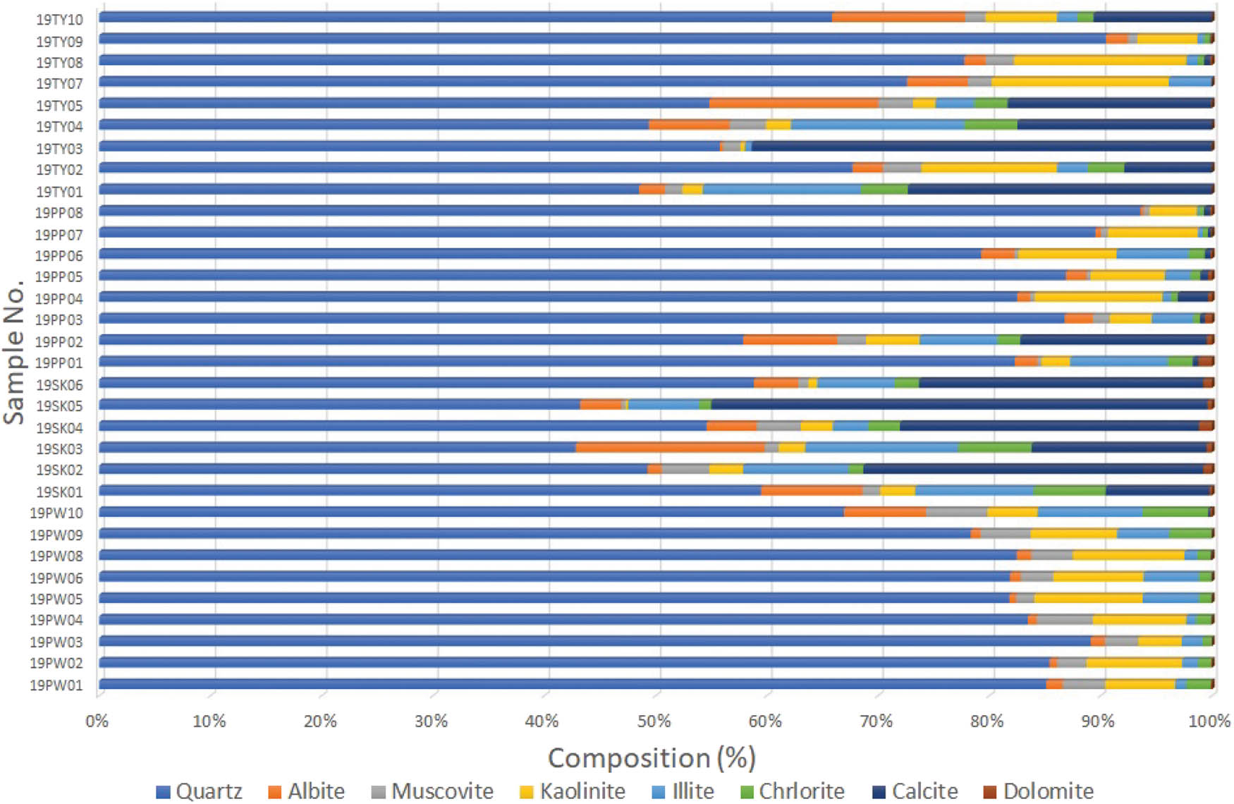
Percentage of mineral content of the rocks studied from XRD analysis.
4.2.3 Point load strength index test
The physical and mechanical properties of the studied sandstone samples are summarized in Table 3. Dry density values range from 2.13 to 2.69 g/cm3, with porosity ranging from 6.34 to 18.24%. The moisture content across all samples was found to be very low. For the point load strength testing, three core blocks were prepared for each sample. Each was subjected to a compressive point load, and the point load strength index (I s ) was calculated. The values were then standardized to a 50 mm equivalent core diameter, denoted as I s(50). In addition, uniaxial compressive strength (UCS) values were estimated based on the standardized strength indices.
Physical and mechanical properties of rock samples from the Phra Wihan, Sao Khua, and Phu Phan Formations
| Rock sample | Bulk density (g/cm3) | Moisture Content (%) | Porosity (%) | Average I s(50) (MPa) | Estimate σ c (MPa) |
|---|---|---|---|---|---|
| 19PW01 | 2.52 | 0.21 | 9.55 | 2.93 | 67.47 |
| 19PW02 | 2.56 | 0.18 | 9.51 | 3.98 | 91.63 |
| 19PW03 | 2.51 | 0.16 | 8.84 | 1.54 | 35.48 |
| 19PW04 | 2.35 | 0.09 | 12.01 | 1.39 | 32.07 |
| 19PW05 | 2.29 | 0.17 | 13.40 | 0.92 | 21.19 |
| 19PW06 | 2.36 | 0.18 | 12.10 | 2.83 | 65.00 |
| 19PW08 | 2.32 | 0.08 | 10.44 | 0.36 | 8.25 |
| 19PW09 | 2.36 | 0.42 | 11.50 | 2.07 | 47.70 |
| 19PW10 | 2.37 | 0.70 | 13.64 | 0.57 | 13.02 |
| 19PW01 | 2.52 | 0.21 | 9.55 | 2.93 | 67.47 |
| 19SK01 | 2.56 | 0.54 | 10.54 | 6.65 | 152.91 |
| 19SK02 | 2.59 | 0.39 | 8.22 | 6.24 | 143.52 |
| 19SK03 | 2.61 | 0.47 | 9.54 | 6.15 | 141.55 |
| 19SK04 | 2.62 | 0.24 | 9.41 | 5.22 | 119.98 |
| 19SK05 | 2.68 | 0.28 | 9.74 | 6.41 | 147.43 |
| 19SK06 | 2.67 | 0.29 | 7.14 | 2.35 | 53.99 |
| 19PP01 | 2.32 | 0.20 | 14.21 | 0.61 | 14.06 |
| 19PP02 | 2.54 | 0.46 | 10.08 | 2.53 | 58.09 |
| 19PP03 | 2.27 | 0.23 | 13.66 | 0.91 | 20.86 |
| 19PP04 | 2.13 | 0.30 | 15.20 | 0.30 | 6.91 |
| 19PP05 | 2.29 | 0.08 | 14.41 | 3.29 | 75.62 |
| 19PP06 | 2.23 | 0.29 | 14.20 | 1.24 | 28.58 |
| 19PP07 | 2.28 | 0.21 | 15.04 | 0.36 | 8.32 |
| 19PP08 | 2.29 | 0.13 | 16.10 | 0.60 | 13.71 |
| 19PP09 | 2.32 | 0.20 | 14.21 | 0.61 | 14.06 |
| 19TY01 | 2.69 | 0.45 | 7.54 | 4.15 | 95.34 |
| 19TY02 | 2.65 | 0.34 | 6.88 | 2.81 | 64.54 |
| 19TY03 | 2.65 | 0.18 | 6.45 | 3.41 | 78.32 |
| 19TY04 | 2.58 | 0.76 | 7.02 | 1.97 | 45.27 |
| 19TY05 | 2.67 | 0.36 | 6.34 | 3.08 | 70.90 |
| 19TY07 | 2.23 | 0.29 | 14.88 | 0.26 | 5.94 |
| 19TY08 | 2.38 | 0.12 | 17.02 | 3.06 | 70.46 |
| 19TY09 | 2.29 | 0.07 | 18.24 | 1.95 | 44.89 |
| 19TY10 | 2.55 | 0.51 | 12.24 | 7.12 | 163.83 |
The I s(50) values range as follows: Phra Wihan Formation: 0.36–3.98 MPa; Sao Khua Formation: 1.97–7.12 MPa; and Phu Phan Formation: 0.26–3.29 MPa. Corresponding estimates of uniaxial compressive strength are also presented in Table 3.
4.2.4 SDI test
For each sample, ten rock lumps weighing approximately 50 g each (total weight of 500 g) were subjected to slake durability testing. The standard two-cycle wet-dry procedure was performed to determine the second-cycle SDI (I d₂). Additional tests were extended from the third to the tenth cycle to observe long-term durability behavior. The results are plotted as a function of the number of cycles in Figure 9.
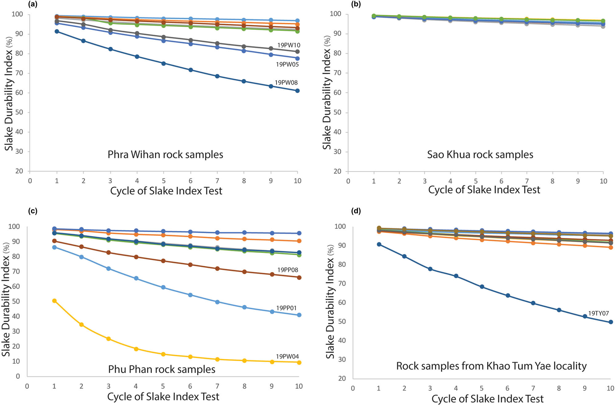
Slake durability index for 10 cycles of the studied rock samples. (a) Phra Wihan Formation. (b) Sao Khua Formation. (c) Phu Phan Formation. (d) Rock samples from Khao Tum Yae locality.
Samples from the Phra Wihan Formation display a linear degradation trend, with 19PW05, 19PW08, and 19PW10 deteriorating at notably faster rates than the others (Figures 9a and 10a–i). The I d2 values of all samples exceed 85.00%, which corresponds to medium-high to high durability according to the Slake Durability Classification of Gamble [76]. At the tenth cycle, all samples exceed 60.00%. Samples from the Sao Khua Formation exhibit more consistent and durable behavior across all ten cycles (Figures 9b and 10j–o). Similarly, the calcrete sample 19TY04 shows comparably high durability (Figure 11a–c).
Selected samples of Phra Wihan and Sao Khua Formations before, after 2 cycles, and after 10 cycles of Slake Durability Index Test. 19PWxx for Phra Wihan Formation. 19SKxx, 19TY01-19TY03 for Sao Khua Formation. (a) 19PW05, (b) 19PW05-2 cycles, (c) 19PW05-2 cycles, (d) 19PW08, (e) 19PPW08-2 cycles, (f) 19PPW08-10 cycles, (g) 19PW10, (h) 19PPW10-2 cycles, (i) 19PPW10-10 cycles, (j) 19SK01, (k) 19SK01-2 cycles, (l) 19SK01-10 cycles, (m) 19SK03, (n) 19SK03-2 cycles, (o) 19SK03-10 cycles.
Selected samples of Sao Khua and Phu Phan Formations before, after 2 cycles, and after 10 cycles of Slake Durability Index Test. 19TY04-60, 19TY10 for Sao Khua Formation, 19PPxx for Phu Phan Formation. (a) 19TY04, (b) 19TY04-2 cycles, (c) 19TY04-2 cycles, (d) 19PP01, (e) 19PP01-2 cycles, (f) 19PP01-10 cycles, (g) 19PP04, (h) 19PP04-2 cycles, (i) 19PP04-10 cycles, (j) 19PP08, (k) 19PP08-2 cycles, (l) 19PP08-10 cycles, (m) 19TY07, (n) 19TY07-2 cycles, (o) 19TY07-10 cycles.
Samples from the Phu Phan Formation display a linear degradation trend (Figure 9c and d). The I d₂ values of all samples, except for three, exceed 85.00%, which corresponds to medium-high to high durability according to Gamble [76]. Exceptions include samples 19PP01 (79.93%) and 19TY07 (84.33%), both classified as medium durability, and sample 19PP04 (34.79%), which falls under the low durability category. Samples 19PP01 (Figure 11d–f), 19PP04 (Figure 11g–i), and 19TY07 (Figure 11m–o) exhibited significantly faster degradation compared to other samples. The relationship between estimated uniaxial compressive strength and slake durability indices (after 2 and 10 cycles) is presented in Figure 12.
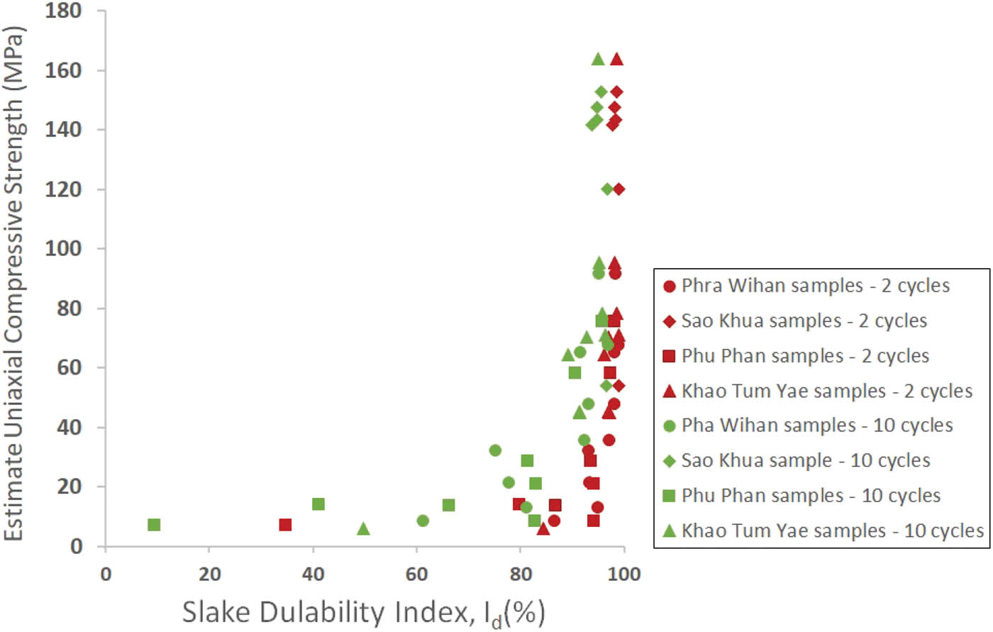
Estimated uniaxial compressive strength as a function of slake durability index for 2nd and 10th cycles.
5 Discussion
5.1 Rocks of the Phra Wihan, Sao Khua, and Phu Phan Formations
The samples from the Phra Wihan Formation examined in this study were collected from three localities along the outer Khorat Cuesta (Figure 3) and are classified as fine- to medium-grained sandstones. Mineralogically, they are composed primarily of quartz and albite, with accessory kaolinite, muscovite, illite, chlorite, and some opaque minerals. Despite forming part of the high-relief escarpment, these rocks are generally noncemented and exhibit compacted fabrics with a soft matrix, easily scratched with a geological hammer. Previous studies have investigated the lithology and provenance of the Phra Wihan Formation sandstones [55,56,77,78]. Sandstones from Chaiyaphum and Khon Kaen Provinces are similarly composed of quartz and feldspar, along with albite, kaolinite, mica, and opaque minerals, closely resembling the samples from the Khorat Geopark. Field exposures often display various types of cross-bedding, interpreted as products of high-energy, shallow braided channels with subordinate meandering systems [44]. These sandstones contribute to the formation of rugged, erosion-resistant landforms, including runiform landforms and pedestal rocks at notable geosites. Sandstones at the Hin Chang Si geosite can be classified into silica-cemented and noncemented types, which directly influence their degrees of weathering [78].
Exposures of the Sao Khua Formation are limited in the study area, as the valley between the outer and inner cuestas is predominantly covered by soil and fluvial deposits. The samples analyzed were collected from southeastern localities (Figure 3), including sites that had been previously examined [79]. These rocks are classified as fine-grained and conglomeratic sandstones, primarily composed of quartz, albite, kaolinite, illite, muscovite, and chlorite, with significant calcite content. Notably, sample 19TY04 is identified as calcrete based on its dense texture and vigorous reaction with diluted HCl. The previous study [44] reported that the Sao Khua Formation is mainly composed of fluvial sandstones and floodplain mudstones, with occasional sand-matrix-supported caliche conglomerates. However, lithological variations across the formation have been documented in different locations [78]. Results of Daorerk [79] who investigated 14 sections of the Sao Khua Formation on the Khorat Plateau were interpreted as lacustrine and fluvial depositional environments. They found the formation to consist mainly of calcareous sandstones, siltstones, claystones, and calcrete horizons, with minor conglomerates and freshwater limestones. The samples in this study correspond well to the conglomerate–sandstone–calcrete horizon lithofacies described by Daorerk [79].
The Phu Phan Formation samples were collected from the inner cuesta localities within the Khorat Geopark (Figure 3) and are classified as fine- to medium-grained sandstones and conglomeratic sandstones. They are primarily composed of quartz, albite, kaolinite, and muscovite. Samples 19PP02, 19PP04, and 19TY10 contain a notably high percentage of calcite. According to the previous study [44], the Phu Phan Formation consists mainly of quartz arenites with grain sizes ranging from fine to coarse sand, deposited in high-energy braided river channels. It also includes floodplain/lacustrine siltstones and mudstones and locally developed pebbly conglomerates. The Phu Phan sandstones in this study can be differentiated from those of the Phra Wihan Formation by their higher angularity and a greater abundance of pebble-sized clasts.
5.2 Relationships between rock strength and physical properties
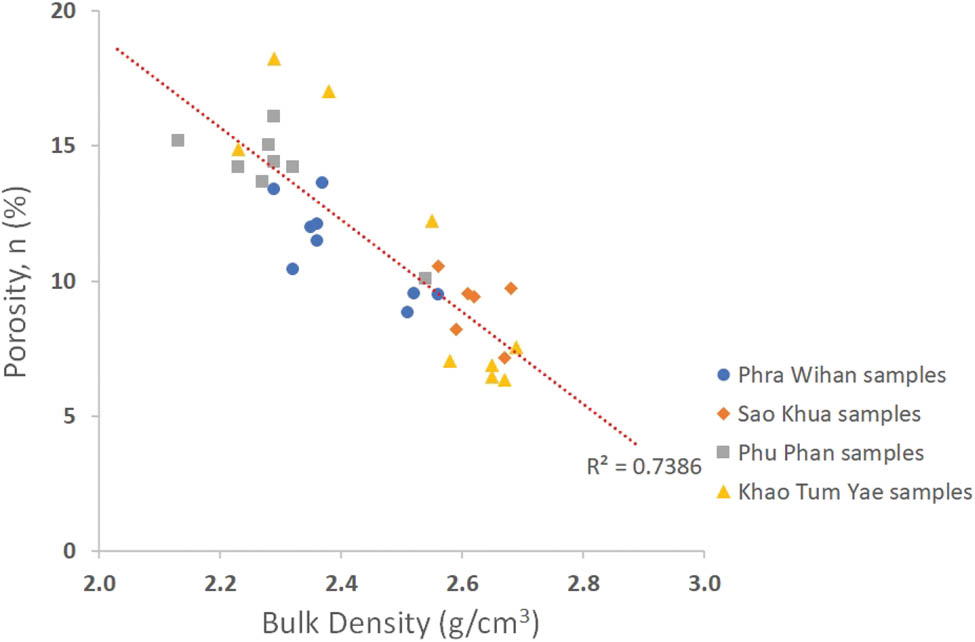
The dry density of the studied rock samples is positively correlated with their point load strength indices, as illustrated in Figure 13a. The estimated UCS, derived from I s(50) values, allows the classification of the rocks according to hardness grades (Figure 13b) following the International Society for Rock Mechanics [80]. Samples with densities below 2.5 g/cm³ fall within the range of weak rocks (R2) to strong rocks (R4), whereas samples with higher densities range from medium-strong rocks (R3) to very strong rocks (R5). All R5-classified rocks are restricted to the Sao Khua Formation (samples 19SK01–05 and 19TY10) and are characterized by very fine-grained sediments with few or no pebble inclusions. In contrast, R2-classified rocks include samples 19PW05, 19PW08, 19PW10, 19PP01, 19PP03, 19PP04, 19PP07, 19PP08, and 19TY07. These samples exhibit coarser textures and abundant translucent quartz grains (Figures 5 and 7). Overall, the very fine-grained samples tend to show higher density and greater strength, reflecting the influence of grain size on compaction and cementation. A bivariate analysis of petrophysical properties reveals a clear linear relationship between porosity and bulk density.
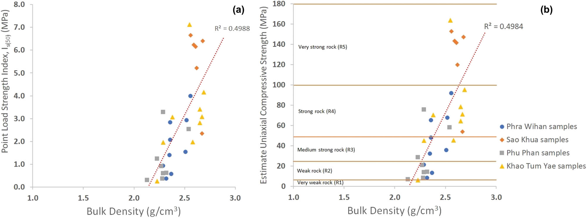
Point load strength index (a) and estimated uniaxial compressive strength (b) as a function of bulk density.
As shown in Figure 14, samples with higher porosity correspond to lower bulk densities. The correlation coefficient (R 2 = 0.7386) indicates a strong negative relationship, which is expected for siliciclastic rocks with similar matrix densities. These findings align with previous studies on the mechanical behavior of sandstones: the lower porosity and increased grain packing enhance UCS [81]; UCS and Young’s modulus in sandstone decrease with increasing porosity, water content, and mean grain size [82]. It is suggested by Pappalardo et al. [83] that sandstone strength is influenced by compactness and lithic fragment content, while porosity and pseudo-matrix components contribute to mechanical weakening. Recent advances using micro-computed tomographic imaging further confirmed that pore structure and the texture coefficient are strongly correlated with both Young’s modulus and compressive strength [84].
Point load strength index and estimated uniaxial compressive strength as a function of bulk density.
5.3 Relationships between rock strength and chemical composition
The relationship between rock strength and mineral composition – specifically the contents of quartz, calcite, mica, and clay minerals – is illustrated in Figure 15. Although all studied rock samples contain more than 40% quartz, several Phra Wihan and Phu Phan samples with high quartz content exhibit relatively low strength (Figure 15a), suggesting that quartz alone is not a sufficient predictor of mechanical performance. In contrast, calcite content appears to have a more direct influence on rock strength (Figure 15b). All R5-classified rocks contain more than 10% calcite, whereas R2-classified rocks contain less than 3%. The Sao Khua Formation samples, which are classified predominantly as R4 and R5, are characterized by a higher proportion of calcite, reinforcing the role of calcareous cement in enhancing rock strength. No clear trends were observed between rock strength and the content of mica or clay minerals (kaolinite, illite, chlorite), as shown in Figure 15c. Previous studies have highlighted the influence of chemical composition on the mechanical behavior of sandstones. Melo et al. [85] observed that the dissolution of kaolinite cement in medium- to coarse-grained sandstones was a key driver of weathering processes, leading to the development of surface erosional features such as furrows, ponds, and depressions. Lin et al. [86] found that chemical corrosion significantly altered sandstone properties by increasing total porosity and the proportion of macropores, thereby weakening the rock. Their experiments revealed that corrosion was most severe in diluted H₂SO₄, followed by NaOH and distilled water. Similarly, Chen et al. [87] demonstrated that variations in solution pH affected sandstone strength, peak strain, and elastic modulus – first increasing, then decreasing – when exposed to Na₂SO₄ solutions. In the context of Thailand, Phakdimek et al. [90] showed that the compressive and tensile strengths of sandstones from the Phra Wihan, Sao Khua, and Phu Phan Formations deteriorated after prolonged chemical weathering. After 300 wetting cycles using acidic water (pH = 5), both rock density and strength declined, with Sao Khua sandstones showing the highest sensitivity – losing 30–50% of their original mechanical performance. The findings of this study support those results, indicating that the initial high strength of the Sao Khua samples is likely attributable to increased calcite content, which enhances cohesion but is also vulnerable to chemical dissolution.
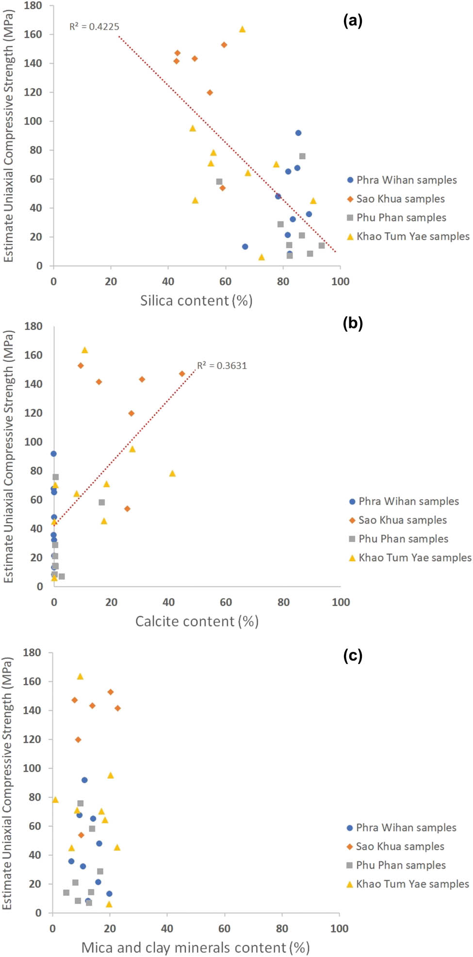
Estimated uniaxial compressive strength as a function of chemical composition: (a) compared with silica content; (b) compared with calcite content; and (c) compared with mica and clay minerals content.
5.4 Relationships between rock durability and physiochemical properties
The durability of the studied rock samples is closely associated with their physical and chemical characteristics, like their strength behavior. Results from the SDI test indicate that samples from the Sao Khua Formation – very fine-grained to fine-grained sandstones with calcite cement, including the calcrete sample 19TY04 – degraded slowly over multiple test cycles. In contrast, samples from the Phra Wihan and Phu Phan Formations, which have coarser textures, higher quartz contents, and little to no calcite cement, exhibited significantly greater weight loss during the durability tests. These findings suggest that grain size, bulk density, and the presence of calcite cement are key factors influencing the long-term durability of the tested sandstones. Fine-grained and calcite-cemented rocks tend to resist slaking and mechanical breakdown more effectively than coarser, poorly cemented equivalents. In this study, we applied the extended 10-cycle SDI test following the methodology presented by Ward and Bunnag [38] to simulate prolonged mechanical weathering. Among the samples, 19PP01 and 19PP04 exhibited a distinct nonuniform degradation pattern, where an initially weak outer layer rapidly disintegrated, followed by a slower rate of weight loss. This pattern is reflected in their concave SDI curves, indicating layered structural weakening. Several previous studies have explored the durability of Khorat Group sandstones in relation to their physiochemical properties. Torsangtham et al. [60] conducted 100-cycle slake durability tests under dry, wet, and acidic conditions on samples from the Phra Wihan, Sao Khua, and Phu Phan Formations. Their results demonstrated that all sandstones were sensitive to water, especially to acidic environments, showing rapid degradation under such conditions. They emphasized the role of cementing materials, particularly kaolinite, as a key factor affecting long-term durability. Patanapongsonti et al. [62] simulated erosional processes using 80-cycle SDI testing and found that Phu Phan sandstones were highly water sensitive, exhibiting increased porosity and reduced density under both wet and dry cycles. Conversely, Phra Wihan sandstones showed less water sensitivity but degraded more quickly under dry conditions, indicating a contrasting weathering mechanism. Overall, the results of this study confirm that Khorat Group sandstones exhibit significant variations in texture and composition and are susceptible to both mechanical and chemical weathering. The Phra Wihan and Phu Phan Formations are more influenced by mechanical disintegration, while the Sao Khua and parts of the Phu Phan Formations are more vulnerable to chemical weathering, especially in the presence of acidic moisture.
5.5 Discussion on rock control in the Khorat Cuesta evolution
The Khorat Cuesta represents a recent geomorphic expression of Mesozoic strata within the Khorat Plateau, shaped over an extended period by both tectonic and surface processes. The formation of the Khorat Plateau is primarily attributed to tectonic movements associated with the Himalayan orogeny [11,34,35]. Charusiri et al. [88] outlined four tectonic phases: (1) initial deformation of sedimentary rocks within the Khorat Basin (∼70 ± 12 Ma), forming the primary cuesta landscape; (2) major uplift and erosion (∼50 ± 5 Ma), elevating the plateau and enhancing cuesta development; and (3)–(4) subsequent strike-slip and vertical-slip faulting events (∼34 ± 3 Ma and ∼21 ± 2 Ma). Uplift and erosion during the Tertiary progressed at estimated rates between 0.12 and 0.004 mm/year. The presence of wind and water gaps along the western and southern margins of the Khorat Plateau provides evidence of a superimposed paleo-drainage system sourced from highlands to the west. Surface processes, including fluvial erosion and mass wasting, have further shaped the region through the Cenozoic [37].
Our study demonstrates that the physical, chemical, and mechanical properties of sandstones significantly influence their strength and durability, and thereby their geomorphic role in cuesta evolution. The rock samples from the Phra Wihan, Sao Khua, and Phu Phan Formations show natural variability in texture, grain size, cementation, and mineral composition. Field observations reveal that Phra Wihan sandstones are typically massive, compacted, and noncemented, except for iron oxide-stained zones. The Sao Khua Formation, generally medium to thick-bedded, comprises conglomerates, sandstones, siltstones, and mudstones with calcareous cement and localized calcrete horizons. Mudstones are exposed locally with average thicknesses less than 5 m [79, this study]. Phu Phan Formation rocks are typically coarse grained and range from medium- to very thick-bedded sandstone and conglomeratic sandstone.
Contrary to common assumptions, quartz-rich sandstones are not always strong or durable. Phra Wihan and Phu Phan samples range in strength from R2 to R4 (Figure 13b), and several degrade rapidly during slaking (Figures 9–11). In contrast, the Sao Khua samples, although finer-grained, exhibit both higher strength and durability, which we attribute to their higher density and calcite content. These results highlight the significance of grain size and cement composition, particularly calcite, in influencing mechanical behavior.
Cenozoic tectonic activities initiated the formation of the cuesta landscape and were later shaped by weathering and erosion.
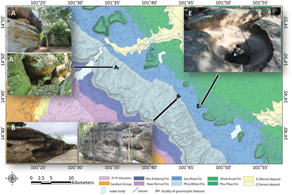
Topographic analysis (Figure 16) shows that drainages on the dip slopes of the outer cuesta are deeply incised and aligned with NE–SW–trending lineaments along the plateau’s western margin [36]. However, the escarpment itself remains steep and relatively intact, with limited headward erosion. Our results suggest that mechanical weathering processes, such as hydraulic action and abrasion, are the dominant factors in the Phra Wihan sandstones. Geomorphic features at Wat Khao Chan Ngam, a renowned tourist geosite (location A in Figure 16), including sandstone caves, jointed blocks, and mushroom rocks (Figure 17), reflect the influence of water-driven sculpting. At Wat Khao Saad (location B in Figure 16), sandstone gulls, buttresses, and lateral potholes along the contact between the Phra Wihan and Sao Khua Formations suggest ancient strike-slip stream action, which is illustrated in Figure 18a and b.
Topographic map of the study area with localities of geomorphic features.
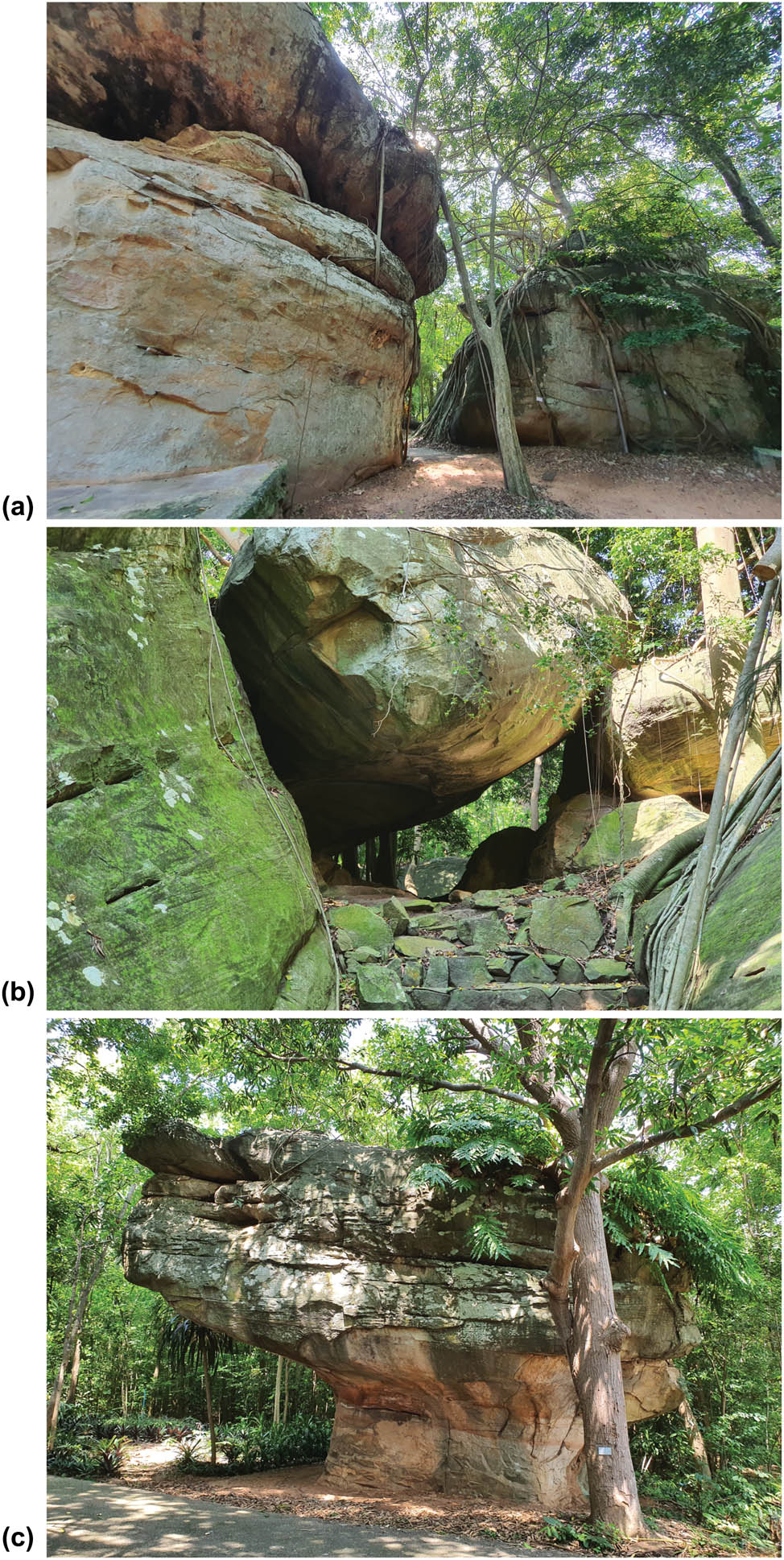
Geomorphic features at Wad Khao Chan Ngam locality. (a) Jointed sandstone block; (b) sandstone cave; and (c) mushroom rock.
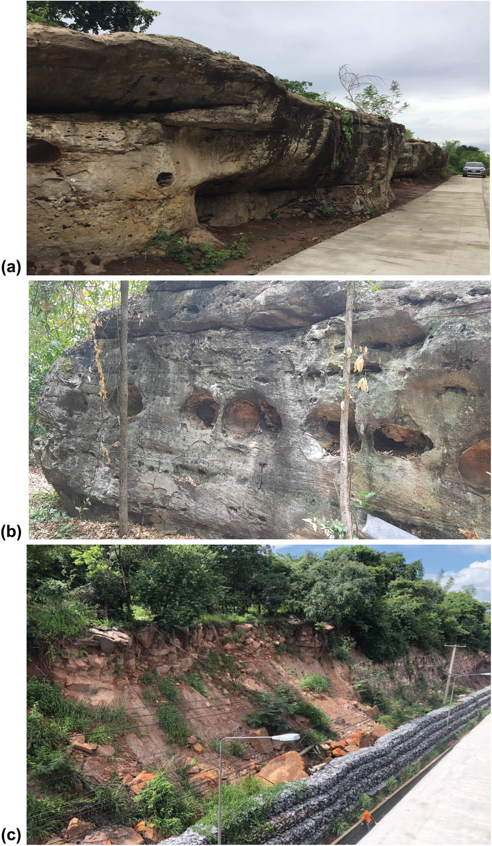
Geomorphic features of the Phra Wihan Formation. (a) and (b) sandstone walls with lateral potholes at Wad Khao Saad locality and (c) rockfall along Highway No.2 (October 2020).
In contrast, landslides or mass wasting are notably absent in the Khorat Cuesta, despite its prominent steep escarpments and dip slopes. While minor rockfalls have been observed along Highway No. 2 (locality C in Figures 16 and 18c), mainly at the lithologic contact between the Phra Wihan and Phu Kradung Formations. No large-scale slope failures or landslide scars were detected during the wet seasons between 2017 and 2024 (Figure 19). This finding is supported by landslide detection models employing the differential bare soil index (dBSI) in combination with slope filtering [89,90]. The model defines slope failure zones as areas with gradients exceeding 10 degrees and deposition zones as areas with slopes below 10 degrees [90]. The dBSI is calculated by subtracting pre-event bare soil index (BSI) values by post-event values, capturing the spectral response associated with changes in bare soil cover. Areas affected by landslide scars or surface exposure are characterized by negative dBSI values, typically visualized in red polygons (Figure 19). Based on these results, no landslide activity was detected on the escarpment or adjacent steep slopes. However, in the event of prolonged heavy rainfall 3–4 days and exceeding 400 mm, landslides may be potentially initiated in strongly weathered sandstone. Such failures are often associated with well-developed joints, dense cracking, fractures, and separation planes that intersect slope faces or mountain flanks [91,92]. The minor rockfalls observed are likely attributable to contrasts in hydraulic conductivity between the two formations, particularly at location C in Figure 16, and as illustrated in Figure 18c.
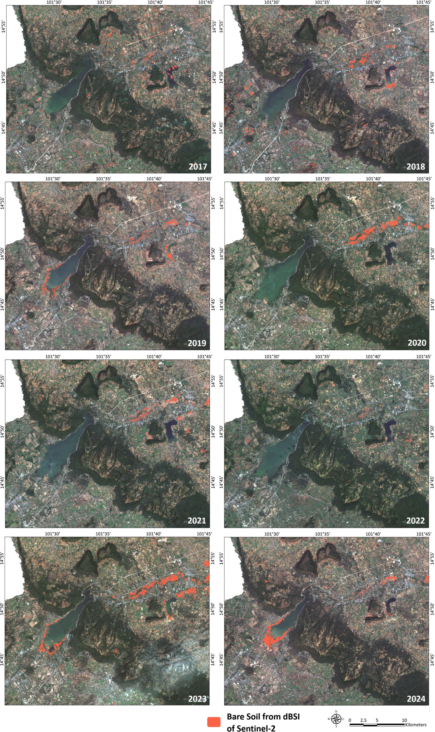
Spatial and temporal distribution of landslide scars on Khorat cuesta from 2017 to 2024.
The strike valley, between 250–330 m a.s.l., lies within the Sao Khua Formation, which is typically regarded as a weak and easily erodible unit. However, our data show that Sao Khua sandstones have higher compressive strength and slake durability than those of the Phra Wihan and Phu Phan Formations. Despite this, chemical weathering – especially dissolution of calcite – plays a significant role in weakening the formation over time, facilitating sediment transport by fluvial processes. Streams within the Sao Khua Formation drain northeast and southeast, eventually merging with the Lam Takong and Lam Phra Pleang Rivers (Figure 16).
The inner cuesta, formed from the Phu Phan Formation, is characterized by dissected hills and mesa-like landforms (Figure 16), generally lower and narrower than the outer cuesta, with less-developed dip streams. The higher rate of weathering and erosion in this unit is attributed to the physical heterogeneity of the conglomeratic sandstones and pebbly conglomerates, which were deposited in high-energy fluvial environments. Poorly sorted gravels may be dislodged, acting as abrasive agents that intensify mechanical breakdown. Several geosites within the Khorat UNESCO Geopark preserve potholes within the Phu Phan Formation, including the Si Khio Stone Quarry – a Khmer-era site at location D (Figure 16), as illustrated in Figure 20a. These 2–3-meter-wide potholes are intersected by NE–SW joints aligned with Cenozoic regional lineaments [36], indicating that they likely formed in paleochannels prior to the plateau’s deformation. Moreover, hilltop potholes recently discovered at ∼350 m a.s.l. at Pha Sam Sip Sang (location E in Figure 16; Figure 20b) are interpreted as indicators of ongoing mechanical weathering, contributing to the progressive degradation of the Phu Phan Formation in exposed areas [93].
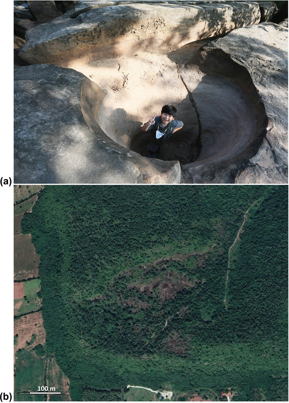
Potholes in the Phu Phan formation. (a) Fluvial pothole of the ancient stream at Si Khui stone quarry. (b) Hilltop potholes on the Pha Sam Sip Sang hill.
The evolution of the Khorat Cuesta appears to differ markedly from comparable landforms elsewhere. For instance, Ward [7] attributed the development of strike valleys in the Coal Cliff Cuesta, Utah, USA, to incision rates and tectonic uplift – a model unsuitable for northeastern Thailand, where tectonic activity has long been dormant. Similarly, the framework proposed by Abe et al. [94], which emphasizes landslides and translational failures, is not applicable, as such processes are absent in the Khorat Cuesta. Instead, our findings support the view that cuesta development is primarily governed by different weathering processes acting on sedimentary strata with contrasting properties. In the Khorat Cuesta, mechanical weathering dominates the Phra Wihan and Phu Phan Formations, while chemical weathering – particularly acid dissolution of calcite – affects the Sao Khua Formation. This might be influenced by Cenozoic volcanic activity in nearby regions, which may have led to acidic atmospheric conditions. Volcanic events of regional significance, including 20–11 Ma eruptions in Lam Narai–Chaibadan (central Thailand); 11.03–8.82 Ma events in Wichian Buri; 3.28–0.92 Ma events along the southern Khorat Plateau margin are recorded [95]. These events may have generated acidic rainfall, accelerated chemical weathering processes, and enhanced the development of the parallel valley system associated with the Sao Khua Formation.
6 Conclusion
This study provides new insights into the role of rock properties in shaping the geomorphological evolution of the Khorat Cuesta within the Khorat UNESCO Global Geopark. Through integrated field observations, petrographic analyses, mechanical testing, and geomorphological interpretation, we demonstrate that the physical, chemical, and mechanical characteristics of sandstones from the Phra Wihan, Sao Khua, and Phu Phan Formations exert a critical influence on cuesta development. Contrary to common assumptions, quartz-rich sandstones are not necessarily the most resistant; rather, durability is strongly controlled by grain size, density, and cement composition, particularly the presence of calcite.
Our results show that the Phra Wihan and Phu Phan sandstones, despite forming high-relief escarpments, are mechanically weaker and less durable than the Sao Khua sandstones. The Phra Wihan sandstones are prone to mechanical weathering processes such as hydraulic action and abrasion, which generate distinctive geomorphic features including pedestal rocks, caves, and joint-controlled blocks. The Phu Phan sandstones, with their conglomeratic textures and poor sorting, are especially vulnerable to disintegration, with clasts acting as abrasive agents that accelerate erosion. In contrast, the Sao Khua sandstones and calcrete horizons, strengthened by calcite cement, display greater mechanical resistance but are susceptible to long-term chemical weathering and dissolution, particularly under acidic conditions. These findings explain the contrasting geomorphic expression of the outer and inner cuestas and highlight the importance of lithological heterogeneity in cuesta evolution.
The evolution of the Khorat Cuesta also differs from comparable cuesta systems worldwide. Models emphasizing tectonic uplift and incision, as in the Coal Cliff Cuesta of Utah, or slope failure processes, as proposed by Abe et al., are not applicable to northeastern Thailand due to its tectonic dormancy and absence of large-scale landslides. Instead, the Khorat Cuesta represents a case where differential weathering of sedimentary strata with contrasting properties plays the dominant role. The combined influence of mechanical breakdown in the Phra Wihan and Phu Phan Formations, and chemical dissolution in the Sao Khua Formation, has shaped the present cuesta morphology. Regional Cenozoic volcanism may have further enhanced these processes by generating acidic rainfall that accelerated chemical weathering.
While this study demonstrates the significance of rock control on geomorphology, it also highlights several limitations. The number of sampled localities was constrained by dense vegetation and restricted access to protected areas, limiting spatial coverage of certain lithologies. Laboratory tests, though extended beyond conventional cycles, still represent simplified simulations of long-term weathering under natural conditions. Moreover, the potential influence of microstructural features such as pore connectivity and microfractures, which may substantially affect rock weakening, was not fully explored here.
Future research should aim to expand the spatial coverage of sampling and apply advanced analytical techniques, such as X-ray microtomography and geochemical modelling, to better characterize the microstructural and chemical drivers of weathering. Long-term monitoring of cuesta slopes under varying climatic conditions would also provide valuable insights into present-day erosional dynamics. Importantly, linking these findings to geosite interpretation will enhance the geotourism value of the Khorat Geopark, by integrating scientific knowledge of landscape evolution into educational resources and visitor experiences. Such integration will not only deepen understanding of the Khorat Cuesta’s uniqueness but also strengthen the role of geoscience in sustainable conservation and geopark management.
Acknowledgments
The authors gratefully acknowledge the Synchrotron Light Research Institute (Public Organization) for partial funding support under grant numbers R12-62 and R07-63. We also thank the Center of Scientific and Technological Equipment, Suranaree University of Technology, for providing laboratory facilities, analytical instruments, and technical assistance during sample preparation and testing. Furthermore, NASA and USGS are acknowledged for accessing the SRTM V3 DEM data to utilize the topographic analysis.
-
Funding information: This research was partially supported by the Synchrotron Light Research Institute (Public Organization) grant numbers R12-62 and R07-63 and Suranaree University of Technology. The funding agencies had no role in the study design, data collection, analysis, interpretation, manuscript writing, or publication decisions.
-
Author contributions: PT conceptualized, designed the mechanical laboratory experiments, conducted formal analyses, and prepared the original draft. SC-S conducted field investigations, designed the chemical laboratory experiments, and contributed to manuscript review. SP contributed to writing the discussion and editing the manuscript. AC supported conceptual development, secured resources, contributed to writing and data visualizations, oversaw manuscript review, editing, and project administration.
-
Conflict of interest: The authors declare no conflict of interest.
-
Data availability statement: The data supporting the findings of this study are available from the corresponding author upon reasonable request.
References
[1] Duszyński F, Migoń P, Strzelecki MC. Escarpment retreat in sedimentary tablelands and cuesta landscapes–Landforms, mechanisms and patterns. Earth Sci Rev. 2019;196:1–42. 10.1016/j.earscirev.2019.102890.Search in Google Scholar
[2] Duszyński F, Migoń P. Sandstone landforms of the High Weald. In: Goudie A, Migoń P, editors. Landscapes and landforms of england and wales. Cham: Springer; 2020 (World Geomorphological Landscapes). 10.1007/978-3-030-38957-4_6.Search in Google Scholar
[3] Duszyński F, Jancewicz K, Migoń P, Waroszewski J, Christl M, Tikhomirov D, et al. Changing rates of escarpment retreat linked to environmental change in a sedimentary tableland, Stołowe Mountains, SW Poland. Geomorphology. 2024;461:109314. 10.1016/j.geomorph.2024.109314.Search in Google Scholar
[4] Young RW, Wray RAL. Contribution to the theory of scarpland development from observations in Central Queensland, Australia. J Geol. 2000;108(6):705–19. 10.1086/317949.Search in Google Scholar
[5] Kleber A. Structure-independent landscape elements in southern Franconian scarplands. Z Geomorphol. 2010;54(3):393–404. 10.1127/0372-8854/2010/0054-0026.Search in Google Scholar
[6] Duszyński F, Migoń P, Kasprzak M. Underground erosion and sand removal from a sandstone tableland, Stołowe Mountains, SW Poland. Catenal. 2016;1–15. 10.1016/j.catena.2016.06.032.Search in Google Scholar
[7] Ward DJ. Dip, layer spacing, and incision rate controls on the formation of strike valleys, cuestas, and cliffbands in heterogeneous stratigraphy. Lithosphere. 2019;11(5):697–707.10.1130/L1056.1Search in Google Scholar
[8] Young RW, Wray RAL. Rock control in sandstone geomorphology: A tribute to Eiju Yatsu with some Australian examples. Z Geomorphol. 2015;59(Suppl.-Bd. 1):3–17.10.1127/zfg_suppl/2015/S-00172Search in Google Scholar
[9] Turkington AV, Paradise TR. Sandstone weathering: A century of research and innovation. Geomorphology. 2005;67:229–53.10.1016/j.geomorph.2004.09.028Search in Google Scholar
[10] Duszyński F, Ford DC, Goudie AS, Migoń P. Rock properties and rock-controlled landforms. Hist Stud Landf Dev Geomorphol. 2022;5(58):151–71. 10.1144/M58-2021-1.Search in Google Scholar
[11] Migoń P, Duszyński F. Landscapes and landforms in coarse clastic sedimentary tablelands – Is there a unifying theme? Catena. 2022;218:1–20. 10.1016/j.catena.2022.106545.Search in Google Scholar
[12] Goudie AS. Quantification of rock control in geomorphology. Earth Sci Rev. 2016;159:374–87.10.1016/j.earscirev.2016.06.012Search in Google Scholar
[13] Wray RAL, Sauro F. An updated global review of solutional weathering processes and forms in quartz sandstones and quartzites. Earth Sci Rev. 2017;171:520–57.10.1016/j.earscirev.2017.06.008Search in Google Scholar
[14] Małgorzat L, Bochen J. Sandstone degradation: An experimental study of accelerated weathering. Env Earth Sci. 2012;67:2027–42.10.1007/s12665-012-1642-ySearch in Google Scholar
[15] Ghobadi MH, Babazadeh R. An investigation on the effect of accelerated weathering on strength and durability of Tertiary sandstones (Qazvin Province, Iran). Env Earth Sci. 2015;73:4237–50. 10.1007/s12665-014-3708-5.Search in Google Scholar
[16] Medini HK, Arbi M. Chemical and physical analysis of sandstone and relationship with weathering damage of Madâin Sâlih monuments. J Taibah Univ Sci. 2018;12(1):37–45. 10.1080/16583655.2018.1451113.Search in Google Scholar
[17] Bruthans J, Filippi M, Schweigstillová J, Řihošek J. Fast evolving conduits in clay-bonded sandstone: Characterization, erosion processes and significance for the origin of sandstone landforms. Geomorphology. 2012;177:178–93.10.1016/j.geomorph.2012.07.028Search in Google Scholar
[18] Bruthans J, Filippi M, Schweigstillová J, Řihošek J. Quantitative study of a rapidly weathering overhang developed in an artificially wetted sandstone cliff. Earth Surf Process Landf. 2017;42:711–23.10.1002/esp.4016Search in Google Scholar
[19] Filippi M, Bruthans J, Řihošek J, Slavík M, Adamovič J, Mašín D. Arcades: Products of stress-controlled and discontinuity-related weathering. Earth Sci Rev. 2018;180:159–84.10.1016/j.earscirev.2018.03.012Search in Google Scholar
[20] Gray M. Geodiversity: The backbone of geoheritage and geoconservation. In Geodiversity: Developing the paradigm. Amsterdam: Elsevier; 2018. p. 13–25. 10.1016/B978-0-12-809531-7.00001-0.Search in Google Scholar
[21] Pérez-Romero ME, Álvarez-García J, Flores-Romero MB, Jiménez-Islas D. UNESCO global geoparks 22 years after their creation: Analysis of scientific production. Land. 2023;12(671):1–18. 10.3390/land12030671.Search in Google Scholar
[22] Burrett C, Udchachon M, Thassanapak H. Palaeozoic correlations and the palaeogeography of the Sibumasu (Shan-Thai) Terrane - A brief review. Res & Knowl. 2016;2(2):1–17. https://ph02.tci-thaijo.org/index.php/stej/article/view/251409/169573.Search in Google Scholar
[23] Duangkrayom J, Jintasakul P, Songtham W, Kruainok P, Naksri W, Thongdee N, et al. Geodiversity in Khorat Geopark, Thailand: Approaches to geoconservation and sustainable development. Int J Geoheritage Park. 2022;10(4):569–96. 10.1016/j.ijgeop.2022.09.003.Search in Google Scholar
[24] Srisanga P, Muangsan N, Choopan T, Thangthong J, Pratcharoenwanich R, Watthana S. Maerua koratensis (Capparaceae), a new species from Thailand. Phytotaxa. 2021;498(3):213–9. 10.11646/phytotaxa.498.3.7.Search in Google Scholar
[25] LaMoreaux PE, Charaljavanaphet J, Jalichan N, Na Chiengmai PP, Bunnag D, Thavisri A, et al. Reconnaissance of the geology and groundwater of the Khorat Plateau, Thailand. Washington: United states Gevernment Printing Office; 1958. https://pubs.usgs.gov/wsp/1429/report.pdf.Search in Google Scholar
[26] Racey A, Goodall JG. Palynology and stratigraphy of the Mesozoic Khorat Group red bed sequences from Thailand. Geol Soc Lond Spec Publ. 2009;315:69–83. 10.1144/SP315.6.Search in Google Scholar
[27] Meesook A. Cretaceous environments of Northeastern Thailand. In: Okada H, Mateer NJ, editors. Cretaceous environments of Asia. Amsterdam: Elsevier; 2000. p. 207–23.10.1016/S0920-5446(00)80034-5Search in Google Scholar
[28] Meesook A. Cretaceous. In: Ridd MF, Barber AJ, Crow MJ, editors. The geology of Thailand. London: The Geological Society of London; 2011. p. 169–84.10.1144/GOTH.8Search in Google Scholar
[29] Meesook A, Saengsrichan W. Jurassic. In: Ridd MF, Barber AJ, Crow MJ, editors. The geology of Thailand. London: The Geological Society of London; 2011. p. 151–68.10.1144/GOTH.7Search in Google Scholar
[30] Meesook A. Jurassic–Cretaceous environment of northeastern Thailand. Technical Report No. GSD 246/2001. Bangkok: Geological Survey Division, Department of Mineral Resources; 2001.Search in Google Scholar
[31] Meesook A, Jingeng S, Teerarungsigul N, Poonpun S. Non-marine Jurassic rocks of Thailand: A summary. Prog Nat Sci. 2006;16:153–62. 10.1080/10020070612330080A.Search in Google Scholar
[32] Booth J, Sattayarak N. Subsurface carboniferous–cretaceous geology of NE Thailand. In: Ridd MF, Barber AJ, Crow MJ, editors. The geology of Thailand. London: The Geological Society of London; 2011. p. 185–222.10.1144/GOTH.9Search in Google Scholar
[33] Morley CK, Charusiri P, Watkinson IM. Structural geology of Thailand during the Cenozoic. Geol Thail. 2011;273–334. 10.1144/GOTH.11.Search in Google Scholar
[34] Charusiri P, Imsamut S, Zhuang Z, Ampaiwan T, Xu X. Paleomagnetism of the earliest Cretaceous to early late Cretaceous sandstones, Khorat Group, Northeast Thailand: Implications for tectonic plate movement of the Indochina Block. Gondwana Res. 2006;9:310–25.10.1016/j.gr.2005.11.006Search in Google Scholar
[35] Veeravinantanakul A, Kanjanapayont P, Sangsompong A, Hasebe N, Charusiri P. Structure of Phu Phan Range in the Khorat Plateau: Its apatite fission track ages and geological syntheses. Bull Earth Sci Thail. 2018;9(1):8–16.Search in Google Scholar
[36] Department of Mineral Resources. The lineament map of Thailand. Technical Report. Geological Survey Section. Bangkok: Department of Mineral Resources; 2015. p. 148.Search in Google Scholar
[37] Parry JTM. The high terrace gravels, Northeast Thailand – A re-evaluation and an integrated theory of their origin. Z Geomorphol. 1996;40(2):145–75.10.1127/zfg/40/1996/145Search in Google Scholar
[38] Ward DE, Bunnag D. Stratigraphy of the Mesozoic Khorat Group in Northeast Thailand. Report of Investigation. 6, Bangkok: Department of Mineral Resources; 1964. p. 95Search in Google Scholar
[39] Department of Mineral Resources. Lexicon of stratigraphic names of Thailand. Geological Standard Division, Bureau of Geological Survey, Department of Mineral Resources; 2013.Search in Google Scholar
[40] Department of Mineral Resources. Geology of Thailand. Bangkok: Department of Mineral Resources; 2007. p. 628 (in Thai).Search in Google Scholar
[41] Jin-Geng S, Meesook A. Non-marine cretaceous bivalve biostratigraphy of Thailand and Southern Lao PDR. In The 2nd Lao-Thai Technical Conference on Geology and Mineral Resources; 2013. p. 17–8. http://library.dmr.go.th/Document/DMR_Technical_Reports/2013/36767.pdf.Search in Google Scholar
[42] Sattayarak N, Srilulwong S, Pum-im S. Petroleum potential of the Triassic pre-Khoray intermontane basin in Northeastern Thailand. In: Thanasuthipitak T, editor. Proceedings of the International Symposium on Intermontane Basins: Geology and Resources. Chiang Mai, Thailand: 1989. p. 43–58.Search in Google Scholar
[43] Racey A. Petroleum geology. In: Ridd MF, Barber AJ, Crow MA, editors. Geology of Thailand. London: Geological Society of London; 2011. p. 251–392.Search in Google Scholar
[44] Racey A, Love MA, Canham AC, Goodall JGS, Polachan S, Jones PD. Stratigraphy and reservoir potential of the Mesozoic Khorat Group, NE Thailand: Part 1, Stratigraphy and sedimentology evolution. J Pet Geol. 1996;19(1):5–40.10.1111/j.1747-5457.1996.tb00511.xSearch in Google Scholar
[45] Sattayarak N. Review of the continental Mesozoic stratigraphy of Thailand. In: Nutalaya P, editor. Proceedings of the Workshop on Stratigraphy of Thailand and Malaysia. Kuala Lumpur, Malaysia; 1983. p. 127–48.Search in Google Scholar
[46] Buffetaut E, Suteethorn V, Martin V, Chaimanee Y, Tong-Buffetaut H. Biostratigraphy of the Mesozoic Khorat Group of Northeastern Thailand: The contribution of vertebrate palaeontology. In: Thanasuthipitak T, editor. Proceedings of the International Symposium on Biostratigraphy of Mainland Southeast Asia: Facies and Palaeontology. Chiang Mai, Thailand: Department of Geological Sciences, Chiang Mai University; 1993. p. 51–62.Search in Google Scholar
[47] Smith PFL, Stokes RB, Briwtow C, Carter A. Mid-Cretaceous inversion in the Northern Khorat Plateau of Lao PDR and Thailand. In: Hall R, Blundell D, editors. Tectonic evolution of Southeast Asia. Geological Society Special Publication No. 106. London: Geological Society of London; 1996. p. 233–47.10.1144/GSL.SP.1996.106.01.15Search in Google Scholar
[48] Cuny G, Suteethorn V, Kamha S, Buffetaut E. Hybodont sharks from the Lower Cretaceous Khok Kruat Formation of Thailand, and hybodont diversity during the Early Cretaceous. Geol Soc Lond Spec Publ. 2008;295:93–107.10.1144/SP295.7Search in Google Scholar
[49] Buffetaut E, Cuny G, Le Loeuff J, Suteethorn V. Late Palaeozoic and Mesozoic continental ecosystems of SE Asia: An introduction. Geol Soc Lond Spec Publ. 2009;315(1):1–5. 10.1144/SP315.1.Search in Google Scholar
[50] Lauprasert K, Cuny G, Thirakhupt K, Suteethorn V. Khoratosuchus jintasakuli gen. et sp. nov., an advanced neosuchian crocodyliform from the Early Cretaceous (Aptian–Albian) of NE Thailand. Geol Soc Lond Spec Publ. 2009;315(1):175–87.10.1144/SP315.13Search in Google Scholar
[51] Kubo T, Shibata M, Naksri W, Jintasakul P, Azuma Y. The earliest record of Asian Eusuchia from the Lower Cretaceous Khok Kruat Formation of Northeastern Thailand. Cretac Res. 2018;82:21–8.10.1016/j.cretres.2017.05.021Search in Google Scholar
[52] Songtham W, Duangkrayom J, Kruainok P, Jenjitpaiboon K. Some geological signatures created by the cuesta formation in Khorat Geopark, NE Thailand. In Symposium on Geological Significance of Khorat Geopark: Khorat Cuesta 2019. Nakhon Ratchasima, Thailand: 2019. p. 10–8.Search in Google Scholar
[53] Chitnarin A, Hanta R, Ketmuangmoon P, Forel MB. Ostracoda (Crustacea) from the Lower Jurassic of northeastern Thailand: stratigraphic and paleoenvironmental implications. Rev de micropaléontologie. 2022;75:100611. 10.1016/j.revmic.2022.100611.Search in Google Scholar
[54] Chitnarin A, Kershaw S, Promduang A, Tepnarong P. Late Triassic freshwater conchostracan, ostracods, and stromatolites from Huai Hin Lat Formation, northeastern Thailand. Thai Geosci J. 2022;3(3):32–50, https://ph03.tci-thaijo.org/index.php/TGJ/article/view/1795.Search in Google Scholar
[55] Saminpanya S, Duangkrayom J, Pratueng J, Hanta R. Petrography, mineralogy and geochemistry of Cretaceous sediment samples from western Khorat Plateau, Thailand, and considerations on their provenance. J Asian Earth Sci. 2014;83:13–34.10.1016/j.jseaes.2014.01.007Search in Google Scholar
[56] Singtuen V, Phajuy B, Anumart A, Charusiri P, Heggemann H. Geochemistry and provenance of Mesozoic sandstones in Khon Kaen Geopark: Implication for tectonics of the western Khorat Plateau of Thailand. PLoS One. 2023;18(4):e0284974. 10.1371/journal.pone.0284974.Search in Google Scholar PubMed PubMed Central
[57] Phienwej N, Singh VK. Engineering properties of rocks of Phu Kradung and Phra Wihan Formations in Northeast Thailand. In Proceedings of the International Conference on Geology, Geotechnology and Mineral Resources of Indochina (GEOINDO 2005). Khon Kaen, Thailand: 2005. p. 199–204.Search in Google Scholar
[58] Fuenkajorn K. Experimental assessment of long-term durability of some weak rocks. Bull Eng Geol Env. 2011;70:203–11.10.1007/s10064-010-0297-8Search in Google Scholar
[59] Walsri C, Sriapai T, Phueakphum D, Fuenkajorn F. Simulation of sandstone degradation using large-scale slake durability index test device. Songklanakarin J Sci Technol. 2012;34(5):587–96.Search in Google Scholar
[60] Torsangtham P, Khamrat S, Thongprapha T, Fuenkajorn K. Laboratory assessment of long-term durability of some decorating and construction rocks. Eng J Res Dev. 2019;30(3):135–43.Search in Google Scholar
[61] Prasujan P, Thongprapha T, Artkhonghan K, Fuenkajorn K. Laboratory simulation of sandstones weathering under cyclic heating and cooling with dry, wet and acidic conditions. J KMUTNB. 2022;32(3):521–9.10.14416/j.kmutnb.2021.12.002Search in Google Scholar
[62] Patanapongsonti S, Sitthimongkol L, Thongprapha T, Fuenkajorn K. Correlation between erosion and energy consumption of sandstones. Eng Appl Sci Res. 2024;54(6):694–703. 10.14456/easr.2024.65.Search in Google Scholar
[63] Department of Mineral Resources. Geological map of Thailand (scale 1:1,000,000). Bangkok: Department of Mineral Resources; 1999.Search in Google Scholar
[64] Nakhon Ratchasima Rajabhat University. Geology and landscapes of Khorat Geopark. Nakhon Ratchasima: 2018. p. 86. https://www.khoratgeopark.com/Data/FileEditor/JO6102-0425%20all.pdf.Search in Google Scholar
[65] Sattayarak N. Development of the so-called Khorat Plateau and Khorat Cuesta. In Proceedings of the Symposium on Geological Significance of Khorat Geopark: Khorat Cuesta 2019. Nakhon Ratchasima, Thailand: 2019. p. 4–5.Search in Google Scholar
[66] Manitkoon S, Suteethorn S, Deesri U, Suteethorn V. An articulated skeleton of the neornithischian dinosaur from the Late Jurassic – Early Cretaceous, Phu Kradung Formation of Thailand. In The 4th International Symposium on Asian Dinosaurs. Ulaanbaatar, Mongolia: 2019. p. 34.Search in Google Scholar
[67] Chowchuvech W, Manitkoon S, Chanthasit P, Ketwetsuriya C. The first occurrence of a basal tyrannosauroid in Southeast Asia: Dental evidence from the Upper Jurassic of Northeastern Thailand. Thai Nat Hist Mus J. 2024;24:84–95. 10.58837/tnh.24.1.261261.Search in Google Scholar
[68] Tucker RT, Hyland EG, Gates TA, King MR, Roberts EM, Foley EK, et al. Age, depositional history, and paleoclimatic setting of Early Cretaceous dinosaur assemblages from the Sao Khua Formation (Khorat Group), Thailand. Palaeogeogr Palaeoclimatol Palaeoecol. 2022;601:111107. 10.1016/j.palaeo.2022.111107.Search in Google Scholar
[69] Buffetaut E, Suteethorn V. The biogeographical significance of the Mesozoic vertebrates from Thailand. In: Hall R, Holloway JD, editors. Biogeography and Geological Evolution of SE Asia. Leiden: Backhuys; 1998. p. 83–90.Search in Google Scholar
[70] Manitkoon S, Deesri U, Warapeang P, Nonsrirach T, Chanthasit P. Ornithischian dinosaurs in Southeast Asia: A review with palaeobiogeographic implications. Foss Rec. 2023;26(1):1–25. 10.3897/fr.26.e93456.Search in Google Scholar
[71] Shibata M, Jintasakul P, Azuma Y. A new iguanodontian dinosaur from the Lower Cretaceous Khok Kruat Formation, Nakhon Ratchasima in Northeastern Thailand. Acta Geol Sin Engl Ed. 2011;85(5):969–76. 10.1111/J.1755-6724.2011.00530.X.Search in Google Scholar
[72] Shibata M, Jintasakul P, Azuma Y, You H-L. A new basal hadrosauroid dinosaur from the Lower Cretaceous Khok Kruat Formation in Nakhon Ratchasima Province, Northeastern Thailand. PLoS One. 2015;10(12):e0145904. 10.1371/journal.pone.0145904.Search in Google Scholar PubMed PubMed Central
[73] ASTM International. ASTM D6473–15: Standard test method for specific gravity and absorption of rock for erosion control. West Conshohocken (PA): ASTM International; 2016.Search in Google Scholar
[74] ASTM International. ASTM D5731–16: Standard test method for determination of the point load strength index of rock and application to rock strength classifications. West Conshohocken (PA): ASTM International; 2016.Search in Google Scholar
[75] ASTM International. ASTM D4644–16: Standard test method for slake durability of shales and other similar weak rocks. West Conshohocken (PA): ASTM International; 2016.Search in Google Scholar
[76] Gamble JC. Durability–plasticity classification of shales and other argillaceous rock. Dissertation. Urbana (IL): University of Illinois; 1971.Search in Google Scholar
[77] Uchida E, Ito K, Shimizu N. Provenance of the sandstone used in the construction of the Khmer monuments in Thailand. Archaeometry. 2009;52(4):550–74. 10.1111/j.1475-4754.2009.00505.x.Search in Google Scholar
[78] Singtuen V, Vivitkul N, Pringproh W. Geology of Hin Chang Si Sandstone Geoheritage in Khon Kaen Province for geotourism planning of Northeastern Thailand. Open J Geol. 2022;12(9):641–7. 10.4236/ojg.2022.129029.Search in Google Scholar
[79] Daorerk V, Charusiri P, Imsamut S, Choowong M. Stratigraphy of dinosaur-bearing Sao Khua, Northeastern Thailand Technical Report; 2002. p. 146.Search in Google Scholar
[80] International Society for Rock Mechanics. Suggested methods for the quantitative description of discontinuities in rock masses (Coordinator, Barton N). Int J Rock Mech Min Sci Geomech Abstr. 1978;15:319–68.Search in Google Scholar
[81] Heidari M, Momeni AA, Rafiei B, Khodabakhsh S, Torabi-Kaveh M. Relationship between petrographic characteristics and the engineering properties of Jurassic sandstones, Hamedan, Iran. Rock Mech Rock Eng. 2013;46(5):1091–101. 10.1007/s00603-012-0333-z.Search in Google Scholar
[82] Alomari EM, Ng KW, Khatri L, Wulff SS. Effect of physical properties on mechanical behaviors of sandstone under uniaxial and triaxial compressions. Materials. 2023;16(13):4867. 10.3390/ma16134867.Search in Google Scholar PubMed PubMed Central
[83] Pappalardo G, Carbone S, Monaco C, Zocco G, Mineo S. Statistical analysis of physico-mechanical parameters of sandstones occurring in orogenic settings. J Mt Sci. 2024;21(4):1388–1402. 10.1007/s11629-023-8497-4.Search in Google Scholar
[84] Song R, Song R, Lifu Z, Wang Y, Liu J. Effects of pore structure on sandstone mechanical properties based on micro-CT reconstruction model. Adv Civ Eng. 2020;2020:1–21. 10.1155/2020/9085045.Search in Google Scholar
[85] Melo MS, de, Giannini PCF. Sandstone dissolution landforms in the Furnas Formation, southern Brazil. Earth Surf Process Landf. 2007;32(14):2149–64. 10.1002/esp.1520.Search in Google Scholar
[86] Lin Y, Lin Y, Zhou K, Li J, Ke B, Gao R. Weakening laws of mechanical properties of sandstone under the effect of chemical corrosion. Rock Mech Rock Eng. 2020;53(4):1857–77. 10.1007/S00603-019-01998-Z.Search in Google Scholar
[87] Chen L, Jia B, Zhang S. Study on mechanical behavior and energy mechanism of sandstone under chemical corrosion. Materials. 2022;15(4):1613. 10.3390/ma15041613.Search in Google Scholar PubMed PubMed Central
[88] Charusiri P, Veeravinatabakul A, Hasebe N, Kanjanapaypnt P. Tectonic settings of the Khorat Geopark, NE Thailand. In Proceedings of the Symposium on Geological Significance of Khorat Geopark: Kharat Cuesta 2019. Nakhon Ratchasima, Thailand: 2019. p. 9.Search in Google Scholar
[89] Ariza A, Davila NA, Kemper H, Kemper G. Landslide detection in Central America using the differential bare soil index. Int Arch Photogramm Remote Sens Spat Inf Sci. 2021;XLIII-B3-2021:679–84. 10.5194/isprs-archives-XLIII-B3-2021-679-2021.Search in Google Scholar
[90] Phakdimek S, Komori D, Chaithong T. Combination of optical images and SAR images for detecting landslide scars, using a classification and regression tree. Int J Remote Sens. 2023;44(11):3572–606. 10.1080/01431161.2023.2224096.Search in Google Scholar
[91] Mori S, Ono K. Landslide disasters in Ehime Prefecture resulting from the July 2018 heavy rain event in Japan. Soils Found. 2019;59(6):2396–2409. 10.1016/j.sandf.2019.11.009.Search in Google Scholar
[92] Phakdimek S, Komori D, Chaithong T, Abe Y. Physically based model for assessing rainfall-induced deep-seated landslides using a hydrological-geotechnical model. Ann GIS. 2025;31(2):1–31. 10.1080/19475683.2025.2481063.Search in Google Scholar
[93] Hanta R. Study of the terrace with potholes at Pha Sam Sip Sang: Evidence of cuesta uplifting in Khorat UNESCO Geopark. Abstract book of the 4th Thailand Geopark Network Symposium 2025: TGN4 2025, Ubon Ratchathani. 19, 2025 (in Thai).Search in Google Scholar
[94] Abe S, Higaki D, Hayashi K. The role of translational landslides in the evolution of cuesta topography. Prog Landslide Res Technol. 2022;1(1):149–61. 10.1007/978-3-031-16898-7_10.Search in Google Scholar
[95] Barr SM, Charusiri O. Volcanic rocks. In: Ridd MF, Barber AJ, Crow MJ, editors. The geology of Thailand. London: The Geological Society of London; 2011. p. 415–40.10.1144/GOTH.15Search in Google Scholar
© 2025 the author(s), published by De Gruyter
This work is licensed under the Creative Commons Attribution 4.0 International License.
Articles in the same Issue
- Research Articles
- Seismic response and damage model analysis of rocky slopes with weak interlayers
- Multi-scenario simulation and eco-environmental effect analysis of “Production–Living–Ecological space” based on PLUS model: A case study of Anyang City
- Remote sensing estimation of chlorophyll content in rape leaves in Weibei dryland region of China
- GIS-based frequency ratio and Shannon entropy modeling for landslide susceptibility mapping: A case study in Kundah Taluk, Nilgiris District, India
- Natural gas origin and accumulation of the Changxing–Feixianguan Formation in the Puguang area, China
- Spatial variations of shear-wave velocity anomaly derived from Love wave ambient noise seismic tomography along Lembang Fault (West Java, Indonesia)
- Evaluation of cumulative rainfall and rainfall event–duration threshold based on triggering and non-triggering rainfalls: Northern Thailand case
- Pixel and region-oriented classification of Sentinel-2 imagery to assess LULC dynamics and their climate impact in Nowshera, Pakistan
- The use of radar-optical remote sensing data and geographic information system–analytical hierarchy process–multicriteria decision analysis techniques for revealing groundwater recharge prospective zones in arid-semi arid lands
- Effect of pore throats on the reservoir quality of tight sandstone: A case study of the Yanchang Formation in the Zhidan area, Ordos Basin
- Hydroelectric simulation of the phreatic water response of mining cracked soil based on microbial solidification
- Spatial-temporal evolution of habitat quality in tropical monsoon climate region based on “pattern–process–quality” – a case study of Cambodia
- Early Permian to Middle Triassic Formation petroleum potentials of Sydney Basin, Australia: A geochemical analysis
- Micro-mechanism analysis of Zhongchuan loess liquefaction disaster induced by Jishishan M6.2 earthquake in 2023
- Prediction method of S-wave velocities in tight sandstone reservoirs – a case study of CO2 geological storage area in Ordos Basin
- Ecological restoration in valley area of semiarid region damaged by shallow buried coal seam mining
- Hydrocarbon-generating characteristics of Xujiahe coal-bearing source rocks in the continuous sedimentary environment of the Southwest Sichuan
- Hazard analysis of future surface displacements on active faults based on the recurrence interval of strong earthquakes
- Structural characterization of the Zalm district, West Saudi Arabia, using aeromagnetic data: An approach for gold mineral exploration
- Research on the variation in the Shields curve of silt initiation
- Reuse of agricultural drainage water and wastewater for crop irrigation in southeastern Algeria
- Assessing the effectiveness of utilizing low-cost inertial measurement unit sensors for producing as-built plans
- Analysis of the formation process of a natural fertilizer in the loess area
- Machine learning methods for landslide mapping studies: A comparative study of SVM and RF algorithms in the Oued Aoulai watershed (Morocco)
- Chemical dissolution and the source of salt efflorescence in weathering of sandstone cultural relics
- Molecular simulation of methane adsorption capacity in transitional shale – a case study of Longtan Formation shale in Southern Sichuan Basin, SW China
- Evolution characteristics of extreme maximum temperature events in Central China and adaptation strategies under different future warming scenarios
- Estimating Bowen ratio in local environment based on satellite imagery
- 3D fusion modeling of multi-scale geological structures based on subdivision-NURBS surfaces and stratigraphic sequence formalization
- Comparative analysis of machine learning algorithms in Google Earth Engine for urban land use dynamics in rapidly urbanizing South Asian cities
- Study on the mechanism of plant root influence on soil properties in expansive soil areas
- Simulation of seismic hazard parameters and earthquakes source mechanisms along the Red Sea rift, western Saudi Arabia
- Tectonics vs sedimentation in foredeep basins: A tale from the Oligo-Miocene Monte Falterona Formation (Northern Apennines, Italy)
- Investigation of landslide areas in Tokat-Almus road between Bakımlı-Almus by the PS-InSAR method (Türkiye)
- Predicting coastal variations in non-storm conditions with machine learning
- Cross-dimensional adaptivity research on a 3D earth observation data cube model
- Geochronology and geochemistry of late Paleozoic volcanic rocks in eastern Inner Mongolia and their geological significance
- Spatial and temporal evolution of land use and habitat quality in arid regions – a case of Northwest China
- Ground-penetrating radar imaging of subsurface karst features controlling water leakage across Wadi Namar dam, south Riyadh, Saudi Arabia
- Rayleigh wave dispersion inversion via modified sine cosine algorithm: Application to Hangzhou, China passive surface wave data
- Fractal insights into permeability control by pore structure in tight sandstone reservoirs, Heshui area, Ordos Basin
- Debris flow hazard characteristic and mitigation in Yusitong Gully, Hengduan Mountainous Region
- Research on community characteristics of vegetation restoration in hilly power engineering based on multi temporal remote sensing technology
- Identification of radial drainage networks based on topographic and geometric features
- Trace elements and melt inclusion in zircon within the Qunji porphyry Cu deposit: Application to the metallogenic potential of the reduced magma-hydrothermal system
- Pore, fracture characteristics and diagenetic evolution of medium-maturity marine shales from the Silurian Longmaxi Formation, NE Sichuan Basin, China
- Study of the earthquakes source parameters, site response, and path attenuation using P and S-waves spectral inversion, Aswan region, south Egypt
- Source of contamination and assessment of potential health risks of potentially toxic metal(loid)s in agricultural soil from Al Lith, Saudi Arabia
- Regional spatiotemporal evolution and influencing factors of rural construction areas in the Nanxi River Basin via GIS
- An efficient network for object detection in scale-imbalanced remote sensing images
- Effect of microscopic pore–throat structure heterogeneity on waterflooding seepage characteristics of tight sandstone reservoirs
- Environmental health risk assessment of Zn, Cd, Pb, Fe, and Co in coastal sediments of the southeastern Gulf of Aqaba
- A modified Hoek–Brown model considering softening effects and its applications
- Evaluation of engineering properties of soil for sustainable urban development
- The spatio-temporal characteristics and influencing factors of sustainable development in China’s provincial areas
- Application of a mixed additive and multiplicative random error model to generate DTM products from LiDAR data
- Gold vein mineralogy and oxygen isotopes of Wadi Abu Khusheiba, Jordan
- Prediction of surface deformation time series in closed mines based on LSTM and optimization algorithms
- 2D–3D Geological features collaborative identification of surrounding rock structural planes in hydraulic adit based on OC-AINet
- Spatiotemporal patterns and drivers of Chl-a in Chinese lakes between 1986 and 2023
- Land use classification through fusion of remote sensing images and multi-source data
- Nexus between renewable energy, technological innovation, and carbon dioxide emissions in Saudi Arabia
- Analysis of the spillover effects of green organic transformation on sustainable development in ethnic regions’ agriculture and animal husbandry
- Factors impacting spatial distribution of black and odorous water bodies in Hebei
- Large-scale shaking table tests on the liquefaction and deformation responses of an ultra-deep overburden
- Impacts of climate change and sea-level rise on the coastal geological environment of Quang Nam province, Vietnam
- Reservoir characterization and exploration potential of shale reservoir near denudation area: A case study of Ordovician–Silurian marine shale, China
- Seismic prediction of Permian volcanic rock reservoirs in Southwest Sichuan Basin
- Application of CBERS-04 IRS data to land surface temperature inversion: A case study based on Minqin arid area
- Geological characteristics and prospecting direction of Sanjiaoding gold mine in Saishiteng area
- Research on the deformation prediction model of surrounding rock based on SSA-VMD-GRU
- Geochronology, geochemical characteristics, and tectonic significance of the granites, Menghewula, Southern Great Xing’an range
- Hazard classification of active faults in Yunnan base on probabilistic seismic hazard assessment
- Characteristics analysis of hydrate reservoirs with different geological structures developed by vertical well depressurization
- Estimating the travel distance of channelized rock avalanches using genetic programming method
- Landscape preferences of hikers in Three Parallel Rivers Region and its adjacent regions by content analysis of user-generated photography
- New age constraints of the LGM onset in the Bohemian Forest – Central Europe
- Characteristics of geological evolution based on the multifractal singularity theory: A case study of Heyu granite and Mesozoic tectonics
- Soil water content and longitudinal microbiota distribution in disturbed areas of tower foundations of power transmission and transformation projects
- Oil accumulation process of the Kongdian reservoir in the deep subsag zone of the Cangdong Sag, Bohai Bay Basin, China
- Investigation of velocity profile in rock–ice avalanche by particle image velocimetry measurement
- Optimizing 3D seismic survey geometries using ray tracing and illumination modeling: A case study from Penobscot field
- Sedimentology of the Phra That and Pha Daeng Formations: A preliminary evaluation of geological CO2 storage potential in the Lampang Basin, Thailand
- Improved classification algorithm for hyperspectral remote sensing images based on the hybrid spectral network model
- Map analysis of soil erodibility rates and gully erosion sites in Anambra State, South Eastern Nigeria
- Identification and driving mechanism of land use conflict in China’s South-North transition zone: A case study of Huaihe River Basin
- Evaluation of the impact of land-use change on earthquake risk distribution in different periods: An empirical analysis from Sichuan Province
- A test site case study on the long-term behavior of geotextile tubes
- An experimental investigation into carbon dioxide flooding and rock dissolution in low-permeability reservoirs of the South China Sea
- Detection and semi-quantitative analysis of naphthenic acids in coal and gangue from mining areas in China
- Comparative effects of olivine and sand on KOH-treated clayey soil
- YOLO-MC: An algorithm for early forest fire recognition based on drone image
- Earthquake building damage classification based on full suite of Sentinel-1 features
- Potential landslide detection and influencing factors analysis in the upper Yellow River based on SBAS-InSAR technology
- Assessing green area changes in Najran City, Saudi Arabia (2013–2022) using hybrid deep learning techniques
- An advanced approach integrating methods to estimate hydraulic conductivity of different soil types supported by a machine learning model
- Hybrid methods for land use and land cover classification using remote sensing and combined spectral feature extraction: A case study of Najran City, KSA
- Streamlining digital elevation model construction from historical aerial photographs: The impact of reference elevation data on spatial accuracy
- Analysis of urban expansion patterns in the Yangtze River Delta based on the fusion impervious surfaces dataset
- A metaverse-based visual analysis approach for 3D reservoir models
- Late Quaternary record of 100 ka depositional cycles on the Larache shelf (NW Morocco)
- Integrated well-seismic analysis of sedimentary facies distribution: A case study from the Mesoproterozoic, Ordos Basin, China
- Study on the spatial equilibrium of cultural and tourism resources in Macao, China
- Urban road surface condition detecting and integrating based on the mobile sensing framework with multi-modal sensors
- Application of improved sine cosine algorithm with chaotic mapping and novel updating methods for joint inversion of resistivity and surface wave data
- The synergistic use of AHP and GIS to assess factors driving forest fire potential in a peat swamp forest in Thailand
- Dynamic response analysis and comprehensive evaluation of cement-improved aeolian sand roadbed
- Rock control on evolution of Khorat Cuesta, Khorat UNESCO Geopark, Northeastern Thailand
- Gradient response mechanism of carbon storage: Spatiotemporal analysis of economic-ecological dimensions based on hybrid machine learning
- Comparison of several seismic active earth pressure calculation methods for retaining structures
- Mantle dynamics and petrogenesis of Gomer basalts in the Northwestern Ethiopia: A geochemical perspective
- Study on ground deformation monitoring in Xiong’an New Area from 2021 to 2023 based on DS-InSAR
- Paleoenvironmental characteristics of continental shale and its significance to organic matter enrichment: Taking the fifth member of Xujiahe Formation in Tianfu area of Sichuan Basin as an example
- Equipping the integral approach with generalized least squares to reconstruct relict channel profile and its usage in the Shanxi Rift, northern China
- InSAR-driven landslide hazard assessment along highways in hilly regions: A case-based validation approach
- Attribution analysis of multi-temporal scale surface streamflow changes in the Ganjiang River based on a multi-temporal Budyko framework
- Maps analysis of Najran City, Saudi Arabia to enhance agricultural development using hybrid system of ANN and multi-CNN models
- Hybrid deep learning with a random forest system for sustainable agricultural land cover classification using DEM in Najran, Saudi Arabia
- Long-term evolution patterns of groundwater depth and lagged response to precipitation in a complex aquifer system: Insights from Huaibei Region, China
- Remote sensing and machine learning for lithology and mineral detection in NW, Pakistan
- Spatial–temporal variations of NO2 pollution in Shandong Province based on Sentinel-5P satellite data and influencing factors
- Numerical modeling of geothermal energy piles with sensitivity and parameter variation analysis of a case study
- Stability analysis of valley-type upstream tailings dams using a 3D model
- Variation characteristics and attribution analysis of actual evaporation at monthly time scale from 1982 to 2019 in Jialing River Basin, China
- Investigating machine learning and statistical approaches for landslide susceptibility mapping in Minfeng County, Xinjiang
- Investigating spatiotemporal patterns for comprehensive accessibility of service facilities by location-based service data in Nanjing (2016–2022)
- A pre-treatment method for particle size analysis of fine-grained sedimentary rocks, Bohai Bay Basin, China
- Study on the formation mechanism of the hard-shell layer of liquefied silty soil
- Comprehensive analysis of agricultural CEE: Efficiency assessment, mechanism identification, and policy response – A case study of Anhui Province
- Simulation study on the damage and failure mechanism of the surrounding rock in sanded dolomite tunnels
- Towards carbon neutrality: Spatiotemporal evolution and key influences on agricultural ecological efficiency in Northwest China
- High-frequency cycles drive the cyclical enrichment of oil in porous carbonate reservoirs: A case study of the Khasib Formation in E Oilfield, Mesopotamian Basin, Iraq
- Reconstruction of digital core models of granular rocks using mathematical morphology
- Spatial–temporal differentiation law of habitat quality and its driving mechanism in the typical plateau areas of the Loess Plateau in the recent 30 years
- A machine-learning-based approach to predict potential oil sites: Conceptual framework and experimental evaluation
- Effects of landscape pattern change on waterbird diversity in Xianghai Nature Reserve
- Research on intelligent classification method of highway tunnel surrounding rock classification based on parameters while drilling
- River morphology and tectono-sedimentary analysis of a shallow river delta: A case study of Putaohua oil layer in Saertu oilfield (L. Cretaceous), China
- Review Articles
- Humic substances influence on the distribution of dissolved iron in seawater: A review of electrochemical methods and other techniques
- Applications of physics-informed neural networks in geosciences: From basic seismology to comprehensive environmental studies
- Ore-controlling structures of granite-related uranium deposits in South China: A review
- Shallow geological structure features in Balikpapan Bay East Kalimantan Province – Indonesia
- A review on the tectonic affinity of microcontinents and evolution of the Proto-Tethys Ocean in Northeastern Tibet
- Advancements in machine learning applications for mineral prospecting and geophysical inversion: A review
- Special Issue: Natural Resources and Environmental Risks: Towards a Sustainable Future - Part II
- Depopulation in the Visok micro-region: Toward demographic and economic revitalization
- Special Issue: Geospatial and Environmental Dynamics - Part II
- Advancing urban sustainability: Applying GIS technologies to assess SDG indicators – a case study of Podgorica (Montenegro)
- Spatiotemporal and trend analysis of common cancers in men in Central Serbia (1999–2021)
- Minerals for the green agenda, implications, stalemates, and alternatives
- Spatiotemporal water quality analysis of Vrana Lake, Croatia
- Functional transformation of settlements in coal exploitation zones: A case study of the municipality of Stanari in Republic of Srpska (Bosnia and Herzegovina)
- Hypertension in AP Vojvodina (Northern Serbia): A spatio-temporal analysis of patients at the Institute for Cardiovascular Diseases of Vojvodina
- Regional patterns in cause-specific mortality in Montenegro, 1991–2019
- Spatio-temporal analysis of flood events using GIS and remote sensing-based approach in the Ukrina River Basin, Bosnia and Herzegovina
- Flash flood susceptibility mapping using LiDAR-Derived DEM and machine learning algorithms: Ljuboviđa case study, Serbia
- Geocultural heritage as a basis for geotourism development: Banjska Monastery, Zvečan (Serbia)
- Assessment of groundwater potential zones using GIS and AHP techniques – A case study of the zone of influence of Kolubara Mining Basin
- Impact of the agri-geographical transformation of rural settlements on the geospatial dynamics of soil erosion intensity in municipalities of Central Serbia
- Where faith meets geomorphology: The cultural and religious significance of geodiversity explored through geospatial technologies
- Applications of local climate zone classification in European cities: A review of in situ and mobile monitoring methods in urban climate studies
- Complex multivariate water quality impact assessment on Krivaja River
- Ionization hotspots near waterfalls in Eastern Serbia’s Stara Planina Mountain
- Shift in landscape use strategies during the transition from the Bronze age to Iron age in Northwest Serbia
- Assessing the geotourism potential of glacial lakes in Plav, Montenegro: A multi-criteria assessment by using the M-GAM model
- Flash flood potential index at national scale: Susceptibility assessment within catchments
- SWAT modelling and MCDM for spatial valuation in small hydropower planning
- Disaster risk perception and local resilience near the “Duboko” landfill: Challenges of governance, management, trust, and environmental communication in Serbia