Ionization hotspots near waterfalls in Eastern Serbia’s Stara Planina Mountain
-
Rastko Marković
 ,
Aleksandar R. Radivojević
,
Aleksandar R. Radivojević

Abstract
This preliminary study examines the seasonal distribution and correlation of negative air ionization near waterfalls situated on two types of geological substrates, and its relationship to water properties such as electrical conductivity (EC), total dissolved solids (TDS), salinity, and water temperature. Measurements were conducted between 2022 and 2024 at six waterfalls in the Stara Planina Mountain. Five waterfalls, Tupavica, Draganov Vir, Tri Kladenca, Donji Piljski, and Grujin, are located on Triassic and Permian sandstones. The sixth, Bigar waterfall, is located on limestone and exhibits characteristics typical of waterfalls formed on carbonate substrates. The results indicate that the underlying geology significantly influences variations in airborne anion concentrations. Waterfalls on sandstone substrates exhibit much higher levels of negative ionization compared to those on limestone. This contrast appears to be linked to water chemistry: sandstone-based waterfalls tend to have lower values of dissolved solids and EC, whereas limestone waterfalls display higher concentrations. These findings contribute to understanding the “waterfall effect” and highlight how geological and environmental factors shape the generation of natural air ionization. Such insights can inform the selection of natural sites for eco-tourism, wellness retreats, and health-oriented infrastructure where exposure to high negative ion concentrations is beneficial.
1 Introduction
The term “air ions” covers all charged particles in the air with electrical mobility. These ions are generally continuously generated by natural sources such as cosmic rays, the radioactive decay of noble gases (such as radon) in the air, and radioactive minerals in the soil [1,2]. Primary ions form ionizations that typically occur within microseconds through a process of hydration and the formation of ion clusters into complexes called small air ions (charged nano-aerosols), which have a typical lifetime of 5–60 s [3]. The central ion of a cluster can include an inorganic molecule and be surrounded by a layer of water molecules. In the aerosols from the waterfalls analyzed in the study by Kolarž et al. [2], such seed nuclei are largely absent in high-purity waters. Air ions are generated by various natural and/or artificial mechanisms. The “waterfall effect” is a phenomenon that mainly generates negative ions, also known as Lenard ions [4]. Philipp Lenard initiated studies on negative ions [4,5], followed by contributions from Chapman [6,7], Blanchard [8], Gathman and Hoppel [9], Levin [10], Reiter [11], Hõrrak et al. [2,12], Hirsikko et al. [13], Laakso et al. [14], Luts et al. [15], Tammet et al. [16], and others. This phenomenon occurs when water droplets hit solid ground, such as in waterfalls or in splashing water waves, which was visually explained and valorized in Laakso et al. [14]. This is the reason why the atmosphere near splashing water can contain up to tens of thousands of negative ions per cubic centimeter. For comparison, on average, there are around 1,000 anions/cm3 in the air near the surface due to cosmic rays and ground radiation [1].
Reiter [11] carried out measurements of ions generated not only by sea spray but also by waterfalls. His results showed that particles smaller than 200 nm originating from sea spray have a positive net charge, while comparable particles from waterfalls are negatively charged. Unlike in rain, where raindrops carry an inherent charge acquired during their formation in clouds, the water in waterfalls is initially electrically neutral.
The waterfall effect has been measured intensively, especially in Northern Europe [14,17]. Most studies relate to the size of airborne particles [14]. The innovation in this study is the correlation between air ionization and water parameters. The primary objective of this study is to investigate the quantitative distribution of negative ions near waterfalls on two types of geological substrates and their relationship with water parameters, including total dissolved solids (TDS), electrical conductivity (EC), and salinity (Salt).
Geochemical analyses of surface and groundwater in Serbia have shown that the mineralization of water depends on the type of geological substrates. The lowest TDS value occurs in metamorphic rocks, it is significantly higher in igneous rocks and the highest in loess and limestone [18]. However, TDS values vary throughout the river sector, as observed on Stara Planina, where red sandstones form bedrock. The amount and mineralization of precipitation are important factors influencing the concentration of dissolved minerals in water, but were not considered in this study. The chemical composition of water depends on the conditions of the environment in which it is formed, i.e., on the correlative effect of the physical-geographical factors of the given area, but also on their intensity [12,19,20,21,22].
Negative air ions benefit human health in many areas, especially the respiratory system, cardiovascular system, and mental health, and can also have an anti-cancer effect [23,24]. Yamada et al. [25] have demonstrated that negative ions generated by water exhibit anti-tumor effects by inhibiting the activity of carcinogens and suppressing tumor growth. Negative air ions affect the cardiovascular system by lowering blood pressure and heart rate [26]. They lower depression levels, improve lung function, and treat asthma symptoms [24]. The therapeutic use of ionized air is recognized in medicine. The intake of various medications, including those for high blood pressure, bronchial asthma, and burns, can lead to negative side effects on the body. Negative air ions can help to “cleanse” the body of people who are chronically exposed to these medications [27]. Negative air ions are effective in removing particulate matter, which in turn leads to an improvement in air quality [28,29]. Due to the numerous benefits they provide, negative air ions are often referred to as “air vitamins” [24,30].
This comprehensive study focuses on understanding the seasonal variations in air ionization levels and their correlation with key water properties in the Stara Planina Mountain and its Visok microregion. The primary aim is to investigate the seasonal distribution of negative air ionization near waterfalls, examining how these levels fluctuate throughout the year. Another key objective is to explore the relationships between maximum air ionization and various geochemical properties of the water, such as EC, TDS, Salt, and water temperature. By analyzing these water parameters, the study seeks to identify any significant patterns or correlations that may influence ionization levels.
The study also includes a comparative analysis of six waterfalls located in areas with two types of geological formations, including Jurassic and Triassic limestones and Permian and Triassic sandstones. This comparison will help assess how variations in geology impact both water chemistry and air ionization. Unlike studies of atmospheric ionization at the regional or global scale, this work emphasizes the ionization directly near waterfalls, where humidity, turbulence, and splash dynamics create unique ionization conditions. An underexplored factor is geological control: the chemistry of the water, shaped by underlying lithology, may influence both the generation and persistence of negative ions.
The research aims to evaluate the combined influence of seasonal changes and geological composition on the distribution of air ions and the properties of the water, providing a deeper understanding of how these factors interact to shape the natural environment. The findings of this study have significant implications for both tourism and health promotion. The presence of high concentrations of negative air ions, particularly in areas with specific geological formations and high-water flow, suggests that these waterfalls could be promoted as micro-spas or natural wellness destinations. Negative ions are known to have beneficial effects on human health, including improving mood, enhancing respiratory function, and reducing stress. By highlighting these health benefits, Stara Planina’s waterfalls could attract wellness tourism, offering visitors a therapeutic environment for relaxation and rejuvenation.
Furthermore, the study’s identification of unique environmental characteristics provides opportunities for eco-tourism development in the region. By leveraging the region’s natural assets – such as its pristine air, mineral-rich water, and stunning landscapes – tourism initiatives could be designed to foster sustainable engagement with the environment. The creation of protected areas around the waterfalls, with careful management of visitor access and environmental impact, would ensure the preservation of these natural resources while supporting the local economy through eco-friendly tourism ventures.
In essence, the research not only advances scientific knowledge of the natural environment but also opens up avenues for sustainable tourism and health-focused initiatives, making Stara Planina a prime destination for those seeking both relaxation and health benefits.
Building on the existing literature, this study adopts an exploratory approach with the following guiding research questions (RQ):
RQ1: How does geology (sandstone vs limestone) influence negative ion generation?
RQ2: How do seasonal hydrological changes affect ionization?
RQ3: What is the relationship between water chemistry (EC, TDS, Salt) and ionization?
While the study does not aim to provide definitive causal explanations, it is based on the working hypothesis that both seasonality and geological substrate contribute to measurable differences in air ion concentrations near waterfalls, primarily through their influence on water chemistry. The exploratory nature of this research acknowledges the complexity of air–water interactions and the current lack of comprehensive data in this field, thereby highlighting the need for further interdisciplinary investigations.
2 Data and methods
2.1 Study area
The Stara Planina Mountain range lies on the border between the Republic of Serbia and the Republic of Bulgaria. It is part of the larger Balkan Mountain range, which is part of the northern Alpine orogenic system. They enter the territory of the Republic of Serbia from the east, forming the eastern zone of the younger fold mountains. The Stara Planina Nature Park is the area with the best-preserved nature in Serbia, with an exceptional geological landscape characterized mainly by waterfalls [31,32,33]. The Stara Planina Nature Park includes sections of the mountain range in the Serbian municipalities of Zaječar (9,958 ha), Knjaževac (57,968 ha), Pirot (63,194 ha), and Dimitrovgrad (11,099 ha), which together cover an area of 142,219 ha (Figure 1) [34,35]. The ridge of Stara Planina represents the border between Serbia and Bulgaria, which runs a few kilometres south-east of the city of Zaječar over the highest peak Midžor (2,169 m a.s.l.), to the peak Srebrna glava (1,932 m a.s.l.) and further to Bulgaria, to the peak Kom (2,016 m a.s.l.) [35,36].
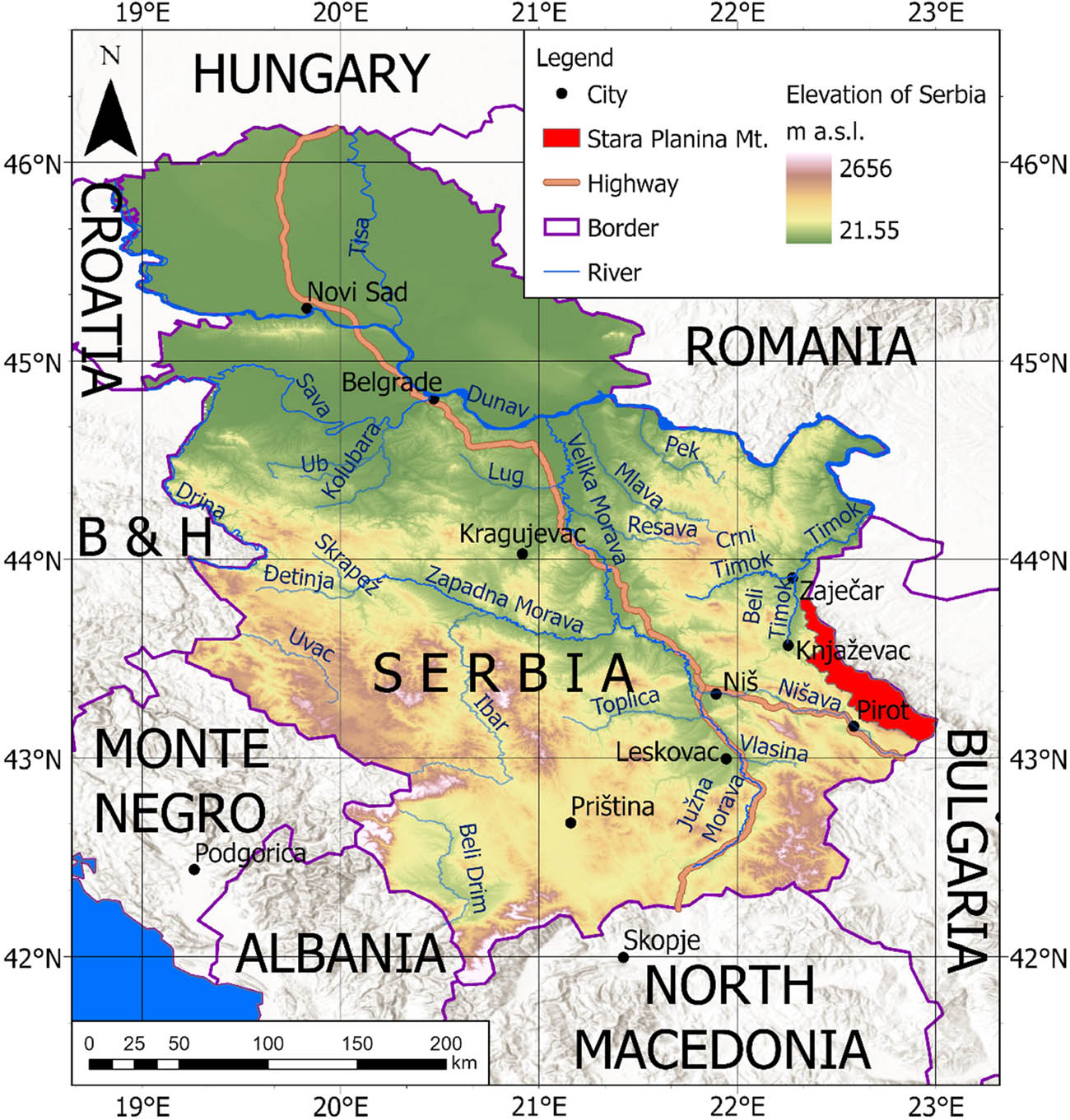
Geographical position of Stara Planina Nature Park.
The microregion Visok is one of four microregions within Stara Planina. It is an integral part of the Eastern Serbia mesoregion, which belongs to the mountain–basin–valley macroregion [37]. Geographically, it is positioned between the Stara Planina and Vidlič Mountains, encompassing the drainage basins of the Visočica and Toplodolska rivers. This area is one of the most geomorphologically and hydrologically intriguing microregions in Serbia. Due to its complex geological, hydrological, and ecological characteristics, Visok represents a unique territorial system. The Visok microregion has about 60 waterfalls, representing most waterfalls of Stara Planina [41]. The total area of Visok spans 710.71 km2, with around 83.4% (approximately 593 km2) located in Serbia and the remaining 16.6% (about 118 km2) in Bulgaria. The Serbian part of Visok includes Pirot and Dimitrovgrad municipalities, placed in the Stara Planina Nature Park. Besides waterfalls, the region’s diverse landscape is characterized by deep gorges, canyons, karstic springs, and pits, a 17 km long Zavoj lake, and many other interesting geomorphological features that contribute to its exceptional natural beauty and ecological value (Figure 2) [32,36].
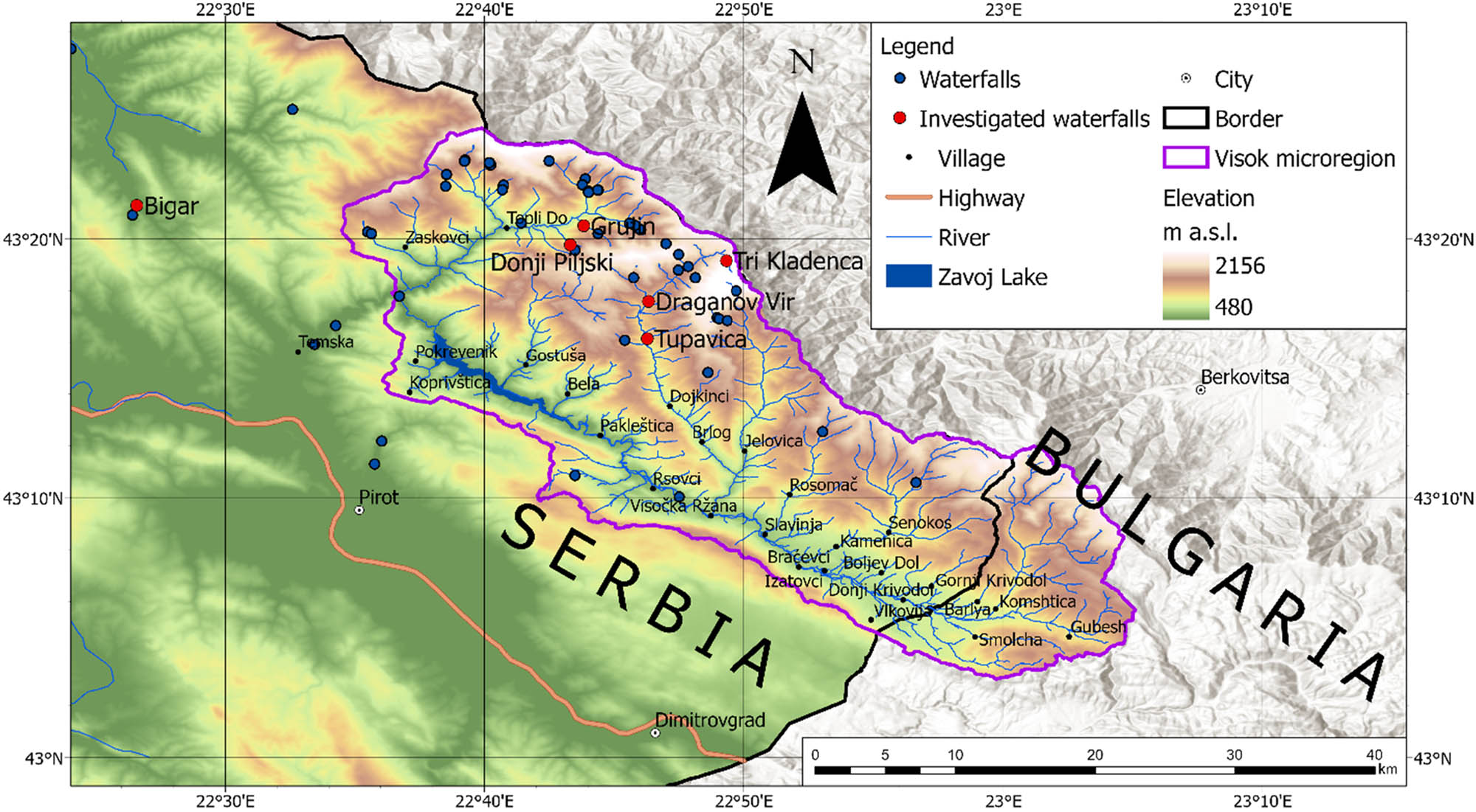
Geographical position of the Visok microregion.
The Stara Planina–Poreč geological unit in eastern Serbia is known for its Permian, Triassic, and Jurassic deposits, which are characterized by their unique palaeontological and sedimentological properties [38]. These deposits, which are mainly found in the southern Stara Planina Mountains, include marine sandstones and shallow marine ramp limestones. This geological phenomenon occurs within the framework of the Eastern Serbian Carpatho–Balkanides, a geological structure that is part of the Dacia mega-unit [39]. The geological subsurface of Stara Planina consists mainly of Mesozoic and Palaeozoic rocks, with red sandstones alternating with silt and clay layers and conglomerates predominating in the Toplodolska River catchment area (Figure 3). Limestone and dolomitic limestone are widespread in the Visočica Basin, while siltstones and clays occur as layers within the Carboniferous rocks [38,39,40].
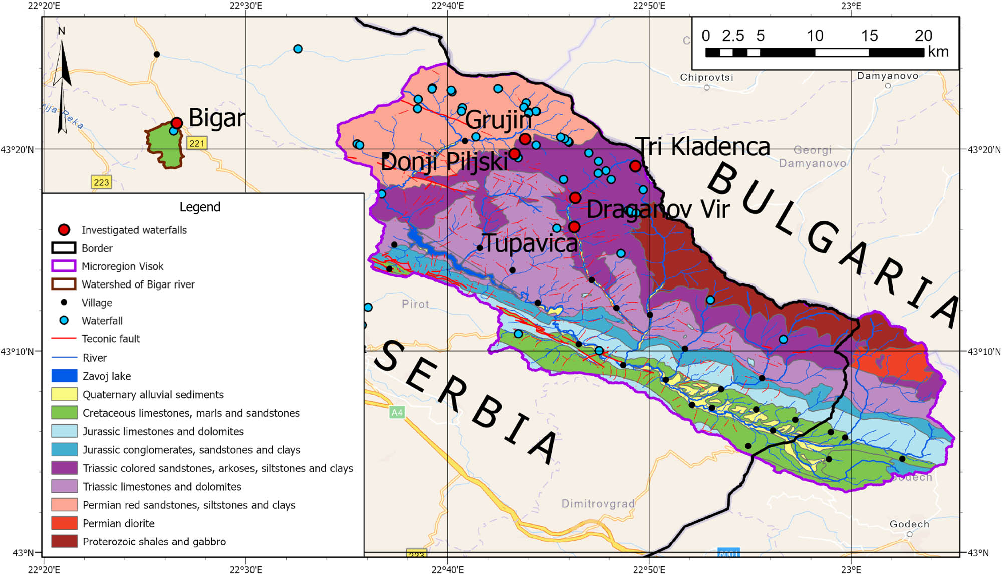
Geological map showing the bedrock beneath the sites of the waterfalls studied.
The climate of the Stara Planina Mountains is specific because it is located in the centre of the Balkan Peninsula, more than 300 km away from all major water bodies: the Adriatic Sea, the Ionian Sea, and the Aegean Sea. However, it is the highest mountain range in eastern Serbia, which makes it wetter than the surrounding areas. Unfortunately, there is no meteorological station in the nature park, but there are some precipitation stations, for example, in Dojkinci and Topli Do villages. However, Marković et al. [40] interpolated the temperatures from the Dimitrovgrad station to the Visočica River catchment area and obtained an average temperature of 7.14°C. The wind was analyzed using the only available data from the nearest station, Dimitrovgrad. The prevailing wind directions are NW and SE, which should be similar for the entire Visok microregion due to the similar orientation of the Stara Planina and Vidlič Mountain ranges. Data from two precipitation stations in Dojkinci and Topli Do were analyzed. In Topli Do, the average annual precipitation for the period from 1949 to 2005 is 790.03 mm, while the average annual precipitation for the Dojkinci station is 808.8 mm for the period from 1946 to 2019 [40,41]. The streams and rivers on the Stara Planina have a pluvio-nival regime with the highest discharge in spring when snowmelt and rain coincide. The best example of this is February 1963, when around 1,950,000 m3 of rocks and soil slid into the Visočica River and formed Lake Zavoj [40,42].
Stara Planina and the microregion Visok are also known for their outstanding waterfalls [31]. With the help of Mapy.com, existing literature, and intensive fieldwork from 2017 to 2024, we registered around 70 waterfalls, which are shown in Figures 2 and 3. For a better understanding of the “waterfall effect,” the ionization of air around six waterfalls was measured during the study period for all seasons: Tupavica, Draganov Vir, Tri Klandenca, Donji Piljski, Grujin, and Bigar waterfalls (Figure 4a–f; Table 1).
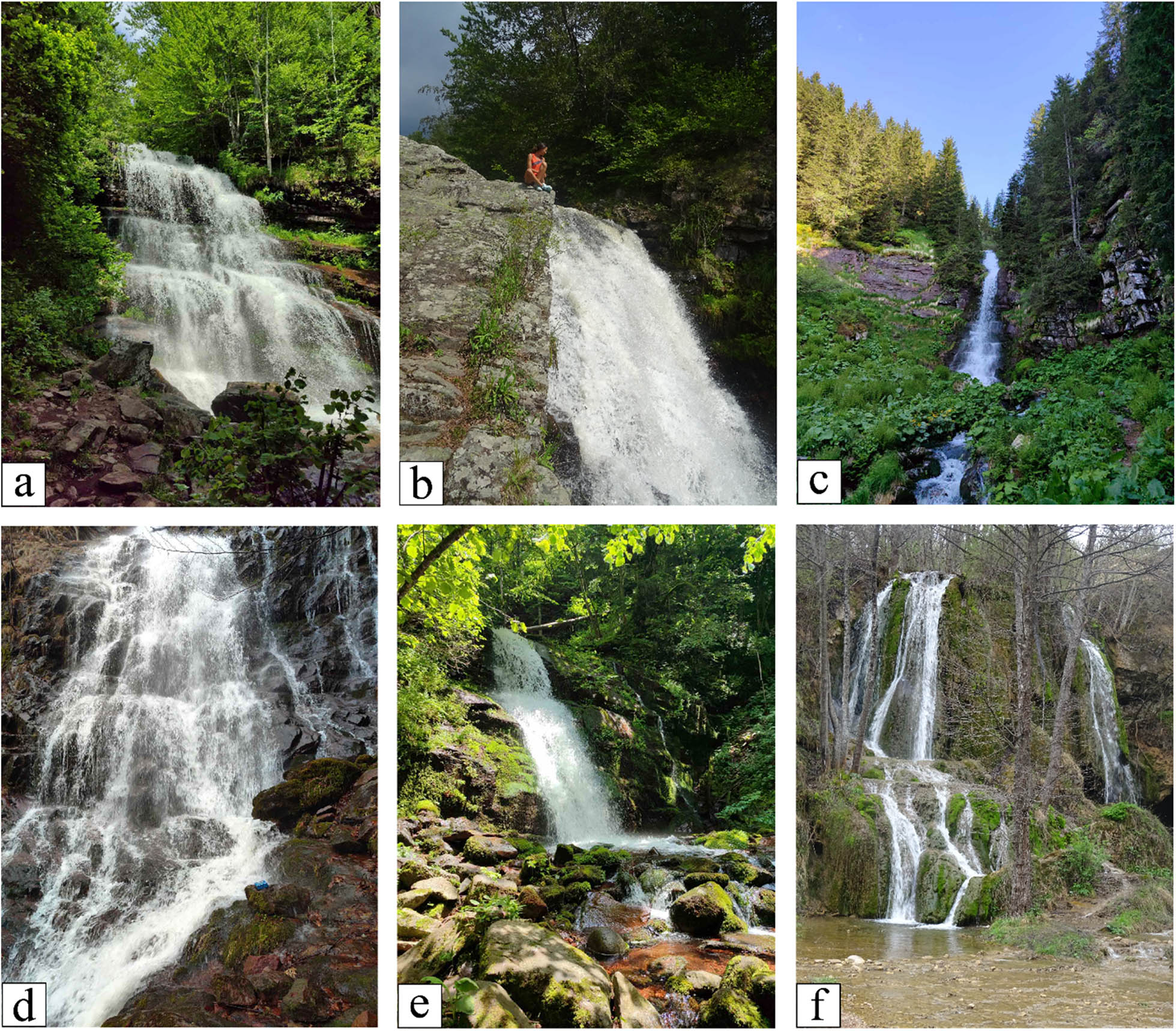
Photos of investigated waterfalls: (a) Tupavica; (b) Draganov Vir; (c) Tri Kladenca; (d) Donji Piljski; (e) Grujin; and (f) Bigar.
Coordinates, altitude, and geological surface of the investigated waterfalls
| Waterfall | Tupavica | Draganov Vir | Tri Kladenca | Donji Piljski | Grujin | Bigar |
|---|---|---|---|---|---|---|
| Longitude | 43.269201 | 43.292798 | 43.319311 | 43.330832 | 43.340033 | 43.354561 |
| Latitude | 22.770960 | 22.771350 | 22.822065 | 22.721397 | 22.728113 | 22.442461 |
| Altitude (m a.s.l.) | 1,050 | 1,143 | 1,750 | 1,181 | 1,175 | 468 |
| Geology | Sandstone | Sandstone | Sandstone | Sandstone | Sandstone | Limestone |
Historically, Stara Planina has remained relatively less visited by tourists in Serbia due to its remote location along the border. Nonetheless, this geographical isolation has played a crucial role in safeguarding its natural and cultural heritage [35]. This region is also known for very intensive depopulation. It had 14,138 inhabitants (without Mala Lukanja and Velika Lukanja, which were submerged after the formation of the Hydropower plant Zavoj) in 1948. Afterwards, in 2022, there were only 504 inhabitants [43,44,45].
2.2 Methodology
Fieldwork took place in the period between the spring of 2022 and the summer of 2024. Data is recorded for all seasons of the year for all six investigated waterfalls. Every time, both air and water parameters were measured. Field measurements were conducted under variable weather conditions and challenging terrain, often requiring walks of more than 20 km. Sampling days were selected based on accessibility and weather rather than randomized scheduling, reflecting natural site conditions.
2.2.1 Ionization of the air
Measurements were carried out using the Onetest-501-II Air Negative Ion Counter at regular intervals of 5 min (Figure 5). The values presented in this study represent the maximum recorded readings from the instrument. These maximum values typically exceeded the average concentration of anions per cm3 by 30–100%. When the maximum value significantly exceeded the average, the measurements were repeated to ensure accuracy and consistency of results. Means could not be obtained because the instrument (Onetest-501-II) does not support automated averaging, and repeated manual measurements were impractical. We therefore reported maximum values, representing the peak potential of the waterfall effect. The device was recalibrated before each campaign per the manufacturer’s instructions.
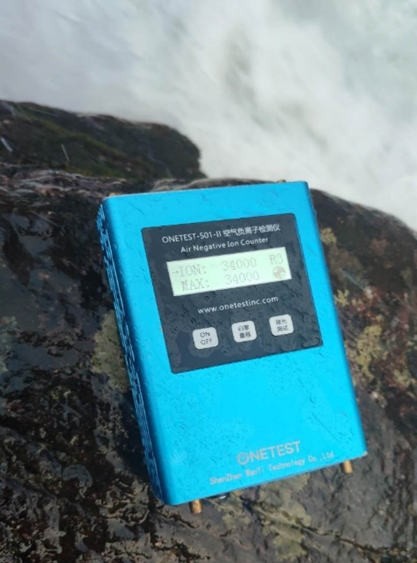
Onetest-501-II air negative ion counter.
Remarkable fluctuations in the concentration of negative air ions were observed during sampling, primarily due to the positioning of the instruments. Small movements in the instrument’s position and changes in its angle relative to the water droplets caused significant variations in the results. Therefore, the device was placed as close as possible to each waterfall, within the limits allowed by the terrain. Additionally, the airflow in the valley where the waterfall is located proved to be an important factor, causing rapid fluctuations in the values under windy conditions.
In some cases, the trajectory of the falling water shifted relative to the flow of the watercourse, a crucial observation as it brought the ionization source closer to the measuring device and thus influenced the results. It is worth noting that the concentration of anions dropped sharply when the device was positioned to the side of the waterfall, while maximum readings were obtained when the device was placed on the rocks within the river flow or near the center of the water descent.
2.2.2 Water properties
The conductivity or EC is the measure of the ability of a liquid to conduct an electrical charge, depending on the concentration of dissolved ions, ionic strength, and temperature of the water. The EC of water depends on water temperature; ions move faster when the water is warmer. So, the conductivity is higher when the water has a higher temperature.
The TDS refer to the combined concentration of inorganic and organic substances in the water. These dissolved substances can include minerals, salts, metals, ions, and other organic compounds. High TDS levels in water can affect its taste, quality, and suitability for various applications such as drinking water, irrigation, and industrial processes. The values of EC and TDS are correlated with each other and determine the overall purity or pollution level of a water sample. They are generally used as water quality parameters.
Salt is the measure of the amount of dissolved salts in the water. Salt is an estimate of the salt content in a water sample and is derived from the conductivity measurement using a conversion factor (usually 0.5). Salt measurements are generally used in agriculture. The concentration of dissolved minerals in water depends on several factors that are determined by natural phenomena and processes. As the amount of water increases, the intensity of chemical decomposition of rocks also increases [18].
The values of these parameters can be easily measured on-site. For this study, we used a portable water quality analyzer, the Quick guide multi-parameter tester 35 (Oakton Instruments, USA) (Figure 6), to measure EC, TDS, Salt, and temperature, providing immediate readings [46].

Quick guide multi-parameter tester 35 (Oakton Instruments, USA).
All the steps, procedures, and approaches used in this study are summarized in the following workflow (Figure 7).
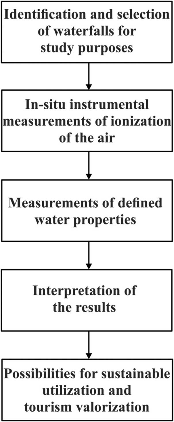
Research workflow.
3 Results and discussion
3.1 Tupavica waterfall
Table 2 shows the results for the Tupavica waterfall. The maximum ionization of the waterfall was measured on June 19, 2023, when the Onetest-501-II instrument reached the maximum value of 2,000,000 anions per cm3. This measurement took place after heavy rainfall in Stara Planina, which may explain this result. Interestingly, the lowest values for EC and TDS were measured on the same day. The second-highest value occurred on March 16, 2024, which is the result of snowmelt. The main reason for the increase in ionization is the increase in water runoff.
Results of negative air ionization and the geochemical properties of the water in the immediate vicinity of the Tupavica waterfall
| Tupavica | R2 (anions/cm3) | R3 (anions/cm3) | Temp. (°C) | EC (ppm) | TDS (ppm) | Salt (ppm) |
|---|---|---|---|---|---|---|
| Date (dd/mm/yyyy) | ||||||
| 12/07/2022 (13:20) | 8,400 | 13,500 | 10.9 | 19.8 | 14.0 | 12.3 |
| 08/08/2022 (10:30) | 40,700 | 13,000 | 15.0 | 23.5 | 16.7 | 15.6 |
| 07/10/2022 (12:15) | 46,400 | 26,000 | 8.2 | 19.2 | 13.6 | 10.6 |
| 31/03/2023 (14:45) | 17,800 | 20,000 | 7.1 | 20.5 | 14.6 | 10.5 |
| 19/06/2023 (14:52) | — | 2,000,000 | 11.3 | 16.3 | 13.2 | 12.2 |
| 16/09/2023 (11:20) | 2,200 | 1,000 | 21.1 | 21.6 | 16.4 | 18.2 |
| 10/12/2023 (11:35) | 45,500 | 47,000 | 1.9 | 22.7 | 16.0 | 7.9 |
| 16/03/2024 (16:30) | — | 201,000 | 5.5 | 20.5 | 14.8 | 9.9 |
The lowest value of air ionization was measured on September 16, 2023. The water discharge was very low after the hot summer period, which can also be concluded from the highest measured water temperature. The water temperatures (September 16, 2023) should not be interpreted as inversely proportional to air ionization. These results are the result of the low discharge values.
3.2 Draganov Vir waterfall
There were three measuring points at the Draganov Vir waterfall. Point A is located at the upper part of the waterfall, point B at the lowest part of the waterfall, and point C on the rock 5 m away from B. Position B is visible on Figure 8. From the results in Table 3, we can conclude that the air with anions circulates downstream and the upper part of the waterfall is characterized by lower air ionization. According to some measurements, the maximum values of ionization were measured only at points B and C.
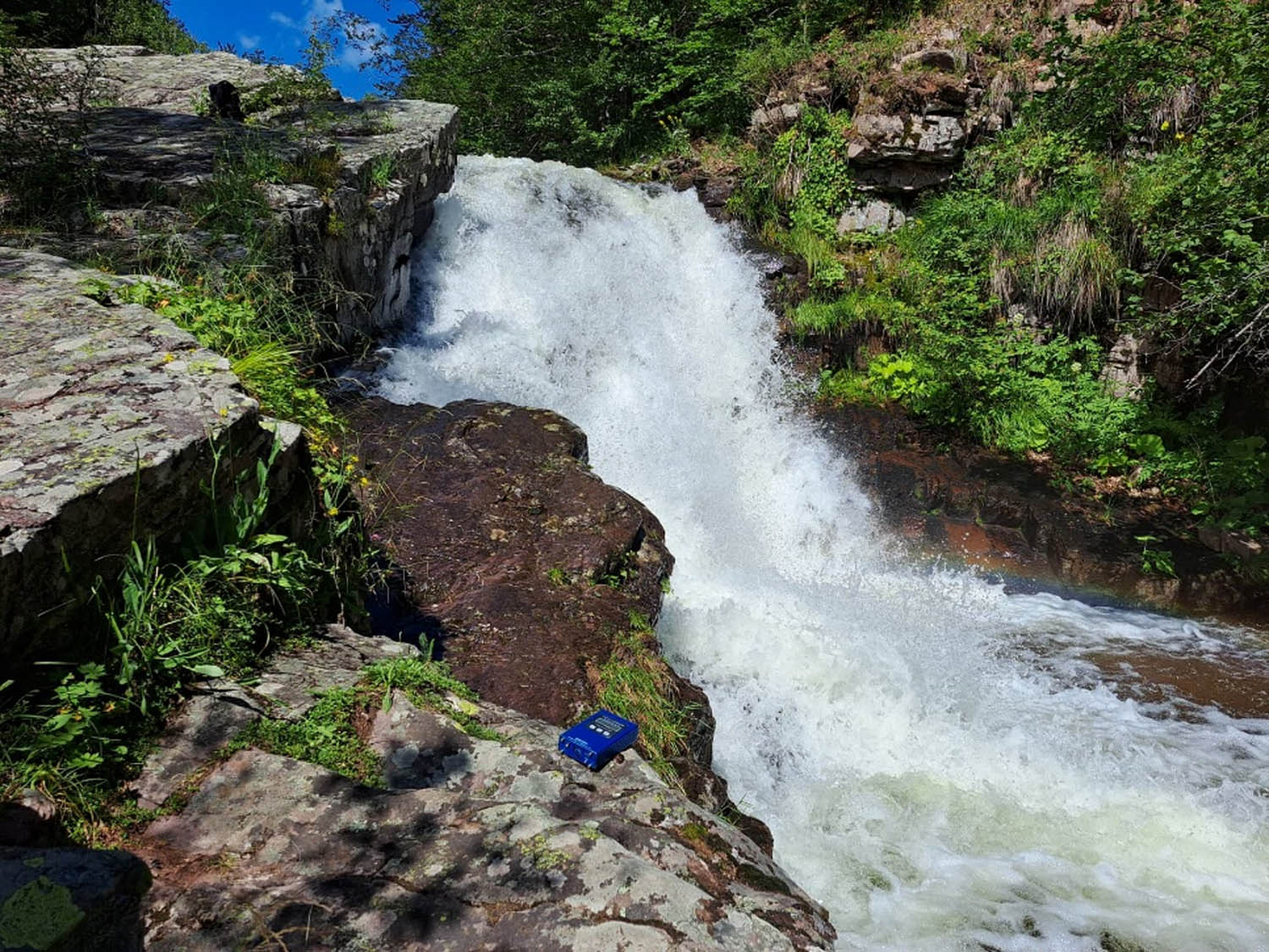
Location of point B at Draganov Vir.
Results of negative air ionization and the geochemical properties of the water in the immediate vicinity of the Draganov Vir waterfall
| Draganov Vir Date (dd/mm/yyyy) | R2 (anions/cm3) | R3 (anions/cm3) | Temp. (°C) | EC (ppm) | TDS (ppm) | Salt (ppm) | ||||
|---|---|---|---|---|---|---|---|---|---|---|
| A | B | C | A | B | C | |||||
| 12/07/2022 (15:00) | 14,900 | 25,800 | 31,200 | 27,000 | 52,000 | 33,000 | 11.0 | 21.0 | 15.0 | 12.8 |
| 08/08/2022 (11:30) | — | 29,800 | — | — | 27,000 | — | 14.8 | 31.3 | 22.3 | 18.7 |
| 07/10/2022 (14:00) | 7,200 | 26,900 | 22,000 | 3,000 | 40,000 | 29,000 | 8.2 | 24.1 | 17.0 | 12.7 |
| 24/12/2022 (15:15) | 3,500 | 30,800 | — | 3,000 | 35,000 | — | 3.7 | 25.6 | 18.3 | 10.6 |
| 31/03/2023 (16:00) | — | 37,700 | 22,800 | — | 35,000 | 18,000 | 5.6 | 23.0 | 16.7 | 11.0 |
| 19/06/2023 (20:00) | — | 36,400 | — | — | 57,000 | — | 10.2 | 20.8 | 14.7 | 12.3 |
| 16/09/2023 (16:50) | — | 8,800 | 21,300 | — | 11,000 | 28,000 | 14.0 | 58.3 | 41.8 | 29.9 |
| 10/12/2023 (13:58) | — | 30,100 | — | — | 38,000 | — | 1.9 | 24.7 | 17.5 | 8.8 |
| 16/03/2024 (17:30) | — | — | — | — | 130,000 | 112,000 | 4.6 | 24.1 | 17.1 | 10.5 |
The maximum value for Draganov Vir is shown on March 16, 2024 (Table 3). Draganov Vir is located on the Dojkinačka River and has the largest catchment area of all the waterfalls analyzed. Therefore, the high discharge of water after the snowmelt influenced this result. The lowest value of ionization is also recorded on September 16, 2023, due to the dry summer period, but due to the large catchment area and water runoff, the ionization of the air is much higher than at Tupavica at the same time.
3.3 Tri Kladenca waterfall
The Tri Kladenca waterfall is the most difficult to access and the highest (1,750 m above sea level), so for safety reasons, there are only four measurements. It has the lowest water mineralization and the lowest water temperature, which is due to its high altitude and small water discharge (Table 4).
Results of negative air ionization and the geochemical properties of the water in the immediate vicinity of the Tri Kladenca waterfall
| Tri Kladenca | R2 (anions/cm3) | R3 (anions/cm3) | Temp. (°C) | EC (ppm) | TDS (ppm) | Salt (ppm) |
|---|---|---|---|---|---|---|
| Date (dd/mm/yyyy) | ||||||
| 12/07/2022 (18:08) | 24,600 | 34,000 | 6.6 | 10.5 | 7.5 | 6.3 |
| 07/10/2022 (18:00) | 28,400 | 31,000 | 5.3 | 10.2 | 7.0 | 5.5 |
| 24/12/2022 (13:00) | 37,800 | 45,000 | 2.7 | 10.8 | 8.0 | 4.0 |
| 19/06/2023 (18:00) | 126,000 | 123,000 | 7.7 | 10.1 | 7.2 | 6.9 |
3.4 Donji Piljski waterfall
Donji Piljski waterfall is one of the most beautiful waterfalls in Stara Planina due to its height and discharge. The maximum value (1,714,000 anions per cm3) was reached on March 2, 2024, after an intensive snowmelt. The water discharge was far above normal, which resulted in all water parameters having the lowest values on that day. On February 11, 2024, we came to a frozen waterfall and the waterfall effect could not be registered because the ice blocked the ion production. Other ionization values were between 8,000 and 48,800 (Table 5) (Figure 9).
Results of negative air ionization and the geochemical properties of the water in the immediate vicinity of the Donji Piljski waterfall
| Donji Piljski | R2 (anions/cm3) | R3 (anions/cm3) | Temp. (°C) | EC (ppm) | TDS (ppm) | Salt (ppm) |
|---|---|---|---|---|---|---|
| Date (dd/mm/yyyy) | ||||||
| 03/08/2022 (15:00) | 18,500 | 8,000 | 16.0 | 46.5 | 33.0 | 25.5 |
| 13/07/2022 (14:21) | 48,800 | 21,000 | 12.7 | 42.0 | 29.7 | 22.3 |
| 15/10/2022 (15:00) | 16,300 | 18,000 | 6.8 | 44.6 | 31.7 | 20.3 |
| 25/12/2022 (13:00) | 26,300 | 27,000 | 3.3 | 34.7 | 24.7 | 13.9 |
| 11/02/2023 (15:00) | 2,800 | 2,000 | 0.0 | 45.5 | 32.4 | 16.6 |
| 29/05/2023 (12:00) | 37,400 | 40,000 | 9.9 | 35.5 | 25.1 | 18.4 |
| 02/03/2024 (13:30) | — | 1,714,000 | 4.3 | 29.0 | 20.5 | 12.3 |
| 19/05/2024 (12:25) | — | 221,000 | 10.1 | 30.9 | 22.2 | 16.5 |
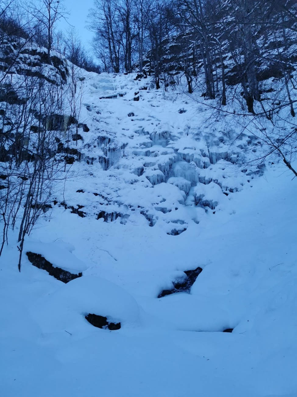
Frozen Donji Piljski waterfall.
3.5 Grujin waterfall
The Grujin waterfall is characterized by two cascades. The original hypothesis was that most of the ions would react in the first cascade and that the production potential would be lower on the second cascade. However, practical results show the opposite. This is due to two factors. The first is the impossibility of placing the instrument in the same place, as a pothole has formed in the riverbed on the upper cascade. For this reason, the instrument was positioned 2 m further away than at the lower cascade. The second reason is the presence of a steeper section at the second cascade. Again, the lowest mineralization values of the water were measured when the highest ionization values were measured (June 22, 2023, and May 19, 2024). The measurements that are not represented by maximum values had a value between 27,100 and 50,600 (Table 6).
Results of negative air ionization and the geochemical properties of the water in the immediate vicinity of the Grujin waterfall
| Grujin waterfall | R2 (anions/cm3) | R3 (anions/cm3) | Temp. (°C) | EC (ppm) | TDS (ppm) | Salt (ppm) | ||
|---|---|---|---|---|---|---|---|---|
| Date (dd/mm/yyyy) | Lower | Upper | Lower | Upper | ||||
| 14/07/2022 (14:50) | 27,100 | 22,100 | 38,000 | 26,000 | 11.7 | 49.8 | 35.4 | 25.1 |
| 15/10/2022 (17:20) | 38,700 | 17,800 | 36,000 | 26,000 | 7.2 | 51.1 | 36.4 | 23.6 |
| 25/12/2022 (15:00) | 50,600 | 37,500 | 46,000 | 32,000 | 4.2 | 46.5 | 32.7 | 19.3 |
| 29/05/2023 (14:45) | 45,100 | — | 40,000 | — | 9.1 | 47.5 | 34.0 | 23.1 |
| 22/06/2023 (13:15) | — | — | 2,000,000 | — | 11.7 | 42.5 | 31.5 | 22.5 |
| 19/05/2024 (14:35) | — | — | 971,000 | — | 9.2 | 42.5 | 30.8 | 21.2 |
3.6 Bigar waterfall
The Bigar waterfall is located on a small stream that lies on limestone rocks. It is the only waterfall that belongs to the Timok basin and not to Temštica. There are about twenty tufa pool deposits above the waterfall, which significantly slow down the flow and facilitate the saturation of the water with calcium carbonate. These conditions resulted in extremely weak air ionization, but rather high values of water parameters (EC, TDS, Salt) (Table 7). This is not only a feature of this waterfall, but also some other tufa waterfalls have similar characteristics, e.g., Kaluđerski do, near Rsovci and Ripaljka, near Sokobanja (Table 8). This was also observed on Blederije near Negotin, but due to no accessible points, it was measured from hand in the water, so the results were not presented.
Results of negative air ionization and the geochemical properties of the water in the immediate vicinity of the Bigar waterfall
| Bigar | R2 (anions/cm3) | R3 (anions/cm3) | Temp. (⁰C) | EC (ppm) | TDS (ppm) | Salt (ppm) |
|---|---|---|---|---|---|---|
| Date (dd/mm/yyyy) | ||||||
| 27/05/2022 (12:40) | 4,100 | 4,000 | 12.9 | 403 | 291 | 189 |
| 05/08/2022 (18:00) | 3,500 | 4,000 | 14.8 | 402 | 289 | 169 |
| 15/10/2022 (12:20) | 2,700 | 2,000 | 10.4 | 393 | 293 | 183 |
| 25/12/2022 (19:45) | 2,000 | 1,000 | 7.0 | 438 | 310 | 191 |
| 11/02/2023 (18:00) | 8,500 | 9,000 | 4.2 | 442 | 319 | 199 |
| 29/05/2023 (19:00) | 0 | 0 | 12.3 | 417 | 296 | 194 |
Results of negative air ionization and the geochemical properties of the water on other tufa waterfalls, with a single measurement
| Tufa waterfalls | Date (dd/mm/yyyy) | R2 (anions/cm3) | R3 (anions/cm3) | Temp. (°C) | EC (ppm) | TDS (ppm) | Salt (ppm) |
|---|---|---|---|---|---|---|---|
| Kaluđerski do | 25/05/2024 (12:00) | 10,200 | 5,000 | 11.3 | 408 | 300 | 197 |
| Ripaljka | 19/08/2023 (12:45) | 22,100 | 15,000 | 15.6 | 473 | 337 | 222 |
It is noteworthy that the highest values of air ionization and water parameters were recorded on February 11, 2023, a pattern not observed at other waterfalls situated on sandstone geology. Given that this waterfall lies at the lowest elevation within the watershed, the earlier onset of snowmelt likely contributes to a significant increase in discharge, influencing the measured values well before the changes are observed at other waterfalls in the study.
3.7 Overall discussion
The analysis clearly shows that the water at the five waterfalls studied is exceptionally clean, characterized by very low values of EC, TDS, and Salt. In contrast, the concentration of negative ions in the air is significantly higher. The Bigar waterfall, however, exhibits the opposite characteristics, with higher water mineralization and lower ionization levels. This distribution of particles in water and air is likely influenced by the geological background, as carbonate rocks dissolve more readily in water (Figure 10 and Table 8).
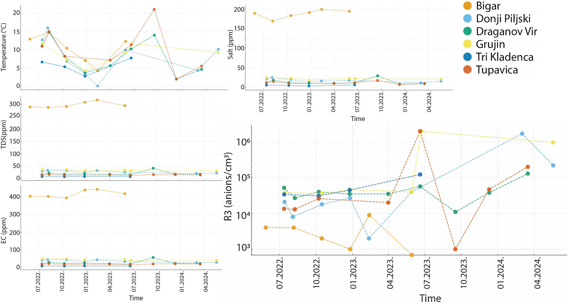
Graphical representation of the study results for all Waterfalls (for Draganov Vir air ionization (R3) represents the Point B; for Grujin air ionization (R3) represents the lower cascade).
Due to the available literature, there are no published studies that directly compare limestone and sandstone waterfalls with respect to negative air ion generation. However, Kolarž et al. [2] conducted a 3-year field campaign in the Austrian Alps, monitoring several waterfalls, most extensively the Krimml and Gartl waterfalls. Their findings indicated that the geological structure of the waterfall plays an important role in determining ion concentration maxima, sometimes even more so than water discharge. They further noted that local topography, water volume, and meteorological conditions interact with geological substrate to shape ion concentration patterns.
Our preliminary results are consistent with these observations: the sandstone-based waterfalls exhibited much higher ionization levels than the limestone-based sites. Although no direct sandstone–limestone comparison has been made globally, our findings strengthen the exploratory evidence that geological substrate is a key factor in the waterfall effect, complementing the results [2]. This underscores both the novelty of our study and the need for broader comparative research across diverse lithologies.
Water temperature is generally proportional to the concentration of negative ions in the air, due to the increased energy potential for ionization. However, the most critical factors influencing ion concentration are the volume of falling water and the height of the waterfall. It is important to note that water temperature fluctuations near the waterfalls in Stara Planina are minimal, meaning that this factor has little impact on the results observed in this study.
Interestingly, water temperature has only a slight influence on ionization levels. One might mistakenly assume that temperature is inversely proportional to the concentration of negative ions, but this is not the case. The primary factor driving the formation of negative ion clouds is the flow or volume of water. In cases where water flow is limited, it tends to heat up more due to the smaller volume, which can reduce ionization. The relationship between water temperature and negative ionization is clearly illustrated in our data from Tupavica waterfall on September 19, 2023, where low flow and higher temperatures had minimal impact on the ion concentrations.
Previous studies on the waterfall effect [13,14,47] have shown a multiple increase in the concentration of negative ions near the waterfall, which was also found in this study. The seasonality of the waterfall effect can be correlated with climatological characteristics, mainly precipitation and snowmelt. The highest potential to produce airborne negatively charged ions is after heavy rains and late winter/early spring snow melts.
The concentration of negative air ions, and thus their impact on health, can vary significantly. For example, in forest air, it may reach up to 5,000 anions per cm3, whereas near waterfalls, it may increase to as much as 10,000 anions per cm3 or more [24]. Except for Bigar Waterfall, where all measurements were below 10,000 anions per cubic centimeter, the other waterfalls studied on Stara Planina Mountain had anion concentrations exceeding 10,000 anions per cm3. Furthermore, at Grujin Waterfall and Tupavica Waterfall, maximum values of 2,000,000 anions per cubic centimeter were recorded. Li et al. [29] identified ion concentration ranges that affect human health, noting that levels above 1,000 anions per cm3 are considered beneficial to human health. Concentrations of negative air ions detected near waterfalls on various geological substrates of Stara Planina Mountain, except Bigar waterfall, exceeded the recommended concentration for health beneficial effect (1,000 anions per cm3) for 10 or even 2,000 times. Due to the prolonged presence of water-generated negative ions in the air and their known health benefits, they warrant further scientific investigation. Moreover, the Stara Planina Mountains offer significant potential for tourism development, particularly from a health and wellness perspective. This research aims to highlight the natural value of Stara Planina, marking the first step towards designating the protective zones around its waterfalls as areas of the highest conservation status, with the possibility of labeling them as micro-spas. The combination of negative ion concentrations and the aesthetic, hygienic, and health-promoting properties of the forests categorizes this region as a prime destination for recreational tourism, which holds considerable importance for its future development. However, such initiatives must be carefully balanced with conservation priorities, as uncontrolled or excessive visitation could place stress on fragile ecosystems. Therefore, any eco-tourism initiatives should be guided by principles of sustainable management, ensuring that tourism growth supports, rather than undermines, long-term conservation goals.
4 Conclusion
This comprehensive study confirms that waterfall-generated negative air ionization is predominantly influenced by water discharge and geological composition, rather than by water temperature or altitude. The results indicate that water mineralization plays a dominant role in air ion generation, being directly linked to geological setting and hydrodynamic conditions. The findings highlight the significant health and ecological value of waterfalls in the Stara Planina region, particularly those associated with silicate geology and high flow rates. These results not only advance scientific understanding of atmospheric ions but also emphasize the practical applications for health tourism and environmental conservation.
Stara Planina Mountain, one of the last remaining natural oases in Serbia, is known for its air quality. Modern research consistently shows that negative air ionization has a positive impact on human health, improving mood, respiratory function, and overall well-being. This study seeks to raise awareness of Stara Planina’s natural assets and represents the first step toward establishing the highest levels of protection for the waterfalls’ surrounding buffer zones, with the goal of designating them as microclimatic zones with potential health benefits.
For waterfalls with multiple cascades, such as the Grujin waterfall, it was found that water mineralization remains largely unchanged (less than 5%) between the upper and lower cascades, suggesting that the water’s splash has a minimal effect on water parameters. Notably, one measurement taken on Donji Piljski Waterfall on February 11, 2023, showed no “waterfall effect,” as the accumulation of ice and snow prevented the water from falling, confirming the need for careful seasonal monitoring. While every effort was made to keep positioning consistent, the terrain and strong water flows occasionally necessitated minor adjustments. This may slightly affect values, but not the overall trends. Future studies will explicitly test distance/angle effects and microclimatic parameters. A valuable direction for long-term future research would be the development of a predictive model based on hydrological, geomorphological, and geological parameters, which could enable estimation of expected ionization levels under varying flow and seasonal conditions.
Given the health-resort, aesthetic, and ecological potential of these waterfalls, it is crucial to implement a protective framework not just for conservation, but also for sustainable usage. This would involve integrating the waterfalls into eco-tourism initiatives, ensuring their long-term viability without compromising the ecological balance. Such an approach would prioritize tourism valorization based on the waterfalls’ ecological and environmental capacities, ensuring that their natural beauty and health benefits can be enjoyed responsibly for future generations.
Acknowledgments
The authors acknowledge the support of the Program of Cooperation with the Serbian Scientific Diaspora – Joint Research Projects – DIASPORA 2023, from the Science Fund of the Republic of Serbia, under the project LAMINATION (The Loess Plateau Margins: Towards Innovative Sustainable Conservation), Project number: 17807. Also, authors are gratefully acknowledging the financial support of the Ministry of Science, Technological Development and Innovation of the Republic of Serbia (grant numbers 451-03-137/2025-03/200124; 451-03-137/2025-03/200125; and 451-03-136/2025-03/200125).
-
Funding information: Authors state no funding involved.
-
Author contributions: Conceptualization and writing original draft preparation: RM, MG, ARR and TL; methodology: RM and MG; fieldwork: RM, DP, PDH, NB and MGB; aspects of negative ionization on health: TPM, TV and IM; touristic value: MM; supervision and mentorship: VS, SBM, ARR and TL. All authors have read and agree to final version of the manuscript.
-
Conflict of interest: Authors state no conflict of interest.
References
[1] Marković LJ. Physics of ionized gases. Niš: Faculty of Sciences and Mathematics; 2004 (in Serbian).Suche in Google Scholar
[2] Kolarž P, Gaisberger M, Madl P, Hofmann W, Ritter M, Hartl A. Characterization of ions at Alpine waterfalls. Atmos Chem Phys. 2012;12(8):3687–97. 10.5194/acp-12-3687-2012.Suche in Google Scholar
[3] Hõrrak U, Salm J, Tammet H. Statistical characterization of air ion mobility spectra at Tahkuse Observatory: Classification of air ions. J Geophys Res Atmos. 2000;105(D7):9291–302. 10.1029/1999JD901197.Suche in Google Scholar
[4] Lenard P. Ueber die Electricität der Wasserfälle. Ann Phys Chem. 1892;282(8):584–636.10.1002/andp.18922820805Suche in Google Scholar
[5] Lenard P. On waterfall electricity and on the surface condition of liquids. Mon Weather Rev. 1915;43(10):509–10.10.1175/1520-0493(1915)43<509:OWEAOT>2.0.CO;2Suche in Google Scholar
[6] Chapman S. Carrier mobility spectra of spray electrified liquids. Phys Rev. 1937;52(3):184–90. 10.1103/PhysRev.52.184.Suche in Google Scholar
[7] Chapman S. Interpretation of carrier mobility spectra of liquids electrified by bubbling and spraying. Phys Rev. 1938;54(7):528–33. 10.1103/PhysRev.54.528.Suche in Google Scholar
[8] Blanchard DC. Electrified droplets from the bursting of bubbles at an air–sea water interface. Nature. 1955;175(4451):334–6. 10.1038/175334a0.Suche in Google Scholar
[9] Gathman SG, Hoppel WA. Electrification processes over Lake Superior. J Geophys Res. 1970;75(6):1041–8. 10.1029/JC075i006p01041.Suche in Google Scholar
[10] Levin Z. Charge separation by splashing of naturally falling raindrops. J Atmos Sci. 1971;28(4):543–8. 10.1175/1520-0469(1971)028%3C0543:CSBSON%3E2.0.CO;2.Suche in Google Scholar
[11] Reiter R. Charges on particles of different size from bubbles of Mediterranean Sea surf and from waterfalls. J Geophys Res Atmos. 1994;99(D5):10807–12. 10.1029/93JD03268.Suche in Google Scholar
[12] Hõrrak U, Tammet H, Aalto PP, Vana M, Hirsikko A, Laakso L, et al. Formation of charged nanometer aerosol particles associated with rainfall: atmospheric measurements and lab experiment. In Proceedings of BACCI, NECC and FcoE activities 2005; 2006. p. 180–6.Suche in Google Scholar
[13] Hirsikko A, Bergman T, Laakso L, Dal Maso M, Riipinen I, Hõrrak U, et al. Identification and classification of the formation of intermediate ions measured in boreal forest. Atmos Chem Phys. 2007;7(1):201–10. 10.5194/acp-7-201-2007.Suche in Google Scholar
[14] Laakso L, Hirsikko A, Grönholm T, Kulmala M, Luts A, Parts TE. Waterfalls as sources of small charged aerosol particles. Atmos Chem Phys. 2007;7(9):2271–5. 10.5194/acp-7-2271-2007.Suche in Google Scholar
[15] Luts A, Parts TE, Laakso L, Hirsikko A, Grönholm T, Kulmala M. Some air electricity phenomena caused by waterfalls: Correlative study of the spectra. Atmos Res. 2009;91(2–4):229–37. 10.1016/j.atmosres.2008.02.019.Suche in Google Scholar
[16] Tammet H, Hõrrak U, Kulmala M. Negatively charged nanoparticles produced by splashing of water. Atmos Chem Phys. 2009;9(2):357–67. 10.5194/acp-9-357-2009.Suche in Google Scholar
[17] Kulmala M, Tammet H. Finnish–Estonian air ion and aerosol workshops. Boreal Environ Res. 2007;12(3):237–45.Suche in Google Scholar
[18] Manojlović P. Chemical erosion as a geomorphological process – theoretical, analytical, and methodological approach. Serbia: Faculty of Geography – Laboratory of Physical Geography; 1992. p. 1–112 (in Serbian).Suche in Google Scholar
[19] Beylich AA, Kolstrup E, Thyrsted T, Gintz D. Water chemistry and its diversity in relation to local factors in the Latnjavagge drainage basin, arctic–oceanic Swedish Lapland. Geomorphology. 2004;58(1–4):125–43. 10.1016/S0169-555X(03)00228-9.Suche in Google Scholar
[20] Dixon JC, Thorn CE. Chemical weathering and landscape development in mid-latitude alpine environments. Geomorphology. 2005;67(1–2):127–45. 10.1016/j.geomorph.2004.07.009.Suche in Google Scholar
[21] Kieu LD, Nguyen PQ. Groundwater quality assessment in the middle-upper pleistocene aquifer. Civ Eng J. 2024;10(7):2357–69. 10.28991/CEJ-2024-010-07-018.Suche in Google Scholar
[22] Pham NQ, Nguyen GT. Evaluating groundwater quality using multivariate statistical analysis and groundwater quality index. Civ Eng J. 2024;10(3):699–713. 10.28991/CEJ-2024-010-03-03.Suche in Google Scholar
[23] Jiang SY, Ma A, Ramachandran S. Negative air ions and their effects on human health and air quality improvement. Int J Mol Sci. 2018;19:2966. 10.3390/ijms19102966.Suche in Google Scholar PubMed PubMed Central
[24] Xiao S, Wei T, Petersen JD, Zhou J, Lu X. Biological effects of negative air ions on human health and integrated multiomics to identify biomarkers: A literature review. Environ Sci Pollut Res. 2023;30(27):69824–36. 10.1007/s11356-023-27133-8.Suche in Google Scholar PubMed PubMed Central
[25] Yamada R, Yanoma S, Akaike M, Tsuburaya A, Sugimasa Y, Takemiya S, et al. Water-generated negative air ions activate NK cells and inhibit carcinogenesis in mice. Cancer Lett. 2006;239:190–7. 10.1016/j.canlet.2005.08.002.Suche in Google Scholar PubMed
[26] Suzuki S, Yanagita S, Amemiya S, Kato Y, Kubota N, Ryushi T, et al. Effects of negative air ions on activity of neural substrates involved in autonomic regulation in rats. Int J Biometeorol. 2008;52(6):481–9. 10.1007/s00484-007-0143-2.Suche in Google Scholar PubMed
[27] Kondrashova MN, Grigorenko EV, Tikhonov AN, Sirota TV, Temnov AV, Stavrovskaja IG, et al. The primary physico-chemical mechanism for the beneficial biological/medical effects of negative air ions. IEEE Trans Plasma Sci. 2000;28(1):230–7. 10.1109/27.842910.Suche in Google Scholar
[28] Yan X, Wang H, Hou Z, Wang Z, Zhang D, Xu Q, et al. Spatial analysis of the ecological effects of negative air ions in urban-vegetated areas: A case study in Maiji, China. Urban Urban Green. 2015;14:636–45. 10.1016/j.ufug.2015.06.010.Suche in Google Scholar
[29] Li A, Li Q, Zhou B, Ge X, Cao Y. Temporal dynamics of negative air ion concentration and its relationship with environmental factors: results from long-term on-site monitoring. Sci Total Environ. 2022;832:155057. 10.1016/j.scitotenv.2022.155057.Suche in Google Scholar PubMed
[30] Ferreira-Pęgo C, Babio N, Maraver Eyzaguirre F, Vitoria Miņana I, Salas-Salvadó J. Water mineralization and its importance for health. Alim Nutri Salud. 2016;23(1):4–18.Suche in Google Scholar
[31] Stojadinović D. Waterfalls of Serbia. Kragujevac: National Library “Vuk Karadžić”; 2013 (in Serbian).Suche in Google Scholar
[32] Marjanović M, Milenković J, Lukić M, Tomić N, Antić A, Marković RS, et al. Geomorphological and hydrological heritage of Mt. Stara Planina in SE Serbia: From river protection initiative to potential geotouristic destination. Open Geosci. 2022;14(1):275–93. 10.1515/geo-2022-0340.Suche in Google Scholar
[33] Marjanović M, Radivojević AR, Antić A, Peppoloni S, Di Capua G, Lazarević J, et al. Geotourism and geoethics as support for rural development in the Knjaževac municipality, Serbia. Open Geosci. 2022;14(1):794–812. 10.1515/geo-2022-0388.Suche in Google Scholar
[34] Mijović D. Park prirode’Stara planina’. Beograd: Zavod za zaštitu prirode; 2006 (in Serbian).Suche in Google Scholar
[35] Stankov U, Stojanović V, Dragićević V, Arsenović D. Ecotourism: An alternative to mass tourism in nature park “Stara planina”. Journal of the Geographical Institute” Jovan Cvijic”. SASA. 2011;61(1):43–59. 10.2298/IJGI1101043S.Suche in Google Scholar
[36] Vidanović G. Visok: Economic-geographical research. Belgrade: Naučna knjiga; 1955 (in Serbian).Suche in Google Scholar
[37] Pavlović M. Geographical regions of Serbia, vol. 2 – Mountain-basin-valley macroregion. Belgrade: University of Belgrade – Faculty of Geography; 2019 (in Serbian).Suche in Google Scholar
[38] Banjac N. Stratigrafija Srbije i Crne Gore. Beograd: Rudarsko-geološki fakultet; 2004 (in Serbian).Suche in Google Scholar
[39] Đaković M, Rabrenović D, Jovanović D, Sudar M, Radonjić M. Biostratigraphy on ammonoids and foraminifers of Middle Triassic (Pelsonian) Jelovica Limestone Formation (Stara Planina Mts), Eastern Serbia. Geol Carpath. 2022;73(3):187–205. 10.31577/GeolCarp.73.3.2.Suche in Google Scholar
[40] Marković R, Mudelsee M, Radaković MG, Radivojević AR, Schaetzl RJ, Basarin B, et al. An index for snowmelt-induced landslide prediction for Zavoj Lake, Serbia. Atmosphere. 2024;15(3):256. 10.3390/atmos15030256.Suche in Google Scholar
[41] Milovanović B. Climate of Stara Planina. Belgrade: Geographical Institute “Jovan Cvijić” of the Serbian Academy of Sciences and Arts (SASA); 2010 (in Serbian).Suche in Google Scholar
[42] Jovanović R. Zavoj – from village to lake. In Zemlja i Ljudi [The Land and People], popular-science collection. Belgrade: Serbian Geographical Society; 2011 (in Serbian).Suche in Google Scholar
[43] Krstić V. The population of southeastern Serbia: A comparative study of demographic development. Niš: Institute of Urban Planning; 2007 (in Serbian).Suche in Google Scholar
[44] Velojić M, Radovanović O. Visok. Zaječar–Bor: Tercija; 2017 (in Serbian).Suche in Google Scholar
[45] Marković K, Radivojević AR, Marković R. Depopulation in the Visok micro-region: Towards demographic and economic revitalization. Open Geosci. 2025;16:20220703. 10.1515/geo-2022-0703.Suche in Google Scholar
[46] Manojlović P, Nikolić M, Mustafić S, Luković J. Seasonal variability of Crvena river water mineralization. Bull Serb Geogr Soc. 2010;90(4):9–27. 10.2298/GSGD1004009M.Suche in Google Scholar
[47] Zhang DD, Peart M, Zhang YJ, Zhu A, Cheng X. Natural water softening processes by waterfall effects in karst areas. Desalination. 2000 Aug;129(3):247–59.10.1016/S0011-9164(00)00065-5Suche in Google Scholar
© 2025 the author(s), published by De Gruyter
This work is licensed under the Creative Commons Attribution 4.0 International License.
Artikel in diesem Heft
- Ionization hotspots near waterfalls in Eastern Serbia’s Stara Planina Mountain
- Research Articles
- Seismic response and damage model analysis of rocky slopes with weak interlayers
- Multi-scenario simulation and eco-environmental effect analysis of “Production–Living–Ecological space” based on PLUS model: A case study of Anyang City
- Remote sensing estimation of chlorophyll content in rape leaves in Weibei dryland region of China
- GIS-based frequency ratio and Shannon entropy modeling for landslide susceptibility mapping: A case study in Kundah Taluk, Nilgiris District, India
- Natural gas origin and accumulation of the Changxing–Feixianguan Formation in the Puguang area, China
- Spatial variations of shear-wave velocity anomaly derived from Love wave ambient noise seismic tomography along Lembang Fault (West Java, Indonesia)
- Evaluation of cumulative rainfall and rainfall event–duration threshold based on triggering and non-triggering rainfalls: Northern Thailand case
- Pixel and region-oriented classification of Sentinel-2 imagery to assess LULC dynamics and their climate impact in Nowshera, Pakistan
- The use of radar-optical remote sensing data and geographic information system–analytical hierarchy process–multicriteria decision analysis techniques for revealing groundwater recharge prospective zones in arid-semi arid lands
- Effect of pore throats on the reservoir quality of tight sandstone: A case study of the Yanchang Formation in the Zhidan area, Ordos Basin
- Hydroelectric simulation of the phreatic water response of mining cracked soil based on microbial solidification
- Spatial-temporal evolution of habitat quality in tropical monsoon climate region based on “pattern–process–quality” – a case study of Cambodia
- Early Permian to Middle Triassic Formation petroleum potentials of Sydney Basin, Australia: A geochemical analysis
- Micro-mechanism analysis of Zhongchuan loess liquefaction disaster induced by Jishishan M6.2 earthquake in 2023
- Prediction method of S-wave velocities in tight sandstone reservoirs – a case study of CO2 geological storage area in Ordos Basin
- Ecological restoration in valley area of semiarid region damaged by shallow buried coal seam mining
- Hydrocarbon-generating characteristics of Xujiahe coal-bearing source rocks in the continuous sedimentary environment of the Southwest Sichuan
- Hazard analysis of future surface displacements on active faults based on the recurrence interval of strong earthquakes
- Structural characterization of the Zalm district, West Saudi Arabia, using aeromagnetic data: An approach for gold mineral exploration
- Research on the variation in the Shields curve of silt initiation
- Reuse of agricultural drainage water and wastewater for crop irrigation in southeastern Algeria
- Assessing the effectiveness of utilizing low-cost inertial measurement unit sensors for producing as-built plans
- Analysis of the formation process of a natural fertilizer in the loess area
- Machine learning methods for landslide mapping studies: A comparative study of SVM and RF algorithms in the Oued Aoulai watershed (Morocco)
- Chemical dissolution and the source of salt efflorescence in weathering of sandstone cultural relics
- Molecular simulation of methane adsorption capacity in transitional shale – a case study of Longtan Formation shale in Southern Sichuan Basin, SW China
- Evolution characteristics of extreme maximum temperature events in Central China and adaptation strategies under different future warming scenarios
- Estimating Bowen ratio in local environment based on satellite imagery
- 3D fusion modeling of multi-scale geological structures based on subdivision-NURBS surfaces and stratigraphic sequence formalization
- Comparative analysis of machine learning algorithms in Google Earth Engine for urban land use dynamics in rapidly urbanizing South Asian cities
- Study on the mechanism of plant root influence on soil properties in expansive soil areas
- Simulation of seismic hazard parameters and earthquakes source mechanisms along the Red Sea rift, western Saudi Arabia
- Tectonics vs sedimentation in foredeep basins: A tale from the Oligo-Miocene Monte Falterona Formation (Northern Apennines, Italy)
- Investigation of landslide areas in Tokat-Almus road between Bakımlı-Almus by the PS-InSAR method (Türkiye)
- Predicting coastal variations in non-storm conditions with machine learning
- Cross-dimensional adaptivity research on a 3D earth observation data cube model
- Geochronology and geochemistry of late Paleozoic volcanic rocks in eastern Inner Mongolia and their geological significance
- Spatial and temporal evolution of land use and habitat quality in arid regions – a case of Northwest China
- Ground-penetrating radar imaging of subsurface karst features controlling water leakage across Wadi Namar dam, south Riyadh, Saudi Arabia
- Rayleigh wave dispersion inversion via modified sine cosine algorithm: Application to Hangzhou, China passive surface wave data
- Fractal insights into permeability control by pore structure in tight sandstone reservoirs, Heshui area, Ordos Basin
- Debris flow hazard characteristic and mitigation in Yusitong Gully, Hengduan Mountainous Region
- Research on community characteristics of vegetation restoration in hilly power engineering based on multi temporal remote sensing technology
- Identification of radial drainage networks based on topographic and geometric features
- Trace elements and melt inclusion in zircon within the Qunji porphyry Cu deposit: Application to the metallogenic potential of the reduced magma-hydrothermal system
- Pore, fracture characteristics and diagenetic evolution of medium-maturity marine shales from the Silurian Longmaxi Formation, NE Sichuan Basin, China
- Study of the earthquakes source parameters, site response, and path attenuation using P and S-waves spectral inversion, Aswan region, south Egypt
- Source of contamination and assessment of potential health risks of potentially toxic metal(loid)s in agricultural soil from Al Lith, Saudi Arabia
- Regional spatiotemporal evolution and influencing factors of rural construction areas in the Nanxi River Basin via GIS
- An efficient network for object detection in scale-imbalanced remote sensing images
- Effect of microscopic pore–throat structure heterogeneity on waterflooding seepage characteristics of tight sandstone reservoirs
- Environmental health risk assessment of Zn, Cd, Pb, Fe, and Co in coastal sediments of the southeastern Gulf of Aqaba
- A modified Hoek–Brown model considering softening effects and its applications
- Evaluation of engineering properties of soil for sustainable urban development
- The spatio-temporal characteristics and influencing factors of sustainable development in China’s provincial areas
- Application of a mixed additive and multiplicative random error model to generate DTM products from LiDAR data
- Gold vein mineralogy and oxygen isotopes of Wadi Abu Khusheiba, Jordan
- Prediction of surface deformation time series in closed mines based on LSTM and optimization algorithms
- 2D–3D Geological features collaborative identification of surrounding rock structural planes in hydraulic adit based on OC-AINet
- Spatiotemporal patterns and drivers of Chl-a in Chinese lakes between 1986 and 2023
- Land use classification through fusion of remote sensing images and multi-source data
- Nexus between renewable energy, technological innovation, and carbon dioxide emissions in Saudi Arabia
- Analysis of the spillover effects of green organic transformation on sustainable development in ethnic regions’ agriculture and animal husbandry
- Factors impacting spatial distribution of black and odorous water bodies in Hebei
- Large-scale shaking table tests on the liquefaction and deformation responses of an ultra-deep overburden
- Impacts of climate change and sea-level rise on the coastal geological environment of Quang Nam province, Vietnam
- Reservoir characterization and exploration potential of shale reservoir near denudation area: A case study of Ordovician–Silurian marine shale, China
- Seismic prediction of Permian volcanic rock reservoirs in Southwest Sichuan Basin
- Application of CBERS-04 IRS data to land surface temperature inversion: A case study based on Minqin arid area
- Geological characteristics and prospecting direction of Sanjiaoding gold mine in Saishiteng area
- Research on the deformation prediction model of surrounding rock based on SSA-VMD-GRU
- Geochronology, geochemical characteristics, and tectonic significance of the granites, Menghewula, Southern Great Xing’an range
- Hazard classification of active faults in Yunnan base on probabilistic seismic hazard assessment
- Characteristics analysis of hydrate reservoirs with different geological structures developed by vertical well depressurization
- Estimating the travel distance of channelized rock avalanches using genetic programming method
- Landscape preferences of hikers in Three Parallel Rivers Region and its adjacent regions by content analysis of user-generated photography
- New age constraints of the LGM onset in the Bohemian Forest – Central Europe
- Characteristics of geological evolution based on the multifractal singularity theory: A case study of Heyu granite and Mesozoic tectonics
- Soil water content and longitudinal microbiota distribution in disturbed areas of tower foundations of power transmission and transformation projects
- Oil accumulation process of the Kongdian reservoir in the deep subsag zone of the Cangdong Sag, Bohai Bay Basin, China
- Investigation of velocity profile in rock–ice avalanche by particle image velocimetry measurement
- Optimizing 3D seismic survey geometries using ray tracing and illumination modeling: A case study from Penobscot field
- Sedimentology of the Phra That and Pha Daeng Formations: A preliminary evaluation of geological CO2 storage potential in the Lampang Basin, Thailand
- Improved classification algorithm for hyperspectral remote sensing images based on the hybrid spectral network model
- Map analysis of soil erodibility rates and gully erosion sites in Anambra State, South Eastern Nigeria
- Identification and driving mechanism of land use conflict in China’s South-North transition zone: A case study of Huaihe River Basin
- Evaluation of the impact of land-use change on earthquake risk distribution in different periods: An empirical analysis from Sichuan Province
- A test site case study on the long-term behavior of geotextile tubes
- An experimental investigation into carbon dioxide flooding and rock dissolution in low-permeability reservoirs of the South China Sea
- Detection and semi-quantitative analysis of naphthenic acids in coal and gangue from mining areas in China
- Comparative effects of olivine and sand on KOH-treated clayey soil
- YOLO-MC: An algorithm for early forest fire recognition based on drone image
- Earthquake building damage classification based on full suite of Sentinel-1 features
- Potential landslide detection and influencing factors analysis in the upper Yellow River based on SBAS-InSAR technology
- Assessing green area changes in Najran City, Saudi Arabia (2013–2022) using hybrid deep learning techniques
- An advanced approach integrating methods to estimate hydraulic conductivity of different soil types supported by a machine learning model
- Hybrid methods for land use and land cover classification using remote sensing and combined spectral feature extraction: A case study of Najran City, KSA
- Streamlining digital elevation model construction from historical aerial photographs: The impact of reference elevation data on spatial accuracy
- Analysis of urban expansion patterns in the Yangtze River Delta based on the fusion impervious surfaces dataset
- A metaverse-based visual analysis approach for 3D reservoir models
- Late Quaternary record of 100 ka depositional cycles on the Larache shelf (NW Morocco)
- Integrated well-seismic analysis of sedimentary facies distribution: A case study from the Mesoproterozoic, Ordos Basin, China
- Study on the spatial equilibrium of cultural and tourism resources in Macao, China
- Urban road surface condition detecting and integrating based on the mobile sensing framework with multi-modal sensors
- Review Articles
- Humic substances influence on the distribution of dissolved iron in seawater: A review of electrochemical methods and other techniques
- Applications of physics-informed neural networks in geosciences: From basic seismology to comprehensive environmental studies
- Ore-controlling structures of granite-related uranium deposits in South China: A review
- Shallow geological structure features in Balikpapan Bay East Kalimantan Province – Indonesia
- A review on the tectonic affinity of microcontinents and evolution of the Proto-Tethys Ocean in Northeastern Tibet
- Special Issue: Natural Resources and Environmental Risks: Towards a Sustainable Future - Part II
- Depopulation in the Visok micro-region: Toward demographic and economic revitalization
- Special Issue: Geospatial and Environmental Dynamics - Part II
- Advancing urban sustainability: Applying GIS technologies to assess SDG indicators – a case study of Podgorica (Montenegro)
- Spatiotemporal and trend analysis of common cancers in men in Central Serbia (1999–2021)
- Minerals for the green agenda, implications, stalemates, and alternatives
- Spatiotemporal water quality analysis of Vrana Lake, Croatia
- Functional transformation of settlements in coal exploitation zones: A case study of the municipality of Stanari in Republic of Srpska (Bosnia and Herzegovina)
- Hypertension in AP Vojvodina (Northern Serbia): A spatio-temporal analysis of patients at the Institute for Cardiovascular Diseases of Vojvodina
- Regional patterns in cause-specific mortality in Montenegro, 1991–2019
- Spatio-temporal analysis of flood events using GIS and remote sensing-based approach in the Ukrina River Basin, Bosnia and Herzegovina
- Flash flood susceptibility mapping using LiDAR-Derived DEM and machine learning algorithms: Ljuboviđa case study, Serbia
- Geocultural heritage as a basis for geotourism development: Banjska Monastery, Zvečan (Serbia)
- Assessment of groundwater potential zones using GIS and AHP techniques – A case study of the zone of influence of Kolubara Mining Basin
- Impact of the agri-geographical transformation of rural settlements on the geospatial dynamics of soil erosion intensity in municipalities of Central Serbia
- Where faith meets geomorphology: The cultural and religious significance of geodiversity explored through geospatial technologies
- Applications of local climate zone classification in European cities: A review of in situ and mobile monitoring methods in urban climate studies
- Complex multivariate water quality impact assessment on Krivaja River