Postglacial talus slope development imaged by the ERT method: comparison of slopes from SW Spitsbergen, Norway and Tatra Mountains, Poland
-
Krzysztof Senderak
 ,
Marta Kondracka
,
Marta Kondracka

Abstract
Talus slopes are a common sedimentary formation both in polar and high-mountain areas, but their development is still not sufficiently understood. This article discusses the environmental factors that have been influencing development of talus slopes since the deglaciation and their impact on the internal structure of slopes. Case studies of the slopes from SW Spitsbergen and the Tatra Mountains in Poland were compared in order to explore different evolution stages. Slopes’ structure was analysed using geophysical surveys based on two-dimensional electrical resistivity tomography (ERT) with a Wenner-Schlumberger array and an electrode spacing of 5 m, combined with geomorphological observations. The investigated talus slopes represent the paraglacial, periglacial and talus-alluvial environments. New data on the internal structure of talus slopes developing in the present or past glaciated areas adds to understanding talus slope evolution. There are many different views concerning the development of slopes during the paraglacial period, whose analysis seems to be crucial in the background of climate change and their record in slope structures. In addition, the study provided valuable information on the development and degradation of permafrost in slope materials.
1 Introduction
Talus slopes are an integral part of high-mountain landscape in all latitudes [1]. According to a commonly cited definition, talus slopes are “accumulations of loose, coarse, usually angular rock debris at the foot of steep bare rock slopes” [2]. The first research on talus slopes was already at the turn of the 19th and 20th century [3]. Those pioneer studies of talus slopes created the starting point for other research such as cross-sectional geomorphological studies of talus slopes conducted at the Tempelfjorden on Spitsbergen by Rapp [4], and also at the entire archipelago by Jahn [5]. Also Luckman [6] investigated the snow avalanches on slopes in the Canadian Arctic. In the 1980s, Åkerman [7] and André [8] focused on a more detailed understanding of the mechanisms responsible fora mass movement on Spitsbergen slopes. There were attempts to estimate slope retreat on the basis of direct morphometric measurements of slopes, e.g. using lichenometric methods [9, 10]. Additionally, extensive investigations were carried in the Tatra Mountains, Poland related to the morphodynamics of talus slopes in the background of glaciations in the Late Pleistocene [11, 12].
Knowledge on talus slopes is extensive, but many studies are narrowly specialized and limited to few research problems. Not many authors have focused their work on talus slope evolution. Ballantyne’s concept of the paraglacial sediment adjustment [13] assumes a two-stage evolution: (I) period under the influence of glacier recession that causes the relaxation of exposed area, and (II) period linked with ‘normal’ conditions set by specific climate and environmental features (topography and geology) of place in a postglacial climate. His concept and also earlier attempts to explain evolution are based on geomorphological observations. However, Blikra and Nemec [14], Van Steijn et al. [15] and Itturizaga [16] have shown that the internal structure of a slope, as well as the properties of its surface layer contain information about the mechanisms that control the supply of debris to talus slopes. This implies a close relationship between climate and talus slope development. Therefore, in order to better understand the talus slope environment, selected geophysical methods were used in high-mountain and polar areas [17]. In slope studies they were first used in the Alps with the focus on determining the talus thickness and developing the methods themselves [18, 19]. Further, Sass [20] evaluated a rockwall retreat rates based on the ERT measurements in the Alps. Siewert et al. [21] used it to evaluate Arctic rockwall retreat rates and their results ranged from 0.33 to 1.96 m ka−1, which served as a partial confirmation of rockwall recession exceeding 1-2 m ka−1 during the Holocene for Spitsbergen, as estimated by André [22], and 0.30-0.62 m ka−1, as indicated Berthling and Etzelmüller [23]. From the point of view of talus slope evolution, more data was generated in the course of a complex investigation in the Tatra Mountains, where the GPR method was used [24]. In this work, the authors analysed climate changes over the last 200 years, as reflected in the structure and morphodynamics of talus slopes. This step allowed determining time periods characterized by either higher or lower rates of development. Finally, Senderak et al. [25] applied the ERT and GPR methods to the study of talus slopes on Spitsbergen. They selected hill slopes in a marginal zone of the glacier and slopes without contact with the glacier in order to compare the effect of the glacier on the internal structure of talus slopes. The study showed that early evolution of talus slopes depends on interaction with the glacier – and the level of activity of paraglacial processes conditioned by the glacier is the highest by the time glacial ice is completely melted from the internal structure of slopes.
In this paper we continue the discussion on talus slope evolution, but we focus on a broader time scale than the paraglacial period. The aim of the research is to explore in detail the internal structure of talus slopes that differ in terms of age and climatic conditions, and to identify mechanisms responsible for permanent activity during their geological history. ERT measurements and geomorphological observations were conducted on two talus slopes on SW Spitsbergen (Norway), and also on one slope in the Tatra Mountains (Poland). Observations were carried out in 2012, 2015-2017. Studied slopes are characterized by: (1) the initial structure of the talus slope; (2) relatively mature landforms, but shaped by conditions typical for the periglacial environment; and (3) mature landforms that have existed from the beginning of the Holocene, but which are still characterized by continued and highly active morphogenetic processes. In this study, we compare the slopes on the different development stages, and we make an attempt to interpret the talus slope evolution on northern hemisphere after deglaciation.
2 Study areas
2.1 Hornsund Fjord, SW Spitsbergen, Norway
The investigation in SW Spitsbergen was based on two talus slopes located in the Hornsund Fjord region (Figure 1). The first slope (profile 1) is part of the Fugleberget massif (569 m a.s.l.) above the surface of the Hansbreen (breen means glacier). The second slope (profile 2) is part of the Gullichsenfjellet massif (583 m a.s.l.) and is located in the Bratteggdalen (dalen means valley) about 4 km below the snout of the Bratteggbreen.
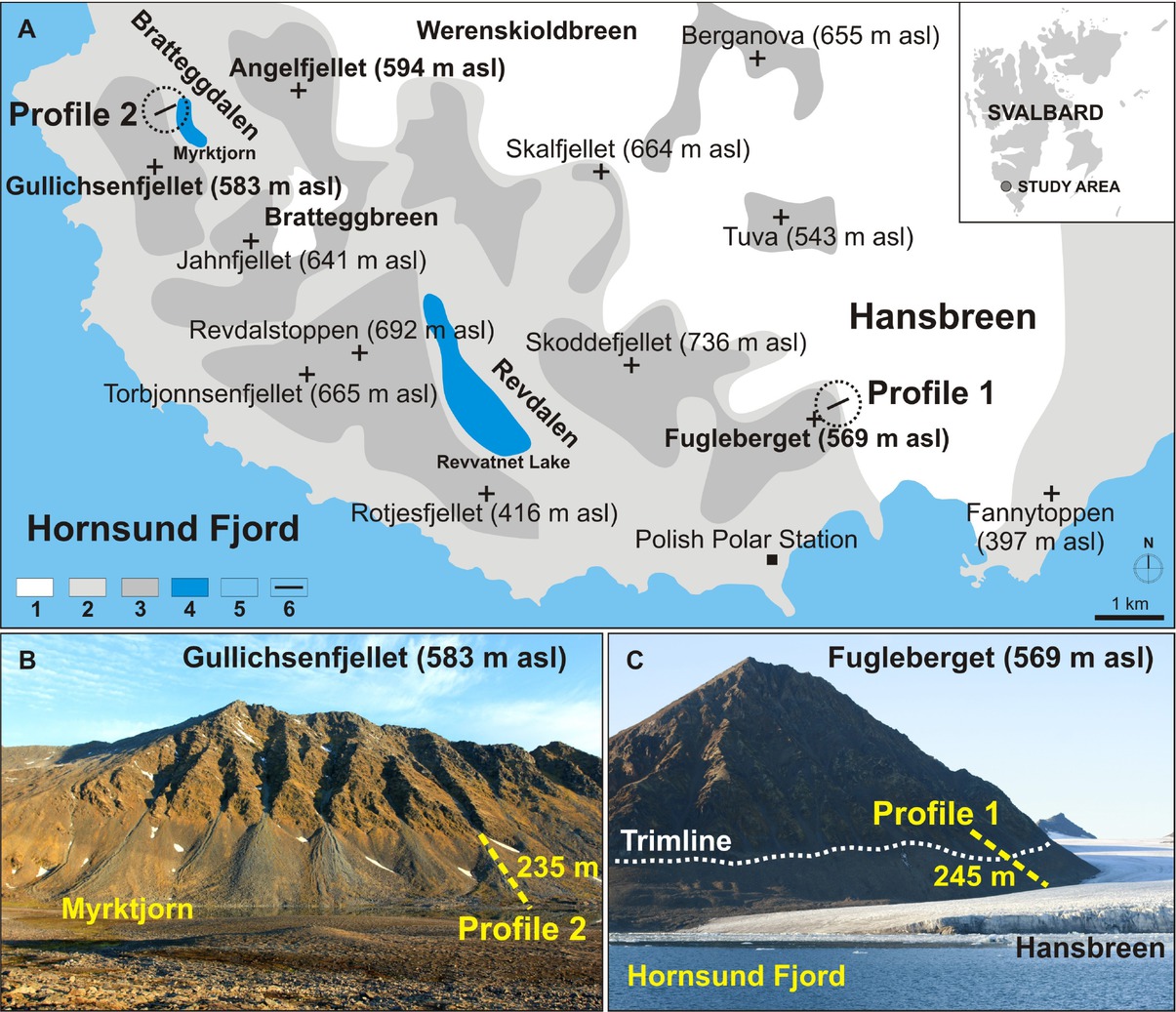
Study area on SW Spitsbergen: A – simplified geomorphological map of the Hornsund Fjord region; B– Gullichsenfjellet’s slopes in the Bratteggdalen with location of profile 2; C– Fugleberget’s slopes near the Hansbreen with location of profile 1. Symbols: 1 – glaciers, 2 – debris-mantled slopes, 3 – rock slopes, 4 – lakes, 5 – Hornsund Fjord, 6 – geophysical profiles.
Both slopes are located near the Polish Polar Station in Hornsund, where the average air temperature for the period 1979-2009 was −4.3∘C. The warmest month was July, while the coldest was January. The average air temperature in these months was +4.4∘C and −10.9∘C [26]. The average precipitation was 434.4 mm, with the highest rainfall during the summer [27]. The location of the study sites on the coast of the Greenland Sea and the area’s level of precipitation lead to a high level of humidity – the average for the studied period was 79% [28]. Changes in air temperature and precipitation in the study area are also linked to sea ice conditions [29]. The study area is affected by permafrost conditions, which is treated as a state of a ground with temperature at or below 0∘C occurring in a period of 2 years [30]. The depth of the active layer is 2-5 m [31, 32, 33].
The sediment supply area of the first slope consists of amphibolites [34]. The rocky slope that forms the Fugleberget massif and produces slope material in the study area covers about 0.33 km2 (Table 1). The slope is located next to the western marginal zone of the Hansbreen, which descends to the water of the fjord, with a length of around 15 km and an area of around 50 km2 [35, 36]. In the period 1936-2010 the length of this glacier decreased by nearly 1.8 km [37, 38]. The trimline extends through the Fugleberget’s slopes. Sites above the trimline produce texturally immature debris and block material from rockfalls. Below this line, slope material is mixed with moraine material. The surface of this slope is levelled and moulded by snow avalanches. The upper part of the slope features debris flow gullies with depths of 0.5-1.0 m.
Characteristics of the studied talus slopes.
| Profile Name | Profile 1 Fugleberget | Profile 2 Gullichsenfjellet | Profile 3 Szeroki Piarg |
|---|---|---|---|
| Location | Near Hansbreen, | Bratteggdalen, | Rybi Potok Valley, Tatra |
| Hornsund Fjord region, | Hornsund Fjord region, | Mountains, Poland | |
| SW Spitsbergen, Norway | SW Spitsbergen, Norway | ||
| Scale of age/time | hundreds | thousands | tens of thousands |
| Length of slope/profile | 245 m | 235 m | 460 m |
| Elevation range | 90-190 m a.s.l. | 85-150 m a.s.l. | 1,395-1,550 m a.s.l. |
| Dominant lithology | amphibolite | quartzite | granitoids |
| Slope angle | 35∘ | 30∘ | 25∘ |
| Aspect | NE | NE | N |
| Sediment supply area | 0.33 km2 | 0.66 km2 | 0.50 km2 |
| Height of sediment supply area | 379 m | 433 m | 888 m |
The Bratteggdalen, where the second study slope is located, features three elevation levels connected by a network of streams and proglacial lakes. The highest lake is located at 234 m a.s.l. in front of the Bratteggbreen, which filled the entire valley a few thousand years ago. The “middle” lake is found at 139 m a.s.l. and the lowest lake, named Myrktjörn (jörn means lake), is at 72 m a.s.l. [39]. The valley has an asymmetrical shape. The smooth slopes of the Angelfjellet massif (597 m a.s.l.) limit the valley to the northeast. In this part there is debris cover, which, on the lower slopes, appears in the form of polygons of patterned ground flooded partly by the waters of Myrktjörn. The other side of the valley is steeper and limited to the southwest by the quartz Gullichsenfjellet massif (583ma.s.l.). At the foot of this massif, a complex of 8 talus cones developed and one of its slopes was chosen for study purposes. The shape of the slope is straight in the proximal part and concave in the distal part. Morphogenetic processes typical of slopes in Spitsbergen such as snow avalanches transporting slope material from rockfalls and debris flows moulding upper slopes are common here [40]. On the studied cone, debris flow gullies are deep (up to 1.5-2.0 m) and characterized by high levées.
The rocky slopes of the Gullichsenfjellet massif are steep and cut by a system of deep chutes and gullies formed on bedrock fractures [41]. Both of them transport not only debris and block material, but also water from the snow patches’ melting occurring throughout the year. Water found at the apex of the cones infiltrates into the internal structures. Some water flows through dissolving slope material, and some is stored in the slope material in the form of pore ice. Local conditions predisposed to the retention of precipitation and snow melt water are affected by topography, irradiation, and relatively high precipitation associated with the short distance to the coast [42].
2.2 Rybi Potok Valley, Tatra Mountains, Poland
Studies in the Tatra Mountains were carried out on the Szeroki Piarg cone, which is the largest and oldest talus landform among all study sites. It is estimated that this structure developed about 10 ka and is related to the end of the last glaciation in this region [24, 43]. The studied slope is found in the upper part of the Rybi Potok Valley and constitutes the lowest part of the Mięguszowieckie Szczyty slope system (Figure 2). This system includes the northern walls of the valley, which culminate in the Mięguszowiecki Szczyt Wielki peak (2,438 m a.s.l.); Mięguszowiecki Kocioł glacial cirque, partially occupied by a firnice patch (glacieret); and the Szeroki Piarg cone that descends to Morskie Oko Lake, the largest lake in the Tatra Mountains located at 1,395ma.s.l. with a surface area 0.35 km2. The system consists of the sediment supply area of the Szeroki Piarg cone, which is formed of granitoids and occupies 0.5 km2 (Table 1). The gully above the studied slope is a few to several tens of meters wide and deep. It also serves as the channel of the stream that collects water from the sediment supply area. This stream flows in a chute on the cone’s surface in the proximal part to about 150 m, then the water infiltrates into the slope material. The surface of the Szeroki Piarg cone is covered by debris flow gullies a few meters deep [44]. The slope material is characterized by poor fall sorting and a large amount of blocky material causing numerous air-filled spaces in its surface layer.
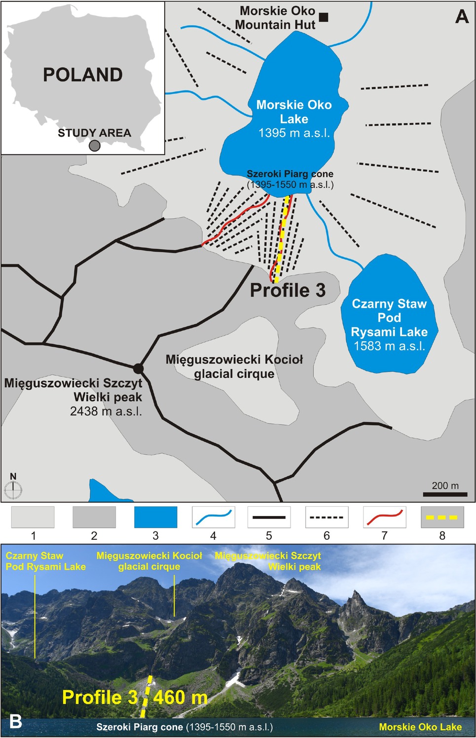
Study area in the Tatra Mountains: A – Simplified geomorphological map of the highest part of the Rybi Potok Valley; B – A view of the Szeroki Piarg cone with marked location of profile 3 from the Morskie Oko Mountain Hut (photo by B. Gądek). Symbols: 1 – debris-mantled slopes, 2 – rock slopes, 3 – lakes, 4 – rivers and streams, 5 – sharp rocky ridges, 6 – talus slopes or cones, 7 – debris flows, 8 – geophysical profile.
The climatic conditions in the Tatra Mountains are milder than in SW Spitsbergen, but are characterized by low average air temperatures, high precipitation, long-lasting snow cover and intense thunderstorms [45]. The coldest month is February and the warmest July; the mean annual air temperature is in the range of 2-3∘C at elevations of 1,400-1,550ma.s.l. [46]. The elevation zones dividing rocky masses in terms of temperature variation, level of precipitation, and permafrost occurrence in the alpine zone are typical for this area [47, 48].
3 Method
3.1 Electrical resistivity tomography (ERT)
The ERT method has become increasingly popular in studying both the polar and alpine environments, especially in the context of permafrost occurrence [49]. However, in the context of talus slopes this method has certain limitations. Primarily, they include obstacles deriving from extremely difficult terrain conditions, such as inaccessible and steep slopes, logistical constraints, and in effect higher costs. Secondly, the material of talus slopes usually consists of blocky debris [14, 50, 51]. Air-filled spaces in the internal structure and lack of sufficient moisture in the surface layer make it difficult to perform measurements and may cause electrical contact failure in the case of many electrodes [52].
Despite those obstacles, numerous studies of slopes confirmed the usefulness of generating ERT measurements in different latitudes that allow to identify the most important elements of internal structure and determine the current stage of development for selected slopes. Based on ERT results, we cannot identify traces of earlier stages, because the stratification of talus slope material is difficult to examine in detail. Thus, the use of a second geophysical method, ground-penetrating radar (GPR), is recommended to confirm ERT measurements and minimize the ambiguity of the individual geophysical solutions.
Studies performed on Spitsbergen and in the Tatra Mountains were based on two sets of measurements: (1) LUND automatic electric imaging system with SAS (Signal Averaging System) 4000 Terrameter manufactured by ABEM (Sweden) (profiles 1 and 3), (2) ARES made by the Czech company GF Instruments (profile 2). All study profiles were examined using a Wenner-Schlumberger array, which is recommended for horizontal structures [53, 54], but can be also successfully used in analysing vertical structures [55]. All profiles were established using 5-m spacing between electrodes. The length of the profiles was depending on the length of the slope and for profiles 1 to 3 was respectively 245 m, 235 m and 460 m what effected on the depth recognition – respectively 30 m for profiles 1 and 2 and 70 m for profile 3.
The resulting measurements were analysed via RES2DINV software (Geotomo Software, Malaysia). The root-mean-squared (RMS) error, which indicate the differences between calculated and measured values of apparent resistivity, for the 5th iteration equalled 4.9% (profile 1), while for the 4th iteration it equalled 4.1% (profile 2) and 5.3% (profile 3). The resulting model was based on 298 points, 476, and 1,129 points, respectively. A distorted finite-element grid with damped distortion was used in topographical modelling (damping factor = 0.75).
3.2 Geomorphological observations and measurements
Cartographic data including topographic maps, orthophotomaps and aerial photos of the study areas were used for basic morphometric measurements and observations [34, 38, 56, 57, 58]. The detailed measurements of the talus slopes were made using ArcGIS tools (Table 1). The results of morphometric measurements and geomorphological observations supported the interpretation of the ERT measurements. Additional data, such as photos of study area and descriptive material, were the supplement for collected material. The positions of the ERT profiles were recorded by a precise GPS receiver. Slope inclination was measured using a manual inclinometer, and then, the measurement was tested in ArcGIS.
3.3 Selection of study sites
The research concept assumes a comparison of talus slopes on the different stage of development. Therefore, the main selection criterion was the age of studied slopes, which for these kind of depositional forms can be determined since the beginning of deglaciation. Furthermore, the talus slopes were the subject of earlier study on broadly understood geomorphology [24, 25, 59]. Additionally, it should be noted that the studied sites are respectively representative for SW Spitsbergen and Tatra Mountains, because these forms occur commonly in both regions.
4 Results and interpretation
4.1 Profile 1 – Fugleberget, Spitsbergen
The results of ERT measurements conducted on the talus slope of Fugleberget indicate the presence of two different zones in its internal structure: an upper zone in the upper 0-100 m of the profile and a lower zone in the lower 100-245 m (Figure 3). On the surface, the boundary between them corresponds to the well-preserved trimline of the Hansbreen.
![Figure 3 Profile 1: ERT longitudinal section of Fugleberget’s eastern slopes; the length is 245 m (modified from Senderak et al. [25]).](/document/doi/10.1515/geo-2019-0084/asset/graphic/j_geo-2019-0084_fig_003.jpg)
Profile 1: ERT longitudinal section of Fugleberget’s eastern slopes; the length is 245 m (modified from Senderak et al. [25]).
The upper zone is characterized by a three-layer structure. The surface layer of the slope to a depth of 2-3 m exhibits the lowest values of electrical resistivity (ER) for the entire profile (excluding the bedrock) in the range of 4-20 kΩm, which may indicate the presence of an active layer that includes loose slope material. Below, at a depth of 3-25 m, there is a layer characterized by significantly higher values of ER in the range of 20-60 kΩm,which is typical for debris affected by permafrost, i.e. pore ice [21]. The deepest layer in this zone found at a depth of 25mindicates the presence of materials with values of ER in the range of 4-20 kΩm, which indicates weathered amphibolite bedrock of the Fugleberget massif.
The lower zone of profile 1 also consists of three layers. The first part of the slope is a continuation of the active layer visible in the upper zone, but is built of mixed moraine and slope material. Material to a depth of 2-3 m has values of ER in the range of 4-20 kΩm. Below, at a depth of 3-10 m, there is a section of the profile in which the ER of the medium is in the range of 20-60 kΩm, indicating the presence of material affected by permafrost. The depth was analysed in detail on the cross-sectional profile made by the ERT method for this site [25]. The deepest level of the lower zone yields the highest values of ER for the entire profile, in the range of 60-750 kΩm. These values indicate the presence of glacial ice in the internal structure of the slope to a depth of at least 10 m [49]. The thickness of the ice was not determined, but it is at least 30 m. The existence of buried glacial ice was also found several meters above trimline. It was located at a depth of a few meters (ca. 10 m). The height of its roof was therefore very similar to the height of the ice surface diagnosed near trimline. This kind of structure is connected with the glacier surface in ablation zone [36]. In profile 1, the glacial ice detected in the contact zone with the trimline is very close to the slope surface and may incorrectly indicate an absence or small thickness of the slope material that forms the active layer or is affected by permafrost. It is due to the relatively low resolution of the surface layer observations caused by the spacing of the electrodes (5 m) and the topography of the terrain affecting the distortion of ERT measurements.
4.2 Profile 2 – Gullichsenfjellet, Spitsbergen
As with profile 1, the subsurface image of profile 2 is characterized by a bipartite nature of its horizontal profile (Figure 4). There is no geomorphological feature on the slope
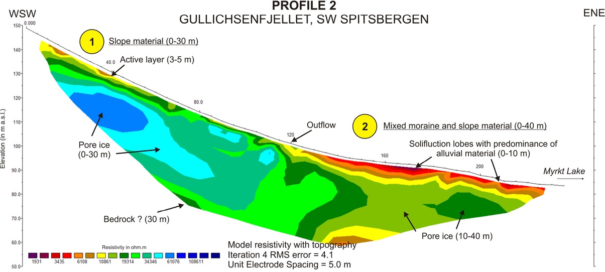
Profile 2: ERT method, longitudinal section of Gullichsenfjellet’s northern slopes; the length is 235 m.
surface that can determine the boundary of two zones (e.g. trimline). At 120 m down the profile, however, there is a periodic outflow of water dividing the slope surface into a straight upper zone (section 0-120 m) and a slightly concave lower zone (section 120-235 m).
The upper zone has a 2-layer structure. The upper 0-80 m of the profile yield a surface layer with a depth of 3-5 m that has values of ERin the range of 7-20 kΩm, which may correspond to an active layer with a large amount of empty space in the slope material [49]. This layer wedges out about 80m down the slope, probably because the large supply of fresh slope material in the apex of the cone gradually thins with transport on the slope surface. The second layer in the upper zone is found at a depth of 0 (at 80-120m of the profile) to 30 m and has the highest values of ER for the entire profile in the range of 20-60 kΩm. The maximum thickness of this zone is beyond the maximum penetration depth of this ERT survey.
The lower zone also consists of two layers, where contemporary development is dominated by alluvial processes. The surface layer has the lowest absolute values of ER for the entire profile, in the range of 2-10 kΩm, occurring at a depth of 0-10 m. This part of the slope is covered by fine-fraction material (less than 2 mm), which is carried by water emerging at 120 m down the profile. Fine material and surface runoff cause an intensification of solifluction processes (e.g. gelifluction and frost creep). The deeper layer is characterized by higher values of ER in the range of 10-20 kΩm, and affects the slope structure at a depth of 10-40 m. Based on these results, mixed moraine and slope material affected by permafrost may be inferred. Unusual values of ER for permafrost on Spitsbergen are discussed in the following section.
4.3 Profile 3 – Szeroki Piarg, Tatra Mountains
The results of ERT measurements on the Szeroki Piarg cone indicate the existence of a one-layer structure and no clear division into zones was revealed in the slope profile. It suggests that existing layer consists of the irregular slope material directly overlying a layer that includes granite bedrock. The internal structure of the slope is characterized by two parts (Figure 5).
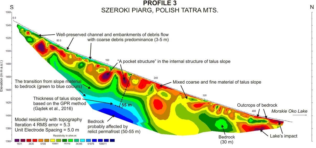
Profile 3: ERT method, longitudinal section of the Szeroki Piarg cone located on the northern slopes of the Mięguszowieckie Szczyty massif; the length is 460 m.
The first part of layer is found at the slope surface with a depth range of 0-25 m and has the lowest values of ER in the range 2-8 kΩm. The slope material in the upper part of the profile, at 0-280 m, characterises “a pocket structure”, which contains many spaces filled with fine material. This part of the slope is formed primarily from large rockfalls whose products were blocks deposited at the end of the studied gully and below it. In this part of the profile (0-280 m), the slope surface to a depth of 3-5 m has higher values of ER in the range of 8-25 kΩm. As show an observations at site, this correlates with a well-consolidated channel and embankments of debris flow. The surface layer found over the remainder of the profile, at 280-460 m, has values of ER in a narrower range of 6-8 kΩm, which may correspond to coarse debris, fewer empty spaces in the internal structure, and greater stability of this part of the cone associated with less activity of moulding processes of its surface. Very low values of ER in the range of 2-4 kΩm noted in the lowest parts of the studied slope at 400-460 m are related to its proximity to Morskie Oko Lake, the waters of which affect the distal part of the Szeroki Piarg cone.
The second part of layer identified in profile 3 is found at a depth of 25-50 m and has values of ER in the range of 8-30 kΩm. The position of this part at the top of the studied slope is parallel to the inclination of the cone surface. High values of ER and their wide range may indicate a gradual transition from slope material to bedrock (green to blue colour on the profile). This part also reaches its maximum thickness on the cone with a depth of 50-55 m in the middle part of the structure (and also the profile). The last part visible in the subsurface image is the zone with the highest values of ER– in the range of 30-60 kΩm– corresponding to the bedrock on which the talus slope is based. The bedrock is found at a depth of 50-55 m.
5 Discussion
Our studies on Spitsbergen and in the Tatra Mountains confirm a number of widely accepted assumptions that the internal structure of talus slopes may reflect the different environmental conditions associated with their development, which have been changing since deglaciation (Table 2). The most relevant factors affecting talus slope evolution are: the rate of deglaciation, type and size of sediment supply area, lithology of the nearest bedrock, and climate [7, 60, 61]. Each factor is characterized by various activity levels and intensities, which depend on the current period in the evolution of the investigated slope. Based on existing literature sources [7, 13, 14] and our new data on internal structure of talus slopes and especially its spatial distribution,we compare the slopes at the different periods of postglacial development, including paraglacial, periglacial, and talus-alluvial periods (Figure 6). Each of the three studied slopes shares common features that allow to trace their evolution from the present time to around 10 ka, which was the beginning of the end of glaciation in the Pleistocene northern hemisphere.
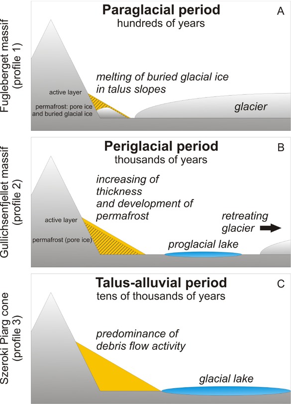
Schematic comparison of three type of studied talus slopes, which were presented from the youngest to the oldest postglacial foms. A – Paraglacial period is dominated by the existence of buried glacial ice in the internal structure of talus slope; B – Periglacial period assumes the activity of frost weathering accelerating the regular supply of debris to talus slopes; C – Talus-alluvial period includes the debris flow activity in the warmer climate conditions with the greater volume of water in the environment of talus slopes.
Summary and comparison of results obtained using the ERT method for all profiles.
| Profile Name | Profile 1 Fugleberget, SW | Profile 2 Gullichsenfjellet, | Profile 3 Szeroki Piarg, |
|---|---|---|---|
| Spitsbergen, Norway | SW Spitsbergen, Norway | Tatra Mts, Poland | |
| Thickness (m) | 25 | 40 | 55 |
| Active layer (m) | 2-3 | 3-5 | No |
| Permafrost (pore ice) (m) | 3-30 | 5-40 | No |
| Buried glacial ice | Yes, 10-30 m | No | No |
| Zone of minimum electrical | Bedrock and thin layer of | Slope surface below | Zone affected by Morskie |
| resistivity | sediments at the slope | outflow at the 120 m point | Oko Lake |
| surface | of the profile | ||
| Zone of maximum electrical | Buried glacial ice in lower | Pore ice in upper zone of | Bedrock of talus slope |
| resistivity | zone of slope | slope | |
| Layer structure | 3 | 2 | 1 |
5.1 The paraglacial period
The slope of the Fugleberget massif (Spitsbergen) represents a paraglacial period (Figure 6A). It is understood as a time when non glacial morphogenetic processes are controlled by the glacial environment [62, 63]. As suggested by Ballantyne [13] for the paraglacial period, the relaxation of bedrock during deglaciation plays a major role in the production and deposition of slope material. Senderak et al. [25] suggest that the successive stages of early evolution of the same slope, where glacial ice affects the redistribution of slope material and formation of the glacial landscape. The development of the studied slope was affected by active tectonics resulting from the retreat of the Hansbreen [13], but this study indicates a close relationship between slope processes and the glacier [25],which has been in retreat since the end of the Little Ice Age at the turn of the 20th century [36, 64, 65]. In this part of the valley, the glacier was situated at an elevation of around 150 m a.s.l. during the transgression, which is marked by a well-preserved trimline in the form of a shelf shape of approximately 5 m in width. The record of the Hansbreen’s former range also consists of glacial ice buried in the internal structure in the lower zone of the slope at a depth of 10 m from the trimline to the profile end (profile section 100-245 m).
During deglaciation and melting of the glacier’s marginal part, talus slope was initially covered by lateral moraine deposits. The glacier then began to be covered by a regular supply of slope material transported from the upper part of the slope by debris flows and snow-rock avalanches, which cause gradient of talus accumulation [66]. Similar processes were identified near the Gås Glacier (nor. Gåsbreen) on the other side of Hornsund Fjord using photogrammetric methods [67]. Above the trimline, the slope material contains no glacier ice. A maximum thickness of 25 m confirmed the results of GPR measurements for the same slope [25]. Along the whole slope, the surface layer of 2-3 m thickness corresponds to the active layer. Below, material is affected by permafrost including buried glacial ice of the Hansbreen.
5.2 Periglacial period
The talus cone at the Gullichsenfjellet massif (Spitsbergen) is a more mature landform, but still affected by the conditions of the polar environment. This particular slope represents a more advanced stage of development, which may be termed a periglacial period (Figure 6B). In Ballantyne’s conceptualization [13], after the stabilizing of tectonic processes, mechanical weathering, especially frost action, prevails in the exposed bedrock, whereas glaciers do not affect slope evolution. This stage is longer than the preceding paraglacial period [63], and in the case of the studied slope, it may last for a few thousands of years. The overall relief of the studied slope surface is concave,which is typical of similar landforms on Spitsbergen [68]. The only convex landform in slope morphology is the chute found in the lower part of the studied slope, formed of rock debris derived from nival processes. The origin of the chute is vague; on the one hand may be related to the occurrence of snow-rock avalanches transporting material from the upper parts of the massif [6], but on the other hand the avalanches are channelled by the existence of the chute, which may be older than the deglaciation [23, 69]. In the upper part of the slope, the surface is moulded by debris flows, leaving gullies with a depth of 1-2 m. The nival chutes and transport gullies confirm that avalanches and flows of slope material dominate in a periglacial environment [70, 71]. Based on a dating of the youngest glacial and periglacial landforms in the Revdalen located at a similar elevation as the Hornsund Fjord area, the talus slopes in the Bratteggdalen could have started to develop earlier than 3.5 ka [72]. These include the location and shape of zone with the highest values of electrical resistivity in the upper part of the slope,which may suggest the presence of postglacial permafrost (pore ice). The studied slope must have developed in a warmer period, as indicated by the lack of buried glacial ice, or the paraglacial period has never occurred on this slope. If the ice had melted, permafrost could not survive at that time [52]. This part of the slope, however, is reminiscent of the structure of rock glaciers found near the Polish Polar Station in Hornsund, which are a mixture of ice and debris [73, 74]. Examples of similar slopes from Spitsbergen and the Alps show that the permafrost table occurs along the whole slope at the same depth [21, 75]. In the case of profile 2, the thickness of the active layer reaches 3-5 m and is thicker in the lower zone of the slope.
Apart from climatic factors, permafrost can increase or degrade depending on the supply debris to the talus slope [76, 77]. The reason for the relatively large thickness of the active layer of the Gullichsenfjellet’s slopes is the regular supply of slope material that overtakes the permafrost accretion process in the slope structure, which confirms the high activity of rock slope destruction processes [78]. In the lower part of profile 2, permafrost has unusually low values of electrical resistivity in the range of 10-20 kΩm, which are about ten times lower than that measured at the other sites on Spitsbergen including the Hornsund Fjord area [21, 32, 79]. This is caused by a large amount of water in the environment coming from higher,orographic precipitation, and also the short distance to Myrktjörn, which may affect the internal structure of distal parts of slopes.
5.3 Talus-alluvial period
The Szeroki Piarg cone in the Tatra Mountains differs from the Spitsbergen examples, especially in the size of the sediment supply area and the length of the profile. The relief of the slope surface is extremely variable, ranging from stable and inactive parts covered with fine material and low alpine vegetation to deep debris flow gullies draining the slope along its whole length. Since the last glaciers retreated from the area around 12.5 ka [80], the Tatra region has developed under conditions typical for high-mountain environments [46, 81, 82], that is exposure to high air temperature fluctuations, frost action, and high activity of surface evolution processes (e.g. avalanches, debris flows, rockfalls). Currently, there is much more water in the environment of the Tatra Mountains than in the past, which has an impact on alluvial and fluvial processes [83]. The water involved in the transport of slope material comes from snow melting in the upper parts of the Mięguszowieckie Szczyty massif during spring and also from heavy rains in the summer and autumn [11]. The transformation of the slope caused by short (lasting minutes) and intense rainfall continued for hundreds of years [84]. In the Polish-language research literature, this process is known as “aluwiacja”, which means debris flow activity, but strictly speaking not alluvial processes [85, 86]. The most suitable genetic type for the Szeroki Piarg cone is the talus-alluvial slope (Figure 6C), which features debris flow landforms as well as fluvial activity, and rockfalls are a predominant process [44]. Another mechanism that transports material is frequent snow avalanches, which tend to smooth the shape of a long slope [87, 88]. The varied slope surface corresponds to a heterogeneous internal structure shown by ERT measurements. In the Tatra Mountains, above 1,900 m of elevation, there may be sporadic permafrost [24]. Geophysical data obtained on the Szeroki Piarg cone, situated below 1,550 m a.s.l., have confirmed the lack of contemporary permafrost in the slope structure. The layer in the form of irregular slope material directly overlying a layer that includes granite bedrock was identified. Examples of similar stratified talus slopes with large boulders coming from high-magnitude rockfalls were studied in the Făgăraș Mountains in Romania using GPR [89]. The thickness of the talus slope exceeds 50 m and is consistent with GPR results produced for the same slope [24]. The deeper increase in the electrical resistivity of the granite bedrock to over 100,000 m indicates a decrease in its temperature. The presence of a relic of permafrost (frozen granite) cannot be excluded. In other places in the Tatra Mountains this possibility was signalled by Dobiński [48]. Deposition of slope material is very intense, although the climatic conditions are more favourable than in the polar environment.However, it should be noted that talus slopes developing in the Tatra Mountains have much larger sediment supply areas than deposition sites on Spitsbergen. This is due to differences in the geological structure of the mountain ranges at both locations, which in each case is a result of the formation of crystalline rocks, which are then subject to displacement associated with the region’s orogeny.
6 Conclusions
The study explores various stages of talus slope development, reflected in the ERT profiles. Based on results, three development periods were identified: paraglacial, periglacial, talus-alluvial.
The paraglacial period is the most dynamic stage of talus slopes’ development. It is mostly characterized by the melting of buried glacial ice in the internal structure of talus slopes. Interactions between the glacier and slopes play a crucial role at the beginning of the evolution process. In our view, the relaxation of bedrock during deglaciation, as suggested by Ballantyne [13], has secondary importance for the process of development. The earliest period lasts from decades to hundreds of years, when glacial ice becomes completely melted and the glacier does not affect talus slopes directly or indirectly.
Then, the periglacial period begins and causes a stabilization of all slope processes and triggers a regular supply of sediment to slope surfaces, which is consistent with views put forth by Ballantyne. Talus slopes may develop in the periglacial environment for several thousands of years, which was observed and studied mostly on Spitsbergen and in the Alps. The internal structure of talus slopes is usually affected by permafrost (below a depth of 2-5 m) until the end of the period dominated by typical periglacial conditions.
The most mature period, not referred to in previous works on evolution, is the talus-alluvial, which is significantly different and characterized by a greater volume of water in the environment resulting from a warmer climate and higher precipitation. Talus-alluvial slopes are dominated by very high debris flow activity. The oldest landforms developed for at least several tens of thousands of years.
Many elements of the internal and external structure of talus slopes have changed since the beginning of deglaciation and the formation of initial slopes in the northern hemisphere. Research on talus slope evolution has shown that the thickness of slope material increases in the range of 25-55 m, wherein slope angle decreases from 35 to 25∘. Based on major changes in structure and detailed interpretation of geophysical and geomorphological data, we have compared three talus slopes involving key elements of glacial landscape (glacier, talus slopes, glacial lake). The proposed typology of development periods need to be expanded using an interdisciplinary approach in further studies and subsequently compared with new case studies of talus slopes.
Acknowledgement
The paper was prepared as part of the doctoral thesis of Krzysztof Senderak at the Centre for Polar Studies, University of Silesia in Katowice, Poland. The research was financed by the National Science Centre in Poland received by KS as part of the Preludium 12 project: Determination of the evolution of slopes of southern Spitsbergen on the background of climate changes (2016/23/N/ST10/00162). The participation of KS in a polar expedition in 2012 was financed by the Faculty of Earth Sciences and Environmental Management at the University of Wroclaw. The final stage was supported by the Centre for Polar Studies – Leading National Research Centre (KNOW). The authors wish to thank Marek Kasprzak, Ph.D. (University of Wrocław)for his substantial assistance with ERT measurements in the Bratteggdalen during the expedition in 2012 as well as Tatra National Park for permission to perform research in the park. We are grateful to Marta Bystrowska and Paweł Pilch for their assistance with the translation of the paper and to Mirosław Szumny, Dariusz Ignatiuk, Michał Laska, and Arkadiusz Piwowarczyk (University of Silesia) for their assistance in the field.
References
[1] Albjär G., Rehn J., Stromquist L., Notes on talus formation in different climates. Geografiska Annaler 61A (3-4), 1979, 179-185.10.1080/04353676.1979.11879989Search in Google Scholar
[2] Luckman B.H., Talus Slopes. In S.A. Elias (Ed.), The Encyclopedia of Quaternary Science, vol. 3, 2013, 566-573.10.1016/B0-444-52747-8/00373-2Search in Google Scholar
[3] De Geer G., Rapport om den svenska geologiska expeditionen till Isfjorden. Pä Spetsbergen sommaren 1896. Ymer 16, 1896, 259-266.Search in Google Scholar
[4] Rapp A., Talus slopes and mountain walls at Tempelfjorden, Spitsbergen – a geomorphological study of the denudation of slopes in an Arctic locality. Norsk Polarinstitutt Skrifter 119, 1960.Search in Google Scholar
[5] Karczewski A., Andrzejewski L., Chmal H., Jania J., Kłysz P., Kostrzewski A., Lindner L., Marks L., Pękala K., Pulina M., Rudowski S., Stankowski W., Szczypek T., Wiśniewski E., Hornsund, Spitsbergen. Geomorfologia – Geomorphology. 1:75 000. University of Silesia, Katowice, 1984.Search in Google Scholar
[6] Luckman B.H., The Geomorphic Activity of Snow Avalanches. Geografiska Annaler 59A (1/2), 1977, 31-48.10.1080/04353676.1977.11879945Search in Google Scholar
[7] Åkerman H.J., Notes on talus morphology and processes in Spitsbergen. Geografiska Annaler 66A (4), 1984, 267-284.10.1080/04353676.1984.11880115Search in Google Scholar
[8] André M.-F., Dating slope deposits and estimating rates of rock wall retreat in northwest Spitsbergen by lichenometry. Geografiska Annaler 68A (1-2), 1986, 65-75.10.1080/04353676.1986.11880159Search in Google Scholar
[9] André M.-F., Frequency of debris flows and slush avalanches in Spitsbergen: a tentative evaluation from lichenometry. Polish Polar Research 3-4, 1990, 345-363.Search in Google Scholar
[10] André M.-F., Geomorphic impact of spring avalanches in Northwest Spitsbergen (79∘ N). Permafrost and Periglacial Processes 1, 1990, 97-110.10.1002/ppp.3430010203Search in Google Scholar
[11] Kotarba A., Strömquist, L., Transport, sorting and deposition processes of alpine debris slope deposits in the Polish Tatra Mountains. Geografiska Annaler 66A (4), 1984, 285-294.10.1080/04353676.1984.11880116Search in Google Scholar
[12] Rączkowska Z., Slope dynamics in the periglacial zone of the Tatra Mts. Biuletyn Peryglacjalny 38, 1999, 127-133.Search in Google Scholar
[13] Ballantyne C.K., Paraglacial geomorphology. Quaternary Science Reviews 21, 2002, 1935-2017.10.1016/B0-444-52747-8/00102-2Search in Google Scholar
[14] Blikra L.H., Nemec W., Postglacial colluvium in western Norway: depositional processes, facies and palaeoclimatic record. Sedimentology 45, 1998, 909-959.10.1046/j.1365-3091.1998.00200.xSearch in Google Scholar
[15] Van Steijn H., Boelhouwers J., Harris S.A., Hétu, B., Recent research on the nature, origin and climatic relations of blocky and stratified slope deposits. Progress in Physical Geography 26, 2002, 551-575.10.1191/0309133302pp352raSearch in Google Scholar
[16] Iturrizaga L., Talus cones as key landforms for reconstructing the extent of former glaciations. Quaternary International 279-280, 2012, 217.10.1016/j.quaint.2012.08.437Search in Google Scholar
[17] Haeberli W., Mountain permafrost – research frontiers and a special long-term challenge. Cold Regions Science and Technology 96, 2013, 71-76.10.1016/j.coldregions.2013.02.004Search in Google Scholar
[18] Otto J.C., Sass, O., Comparing geophysical methods for talus slope investigations in the Turtmann valley (Swiss Alps). Geomorphology 76, 2006, 257-272.10.1016/j.geomorph.2005.11.008Search in Google Scholar
[19] Schrott L., Sass O., Application of field geophysics in geomorphology: Advances and limitations exemplified by case studies. Geomorphology 93, 2008, 55-73.10.1016/j.geomorph.2006.12.024Search in Google Scholar
[20] Sass O., Bedrock detection and talus thickness assessment in the European Alps using geophysical methods. Journal of Applied Geophysics 62, 2007, 254-269.10.1016/j.jappgeo.2006.12.003Search in Google Scholar
[21] Siewert M.B., Krautblatter M., Christiansen H.V., Eckerstorfer M., Arctic rockwall retreat rates estimated using laboratory-calibrated ERT measurements of talus cones in Longyeardalen, Svalbard. Earth Surface Processes and Landforms 37 (14), 2012, 1542-1555.10.1002/esp.3297Search in Google Scholar
[22] André M.F., Holocene Rockwall retreat in Svalbard: a triple-rate evolution. Earth Surf. Process. Land. 22, 1997, 423-440.10.1002/(SICI)1096-9837(199705)22:5<423::AID-ESP706>3.0.CO;2-6Search in Google Scholar
[23] Berthling I., Etzelmüller B., Holocene Rockwall Retreat and the Estimation of Rock Glacier Age, Prins Karls Forland, Svalbard. Geografiska Annaler. 89A (1), 2007, 83-93.10.1111/j.1468-0459.2007.00309.xSearch in Google Scholar
[24] Gądek B., Grabiec M., Kędzia S., Rączkowska Z., Reflection of climate changes in the structure and morphodynamics of talus slopes (the Tatra Mountains, Poland). Geomorphology 263, 2016, 39-49.10.1016/j.geomorph.2016.03.024Search in Google Scholar
[25] Senderak K., Kondracka M., Gądek B., Talus slope evolution under the influence of glaciers with the example of slopes near the Hans Glacier, SW Spitsbergen, Norway. Geomorphology 285, 2017, 225-234.10.1016/j.geomorph.2017.02.023Search in Google Scholar
[26] Marsz A., Air temperature. In A. Marsz, A. Styszyńska (Eds.), Climate and climate change at Hornsund, Svalbard. Gdynia Maritime University, Gdynia, 2013, 145-187.Search in Google Scholar
[27] Łupikasza E., Atmospheric precipitation. In A. Marsz, A. Styszyńska (Eds.), Climate and climate change at Hornsund, Svalbard. Gdynia Maritime University, Gdynia, 2013, 199-211.Search in Google Scholar
[28] Marsz A., Humidity. In A. Marsz, A. Styszyńska (Eds.), Climate and climate change at Hornsund, Svalbard. Gdynia Maritime University, Gdynia, 2013, 189-198.Search in Google Scholar
[29] Osuch M., Wawrzyniak T., Inter-and intra-annual changes in air temperature and precipitation in western Spitsbergen. International Journal of Climatology 37 (7), 2016, 3082-3097.10.1002/joc.4901Search in Google Scholar
[30] Harris S.A., French H.M., Heginbottom J.A., Johnston G.H., Ladanyi B., Sego D.C., Van Everdingen R.O., Glossary of Permafrost and Related Ground-Ice Terms. National Reserach Council of Canada, Ottawa, Technical Memorandum No. 142, 1988.Search in Google Scholar
[31] Dolnicki P., Grabiec M., Puczko D., Gawor Ł., Budzik T., Klementowski J., Variability of temperature and thickness of permafrost active layer at coastal sites of Svalbard. Polish Polar Research 34 (4), 2013, 353-374.10.2478/popore-2013-0026Search in Google Scholar
[32] Kasprzak M., Strzelecki M.C., Traczyk A., Kondracka M., Lim M., Migała K., On the potential for a bottom active layer below coastal permafrost: the impact of seawater on permafrost degradation imaged by electrical resistivity tomography (Hornsund, SW Spitsbergen). Geomorphology 293, 2017, 347-359.10.1016/j.geomorph.2016.06.013Search in Google Scholar
[33] Wawrzyniak T., Osuch M., Napiórkowski J., Wastermann S., Modelling of the thermal regime of permafrost during 1990–2014 in Hornsund, Svalbard. Polish Polar Research 37 (2), 2016, 219-242.10.1515/popore-2016-0013Search in Google Scholar
[34] Czerny J., Kieres A., Manecki M., Rajchel J., Geological map of the SW part of Wedel Jarlsberg Land, Spitsbergen, 1:25 000. Institute of Geology and Minerals Deposits, University of Mining and Metallurgy, Krakow, 1993.Search in Google Scholar
[35] Błaszczyk M., Jania J., Kolondra L., Fluctuations of tidewater glaciers in Hornsund Fjord (Southern Svalbard) since the beginning of the 20th century. Polish Polar Research 34 (4), 2013, 327-352.10.2478/popore-2013-0024Search in Google Scholar
[36] Grabiec M., Jania J., Puczko D., Kolondra L., Budzik T., Surface and bed morphology of Hansbreen, a tidewater glacier in Spitsbergen. Polish Polar Research 33 (2), 2012, 111-138.10.2478/v10183-012-0010-7Search in Google Scholar
[37] Hagen J.O., Liestøl O., Roland E., Jørgensen T., Glacier Atlas of Svalbard and Jan Mayen. Norsk Polarinstitutt Meddelelser 129, 1993, 141.Search in Google Scholar
[38] Kolondra L., Hornsund Fiord. Changes to the Front Positions of Tidewater Glaciers, Spitsbergen, Svalbard, Norway, Satellite Orthophotomap 1:50 000. Centre for Polar Studies, University of Silesia in Katowice, Sosnowiec, 2nd updated edition, 2018.Search in Google Scholar
[39] Górniak D., Marszałek H., Dunalska J., Bacterial community succession in an Arctic lake–stream system (Brattegg Valley, SW Spitsbergen). Boreal Environment Research 21, 2016, 115-133.Search in Google Scholar
[40] De Haas T., Kleinhans M.G., Carbonneau P.E., Rubensdotter L., Hauber E., Surface morphology of fans in the high-Arctic periglacial environment of Svalbard: Controls and processes. Earth-Science Reviews 146, 2015, 163-182.10.1016/j.earscirev.2015.04.004Search in Google Scholar
[41] Cieśliński S., Czwartorzędowe ruchy pionowe wybrzeży Hornsundu i geneza przystokowych wałów kamienistych. Przegląd Geologiczny 32, 1984, 525-532 (in Polish).Search in Google Scholar
[42] Senderak K., Wąsowski M., Chemical weathering of talus slopes: the example of slopes in the Brattegg Valley, SW Spitsbergen. Studia Geomorphologica Carpatho-Balcanica, vol. L, 2016, 105-122.Search in Google Scholar
[43] Kotarba A., On the age of debris slops in the Tatra Mountains. Studia Geomorphologica Carpatho-Balcanica 23, 1989, 139-152.Search in Google Scholar
[44] Lempa M., Kaczka R., Rączkowska Z., Morphological and morphometrical analyses reveal the avalanche influence over the talus cones in the Rybi Potok Valley, Tatra Mountains. Studia Geomorphologica Carpatho-Balcanica XLIX, 2015, 15-33.10.1515/sgcb-2015-0007Search in Google Scholar
[45] Hess M., Climate. In Z. Mirek (Ed.), Nature of the Tatra National Park. Tatrzański Park Narodowy, Kraków-Zakopane, 1996, 53-68 (in Polish).Search in Google Scholar
[46] Niedźwiedź T., Climate of the Tatra Mountains. Mountain Research and Development 12 (2), 1992, 131-146.10.2307/3673787Search in Google Scholar
[47] Dobiński W., Permafrost occurence in the Alpinie Zone of the Tatra Mountains, Poland. In A.G. Lewkowicz, M. Allard (Eds.), Proceedings of the Seventh International Conference on Permafrost, June 23–27, 1998, Yellofknife, Canada, 57, 231–237.Search in Google Scholar
[48] Dobiński W., Permafrost. Earth-Science Reviews 108, 2011, 158-169.10.1016/j.earscirev.2011.06.007Search in Google Scholar
[49] Kneisel C., Hauck C., Electrical methods. In C. Hauck, C. Kneisel (Eds.), Applied geophysics in periglacial environments. Cambridge University Press, Cambridge, 2008, 3-27.10.1017/CBO9780511535628.002Search in Google Scholar
[50] Harvey A.M., The coupling status of alluvial fans and debris cones: a review and synthesis. Earth Surf. Process. Landforms 37, 2012, 64-76.10.1002/esp.2213Search in Google Scholar
[51] Sass O., Determination of the internal structure of alpine talus deposits using different geophysical methods (Lechtaler Alps, Austria). Geomorphology 80, 2006, 45-58.10.1016/j.geomorph.2005.09.006Search in Google Scholar
[52] Hilbich C., Marescot L., Hauck C., Loke M.H., Mausbacher R., Applicability of electrical resistivity tomography monitoring to coarse blocky and ice-rich permafrost landforms. Permafrost and Periglacial Processes 20 (3), 2009, 269-284.10.1002/ppp.652Search in Google Scholar
[53] ABEM, Instructions Manual of Terrameter SAS 4000 / SAS 1000. ABEM Instrument AB, Sweden, 2009.Search in Google Scholar
[54] Loke M.H., Tutorial: 2-D and 3-D Electrical Imaging Surveys. Geotomo Software, Malaysia, 2004.10.1071/ASEG2004ab091Search in Google Scholar
[55] Samouëlian A., Cousin I., Tabbagh A., Bruand A., Richard G., Electrical resistivity surveys in soil science: a review. Soil & Tillage Research 83, 2005, 173-193.10.1016/j.still.2004.10.004Search in Google Scholar
[56] Jahn A., Some remarks on evolution of slopes on Spitsbergen. Zeitschrift für Geomorphologie 1, 1960, 49-58.Search in Google Scholar
[57] Kolondra L., Hansbreen, Spitsbergen, Svalbard, Norway, Aerial Orthophotomap 1:25 000. Centre for Polar Studies, University of Silesia in Katowice, Sosnowiec, 2018.Search in Google Scholar
[58] Kolondra L., Werenskioldbreen and surrounding areas, Spitsbergen, Svalbard, Norway, Orthophotomap 1:25 000. Faculty of Earth Science, University of Silesia, Sosnowiec and Norsk Polarinstitutt, Tromso, Sosnowiec, 2002.Search in Google Scholar
[59] Owczarek P., Latocha A., Wistuba M., Malik I., Reconstruction of modern debris flow activity in the arctic environment with the use of dwarf shrubs (south-western Spitsbergen) – a new dendrochronological approach. Zeitschrift für Geomorphologie 57 (3), 2013, 75-95.10.1127/0372-8854/2013/S-00145Search in Google Scholar
[60] Hetu B., Gray J.T., Effects of environmental change on scree slope development throughout the postglacial period in the Chic-Choc Mountains in the northern Gaspé Peninsula, Québec. Geomorphology 32, 2000, 335–355.10.1016/S0169-555X(99)00103-8Search in Google Scholar
[61] Rapp A., Studies of debris cones in Lappland and Spitsbergen. In D.J.A. Evans (Ed.), Cold Climate Landforms. Whiley, Chichester, 1994, 415-435.Search in Google Scholar
[62] Church M., Ryder J.M., Paraglacial sedimentation: consideration of fluvial processes conditioned by glaciation. Geological Society of America Bulletin 83, 1972, 3059-3072.10.1130/0016-7606(1972)83[3059:PSACOF]2.0.CO;2Search in Google Scholar
[63] Slaymaker O., Proglacial, periglacial or paraglacial? In J. Knight, S. Harrison (Eds.), Periglacial and paraglacial processes and environments. Geological Society, London, Special publications 320, 2009, 71-84.10.1144/SP320.6Search in Google Scholar
[64] Błaszczyk M., Jania J., Hagen J.O., Tidewater glaciers of Svalbard: Recent changes and estimates of calving fluxes. Polish Polar Research 30 (2), 2009, 85-142.Search in Google Scholar
[65] Rachlewicz G., Szczuciński W., Ewertowski M., Post - “Little Ice Age” retreat rates of glaciers around Billefjorden in central Spitsbergen, Svalbard. Polish Polar Research 28 (3), 2007, 159-186.Search in Google Scholar
[66] Berthling I., Etzelmüller B., Eiken T., Sollid J.L., Rock glaciers on Prins Karls Forland, Svalbard. I: internal structure, flow velocity and morphology. Permafrost and Periglacial Processes 9 (2), 1998, 135-145.10.1002/(SICI)1099-1530(199804/06)9:2<135::AID-PPP284>3.0.CO;2-RSearch in Google Scholar
[67] Jania J., Debris forms and processes in Gåsdalen region in photogrammetric investigations and repeated terrestrial photograms. In Results of Investigations of the Polish Scientific Spitsbergen Expeditions, Acta Universitatis Wratislaviensis 525 (4), 1982, 96-114.Search in Google Scholar
[68] Nitychoruk J., Dzierżek J., Morphogenetic features of talus cones in northwestern Wedel Jarlsberg Land, Spitsbergen. Polish Polar Research 9 (1), 1988, 73-85.Search in Google Scholar
[69] Nesje A., Whillans I.M., Erosion of Sognefjord, Norway. Geomorphology 9 (1), 1994, 33-45.10.1016/0169-555X(94)90029-9Search in Google Scholar
[70] Decaulne A., Sæmundsson Þ., Páll Jónsson H., Sandberg O., Changes in Deposition on a Colluvial Fan during the Upper Holocene in the Tindastóll Mountain, Skagafjörður District, North Iceland: Preliminary Results. Geografiska Annaler 89A (1), 2007, 51-63.10.1111/j.1468-0459.2007.00307.xSearch in Google Scholar
[71] Mercier D., Étienne S., Sellier D., André M.-F., Paraglacial gullying of sediment-mantled slopes: a case study of Colletthøgda, Kongsfjorden area, West Spitsbergen (Svalbard). Earth Surface Processes and Landforms 34, 2009, 1772-1789.10.1002/esp.1862Search in Google Scholar
[72] Traczyk A., Problemy rozwoju geomorfologicznego Spitsbergenu w świetle analizy rzeźby doliny Rev i jej otoczenia w rejonie Hornsundu. PhD thesis, University of Wroclaw, 1996 (in Polish).Search in Google Scholar
[73] Hartvich F., Blahut J., Stemberk J., Rock avalanche and rock glacier: A compound landform study from Hornsund, Svalbard. Geomorphology 276, 2017, 244-256.10.1016/j.geomorph.2016.10.008Search in Google Scholar
[74] Karczewski A., Kostrzewski A., Marks L., Morphogenesis of subslope ridges to the north of Hornsund, Spitsbergen. Polish Polar Research 2 (1-2), 1981, 29-38.Search in Google Scholar
[75] Van Dam R.L., Landform characterization using geophysics – Recent advances, applications, and emerging tools. Geomorphology 137, 2012, 57-73.10.1016/j.geomorph.2010.09.005Search in Google Scholar
[76] Etzelmüller B., Frauenfelder R., Factors Controlling the Distribution of Mountain Permafrost in the Northern Hemisphere and Their Influence on Sediment Transfer. Arctic, Antarctic, and Alpine Research 41 (1), 2009, 48-58.10.1657/1523-0430-41.1.48Search in Google Scholar
[77] Scapozza C., Lambiel C., Baron L., Marescot L., Reynard E., Internal structure and permafrost distribution in two alpine periglacial talus slopes, Valais, Swiss Alps. Geomorphology 132, 2011, 208-221.10.1016/j.geomorph.2011.05.010Search in Google Scholar
[78] Kneisel Ch., Sæmundsson Þ., Beylich A.A., Reconnaissance Surveys of Contemporary Permafrost Environments in Central Iceland Using Geoelectrical Methods: Implications for Permafrost Degradation and Sediment Fluxes. Geografiska Annaler 89A (1), 2007, 41-50.10.1111/j.1468-0459.2007.00306.xSearch in Google Scholar
[79] Strzelecki M.C., Kasprzak M., Limb M., Świrad Z.M., Jaskólski M., Pawłowski Ł., Modzel P., Cryo-conditioned rocky coast systems: A case study from Wilczekodden, Svalbard. Science of The Total Environment 607-608, 2017, 443-453.10.1016/j.scitotenv.2017.07.009Search in Google Scholar
[80] Makos M., Deglaciation of the High Tatra Mountains. Cuadernos de Investigación Geográfica 41 (2), 2015, 317-335.10.18172/cig.2697Search in Google Scholar
[81] Klimaszewski M., Relief of the Polish Tatra Mountains. Państwowe Wydawnictwo Naukowe, Warszawa, 1988 (in Polish).Search in Google Scholar
[82] Kotarba A., Pech, P., The recent evolution of talus slopes in the High Tatra Mountains (with the Pańszczyca valley as example). StudiaGeomorphologica Carpatho-Balcanica 36, 2002, 69-76.Search in Google Scholar
[83] Rączkowska Z., Recent geomorphic hazards In the Tatra Mountains. Studia Geomorphologica Carpatho-Balcanica 40, 2006, 45-60.Search in Google Scholar
[84] Kotarba A., Natural Environment and Landform Dynamics of the Tatra Mountains. Mountain Research and Development 12 (2), 1992, 105-129.10.2307/3673786Search in Google Scholar
[85] Kotarba A., Formation of high-mountain talus slopes related to debris-flow activity in the High Tatra Mountains. Permafrost and Periglacial Processes 8, 1997, 191-204.10.1002/(SICI)1099-1530(199732)8:2<191::AID-PPP250>3.0.CO;2-HSearch in Google Scholar
[86] Kotarba A., Kaszowski L., Krzemień K., High-mountain denudational system in the Polish Tatra Mountains. Geogr. Studies IGiPZ PAN. Spec. Issue 3, 1987, 1-106.Search in Google Scholar
[87] Jomelli V., Francou B., Comparing the characteristics of rockfall talus and snow avalanche landforms in an Alpine environment using a new methodological approach:Massif des Ecrins, French Alps. Geomorphology 35, 2000, 181-192.10.1016/S0169-555X(00)00035-0Search in Google Scholar
[88] Rączkowska Z., Łajczak A., Margielewski W., Święchowicz J., Recent landform evolution in the Polish Carpathians. In D. Loczy, M. Stankoviansky, A. Kotarba (Eds.), Recent landform evolution, the Carpatho-Balkan-Dinaric Region. Springer, Dordrecht, 2012, 47-101.10.1007/978-94-007-2448-8_5Search in Google Scholar
[89] Onaca A.L., Ardelean A.C., Urdea P., Ardelean F., Sărășan A., Genetic typologies of talus deposits derived from GPR measurements in the alpine environment of the Făgăraș Mountains. Carpathian Journal of Earth and Environmental Sciences 11 (2), 2016, 609-616.Search in Google Scholar
© 2019 K. Senderak et al., published by De Gruyter
This work is licensed under the Creative Commons Attribution 4.0 Public License.
Articles in the same Issue
- Regular Articles
- 2D Seismic Interpretation of the Meyal Area, Northern Potwar Deform Zone, Potwar Basin, Pakistan
- A new method of lithologic identification and distribution characteristics of fine - grained sediments: A case study in southwest of Ordos Basin, China
- Modified Gompertz sigmoidal model removing fine-ending of grain-size distribution
- Diagenesis and its influence on reservoir quality and oil-water relative permeability: A case study in the Yanchang Formation Chang 8 tight sandstone oil reservoir, Ordos Basin, China
- Evaluation of AHRS algorithms for Foot-Mounted Inertial-based Indoor Navigation Systems
- Identification and evaluation of land use vulnerability in a coal mining area under the coupled human-environment
- Hydrocarbon Generation Potential of Chia Gara Formation in Three Selected Wells, Northern Iraq
- Source Analysis of Silicon and Uranium in uranium-rich shale in the Xiuwu Basin, Southern China
- Lithologic heterogeneity of lacustrine shale and its geological significance for shale hydrocarbon-a case study of Zhangjiatan Shale
- Characterization of soil permeability in the former Lake Texcoco, Mexico
- Detrital zircon trace elements from the Mesozoic Jiyuan Basin, central China and its implication on tectonic transition of the Qinling Orogenic Belt
- Turkey OpenStreetMap Dataset - Spatial Analysis of Development and Growth Proxies
- Morphological Changes of the Lower Ping and Chao Phraya Rivers, North and Central Thailand: Flood and Coastal Equilibrium Analyses
- Landscape Transformations in Rapidly Developing Peri-urban Areas of Accra, Ghana: Results of 30 years
- Division of shale sequences and prediction of the favorable shale gas intervals: an example of the Lower Cambrian of Yangtze Region in Xiuwu Basin
- Fractal characteristics of nanopores in lacustrine shales of the Triassic Yanchang Formation, Ordos Basin, NW China
- Selected components of geological structures and numerical modelling of slope stability
- Spatial data quality and uncertainty publication patterns and trends by bibliometric analysis
- Application of microstructure classification for the assessment of the variability of geological-engineering and pore space properties in clay soils
- Shear failure modes and AE characteristics of sandstone and marble fractures
- Ice Age theory: a correspondence between Milutin Milanković and Vojislav Mišković
- Are Serbian tourists worried? The effect of psychological factors on tourists’ behavior based on the perceived risk
- Real-Time Map Matching: A New Algorithm Integrating Spatio-Temporal Proximity and Improved Weighted Circle
- Characteristics and hysteresis of saturated-unsaturated seepage of soil landslides in the Three Gorges Reservoir Area, China
- Petrographical and geophysical investigation of the Ecca Group between Fort Beaufort and Grahamstown, in the Eastern Cape Province, South Africa
- Ecological risk assessment of geohazards in Natural World Heritage Sites: an empirical analysis of Bogda, Tianshan
- Integrated Subsurface Temperature Modeling beneath Mt. Lawu and Mt. Muriah in The Northeast Java Basin, Indonesia
- Go social for your own safety! Review of social networks use on natural disasters – case studies from worldwide
- Forestry Aridity Index in Vojvodina, North Serbia
- Natural Disasters vs Hotel Industry Resilience: An Exploratory Study among Hotel Managers from Europe
- Using Monarch Butterfly Optimization to Solve the Emergency Vehicle Routing Problem with Relief Materials in Sudden Disasters
- Potential influence of meteorological variables on forest fire risk in Serbia during the period 2000-2017
- Controlling factors on the geochemistry of Al-Shuaiba and Al-Mejarma coastal lagoons, Red Sea, Saudi Arabia
- The Influence of Kaolinite - Illite toward mechanical properties of Claystone
- Two critical books in the history of loess investigation: ‘Charakteristik der Felsarten’ by Karl Caesar von Leonhard and ‘Principles of Geology’ by Charles Lyell
- The Mechanism and Control Technology of Strong Strata Behavior in Extra-Thick Coal Seam Mining Influenced by Overlying Coal Pillar
- Shared Aerial Drone Videos — Prospects and Problems for Volunteered Geographic Information Research
- Stable isotopes of C and H in methane fermentation of agriculture substrates at different temperature conditions
- Prediction of Compression and Swelling Index Parameters of Quaternary Sediments from Index Tests at Mersin District
- Detection of old scattered windthrow using low cost resources. The case of Storm Xynthia in the Vosges Mountains, 28 February 2010
- Remediation of Copper and Zinc from wastewater by modified clay in Asir region southwest of Saudi Arabia
- Sedimentary facies of Paleogene lacustrine dolomicrite and implications for petroleum reservoirs in the southern Qianjiang Depression, China
- Correlation between ore particle flow pattern and velocity field through multiple drawpoints under the influence of a flexible barrier
- Atmospheric refractivity estimation from AIS signal power using the quantum-behaved particle swarm optimization algorithm
- A geophysical and hydro physico-chemical study of the contaminant impact of a solid waste landfill (swl) in King Williams’ Town, Eastern Cape, South Africa
- Landscape characterization using photographs from crowdsourced platforms: content analysis of social media photographs
- A Study on Transient Electromagnetic Interpretation Method Based on the Seismic Wave Impedance Inversion Model
- Stratigraphy of Architectural Elements of a Buried Monogenetic Volcanic System
- Variable secondary porosity modeling of carbonate rocks based on μ-CT images
- Traditional versus modern settlement on torrential alluvial fans considering the danger of debris flows: a case study of the Upper Sava Valley (NW Slovenia)
- The Influence of Gangue Particle size and Gangue Feeding Rate on Safety and Service Life of the Suspended Buffer’s Spring
- Research on the Transition Section Length of the Mixed Workface Using Gangue Backfilling Method and Caving Method
- Rainfall erosivity and extreme precipitation in the Pannonian basin
- Structure of the Sediment and Crust in the Northeast North China Craton from Improved Sequential H-k Stacking Method
- Planning Activities Improvements Responding Local Interests Change through Participatory Approach
- GIS-based landslide susceptibility mapping using bivariate statistical methods in North-western Tunisia
- Uncertainty based multi-step seismic analysis for near-surface imaging
- Deformation monitoring and prediction for residential areas in the Panji mining area based on an InSAR time series analysis and the GM-SVR model
- Statistical and expert-based landslide susceptibility modeling on a national scale applied to North Macedonia
- Natural hazards and their impact on rural settlements in NE Romania – A cartographical approach
- Rock fracture initiation and propagation by mechanical and hydraulic impact
- Influence of Rapid Transit on Accessibility Pattern and Economic Linkage at Urban Agglomeration Scale in China
- Near Infrared Spectroscopic Study of Trioctahedral Chlorites and Its Remote Sensing Application
- Problems with collapsible soils: Particle types and inter-particle bonding
- Unification of data from various seismic catalogues to study seismic activity in the Carpathians Mountain arc
- Quality assessment of DEM derived from topographic maps for geomorphometric purposes
- Remote Sensing Monitoring of Soil Moisture in the Daliuta Coal Mine Based on SPOT 5/6 and Worldview-2
- Utilizing Maximum Entropy Spectral Analysis (MESA) to identify Milankovitch cycles in Lower Member of Miocene Zhujiang Formation in north slope of Baiyun Sag, Pearl River Mouth Basin, South China Sea
- Stability Analysis of a Slurry Trench in Cohesive-Frictional Soils
- Integrating Landsat 7 and 8 data to improve basalt formation classification: A case study at Buon Ma Thuot region, Central Highland, Vietnam
- Assessment of the hydrocarbon potentiality of the Late Jurassic formations of NW Iraq: A case study based on TOC and Rock-Eval pyrolysis in selected oil-wells
- Rare earth element geochemistry of sediments from the southern Okinawa Trough since 3 ka: Implications for river-sea processes and sediment source
- Effect of gas adsorption-induced pore radius and effective stress on shale gas permeability in slip flow: New Insights
- Development of the Narva-Jõesuu beach, mineral composition of beach deposits and destruction of the pier, southeastern coast of the Gulf of Finland
- Selecting fracturing interval for the exploitation of tight oil reservoirs from logs: a case study
- A comprehensive scheme for lithological mapping using Sentinel-2A and ASTER GDEM in weathered and vegetated coastal zone, Southern China
- Sedimentary model of K-Successions Sandstones in H21 Area of Huizhou Depression, Pearl River Mouth Basin, South China Sea
- A non-uniform dip slip formula to calculate the coseismic deformation: Case study of Tohoku Mw9.0 Earthquake
- Decision trees in environmental justice research — a case study on the floods of 2001 and 2010 in Hungary
- The Impacts of Climate Change on Maximum Daily Discharge in the Payab Jamash Watershed, Iran
- Mass tourism in protected areas – underestimated threat? Polish National Parks case study
- Decadal variations of total organic carbon production in the inner-shelf of the South China Sea and East China Sea
- Hydrogeothermal potentials of Rogozna mountain and possibility of their valorization
- Postglacial talus slope development imaged by the ERT method: comparison of slopes from SW Spitsbergen, Norway and Tatra Mountains, Poland
- Seismotectonics of Malatya Fault, Eastern Turkey
- Investigating of soil features and landslide risk in Western-Atakent (İstanbul) using resistivity, MASW, Microtremor and boreholes methods
- Assessment of Aquifer Vulnerability Using Integrated Geophysical Approach in Weathered Terrains of South China
- An integrated analysis of mineralogical and microstructural characteristics and petrophysical properties of carbonate rocks in the lower Indus Basin, Pakistan
- Applicability of Hydrological Models for Flash Flood Simulation in Small Catchments of Hilly Area in China
- Heterogeneity analysis of shale reservoir based on multi-stage pumping data