Research on the Transition Section Length of the Mixed Workface Using Gangue Backfilling Method and Caving Method
-
Yang Tai
 und
Kun Fang
und
Kun Fang

Abstract
Aiming at the problem of the sudden increase of the working resistance of the support in the transition section of the mixed workface, this paper adopts the physical simulation to study the fracture and movement characteristics of the overburden strata in the backfilling section and the caving section after analysis of the system layout of mixed workface. Then, the definition of the transition section of the mixed workface is given. Next, a numerical model of the transition section length is established based on the geological conditions of the Ji15-31010 mixed workface of Pingdingshan No.12 Coal Mine. In the numerical simulation, it is used to study the influence of the advancing length of the mixed workface and the length of the backfilling section on the transition section length. The results show that with the increase of the advancing length of the mixed workface and the decrease of the backfilling section length, the transition section length increases continuously and eventually stabilizes. The range of variation is 6.2~13.5 m, corresponding to 4~9 hydraulic supports with a width of 1.5 m. Based on the above conclusions and the price of transitional hydraulic supports, the 4 transitional hydraulic supports used in the transition section of the Ji15-31010 mixed workface is determined. Filed measurement shows that as the mixed workface is advanced from 10 m to 40 m, the transition section length increases from 2 supports to 4 supports, and decreases to 2 supports again when advanced to 60 m. This indicates that the main roof of the mixed workface between 40 and 60 m experiences the initial caving. The maximum length of the transition section is 6.0 m, corresponding to 4 hydraulic supports.
1 Introduction
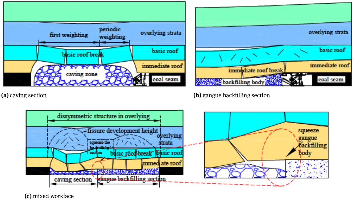
High gas low permeability coal seam has always been a technical problem that threaten coal safe mining [1]. In order to effectively solve this problem, domestic and foreign scholars have proposed the protective layer mining method, that is, the protective layer is mined first, and then the gas in the protected layer is extracted by the crack zone of the protective layer [2]. After the gas content reaches the required level, the protected layer will be mined [3]. When the protective layer is a rock or a near-rock coal seam, a large amount of gangue will be produced when such a protective layer is mined [4]. The gangue contains a large amount of toxic and harmful substances. If it is discharged to the surface, it will not only pollute the surface soil and water source, but also release harmful gases, which will seriously threaten the ecology of the mining area and the safety of residents [5, 6]. With the increase of the awareness of environmental protection, China gradually bans gangue ground discharge of the gangues. The gangue backfilling is the main technical means to solve the gangue stacking [7]. In order to ensure coal production and handle the gangue, domestic scholars propose a new mixed workface combining the fully mechanized gangue backfilling mining method with the traditional fully mechanized caving mining method. This new mixed mining method is an attempt and innovation in the application of the gangue backfilling and caving coal mining. This method will transport the gangue generated from the protection layer or underground excavation to the gangue storage chamber. Then, the gangue in the storage chamber is transported to the backfilling section of the mixed workface through the underground continuous conveying system. The backfilling section and the caving section of the mixed work-face are arranged by different hydraulic supports and applied with different goaf treatment methods. So both sections could complete cooperatively the coal mining and gangue backfilling. The system layout of the mixed work-face is shown in Figure 1.
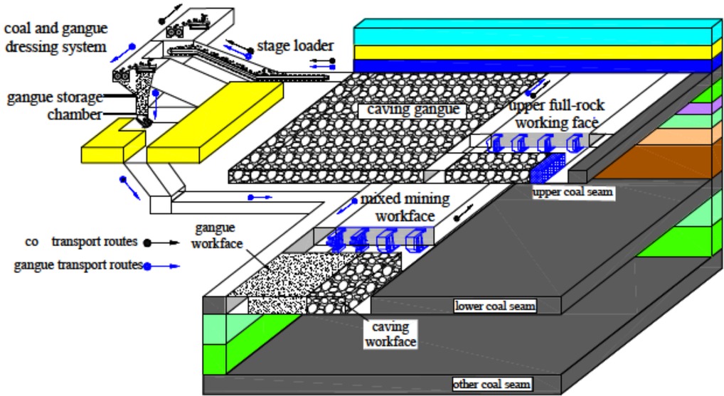
System layout of the mixed workface.
According to whether the goaf is backfilled with gangue and what kinds of hydraulic supports to be used, the mixed workface is divided into a backfilling section, a transition section and a caving section. Key equipment such as the backfilling hydraulic supports and the rear scraper conveyor suspended at the rear canopy of the backfilling hydraulic supports are arranged in the backfilling section. Under the backfilling hydraulic supports, the rear scraper conveyor discharges the gangue and goaf is backfilled. The caving section adopts the caving method for the goaf management. So the roof is naturally collapsed, and the workface is arranged with traditional hydraulic supports. A shearer and scraper conveyor are shared between the backfilling section and the caving section for the coal mining. A transitional hydraulic support is arranged at the connection between the backfilling section and the caving section to achieve a smooth transition. Equipment such as crushers, transfer machines and belt conveyors are arranged in the transportation roadway to transport coal to the surface, while belt conveyors, transfer machines and other equipment are arranged in the auxiliary transportation roadway to transport the gangue to the backfilling section. The mixed workface layout is shown in Figure 2.
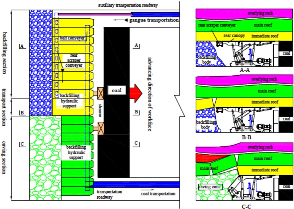
Layout of the mixed workface.
At present, the study on design and application of the mixed workface mainly focuses on the mining technology, gas control and roof collapse characteristics [8]. In terms of the mining technology, the rock mining process, the gangue backfilling process and the coal mining process were optimized, so that the three cooperate with each other to meet the requirements of coal output and gangue treatment [9, 10, 11]. In the aspect of gas control, it was analyzed that the effects of the thickness of the protective layer and the gas extraction process on the gas liberation of coal seams [12, 13]. In terms of roof collapse characteristics, theoretical analysis, numerical simulation and physical simulation were used to study the influence of the backfilling rate on the roof collapse characteristics of the caving section and the backfilling section [14, 15].
The above studies have played a significant role in the mining principle, technical research and application of mixed workface. However, due to the difference in the management method of the goaf roof behind the backfilling section and the caving section, the roof vertical stress in the transition section will suddenly increase, which requires special consideration. The working resistance and numbers of the hydraulic support of the transition section also need to be determined. These research and analysis can provide theoretical guidance for the selection and design of transitional supports in the transition section.
Based on the systems layout of the mixed workface, the physical simulation is used to study the fracture and movement characteristics of the overburden strata in the backfilling section and caving sections. The definition of the transition section of the mixed workface is also given. Then, the numerical simulation software ABAQUS is used to establish the numerical model for the transition section length of the mixed workface. It is used to analyze the influence of the advancing length and the backfilling section length on the length of the transition section. Finally, engineering test is carried out in the Ji15-31010 mixed work-face of Pingdingshan No. 12 Mine. The rationality of the transition section length of the mixed workface is verified through the on-site measured working resistance of the hydraulic supports.
2 The movement and fracture characteristics of the overburden strata of the mixed workface
Due to the difference in the goaf treatment for the backfilling section and the caving section, the fracture and movement of the overburden strata of the backfilling section and the caving section are different. As a result, the vertical
stress rapid growth at the transition section of the mixed workface. Based on the geological conditions of the Ji15-31010 mixed workface of Pingdingshan No.12 Coal Mine, the physical simulation is used to analyze the fracture and movement law of the rock stratum. The geometry ratio of experimental simulation is 1:100, the model length and width is 2.5m× 0.3 m, and the model height is set to 1.50 m. The model first mines the overburden protective layer and then the mixed workface. The gangue of the mixed work-face uses similar material to simulate the gangue. The experiment system is mainly composed of three parts: model frame, external loading system and test system. According to the ratio of the length of the backfilling section to that the caving section, 4 models were designed, that is, 4 schemes, the length ratios of which are 2:1, 1.2:1, 1:1 and 1:2, respectively, shown in Table 1.
Physical simulation schemes.
| Schemes | Length ratio | Backfilling section length /cm | Caving section length /cm |
|---|---|---|---|
| 1 | 2:1 | 145 | 73 |
| 2 | 1.2:1 | 120 | 98 |
| 3 | 1:1 | 109 | 109 |
| 4 | 1:2 | 73 | 145 |
The basic mechanical parameters of each rock stratum in the physical model are shown in Table 2, and the material proportion parameters are shown in Table 3.
The mechanical parameters of the rock and coal layers in the physical simulation.
| No. | Rock stratum | Real Thickness/m | Model Thickness /cm | Compressive Strength /MPa | Simulated Strength /Kpa |
|---|---|---|---|---|---|
| 1 | Siltstone | 25 | 25 | 16.0 | 184.61 |
| 2 | Sandy mudstone | 15 | 15 | 14.0 | 161.53 |
| 3 | Fine sandstone | 10 | 10 | 32.0 | 369.22 |
| 4 | Mudstone | 10 | 10 | 14.0 | 161.53 |
| 5 | Fine sandstone | 8 | 8 | 32.0 | 369.22 |
| 6 | Mudstone | 12 | 12 | 14.0 | 161.53 |
| 7 | Coarse sandstone | 6.0 | 6.0 | 25.0 | 288.45 |
| 8 | Fine sandstone | 6.0 | 6.0 | 35.0 | 403.83 |
| 9 | Siltstone | 5.0 | 5.0 | 13.0 | 149.99 |
| 10 | Ji14 coal seam | 0.5 | 0.5 | 10.0 | 110.52 |
| 11 | Sandy mudstone | 6.5 | 6.5 | 15.0 | 173.07 |
| 12 | Fine sandstone | 2.5 | 2.5 | 35.0 | 403.83 |
| 13 | Sandy mudstone | 4.5 | 4.5 | 14.0 | 161.53 |
| 14 | Ji15 coal seam | 3.2 | 3.2 | 9.0 | 103.84 |
| 15 | Mudstone | 0.5 | 0.5 | 16.0 | 184.61 |
| 16 | Fine sandstone | 4.7 | 4.7 | 32.0 | 369.22 |
| 17 | Limestone | 4.2 | 4.2 | 20.0 | 230.76 |
| 18 | Fine sandstone | 10 | 10 | 32.0 | 369.22 |
| 19 | Sandstone | 15 | 15 | 32.0 | 369.22 |
The mass of different materials in the physical simulation.
| No. | Rock stratum | Thickness /m | Total dry weight /kg | Sand /kg | Calcium carbonate /kg | Gypsum /kg | Water/kg |
|---|---|---|---|---|---|---|---|
| 1 | Siltstone | 25 | 225.00 | 187.50 | 11.25 | 26.25 | 28.13 |
| 2 | Sandy mudstone | 15 | 135.00 | 115.71 | 5.79 | 13.50 | 16.88 |
| 3 | Fine sandstone | 10 | 90.00 | 67.50 | 6.75 | 15.75 | 11.25 |
| 4 | Mudstone | 10 | 90.00 | 77.14 | 3.86 | 9.00 | 11.25 |
| 5 | Fine sandstone | 8 | 72.00 | 54.00 | 5.40 | 12.60 | 9.00 |
| 6 | Mudstone | 12 | 108.00 | 92.57 | 4.63 | 10.80 | 13.50 |
| 7 | Coarse sandstone | 6.0 | 54.00 | 40.50 | 4.05 | 9.45 | 6.75 |
| 8 | Fine sandstone | 6.0 | 54.00 | 40.50 | 4.05 | 9.45 | 6.75 |
| 9 | Siltstone | 5.0 | 45.00 | 36.00 | 4.50 | 4.50 | 5.63 |
| 10 | Ji14 coal seam | 0.5 | 4.50 | 3.75 | 0.23 | 0.53 | 0.56 |
| 11 | Sandy mudstone | 6.5 | 58.50 | 50.14 | 2.51 | 5.85 | 7.31 |
| 12 | Fine sandstone | 2.5 | 22.50 | 16.88 | 1.69 | 3.94 | 2.81 |
| 13 | Sandy mudstone | 4.5 | 40.50 | 34.71 | 1.74 | 4.05 | 5.06 |
| 14 | Ji15 coal seam | 3.2 | 28.80 | 25.20 | 1.80 | 1.80 | 3.60 |
| 15 | Mudstone | 0.5 | 4.50 | 3.75 | 0.23 | 0.53 | 0.56 |
| 16 | Fine sandstone | 4.7 | 42.30 | 31.73 | 3.17 | 7.40 | 5.29 |
| 17 | Limestone | 4.2 | 37.80 | 30.24 | 2.27 | 5.29 | 4.73 |
| 18 | Fine sandstone | 10 | 90.00 | 67.50 | 6.75 | 15.75 | 11.25 |
| 19 | Sandstone | 15 | 135.00 | 101.25 | 10.13 | 23.63 | 16.88 |
2.1 Movement characteristics of overburden strata
In order to study the movement law of rock strata during mining the mixed workface, the non-contact full field strain measurement system Vic-2D was used for recording and processing data. The overburden strata movement and the immediate roof subsidence of the mixed workface were investigated under the length ratio of 2:1, 1.2:1, 1:1 and 1:2, as shown in Figure 3.
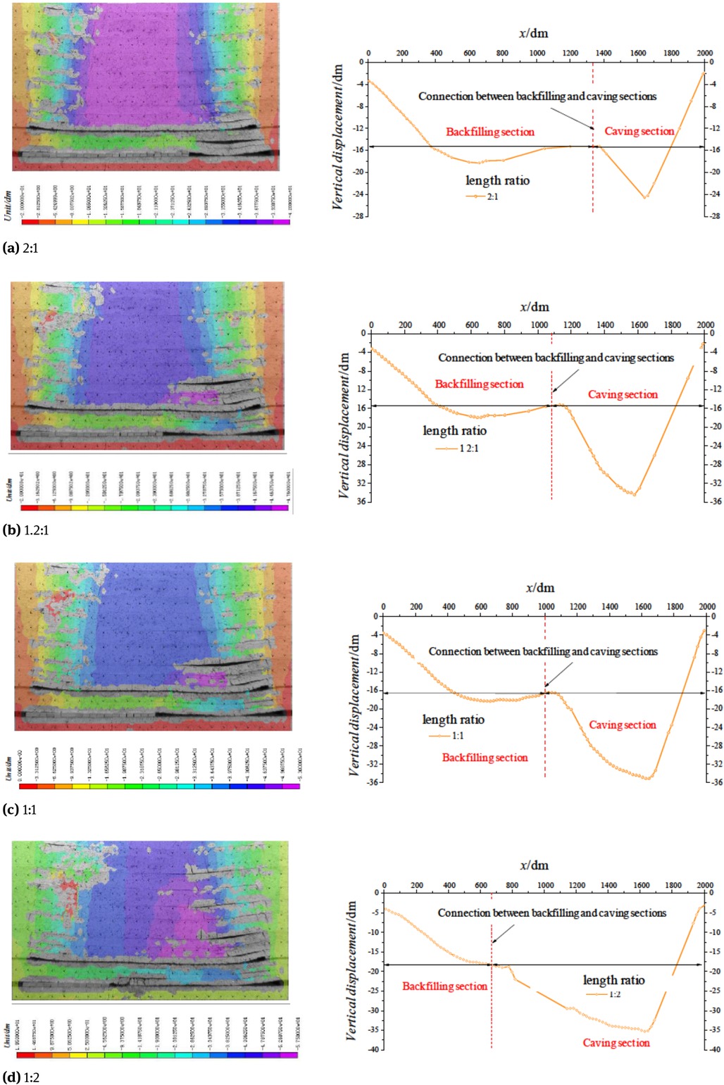
Characteristics of overburden strata movement in the mixed workface.
It can be seen from Figure 3 that after the mixed work-face was mined, the overburden strata movement characteristics have obvious differences with the change of the length ratio, and have the following main rules:
When the length ratio is between 2:1 and 1.2:1, the maximum roof vertical displacement in the caving section is 2.25 times of the that in backfilling section.
The overburden strata in the caving section show the “three zone” law, which includes the caving zone, fractured zone and the bending subsidence zone. However, the backfilling section is mainly composed of the bending subsidence zone and the crack zone, while the caving zone is only weakly developed. The roof has obvious step-like sinkage in the transition section.
When the length ratio is between 1:1 and 1:2, the roof sinkage of the caving section is further increased. The roof vertical displacement tends to change in the “basin” shape, indicating that the control effect of the gangue in the goaf on the overburden strata is weakened, and the mining pressure appear to be intensified.
2.2 Fracture development characteristics of the overburden strata
The law of mining pressure in mixed workface is closely related to the development characteristics of overburden fracture. The research focuses on the fracture development characteristics of the rock strata in the mixed work-face when the backfilling section and the caving section length ratios are 2:1, 1.2:1, 1:1 and 1:2, respectively, as shown in Figure 4.
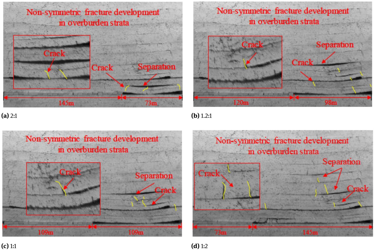
Characteristics of fracture development in overburden strata of the mixed workface under different length radio.
It can be seen from Figure 4 that the development of fractures in the overburden strata of the mixed workface has the following main rules:
When the length ratio is between 2:1 and 1.2:1, the height of the fracture zone increases with the decrease of the backfilling section, and the separation phenomenon is obvious. The maximum heights of the fracture zone are 7 m and 15 m, respectively. There exists the caving zone, fractured zone and the bending subsidence zone in the roof of the caving section, while the backfilling section is mainly composed of bending subsidence zone and fractured zone, and the caving phenomenon is weak.
When the length ratio is between 1:1 and 1:2, the support of the gangue for the overburden strata is weakened, and the cracks are further developed with a height of 17 m and 36 m, respectively. At this time, the movement of the roof rock strata is obviously intensified, and the mining pressure is higher.
The roof has an obvious step-like sinkage in the transition section, so there may be a sudden increase in the roof vertical stress in the transition section.
3 Definition of the transition section of the mixed workface
Through the physical simulation, it can be seen that the movement and fracture characteristics of the overburden strata in different sections of the mixed workface are different. In the caving section, the roof of the goaf is naturally collapsed, and the overburden movement is represented by the traditional “three-zone” law, as shown in Figure 5(a). However, due to the supporting effect of the gangue backfilling body, the overburden strata are mainly composed of the bending subsidence zone and the fractured zone in the goaf of the backfilling section, while the caving zone is relatively weak, as shown in Figure 5(b). Under the different movement and fracture characteristics of the overburden strata, overburden strata of the transition section need to sink synergistically, which leads to the occurrence of phenomenon that the roof squeezes the gangue in backfilling section, as shown in Figure 5(c). As a result, the roof vertical stress surges in the transition section. This higher vertical stress places new demands on the selection and design of hydraulic supports in the transition section. On the one hand, it is necessary to consider the number of hydraulic supports in the transition section, and on the other hand, the working resistance of the hydraulic support needs to be considered. When hydraulic supports that exceed 1.2 times the average working resistance, special considerations are often required. Therefore, in the transition section, the zone where the roof vertical stress is higher than 1.2 times the average roof vertical stress of the backfilling section is defined as the transition section of the mixed workface.
Layout of the mixed workface.
4 Analysis of factors affecting the transition section length of mixed workface
The gangue in the backfilling section is directly sourced from the protective layer and roadway driving, that is, the total amount of gangue source is certain. Therefore, the backfilling section length is strictly affected by its backfilling height. Therefore, two factors, the workface advancing length and backfilling section length, are considered.
4.1 Numerical model
4.1.1 Numerical simulation schemes
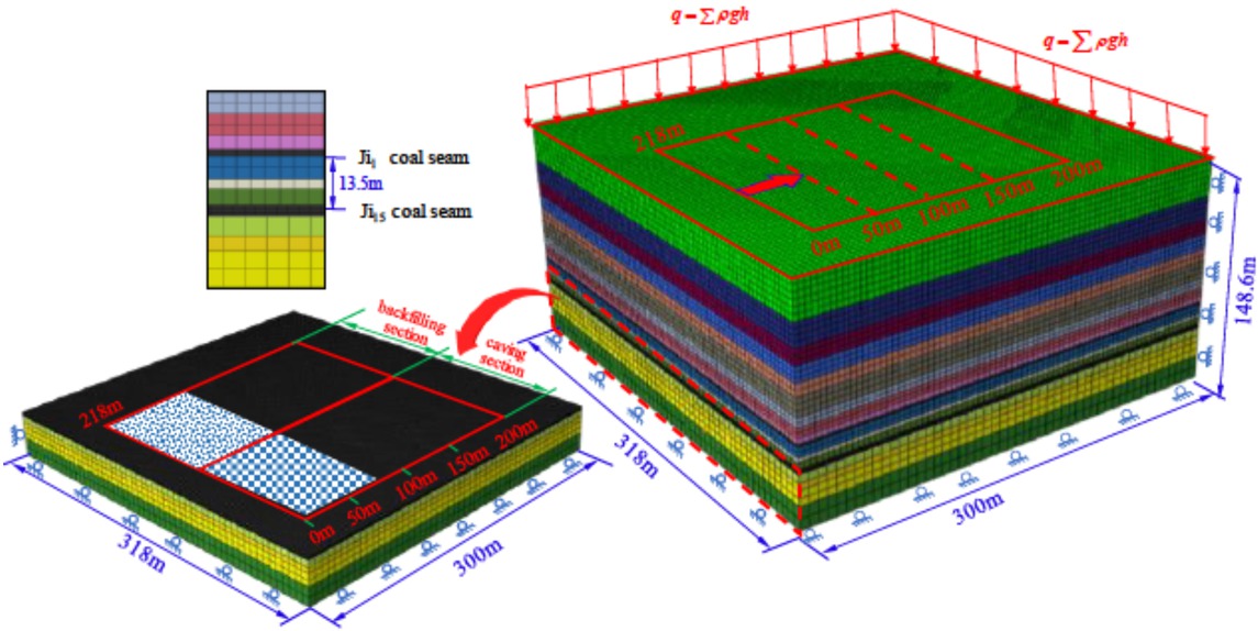
Considering the actual engineering background of the Ji15-31010 mixed workface of Pingdingshan No. 12 Mine, the protective layer needs to be mined first. Therefore, the protective layer must be excavated before the Ji15-31010 mixed workface. Theworkface length of the protective layer is 218 m, the excavation height is 1.9 m, the continuous advancing length is 200 m. The displacement and stress state after the excavation of the protective layer is taken as the initial simulation condition for mining the mixed workface. At the same time, the following three factors must be considered when changing the backfilling section length of the mixed workface:
The minimum length of the backfilling section is 103 m which is estimated from the upper layer gangue supply capacity.
At present, the maximum length of backfilling work-face in actual engineering practice is 150 m.
Considering that the suspension length of rear scraper conveyor is usually 0.4 m, the natural stacking height of gangue is up to 2.8 m without the action of the compacting mechanism.
Considering above three factors, two numerical analysis schemes are determined. In the scheme I, when the backfilling section length is 103 m, the influence of the advancing length of the workface on the transition section length is studied. The scheme II studies the influence of the backfilling section length on the transition section length when the mixed workface is advanced by 200 m. The specific schemes are shown in Table 4.
Numerical simulation schemes.
| Scheme | Backfilling | Caving | Stacking | Stacking | Natural stacking |
|---|---|---|---|---|---|
| section | section | height/m | method | ||
| length/m | length/m | ||||
| I | 103 | 115 | 2.80 |  | |
| II | 109 | 109 | 2.65 | Natural | |
| 120 | 98 | 2.40 | stacking | ||
4.2 Basic parameters of the model
According to the layout of the workface of Ji15-31010 and the histogram of coal and rock layers and the mechanical parameters of the laboratory coal and rock, as shown in Figure 4, a numerical model with a length, width and height of 318 m× 300 m× 148.6 mis established, as shown in Figure 6. The workface length is 218 m, the average coal seam height is 3.2 m, and the advancing length is 200 m. The horizontal displacement of the four sides of the model is constrained, while bottom of the model is constrained on the horizontal and vertical displacements [16, 17]. The gravity acceleration of 9.8 m/s2 is applied to the entire model, and a uniform load of 25MPa is applied on the top boundary to replace the 1000 m thick overburden weight [18, 19]. At the same time, in order to eliminate the influence of boundary on model excavation, 50 m coal pillars are left at the four sides of the model [20, 21]. The specific rock formation parameters of the model are shown in Table 5.
Numerical model of the mixed workface.
Mechanical properties of coal and rock layers.
| Parameter | ||||||
|---|---|---|---|---|---|---|
| Histogram | Thickness /m | Elastic modulus E/GPa | Poisson’s ratio μ | Cohesion c/MPa | Internal friction angle φ/∘ | Volumetric weight 𝛾/kN·m−3 |
| Siltstone | 25 | 16.0 | 0.27 | 4.2 | 31 | 24.0 |
| Sandy mudstone | 15 | 14.0 | 0.34 | 5.3 | 27 | 24.1 |
| Fine sandstone | 10 | 32.0 | 0.30 | 6.5 | 28 | 23.5 |
| Mudstone | 10 | 14.0 | 0.24 | 1.1 | 29 | 23.6 |
| Fine sandstone | 8 | 32.0 | 0.31 | 6.5 | 31 | 24.5 |
| Mudstone | 12 | 14.0 | 0.24 | 1.3 | 29 | 25.3 |
| Coarse Sandstone | 6.0 | 25.0 | 0.31 | 7.5 | 28 | 26.0 |
| Fine sandstone | 6.0 | 35.0 | 0.32 | 6.3 | 32 | 25.1 |
| Siltstone | 5.0 | 13.0 | 0.32 | 4.8 | 31 | 26.1 |
| Ji14 coal seam | 0.5 | 10.0 | 0.33 | 2.0 | 26 | 13.5 |
| Sandy mudstone | 6.5 | 15.0 | 0.29 | 4.9 | 31 | 25.1 |
| Fine sandstone | 2.5 | 35.0 | 0.31 | 5.3 | 29 | 24.3 |
| Sandy mudstone | 4.5 | 14.0 | 0.32 | 4.8 | 28 | 24.1 |
| Ji15 coal seam | 3.2 | 9.0 | 0.27 | 1.6 | 30 | 14.0 |
| Fine sandstone | 5.2 | 32.0 | 0.35 | 5.3 | 28 | 23.5 |
| Limestone | 4.2 | 20.0 | 0.30 | 4.2 | 27 | 24.1 |
| Fine sandstone | 10 | 32.0 | 0.31 | 6.2 | 26 | 25.0 |
4.3 Advancing length of the mixed workface
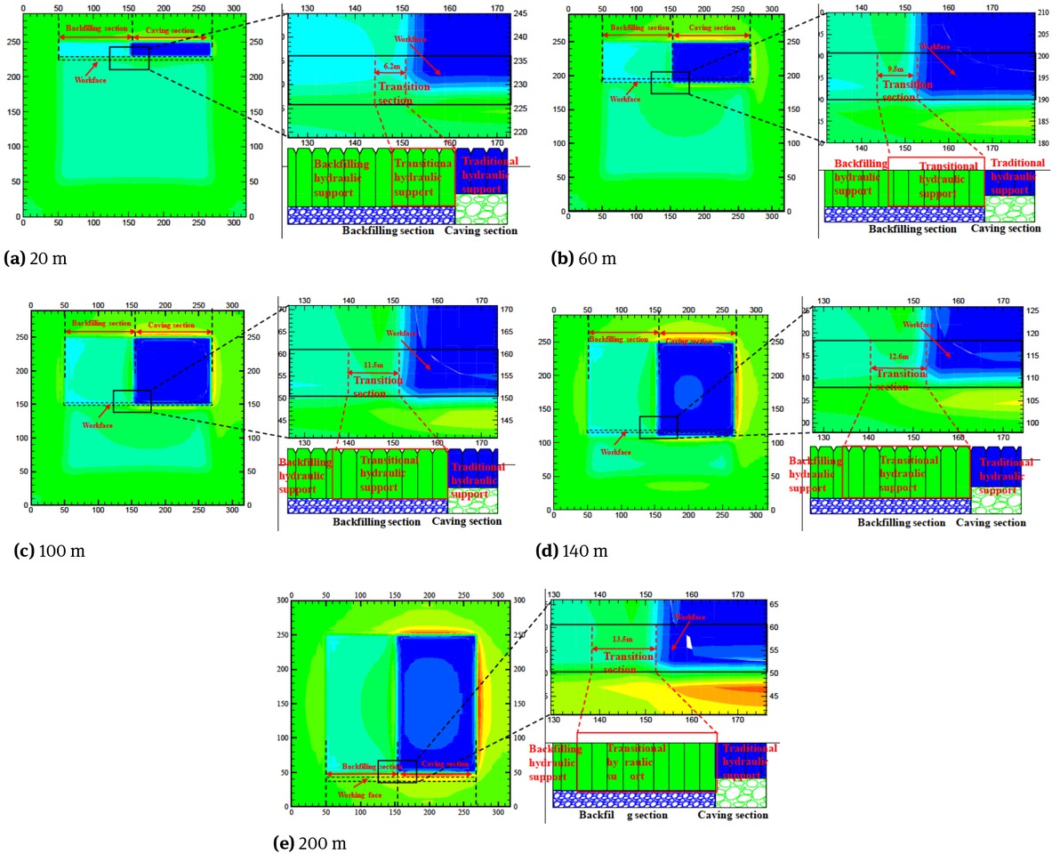
In order to directly reflect the length of the transition section in the mixed workface, 1.2 times of the roof vertical stress of the backfilling section as a special label with the green color, when setting the stress nephogram label. By comparing the color of roof vertical stress near the transition section, the length of the transition section is directly indicated in the stress nephogram.
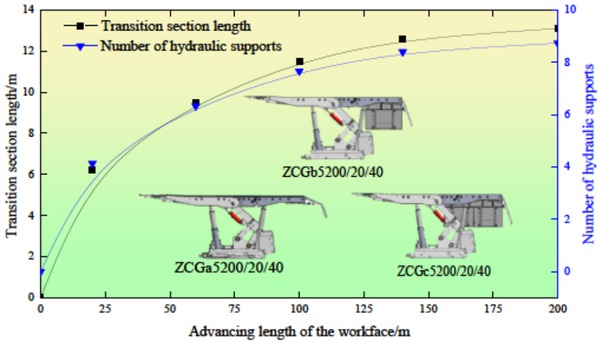
From the scheme I, the lengths of the transition sections in the mixed workface, when the workface is advanced by 20 m, 60 m, 100 m, 140 m and 200 m, are extracted respectively, as shown in Figure 7. Also, the variation of the length of the transition section and the number of hydraulic supports in the transition section versus the advancing length of the mixed workface are drawn in Figure 8.
The transition section length under the different advancing length of the workface.
The variation of the transition section length with the advancing length of the workface.
It can be seen from Figure 7~8 that:
When the workface is advanced by 20m, 60m, 100m, 140m and 200m, the length of the transition section in the mixed workface is 6.2m, 9.5m, 11.5m, 12.6m and 13.5m, respectively. If the width of the hydraulic support in the transition section is 1.5 m, the number of corresponding hydraulic supports is 4~5, 6~7, 7~8, 8~9 and 8~9.
As the workface advances, the length of the transition section in the mixed workface gradually increases, and eventually stabilizes at 13.5m. If the width of the hydraulic support in the transition section is 1.5m, it corresponds to the 8~9 hydraulic supports.
4.4 Length of the backfilling section
The length of the backfilling section is the key parameter for the design of mixed workface. In scheme II, when the workface is advanced by 200 m, it is extract that the transition section lengths of the mixed workface corresponding to the length of the gangue backfilling section of 145 m, 120 m, 109mand 103 m, respectively, as shown in Figure 9. In addition, the relationship between backfilling section length and the transition section length, and relationship between backfilling section length and the number of hydraulic supports in the transition section are drawn in Figure 10.
The transition section length under different the backfilling section length.
The variation of transition section length with backfilling section length.
It can be seen from Figure 9~10 that:
When the backfilling section length is 145 m, 120 m, 109 m and 103 m, the transition section length of the mixed workface is 8.7m, 12.2 m, 13.2m and 13.5m, respectively. If the width of the hydraulic support in the transition section is 1.5m, the number of corresponding hydraulic supports is 4~6, 8~9, 8~9 and 9.
With the decrease of the backfilling section length, the transition section length gradually increases, and eventually stabilizes at 13.5m. If the width of the hydraulic support in the transition section is 1.5m, it corresponds to the 8~9 hydraulic support.
5 Engineering practice
5.1 Engineering overview of the Ji15-31010 work surface
5.1.1 System layout of the workface
The Ji15-31010 mixed workface of Pingdingshan No.12 Coal Mine is located at the Pingdingshan City, Henan province, china. The advancing length of the workface is 929 m and the length of the mixed workface is 218 m with 120 m length of the backfilling section and 98 m length of caving section, respectively. The average thickness of coal seam is 3.2 m and the bury depth is 1005~1166 m. The average dip angle of the coal seam is 5∘. The system layout of the Ji15-31010 mixed workface is shown in Figure 11.
System layout of the Ji15-31010 mixed workface.
5.1.2 Equipment design for the mixed workface
The number of hydraulic support in the transition section is the main problem of the design for the Ji15-31010 mixed workface. When the main roof of the mixed workface is broken for the firstly time, the mining pressure of the work-face is obvious, and then decreases. Therefore, it is considered that the mixed workface has the longest transition section when the main roof is firstly broken. According to the statistical law of mining pressure in the workface of Pingdingshan No. 12 Coal Mine, firstly broken length of the main roof is about 20~40 m. At the same time, considering a certain safety factor, the broken length of the main roof is set to 40~60 m. From the numerical calculation, when advanced to about 50~60 m, the transition section length is about 6~8 m, corresponding to 4~6 hydraulic supports of width 1.5 m. At the same time, considering the ventilation problem of the transition section and that the support strength of the hydraulic support in the transition section increases from 0.50 MPa to 0.80~0.85 MPa, 4 transitional hydraulic supports are used for the mixed workface. Based on the geological conditions of the Ji15-31010 mixed work-face, other mechanical equipment such as coal shear, front scraper conveyor, etc., is selected. The main equipment of the Ji15-31010 mixed workface is shown in Table 6.
Main equipment list of mixed workface.
| Index No. | Equipment name | Model No. | Quantity | |
|---|---|---|---|---|
| 1 | Coal shear | NG400/940WD | 1 |  |
| 2 | Front Scraper conveyer | SGZ-800/800WS | 1 | |
| 3 | Stage loader for coal transportation | SZZ764/200 | 1 | |
| 4 | Dual-column fully mechanized mining support | ZY6800/20/40 | 76 |  |
| 5 | Backfilling support | ZC5200/20/40 | 66 | |
| 6 | Backfilling transition support A | ZCGa5200/20/40 | 2 | |
| 7 | Backfilling transition support B | ZCGb5200/20/40 | 1 | 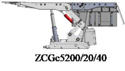 |
| 8 | Backfilling transition support C | ZCGc5200/20/40 | 1 | |
| 9 | Rear Scraper conveyer | SGZ764/2×200 | 1 | |
| 10 | Belt conveyor | DTL80/50/30 | 1 |
5.2 The measurement for length of the transition section
5.2.1 Monitoring scheme
In order to monitor the transition section length of the Ji15-31010 mixed workface, as shown in Figure 12, the hydraulic support working resistance monitors are arranged on supports No. 1, 14, 27, 40, 53, 65, 66, 67, 68, 69, 70, 81, 94, 107, 120, 133, 145, respectively. Among them, there are 6 single-channel working resistance monitors and 11 double-channel working resistance monitors, totaling 17 monitors. They are used to dynamically monitor the working resistance of hydraulic supports, while using underground data collectors to save and collect the monitoring data. The transition section length of the mixed workface during the mining process can be obtained via the working resistance of hydraulic supports.

The monitoring schemes of the working resistance of hydraulic supports in the mixed workface.
5.2.2 Transition section length
In order to analyze the variation of the transition section length at different advancing length of the workface, whenthe mixed workface is advanced to 10 m, 20 m, 40m and 60 m, the working resistance peaks within 24 hours of the hydraulic supports are extracted. As shown in Figure 13, the transition section length is given by comparing the peak value of the working resistance of the hydraulic support.
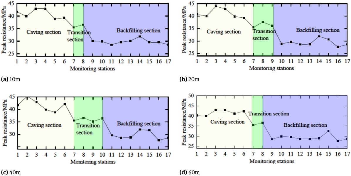
Peak resistance distribution of hydraulic supports at each station.
It can be seen from Figure 13 that:
By comparing and analyzing the working resistance of the hydraulic support in the transition section of the mixed workface, one can see that the number of hydraulic support within the transition section of the mixed workface is increased from 2 to 4 when the workface is advanced from 10 m to 40 m, and is reduced to 2 when advanced to 60 m.
By comparing the number of hydraulic supports in the transition section of the mixed workface, it can be concluded that the initial break of the main roof occurs between 40 m and 60 m. Therefore, the number of hydraulic supports is 4 and the maximum length of the transition section is about 6.0 m.
6 Conclusion
Based on the analysis of the system layout of mixed work-face, the fracture and movement characteristics of the overburden strata of the mixed workface were studied by physical simulation. Also, the concept of transition section of the mixed workface was proposed. The following conclusions can be drawn:
The roof in the caving section of the mixed workface is naturally collapsed, and the overburden movement is represented by the traditional “three-zone” law. However, the overburden strata of the backfilling section are mainly composed of bending subsidence zone and the fractured zone, while the caving zone is relatively weak.
The influence the workface advancing length and backfilling section length on the of transition section length of mixed workface was studied and analyzed. The results showed that, as the advancing length of the workface increases and the backfilling section length decreases, the transition section length of the mixed workface increases continuously and eventually stabilizes. Its range of variation is 6.2~13.5 m, corresponding to 4~9 hydraulic supports with 1.5 m width.
Itwas obtained from the monitoring data of the working resistance of hydraulic supports in the Ji15-31010 mixed workface of Pingdingshan No. 12 Mine that: as the workface was advanced from 10 m to 40 m, the number of hydraulic support in the transition section was increased from 2 to 4, which was then reduced to 2 when advanced to 60 m. This indicated that the initial break of the basic roof occurred between 40~60 m of the mixed workface. The maximum length of the transition section corresponds to 4 hydraulic supports.
Acknowledgement
This work is supported by the Independent Research Project of State Key Laboratory of Coal Resources and Safe Mining, CUMT (SKLCRSM18X006); National Natural Science Foundation of China (51604262, 51574055). The authors gratefully acknowledge the financial support from the organization mentioned above.
References
[1] Xu M, Gao J, Wang G, Wang S. The rule of methane effusion of full-mechanized top coal caving in thick, hard and high-gas seam2007.Suche in Google Scholar
[2] Jiang H, Cao Y, Huang P, Fang K, Li B. Characterisation of coal-mine waste in solid backfill mining in China. Mining Technology 2015;124:56-63.10.1179/1743286315Y.0000000002Suche in Google Scholar
[3] Li D. Underground hydraulic mining of thin sub-layer as protective coal seam in coal mines. International Journal of Rock Mechanics and Mining Sciences 2014;67:145-54.10.1016/j.ijrmms.2014.01.014Suche in Google Scholar
[4] Vargas T, Rojas F, Bahamondez C, et al. Physical and chemical transformations of gangue materials during leaching of copper sulphides, and their influence on copper leaching kinetics. Journal of the Southern African Institute of Mining and Metallurgy 2017;117:727-30.10.17159/2411-9717/2017/v117n8a1Suche in Google Scholar
[5] Zhou J, Liu Y, Du C, Wang F. Experimental Study on Crushing Characteristic of Coal and Gangue under Impact Load. International Journal of Coal Preparation and Utilization 2015;36:272-82.10.1080/19392699.2015.1114478Suche in Google Scholar
[6] Zhou N, Han XL, Zhang JX, Li M. Compressive deformation and energy dissipation of crushed coal gangue. Powder Technology 2016;297:220-8.10.1016/j.powtec.2016.04.026Suche in Google Scholar
[7] Zhang J, Li M, Liu Z, Zhou N. Fractal characteristics of crushed particles of coal gangue under compaction. Powder Technology 2017;305:12-8.10.1016/j.powtec.2016.09.049Suche in Google Scholar
[8] Zhang J, Zhang Q, Spearing AJS, Miao X, Guo S, Sun Q. Green coal mining technique integrating mining-dressing-gas draining-backfilling-mining. International Journal of Mining Science and Technology 2017;27:17-27.10.1016/j.ijmst.2016.11.014Suche in Google Scholar
[9] Zhang D, Fan G, Liu Y, Ma L. Field trials of aquifer protection in longwall mining of shallow coal seams in China. International Journal of Rock Mechanics and Mining Sciences 2010;47:908-14.10.1016/j.ijrmms.2010.06.018Suche in Google Scholar
[10] Zhang Q, Zhang JX, Kang T, Sun Q, Li WK. Mining pressure monitoring and analysis in fully mechanized backfilling coal mining face-A case study in Zhai Zhen Coal Mine. Journal of Central South University 2015;22:1965-72.10.1007/s11771-015-2716-2Suche in Google Scholar
[11] Li ZQ, Xue YG, Li SC, et al. Deformation features and failure mechanism of steep rock slope under the mining activities and rainfall. Journal of Mountain Science 2017;14:31-45.10.1007/s11629-015-3781-6Suche in Google Scholar
[12] Yang W, Lin BQ, Gao YB, et al. Optimal coal discharge of hydraulic cutting inside coal seams for stimulating gas production: A case study in Pingmei coalfield. J Nat Gas Sci Eng 2016;28:379-88.10.1016/j.jngse.2015.12.004Suche in Google Scholar
[13] Zou J, Chen W, Jiao Y-Y. Numerical simulation of hydraulic fracture initialization and deflection in anisotropic unconventional gas reservoirs using XFEM. J Nat Gas Sci Eng 2018;55:466-75.10.1016/j.jngse.2018.04.033Suche in Google Scholar
[14] Guo J, Feng G, Wang P, Qi T, Zhang X, Yan Y. Roof Strata Behavior and Support Resistance Determination for Ultra-Thick Longwall Top Coal Caving Panel: A Case Study of the Tashan Coal Mine. Energies 2018;11:1041.10.3390/en11051041Suche in Google Scholar
[15] He C, Xu J, Wang F, Wang F. Movement Boundary Shape of Overburden Strata and Its Influencing Factors. Energies 2018;11:742.10.3390/en11040742Suche in Google Scholar
[16] Barton N, Pandey SK. Numerical modelling of two stoping methods in two Indian mines using degradation of c and mobilization of φ based on Q-parameters. International Journal of Rock Mechanics and Mining Sciences 2011;48:1095-112.10.1016/j.ijrmms.2011.07.002Suche in Google Scholar
[17] Nemcik J, Ma S, Aziz N, Ren T, Geng X. Numerical modelling of failure propagation in fully grouted rock bolts subjected to tensile load. International Journal of Rock Mechanics and Mining Sciences 2014;71:293-300.10.1016/j.ijrmms.2014.07.007Suche in Google Scholar
[18] Si G, Shi J-Q, Durucan S, et al. Monitoring and modelling of gas dynamics in multi-level longwall top coal caving of ultra-thick coal seams, Part II: Numerical modelling. International Journal of Coal Geology 2015;144-145:58-70.10.1016/j.coal.2015.04.009Suche in Google Scholar
[19] Li W, Bai J, Peng S,Wang X, Xu Y. Numerical Modeling for Yield Pillar Design: A Case Study. Rock Mechanics and Rock Engineering 2014;48:305-18.10.1007/s00603-013-0539-8Suche in Google Scholar
[20] Shabanimashcool M, Li CC. Numerical modelling of longwall mining and stability analysis of the gates in a coal mine. International Journal of Rock Mechanics and Mining Sciences 2012;51:24-34.10.1016/j.ijrmms.2012.02.002Suche in Google Scholar
[21] Wenxue C. Analysis on relationship between stress and drill cutting weight using numerical modeling – A case study in Jinjiazhuang coal mine. Safety Science 2012;50:923-6.10.1016/j.ssci.2011.08.002Suche in Google Scholar
© 2019 Y. Tai et al., published by De Gruyter
This work is licensed under the Creative Commons Attribution 4.0 Public License.
Artikel in diesem Heft
- Regular Articles
- 2D Seismic Interpretation of the Meyal Area, Northern Potwar Deform Zone, Potwar Basin, Pakistan
- A new method of lithologic identification and distribution characteristics of fine - grained sediments: A case study in southwest of Ordos Basin, China
- Modified Gompertz sigmoidal model removing fine-ending of grain-size distribution
- Diagenesis and its influence on reservoir quality and oil-water relative permeability: A case study in the Yanchang Formation Chang 8 tight sandstone oil reservoir, Ordos Basin, China
- Evaluation of AHRS algorithms for Foot-Mounted Inertial-based Indoor Navigation Systems
- Identification and evaluation of land use vulnerability in a coal mining area under the coupled human-environment
- Hydrocarbon Generation Potential of Chia Gara Formation in Three Selected Wells, Northern Iraq
- Source Analysis of Silicon and Uranium in uranium-rich shale in the Xiuwu Basin, Southern China
- Lithologic heterogeneity of lacustrine shale and its geological significance for shale hydrocarbon-a case study of Zhangjiatan Shale
- Characterization of soil permeability in the former Lake Texcoco, Mexico
- Detrital zircon trace elements from the Mesozoic Jiyuan Basin, central China and its implication on tectonic transition of the Qinling Orogenic Belt
- Turkey OpenStreetMap Dataset - Spatial Analysis of Development and Growth Proxies
- Morphological Changes of the Lower Ping and Chao Phraya Rivers, North and Central Thailand: Flood and Coastal Equilibrium Analyses
- Landscape Transformations in Rapidly Developing Peri-urban Areas of Accra, Ghana: Results of 30 years
- Division of shale sequences and prediction of the favorable shale gas intervals: an example of the Lower Cambrian of Yangtze Region in Xiuwu Basin
- Fractal characteristics of nanopores in lacustrine shales of the Triassic Yanchang Formation, Ordos Basin, NW China
- Selected components of geological structures and numerical modelling of slope stability
- Spatial data quality and uncertainty publication patterns and trends by bibliometric analysis
- Application of microstructure classification for the assessment of the variability of geological-engineering and pore space properties in clay soils
- Shear failure modes and AE characteristics of sandstone and marble fractures
- Ice Age theory: a correspondence between Milutin Milanković and Vojislav Mišković
- Are Serbian tourists worried? The effect of psychological factors on tourists’ behavior based on the perceived risk
- Real-Time Map Matching: A New Algorithm Integrating Spatio-Temporal Proximity and Improved Weighted Circle
- Characteristics and hysteresis of saturated-unsaturated seepage of soil landslides in the Three Gorges Reservoir Area, China
- Petrographical and geophysical investigation of the Ecca Group between Fort Beaufort and Grahamstown, in the Eastern Cape Province, South Africa
- Ecological risk assessment of geohazards in Natural World Heritage Sites: an empirical analysis of Bogda, Tianshan
- Integrated Subsurface Temperature Modeling beneath Mt. Lawu and Mt. Muriah in The Northeast Java Basin, Indonesia
- Go social for your own safety! Review of social networks use on natural disasters – case studies from worldwide
- Forestry Aridity Index in Vojvodina, North Serbia
- Natural Disasters vs Hotel Industry Resilience: An Exploratory Study among Hotel Managers from Europe
- Using Monarch Butterfly Optimization to Solve the Emergency Vehicle Routing Problem with Relief Materials in Sudden Disasters
- Potential influence of meteorological variables on forest fire risk in Serbia during the period 2000-2017
- Controlling factors on the geochemistry of Al-Shuaiba and Al-Mejarma coastal lagoons, Red Sea, Saudi Arabia
- The Influence of Kaolinite - Illite toward mechanical properties of Claystone
- Two critical books in the history of loess investigation: ‘Charakteristik der Felsarten’ by Karl Caesar von Leonhard and ‘Principles of Geology’ by Charles Lyell
- The Mechanism and Control Technology of Strong Strata Behavior in Extra-Thick Coal Seam Mining Influenced by Overlying Coal Pillar
- Shared Aerial Drone Videos — Prospects and Problems for Volunteered Geographic Information Research
- Stable isotopes of C and H in methane fermentation of agriculture substrates at different temperature conditions
- Prediction of Compression and Swelling Index Parameters of Quaternary Sediments from Index Tests at Mersin District
- Detection of old scattered windthrow using low cost resources. The case of Storm Xynthia in the Vosges Mountains, 28 February 2010
- Remediation of Copper and Zinc from wastewater by modified clay in Asir region southwest of Saudi Arabia
- Sedimentary facies of Paleogene lacustrine dolomicrite and implications for petroleum reservoirs in the southern Qianjiang Depression, China
- Correlation between ore particle flow pattern and velocity field through multiple drawpoints under the influence of a flexible barrier
- Atmospheric refractivity estimation from AIS signal power using the quantum-behaved particle swarm optimization algorithm
- A geophysical and hydro physico-chemical study of the contaminant impact of a solid waste landfill (swl) in King Williams’ Town, Eastern Cape, South Africa
- Landscape characterization using photographs from crowdsourced platforms: content analysis of social media photographs
- A Study on Transient Electromagnetic Interpretation Method Based on the Seismic Wave Impedance Inversion Model
- Stratigraphy of Architectural Elements of a Buried Monogenetic Volcanic System
- Variable secondary porosity modeling of carbonate rocks based on μ-CT images
- Traditional versus modern settlement on torrential alluvial fans considering the danger of debris flows: a case study of the Upper Sava Valley (NW Slovenia)
- The Influence of Gangue Particle size and Gangue Feeding Rate on Safety and Service Life of the Suspended Buffer’s Spring
- Research on the Transition Section Length of the Mixed Workface Using Gangue Backfilling Method and Caving Method
- Rainfall erosivity and extreme precipitation in the Pannonian basin
- Structure of the Sediment and Crust in the Northeast North China Craton from Improved Sequential H-k Stacking Method
- Planning Activities Improvements Responding Local Interests Change through Participatory Approach
- GIS-based landslide susceptibility mapping using bivariate statistical methods in North-western Tunisia
- Uncertainty based multi-step seismic analysis for near-surface imaging
- Deformation monitoring and prediction for residential areas in the Panji mining area based on an InSAR time series analysis and the GM-SVR model
- Statistical and expert-based landslide susceptibility modeling on a national scale applied to North Macedonia
- Natural hazards and their impact on rural settlements in NE Romania – A cartographical approach
- Rock fracture initiation and propagation by mechanical and hydraulic impact
- Influence of Rapid Transit on Accessibility Pattern and Economic Linkage at Urban Agglomeration Scale in China
- Near Infrared Spectroscopic Study of Trioctahedral Chlorites and Its Remote Sensing Application
- Problems with collapsible soils: Particle types and inter-particle bonding
- Unification of data from various seismic catalogues to study seismic activity in the Carpathians Mountain arc
- Quality assessment of DEM derived from topographic maps for geomorphometric purposes
- Remote Sensing Monitoring of Soil Moisture in the Daliuta Coal Mine Based on SPOT 5/6 and Worldview-2
- Utilizing Maximum Entropy Spectral Analysis (MESA) to identify Milankovitch cycles in Lower Member of Miocene Zhujiang Formation in north slope of Baiyun Sag, Pearl River Mouth Basin, South China Sea
- Stability Analysis of a Slurry Trench in Cohesive-Frictional Soils
- Integrating Landsat 7 and 8 data to improve basalt formation classification: A case study at Buon Ma Thuot region, Central Highland, Vietnam
- Assessment of the hydrocarbon potentiality of the Late Jurassic formations of NW Iraq: A case study based on TOC and Rock-Eval pyrolysis in selected oil-wells
- Rare earth element geochemistry of sediments from the southern Okinawa Trough since 3 ka: Implications for river-sea processes and sediment source
- Effect of gas adsorption-induced pore radius and effective stress on shale gas permeability in slip flow: New Insights
- Development of the Narva-Jõesuu beach, mineral composition of beach deposits and destruction of the pier, southeastern coast of the Gulf of Finland
- Selecting fracturing interval for the exploitation of tight oil reservoirs from logs: a case study
- A comprehensive scheme for lithological mapping using Sentinel-2A and ASTER GDEM in weathered and vegetated coastal zone, Southern China
- Sedimentary model of K-Successions Sandstones in H21 Area of Huizhou Depression, Pearl River Mouth Basin, South China Sea
- A non-uniform dip slip formula to calculate the coseismic deformation: Case study of Tohoku Mw9.0 Earthquake
- Decision trees in environmental justice research — a case study on the floods of 2001 and 2010 in Hungary
- The Impacts of Climate Change on Maximum Daily Discharge in the Payab Jamash Watershed, Iran
- Mass tourism in protected areas – underestimated threat? Polish National Parks case study
- Decadal variations of total organic carbon production in the inner-shelf of the South China Sea and East China Sea
- Hydrogeothermal potentials of Rogozna mountain and possibility of their valorization
- Postglacial talus slope development imaged by the ERT method: comparison of slopes from SW Spitsbergen, Norway and Tatra Mountains, Poland
- Seismotectonics of Malatya Fault, Eastern Turkey
- Investigating of soil features and landslide risk in Western-Atakent (İstanbul) using resistivity, MASW, Microtremor and boreholes methods
- Assessment of Aquifer Vulnerability Using Integrated Geophysical Approach in Weathered Terrains of South China
- An integrated analysis of mineralogical and microstructural characteristics and petrophysical properties of carbonate rocks in the lower Indus Basin, Pakistan
- Applicability of Hydrological Models for Flash Flood Simulation in Small Catchments of Hilly Area in China
- Heterogeneity analysis of shale reservoir based on multi-stage pumping data