A new method of lithologic identification and distribution characteristics of fine - grained sediments: A case study in southwest of Ordos Basin, China
-
Qiqi Lyu
 ,
Shunshe Luo
,
Shunshe Luo

Abstract
Lithologic identification is critical for studying fine - grained sediments, which further elucidates sedimentary environment, and formation. The oil - bearing Chang 7 Section of the Yanchang Formation in Ordos Basin contains thick dark mudstone with a wide distribution, interbedded by siltstone and fine sandstone. The lacustrine fine - grained sedimentary rocks constitute the chief source rock of the Yanchang Formation. On the grounds of fine core description, thin rock slice identification and X - ray diffraction analysis, we proposed a new method based on conventional logging data. This method is using density (DEN) and natural gamma (GR) logging curve intersection and multivariate linear regression analysis of logging curve value and measured mineral content value which is carried out by SPSS software to identify the lithology and the vertical distribution characteristics of fine - grained sedimentary rock of Chang 7 formation in the study area. This method is mainly suitable for lithologic identification of fine - grained sedimentary rocks in lake basin. It not only quantitatively analyses the contents of main minerals and organic matter in fine - grained sedimentary rocks, but also greatly improved the accuracy and universality of using conventional logging data to identify the lithology of fine - grained sedimentary rocks, which provides a reference for the exploration of tight oil.
1 Introduction
Tight oil (shale oil) and gas exploration via the analysis of fine - grained sediments has attracted attention globally [1, 2, 3]. Based on the modern marine survey and typical outcrop anatomy, the formation of marine fine - grained sediments has been systematically studied abroad, and the genetic mechanism meanwhile distribution pattern of marine siltstone and organic - rich shale were basically defined. In recent years, Chinese scholars have fully drew lessons from the research experience of fine - grained sedimentary rocks abroad [4, 5, 6], using scanning electron microscopy and automated mineral analysis (QEMSCAN), X - ray diffraction (XRD), pressure pulse attenuation, and nuclear magnetic resonance and elemental capture spectroscopy (ECS) logging. The abovementioned methods have improved our understanding of the petrological properties [7, 8, 9, 10, 11, 12, 13], sedimentary environment [14, 15, 16, 17], reservoir properties [18, 19, 20, 21, 22], source rock characteristics [23, 24], distribution [14, 25], and formation of finegrained sedimentary rocks [11, 14, 26]. The identification of the lithologies of fine - grained sedimentary rocks helps constrain the sedimentary environment, distribution characteristics, and formation. It also helps to establish reservoir fluid - flow models, which is of significance to predicting production performance, well deployment, well pattern optimization, and economic evaluation of tight oil and gas [27, 28, 29, 30].
Presently, lithologic identification methods include the description of core data and outcrops, thin section and X - ray diffraction data, automated mineral analysis (QEMSCAN), conventional logging, gravity and magnetic surveys, seismic exploration, well logging, remote sensing, etc. (Table 1) [31]. Among them, lithology identification from logging data has high detection depth and vertical resolution, which is the most commonly used lithology identification method in oil and gas exploration. Conventional logging-based lithology identification includes intersection plots, curve overlapping, discriminant analysis, fuzzy clustering, artificial neural networks, etc. [32, 33, 34]. These methods have their advantages and limitations [35], however, they are primarily applicable to coarse-grained deposits, the identification of lacustrine fine - grained sediments often relies on special logging methods such as ECS or CMR to improve the accuracy of interpretation. However, the cost of these special logging methods is high and old wells generally do not have the appropriate equipment installed; thus, these methods are not common (Table 2) [36, 37]. On the base of fine - grained core descriptions, thin section identification, and XRD analysis of the oil - bearing Chang 7 Section of the Yanchang Formation in the southwest of Ordos Basin, a new method to identify the lithology is proposed which is based on conventional logging data and the correlation of various logging parameters and mineral content. We use this method to study the characteristics of lithologic identification and fine - grained sedimentary distribution characteristics of Chang 7 oil - bearing formation, and provide reference for the exploration of tight oil in fine - grained sedimentary area.
Lithological identification
| Method | Advantages | Disadvantages |
|---|---|---|
| Wide area coverage; high | ||
| sampling density; three | ||
| Gravity and magnetic surveys | dimensional inversion algorithms are mature; easy to obtain a large range of lithologies | Poor vertical resolution and strong multiple solutions |
| Seismic surveys | Large depth range and high precision | High cost |
| Well logging | High precision; mature technology; numerous methods and algorithms | Only a small area near the borehole is used; diflcult to identify lithologies in areas without boreholes |
| Remote sensing | Fast data - update speed and large area coverage | Small detection depth; affected by vegetation coverage |
Logging lithologic identification
| Method | Advantages | Disadvantages |
|---|---|---|
| Cross plotting | Less use of parameters, identification is relatively simple and convenient | Lithology identification results may be of poor equality |
| Curve overlapping | Simplicity | Only applies to simple lithologies |
| Identification of complex | High data volumes are needed; | |
| Discriminant analysis | lithologies; high adaptability | the lithology indicators must |
| and recognition accuracy | be comprehensive | |
| Identification of thin interbed | Complex operation; | |
| Fuzzy clustering | layers and interlayer divisions; | performance is guaranteed if |
| high resolution | the training sample is infinite | |
| Complex operation; | ||
| Artificial neural networks | All kinds of logging data are used | completeness of samples, patterns, and data and errors |
| need to be reconsidered | ||
| High precision; suitable for | ||
| ECS and CMR logging | lacustrine fine - grained sediments. | High cost |
2 Geological background
The Ordos Basin in the western part of the North China platform is a large - scale cratonic depression covering the Palaeozoic, Mesozoic, and Cenozoic basins (Figure 1) [38]. Based on the sequence of the lacustrine sediments and the vertical distribution of oil-bearing layers, the Yanchang Formation of Upper Triassic is divided into five lithologic sections and ten oil - bearing sections (Chang 10 – Chang 1). The Chang 7 Section represents a major stage in the development of the lake basin in the Yanchang Period. The center of the lake basin is located in Longdong, an area southwest of the Ordos basin. Thick dark mudstone (oil shale), interbedded with thin – middle layer siltstone and fine - grained sandstone (100 – 120 m thick), are commonly found here. The sediments at the lake margins are represented by deltaic sand deposits. The sedimentary facies change regularly from the edge of the lake basin to its center. The northeastern part of the lake basin develops meandering river delta plane and front deposits, whereas the southwest part of the lake basin is characterized by braided river delta front deposits. The delta plane subfacies are fine sandstones, whereas the delta front subfacies are mainly siltstones. The central lacustrine is the main source rocks depositing area, in where the subfacies are semi – deep - to - deep lake deposit, and the deposits are shale and oil shale. The transitional zone comprises distal delta front and deepwater gravity flow deposits.
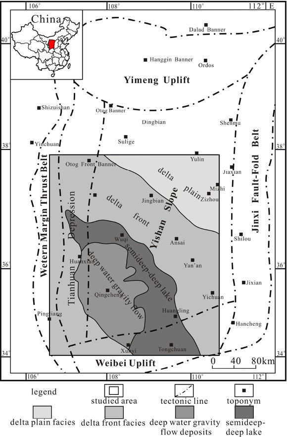
Tectonic map and sedimentary facies in the study area.
The oil - bearing Chang 7 Section is divided into Chang 73, Chang 72, and Chang 71 from bottom to top. Chang 73 represents the longest lacustrine transgression period in the Mesozoic in the basin. The deep lake area is vast and is represented by high - quality dark mudstones and black organic - rich shale. In Chang 72 sedimentary period, the lake area had gradually decreased. The delta sand deposits in the northeastern and southwestern regions advanced to the semi - deep and deep lake areas. Amounts of sediments from the southwest and south deposits on delta front and shallow lacustrine, and gravity flow deposits developed in the distal of the delta front and semi - deep lake areas. In Chang 71, the subsidence of the lake basin appears to have slowed, the lake basin area has contracted, the deposition exceeded the sedimentation rate, and the deposition of delta front deposits owing to high - energy traction currents increased. During this period, delta front sand deposits and gravity flow deposits from different sources accumulated in the center of the lake basin, producing fine - grained sheet - like sand bodies with wide distribution. These fine - grained clastic rocks fully covered the high organic shale, forming a unique "broad sedimentation" configuration combination of source and reservoir in the Mesozoic.
3 Lithologic features of the fine - grained sediments
The term fine - grained sedimentary rock refers to the content of grain whose diameter less than 0.0625 mm is more than 50%, and is mainly composed of clay, siltstone, and small amounts of endogenic carbonates, biological silica minerals, phosphates [39, 40].
Fine - grained sedimentary rocks is too fine to identify the mineral content by thin sections only. XRD can yield the mineral composition of samples based on the characteristic diffraction peaks of different minerals and the relationship between the mineral content and the intensity of its diffraction peaks. Thus we combine thin sections and XRD to identify the minerals and mineral content of fine - grained sedimentary rocks in the study area. The thin sections were analyzed at the Key Laboratory of Oil & Gas Resources and Exploration Technologies, Ministry of Education (Yangtze University), using a Carl Zeiss petrographic microscope (AxioScope.A1) with an ICCS optical system and magnification of 40 × to 1000 ×. The XRD data were collected at the Materials and Chemical Analysis and Testing Center in China University of Geosciences (Wuhan). A D8-FOCUS diffractometer with CuKα radiation and Ni filter was used with the experimental conditions of 40 kV and 40 mA, along with a LynxEye192 bit array detector with a 2θ scanning step of 0.01∘, 2θ range of 5 – 60∘, scanning speed 0.05 s/ step, and λ = 1.540598 A.
The fine - grained sediments of oil - bearing Chang 7 comprise mudstone, shale, siltstone, a small amount of carbonates and intermediate types of rock, which mainly deposit in delta front, semi - deep, and deep lacustrine deposits. Based on 141 XRD patterns from Chang 7, the mineral content was observed as follows: quartz 31.7%, feldspar 38.1%, clay minerals 24.2%, calcite and dolomite 4.0%, laumontite and clinoptilolite 0.8%, and pyrite 1.2%. Despite the differences in the minerals from the different sedimentary environments, the intermediate rocks are dominated by quartz and feldspar.
4 Lithologic identification of fine - grained sediments
4.1 Identification principles
The mineral composition and content of different fine - grained sedimentary rocks vary. Different minerals have different resistivities (RT), natural gamma rays (GR), acoustic (AC) velocities, densities (DEN), and neutron (CNL) absorption characteristics. Therefore, the logging responses of shale, sandstone, and carbonates vary regularly at the macroscale level (Table 3).
Logging responses vs lithology
| Lithology | GR (API) | DEN(g/cm3) | Δt (μs.m−1) | ρ (g.cm−3) | ΦN (%) |
|---|---|---|---|---|---|
| Shale | > 110 | 2.20 – 2.55 | > 300 | 2.10 – 2.50 | 30 – 40 |
| Sandstone | 40 – 110 | 2.40 – 2.60 | 180 – 250 | 2.30 – 2.65 | 10 – 23 |
| Limestone | 20 – 60 | 2.70 – 2.90 | 165 – 250 | 2.40 – 2.70 | 0 – 3 |
| Dolomite | 60 – 90 | 2.68 – 2.85 | 155 – 250 | 2.50 – 2.85 | 2 – 21 |
RT and GR are common in lithologic identification applications, and have achieved good application. AC, DEN and CNL are commonly used to calculate the porosity of coarse grained sandstone, their logging responses reflect the integrated information of the lithology, petrophysical properties and fluid properties. When one kind of information is weakened or reduced, the others will be highlighted. Due to the small porosity of fine - grained sedimentary rocks, siltstone is generally less than 10% and the porosity of shale is generally less than 6%, so the response of AC, DEN and CNL to physical properties is relatively weak. The logging response characteristics of the oil and gas section are characterized by increase of AC, reduction of DEN, and increase of CNL. The obvious hydrocarbon - bearing reservoir has correspondingly obvious responses, therefore, it is not necessary to suppress oil and gas information reflected by the AC, DEN and CNL methods at present. On the contrary, if the series of logging reactions are insensitive, it can not reflect the oil - bearing property of the section, resistivity or nuclear magnetic resonance and geologic logging data can be used jointly to find out the influence of oil and gas on AC, DEN and CNL, and combined with the lithology information of weak hydrocarbon - bearing zone, the lithology can be analyzed from multi - well correlation. Therefore, AC, DEN and CNL can also be used for lithologic identification of fine-grained sedimentary rocks (Figure 2).
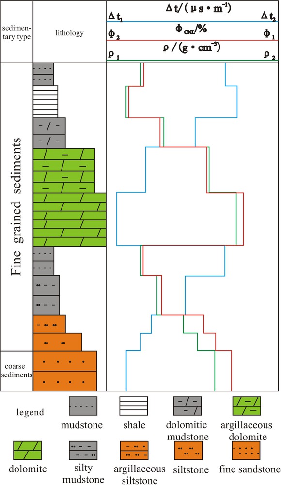
Typical logging data vs lithology.
4.2 Identification method
The following steps are used to identify the lithology of the fine - grained sediments in the study area.
First, core logging is performed at each coring well to ensure one - to - one correspondence of data. Second, Under the constraints of thin section identification and the measured data of XRD, a rock - electricity response chart of varies logging data and lithologies is set up by using logging curve cross plotting. Then a large number of data analysis and verification are used to observe its significance, and select the logging parameter variables with significant level. By using logging curve cross plotting of DEN and GR to preliminary identify the main types of fine - grained sedimentary rocks in different depositional system environments. Third, we perform multiple linear regression of mineral content and logging data versus well depth to observe the significance of the regression and coefficient, to eliminate the insignificant variables, and to fit the relation between the mineral content and the well measured value, i.e., the calculated mineral content. Fourth, we estimate the main minerals of the fine - grained sedimentary rocks and compare the calculated mineral content to that derived from the XRD patterns. If the test results are highly accurate, the recognition method can be used to explain the sedimentary lithology of fine - grained sediments in the oil - bearing Chang 7 Section.
(1) Preliminary calibration of fine - grained sedimentary rocks
The oil - bearing Chang 7 Section mainly comprises fine - grained sedimentary rocks such as siltstone, dark mudstone and black shale, and fine sandstone. First, on the basis of fine observation and description of cores, the logging is homing of each coring well. Based on thin section and XRD data, the rock - electricity response chart of varies logging data and lithologies is set up. A large number of data analysis and verification have been made, and we find that the changes of GR and DEN have a good correlation with the changes of lithology. Subsequently, GR and DEN are selected to predict the fine sedimentary rock types in the study area. The logging curve crossplot method (Figure 3) is established for the fine-grained sedimentary rocks of different sedimentary facies with the braided river delta, meandering river delta, and the semi - deep - to - deep lake deposit. The semi - deep - to - deep lake sedimentary sand body is mainly caused by the gravity flow. Therefore, the conventional GR and DEN logging curve parameters can be used to preliminarily calibrate the types of fine - grained sedimentary rocks.
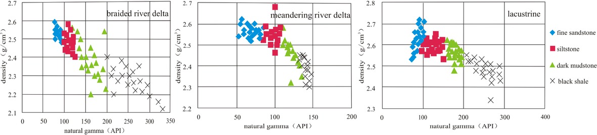
Correlations of logging parameters in the Chang 7 fine - grained sediments.
By statistic the GR and DEN values of fine-grain sedimentary rocks in different sedimentary environments, we find that in different sedimentary environments even the same type of fine-grained sedimentary rocks have different GR and DEN value, as shown in Table 4.
Logging parameters vs lithology in the Chang 7 oil - bearing Section
| Parameter | Braided river delta | Meandering river delta | Semi – deep – deep lacustrine deposits (including gravity flows) | |||||||||
|---|---|---|---|---|---|---|---|---|---|---|---|---|
| fine sandstone | siltstone | dark mudstone | black shale | fine sandstone | siltstone | dark mudstone | black shale | fine sandstone | siltstone | dark mudstone | black shale | |
| GR (API) | < 95 | 95 – 125 | 125 – 200 | > 200 | < 80 | 80 – 110 | 110 – 140 | > 200 | < 100 | 110 – 150 | 150 – 200 | > 200 |
| DEN (g/cm3) | 2.48 – 2.6 | 2.4 – 2.6 | 2.2 – 2.5 | 2.1 – 2.4 | 2.5 – 2.6 | 2.45 – 2.6 | 2.4 – 2.52 | 2.3 – 2.43 | 2.5– 2.6 | 2.45 – 2.55 | 2.45 – 2.55 | 2.33 – 2.45 |
(2) Calibration of mineral content
Using the logging curve crossplot, the main finegrained sedimentary rocks in the study area can be preliminarily calibrated to identify different rocks in sedimentary system environment; however, the main mineral content of the fine-grained sedimentary rocks cannot be predicted. Further, it is very hard to determine the mineral content of the all core by via XRD, and the core in one well is limited. In order to understand the distribution of main mineral content in the entire well section, we use point - segment modeling method to obtain the various conventional logging value in the depth that XRD samples corresponded. It means the conventional logging parameters value is the average value 10cm up and down at the depth the XRD samples corresponded, which effectively avoids the relative error caused by the depth homing deviation of cores. We use the conventional logging data as a variable and the SPSS software to perform multiple linear regression analysis on the measured data of the mineral content to observe the significance of the regression equation and coefficient and to eliminate the parameter variables that fail to reach the corresponding significant level. Further, the calculation formula of the main mineral content is fitted to obtain the distribution curves of major mineral contents in the whole well section. Next,we derive the relation between mineral and total organic carbon content and RT, GR, AC, DEN, and CNL in the oil - bearing Chang 7 Section (Table 5). The deviations between predicted and observed mineral content are shown in Figure 4.
Model equations for mineral content vs depth in Chang 7
| Model equation | correlation coefficient |
|---|---|
| ωquartz= 156.363 + 0.587 × log (RT) - 0.201 × GR × 38.994 × AC | 0.72 |
| ωfeldspar= 88.765 + 0.088 × log (RT) - 0.379 × CNL-27.004 × DEN | 0.64 |
| ωchlorite= - 32.514 + 0.958 × CNL + 0.02 × log (RT) + 19.205 × DEN - 0.04 × GR × 0.102 × AC | 0.65 |
| ωillite= - 574.448 - 3.363 × CNL - 0.391 × log (RT)+ 165.95 × DEN + 0.232 × GR+ 0.916 × AC | 0.73 |
| ωcalcite= - 3.76 - 0.024 × CNL + 1.797 × log (RT) - 0.04 × GR - 1.942 × DEN | 0.74 |
| ωdolomite= - 162.176 + 55.698 × DEN - 0.013 × GR + 0.1 × AC | 0.59 |
| ωTOC = 56.44 - 0.049 × AC - 17.05 × DEN + 0.037 × GR | 0.98 |
| ωpyrite= - 889.29 + 8.993 × CNL - 0.369 × log (RT) - 271.551 × DEN - 0.445 × GR - 1.111 × AC | 0.96 |
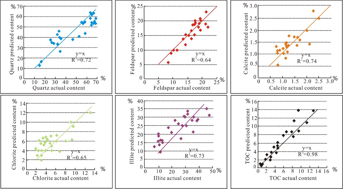
Predicted vs measured mineral content in Chang 7.
(3) Nomenclature of fine - grained sedimentary rocks
Based on the above methods, lithologic identification was performed on the fine - grained sediments of oil - bearing Chang 7 Section. To accurately predict the various conventional logging curves of fine sedimentary rocks corresponding to the depth of the well, the primary fine - grained sedimentary rocks in the study area are preliminarily calibrated using DEN and GR logging data. Then, using the prediction formula of the main minerals, mineral content in the fine - grained sedimentary rocks was calculated. Subsequently, the fine - grained sedimentary rocks are named by color, single - layer thickness, texture and structure, organic matter content and mineral composition. Through large analysis, the fine - grained sedimentary rocks mainly developed in the Chang 7 oil - bearing formation show in Table 6.
Fine-grained sedimentary rocks in Chang 7
| Rock types | Color | Single - layer thickness | Structure | Rock types | Mineral content | Distribution |
|---|---|---|---|---|---|---|
| ripple bedding, | ||||||
| light | medium- | horizontal bedding, | ||||
| lithic feldspar | ωfeldspar>50%; 25% < | |||||
| grayish | thin-bedded, | deformation | Good | |||
| siltstone | ωdebris< 50%; ωquartz<25% | |||||
| Siltstone | green, gray | massive | bedding, graded | |||
| bedding | ||||||
| light | medium- thin - | ripple bedding, | feldspathic debris | ωdebris> 50%; 25% < | ||
| grayish green, gray | bedded, massive | horizontal bedding, deformed bedding | siltstone | ωfeldspar< 50%; ωquartz< 25% | Good | |
| dark gray, gray black | thin - thick-bedded | graded bedding | feldspar siltstone | ωfeldspar> 75%; ωdebris< 25%; ωquartz< 25% | High | |
| dark gray, | feldspar lithic quartz | 50% < ωquartz<75%; ωdebris< | ||||
| gray black | thin - thick-bedded | graded bedding | siltstone | 25%;ωfeldspar< 25% | High | |
| gray, gray | horizontal bedding | organic-poor illite | ωillite>75%; ωchlorite<25%; | |||
| light mudstone | green | massive | mudstone | TOC < 2% | Moderate | |
| gray, gray | organic-poor chlorite | ωchlorite> 75%; ωillite< 25%; | ||||
| green | massive | horizontal bedding | mudstone | TOC < 2% | Moderate | |
| dark gray, | horizontal bedding, | organic-rich illite | ωillite> 75%; ωchlorite< 25%; | |||
| dark mudstone | gray black | thin - thick-bedded | graded bedding | mudstone | 2% < TOC < 4% | High |
| dark gray, | horizontal bedding, | organic-rich | ωchlorite> 75%; ωillite< | |||
| thin - thick-bedded | High | |||||
| gray black | graded bedding | chlorite mudstone | 25%;2% < TOC < 4% | |||
| microlaminae, | ||||||
| gray black, | straightlaminae, | organic - rich illite | ωillite> 75%; ωchlorite< 25%; | |||
| thick - bedded | Moderate | |||||
| black shale | black | intermit- | shale | TOC > 4% | ||
| tentlaminae | ||||||
| microlaminae, | ||||||
| gray black, | straightlaminae, | organic-rich | ωchlorite> 75%; ωillite< 25%; | |||
| black | thick - bedded | intermit- | chlorite shale | TOC > 4% | Moderate | |
| tentlaminae | ||||||
| dust color, | Less | |||||
| limestone | lenticular | — | limestone | ωcalcite> 75%; ωdolomite< 25% | ||
| gray | better | |||||
4.3 Discussion
The C96 well in Chang 7 yielded high - quality logging and XRD data and was thus selected to discuss the vertical distribution of the lithologies; the data was also verified by combining core and thin sections. We performed statistical analysis of the mineral and organic matter data using the SPSS software (Table 5); the main mineral content and the organic carbon prediction formula were fitted to the 22 data points in well C96. Then, we compared the deviation between predicted and measured data. The relative deviation (RD) for quartz is 9.460%, for feldspar is 8.820%, for illite is 10.038%, for chlorite is 9.959%, and TOC is 10.719% (Table 7), indicating that the prediction model (Table 5) yielded accurate results. Therefore, the SPSS software can be used to fit the main mineral content and the organic carbon prediction formula method to identify the lithologies of fine - grained sedimentary rocks and further explore the distribution characteristics of fine - grained sedimentary rocks.
Actual vs measured mineral content in the C96 well
| Serial number Depth(m) | Quartz(%) | Feldspar (%) | Illite (%) | Chlorite (%) | TOC (%) | |||||||||||
|---|---|---|---|---|---|---|---|---|---|---|---|---|---|---|---|---|
| measured | predicted | RD | measured | predicted | RD | measured | predicted | RD | measured value | predicted value | deviation rate | measured value | predicted value | RD | ||
| 1 | 1964.82 | 28.75 | 34.50 | 19.99 | 18.72 | 15.92 | 14.96 | 52.45 | 38.68 | 26.26 | 9.44 | 9.02 | 4.36 | 0.64 | 0.62 | 3.13 |
| 2 | 1965.59 | 46.28 | 38.33 | 17.17 | 19.42 | 17.04 | 12.27 | 28.89 | 29.62 | 2.53 | 9.14 | 9.52 | 4.15 | |||
| 3 | 1970.56 | 56.85 | 55.36 | 2.61 | 17.88 | 18.45 | 3.15 | 14.50 | 17.41 | 20.03 | 4.13 | 4.15 | 0.33 | 0.84 | 0.93 | 10.71 |
| 4 | 1973.27 | 63.29 | 62.77 | 0.82 | 17.78 | 19.62 | 10.37 | 12.00 | 15.01 | 25.12 | 4.82 | 3.76 | 22.01 | 4.08 | 4.12 | 0.98 |
| 5 | 1979.58 | 43.35 | 46.09 | 6.33 | 14.11 | 15.80 | 11.98 | 35.02 | 35.87 | 2.41 | 12.96 | 10.06 | 22.36 | 3.48 | 3.3 | 5.17 |
| 6 | 1981 | 35.45 | 36.36 | 2.57 | 10.44 | 10.65 | 2 | 32.60 | 32.51 | 0.28 | 4.74 | 5.54 | 16.87 | 6.2 | 5.76 | 7.10 |
| 7 | 1982.53 | 35.29 | 39.22 | 11.12 | 6.69 | 6.40 | 4.32 | 46.25 | 35.27 | 23.74 | 9.30 | 9.15 | 1.58 | 2.15 | 2.51 | 16.74 |
| 8 | 1989.25 | 64.42 | 53.40 | 17.12 | 18.62 | 17.97 | 3.5 | 9.81 | 23.11 | 1.28 | 4.82 | 5.22 | 8.20 | |||
| 9 | 1991.15 | 33.76 | 40.12 | 18.84 | 11.99 | 10.32 | 13.93 | 39.48 | 33.97 | 13.97 | 5.15 | 5.55 | 7.75 | 0.91 | 1.12 | 23.08 |
| 10 | 1993.42 | 65.86 | 52.71 | 19.97 | 20.81 | 18.76 | 9.83 | 19.32 | 15.91 | 17.62 | 5.34 | 5.95 | 11.45 | |||
| 11 | 1997.39 | 41.87 | 43.09 | 2.92 | 15.92 | 16.81 | 5.62 | 38.79 | 33.37 | 13.97 | 5.87 | 5.78 | 1.55 | 0.64 | 0.75 | 17.19 |
| 12 | 1998.64 | 63.37 | 63.60 | 0.36 | 19.00 | 20.33 | 6.97 | 11.83 | 2.56 | 6.11 | 3.50 | 3.70 | 5.65 | |||
| 13 | 2003.25 | 58.28 | 52.65 | 9.65 | 16.87 | 18.34 | 8.73 | 10.43 | 18.97 | 2.91 | 6.16 | 6.48 | 5.15 | |||
| 14 | 2006.6 | 66.51 | 62.42 | 6.14 | 21.15 | 19.61 | 7.32 | 7.61 | 8.58 | 12.70 | 3.51 | 3.55 | 1.05 | |||
| 15 | 2008.9 | 57.98 | 53.90 | 7.04 | 18.18 | 18.46 | 1.49 | 18.66 | 19.65 | 5.29 | 4.14 | 3.88 | 6.11 | |||
| 16 | 2013.02 | 67.05 | 54.68 | 18.45 | 17.51 | 18.11 | 3.45 | 17.15 | 21.04 | 22.68 | 4.25 | 3.95 | 7.14 | |||
| 17 | 2024.24 | 64.69 | 60.92 | 5.83 | 16.10 | 19.52 | 21.2 | 13.40 | 13.11 | 2.16 | 4.64 | 3.63 | 21.77 | |||
| 18 | 2028.99 | 62.89 | 57.49 | 8.6 | 19.18 | 19.21 | 0.16 | 13.06 | 14.30 | 9.51 | 3.73 | 4.08 | 9.33 | |||
| 19 | 2034.95 | 56.35 | 52.65 | 6.57 | 18.91 | 17.59 | 7.03 | 27.70 | 28.11 | 1.49 | 6.15 | 5.34 | 13.26 | |||
| 20 | 2043.05 | 35.56 | 37.50 | 5.46 | 23.34 | 16.38 | 22.82 | 36.05 | 37.65 | 4.43 | 4.92 | 6.27 | 27.37 | 3.44 | 3.72 | 8.14 |
| 21 | 2047.2 | 36.59 | 35.38 | 3.3 | 12.89 | 14.90 | 15.57 | 46.49 | 46.87 | 0.83 | 4.88 | 4.57 | 6.37 | 2 | 2.42 | 21.00 |
| 22 | 2058.43 | 14.97 | 12.39 | 17.26 | 13.30 | 14.28 | 7.36 | 54.51 | 57.51 | 5.51 | 1.89 | 1.60 | 15.29 | 12 | 11.44 | 4.67 |
| Average | 9.460 | 8.820 | 10.038 | 9.959 | 10.719 | |||||||||||
5 Vertical distribution characteristics of fine-grained sedimentary rocks
The C96 well is in the center of the lake basin. The sedimentary facies are semi – deep - to - deep lacustrine and channel - type gravity flow deposits. We apply the proposed identification method to the entire oil - bearing Chang 7 Section (118 m) in well C96. The identification results shown in Figure 5 suggest that the oil - bearing Chang 7 Section in the C96 well comprises six main types of fine - grained rock, including mud- debris feldspar lithic quartz fine - grained sandstone, massive feldspar lithic quartz fine sandstone, graded bedded feldspar lithic quartz siltstone, black organic - and illite-rich mudstone, dark organic - and illite-rich shale and banded tuff. The Chang 73 layer contains dark organic - and illite - rich shale and graded bedded feldspar lithic quartz siltstone that make up 44% and 43% of the total thickness of the layer and locally change into mud - debris feldspar lithic quartz fine - grained sandstone. Chang 72 contains massive feldspar lithic quartz fine sandstone, graded bedded feldspar lithic quartz siltstone, and dark organic - and illite- rich mudstone that account for 47%, 24%, and 13% of the total thickness of the layer and locally contain interbedded thin layers of organic - rich illite shale. Chang 71 contains dark organic - and illite - rich mudstone, graded bedded feldspar lithic quartz siltstone, and black organic - and illite - rich shale that account for 29%, 25%, and 21% of the total thickness of Chang 71 (Table 8).
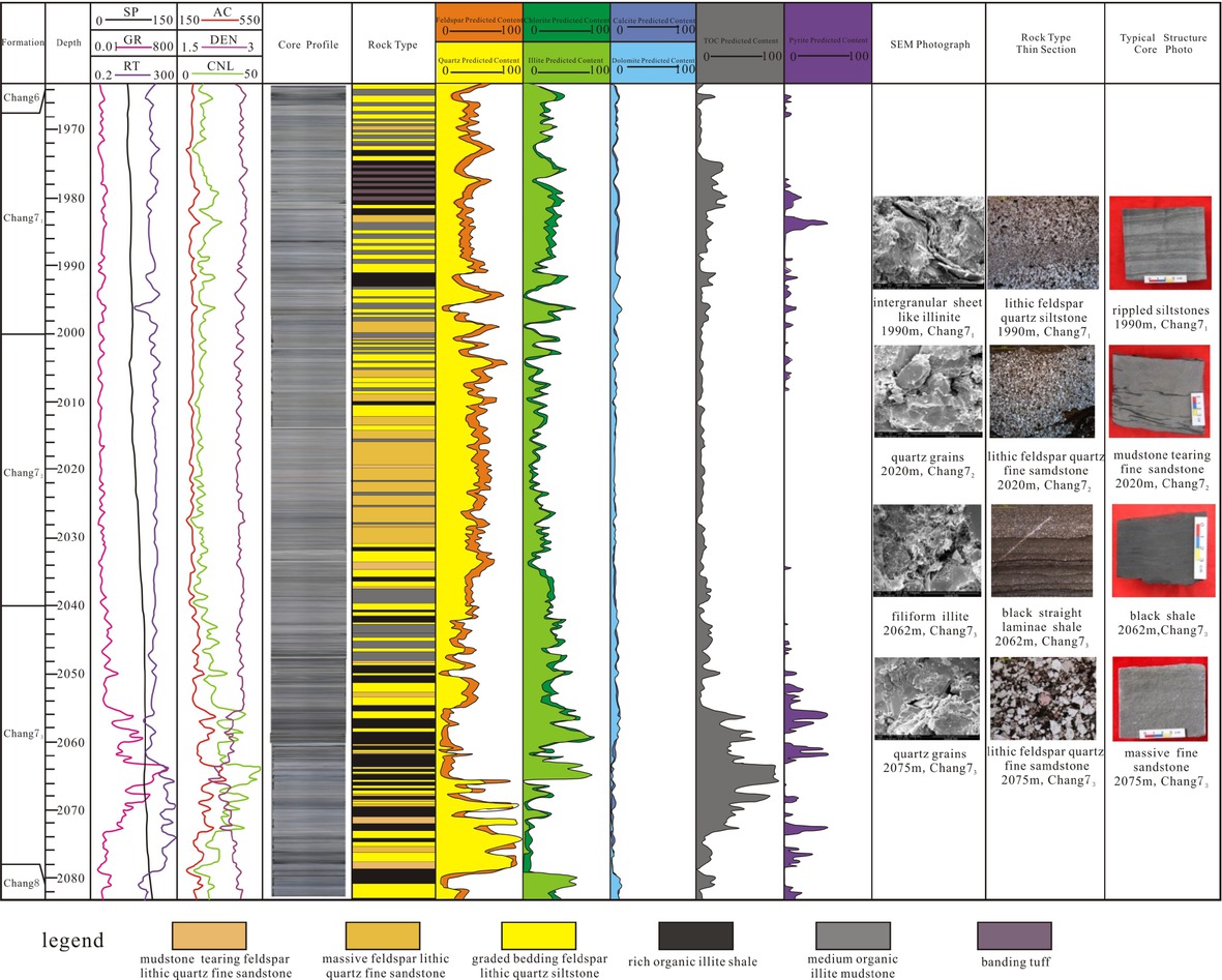
Histogram of the mineral content of the C96 well in Chang 7.
Rock types in the C96 well
| Massive | Graded | |||||
|---|---|---|---|---|---|---|
| Formation | Mud - debris feldspar lithic quartz fine sandstone | feldspar lithic quartz fine - grained | bedded feldspar lithic quartz | Organic- and illite - rich mudstone | Organic-and illite - rich shale | Banded tuff |
| sandstone | siltstone | |||||
| Chang 71 | 10% | 9% | 21% | 29% | 25% | 6% |
| Chang 72 | 7% | 47% | 24% | 13% | 9% | 0% |
| Chang 73 | 2% | 11% | 43% | 0% | 44% | 0% |
| Chang 7 | 6% | 23% | 29% | 14% | 26% | 2% |
6 Conclusions
Logging curve intersection and multivariate linear regression analysis are commonly used in logging lithologic identification. In this paper, the main fine - grained sedimentary rocks in the study area are preliminarily calibrated by using DEN and GR logging curves crossplot. Then the SPSS software is used to analyze the logging value and the measured mineral content by multiple linear regression analysis, the prediction model of organic carbon and the main mineral content is fitted. Based on the results, a comprehensive designation was made using the rock color, single - layer thickness, texture and structure, mineral composition, and organic matter content of the rock, i.e., “color + single-layer thickness + structure + (organic matter content) mineral composition.” The proposed method can be used for the quantitative analysis of main minerals of fine-grained sedimentary rocks; the method also improves the accuracy and universality of the identification of fine - grained sedimentary rocks using conventional logging data. The proposed methodology yields reliable results and may have wider applicability to fine - grained sedimentary rocks globally.
Acknowledgement
We are grateful to the anonymous reviewers for constructive comments as well as the editors. This research was financially supported by the Sci ence and Technology Research Project of Hubei Provincial Department of Education of China (No. Q20181308), the National Natural Science Foundation of China (No. 41672099), and the National Key Basic Research Program of China "973" (No. 2014CB239003).
References
[1] Curtis J.B., Fractured shale-gas systems. AAPG Bulletin, 2002, 86(11): 1921-1938.Search in Google Scholar
[2] Sageman B.B., Murphy A.E., Werne J.P., Straeten C.A.V., Hollander D.J., Lyons T.W., A tale of shales: the relative roles of production, decomposition, and dilution in the accumulation of organic-rich strata, Middle-Upper Devonian, Appalachian basin. Chemical Geology, 2003,195(1): 229-273.10.1016/S0009-2541(02)00397-2Search in Google Scholar
[3] Bowker K.A., Barnett Shale gas production, Fort Worth Basin: issues and discussion. AAPG Bulletin, 2007, 91(4) : 523-533.10.1306/06190606018Search in Google Scholar
[4] Yang Z.H., Li Z.M., Wang G.S., Teng G.E., Shen B.J., Enlightenment from petrology character, depositional environment and depositional model of typical shale gas reservoirs in North America. Geological Science and Technology Information, 2010, 29(6): 59-65 (in Chinese with English abstract).Search in Google Scholar
[5] Zhang L.Y., Li J.Y., Li Z., Zhang J.G., Zhu R.F., Bao Y.S., Advances in shale oil/gas research in North America and considerations on exploration for continental shale oil/gas in China. Advances in Earth Science, 2014, 29(6): 700-711 (in Chinese with English abstract).Search in Google Scholar
[6] Zhao J.L., Zhang J.F., Xu H., Yu T.X., Zhao D., Geng Y.G., Comparison of geological characteristics and types of typical tight oil in North America. Natural Gas Geoscience, 2015, 27(1): 44-50(in Chinese with English abstract).Search in Google Scholar
[7] Xie Z.K., Research on the Quaternary fine-fraction lithofacies and sedimentation model in Tainan Area, Qaidam Basin. Earth Science Frontiers, 2009, 16(5): 245-250(in Chinese with English abstract).10.1016/S1872-5791(08)60103-7Search in Google Scholar
[8] Liang C., Jiang Z.X., Yang Y.T., Wei X.J., Characteristics of shale lithofacies and reservoir space of the Wufeng–Longmaxi Formation, Sichuan Basin. Petroleum Exploration and Development, 2012, 39(6): 691-698 (in Chinese with English abstract).10.1016/S1876-3804(12)60098-6Search in Google Scholar
[9] Wang Z.F., Zhang Y.F., Liang X.L., Chen F., Jin Q.H., LiuW., Zhang H.B., Li H.P., Characteristics of shale lithofacies formed under different hydrodynamic conditions in the Wufeng-Longmaxi Formation, Sichuan Basin. Acta Petrolei Sinica, 2014, 35(4): 623-632 (in Chinese with English abstract).Search in Google Scholar
[10] Zhang S., Chen S.Y., Tan M.Y., Zhang Y.Y., Sun B.B., Gong W.L., Hu Z.Y., Hou Z.S., Characterization of sedimentary microfacies of shale in the lower third sub-member of Shahejie Formation, western Dongying sag. Acta Petrolei Sinica, 2014, 35(4): 633-645 (in Chinese with English abstract).Search in Google Scholar
[11] Liu B., Lü Y.F., Meng Y.L., Li X.N. Guo X.B., Ma Q., Zhao W.C., Petrologic characteristics and genetic model of lacustrine lamellar fine-grained rock and its significance for shale oil exploration: A case study of Permian Lucaogou Formation in Malang sag, Santanghu Basin, NW China. Petroleum Exploration and Development, 2015, 42(5): 598-607 (in Chinese with English abstract).10.1016/S1876-3804(15)30060-4Search in Google Scholar
[12] Zhao X.S., Guo F., Shi L.H., Dang H.L., Lacustrine Fine Grain Deposition and Its Significance to Shale Gas——A Case Study of Chang 7 Reservoir in Yanchang Formation, Liuluoyu Block, Xiasiwan Area. 2015, 2(5): 1-6(in Chinese with English abstract).Search in Google Scholar
[13] Pu X.G., HanW.Z., Zhou L.H., Chen S.Y., ZhangW., Shi Z.N., Yang F., Liu S., Lithologic characteristics and geological implication of fine-grained sedimentation in Ek2 high stand system tract of Cangdong Sag, Huanghua Depression. China Petroleum Exploration, 2015, 20(5): 30-40 (in Chinese with English abstract).Search in Google Scholar
[14] Yuan X.J., Lin S.H., Liu Q., Yao J.L., Wang L., Guo H., Deng X.Q., Cheng D.W., Lacustrine fine-grained sedimentary features and organic-rich shale distribution pattern: A case study of Chang 7 Member of Triassic Yanchang Formation in Ordos Basin, NW China. Petroleum Exploration and Development, 2015, 42(1): 34-43 (in Chinese with English abstract).10.1016/S1876-3804(15)60004-0Search in Google Scholar
[15] Chen B.T., Pan S.X., Wang T.Q., Zhang Q.S., Liang S.J. Liu C.Y., Sedimentary microfacies of deepwater fine-grained depositional system and its significance for shale oil and gas exploration in Qingshankou Formation, Qijia-Gulong depression, Songliao Basin, Northeast China. Journal of Central South University (Science and Technology), 2015, 46(9): 3338-3345 (in Chinese with English abstract).Search in Google Scholar
[16] Wu J., Jiang Z.X., Pan Y.W., Zhang Q., He L.Q., Lacustrine finegrained depositional model: a case study of the upper submember of the fourth Member of Paleogene Shahejie Formation in Dongying sag. Acta Petrolei Sinica, 2016, 37(9): 1080-1089 (in Chinese with English abstract).Search in Google Scholar
[17] Zhang S.M., Cao Y.C., Zhu R.K., Wang W., Tu J.Q., Mao Z.G. Bai B., The lithofacies and depositional environment of fine-grained sedimentary rocks of Xiaohu Subsag in Yabulai Basin. Natural Gas Geoscience, 2016, 27(2): 309-319 (in Chinese with English abstract).Search in Google Scholar
[18] Wang Y.M., Dong D.Z., Yang Hua, He L., Wang S.Q., Huang J.L., Pu B.L.,Wang S.F., Quantitative characterization of reservoir space in the Lower Silurian Longmaxi Shale, southern Sichuan, China. Science China: Earth Sciences, 2014, 44(6): 1348-1356 (in Chinese with English abstract).10.1007/s11430-013-4645-ySearch in Google Scholar
[19] Xu Z.X., Heterogeneity of shale reservoirs based on CT images. Lithologic Reservoirs, 2014, 26(6): 46-49 (in Chinese with English abstract).Search in Google Scholar
[20] YangW., Chen G.J., Hu S.J., Lü C.F., Xu Y., Yang S., Pore characteristics of shale of Lower Paleozoic in southern Sichuan- northern Guizhou. Lithologic Reservoirs, 2015, 27(4): 47-52 (in Chinese with English abstract).Search in Google Scholar
[21] Chen S.Y., Zhang S., Wang Y.S., Tan M.Y., Lithofacies types and reservoirs of Paleogene fine-grained sedimentary rocks in Dongying Sag, Bohai Bay Basin. Petroleum Exploration and Development, 2016, 43(2): 198-208(in Chinese with English abstract).10.1016/S1876-3804(16)30025-8Search in Google Scholar
[22] Kong X.X., Jiang Z.X., Han C., Zheng L.Q., Yang Y.P., Liu Y.P., Laminations characteristics and reservoir significance of finegrained carbonate in the lower 3rd member of Shahejie Formation of Shulu sag. Petroleum Geology and Recovery Eflciency, 2016, 23(4): 19-26 (in Chinese with English abstract).Search in Google Scholar
[23] Bai W.H., Wu Y.B., Gao Z.L., Sun S.S., Study on the Mechanism of Oil Shale Minerogenetic Enrichmen in the Arm of Shallow to Half-deep Lake Depositional Environment. Geological Surwey and Research, 2010, 33(3): 207-214 (in Chinese with English abstract).Search in Google Scholar
[24] Huang B.J., Huang H.T., Wu G.X., You J.J., Geochemical characteristics and formation mechanism of Eocene lacustrine organic-rich shales in the Beibuwan Basin. Acta Petrolei Sinica, 2012, 33(1): 25-31 (in Chinese with English abstract).Search in Google Scholar
[25] Wang L.L., Wang Z.Q., Li Q., Zhang R.C., Controlling Factors of Sandbody Distribution on the Fine-grained Sedimentary Area in Lacustrine Fault Basins. Science Technology and Engineering, 2016, 16(10): 17-22 (in Chinese with English abstract).Search in Google Scholar
[26] Pang J.G., Li S., Yang Y.Y., Liu L.J., Zhu J., Chen D., Study progress of origin of fine-grained sedimentary rocks in deep-water area of lacustrine basin: Taking Yangchang Formation in Ordos Basin as an example. Petroleum Geology & Experiment, 2014, 36(6): 706-711 (in Chinese with English abstract).Search in Google Scholar
[27] Wu K.L., Chen Z.X., Li J., Xu J.Z., Wang K., Wang S.H., Dong X.H., Zhu Z.Y., Peng Y., Jia X.F., Li X.F., Manipulating the Flow of Nanoconfined Water by Temperature Stimulation. Angewandte Chemie International Edition, 2018, 130(28), 8568–8573.10.1002/ange.201712915Search in Google Scholar
[28] Wu K.L., Chen Z.X., Li J., Li X.F., Xu J.Z., Dong X.H., Wettability effect on nanoconfined water flow. Proceedings of the National Academy of Sciences, 2017, 114(13), 3358–3363.10.1073/pnas.1612608114Search in Google Scholar PubMed PubMed Central
[29] Wu K.L., Chen Z.X., Li, X. F., Xu J.Z., Li J., Wang K., Wang S.H. Dong X. H., Flow behavior of gas confined in nanoporous shale at high pressure: Real gas effect. Fuel, 2017, 205, 173–183.10.1016/j.fuel.2017.05.055Search in Google Scholar
[30] Wu K.L., Li X.F., Guo C.H., Wang, C. C., & Chen, Z.X., A Unified Model for Gas Transfer in Nanopores of Shale-Gas Reservoirs: Coupling Pore Diffusion and Surface Diffusion. SPE Journal, 2016, 21(05), 1583–1611.10.2118/2014-1921039-PASearch in Google Scholar
[31] Fu G.M., Yan J.Y., Zhang K., Hu H., Luo F., Current status and progress of lithology identification technology. Progress in Geophysics(in Chinese), 2017, 32 (1) : 26-40.Search in Google Scholar
[32] Tian Y., Sun J.M.,Wang X., Tian G.D., Identifying reservoir lithology by step-by-step method and Fisher discriminant. Progress in Exploration Geophysics, 2010, 33(2): 126-130 (in Chinese with English abstract).Search in Google Scholar
[33] Zhong Y.H., Li R., Application of principal component analysis and least square support vector machine to lithology identification. Well Logging Technology, 2009, 33(5): 425-429(in Chinese with English abstract).Search in Google Scholar
[34] Yang H., Huang J.Q., Hu X.T., Shi M.Y., Application of BP neural net in lithologic identification of tight sandstone gas reservoirs. Petroleum Geophysics, 2013, 11(1): 39-42(in Chinese with English abstract).Search in Google Scholar
[35] Li Z.G., Wang Z.H., Liu H.J., The comparative study of the lithologic identification based on conventional well logging information. Chinese Journal of Engineering Geophysics, 2015, 12(1): 77-82.Search in Google Scholar
[36] Zhao J., Yang Y., Chen W.Z., Li J.F., New method for well logging lithologic identification based on elemental capture spectroscopy. Progress in Geophysics, 2015, 30(5): 2342-2348(in Chinese with English abstract).Search in Google Scholar
[37] Gong J.S., Yang M.Y., Wang J, Xu C., Application of ECS logging technology in unconventional reservoir evaluation. Reservoir Evaluation and Development, 2014, 4(2): 76-80(in Chinese with English abstract).Search in Google Scholar
[38] Deng X.Q., Fu J.H., Yao J.L., Pang J.L., Sun B., Sedimentary facies of the Middle - Upper Triassic Yanchang Formation in Ordos Basin and breakthrough in petroleum exploration. Journal of Palaeogeography, 2011, 13(4): 443-455 (in Chinese with English abstract).Search in Google Scholar
[39] Krumbein W.C., The dispersion of fine-grained sediments for mechanical analysis. Journal of Sedimentary Research, 1933, 3(3): 121-135.10.2110/jsr.3.121Search in Google Scholar
[40] Picard M.D., Classification of fine-grained sedimentary rocks. Journal of Sedimentary Research, 1971, 41(1): 179-195.Search in Google Scholar
© 2019 Qiqi Lyu et al., published by De Gruyter
This work is licensed under the Creative Commons Attribution 4.0 Public License.
Articles in the same Issue
- Regular Articles
- 2D Seismic Interpretation of the Meyal Area, Northern Potwar Deform Zone, Potwar Basin, Pakistan
- A new method of lithologic identification and distribution characteristics of fine - grained sediments: A case study in southwest of Ordos Basin, China
- Modified Gompertz sigmoidal model removing fine-ending of grain-size distribution
- Diagenesis and its influence on reservoir quality and oil-water relative permeability: A case study in the Yanchang Formation Chang 8 tight sandstone oil reservoir, Ordos Basin, China
- Evaluation of AHRS algorithms for Foot-Mounted Inertial-based Indoor Navigation Systems
- Identification and evaluation of land use vulnerability in a coal mining area under the coupled human-environment
- Hydrocarbon Generation Potential of Chia Gara Formation in Three Selected Wells, Northern Iraq
- Source Analysis of Silicon and Uranium in uranium-rich shale in the Xiuwu Basin, Southern China
- Lithologic heterogeneity of lacustrine shale and its geological significance for shale hydrocarbon-a case study of Zhangjiatan Shale
- Characterization of soil permeability in the former Lake Texcoco, Mexico
- Detrital zircon trace elements from the Mesozoic Jiyuan Basin, central China and its implication on tectonic transition of the Qinling Orogenic Belt
- Turkey OpenStreetMap Dataset - Spatial Analysis of Development and Growth Proxies
- Morphological Changes of the Lower Ping and Chao Phraya Rivers, North and Central Thailand: Flood and Coastal Equilibrium Analyses
- Landscape Transformations in Rapidly Developing Peri-urban Areas of Accra, Ghana: Results of 30 years
- Division of shale sequences and prediction of the favorable shale gas intervals: an example of the Lower Cambrian of Yangtze Region in Xiuwu Basin
- Fractal characteristics of nanopores in lacustrine shales of the Triassic Yanchang Formation, Ordos Basin, NW China
- Selected components of geological structures and numerical modelling of slope stability
- Spatial data quality and uncertainty publication patterns and trends by bibliometric analysis
- Application of microstructure classification for the assessment of the variability of geological-engineering and pore space properties in clay soils
- Shear failure modes and AE characteristics of sandstone and marble fractures
- Ice Age theory: a correspondence between Milutin Milanković and Vojislav Mišković
- Are Serbian tourists worried? The effect of psychological factors on tourists’ behavior based on the perceived risk
- Real-Time Map Matching: A New Algorithm Integrating Spatio-Temporal Proximity and Improved Weighted Circle
- Characteristics and hysteresis of saturated-unsaturated seepage of soil landslides in the Three Gorges Reservoir Area, China
- Petrographical and geophysical investigation of the Ecca Group between Fort Beaufort and Grahamstown, in the Eastern Cape Province, South Africa
- Ecological risk assessment of geohazards in Natural World Heritage Sites: an empirical analysis of Bogda, Tianshan
- Integrated Subsurface Temperature Modeling beneath Mt. Lawu and Mt. Muriah in The Northeast Java Basin, Indonesia
- Go social for your own safety! Review of social networks use on natural disasters – case studies from worldwide
- Forestry Aridity Index in Vojvodina, North Serbia
- Natural Disasters vs Hotel Industry Resilience: An Exploratory Study among Hotel Managers from Europe
- Using Monarch Butterfly Optimization to Solve the Emergency Vehicle Routing Problem with Relief Materials in Sudden Disasters
- Potential influence of meteorological variables on forest fire risk in Serbia during the period 2000-2017
- Controlling factors on the geochemistry of Al-Shuaiba and Al-Mejarma coastal lagoons, Red Sea, Saudi Arabia
- The Influence of Kaolinite - Illite toward mechanical properties of Claystone
- Two critical books in the history of loess investigation: ‘Charakteristik der Felsarten’ by Karl Caesar von Leonhard and ‘Principles of Geology’ by Charles Lyell
- The Mechanism and Control Technology of Strong Strata Behavior in Extra-Thick Coal Seam Mining Influenced by Overlying Coal Pillar
- Shared Aerial Drone Videos — Prospects and Problems for Volunteered Geographic Information Research
- Stable isotopes of C and H in methane fermentation of agriculture substrates at different temperature conditions
- Prediction of Compression and Swelling Index Parameters of Quaternary Sediments from Index Tests at Mersin District
- Detection of old scattered windthrow using low cost resources. The case of Storm Xynthia in the Vosges Mountains, 28 February 2010
- Remediation of Copper and Zinc from wastewater by modified clay in Asir region southwest of Saudi Arabia
- Sedimentary facies of Paleogene lacustrine dolomicrite and implications for petroleum reservoirs in the southern Qianjiang Depression, China
- Correlation between ore particle flow pattern and velocity field through multiple drawpoints under the influence of a flexible barrier
- Atmospheric refractivity estimation from AIS signal power using the quantum-behaved particle swarm optimization algorithm
- A geophysical and hydro physico-chemical study of the contaminant impact of a solid waste landfill (swl) in King Williams’ Town, Eastern Cape, South Africa
- Landscape characterization using photographs from crowdsourced platforms: content analysis of social media photographs
- A Study on Transient Electromagnetic Interpretation Method Based on the Seismic Wave Impedance Inversion Model
- Stratigraphy of Architectural Elements of a Buried Monogenetic Volcanic System
- Variable secondary porosity modeling of carbonate rocks based on μ-CT images
- Traditional versus modern settlement on torrential alluvial fans considering the danger of debris flows: a case study of the Upper Sava Valley (NW Slovenia)
- The Influence of Gangue Particle size and Gangue Feeding Rate on Safety and Service Life of the Suspended Buffer’s Spring
- Research on the Transition Section Length of the Mixed Workface Using Gangue Backfilling Method and Caving Method
- Rainfall erosivity and extreme precipitation in the Pannonian basin
- Structure of the Sediment and Crust in the Northeast North China Craton from Improved Sequential H-k Stacking Method
- Planning Activities Improvements Responding Local Interests Change through Participatory Approach
- GIS-based landslide susceptibility mapping using bivariate statistical methods in North-western Tunisia
- Uncertainty based multi-step seismic analysis for near-surface imaging
- Deformation monitoring and prediction for residential areas in the Panji mining area based on an InSAR time series analysis and the GM-SVR model
- Statistical and expert-based landslide susceptibility modeling on a national scale applied to North Macedonia
- Natural hazards and their impact on rural settlements in NE Romania – A cartographical approach
- Rock fracture initiation and propagation by mechanical and hydraulic impact
- Influence of Rapid Transit on Accessibility Pattern and Economic Linkage at Urban Agglomeration Scale in China
- Near Infrared Spectroscopic Study of Trioctahedral Chlorites and Its Remote Sensing Application
- Problems with collapsible soils: Particle types and inter-particle bonding
- Unification of data from various seismic catalogues to study seismic activity in the Carpathians Mountain arc
- Quality assessment of DEM derived from topographic maps for geomorphometric purposes
- Remote Sensing Monitoring of Soil Moisture in the Daliuta Coal Mine Based on SPOT 5/6 and Worldview-2
- Utilizing Maximum Entropy Spectral Analysis (MESA) to identify Milankovitch cycles in Lower Member of Miocene Zhujiang Formation in north slope of Baiyun Sag, Pearl River Mouth Basin, South China Sea
- Stability Analysis of a Slurry Trench in Cohesive-Frictional Soils
- Integrating Landsat 7 and 8 data to improve basalt formation classification: A case study at Buon Ma Thuot region, Central Highland, Vietnam
- Assessment of the hydrocarbon potentiality of the Late Jurassic formations of NW Iraq: A case study based on TOC and Rock-Eval pyrolysis in selected oil-wells
- Rare earth element geochemistry of sediments from the southern Okinawa Trough since 3 ka: Implications for river-sea processes and sediment source
- Effect of gas adsorption-induced pore radius and effective stress on shale gas permeability in slip flow: New Insights
- Development of the Narva-Jõesuu beach, mineral composition of beach deposits and destruction of the pier, southeastern coast of the Gulf of Finland
- Selecting fracturing interval for the exploitation of tight oil reservoirs from logs: a case study
- A comprehensive scheme for lithological mapping using Sentinel-2A and ASTER GDEM in weathered and vegetated coastal zone, Southern China
- Sedimentary model of K-Successions Sandstones in H21 Area of Huizhou Depression, Pearl River Mouth Basin, South China Sea
- A non-uniform dip slip formula to calculate the coseismic deformation: Case study of Tohoku Mw9.0 Earthquake
- Decision trees in environmental justice research — a case study on the floods of 2001 and 2010 in Hungary
- The Impacts of Climate Change on Maximum Daily Discharge in the Payab Jamash Watershed, Iran
- Mass tourism in protected areas – underestimated threat? Polish National Parks case study
- Decadal variations of total organic carbon production in the inner-shelf of the South China Sea and East China Sea
- Hydrogeothermal potentials of Rogozna mountain and possibility of their valorization
- Postglacial talus slope development imaged by the ERT method: comparison of slopes from SW Spitsbergen, Norway and Tatra Mountains, Poland
- Seismotectonics of Malatya Fault, Eastern Turkey
- Investigating of soil features and landslide risk in Western-Atakent (İstanbul) using resistivity, MASW, Microtremor and boreholes methods
- Assessment of Aquifer Vulnerability Using Integrated Geophysical Approach in Weathered Terrains of South China
- An integrated analysis of mineralogical and microstructural characteristics and petrophysical properties of carbonate rocks in the lower Indus Basin, Pakistan
- Applicability of Hydrological Models for Flash Flood Simulation in Small Catchments of Hilly Area in China
- Heterogeneity analysis of shale reservoir based on multi-stage pumping data