Diagenesis and its influence on reservoir quality and oil-water relative permeability: A case study in the Yanchang Formation Chang 8 tight sandstone oil reservoir, Ordos Basin, China
-
Meng Wang

Abstract
Different from conventional reservoirs, unconventional tight sand oil reservoirs are characterized by low or ultra-low porosity and permeability, small pore-throat size, complex pore structure and strong heterogeneity. For the continuous exploration and enhancement of oil recovery from tight oil, further analysis of the origins of the different reservoir qualities is required. The Upper Triassic Chang 8 sandstone of the Yanchang Formation from the Maling Oilfield is one of the major tight oil bearing reservoirs in the Ordos Basin. Practical exploration demonstrates that this formation is a typical tight sandstone reservoir. Samples taken from the oil layer were divided into 6 diagenetic facies based on porosity, permeability and the diagenesis characteristics identified through thin section and scanning electron microscopy. To compare pore structure and their seepage property, a high pressure mercury intrusion experiments (HPMI), nuclear magnetic resonance (NMR), andwater-oil relative permeability test were performed on the three main facies developed in reservoir. The reservoir quality and seepage property are largely controlled by diagenesis. Intense compaction leads to a dominant loss of porosity in all sandstones, while different degrees of intensity of carbonate cementation and dissolution promote the differentiation of reservoir quality. The complex pore structure formed after diagenesis determines the seepage characteristics, while cementation of chlorite and illite reduce the effective pore radius, limit fluid mobility, and lead to a serious reduction of reservoir permeability.
1 Introduction
Recently, due to the considerable resources available, unconventional tight sandstone reservoirs have gradually become the main target of oil and gas energy development [1]. However, poor physical properties, small throats, complex pore structures and strong heterogeneity of tight sandstone can bring a series of complex problems for oil and gas exploration and development [2, 3]. The detailed evaluation and description of the characteristics of reservoir quality, including porosity, permeability, movable fluid saturation, and oil-water relative permeability, can identify the origin of different reservoir qualities by analyzing diagenesis; these steps are the keys to predicting the dominant reservoirs and efficiently exploring and developing tight oil and gas. In the process of oil production by water injection, clearly understanding the characteristic of pore structure, fluid distribution and two-phase fluid dynamic migration is especially important as the basis for remaining oil studies and enhancing oil recovery [4, 5]. Reservoir quality is primarily controlled by the microscopic pore morphology and structural features. A large number of research studies were conducted pertaining to pore structure in tight sandstone reservoirs [6, 7, 8]. Thin sections, scanning electron microscope (SEM) high-pressure mercury injection (HPMI), nuclear magnetic resonance (NMR), X-ray computer tomography (XCT) and other qualitative or quantitative characterization techniques have been applied to describe and evaluate the pore structure [9, 10, 11, 12, 13].
The purpose of studying the influencing factors of reservoir quality is to better guide the exploration and exploitation of tight oil. Many studies have found that the same diagenetic facies usually have similar characteristics in their components, pores structure and diagenesis evolution [14]; when these characteristics were noticed, many practical studies were carried out on high quality reservoir prediction by correlating the diagenetic facies to well logs. Predictive models based on probabilistic neural networks (PNN) [15, 16] and an artificial neural network (ANN) were also effective [17, 18]. Two major problems need to be solved before quality prediction is possible; one is how to divide diagenetic facies according to reservoir composition, structure and diagenesis, and the other is to clarify the formation mechanism of reservoir quality corresponding to different diagenetic facies, to identify the diagenetic facies favorable for reservoir development.
The Chang 8 sandstone of the Yanchang Formation in the Maling Oilfield is the main crude oil production layer in the Ordos Basin with a large distribution of oil layers and low porosity, low permeability and strong heterogeneity [19]. Early studies have confirmed the influence of sedimentary facies distribution and diagenesis [20]. Although some scholars have discussed the origin of tight reservoirs [21], most research has been based on the general analysis of all types of samples, which is not conducive to clarifying the differences in reservoir quality and fluid seepage characteristics. Therefore, it is necessary to find an effective research method for evaluation of classification. The diagenetic facies is a direct reflection of the lithology and physical characteristics of the reservoir; hence, classification based on diagenesis can effectively classify the reservoir, which facilitates the detailed study of reservoir quality evaluation and seepage.
Based on the study of the petrological and pore structure characteristics, the Chang 8 reservoir was divided in six diagenetic facies. Comprehensive analysis of three diagenetic facies of reservoir was carried out based on the pore structure, movable fluid properties and two-phase seepage characteristics. The effects of diagenesis on reservoir quality and oil-water relative permeability are illustrated. The main purpose of this paper is to establish an effective reservoir classification method to conduct a targeted analysis on the diversity of reservoir quality and seepage mechanisms.
2 Geological background
The Maling Oilfield in the southwest of the Ordos Basin is the earliest developed oilfield in the basin. This oilfield is a reservoir bearing structural-lithologic traps and oil with a regional area of approximately 1000 km2 [19]. The structure is located in the southwest of the Yishan Slope, controlled by a western thrust belt. The Tianhuan depression, Yishan Slope and Weibei Uplift represent the four tectonic units, and the structure in the study area presents a unicline characterized by a westward low and eastward high and a low dip angle that is less than 1∘ (Figure 1A). A series of near east – west trending, low amplitude, small nose-like uplifts are developed locally; faults and folds are not developed and the tectonic conditions are stable [22, 23]. The Triassic-age Yanchang Formation is the main oil layer. The sedimentary period of the Yanchang Formation mainly consists of continental facies in a sedimentary depression lake basin (Figure 1B) [24, 25]. The formation can be divided into 10 oil layers from top to bottom (i.e., Chang 1-Chang 10 layer). The thickness of the Chang 8 Formation is generally 70-100 m (Figure 1C). The formation’s deposition source from its sedimentary period came from the northeast, northwest, west and southwest cardinal directions with typical shallow-water delta sedimentary characteristics (Figure 1C) [26, 27]; the main reservoir developed in a delta plain distributary channel and the delta’s underwater distributary channel and mouth bar, which has a thickness of approximately 10 to 20 m. The reservoir lithology is mainly gray silty sandstone and fine sandstone. The Chang 8 reservoir is a typical low porosity and low permeability reservoir [28]. However, with the deepening of development, relatively high porosity and permeability reservoir characteristics have been discovered under the entire tight sandstone background. These sweet spots formed a serious high quality reservoir, which is the focus of future exploration and development.
![Figure 1 (a) Location of structural units and the Maling Oilfield in the Ordos Basin. (b) Sandbody distribution and sampling well location (c) Lithologic section for the study area showing the location of the Chang 8 interval within the Yanchang Formation (modified after [26]).](/document/doi/10.1515/geo-2019-0004/asset/graphic/j_geo-2019-0004_fig_001.jpg)
(a) Location of structural units and the Maling Oilfield in the Ordos Basin. (b) Sandbody distribution and sampling well location (c) Lithologic section for the study area showing the location of the Chang 8 interval within the Yanchang Formation (modified after [26]).
3 Sample and method
In this study, approximately 100 core plugs were collected from 15 bore wells in the Maling Oilfield (Figure 1B). All of the sample parameters were analyzed at the State Key Laboratory of the Southwest Petroleum University.
Porosity and horizontal permeability tests were performed on all core plugs with a Low-Permeability Gas Measurement 700 unit made by Sanchez Technologies under a net of confining pressures of 5 MPa. In addition, some data were provided by the Institute for Geological Research of the Second Oil Extraction Factory of the Changqing Oilfield.
Each plug has been polished for thin section analysis and prepared by vacuum impregnation with red epoxy resin. Rock mineralogy, diagenetic features, pore characteristics and cements were analyzed using an LV 100PO polarized optical microscope.
Different diagenetic facies have been divided out based on the results obtained from the thin sections; 12 samples of three typical diagenetic facies in reservoir development were selected to perform scanning electron microscope on with a Quanta 450 ESEM, which is useful for the identification clays and pore characteristics.
High pressure mercury injection (HPMI), nuclear magnetic resonance (NMR) and oil-water relative permeability measurements were performed on the aforementioned 12 samples.
The HPMI measurements were conducted with a Quanta chrome Poremaster-60 Mercury Injection Apparatus and relevant parameters, such as capillary pressure curves, threshold pressure, the maximum pore radius, the medium pore throat radius, and the maximum mercury saturation were obtained.
NMR analysis was performed on the plug samples under 100% saturated and centrifuged conditions (2.07MPa). The NMR T2 distributions were measured at 25∘C using a MacroMR12-150H-I nuclear magnetic resonance instrument. The test parameters of the apparatus were set as a receiver delay (RD) of 500 ms, echo time (TE) of 3.5 ms and number of echoes of 400.
Oil-water relative permeability measurement was performed with aHAG-250 Permeability Tester; this analysis is important for quantitative characterization of oil and water two-phase flow.
4 Results and discussion
4.1 Diagenetic facies and pore structure
Grigsby and Langford (1996) first proposed the concept of diagenetic facies to describe diagenetic heterogeneity in sandstone reservoirs [29]. Zou redefined the concept based on extensive sandstone reservoir research in China; they thought diagenetic facies were the result of diagenetic and structural the processes interacting with sedimentary features [30]. Regardless of their definition, the diagenetic facies is a comprehensive reflection of diagenesis types and strength, diagenetic minerals, and other information [30, 31]. Therefore, it is widely used to illustrate the diagenetic history, evaluate reservoir quality, explain the genesis of tight sandstone and predict ’sweet spots’ in recent years [30, 32, 33, 34].
Generally, diagenetic facies are classified on the basis of such parameters as grain size, authigenic minerals, sorting, clay matrix content, and pore structure [34]. A large number of research publications focus on the classification of diagenetic facies [33, 35]. The tight sandstone in the Ordos Basin is one of these hot spots and some new achievements have been obtained through the study of the sandstone in Chang 3, Chang 7 and Chang 8, the major oil layer of Upper Triassic Yanchang formation [32, 36, 37].
According to the microscopic observation of the polished thin sections, the lithology of the reservoir rocks sandstone is dominated by lithic arkose and feldspathic litharenite followed by litharenite. Cements are dominated by clay and carbonate minerals. Based on lithological characteristics, such as the texture, composition, type and degree of diagenesis, diagenetic minerals, and pore structure characteristics, the Chang 8 sandstone has been divided into six diagenetic facies (Figure 2). Facies I: Weakly compacted and weakly cemented, high primary porosity facies (Figure 2a).

Microscopic characteristics and porosity/permeability parameters of each diagenetic facies. (a) H-54, 2807.52 m; (b) H-81, 2484.42 m; (c) H-69, 2347.06 m; (d) L-63, 2180.11 m; (e) L-63, 2180.11 m; (f) L-53, 2117.26 m. (g) Correlation between porosity and permeability of different diagenetic facies type; (h) distribution of average porosity and permeability of different diagenetic facies type.
This facies is characterized by weak compaction, low cement minerals, and low matrix content. Primary intergranular pores have been well-preserved, and there are certain feldspar and lithic dissolution pores. The sandstone is porosity-cemented and the intergranular contact is mainly a point contact. Facies II: Weakly compacted and intensely chlorite cemented, high primary porosity facies (Figure 2b).
Chlorite cementation is intensely developed, present as grain coating around quartz or feldspar grains; the content of chlorite is generally more than 3%. Pore space is mainly intergranular pores and partly intergranular or intragranular dissolution pores. Authigenic microquartz cementation is common in pores, but its content is generally not more than 2%. Chlorite development has two effects: on the one hand, due to its growth on the particle surface, the siliceous cementation loses the mineral growth crystal nucleus and quartz overgrowth is inhibited; on the other hand, the primary pores can be well-preserved, and the chlorite becomes a favorable indicator for the development of high porosity reservoirs. Facies III: Intensely compacted and weak dissolution facies (Figure 2c).
Compaction leads to a large number of pore loss; the proportion of primary pores is less than 2%. These pore spaces provide a channel for the migration of dissolution fluid. Dissolution of feldspar and rock debris contributes to the improvement of reservoir quality and dissolution mainly develops at the grain edge and inside. As the cementation after dissolution is weak, the pores have been well-preserved.
Facies IV:Weak dissolution and intensely cemented facies (Figure 2d).
Dissolution development, soluble feldspar and rock debris content is high; potassium feldspar dissolution is the most common. The dissolution pore types are the same as in the type III facies; however, unlike the type III facies, the authigenic mineral cementation in the pores is intense, especially the ferrocalcite cement, which blocked almost all of the pores.
Facies V: Intensely compacted facies (Figure 2e).
The sandstone pore loss due to intensely compaction is more than 85% and widely developed in the siltstone and fine sandstone. In the sandstone rich in rigid rock debris, diagenesis is characterized by feldspar and debris grains that were broken under compaction, while in the sandstone rich in plastic rock debris and matrix, diagenesis is shown as the plastic deformation of mica, phyllite and slate rock debris. Due to the influence of early intense compaction, the degree of development of the cementation and porosity are very low.
Facies VI: Intensely calcite cemented facies (Figure 2f).
Cementation of early calcite and late ferrocalcite notably destroyed porosity. The content of calcite cementation is generally greater than 16.5%, accompanied by feldspar kaolinization, calcite metasomatic, dissolution is undeveloped. Pores are extremely rare.
The porosity of all samples is generally less than 10% and the permeability is less than 10 mD (Figure 2g). The porosity of the facies I sandstone is relatively high, with residual intergranular pores being well-preserved, and developing of feldspar and debris dissolution pores; the rock cementation is weak, and the porosity ranges from 8.86 to 11.2% with an average of 9.8%, while the permeability ranges from 0.12~8 mD with an average of 0.971 mD (Figure 2h). Facies II sandstone shows characteristic of intense chlorite cementation had primary intergranular pore development, weak dissolution, and partial calcareous and siliceous cementation ; its porosity ranges from 7.31 to 8.95% with an average of 8.34%, and permeability ranged from 0.01 to 4.02 mD with an average of 0.393 mD (Figure 2h). Because of the intense compaction and cementation of the facies III sandstone, primary pores are completely destroyed and pores are mainly dissolution pores; porosity ranges from 5.34 to 7.26% with an average of 6.39%; permeability ranges from 0.006 to 2.13 mD, with an average of 0.251 mD (Figure 2h).
The other three facies are dense due to intense compaction, calcite cementation after dissolution, or early intense calcite cementation, and extremely low pore development degree. The average porosity of 3.58% and an average permeability of 0.066mD (Figure 2h),which is lesser than the lower limit of the reservoir physical properties with no industrial value.
4.2 Reservoir quality of different diagenetic facies
In addition to porosity and permeability, the reservoir quality should also include pore structure characteristics and fluid flow characteristic. The MICP provides entry pressure, displacement pressure and pore-throat radius distribution [38]; pore size distribution and movable fluid parameters obtained from NMR test can effectively describe the distribution of movable fluid and relative size of the flowing pore space in porous media [10, 39]. Parameters from the oil-water relative permeability curve makes it clear to analyze the two-phase flow state and remaining oil evaluation in different reservoirs [40, 41]. The results show that there are obvious differences between the three typical reservoir sandstone diagenetic facies (Table 1, Figure 3):
Pore structure and petrophysical property test result of various diagenetic facies sandstones
| No. | type | 𝛷 | K | Capillary pressure curve | NMR | Relative permeability curve | ||||||||
|---|---|---|---|---|---|---|---|---|---|---|---|---|---|---|
| irreducible water saturation condition | Kro=Krw | residual oil saturation condition | ||||||||||||
| Pd | P50 | R50 | SHg | Swm | Swi | Kro | Sw | Kro/Krw | Sw | Krw | ||||
| H54 | I | 10.5 | 0.852 | 0.47 | 4.15 | 0.17 | 90.35 | 60.58 | 40.15 | 0.521 | 48.13 | 0.209 | 61.15 | 0.661 |
| H81 | II | 8.6 | 0.515 | 1.47 | 5.52 | 0.13 | 78.56 | 52.35 | 47.54 | 0.367 | 53.06 | 0.071 | 60.90 | 0.194 |
| H69 | III | 6.8 | 0.218 | 2.63 | 9.88 | 0.07 | 80.25 | 40.25 | 56.13 | 0.486 | 58.29 | 0.058 | 61.20 | 0.212 |
𝛷: porosity, %. K: permeability, mD. Pd: threshold pressure, MPa. P50: median pressure, MPa. R50: median radius, μm. SHg: mercury saturation, %. Swm: saturation of mobile fluid, %. Swi: irreducible water saturation, %. Sw: water saturation, %.

Microscopic pore structure and macroscopic petrophysical property of various diagenetic facies sandstone. (a). Facies I, H54, 2807.52 m; (b). Facies II, H81 2484.42 m; (c). Facies III, H69, 2347.06 m.
Primary and secondary pores are developed in the facies I sandstone, and their throats are bundle-shaped and flake-shaped (Figure 3a-1). The displacement pressure of the mercury injection test is 0.47 MPa with a median injection pressure of 4.15 MPa, and the median pore radius is 0.17 μm (Figure 3a-2). The nuclear magnetic resonance test shows a movable fluid saturation of 60.58%(Figure 3a-3). The oil phase’s relative permeability was 0.521 under a bound water state, and Kro=Krw when the water saturation was 48.08%; at the residual oil state, water phase permeability was 0.661, and the water saturation reaches 61.15% (Figure 3a-4).

Comparison of the oil-water two-phase co-flowing zone among different diagenetic facies
Similar to the facies I, the primary and secondary pores of facies II sandstone are developed, but the pore throats appear in the form of a laminated or neck shape (Figure 3b-1). The displacement pressure is 1.47 MPa and the median injection pressure reaches 5.52 MPa. The corresponding median pore radius is 0.13 μm (Figure 3b-2) and movable fluid saturation of the sandstone is 52.35% (Figure 3b-3). The oil-water relative permeability test shows that the oil phase has a relative permeability of 0.367 in the bound water state when the water saturation reaches 53.06%, Kro=Krw, at the residual oil state, the water saturation reaches 60.90%, and the water phase permeability is 0.194 (Figure 3b-4).
Compared with the facie I and facie II, the pore development degree of III facies is low, and the pore connectivity is poor; the pore throats are mainly curvilinear (Figure 3c-1). The displacement pressure of this type of facies is the highest, 2.63 MPa, with a median pressure of 9.88 MPa, and the median radius is 0.07 μm (Figure 3c-2). The NMR test showed a dynamic fluid saturation of 40.25% (Figure 3c-3). The oil-water relative permeability test showed that under the irreducible water saturation state, the relative permeability of the oil phase was 0.486, and the water saturation was 58.29% when Kro=Krw. Under the residual oil state, the water saturation was 61.20%, and the water phase permeability was 0.212 (Figure 3c-4).
It is obvious that with the decrease in porosity and permeability, the pore structure property worsens, the bound water saturation increases, and the movable fluid saturation decreases. The characteristics of the "oil-water two-phase co-flowing zone" in the relative permeability curve shows that the co-flowing zone area is facies I>II>III, the Kro=Krw point value of facies I sandstone is the highest, and the facies II ≈ III (Figure 4). Test results show the facies I sandstone has the best seepage property followed by the facies II. It is clear that the poor pore structure leads to a stronger interference of water on the oil phase flow, which is not conducive to enhanced oil recovery. The water saturation of these three reservoir sandstones is approximately 60% at a residual oil state, which means that when the water saturation reaches 60%, the crude oil will completely loose its flow capacity (Figure 4).
4.3 Controls on the reservoir quality
The shallow water delta and the shore near shallow lake sediments are widely developed during the deposition of the Chang 8 Formation. The three main reservoirdeveloped diagenetic facies are formed in the underwater distributary channel and the mouth sand bar body; diagenesis alteration after deposition generates the differences in reservoir quality [20].
4.3.1 Reduced or enhanced porosity
The effect of diagenesis on porosity is mainly reflected in the mechanical compaction and cementation [42], and the enhancement of porosity by dissolution [43]. The compaction effect is characterized by discharge of water in the pores and water between the clay mineral layer from the sediment, and the clastic particles are closely arranged, which leads to the decrease in porosity and permeability. The cementation of the Chang 8 sandstone causes destruction of pores by carbonate/siliceous cement, and clay minerals. Calcite has the highest proportion among these cements. The volume of calcite ranges from 1.3% to 36.5%, with average of 8.55%.
Based on the observation and particle size analysis of the thin sections, the original porosity (OP) of the sandstonewas calculated using the formula proposed by Beard and Weyl (1973) [44]. The value ranges from 35.4% to 39.8%, with an average of 38.2%, which combined with compaction porosity loss (COPL), formula Eq. (1), and cementation porosity loss (CEPL) formula, Eq. (2) [42, 45], to quantitatively evaluate the factors controlling the porosity of each diagenetic facies.
OP: original porosity, CEM: intergranular cement, IGV: intergranular volume
In general, the porosity reduction caused by compaction exceeds that caused by cementation. The average porosity loss by compaction of facies I, II and III are 23.5%, 26.4% and 26.5%, respectively (Figure 5). Meanwhile, the average porosity loss by cementation of facies I, II and III are 5.8% 7.9% and 12.3%, respectively. Intense cementation and compaction of the remaining three facies resulted in serious damage to the pore structure, reducing the residual intergranular pore volume of sandstone to less than 4%.
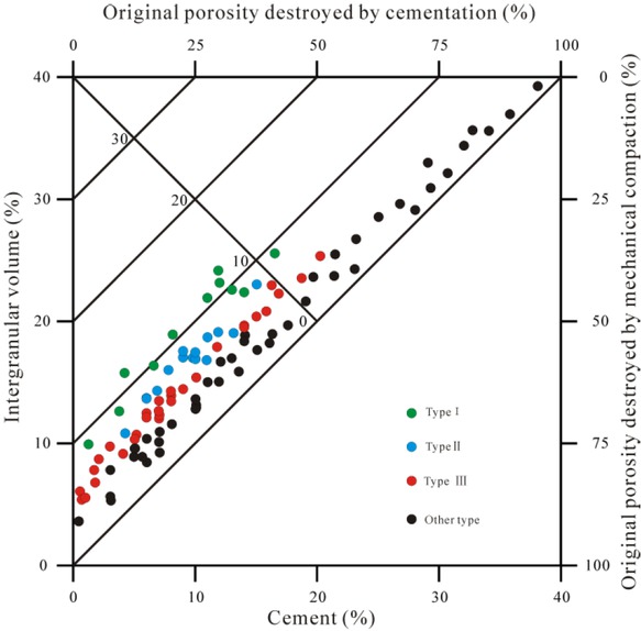
Plot of intergranular volume (IGV) vs. Cement volume and destruction of porosity by mechanical compaction vs. cementation.
It is clear that early intense compaction resulted in approximately the same degree of reduction of the original porosity for various sandstones. The difference in the degree of later cementation results in varying degrees of porosity reduction of each facies type (Figure 5).
In some samples of the Chang 8 sandstones, we found bitumen in the pores. This phenomenon indicates the presence of hydrocarbon emplacement. Hydrocarbon emplacement leads to the entry of fluid, rich in organic acids, into the pore system which inhibits the cementation in inorganic diagenetic environments and promotes the dissolution of feldspar and debris, forming secondary pores [46]. There are different degrees of dissolution in pore formation in the three facies, and the pore enhancement ranges from 0.5% to 7.3%. Among these facies, the facies I and II facies sandstone mainly exhibit dissolution along the edge of a primary pore. Meanwhile, for the facies III, the dissolution mainly occurs on the skeleton particles, due to the intense porosity loss caused by the early compaction and cementation. The intensity of the dissolution determines whether it can be an effective reservoir.
4.3.2 Different influences on permeability
The difference in permeability of each diagenetic facies is due to the difference in microscopic pore structure and clay minerals.
The comprehensive effect of compaction and cementation reduces the porosity and forms different pore structure types. The weaker the compaction is, the lesser the influence of cementation is. Stronger the dissolution, the better the primary pores and throats are preserved and corresponding to the less complexity of the pore structure and higher permeability (Figure 2g). Conversely, sandstones that have undergone complex diagenesis will exhibit poor porosity and permeability, which is not conducive to oil seepage.
As the clay minerals are mainly present along the wall of the pores and throats, the clay plays an important role in influencing the fluid seepage. In the main reservoir diagenetic facies, the faciesI andstone has a low degree of development of clay; The facies II sandstone is enriched in chlorite. The chlorite is present as grain coatings or pore lining, with a thickness ranging from 1 μm to 18 μm, and an average of 4.5 μm (Figure 6a). The facies III sandstone has characteristics illite development, mainly present in the form of flakes and silky grain (Figure 6b, c). Illite is mainly derived from the high temperature alternation conversion of other clay minerals and by-products of feldspar dissolution.
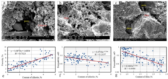
(a), (b) and (c): Microstructural characteristics of clay minerals. (e) and (f): Relationship between the content of chlorite and porosity/permeability. (g): Relationship between content of illite and permeability.
Due to the presence of chlorite and illite, the effective radius of seepage pore is reduced, and the clay minerals increase the internal specific surface area of the rock. Which enhances the sandstone’s binding capacities to the fluid (Figure 6f, g). Therefore, facies II and III sandstone exhibit a relatively poor permeability than facies I, in both absolute permeability and relative permeability test (Figure 2g,h; 3a-4, b-4, c-4). Note that although the primary porosity of both facies II and I are well preserved (Figure 6e),the development of chlorite in the facies II sandstone seriously damages to the permeability (Figure 6f).
5 Conclusions
To understand the control factors of reservoir quality and seepage property of tight sand oil reservoirs, we take the Chang 8 reservoir in the Maling Oilfield in the Ordos Basin as an example. Thin section, SEM, HPMI, NMR and water-oil relative permeability tests were performed on representative samples to analyzed the features of lithological and pore structure and fluid mobility. Some new insights are summarized as follows.
1. The Chang 8 sandstone exhibits low porosity and low permeability. The intense compaction leads to the general densification of sandstone during the early diagenesis stage. Different degree of carbonate cementation and dissolution in a later stage leads to the differentiation of reservoir quality and promotes the formation of different diagenetic facies. Facies I and II have contributed to better reservoir development.
2. Diagenesis reduces the porosity and changes the microscopic pore structure of the sandstone. The more complicated the pore structure, the worse the seepage property,
the stronger the interference of water on oil phase seepage. In all sandstones, when the water saturation exceeds 60%, the crude oil will completely lose its flowing capacity.
3. The presence of chlorite and illite in the reservoir reduces the effective pore radius, increases the internal specific surface area of the sandstone, and enhances binding to the fluid, which is an important factor for the reduction of reservoir permeability.
Acknowledgement
We thank the PetroChina Changqing Oilfield Company for providing samples and access to the data. This work is financially supported by the National Natural Science Foundation of China (No.51674211) and Youth Software Creative Engineering from Technological Office of SiChuan Province (No.2018058).
References
[1] Zou, C., Yang, Z., Tao, S.Z., Yuan, X.J., Zhu, R.K., Hou, L.H., Wu, S.T., Sun, L., Zhang, G.S., Bai, B.,Wang, L., Gao, X.H., Pang, Z.L., 2013. Continuous hydrocarbon accumulation over a large area as a distinguishing characteristic of unconventional petroleum: the Ordos basin, north-central China. Earth Sci. Rev. 126 (9), 358–369.10.1016/j.earscirev.2013.08.006Search in Google Scholar
[2] Olson, J.E., Laubach, S.E., Lander, R.H.,2009.Natural fracture characterization in tight gas sandstones: integrating mechanics and diagenesis. AAPG Bull. 93(11), 1535–154910.1306/08110909100Search in Google Scholar
[3] Rezaee, R., Saeedi, A., Clennell, B., 2012. Tight gas sands permeability estimation from mercury injection capillary pressure and nuclear magnetic resonance data. J. Pet. Sci. Eng. 88–89, 92–99.10.1016/j.petrol.2011.12.014Search in Google Scholar
[4] Ramstad, T., Idowu, N., Nardi, C., Øren, P.E., 2012. Relative permeability calculations from two-phase flow simulations directly on digital images of porous rocks. Transp Porous Media 94, 487-504.10.1007/s11242-011-9877-8Search in Google Scholar
[5] Raeini, A.Q., Bijeljic, B., Blunt, M.J., 2015. Modelling capillary trapping using finitevolume simulation of two-phase flow directly on micro-CT images. Adv. water Resour. 83, 102e110.10.1016/j.advwatres.2015.05.008Search in Google Scholar
[6] Loucks, R.G., Reed, R.M., Ruppel, S.C., Hammes, U., 2012. Spectrum of pore types and networks in mudrocks and a descriptive classification for matrix-related mudrock pores. AAPG Bull. 96, 1071–1098.10.1306/08171111061Search in Google Scholar
[7] Anovitz, L.M., Cole, D.R., 2015. Characterization and analysis of porosity and pore structures. Rev. Mineral. Geochem. 80 (1), 61–16410.1515/9781501502071-004Search in Google Scholar
[8] Schmitt, M., Fernandes, C.P., Wolf, F.G., Neto, J.A.B.C., Rahner, C.P., 2015. Characterization of Brazilian tight gas sandstones relating permeability and angstrom-to micron-scale pore structures. J. Nat. Gas Sci. Eng. 27, 785–807.10.1016/j.jngse.2015.09.027Search in Google Scholar
[9] Bai, B., Zhu, R.,Wu, S., Yang,W., Jeff, G., Allen, G., Zhang, X., Su, L., 2013. Multi-scale method of nano(micro)-CT study on microscopic pore structure of tight sandstone of Yanchang formation, Ordos basin. Pet. Explor. Dev. 40 (3), 329–333.10.1016/S1876-3804(13)60042-7Search in Google Scholar
[10] Daigle, H., Thomas, B., Rowe, H., Nieto, M., 2014. Nuclear magnetic resonance characterization of shallow marine sediments from the Nankai Trough, Integrated Ocean Drilling Program Expedition 333. J. Geophys. Res. 119, 2631–265010.1002/2013JB010784Search in Google Scholar
[11] Zhao, P., Wang, Z., Sun, Z., Cai, J., Wang, L., 2017. Investigation on the pore structure and multifractal characteristics of tight oil reservoirs using NMR measurements: Permian Lucaogou formation in Jimusaer sag, Junggar Basin. Mar. Pet. Geol. 86,1067–1081.10.1016/j.marpetgeo.2017.07.011Search in Google Scholar
[12] Shao, X., Pang, X., Jiang, F., Li, L., Huyan, Y., Zheng, D., 2017. Reservoir characterization of tight sandstones using NMR and IPMI experiments: implication for tight sand gas reservoir quality. Energy Fuel 31, 10420–1043110.1021/acs.energyfuels.7b01184Search in Google Scholar
[13] Verges, E., Tost, D., Ayala, D., Ramos, E., Grau, S., 2011. 3D pore analysis of sedimentary rocks. Sediment. Geol. 234, 109–115.10.1016/j.sedgeo.2010.12.005Search in Google Scholar
[14] Lai, J., Wang, G.W., Wang, S., Cao, J.T., Li, M., Pang, X.J.2018. Review of diagenetic facies in tight sandstones: diagenesis, diagenetic minerals, and prediction via well logs. Earth-Science Reviews,185, 234-258.10.1016/j.earscirev.2018.06.009Search in Google Scholar
[15] Kakouei, A., Masihi, M., Sola, B. S., & Biniaz, E. 2014. Lithological facies identification in iranian largest gas field: a comparative study of neural network methods. Journal of the Geological Society of India,84(3), 326-334.10.1007/s12594-014-0136-9Search in Google Scholar
[16] Maurya, S. P., & Singh, N. P. 2018. Application of lp and ml sparse spike inversion with probabilistic neural network to classify reservoir facies distribution - a case study from the black-foot field, canada. Journal of Applied Geophysics, 159, 511-521.10.1016/j.jappgeo.2018.09.026Search in Google Scholar
[17] Wang, G., & Carr, T.R.2012. Marcellus shale lithofacies prediction by multiclass neural network classification in the appalachian basin. Mathematical Geosciences, 44(8), 975-1004.10.1007/s11004-012-9421-6Search in Google Scholar
[18] Wang, G., Carr, T.R., Ju, Y., & Li, C. 2014. Identifying organic-rich marcellus shale lithofacies by support vectormachine classifier in the appalachian basin. Computers & Geosciences, 64(3), 52-60.10.1016/j.cageo.2013.12.002Search in Google Scholar
[19] Ma, C.L., R.J.Wang, B.L.Luo, W.B.Duan, C.Y.Feng, S.P.Wang, Y.X.Suo, Z.Z.Qiang 2012. Characteristics of Chang-8 Oil Reservoir and Distribution of Oil Reservoirs in Maling Oilfield, Ordos Basin. Natural Gas Geoscience. 23:514-519 (in Chinese with English abstract)Search in Google Scholar
[20] Wang, M., M.Zeng, H,A.Chen, G.Yang, J.F.Xu, H.B.QIU, H.G.Guo, J.M.Wang 2017. Influencing factors of tight reservoirs and favorable diagenetic facies:a case study of Chang 8 reservoir of the Upper Triassic Yanchang Formation in Maling Oilfield, Ordos Basin. Lithologic Reservoirs, 29: 59-70 (in Chinese with English abstract).Search in Google Scholar
[21] Yang,Y.X., Q.Huang, W.T.Liu, Q.Liu, B.Wang, Y.Wang 2015.Research of reservoir heterogeneity of shallow -water delta system,Ordos Basin:taking Chang 8 reservoir in Maling Oilfield as an example. Complex Hydrocarbon Reservoirs, 8:39-43 (in Chinese with English abstract).Search in Google Scholar
[22] Wu, F.L., Li, W.H., Li, Y.H., Xi, S.L. 2004. Delta sediment sand evolution of the Yanchang formation of Upper Triassic in Ordos basin. Journal of Palaeo-geography. 6(3):307-315Search in Google Scholar
[23] Luo, J.L., Li, Z.X., Shi, C.E., Li, J., Han, Y.L., Wang, H.H., Li, J.B., Li, Y.C.2008. depositional systems and provenance directions for the Chang 6 and Chang 8 reservoir groups of the Upper Triassic Yanchang Formation in the southwestern Ordos basin, China. Geologcal Bulletin of China, 27(1):101-111.Search in Google Scholar
[24] Li,W.H., Pang, J.G., Cao, H.X., Xiao, L.,Wang, R.G.2009. Depositional system and paleogeographic evolution of the late Triassic Yanchang Stage in Ordos Basin. Journal of Northwest university (natural gas edition) ,39(3):501-506.Search in Google Scholar
[25] Wang, L., Li, W.H., Lin, T.,Wang, R.G.2012.Diagenesis and its influencing factors of the Chang 6 interval of Upper Triassic Yanchang Formation in Ordos Basin. Journal of Palaeogeography, 14(3):311-320Search in Google Scholar
[26] Zou, C.N., L.Wang, Y.Li, S.Z.Tao, L.H.Hou 2012. Deep-lacustrine transformation of sandy debrites into turbidites, Upper Triassic, Central China. Sedimentary Geology. 265–266:143–15510.1016/j.sedgeo.2012.04.004Search in Google Scholar
[27] Yao, J.L.,Chu, M.J., Bai, C.E.,Yuan, X.M., Guo, Z.Q.2014. Sedimentary characteristics and genesis of thick layer sand body of Chang 82 sublayer in Ordos Basin. Lithologic Reservoirs,26(6):40-45Search in Google Scholar
[28] Yang, W., Liu, L., Li, S., Ji, H., Xu, Z., & Luo, Z., et al. 2017. The forming mechanism and process of tight oil sand reservoirs: a case study of chang 8 oil layers of the upper triassic yanchang formation in the western jiyuan area of the ordos basin, china. Journal of Petroleum Science & Engineering, 158, 29-46.10.1016/j.petrol.2017.08.026Search in Google Scholar
[29] Grigsby, J.D., Langford, R.P., 1996. Effects of diagenesis on enhanced-resolution bulk density logs in Tertiary Gulf Coast sandstones: an example from the Lower Vicksburg Formation, McAllen Ranch field, south Texas. AAPG Bull. 80, 1801–1819.10.1306/64EDA172-1724-11D7-8645000102C1865DSearch in Google Scholar
[30] Zou, C.N., Tao, S., Zhou, H., Zhang, X., He, D., Zhou, C.,Wang, L., Wang, X., Li, F., Zhu, R., 2008. Genesis, classification, and evaluation method of diagenetic facies. Pet. Explor. Dev. 35, 526–540.10.1016/S1876-3804(09)60086-0Search in Google Scholar
[31] Zeng, H.L., Zhu, X.M., Zhu, R.K., Zhang, Q.S., 2013. Seismic prediction of sandstone diagenetic facies: applied to Cretaceous Qingshankou Formation in Qijia Depression, Songliao Basin, East China. Pet. Explor. Dev. 40 (3), 287–295.10.1016/S1876-3804(13)60035-XSearch in Google Scholar
[32] Fu, G.M., Qin, X.L., Miao, Q., Zhang, T.J., Yang, J.P., 2009. Division of diagenesis reservoir facies and its control case study of Chang-3 reservoir in Yangchang Formation of Fuxian exploration area in Northern Shaanxi. Int. J. Min. Sci. Technol. 19 (4),537-54310.1016/S1674-5264(09)60101-0Search in Google Scholar
[33] Ozkan, A., Cumella, S.P., Milliken, K.L., Laubach, S.E., 2011. Prediction of lithofacies and reservoir quality using well logs, Late Cretaceous Williams Fork Formation, Mamm Creek field, Piceance Basin, Colorado. AAPG Bull. 95 (10), 1699–172310.1306/01191109143Search in Google Scholar
[34] Liu, H., Zhao, Y., Luo, Y., Chen, Z., He, S., 2015. Diagenetic facies controls on pore structure and rock electrical parameters in tight gas sandstone. J. Geophys. Eng. 12 (4), 587–600.10.1088/1742-2132/12/4/587Search in Google Scholar
[35] Carvalho, A.D.S.G., De Ros, L.F., 2015. Diagenesis of Aptian sandstones and conglomerates of the Campos basin. J. Pet. Sci. Eng. 125, 189–200.10.1016/j.petrol.2014.11.019Search in Google Scholar
[36] Ran, Y.,Wang, G., Lai, J., Zhou, Z., Cui, Y., Dai, Q., Chen, J.,Wang, S., 2016. Quantitative characterization of diagenetic facies by using logging crossplot: a case study on Chang 7 tight sandstone oil reservoir in Heshui area, Ordos Basin. Acta Sedimentol. Sin. 34 (4), 694–706.Search in Google Scholar
[37] Lai, J., Wang, G., Chai, Y., Ran, Y., 2016. Prediction of diagenetic facies using well logs: evidences from Upper Triassic Yanchang Formation Chang 8 sandstones in Jiyuan Region, Ordos Basin, China. Oil Gas Sci. Technol. 71, 34.10.2516/ogst/2014060Search in Google Scholar
[38] Nabawy, B.S., Géraud, Y., Rochette, P., Bur, N., 2009. Porethroat characterization in highly porous and permeable sandstones. AAPG Bull. 93 (6), 719–739.10.1306/03160908131Search in Google Scholar
[39] Müller-Huber, E., Schön, J., Börner, F., 2016. Pore space characterization in carbonate rocks—approach to combine nuclear magnetic resonance and elastic wave velocity measurements. J. Appl. Geophys. 127, 68–81.10.1016/j.jappgeo.2016.02.011Search in Google Scholar
[40] Torabi, F., Mosavat, N., Zarivnyy, O., 2016. Predicting heavy oil/water relative permeability using modified Corey-based correlations. Fuel 163, 196–204.10.1016/j.fuel.2015.09.035Search in Google Scholar
[41] Zhang, N., Yan, B., Sun, Q.,Wang, Y., 2017. Improving multiscale mixed finite element method for flow simulation in highly heterogeneous reservoir using adaptivity. J. Petrol. Sci. Eng. 154, 382–388.10.1016/j.petrol.2017.04.012Search in Google Scholar
[42] Paxton, S.T., Szabo, J.O., Ajdukiewicz, J.M., Klimentidis, R.E., 2002. Construction of an intergranular volume compaction curve for evaluating and predicting compaction and porosity loss in rigid-grain sandstone reservoirs. The American Association of Petroleum Geologists Bulletin 86, 2047–2067.10.1306/61EEDDFA-173E-11D7-8645000102C1865DSearch in Google Scholar
[43] Salem, A. M. (2005). Diagenesis and reservoir-quality evolution of incised-valley sandstones: evidence from the abu madi gas reservoirs (upper Miocene), the Nile delta basin, Egypt. Journal of Sedimentary Research, 75(4), 572-584.10.2110/jsr.2005.047Search in Google Scholar
[44] Beard, D.C., Weyl, P.K., 1973. Influence of texture on porosity and permeability of unconsolidated sand. AAPG Bull. 57:349-36910.1306/819A4272-16C5-11D7-8645000102C1865DSearch in Google Scholar
[45] Ehrenberg, S.N., Nadeau, P.H., 1989. Formation of diagenetic illite in sandstones of the Garn Formation, Haltenbanken area, mid-Norwegian continental shelf. Clay Minerals 24, 233–253.10.1180/claymin.1989.024.2.09Search in Google Scholar
[46] Zheng, Q.H., Y.Q.Liu 2015. The Diagenesis and Diagenetic Lithofacies of Tight Reservoir of Chang 4+5 Member of Yanchang Formation in Huaqing Area, Ordos Basin. Advances in Earth Science, 30:78-89 (in Chinese with English abstract).Search in Google Scholar
© 2019 Meng Wang et al., published by De Gruyter
This work is licensed under the Creative Commons Attribution 4.0 Public License.
Articles in the same Issue
- Regular Articles
- 2D Seismic Interpretation of the Meyal Area, Northern Potwar Deform Zone, Potwar Basin, Pakistan
- A new method of lithologic identification and distribution characteristics of fine - grained sediments: A case study in southwest of Ordos Basin, China
- Modified Gompertz sigmoidal model removing fine-ending of grain-size distribution
- Diagenesis and its influence on reservoir quality and oil-water relative permeability: A case study in the Yanchang Formation Chang 8 tight sandstone oil reservoir, Ordos Basin, China
- Evaluation of AHRS algorithms for Foot-Mounted Inertial-based Indoor Navigation Systems
- Identification and evaluation of land use vulnerability in a coal mining area under the coupled human-environment
- Hydrocarbon Generation Potential of Chia Gara Formation in Three Selected Wells, Northern Iraq
- Source Analysis of Silicon and Uranium in uranium-rich shale in the Xiuwu Basin, Southern China
- Lithologic heterogeneity of lacustrine shale and its geological significance for shale hydrocarbon-a case study of Zhangjiatan Shale
- Characterization of soil permeability in the former Lake Texcoco, Mexico
- Detrital zircon trace elements from the Mesozoic Jiyuan Basin, central China and its implication on tectonic transition of the Qinling Orogenic Belt
- Turkey OpenStreetMap Dataset - Spatial Analysis of Development and Growth Proxies
- Morphological Changes of the Lower Ping and Chao Phraya Rivers, North and Central Thailand: Flood and Coastal Equilibrium Analyses
- Landscape Transformations in Rapidly Developing Peri-urban Areas of Accra, Ghana: Results of 30 years
- Division of shale sequences and prediction of the favorable shale gas intervals: an example of the Lower Cambrian of Yangtze Region in Xiuwu Basin
- Fractal characteristics of nanopores in lacustrine shales of the Triassic Yanchang Formation, Ordos Basin, NW China
- Selected components of geological structures and numerical modelling of slope stability
- Spatial data quality and uncertainty publication patterns and trends by bibliometric analysis
- Application of microstructure classification for the assessment of the variability of geological-engineering and pore space properties in clay soils
- Shear failure modes and AE characteristics of sandstone and marble fractures
- Ice Age theory: a correspondence between Milutin Milanković and Vojislav Mišković
- Are Serbian tourists worried? The effect of psychological factors on tourists’ behavior based on the perceived risk
- Real-Time Map Matching: A New Algorithm Integrating Spatio-Temporal Proximity and Improved Weighted Circle
- Characteristics and hysteresis of saturated-unsaturated seepage of soil landslides in the Three Gorges Reservoir Area, China
- Petrographical and geophysical investigation of the Ecca Group between Fort Beaufort and Grahamstown, in the Eastern Cape Province, South Africa
- Ecological risk assessment of geohazards in Natural World Heritage Sites: an empirical analysis of Bogda, Tianshan
- Integrated Subsurface Temperature Modeling beneath Mt. Lawu and Mt. Muriah in The Northeast Java Basin, Indonesia
- Go social for your own safety! Review of social networks use on natural disasters – case studies from worldwide
- Forestry Aridity Index in Vojvodina, North Serbia
- Natural Disasters vs Hotel Industry Resilience: An Exploratory Study among Hotel Managers from Europe
- Using Monarch Butterfly Optimization to Solve the Emergency Vehicle Routing Problem with Relief Materials in Sudden Disasters
- Potential influence of meteorological variables on forest fire risk in Serbia during the period 2000-2017
- Controlling factors on the geochemistry of Al-Shuaiba and Al-Mejarma coastal lagoons, Red Sea, Saudi Arabia
- The Influence of Kaolinite - Illite toward mechanical properties of Claystone
- Two critical books in the history of loess investigation: ‘Charakteristik der Felsarten’ by Karl Caesar von Leonhard and ‘Principles of Geology’ by Charles Lyell
- The Mechanism and Control Technology of Strong Strata Behavior in Extra-Thick Coal Seam Mining Influenced by Overlying Coal Pillar
- Shared Aerial Drone Videos — Prospects and Problems for Volunteered Geographic Information Research
- Stable isotopes of C and H in methane fermentation of agriculture substrates at different temperature conditions
- Prediction of Compression and Swelling Index Parameters of Quaternary Sediments from Index Tests at Mersin District
- Detection of old scattered windthrow using low cost resources. The case of Storm Xynthia in the Vosges Mountains, 28 February 2010
- Remediation of Copper and Zinc from wastewater by modified clay in Asir region southwest of Saudi Arabia
- Sedimentary facies of Paleogene lacustrine dolomicrite and implications for petroleum reservoirs in the southern Qianjiang Depression, China
- Correlation between ore particle flow pattern and velocity field through multiple drawpoints under the influence of a flexible barrier
- Atmospheric refractivity estimation from AIS signal power using the quantum-behaved particle swarm optimization algorithm
- A geophysical and hydro physico-chemical study of the contaminant impact of a solid waste landfill (swl) in King Williams’ Town, Eastern Cape, South Africa
- Landscape characterization using photographs from crowdsourced platforms: content analysis of social media photographs
- A Study on Transient Electromagnetic Interpretation Method Based on the Seismic Wave Impedance Inversion Model
- Stratigraphy of Architectural Elements of a Buried Monogenetic Volcanic System
- Variable secondary porosity modeling of carbonate rocks based on μ-CT images
- Traditional versus modern settlement on torrential alluvial fans considering the danger of debris flows: a case study of the Upper Sava Valley (NW Slovenia)
- The Influence of Gangue Particle size and Gangue Feeding Rate on Safety and Service Life of the Suspended Buffer’s Spring
- Research on the Transition Section Length of the Mixed Workface Using Gangue Backfilling Method and Caving Method
- Rainfall erosivity and extreme precipitation in the Pannonian basin
- Structure of the Sediment and Crust in the Northeast North China Craton from Improved Sequential H-k Stacking Method
- Planning Activities Improvements Responding Local Interests Change through Participatory Approach
- GIS-based landslide susceptibility mapping using bivariate statistical methods in North-western Tunisia
- Uncertainty based multi-step seismic analysis for near-surface imaging
- Deformation monitoring and prediction for residential areas in the Panji mining area based on an InSAR time series analysis and the GM-SVR model
- Statistical and expert-based landslide susceptibility modeling on a national scale applied to North Macedonia
- Natural hazards and their impact on rural settlements in NE Romania – A cartographical approach
- Rock fracture initiation and propagation by mechanical and hydraulic impact
- Influence of Rapid Transit on Accessibility Pattern and Economic Linkage at Urban Agglomeration Scale in China
- Near Infrared Spectroscopic Study of Trioctahedral Chlorites and Its Remote Sensing Application
- Problems with collapsible soils: Particle types and inter-particle bonding
- Unification of data from various seismic catalogues to study seismic activity in the Carpathians Mountain arc
- Quality assessment of DEM derived from topographic maps for geomorphometric purposes
- Remote Sensing Monitoring of Soil Moisture in the Daliuta Coal Mine Based on SPOT 5/6 and Worldview-2
- Utilizing Maximum Entropy Spectral Analysis (MESA) to identify Milankovitch cycles in Lower Member of Miocene Zhujiang Formation in north slope of Baiyun Sag, Pearl River Mouth Basin, South China Sea
- Stability Analysis of a Slurry Trench in Cohesive-Frictional Soils
- Integrating Landsat 7 and 8 data to improve basalt formation classification: A case study at Buon Ma Thuot region, Central Highland, Vietnam
- Assessment of the hydrocarbon potentiality of the Late Jurassic formations of NW Iraq: A case study based on TOC and Rock-Eval pyrolysis in selected oil-wells
- Rare earth element geochemistry of sediments from the southern Okinawa Trough since 3 ka: Implications for river-sea processes and sediment source
- Effect of gas adsorption-induced pore radius and effective stress on shale gas permeability in slip flow: New Insights
- Development of the Narva-Jõesuu beach, mineral composition of beach deposits and destruction of the pier, southeastern coast of the Gulf of Finland
- Selecting fracturing interval for the exploitation of tight oil reservoirs from logs: a case study
- A comprehensive scheme for lithological mapping using Sentinel-2A and ASTER GDEM in weathered and vegetated coastal zone, Southern China
- Sedimentary model of K-Successions Sandstones in H21 Area of Huizhou Depression, Pearl River Mouth Basin, South China Sea
- A non-uniform dip slip formula to calculate the coseismic deformation: Case study of Tohoku Mw9.0 Earthquake
- Decision trees in environmental justice research — a case study on the floods of 2001 and 2010 in Hungary
- The Impacts of Climate Change on Maximum Daily Discharge in the Payab Jamash Watershed, Iran
- Mass tourism in protected areas – underestimated threat? Polish National Parks case study
- Decadal variations of total organic carbon production in the inner-shelf of the South China Sea and East China Sea
- Hydrogeothermal potentials of Rogozna mountain and possibility of their valorization
- Postglacial talus slope development imaged by the ERT method: comparison of slopes from SW Spitsbergen, Norway and Tatra Mountains, Poland
- Seismotectonics of Malatya Fault, Eastern Turkey
- Investigating of soil features and landslide risk in Western-Atakent (İstanbul) using resistivity, MASW, Microtremor and boreholes methods
- Assessment of Aquifer Vulnerability Using Integrated Geophysical Approach in Weathered Terrains of South China
- An integrated analysis of mineralogical and microstructural characteristics and petrophysical properties of carbonate rocks in the lower Indus Basin, Pakistan
- Applicability of Hydrological Models for Flash Flood Simulation in Small Catchments of Hilly Area in China
- Heterogeneity analysis of shale reservoir based on multi-stage pumping data