Hydrogeothermal potentials of Rogozna mountain and possibility of their valorization
-
D. R. Ivanović
 ,
R. D. Srećković-Batoćanin
,
R. D. Srećković-Batoćanin

Abstract
The subjects of this study are hydrogeothermal potentials of Rogozna mountain (Serbia) and possibility of their use. Thermo-mineral springs at the mountain’s foothill are the leftovers from an intensive volcanic activity during the Tertiary. The most famous and the most valuable ones are the springs in Novopazarska Spa, Banjska and in the village of Vuca, with a number of springs yet to be examined. The hydrogeothermal potential of these springs is significant, with the total thermal power of 4.6 MWt and the thermal energy of 145.4 TJ/year, but these could be greatly enlarged through the additional investigation in the interior of Rogozna. It is believed that the primary reservoir lies at the approximate depth of 2 km and that the water temperature is about 120∘C. In the area of Rogozna mountain there are a lot of thermomineral springs (TM) with outlet temperature between 30 and 54∘C. The main goal of this study is to determine the thermo-mineral capacity and energy potential in the area of three spas. This study allows the hypothesis that thermo-mineral springs in the area of Rogozna mountain have large potential. The researched area of Rogozna mountain is insufficiently investigated geo-space, which is rich in thermo-mineral springs. Thermal sources in Rogozna mountain produce heat power of 4.6MWt or 1.4% of heat power given by all the sources in Serbia. The waters of these springs are solely used for balneological and recreational purposes. Yet they could successfully be used in warming and cooling the space, for greenhouses in fruit, vegetable and flower production. In the end, all geospatial data with the help of GIS advanced techniques were digitized and visualized.
1 Introduction
Energy is essential to life and its continuous and ubiquitous supply brings much needed economic growth and prosperity to a region [1]. Biomass, tidal power, sea waves, solar, geothermal, hydropower energy as the primary ones, belong to renewable kinds of energy. The kinds of energy such as coal, oil and gas, nuclear energy belong to nonrenewable energy. The role of mentioned energy resources has been changed in time, structure and quantities, being in accordance with the advance and changes in production processes, and with implementation of scientific knowledge. The technological achievements are very important for discovering, exploitation and transport of fuel and its efficient use [2]. In the next twenty years, we may expect increase in the use of renewable energy at global scale [47]. The members of the International Energy Agency (IEA) emphasized that the continuation of growing development trends in the world, would raise the use of energy for 60% until 2020, and that the highest consumption would be recorded in developing countries. Oil, coal and natural gas as well as nuclear fission energy will dominate and their largest sources will be concentrated only in several countries. The enormous part of world population will experience a lack of energy supply, although the global growing trend for energy is about 2.8% annually [2]. The solution of problems lies in the further investigation of renewable energy resources. Significant and large reservoir of energy on the Earth is geothermal energy, which should not be neglected in the 21st century [49]. Compared to wind and solar energy, geothermal energy can’t be affected by changes of weather, meteorological conditions and seasons. Geothermal energy is one of the most realistic and competitive resources in renewable energy [3]. Geothermal energy can be: [4]
Hydrogeothermal energy – the energy of underground waters.
In the area of Rogozna mountain, there is a huge geothermal potential underground, with the volume of low enthalpy. (< 100∘C) [13].
Hydrogeothermal energy with low enthalpy can be [39]:
Sub hydrogeothermal energy with temperature of fluids to 30∘C
Hydrogeothermal energy with temperature of fluids between 30∘C to 100∘C.
It has been estimated that the reserves of geothermal energy notably exceed reserves of coal, oil, natural gas and uranium all together. The advantages of geothermal energy use are in its contribution to the economics as well as to the preservance of life environment [13, 39, 41].
Disadvantages of geothermal energy use are: [40]
There are not a lot of places where geothermal electricity station could be constructed (depending on position, depth, temperature, and the amount of water in a geothermal reservoir),
Limited access to final users
Insufficiently investigated capacity and potentials
High start-up capital (the beginning of use and improvement) and high cost of maintenance (caused by corrosion, scaling etc.).
Geothermal energy has been used for balneological and recreational purposes since the beginning of time – the healing and the recovery of the disease by drinking, bathing or using peloids. Its usage in the production of electric energy, warming and cooling rooms, agriculture and other purposes dates back to the beginning of the past century [43, 49]. Geothermal springs are used in over 70 countries of the world, while the electric energy is producing in 25 countries [5].
The reasons for using geothermal energy as a substitute for fossil fuels are multiple:
This kind of energy is practically inexhaustible as it constantly obtains warmth from the inside parts of the Earth;
Gas emission with the greenhouse effect is reduced to a minimum;
The costs of geothermal energy for sports and recreations and heating of space are equal 2-5 Euro-cents/kWh and for heating throughout the whole season is 1-6 Eurocents/kWh. The prices of other types are as follows: natural gas 7.0 Eurocents/kWh, electrical energy – 6.0 Eurocents/kWh, energy derived from thermal plants – 7.0 Eurocents/kWh [6].
It is minimally detrimental to the living environment;
There is no need for energy storage space.
Despite its significant potential, the total contribution of the geothermal sector to global power generation remains relatively small. The International Energy Agency has recommended devising plans to address technology-specific challenges to achieve faster growth and improving policies tackling pre-development risks for geothermal energy [7]. The European Union (EU) according to energy politics and issue launched for 2010-2031 provided following aims for reducing the emission of gases with the greenhouse effects. The developed countries must reduce emissions of gasses to 30% until 2020. Also, these countries must upgrade energy efficiency to 20% until 2020, and enlarge the rate of renewable energy for 20% until 2020 [8, 9, 10]. The Kyoto and EU directives aid much the renewable energy development in the Balkans [11]. Law regulations in Serbia intend to be in accordance with the Kyoto and EU directives on renewable energy resources. Serbia is very rich in hydrogeothermal energy resources. A number of natural thermal springs with water of temperature exceeding 15∘C in Serbia is about 240 [12]. Total discharge in the territory of Serbia for all natural springs is approximately 4700 l/s [13, 14, 15]. Thermal springs from karstified limestones of Mesozoic age are of the highest discharge, but those within volcanic and granitoid rocks of Tertiary age are not less important. Approximately 60% of all thermal and thermo-mineral springs are with water with temperature 20 to 40∘C; water in about 20% is from 30 to 40∘C and in about 20% the water temperature exceeds 40∘C [14]. The sources of the highest temperature are Vranjska Spa (96∘C), Jošanička Spa (78∘C), Sijarinska Spa (76∘C), Kuršumlijska Spa (68∘C) and Novopazarska Spa (54∘C) [13]. Estimated capacity of geothermal energy in Serbia is 104.5 MWt although geothermal potential is much higher [15]. The total heat capacity of all hydrogeothermal drill holes in Serbia is about 188 MWt, where 80.3 MWt are in Pannonian basin [15]. The total heat capacity (power) of all natural TM springs in Serbia and hydrogeothermal drill holes (wells) is about 320 MWt [12]. The usable potential of renewable energy sources in Republic of Serbia is significant and estimated to 5.6 Mtoe per year, of which about 0.2 Mtoe (8.37 PJ-8373.60000 TJ) belong to the existing geothermal sources [16]. According to the estimated capacity of geothermal energy, Serbia is at the 36th place [17]. In Serbia, geothermal energy is used for balneology, sports, curative and medical purposes, and very rarely for heating and power. Geothermal energy in Serbia should be more important for heating in cities and improvement of agriculture, i.e. in food production in accordance with ecological standards. In the near future it could be also important for the production of electric energy. In spite of number of geothermal springs, this energy is used only in about 30 spas well-known to tourists, still in traditional ways, balneology and sport-recreation activities. Multi-purpose application of it is still in the initial stage and very modest regarding potential and resources. The objective of this work is to show the geothermal potential of Rogozna mountain with a focus on hydrogeothermal potential, the current state and the possibilities of its use in the future.
2 Study area
Rogozna is a mountain in the southwest part of Serbia (Figure 1; downloaded from (https://earthexplorer.usgs.gov/), situated in a triangle composed of the river flows of the upper and central flow of the Ibar river and the Raška river [18]. Its northern parts gradually come down towards Novi Pazar Valley, its southern parts are, to an extent, steeper and belong to the micro region of Ibarski Kolašin in Kosovo and Metohija. To the east, it gently ascends towards the composite valley of the middle Ibar and it is connected to Ninaja Mountain and to a mountain chain on the Serbia-Montenegro border to the west. This mountain was built of massive blocks with height between 800 m and 1500 m. It spans in the direction of NW to SE, about 20 km of length. Certain peaks rise from its plateau such as Bubski Šiljak (1284 m), Mliječnjak (1385 m), and Jelač (1262m). The highest peak is Crni Vrh (1504 m) in the southwestern part of the mountain. Rogozna Mountain has always been known for its natural ores, forests and thermomineral springs. Mining was developed during the Roman time revealing the name for the mountain – Monte argentato [19]. Today‘s name is actually the name of an old mining settlement from the Middle Ages. Although reserves have not been fully discovered yet, it is known that the mountain possesses considerable quantities of lead, zinc, silver, gold, copper, chrome, cobalt, nickel, asbestos and other metals and non-metals [20].
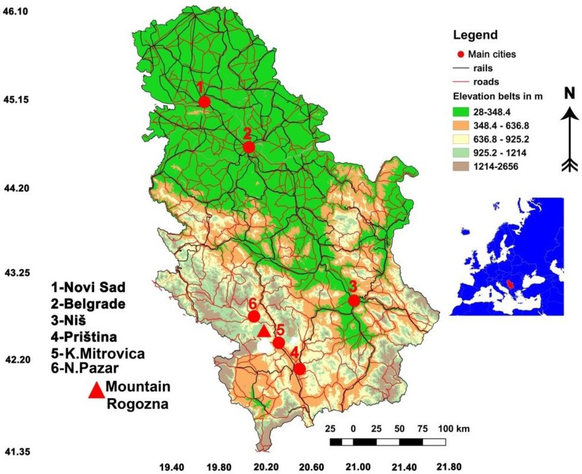
Position of Rogozna Mountain in Serbia and in Europe, accorodng to sattelite data of 30 m, resolution downloaded from (https://earthexplorer.usgs.gov/).
3 Geotectonic features of Rogozna Mountain
The Rogozna Mts. volcanic complex developed within the complex structure that was left behind after the closure of Mesozoic Tethys [21]. Its very basement is represented by Upper Cretaceous flysch of Kosovska Mitrovica which seals the immediate contact between the ophiolite mélange of the Vardar Zone and the Drina–Ivanjica metamorphic unit in the east and west, respectively [22]. The oldest rocks are metamorphic rocks - amphibolites and micaschists, with little marble in deeper parts and sericite chlorite schists, quartzites, marbles, metamorphosed limestones and diabase in higher parts. The wider distribution has mélange especially in the central parts. It consists of igneous (gabbro and diabase) and of sedimentary (sandstones, clay, flysh, breccia and conglomerate) rocks. Cretaceous sediments (Senonian) are represented by zoogenic rudist reef limestones and marls at lower levels, wherea the flysch at higher levels. Flysch sediments are deeply embedded, covered by Neogene products. During the Tertiary, the Rogozna territory was exposed to an intense magmatic activity. The volcanic and pyroclastic rocks of Rogozna were formed at three stages between the Early Miocene and Quaternary. The first stage produced dacitoandesite, the second one produced dacites and quartz latites, and the third one gave latites (Figure 2). The second stage was particularly explosive with frequent eruptions of exquisite pyroclastic character [23].
![Figure 2 Map of the main tectonostratigraphic units of the Central Balkan Peninsula [64], with the location of the Crnac Pb–Zn–Ag deposit. (b) Geological sketch map of Rogozna Mt. [65], with marked sampling locations of the surface quartz latite. According to [66].](/document/doi/10.1515/geo-2019-0083/asset/graphic/j_geo-2019-0083_fig_002.jpg)
4 Hydrogeothermal features of Rogozna mountain
The intensive volcanic activity during the Tertiary generated and left behind the thermal springs at the foothill of the mountain. On the northern slopes of Rogozna mountain, high temperature water emerges in two places, which became spa, i.e. Novopazarska Spa. At the eastern edge of Rogozna mountain, there is a spring in the village of Vuča, in the Municipality of Leposavić, and at the southeastern edge, there are springs in the village of Banjska, in the Municipality of Zvečan. In the surroundings of Banjska, there are a couple of more springs, but they have not been fully examined (e.g. Josevik). At the same time, on the southern slopes of Rogozna mountain, in the Municipality of Zubin Potok, there are a few springs. The spring in the village of Banja is inundated by the accumulation of the Gazivode lake, while the spring in the village of Lučka Reka is not examined [18]. The waters in these springs are similar and belong to the HCO3-Na type, with nitrogen (N2) as the prevailing gas. Their pH values are also similar (6.7-6.8), excluding the Vuča Spring where pH value is 8.4 [24, 25] (Table 1). There are 14 thermal sources in Novopazarska Spa, generally of small discharge and of average mineralization of 1.7 g/kg and pH 6.8. Sources are distributed within the NW-SE striking zone. The main source discharges 1.01 l/s of water with temperature 54∘C. Prevailing microconstituents are H2S, SiO2, F, Li, Sr, Rb, and Cs. Concerning radioactive elements the elevated amount of 0.28 Bq/l is recorded for radium (Ra) and low contents of Rn and U: 9.25 Bq/l and 0.0006 mg/l. Thermal sources occur in the Upper Cretaceous flysch sediments, which display nearly vertical bedding in the area of spa. Hence the relation of thermal sources with relatively narrow and elongated synclinorium extending NW-SE, i.e. within the Triassic limestones in its base is expected [24, 25, 26]. There are several thermal sources in the Banjska area. Larger once with the water temperature from 31.5∘C to 54∘C, and of average mineralization 1.36 g/l, and pH 6.7 are already captured. Similar chemistry of water in different thermal springs reflects on their same source. The level of radioactive elements is low. Thermal water emanates all the way through the large reverse fault that separates Senonian flysch (in the west) and ultrabasic rocks (in the east and northeast). Along this reverse fault, different wall-rock alterations could be observed [24, 25, 26]. Vuča Spring has only one source with discharge of 0.8 l/s, temperature 30∘C, average mineralization 0.30 g/l and pH value of 8.4. Specific components are H2S, F, Mn, and a whereas radioactive elements occur in negligible amounts. Thermal waters reach the surface in the area built by volcanic rocks, diabase-chert formation, Cretaceous flysch and Proterozoic metamorphic rocks. Large masses of peridotite are exposed western from thermal source, which is placed in limestones that are in tectonic contact with metamorphic rocks and Cretaceous flysch [24, 25, 26].
Locations of thermal-mineral springs with their chemical and physical characteristics [24].
| Locality | T∘C | pH | Gas Systems | Specific components | Ways of Occurence | Class |
|---|---|---|---|---|---|---|
| Novopazarska Spa | 30-54 | 6.8 | N2 | H2S, Ra, F, Li, Sr, Rb, Cs, SiO2 | Several springs Two explored drill holes | HCO3-Na |
| Banjska Spa | 31.5-54 | 6.7 | N2 | H2S, F, Li, Ba, Sr, SiO2 | 4 springs | HCO3-Na |
| Vuča Spring | 30 | 8.4 | N2 | H2S, F, Mn, As | One spring | HCO3-Na |
The uses of these springs including some losses and costs;
The location of a user is very important. The most economical uses are in the city or in the surrounding area of the spring with maximum 8 km of distance [43].
The accommodation capacity and location of potential users of the Novopazarska and Banjska spas are in the surrounding area of springs. In that way we have the main precondition to open these resources [44].
If thermal-mineral waters are chemically benign, they will be directly used. However, waters of the three spas contain huge concentration of minerals (Table 1).
It would be necessary to carry out the chemical and mechanical modifications which would mitigate damage of corrosion, especially in the pipes and water supply.
The object for the use of geothermal energy must be built with special isolation materials.
The climatic condition in the spas is represented by low temperatures, thus the increase of cost may be expected in the greenhouses because the additional energy, such as electric or energy derived from oils is needed.
• For the use of water in baths and pools for medical treatment it will be necessary to make calculation for potential loss of renewable energy. In the indoor pools it’s necessary to take acclimatization. In the outdoor pools the large loss is present in evaporation of water (50-60%) [44].
5 Hydrogeothermal potential of Rogozna mountain
The hydrogeothermal potential of Rogozna mountain is determined by thermal power and thermal energy of thermomineral springs which emerge at its foothill. Where exhaustibility stands for the amount of water which emerges from the springs in 1/s the inlet temperature is the temperature which emerges upon the surface. The Equation 1 explains the way we have calculated total geothermal power.
where
Q – is heat power (MWt)
FRmax – is maximal discharge (l/s) [42]
Ti – is inlet (ThM) water temperature (∘C)
To – is outlet (ThM) water temperature of (∘C)
The total energy of (ThM) waters is given by the following Equation.
where,
Euse – is energy use (TJ/year)
FRavg – is average discharge (l/s) [42]
Geothermal energy loses its own energy in the pipes, and the volume of loss depends on the kind and length of pipes, and of the outside temperature. The loss of energy is given for all spas (Banjska, Novopazarska and Vuča), as well as for pipes with isolation (wool) and without isolation (chromium pipe) with the outside temperature of 0∘C and length of pipe 1 m, according to the Equation 3. [45, 49]
Without;
Where l is a length of pipe, ϑi is temperature in the pipe, ϑi+1 is temperature of outside air, λ is coefficient of resistance, and r1, r2, r3 are semi-radius. For the spa of Banjska where the capacity of discharge is 5 l/s and the water temperature is 50∘C, with velocity of 1.5 m/s and pipe with radius of 65 mm, and thickness of wool used like isolator of 2.5 mm, at the outside temperature of 0∘C, the calculated loss of energy is 0.01341 kW/m with isolator and 0.0523 kW/m without isolator. The capacity of spring in Novopazarska spa is 10 l/s. Using pipe with radius of 92 mm, and width of 2.5 mm and with 50 mm of wool at the outside temperature of 0∘C, the loss of energy for included 1 m of pipe with isolator is 0.01752 kW, and without isolator is 0.10885 kW. Thermo-mineral spring in the spa of Vuča has capacity of 0.8 l/s. With temperature of 30∘C, the loss of energy in the pipe with isolator would be 0.00683 kW/m, and without 0.081913 kW/m. Obtained results help authors in their search for a way to implement thermal sources and spas including their estimated capacities as the renewable energy sources in satisfying the needs for energy, an increase of its efficiency, as well as in attempt to reduce the use of fossil fuels. The types of geothermal energy use in Serbia are: I = Industrial process heat; H = Individual space heating (other than heat pumps); C = Air conditioning (cooling); D = District heating (other than heat pumps); A = Agricultural drying (grain, fruit, and vegetables); B = Bathing and swimming (including balneology); F = Fish farming; G = Greenhouse and soil heating; K = Animal farming; O = Other; S = Snow melting. About 40% of energy needed for these can be satisfied by hydrogeothermal potential in the Rogozna mountain [12, 60, 62] (Figure 3).
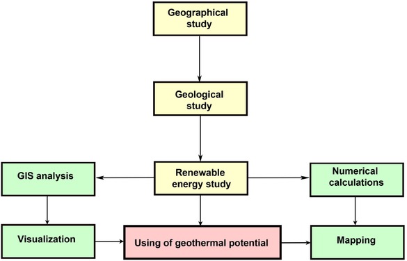
Flowchart of research methodology.
6 GIS numerical analysis
In this research we used numerical advanced Geographical Information System (GIS). With the help of GIS techniques, we successfully estimated energy capacity and properties of thermo-mineral springs in the area of the Rogozna Mountain. GIS and data modeling is a very powerful tool for calculating properties of thermo-mineral springs. GIS may also estimate indoor and outdoor temperatures of thermo-mineral springs. The main springs are located in the fault zone of Rogozna. In this research we used open-source software such as QGIS and SAGA. With the help of methods like kriging, semi-kriging and interpolation we got dispersion of all temperatures in the researched areas (Figure 3; Figure 4; Figure 5) [27]. The satellite recordings data were downloaded from the official web page of USGS (United States Geological Survey) and from the official web page Earth Explorer – LAND SAT (http://earthexplorer.usgs.gov/). The Aster Global Dem data with the exceptional view of Digital Elevation data were also downloaded. The digital elevation data is necessary for the precise calculation of thermal-mineral springs and determining its elevation [28, 63] (Figure 4 and Figure 5). Ordinary kriging method was employed through QGIS and SAGA (GIS) with the help of special algorithm called Spatial Analyst because it includes autocorrelation of the statistical relationship among measured points [29]. Thus, with this method, the weights are based not only on the distance between the measured points and the prediction of location but also on the overall spatial arrangement of the measured points and it minimizes the variance of the error of estimation. In this research we also used special self-created software for calculating geothermal power and estimated power of geothermal capacity. This software was created in python code and successfully implemented in QGIS software. The software has calculated the belts of geothermal power in the presented maps. By this action we accelerate the process of digitization and visualization on the maps [61].
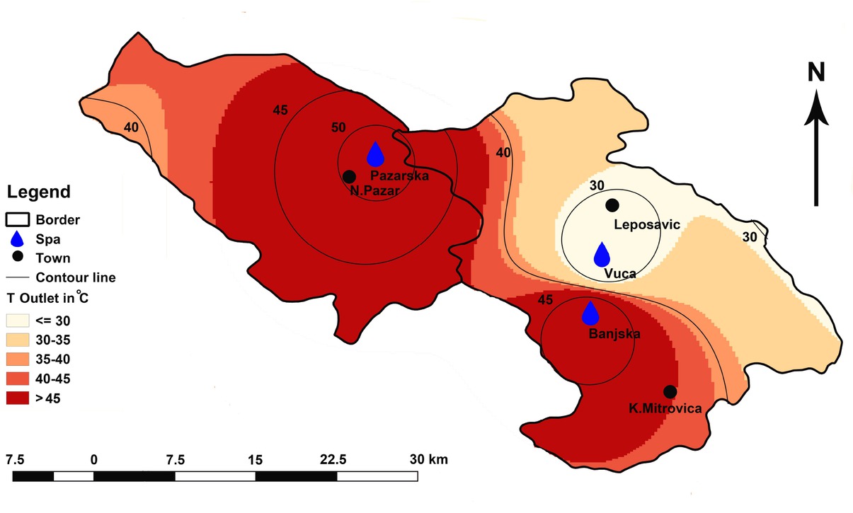
Spas with outlet dispersions of temperatures.
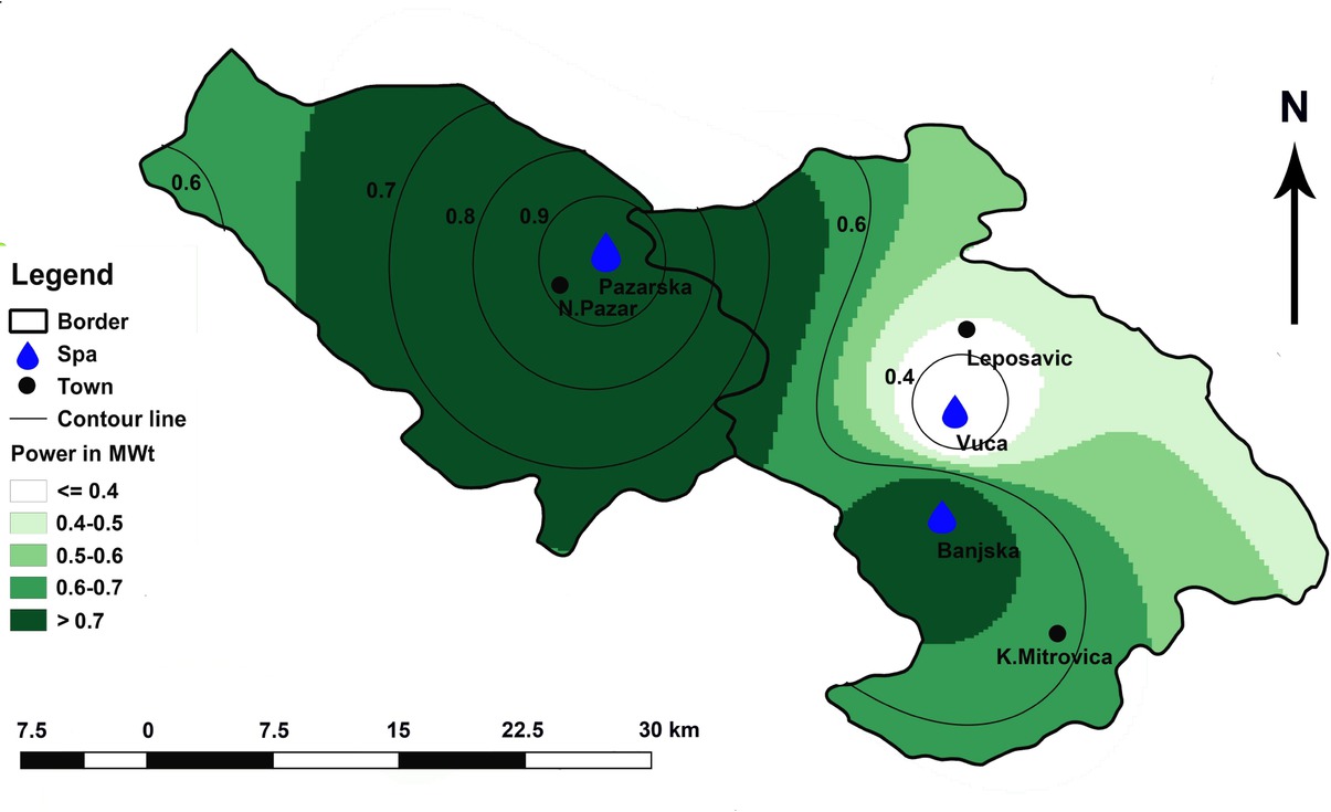
Potential installed geothermal energy in the area of three spas.
7 Possibility of valorization of hydrogeothermal energy of Rogozna Mountain
The largest energy potential (89.7 TJ/y) and the largest heat power of 2.8 MWt is displayed in Novopazarska Spa (Table 2). This is caused by the higher discharge (10 l/s) and higher temperature (52∘C), (Equation 1; Equation 2). Significantly less potential (46.2 TJ/year) and less heat power (1.5MWt) is displayed in Banjska Spa (Table 2). The least potential of all displays is in the spa of Vuča due to the least discharge and the lowest water temperature. Total hydrogeothermal potential of Mountain Rogozna is estimated to 4.6MWt for a heat power and on 145.4TJ/year for heat energy (Table 2). With the temperature of 20∘C, water could be used for recreational purposes as well as for balneology. There are no such possibilities in Vuča due to the lower temperature of water. The only possibility would be partial calefaction of the water.
Characteristics and geothermal potential of ThM springs on the territory of Rogozna mountain.
| TM springs | Flow rate (discharge) l/s | Temperature Inlet ∘C | Temperature outlet ∘C | Capacity(Eq.) (MWt) | Energy use(Eq.2) (TJ/year) |
|---|---|---|---|---|---|
| Banjska | 5 | 120 | 50 | 1.5 | 46.2 |
| Novopazarska Spa | 10 | 120 | 52 | 2.8 | 89.7 |
| Vuča | 0.8 | 120 | 30 | 0.3 | 9.5 |
| Total | 4.6 | 145.4 | |||
Again, the least possibility for balneotherapy is in Vuča spa, due to the least source discharge and limited application for other purposes (Table 3). Therefore, the highest potential is displayed in Novopazarska Spa. With only 47% of spent energy in balneotherapy, its water is still useful for heating of the existing spa resort, greenhouses, animal farms etc. (Table 3). Banjska Spa is of lesser potentials, but its thermal water could be also used in greenhouse heating, animal or fish farming. The following examples are the best to illustrate possibilities and economic effects: Heating of 1 ha of greenhouse requires 2.5TJ/year; greenhouse field of 5ha could bring annually a benefit of 2 million euros [37]; production of about 10 kg of tomatoes in greenhouse requires 25-35l of fuel oil [38]. Thus, the spare of energy and economic benefit of these spas are advantages that should be used. The use of hydrogeothermal energy from Mountain Rogozna is on its minimum in comparison with possibilities. It is still in use in traditional ways, in most cases in balneology and sport-recreation activities. Incomplete use of thermo-mineral sources in the spas of mountain Rogozna represents a great loss of energy. The free run-off of waters may cause great problems in the environment because this water flows without control in the water streams. Thermal waters in Vuča are not valorized yet and used minimally for sport-recreation activities, although they can be used for fish farming and heating in greenhouses for fruit and vegetables (Table 3). Water in Novopazarska Spa and Banjska could be used for heating in hotel and residential objects [36]. It has already been proved that Novi Pazar Spa and Banjska help to cure many diseases, primarily through bathing. Novopazarska and Banjska spas are used for medical purposes, especially Novopazarska spa. The waters of these spas are used also for treatment of rheumatic disease and sports injuries, as well as for the treatment of human musculoskeletal system, spondylosis, lumboishialgia, treatment after injury, etc. [30, 31, 3236]. The hydro-thermal energy of Rogozna could be quite efficiently used for warming and cooling by using the already existing thermal springs or by building thermal pumps. Today, there is an anomaly where, apart from this hot water, the population and the rehab centers (hotels, hospitals, care homes) use other fuels such as coal, oil etc., for the purpose of winter warming. This even raises the price of accommodation and treatment in such amenities and it is enormously detrimental to the environment. Since it concerns landscapes of an exceptional ambience value, which show the inclination of becoming an air spa (climatic healing center), the issue should be tackled quite practically, using the positive example of Niš, Vranje, Kuršumlija, Lukovska, Prolom, Mataruška, Bukovička and other spas which use their water for warming the rooms [33, 34, 35]. One should emphasize the fact that such water use would not harm the balneological function of these places. After its use in treatments and for recreational purposes, this water could be used either for warming or for cooling the rooms. Standing in the nearest proximity of these springs, there are two larger urban settlements, Kosovska Mitrovica and Novi Pazar including several smaller towns, Zubin Potok, Leposavic, and Raska. That means that a market for the goods produced in such a way is procured. Along with the minimal price of warming, there would be a decent price of the products. In these settlements there isn‘t any organized flower growing, hence this production would find a market. The waters of these spas could successfully be used in the technology of drying fruit, vegetables and forest fruits. Of course, it could all happen after the use for healing purposes, so as not to harm their balneological function. Thermal waters emerging from Mt. Rogozna are a large hydrogeothermal reservoir of approximately 200 km2, discharge 15.8 l/s, i.e., about 0.3% of total discharge summarized for all sources in Serbia. Thermal sources in Mt. Rogozna produce heat power of 4.6MWt (1.4% of heat power given by all sources in Serbia). The present political situation is that this water can be used for renewable energy, mineral and curative purposes. In the future, this energy and potential can be used and valorized much more (Table 4).
Geothermal potential of the main spas on the territory of Rogozna.
| Locality | Type | Capacity(Eq.1) (MWt) | Energy use(Eq.2) (TJ/year) | Capacity Factor (Eq.3) | kWh† | toe‡ |
|---|---|---|---|---|---|---|
| Banjska | BGF | 1.5 | 46.2 | 1 | 13.2 | 1103.5 |
| Novopazarska Spa | BGCK | 2.8 | 89.7 | 1 | 24.6 | 2142.5 |
| Vuča | B | 0.3 | 9.5 | 1 | 2.7 | 7.2 |
| Total | 4.6 | 145.4 | 1 | 40.5 | 3253.2 |
† 1 TJ = 277777.778 kWh; 1 toe = 11,630 MWh (11630 kWh)
‡ 1 TJ = 23.8845897 toe; 1 toe = 0.041868 TJ (41,868 GJ)
Properties of geothermal potential in comparison with Serbia.
| Republic of Serbia | Rogozna Mountain | |
|---|---|---|
| Investigated area (km2) | 88361 | 200 |
| Total flow rate (kg/s) | 4700 | 16.3 |
| Total heat power (MWt) | 320 | 4.6 |
| Total energy (TJ/year) | 8373.6 | 145.4 |
8 Discussion
In this research we try to explain geothermal potential of the three spas in the mountain Rogozna area. Based on the analysis of geology, geomorphology, geohydrology, geostatistics and GIS analysis the renewable potential for all three spas is found. The main energy used in the municipalities still belongs to a dirty energy or non-renewable energy sources. The energy strategy of Europe included possibilities that renewable energy sources must reach 40% before 2040 [51, 52]. In Serbia this would be between 10-20%. This ambitious plan for Serbia, especially in the sub-urban and in the areas far away from the cities may be difficult to establish. The region of Rogozna Mountain lies between northern part of Kosovo and south-west Serbia, which may cause some difficulties for the European Union in investing into renewable energy projects. Sorting out the problems with energy in developing countries, may contribute to political stability. Renewable energy will, partly or completely, substitute non-renewable in the future. Before this investigation we didn’t find any relevant or fresh data for the area of Rogozna Mountain, but plenty of authors researched the potential of geothermal energy in Serbia and region. One previous investigation in very close area of Raška estimated geothermal energy resources to 6.17 MWt per year. This energy could be used for heating the public institutions and objects in the area of spas during winter [53]. In another region in the municipality of Kuršumlija researcher found huge possibilities of geothermal power in three spas, Lukovska, Prolom and Kuršumlijska. The thermal-mineral waters can be used in curative and energy purposes. The estimated geothermal energy in the municipality of Kuršumlija is 18.8 MWt [42]. The estimated potential of renewable energy in MWt shows better values between Novopazarska spas and Banjska. In the vicinity of Banjska spa, on the area of 15.1 km2, there is a possibility of power plants reinforcement, due to the detected potential of 0.7 MWt. In the vicinity of Novopazarska spa the area which satisfies these criteria is 8.5 km2. The average elevation of this energy in the area of Novi Pazar municipality is between 350-550 m, and in Zvečan municipality it is between 500-600 m. In the touristic area of Kopoanik mountain estimated energy is 24.1 MWt. This energy could be used from 19 thermo-mineral springs and 4 spas. These spas have temperatures between 21 to 78.7∘C [54]. In general, the history of investigation of renewable energy in Serbia dates back to the ancient time. Healthy springs were known and used back in the Roman times as could be inferred from the ruins of the Roman baths and Necropolis from the 3rd and the 4th century near the spa of Vuča. Small Roman remnants were found near the Ibar river and settlement Banjska, both being very close to Vuča. The study of the genesis, chemical and physical properties of mineral and thermal-mineral waters in Serbia has been employed for more than 150 years. The first scientifically supported investigations of geothermal energy systems refer to the book”Ground Water”, which was published by Radovanović as early as in 1897 [55]. Radovanović is recognized as the pioneer of hydrogeology and geothermology, and he emphasized the unavoidable link between geology, chemistry, and medicine in his studies. Excluding Radovanović and following some established principles, a few scientists gave chemical and physical characteristics for dozens of spas in the Kingdom of Serbia, as well as in the Kingdom of Yugoslavia [56, 57]. The first detailed approach to water genesis and content of microelements in thermal waters in Serbia was given by Vujanović and Teofilović in 1983 [58]. According to some researchers the total capacity of geothermal energy in the whole territory of Serbia is estimated to about 100 MWt. In the area of Rogozna mountain this energy could reach 3 MWt. According to the results obtained by numerical GIS analyses, it should be assumed that a significant part of energy derived from geothermal resources could be used in the future for balneology, for heating of spa resorts, hotels as well as for greenhouses. Further investigations, such as underground cadaster GIS, and remote sensing may discover new sources and complete the existing data of geothermal potentials in the municipalities of Kosovska Mitrovica, Banjska and Novi Pazar. All these municipalities belong to the mountain area of Rogozna.
9 Conclusion
In terms of geothermal potential, Serbia belongs to a group of richer countries. Nonetheless, this potential is just symbolically used. The greatest number of natural flows of thermo-mineral waters is used for balneological and recreational purposes, and there is just a small number of spas that use water additionally for warming rooms or in greenhouse agriculture. One of the regions that could join these spas is the region of Rogozna Mountain. The two already formed spas, Novi Pazar Spa and Banjska Spa, including a potential one, Vuča, along with a couple of unexamined springs, are proof of the already proven balneological function and the great potential that could be used for other purposes. In this way, the effects of using waters would be enlarged; the price of healing in these centers would be lowered. We would preserve a clean and healthy environment, saving a considerable amount of means specified for the supply of other energy sources. According to expertise assessment, the inside parts of Rogozna Mountain hide even greater thermal and energetic potential. More detailed geo-physical, geochemical and other works would probably obtain a larger amount of high temperature water. If water temperatures on the surface are 52∘C in Novi Pazar Spa and 50∘C. In Banjska, and they pour out from secondary reservoirs, it is reasonable to expect the water of a considerably higher temperature from the primary reservoir. It is estimated that the primary reservoir could cover an area of even 200 km2, and that it lies at the depth of 2000 mand has a temperature of 120∘C. Such prognoses give the possibility of additional use of geothermal energy in these spas and their nearby surroundings. The geothermal potential of the Rogozna Mountain calculated where the springs emerge in the field area, equals to about 4.6MWt but the possibilities are doubtlessly greater. It shows the necessity for accessing new drill holes, for the purpose of reaching hyper-thermal water. With the support of the Government at local and national scale, we may expect more investment in the sector of renewable energy, as well as higher profit. The local government for all four municipalities in Kosovo could reach the goals set, with the support of the European Union. New budget may be helpful for reopening the old and making new sources functional, and turned into spas. However, without concrete help of the Government of the Republic of Serbia, the sector of renewable geothermal energy could not develop as predicted.
Acknowledgement
The authors are very grateful for the obtained data from Banjska spa, as well as from the municipality of Zvecan, as well as to the Serbian Ministry of Education and Science that supported this work within the project No.176019.
References
[1] Zagam Abbas, S., Kousar, A., Razzaq, S., Saeed, A., Mehboob, A., Anzar, M. (2018): Energy management in South Asia. Energy Strategy Reviews. Volume 21: 25-34. https://doi.org/10.1016/j.esr.2018.04.00410.1016/j.esr.2018.04.004Suche in Google Scholar
[2] Valent, V., Krgović, M., Kršikapa, M., Nikolić, S. (2008): Energijski potencijali u svetu i njihov značaj u celulozno-papirnoj industriji. Hem. ind. 62 (4) :223–232. doi:10.2298/HEMIND0804223V10.2298/HEMIND0804223VSuche in Google Scholar
[3] Hou, J., Cao, M., Liu, P. (2018): Development and utilization of geothermal energy in China: Current practices and future strategies. Renewable Energy 125 (2018):401-412. https://doi.org/10.1016/j.renene.2018.02.11510.1016/j.renene.2018.02.115Suche in Google Scholar
[4] Andrić, N. (2015): Geotermalna energija i mogućnost njene primene u Srbiji, Tehnika-mašinstvo 64,5:804-808.Suche in Google Scholar
[5] Liber Perpetuum, OSCE, (2004): Mission to Serbia and Montenegro, Economic and Environmental department, Belgrade.Suche in Google Scholar
[6] Golusin, M., Munitlak Ivanović, O., Bagarić, I., Vranješ, S. (2010): Exploitation of geothermal energy as a priority of sustainable energetic development in Serbia. Renewable and Sustainable Energy Reviews 14(2): 868-871. https://doi.org/10.1016/j.rser.2009.06.02610.1016/j.rser.2009.06.026Suche in Google Scholar
[7] Falcone, G., Liu, X., Radido Okech, R., Seyidov, F., Teodoriu, C. (2018): Assessment of deep geothermal energy exploitation methods: The need for novel single-well solutions. Energy 160 (2018) 54-63. https://doi.org/10.1016/j.energy.2018.06.14410.1016/j.energy.2018.06.144Suche in Google Scholar
[8] Prada, M. F., Brata, S., Tudor, D. F., Popesku, D. E. (2013): Aspects of Reducing of Gas Emissions according to the EU Energy Policy Targets. Journal of Environmental Protection and Ecology, 14 (1), 209.Suche in Google Scholar
[9] Prada, M., Popesku, D. E., Bungau, C., Pancu, R., Bungau, C. (2017): Parametric Studies on European 20-20-20 Energy Policy Targets in University Environment. Journal of Environmental Protection and Ecology, 18 (3): 1146-1157.Suche in Google Scholar
[10] Cvetanović, S., Jovanović, M. (2014): Mesto obnovljivih izvora i energetske efikasnosti u energetskoj politici EU. Ekonomika, 60(1): 41-49.Suche in Google Scholar
[11] Apak, S., Acikoz, A. F. (2011): Renewable Energy Zones (REZs) as a Strategic Alternative with Environmental and Economic Aspects of Sustainability. The Case of Balkans. Journal of Environmental Protection and Ecology, 12 (4):1860-1865. http://www.jepe-journal.info/vol12-no4aSuche in Google Scholar
[12] Milivojević, M., Martinović, M. (2005): Geothermal energy possibilities, exploration and future prospects in Serbia. In: Proceedings of the world geothermal congress 2005. Antalya, Turkey.Suche in Google Scholar
[13] Milenić, D., Milivojević, M., Krunić, O., Vranješ, A. (2014): Hidrogeotermalni resursi kao faktor razvoja Srbije: Srpska akademija nauka i umetnosti-Odbor za selo, Lukovska banja, Srbija, 2014. (in Serbian). file:///D:/2014GeoTerVode3VRANES.pdfSuche in Google Scholar
[14] Krunić, O., Lazić, M., Dokmanović, P., Dragišić, V., Polomčić, D. (2014): Ocena iskorišćenosti termalnih i lekovitih voda u banjama Srbije: Okrugli sto, SANU, Lukovska banja, Srbija, 2014 (in Serbian);Suche in Google Scholar
[15] Oudech, S., Ðokić, I. (2015): Geothermal Energy Use, Country Update for Serbia, Proceedings World Geothermal Congress 2015 Melbourne, Australia.Suche in Google Scholar
[16] Ministry of Energy, Development and Environmental Protection, Republic of Serbia (2013). National Renewable Energy Action Plan of the Republic of Serbia. Belgrade: Republic of Serbija. Available at: http://www.mre.gov.rs/doc/efikasnostizvori/NREAP%20OF%20REPUBLIC%20OF%20SERBIA%2028_June_2013.pdf (accessed 21 January 2018).Suche in Google Scholar
[17] Joksimović, M., Pavlović, M. A. (2014): Conditions and possibilities of direct utilisation of thermal-mineral waters in Raska region, Serbia. Renewable and Sustainable Energy Reviews, 32: 107–113 https://doi.org/10.1016/j.rser.2013.12.04810.1016/j.rser.2013.12.048Suche in Google Scholar
[18] Stojanović, M. (2009): Priroda Ibarskog Kolašina, Zbornik radova, Centar za naučna istraživanja SANU i Univerziteta u Kragujevcu: 15-78.Suche in Google Scholar
[19] Tomović, G. (2007): Kosovo and Metohija on old maps from the XV to the XVIII century, Source: Kosovo and Metohija- past, present, future, Papers presented at the Internacional Scholarly Meeting held at the Serbian Academy of Science and Arts, Belgrade: 49-60.Suche in Google Scholar
[20] Borojevic-Sostaric Sibila, Palinkas, L.A., Neubauer, F., Hurai, V., Cvetkovic Vladica D., Roller-Lutz, Z., Mandolic, M., Genser, J. (2013): Silver-base metal epithermal veir and listwanit hosted deposit Crnac, Rogozna Mts. Kosovo, part II A link between magmatic rocks and epithermal mineralization. Ore Geology Reviews, 50: 97-117. https://doi.org/10.1016/j.oregeorev.2012.10.00510.1016/j.oregeorev.2012.10.005Suche in Google Scholar
[21] Robertson, A.H.F., Karamata, S. & Šarić, K. (2009): Overview of ophiolites and related units in the Late Palaeozoic–Early Cenozoic magmatic and tectonic development of Tethys in the northern part of the Balkan region. Lithos, 108, 1–4, 1–36. https://doi.org/10.1016/j.lithos.2008.09.00710.1016/j.lithos.2008.09.007Suche in Google Scholar
[22] Borojević Šoštarić, S., Cvetković, V., Neubauer, F., Palinkaš, L.A., Bernroider, M., Genser, J. (2012). Oligocene shoshonitic rocks of the Rogozna Mts. (Central Balkan Peninsula): Evidence of petrogenetic links to the formation of Pb–Zn–Ag ore deposits. Lithos 148: 176–195. https://doi.org/10.1016/j.lithos.2012.05.02810.1016/j.lithos.2012.05.028Suche in Google Scholar
[23] Srećković-Batoćanin, D., Memović, E., Cvetković, V. (1992):Piroklastični tokovi područja Brezanske glavice, Novi Pazar, Srbija. Geološki anali Balkanskog poluostrva 55(1):359-374. Doi: 10.2298/GABP9256359S10.2298/GABP9256359SSuche in Google Scholar
[24] Filipović, B. (2003): Mineralne, termalne i termomineralne vode Srbije. Rudarsko-geološki fakultet, Beograd.Suche in Google Scholar
[25] Tanasković, I., Golobočanin, D., Miljević, N. (2012): Multivariate statistical analysis of hydrochemical and radiological data of Serbian spa waters. Journal of Geochemical Exploration 112: 226–234. https://doi.org./10.1016/j.gexplo.2011.08.01410.1016/j.gexplo.2011.08.014Suche in Google Scholar
[26] Protić, D. (1995): Mineralne i termalne vode Srbije. Geoinstitut, Posebna izdanja, knjiga 17: 65-67.Suche in Google Scholar
[27] Bil, M., Bilova, M., Kubeček, J. (2012): Unified GIS database on cycle tourism infrastructure. Tourism Menagenent 33 (6): 1554-1561. https://doi.org./10.1016/j.tourman.2012.03.002Suche in Google Scholar
[28] Valjarević, A., Živković, D., Valjarević, D., Stevanović, V., Golijanin, J. (2014): GIS Analysis of Land Cover Changes on the Territory of the Prokuplje Municipality. The Scientific World Journal Volume 2014, 1-8. https:/dx.doi.org/10.1155/2014/80507210.1155/2014/805072Suche in Google Scholar PubMed PubMed Central
[29] Valjarević, A., Djekić, T., Stevanović, V., Ivanović, R., Jandziković, B. (2018): GIS numerical and remote sensing analyses of forest changes in the Toplica region for the period of 1953-2013. Applied Geography, 92: 131-139. https://doi.org./10.1016/j.apgeog.2018.01.01610.1016/j.apgeog.2018.01.016Suche in Google Scholar
[30] Plojović, Š., Bećirović, S., Šaćirović, S., Ujkanović, E. (2010): Mogućnost razvoja banjskog turizma u novopazarskom kraju, Univerzitetska Hronika. 3,(1) :119- 128. DOI: 10.13140/2.1.2217.856610.13140/2.1.2217.8566Suche in Google Scholar
[31] Milentijević, G., Nedeljković, B. (2010): Termomineralne vode Banjske, potencijalnost, kvalitet, mogućnost korišćenja. Rudarski radovi 1, 147-158. https://irmbor.co.rs/casopis/casopis-rudarski-radovi/Suche in Google Scholar
[32] Rezultati senzorskih, fizičkih i hemijskih ispitivanja uzoraka banje Vuča (2007): Institut za javno zdravlje “Dr Milan Jovanovic Batut “ Beograd.Suche in Google Scholar
[33] Dokmanović, P., Krunić, O., Martinović, M., Magazinović, S. (2012): Hidrogeothermal Resource in Spa Areas of Serbia. Thermal Science, 16(1): 21-30. DOI: 10.2298/TSCI1201021D10.2298/TSCI1201021DSuche in Google Scholar
[34] Riznić, D., Kovačić, B. (2012): Water temperature adjustment in spas by the aid of Heat Pumps, Thermal Science. 16(4): 1127-1136. DOI: 10.2298/TSCI1204127R10.2298/TSCI1204127RSuche in Google Scholar
[35] Stojiljkovic, D., Stojiljkovic, S., Mitic, V., Pejic, D., Djurovic-Petrovic, M. (2006): Pilot Plant for Explitation of Geothermal Waters. Thermal Science 10(4): 195-203. https://doi.org./10.2298/TSCI0604195S10.2298/TSCI0604195SSuche in Google Scholar
[36] Nikolić, V., Nikolić S., Milivojević, S., Milisavljević S. (2003): Karakteristike geotermalnih voda Banjske, Ecologica 13:119-122.Suche in Google Scholar
[37] Gajić, M., Vujadinović, S. (2005): Nalazista i mogućnosti korišćenja termalnih voda u Debrcu, Glasnik SGD LXXXV-1: 57-62. https://doi.org/10.2298/GSGD0501057G10.2298/GSGD0501057GSuche in Google Scholar
[38] Lekić,S., Pešić, V.(1996): Korišćenje geotermalnih voda u poljoprivredi, Ekologika br.3.Suche in Google Scholar
[39] Lučić, S., Antonijević, D.(2011): Održivo korišćenje energetskog potencijala podzemnih voda pomoću toplotnih pumpi, Ecologica, 18: 221-224.Suche in Google Scholar
[40] Ðorđević, B. (2008): Objektivno vrednovanje obnovljivih energija, Vodoprivreda 40:19-38. http://www.vodoprivreda.net/objektivno-vrednovanje-obnovljivih-energija/Suche in Google Scholar
[41] Ðereg, N., Kalmar, Z., Jovic, K., Ionut, A.(2008): Obnovljivi izvori energije u Srbiji, Centar za ekologiju i održivi razvoj CEKOR, Subotica.Suche in Google Scholar
[42] Valjarević, A.,Srećković-Batoćanin, D., Valjarević, D., Matović V. A. (2018): GIS-based method foranalysis of a better utilization of thermal-mineral springs in the municipality of Kursumlija (Serbia). Renewable and Sustainable Energy Reviews, 92, 948-957. https://doi.org/10.1016/j.rser.2018.05.00510.1016/j.rser.2018.05.005Suche in Google Scholar
[43] Gudmundsson, J. S.; Freeston, D. H. and P. J. Lienau, (1985): The Lindal Diagram, International Symposium on Geothermal Energy, Geothermal Resources Council Transaction, 9 Part I: 15-19. https://www.geothermallibrary.org/index.php?mode=pubs&action=view&record=1001233Suche in Google Scholar
[44] Taya Terra Geo Corp. & Geothermal Managenent Company Inc. for Geoscience BC Raport 2016-07, Section B, Roadmap for development of geothermal direct-use projects in British Columbia, Canada. file:///D:/GBC%20Report%202016-07_Section%20B_Roadmap.pdfSuche in Google Scholar
[45] Hyungsil Moon and Sadiq J. Zarrouk(2014): Efficiency of geothermal power plants: A worldwide review. Geothermics, 51, 142-153. http://dx.doi.org/10.1016/j.geothermics.2013.11.00110.1016/j.geothermics.2013.11.001Suche in Google Scholar
[46] OliveraEćim-Ðurić, Tomić V., Milanović P. (2008): Energetska optimizacija sistema za korišćenje geotermalne energije za grejanje plastenika. Poljoprivredna tehnika, 3: 49-55. http://www.jageng.agrif.bg.ac.rs/files/casopis/PT_03-2008.pdfSuche in Google Scholar
[47] http://www.energyobserver.comSuche in Google Scholar
[48] Zarrouk, S.J. (2011): Geothermal energy technology Lecture, University of Auckland.Suche in Google Scholar
[49] Lund,J.W., Freeston, D.H., Boyd, T.L. (2005): Direct Apllication of Geothermal Energy, Geothermics, 34 (6):691-727. doi:10.1016/j.geothermics.2005.09.00310.1016/j.geothermics.2005.09.003Suche in Google Scholar
[50] Ivic, M., Andrin, O., Jorovic, B. (2002): Resursi geotermalne energije u Srbiji i mogucnost koriscenja, 3-4, 92-96.Suche in Google Scholar
[51] UNDP. World energy assessment (2000): energy and the challenge of sustainability. New York: UNDP (ISBN 9211261260).Suche in Google Scholar
[52] Dincer, I. (2010): Environmental issues II. Potential solutions. Energy Sources, Part A:Recovery, Utilization of Environment Efficiency, 23:83–92. https://doi.org./10.1080/0090831015109221810.1080/00908310151092218Suche in Google Scholar
[53] Joksimović, M., Pavlović, AM. (2014):Conditions and possibilities of direct utilisation of thermal-mineral waters in Raska region, Serbia. Renewable and Sustainable Energy Reviews, 32:107–13. http://dx.doi.org/10.1016/j.rser.2013.12.04810.1016/j.rser.2013.12.048Suche in Google Scholar
[54] Ristić, D.,Vukoičić, D., Nikolić, M., Milinčić, M., Kićović, D. (2019): Capacities and energy potential of thermal-mineral springs in the area of the Kopaonik tourist region (Serbia). Renewable and Sustainable Energy Reviews, 102: 129-138. Doi: https://doi.org/10.1016/j.rser.2018.12.00510.1016/j.rser.2018.12.005Suche in Google Scholar
[55] Radovanović,S. (1897): Ground Waters: aquifers, springs, wells, thermal and mineral waters 42. Belgrade: Serbian Books Assosiation, p. 152.Suche in Google Scholar
[56] Lindenmayer, E. (1856): Opis Mineralnih i lekovitih voda, Beograd.Suche in Google Scholar
[57] Leko, AM., Šerbakov, A., Joksimović. H. (1922): Lekovite vode i klimatska mesta Kraljevine Srba, Hrvata i Slovenaca, Ministarstvo narodnog zdravlja, Beograd.Suche in Google Scholar
[58] Teofilović, M.. Vujanović, A., Arsenijević, S. (1971): Sadržaji elemenata u termomineralnoj vodi Banje Koviljače. Zapasnici Srpskog geološkog društva za Beograd.Suche in Google Scholar
[59] Wałowski, G. (2018). Experimental Assessment of Porous Material Anisotropy and its Effect on Gas Permeability. Civil Ingineering Journal, 4(4): 906-915. doi:10.28991/cej-0309143.10.28991/cej-0309143Suche in Google Scholar
[60] Ekeleme, A. C., & Agunwamba, J. C. (2018). Experimental determination of dispersion coefficient in soil. Emerging Sciece Journal, 2(4):213-215. doi:10.28991/esj-2018-01145.10.28991/esj-2018-01145Suche in Google Scholar
[61] Junian, J., Azizifar, V. (2018). The Evaluation of Temporary Shelter Areas Locations Using Geographic Information System and Analytic Hierarchy Process. Emergency Science Journal, 4(7): 1678-1788.doi:10.28991/cej-03091104.10.28991/cej-03091104Suche in Google Scholar
[62] Forcellini, D., Tanganelli, M., Viti, S. (2018). Response site analyses of 3D homogeneous soil models. Emergency Science Journal, 2(5): 238-250. doi:10.28991/esj-2018-01148.10.28991/esj-2018-01148Suche in Google Scholar
[63] Kandissounon, G. A., Kalra, A., Ahmad, S. (2018). Integrating System Dynamics and Remote Sensing to Estimate Future Water Usage and Average Surface Runoff in Lagos, Nigeria. Civil Ingineering Journal, 4(2): 378-293 doi:10.28991/cej-030998.10.28991/cej-030998Suche in Google Scholar
[64] Karamata, S. (2006). The geological development of the Balkan Peninsula related to the approach, collision and compression of Gondwanan and Eurasian units. In: Robertson, A.H.F., Mountrakis, D. (Eds.), Tectonic Development of the Eastern Mediterranean Region. Geological Society, London, Special Publications, 260: 155–178. https://doi.org/10.1144/GSL.SP.2006.260.01.0710.1144/GSL.SP.2006.260.01.07Suche in Google Scholar
[65] Urošević, M., Pavlović, Z., Klisić, M., Karamata, S., Malešević, M., Stefanović, M., Marković, O., Trifunović, S., 1966/73. Basic Geological Map 1:100,000, sheet Novi Pazar. Explanatory note. Federal Geological Institute, Belgrade, 77 pp.Suche in Google Scholar
[66] Borojević-Šoštarić, S., Palinkaš, L.A., Neubauer, F., Hurai, V., Cvetković, V., Roller-Lutz, M., Mandić,M., Genser, J. (2013). Silver-base metal epithermal vein and listwanite hosted deposit Crnac, Rogozna Mts., Kosovo, part II: A link between magmatic rocks and epithermal mineralization. Ore Geological Journal, 50:98-117. https://doi.org/10.1016/j.oregeorev.2012.10.00510.1016/j.oregeorev.2012.10.005Suche in Google Scholar
© 2019 D. R. Ivanović et al., published by De Gruyter
This work is licensed under the Creative Commons Attribution 4.0 Public License.
Artikel in diesem Heft
- Regular Articles
- 2D Seismic Interpretation of the Meyal Area, Northern Potwar Deform Zone, Potwar Basin, Pakistan
- A new method of lithologic identification and distribution characteristics of fine - grained sediments: A case study in southwest of Ordos Basin, China
- Modified Gompertz sigmoidal model removing fine-ending of grain-size distribution
- Diagenesis and its influence on reservoir quality and oil-water relative permeability: A case study in the Yanchang Formation Chang 8 tight sandstone oil reservoir, Ordos Basin, China
- Evaluation of AHRS algorithms for Foot-Mounted Inertial-based Indoor Navigation Systems
- Identification and evaluation of land use vulnerability in a coal mining area under the coupled human-environment
- Hydrocarbon Generation Potential of Chia Gara Formation in Three Selected Wells, Northern Iraq
- Source Analysis of Silicon and Uranium in uranium-rich shale in the Xiuwu Basin, Southern China
- Lithologic heterogeneity of lacustrine shale and its geological significance for shale hydrocarbon-a case study of Zhangjiatan Shale
- Characterization of soil permeability in the former Lake Texcoco, Mexico
- Detrital zircon trace elements from the Mesozoic Jiyuan Basin, central China and its implication on tectonic transition of the Qinling Orogenic Belt
- Turkey OpenStreetMap Dataset - Spatial Analysis of Development and Growth Proxies
- Morphological Changes of the Lower Ping and Chao Phraya Rivers, North and Central Thailand: Flood and Coastal Equilibrium Analyses
- Landscape Transformations in Rapidly Developing Peri-urban Areas of Accra, Ghana: Results of 30 years
- Division of shale sequences and prediction of the favorable shale gas intervals: an example of the Lower Cambrian of Yangtze Region in Xiuwu Basin
- Fractal characteristics of nanopores in lacustrine shales of the Triassic Yanchang Formation, Ordos Basin, NW China
- Selected components of geological structures and numerical modelling of slope stability
- Spatial data quality and uncertainty publication patterns and trends by bibliometric analysis
- Application of microstructure classification for the assessment of the variability of geological-engineering and pore space properties in clay soils
- Shear failure modes and AE characteristics of sandstone and marble fractures
- Ice Age theory: a correspondence between Milutin Milanković and Vojislav Mišković
- Are Serbian tourists worried? The effect of psychological factors on tourists’ behavior based on the perceived risk
- Real-Time Map Matching: A New Algorithm Integrating Spatio-Temporal Proximity and Improved Weighted Circle
- Characteristics and hysteresis of saturated-unsaturated seepage of soil landslides in the Three Gorges Reservoir Area, China
- Petrographical and geophysical investigation of the Ecca Group between Fort Beaufort and Grahamstown, in the Eastern Cape Province, South Africa
- Ecological risk assessment of geohazards in Natural World Heritage Sites: an empirical analysis of Bogda, Tianshan
- Integrated Subsurface Temperature Modeling beneath Mt. Lawu and Mt. Muriah in The Northeast Java Basin, Indonesia
- Go social for your own safety! Review of social networks use on natural disasters – case studies from worldwide
- Forestry Aridity Index in Vojvodina, North Serbia
- Natural Disasters vs Hotel Industry Resilience: An Exploratory Study among Hotel Managers from Europe
- Using Monarch Butterfly Optimization to Solve the Emergency Vehicle Routing Problem with Relief Materials in Sudden Disasters
- Potential influence of meteorological variables on forest fire risk in Serbia during the period 2000-2017
- Controlling factors on the geochemistry of Al-Shuaiba and Al-Mejarma coastal lagoons, Red Sea, Saudi Arabia
- The Influence of Kaolinite - Illite toward mechanical properties of Claystone
- Two critical books in the history of loess investigation: ‘Charakteristik der Felsarten’ by Karl Caesar von Leonhard and ‘Principles of Geology’ by Charles Lyell
- The Mechanism and Control Technology of Strong Strata Behavior in Extra-Thick Coal Seam Mining Influenced by Overlying Coal Pillar
- Shared Aerial Drone Videos — Prospects and Problems for Volunteered Geographic Information Research
- Stable isotopes of C and H in methane fermentation of agriculture substrates at different temperature conditions
- Prediction of Compression and Swelling Index Parameters of Quaternary Sediments from Index Tests at Mersin District
- Detection of old scattered windthrow using low cost resources. The case of Storm Xynthia in the Vosges Mountains, 28 February 2010
- Remediation of Copper and Zinc from wastewater by modified clay in Asir region southwest of Saudi Arabia
- Sedimentary facies of Paleogene lacustrine dolomicrite and implications for petroleum reservoirs in the southern Qianjiang Depression, China
- Correlation between ore particle flow pattern and velocity field through multiple drawpoints under the influence of a flexible barrier
- Atmospheric refractivity estimation from AIS signal power using the quantum-behaved particle swarm optimization algorithm
- A geophysical and hydro physico-chemical study of the contaminant impact of a solid waste landfill (swl) in King Williams’ Town, Eastern Cape, South Africa
- Landscape characterization using photographs from crowdsourced platforms: content analysis of social media photographs
- A Study on Transient Electromagnetic Interpretation Method Based on the Seismic Wave Impedance Inversion Model
- Stratigraphy of Architectural Elements of a Buried Monogenetic Volcanic System
- Variable secondary porosity modeling of carbonate rocks based on μ-CT images
- Traditional versus modern settlement on torrential alluvial fans considering the danger of debris flows: a case study of the Upper Sava Valley (NW Slovenia)
- The Influence of Gangue Particle size and Gangue Feeding Rate on Safety and Service Life of the Suspended Buffer’s Spring
- Research on the Transition Section Length of the Mixed Workface Using Gangue Backfilling Method and Caving Method
- Rainfall erosivity and extreme precipitation in the Pannonian basin
- Structure of the Sediment and Crust in the Northeast North China Craton from Improved Sequential H-k Stacking Method
- Planning Activities Improvements Responding Local Interests Change through Participatory Approach
- GIS-based landslide susceptibility mapping using bivariate statistical methods in North-western Tunisia
- Uncertainty based multi-step seismic analysis for near-surface imaging
- Deformation monitoring and prediction for residential areas in the Panji mining area based on an InSAR time series analysis and the GM-SVR model
- Statistical and expert-based landslide susceptibility modeling on a national scale applied to North Macedonia
- Natural hazards and their impact on rural settlements in NE Romania – A cartographical approach
- Rock fracture initiation and propagation by mechanical and hydraulic impact
- Influence of Rapid Transit on Accessibility Pattern and Economic Linkage at Urban Agglomeration Scale in China
- Near Infrared Spectroscopic Study of Trioctahedral Chlorites and Its Remote Sensing Application
- Problems with collapsible soils: Particle types and inter-particle bonding
- Unification of data from various seismic catalogues to study seismic activity in the Carpathians Mountain arc
- Quality assessment of DEM derived from topographic maps for geomorphometric purposes
- Remote Sensing Monitoring of Soil Moisture in the Daliuta Coal Mine Based on SPOT 5/6 and Worldview-2
- Utilizing Maximum Entropy Spectral Analysis (MESA) to identify Milankovitch cycles in Lower Member of Miocene Zhujiang Formation in north slope of Baiyun Sag, Pearl River Mouth Basin, South China Sea
- Stability Analysis of a Slurry Trench in Cohesive-Frictional Soils
- Integrating Landsat 7 and 8 data to improve basalt formation classification: A case study at Buon Ma Thuot region, Central Highland, Vietnam
- Assessment of the hydrocarbon potentiality of the Late Jurassic formations of NW Iraq: A case study based on TOC and Rock-Eval pyrolysis in selected oil-wells
- Rare earth element geochemistry of sediments from the southern Okinawa Trough since 3 ka: Implications for river-sea processes and sediment source
- Effect of gas adsorption-induced pore radius and effective stress on shale gas permeability in slip flow: New Insights
- Development of the Narva-Jõesuu beach, mineral composition of beach deposits and destruction of the pier, southeastern coast of the Gulf of Finland
- Selecting fracturing interval for the exploitation of tight oil reservoirs from logs: a case study
- A comprehensive scheme for lithological mapping using Sentinel-2A and ASTER GDEM in weathered and vegetated coastal zone, Southern China
- Sedimentary model of K-Successions Sandstones in H21 Area of Huizhou Depression, Pearl River Mouth Basin, South China Sea
- A non-uniform dip slip formula to calculate the coseismic deformation: Case study of Tohoku Mw9.0 Earthquake
- Decision trees in environmental justice research — a case study on the floods of 2001 and 2010 in Hungary
- The Impacts of Climate Change on Maximum Daily Discharge in the Payab Jamash Watershed, Iran
- Mass tourism in protected areas – underestimated threat? Polish National Parks case study
- Decadal variations of total organic carbon production in the inner-shelf of the South China Sea and East China Sea
- Hydrogeothermal potentials of Rogozna mountain and possibility of their valorization
- Postglacial talus slope development imaged by the ERT method: comparison of slopes from SW Spitsbergen, Norway and Tatra Mountains, Poland
- Seismotectonics of Malatya Fault, Eastern Turkey
- Investigating of soil features and landslide risk in Western-Atakent (İstanbul) using resistivity, MASW, Microtremor and boreholes methods
- Assessment of Aquifer Vulnerability Using Integrated Geophysical Approach in Weathered Terrains of South China
- An integrated analysis of mineralogical and microstructural characteristics and petrophysical properties of carbonate rocks in the lower Indus Basin, Pakistan
- Applicability of Hydrological Models for Flash Flood Simulation in Small Catchments of Hilly Area in China
- Heterogeneity analysis of shale reservoir based on multi-stage pumping data