Influence of Rapid Transit on Accessibility Pattern and Economic Linkage at Urban Agglomeration Scale in China
-
Wuyang Hong
 und
Mo Su
und
Mo Su

Abstract
The development of high-speed railways has become an important factor influencing regional pattern changes in China. In this study, an accessibility evaluation model was constructed in combination with regional scale and regional center city to research the effect of high-speed rails on accessibility in the South Jiangsu, an urban agglomeration in China. Based on accessibility index, urban economic and social statistics data were used in conjunction with a gravity model to analyze the characteristics and evolvement of economic relations in this area. The result shows that high-speed rails improve overall regional accessibility, significantly benefit regions along rail lines, and makes middle- and long-distance journeys more convenient for the general public. High-speed rails play a particularly dominant role in the evolution of economic linkage and effectively strengthen the ties between cities. When the bonds between cities along rail lines greatly improve, a basic framework of economic relations is formed. Finally this paper discusses the imbalance arising from the effect of high-speed rails, proposing such suggestions as improving urban traffic and building expressways that connect high-speed rail stations in marginal areas to improve accessibility.
1 Introduction
The large-scale implementation of High-Speed Rail (HSR) network in China is currently changing accessibility to cities along the HSR line. Accessibility is a classic topic and a widely-used concept in studies of various transportation infrastructures and modes, including that of HSR, and as such, it is an index that evaluates transportation networks and traffic locations. Scholars have conducted numerous studies on the effects of HSR since the first one went into operation in Japan in 1964. One of the dominant issues in those studies is that of the influence/impact of HSR. Scholars focus their studies on space block, space effect, and chance opportunity accumulation to build accessibility models [1], as they contend that HSR improves accessibility to node cities and produces a space reconstruction effect by connecting cities and regions, having maximum impact on a large-scale [2]. Research on the Japanese Shinkansen [3], the French TGV [4], and the German ICE HSR [5] demonstrates that HSR significantly improves regional traffic conditions and greatly satisfies the demands of current and potential travel. HSR causes a mass-scale space-time contraction effect that promotes human mobility and gradually increases regional accessibility [6], significantly impacting regional interactions, urban economic development, and the evolution of the regional landscape [7].
The Chinese HSR is a latecomer relative to other countries [8]. There have been several studies of HSR in China [9], with domestic research dating back to 1994 when Qi [10], among other studies, presented qualitative discussions regarding the predictive effects on the economy and the environment with respect to noise when constructing HSR. Jiang et al. [11] conducted a case study of the Shanghai-Nanjing HSR, while Zhou and Yu [12] studied the Beijing-Guangzhou and Beijing-Shanghai lines. These studies researched the influence mechanism produced by HSR on the accessibility spatial pattern and analyzed the effect of changes in accessibility on variables of interest to urban economists. Methodologically, the geometric grid method and topological method were universally adopted. For instance, a timetable-based accessibility evaluation index including travel time, travel cost, and distance, was constructed to analyze the impact on railroad network accessibility of HSR [13].
Strengthening traffic accessibility has its most direct impact on regional development. The European Union, Japan, America, and China support HSR services because of their economic, environmental, and quality-of-life benefits [14]. By the end of 2014, China’s total HSR operating mileage exceeded 16,000 kilometers—approximately 50% of all HSR operating miles worldwide—elevating China to number one with respect to HSR miles. Such success has given rise to increased diplomacy to promote the expansion of China’s HSR to neighboring countries in southeast and central Asia. The development of HSR has been one of the central features of China’s transport infrastructure policy, especially in economically developed areas. South Jiangsu, typical urban agglomeration in China, has entered the era of high-speed rail and become the epitome of rapid development of HSR. It is appropriate to conduct research on the effects of HSR. By establishing road traffic databases for 2007 and 2013 and employing a GIS software package as basic support, this study proposes an accessibility evaluation model, operated on the mesoscale and macro-scale, and uses a gravity model to determine the economic link intensity between cities in South Jiangsu.
2 Study Area and Data Sources
2.1 Overview of the Study Area
South Jiangsu is one of the highest economically developed areas in China, reporting one of the highest GDP per capita rates in the country. It is located in the southern part of Jiangsu Province, in the core area of the economically developed Yangtze River delta which is one of six large world-class city clusters. South Jiangsu comprises Nanjing, Suzhou, Wuxi, Changzhou, and Zhenjiang. The urbanization level of South Jiangsu has surpassed 70%, which means that more than 70% of the population lives in urban areas. The per capita GDP reached 16,000 dollars in 2013, which approaches that of the level of developed countries. In the beginning of 2008, the Beijing-Shanghai HSR and the Shanghai-Nanjing HSR were under construction, while construction began in December 2008 on the Nanjing-Hangzhou and Nanjing-Anhui Intercity Railways (see Figure 1).
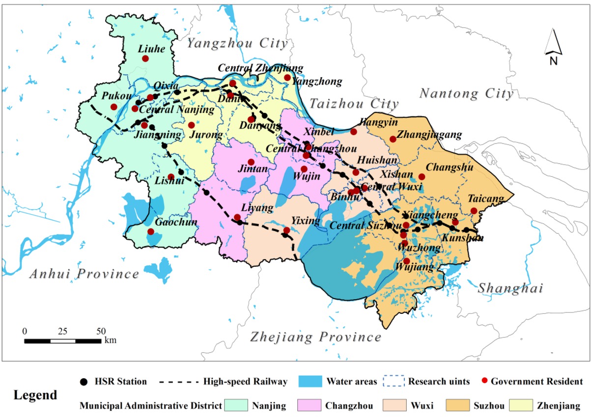
HSR network in South Jiangsu
2.2 Data Sources
High-speed and traditional railways as well as the highway were selected as the essential data sources for the evaluation of accessibility. HSR transportation extends access to areas previously available by traditional railway and roads. The data for the railways include data from lines that had opened prior to the time of the evaluation and data from lines that had already established stops in South Jiangsu. HSR data include the Beijing-Shanghai line and the Shanghai-Nanjing and Nanjing-Hangzhou Intercity Railways. Traditional railway data include the Nanjing-Wuhu Railway, the Nanjing-Qidong Railway, and the Shanghai-Nanjing section of the Beijing-Shanghai Railway. Roadway data are obtained from the Earth System Science Data Sharing Platform.
China’s administrative system is divided into four levels: provincial, prefectural, county and township. The county-level administrative region as the statistical unit of the China’s GDP, population, industry and other economic and social statistical data plays a connecting role in the entire administrative division system. Therefore, this paper chooses county administrative region as the research unit. All the administrative units are abstracted as spatial nodes, and there are 31 county-level research nodes in total (as shown in Figure 1).
3 Method
3.1 Accessibility Model
Accessibility is a fundamental concept in transportation research and planning [15, 16]. It is defined and explained in several ways; such well-known definitions are: ‘the potential of opportunities for interaction’ [17] and ‘the ease with which activities may be reached from a given location using a particular transportation system’ [18]. Yet, most calculated accessibility indices are not panaceas that can measure every aspect of accessibility [19, 20]. As the most basic method of accessibility evaluation, distance measure is generally converted to time cost for direct analysis. In this study, an accessibility model was built from a regional and metropolitan point of view. At the regional level, accessibility refers to the time cost of travel between two urban nodes (with the vector-raster analysis method, accessibility is expressed as the average of the spatial distance, time distance, and economic distance); at the central city level, accessibility refers to the time cost of travel from each urban node to a specified metropolis (with the cost-weighted raster algorithm, accessibility is expressed as the time distance).
3.1.1 Accessibility Model at Regional Scale
Spatial distance accessibility
To construct a vector-based road network dataset, the closest facility analysis method is used to seek n-1 shortest paths from the administrative station of a research unit to other administrative stations. By converting the shortest path to the required time cost (the set driving speed is listed in Table 1), the spatial distance-based accessibility of the urban node may be expressed as the average obtained, which is calculated as:
Relative time cost of different types of grids
| Types | Design speed (km/h) | Running speed (km/h) | Time costs (min) | Types | Design speed (km/h) | Running speed (km/h) | Time costs (min) |
|---|---|---|---|---|---|---|---|
| HSR | 350 | 200 | 3 | Third-class road | 30 | 25 | 24 |
| Traditional railway | – | 150 | 4 | Fourth-class road | – | 20 | 30 |
| Expressway | 120 | 100 | 6 | Land without road | – | 15 | 40 |
| First-class road | 100 | 75 | 8 | Water area | – | – | 600 |
| Second-class road | 60 | 50 | 12 | No data | – | – | – |
where, Li refers to the spatial distance-based accessibility of urban node i, lij refers to the shortest distance between two nodes, and n refers to the number of nodes.
Temporal distance accessibility
By calculating the shortest weighted distance from each grid to a destination with the shortest path algorithm based on raster data, we may obtain the time-based accessibility. The ArcGIS ‘Cost Distance’, a spatial analysis tool, is efficient in measuring the least accumulative cost for each cell to the nearest source based on raster datasets [21]. Using a cost raster graph, along with data from the administrative stations of research units, a layer of the shortest time distance from each raster to a destination is obtained through the cost distance weighted function, following which the raster costs of other administrative stations are extracted and averaged to express the time distance-based accessibility of the destination.
Building a cost raster graph is important for the model of time distance-based accessibility. The study area was divided into regular raster grid cells with a spatial resolution of 50 m × 50 m, and each cell was assigned a related time cost as an attribute. Based on the speed determined by previous studies [22, 23], combined with actual transportation data from South Jiangsu, the velocities of each cell are shown in the following table.
Economic distance accessibility
Economic distance-based accessibility refers to the time cost required for the route along which the minimum cost is incurred. Through inquiry of the railway timetable and long-distance bus timetable, the fare for each public transport line in South Jiangsu and the corresponding road mileage are obtained. The fare index is defined as the average fee per unit of road mileage and is calculated as follows:
where I refers to the fare index, Pi refers to the fare of the ith sample in the event of travel by means of transportation, Si refers to the corresponding distance, and n refers to the number of samples. To estimate the fare, only public transportation by passenger is considered, excluding travel by private car, freight, bike, and foot. The price difference arising from vehicle conditions is ignored, and the fare of a hard seat or second-class seat is considered in the event of travel by rail.
Through construction of a vector-based traffic network dataset, values are assigned to the fares of different means of transport (as shown in Table 2). The GIS-based closest facility analysis method is used to seek n-1 paths along which the minimum cost is incurred from the administrative station of a research unit to other administrative stations. By converting the minimum cost to the required cost time, the economic distance-based accessibility of an urban node may be expressed as the average obtained.
Index of estimated ticket prices for different modes of transport
| Types | HSR | Traditional railway | High-speed road | Other road |
|---|---|---|---|---|
| Price index | 0.4576 | 0.1594 | 0.3428 | 0.3110 |
3.1.2 Accessibility Model of Regional Center City
Selecting Nanjing as the research object, this paper further discusses the effect of high-speed rails on the accessibility of a metropolis. Nanjing is a central city and an important hub of communication in South Jiangsu. Considering that multiple high-speed lines stop in Nanjing and that the station of origin for both the Beijing-Shanghai HSR and the Shanghai-Nanjing HSR isNanjing, it is logical that Nanjing is selected as the regional HSR hub city for this study.
Based on the general trip rule, the time cost for different segments along the trip is calculated, through the separate activities along the trip. HSR travel can be regarded as a three-phase travel chain based on a door-to-door approach [24]. The trip cost is the sum of the costs of the four parts between origin and destination, which can be formulated as below:
where T is the total time of the trip, TO and TD are the time consumed in the internal transportation network of the starting city and destination city, respectively, TOD refers to the time consumed internally in the HSR system between stations, and Tt refers to the transfer time at both railway stations, which is set to 1 h [25].
This study adopts an accessibility evaluation model called the minimum distance partition based on GIS. To divide the sub-regions,we establish the principle that people tend to choose the nearest HSR site. Through sub-regional division, the accessibility of each sub-region and internal sub-region is calculated separately. Then, the results are added together to acquire the accessibility evaluation
results from any node to the central city. In the model, the accessibility of the sub-region is based on HSR schedules where the shortest time between two points is calculated. The accessibility of internal sub-regions is then calculated through the creation of a regional mesh, with the running speed set for each grid lattice cell, yielding the results for the cost distance algorithms. The main steps can be seen in Figure 2 and is described as follows:
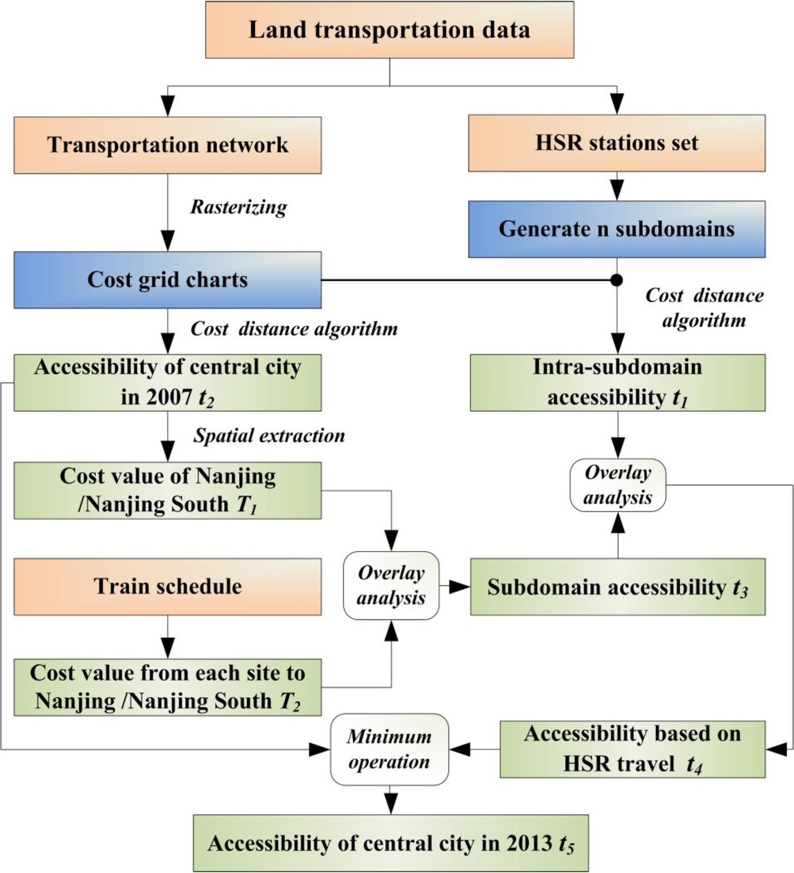
Technique routine of the accessibility model of regional center city
Rasterize the road features to generate cost grid charts (as defined in Table 1) with and without HSR, and use the cumulative cost distance algorithm to generate n subdomains;
Use the Cost Distance Toolbox in ArcGIS to calculate the cost grid charts of the intra-site’s accessibility, t1, for each separate subdomain;
Calculate cost grid charts of accessibility, t2, for the entire area of Nanjing without HSR and extract the cost value, T1, from the Nanjing station to the Nanjing south railway station;
Query the train schedules to obtain the shortest time, T2, for each site to the Nanjing station or the Nanjing south railway station and add it to T1, with the results being assigned to the subdomain to generate cost grid charts t3;
Add cost grid charts, t1 and t3, to the space congruence function of the GIS, which yields the cost grid charts of accessibility, t4, for the entire area of Nanjing due to HSR;
Use the Cell Statistic function in ArcGIS and the minimum algorithm between t2 and t4 to obtain the final cost grid chart, t5.
3.2 Gravity Model
The gravity model is used to figure out the economic link intensity between cities. The essence of this model is to simulate “distance-decay regularity” that characterizes interactions between cities. The distance-decay regularity is a phenomenon reflecting that interactions gradually weaken with increase in geographical distance. It is one of the classic and important fundamental rules of geography. Converse [26] proposed the Breaking Point Theory and deemed that the appeal of a city to its surrounding regions is in direct proportion to the urban size, while inversely proportional to the square of the distances between them. Such a theory is derived from large quantities of case studies and has been verified in corresponding investigations [27]. At present, this is considered to be a widely applied theory about urban space relations [28]. Therefore, the gravity equation presented below [26] is employed:
where F ij refers to the mutual attraction between City i and City j; Pi and Pj are the sizes of the starting points, City i and City j; Dij refers to time distance between City i and City j (in minutes); K refers to a gravitational constant and it is usually taken to be 1; b refers to distance friction coefficient, and its magnitude signifies the deviation in scale of sphere of gravitational interaction which is set to 2.
To comprehensively analyze the influence of HSR on economic linkage, the “economics strength index” is adopted here to modify the gravity model proposed by Converse [26]. The “economics strength index” of a city describes the comprehensive economic strength of a city and its capacity for radiation and promotion. Its computational formula is given below:
where Pi is the economics strength index of node i;mis the number of principal components with eigenvalue greater than 1; Ak is the contribution rate of a principal component of rank k; Ckj is the load of the principal component k on an index of rank j; n is the number of variables; and X ′ ij is a new value obtained to make index j of node i dimensionless.
In this study, eight economic indicators are employed, including GDP, the added value of secondary/tertiary industry, GDP per capita, total sales of social consumer goods, total investment in fixed assets, general financial revenue, and permanent resident population. The original data must be first normalized (formula 6) to guarantee a unified scale, and then we can use SPSS software to perform principal component analysis.
wherein, Xij is the score of common factor j of node i ., max(Xj) and min(Xj) are respectively the maximal and minimal values of the common factor j, and X ′ ij is the standard value of the normalized common factor j of node i.
4 Results and Analysis
4.1 Variation of Accessibility Pattern
4.1.1 Accessibility Pattern at Regional Scale
Spatial distance, time distance, and economic distance are fully considered in the region-oriented accessibility evaluation model. Through averaging the three distances of each urban node on a weighted basis, the accessibility of each of the 31 research units in South Jiangsu is obtained. Spatial interpolation is carried out with the tension spline function interpolation method, and it is divided into several grades at the same interval (10 min). The result is shown in Figure 3.
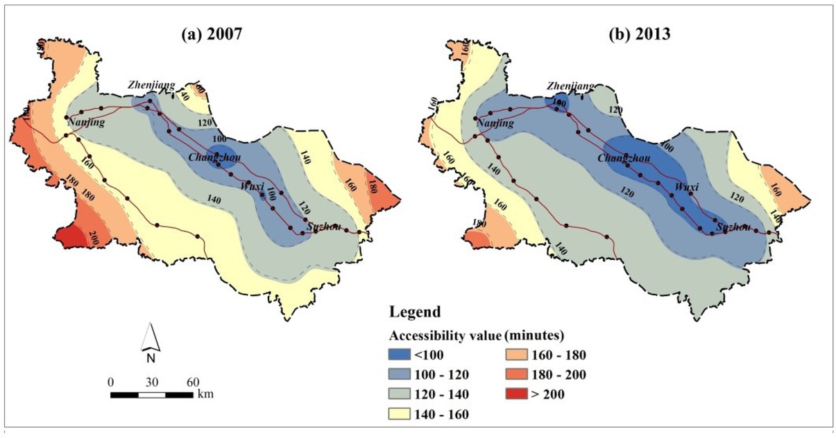
The contour of the accessibility value at regional scale
There are significant spatial differences in the effect of high-speed rail on the accessibility of South Jiangsu. The accessibility is high in the northern and central areas and low in the southern and marginal areas. Overall, from least-accessible Suzhou, Wuxi, and Changzhou to areas outside these three cities, the accessibility gradually increases, presenting an irregular annular distribution. With the launch of high-speed rail, accessibility in the northern and central areas have greatly improved, where over half of the low-accessibility research nodes are located (less than 120 min). After the implementation of high-speed rail, those along the rail lines have become more accessible than the geometric centers, and the areas around the Shanghai-Nanjing railway line and Nanjing-Hangzhou railway line have greatly improved in accessibility. Thanks to high-speed rails, highly accessible corridors are created, yielding the corridor effect.
4.1.2 Accessibility Pattern of Regional Center City
Isochrone maps display areas of similar travel time from a selected starting location, and it reflects the degree of compactness of the spatial association between the central city and the neighboring regions. The uneven pattern of change in accessibility is measured by the range, intensity, and direction of the isotime circle. In this study, based on a 30-minute time cost, the entire area was divided into 7 isochronous rings—30 minutes, 60 minutes, 90 minutes, 120 minutes, 150 minutes, 180 minutes, and more than 180 minutes. From Figure 4, we know that with the operation of HSR, isochronous rings lapse outward with the HSR line, as the 90-minute isochronous ring along the Nanjing-Hangzhou high-speed line extends to Liyang and Yixing, and the 120-minute isochronous ring along the Shanghai-Nanjing and Beijing-Shanghai high-speed lines extends to Kunshan. In other words, the operation of HSR clearly expands the ranges of the 90- and 120-minute isochronous rings. Along HSR, isotime circles clearly move outwards and their spatial scale extends axially. The analysis suggests that the effect of the HSR is much more significant in intermediate and long distance regions.
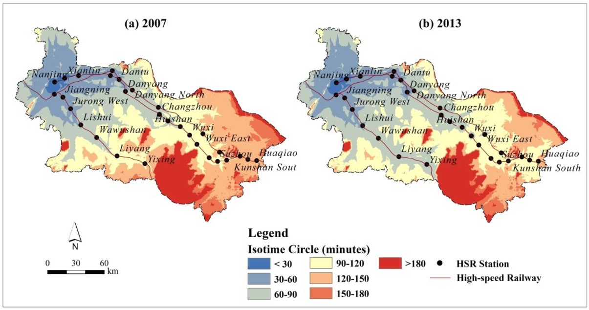
Isochronous rings and change rate of accessibility value at regional center city scale
The higher the variation rate of the accessibility value, the greater the distance from Nanjing is and the less the distance to the HSR station is. While the compression efficiency of travel time in each city is remarkably different, the compression rates are higher along the HSR sites (e.g., change rate in Liyang, Yixing, East Wuxi and South Kunshan station exceed 30%), which are the major beneficiaries of time convergence. Areas with low change rates—less than 5%—are distributed, for the most part, in the peripheral regions of Nanjing. Due to its proximity, the HSR has less impact on the compression effect in those regions. In addition, the change rates of accessibility are low toward the outer edges of the study area and in areas away from an HSR station, such as Wujiang and Changshou. Thus, HSR services are intended to be medium- and long-distance connections.
4.2 Variation of Economic Linkage
Economic linkage refers to the flow and exchange of economic elements in different regions. Despite the fact that it uses the accessibility research as a basis, economic linkage deepens the accessibility research and is an in-depth exploration into the degree of regional interaction. Equation 3 is utilized to determine the economic link intensity between each of the 30 nodes and downtown areas of Nanjing. In this way, a gravity-connecting line distribution diagram can be generated (Figure 5). A bolder connecting line signifies that the economic linkage between this city and the regional hub city is greater.
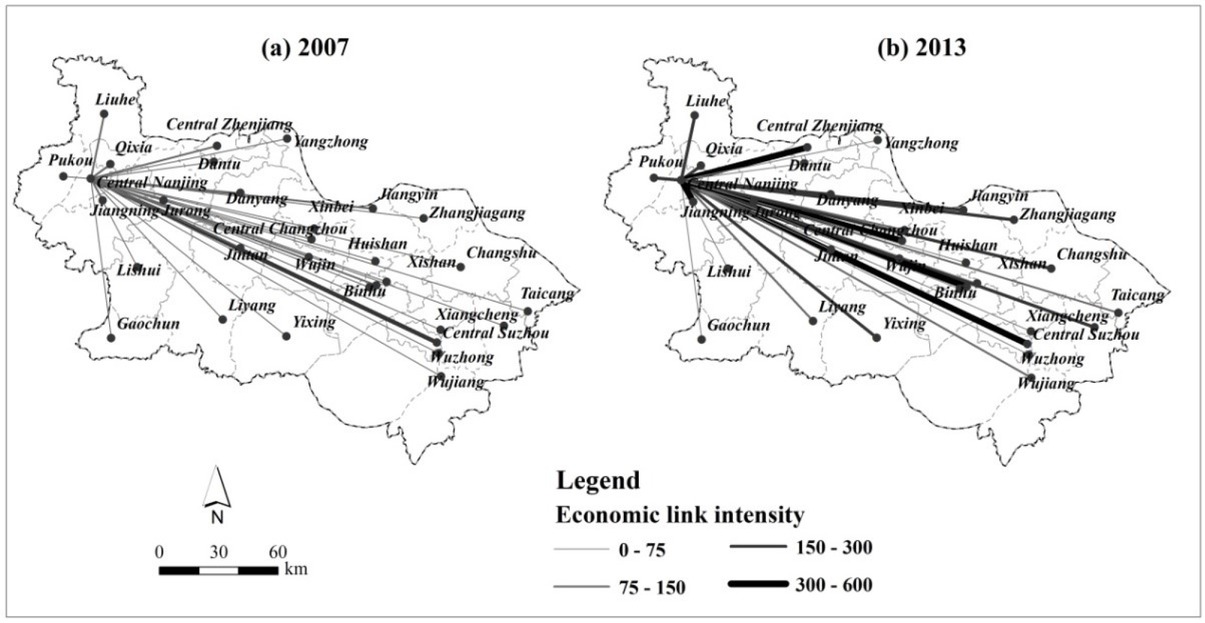
Economic link intensity before and after the operation of HSRs
In 2007, the relation between Nanjing and Central Suzhou was the closest (the economic link intensity is 162.92). After the opening of HSR, the greatest relation intensity exists between downtown areas of Nanjing and Central Zhenjiang (594.76), followed by the link between Nanjing and Central Suzhou (487.83). Clearly, the mutual relation of urban space conforms to the distance-decay regularity, and HSR plays a particularly dominant role in the development of economic linkage patterns. However, for cities without HSR available, economic link intensity is improved limitedly, such as Gaochun District (34.51), Lishui District (42.97), and Yangzhong City (20.90). As a whole, improvement in traffic accessibility has a significant impact on the economic linkage pattern, and the interrelation between cities along the lines of high-speed rail and Nanjing is also evidently enhanced. Among those lines, the connections between Nanjing and Central Zhenjiang, Central Nanjing and Central Wuxi, and Central Nanjing and Central Changzhou are the most enhanced. In summary, the opening of HSR consolidates the core dominant positions of municipal districts.
From the perspective of high-speed railway lines, the economic linkage between nodes on the Nanjing-Hangzhou HSR is weaker than that on the Shanghai-Nanjing HSR and Beijing-Shanghai HSR. Except for significant improvement between the downtown areas of Nanjing and Jiangning District (rises from 129.09 to 401.41), the economic link intensity of other cities is rather low. On one hand, the opening of Shanghai-Nanjing HSR and Beijing-Shanghai HSR is earlier than Nanjing-Hangzhou HSR, and the former two railways have more trains and larger densities. Therefore, HSR has a substantial influence on economic linkage. On the other hand, economic strength of cities along the Nanjing-Hangzhou HSR is lower than that along the Shanghai-Nanjing HSR and the Beijing-Shanghai HSR. This leads to a weak economic linkage among nodes of districts and counties along the Shanghai-Nanjing HSR.
5 Discussion and Conclusions
5.1 Discussion
5.1.1 The unfairness of HSR effect and its potential influence
The topic of accessibility is considered in the context of the transformation from qualitative research to orientation analysis of geography. Accessibility has been measured according to a place-based perspective [29]. Despite increasingly deepening research on accessibility and other measuring indexes, characterization of the effects, practical significance, and intelligibility of indexes are quite different. This study attempted to obtain the routes along which a minimum cost was required regardless of time and distance, through the estimation of fares, and measured the evolvement of the accessibility of South Jiangsu, as a function of space, time, and cost.
According to the result analysis, HSR has significantly improved the external accessibility of cities but such improvement is not evenly distributed among various cities. It has demonstrated the existence of an uneven space-time convergence on the regional and central-city scales. On one hand, a low-to-high accessibility pattern is exhibited from north to south and from center to edge in South Jiangsu, and the cities where high-speed railway stations exist enjoy more benefits from the change in accessibility. On the other hand, an inequality in the accessibility distribution has been found in the regional central city. Statistically, isochronous rings of 90 minutes and 120 minutes have significantly expanded in scope due to HSR. The 120- to 150-minute rings suffered a substantial reduction in area, suggesting that the influence on the medium or distant areas were particularly more violent and outstanding.
It is not difficult to debate the effects of HSR from the above discussion. Are there siphon effects making neighboring cities lose profits? Are there diffusion effects making neighboring cities receive greater profits? The accessibility effect could result in regional economic cooperation eradicating the traditional geographic boundaries and, thus, promote greater competition among cities [30, 31]. This reminds us that some small cities and less developed areas in this region have not profited significantly since HSR came into service, but rather were left further behind, which requires much attention from local governments.
5.1.2 More time is consumed outside the railway system in the total travel, which calls for policy decisions
After researching the accessibility of railway stations in Holland, Rietveld [32] concluded that the market potential for railway service largely depends on the quality of the entire journey from origin to destination. That is to say, the quality of neither end of the travel chain has been improved in nature because of the operation of HSR. Does this summary equally apply to HSR in China? To determine this, we separated the time cost of internal city transport (TO and TD) from the accessibility value, and calculated its proportion (see Figure 6) It is evident that the proportion of the internal city’s transport time cost is greater than 0.5 at more than half of the research nodes. These cities are usually nearer to central cities. Furthermore, there are larger
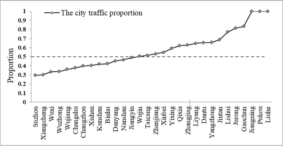
The proportion taken by internal transportation time in the whole travel time
differences between the time cost for HSR (TOD) and the time cost for internal city transport (TO and TD). We can take Lishui and Jurong as examples. It takes 15 minutes on the HSR, but more than 45 minutes to reach and leave the HSR stations.
We can further conclude from above discussion that the time saved by HSR will be offset by the distance between downtown and an HSR station that is far from the city center. The accessibility of regions that are well connected in transportation with HSR stations has largely improved, while the accessibility of regions that are poorly connected in transportation with HSR stations has improved with reduced effects. Therefore, internal transportation of neighboring cities must be improved to achieve seamless connections between HSR stations and other transportation stations, reducing transfer time. Marginal regions can improve their accessibility by building other fast transportation channels, connecting with HSR stations and strengthening the transportation connections with HSR. Deriving a comprehensive post-HSR planning strategy for a more integrated transportation system would be useful for local authorities [33].
5.2 Conclusions
Tierney [34] viewed HSR as the next economic growth wave. HSR is a large-scale form of public infrastructure that delivers significant public benefits and economic externalities. This study constructs an accessibility evaluation model to operate on the mesoscale and macro-scale. Accessibility is measured with basic factors including spatial distance, time distance (time spent in spanning spatial distance), and economic distance (expense for spanning spatial distance). A novel zone partitioning method has been proposed to resolve access problems for closed-type roads, such as the HSR. Gravity model based the accessibility research is used to take an in-depth exploration into the economic linkage pattern. The result shows that HSRs increase regional space-time contraction, reduce the resistance between areas and offer direct impetus for the economic and spatial structure. The mutual relation of urban space conforms to the distance-decay regularity, and HSR plays a particularly dominant role in the development of economic linkage patterns.
HSR has created a multitude of new and thought-provoking research fields, along with the transformation of methods and perspectives. While scholars have already addressed the impact of HSR, further improvements in terms of methods, scope, and perspectives are still warranted. This study does not address the impact of the increasing urban road congestion on accessibility. Also, it only focuses on the research between the internal cities at urban agglomeration scale, while regional economic system is an open and complex one. These problems will be addressed in subsequent research.
References
[1] Gutiérrez J., Location, economic potential and daily accessibility: an analysis of the accessibility impact of the high-speed line Madrid-Barcelona-French border. J. Transp. Geogr. 2001, 9, 229-24210.1016/S0966-6923(01)00017-5Suche in Google Scholar
[2] Kim K.S., High-speed rail developments and spatial restructuring: a case study of the Capital region in South Korea. Cities 2000, 17(4), 251-26210.1016/S0264-2751(00)00021-4Suche in Google Scholar
[3] Sasaki K., Ohashi T., Ando A., High-speed rail transit impact on regional systems: does the Shinkansen contribute to dispersion? Ann. Regional Sci. 1997, 31(1), 77-9810.1007/s001680050040Suche in Google Scholar
[4] Bonnafous A., The regional impact of the TGV. Transportation 1987, 14(2), 127-13710.1007/BF00837589Suche in Google Scholar
[5] Vickerman R., Spiekermann K., Wegener M., Accessibility and economic development in Europe. Reg. Stud. 1999, 33(1), 1-1510.1080/00343409950118878Suche in Google Scholar
[6] Miller H.J., Wu Y., GIS software for measuring space-time accessibility in transportation planning and analysis. Geoinformatica 2000, 4(2), 141-15910.1023/A:1009820006075Suche in Google Scholar
[7] Gutiérrez J., González R., Gómez G., The European high-speed train network: predicted effects on accessibility patterns. J. Transp. Geogr. 1996, 4(4), 227-23810.1016/S0966-6923(96)00033-6Suche in Google Scholar
[8] Jiao J., Wang J., Jin F., Dunford, M., Impacts on accessibility of China’s present and future HSR network. J. Transp. Geogr. 2014, 40, 123-13210.1016/j.jtrangeo.2014.07.004Suche in Google Scholar
[9] Cao J., Liu X.C., Wang Y., Li, Q., Accessibility impacts of China’s high-speed rail network. J. Transp. Geogr. 2014, 28, 12-2110.1016/j.jtrangeo.2012.10.008Suche in Google Scholar
[10] Qi F., Methods discussion on impact of High-speed rail on noise environmental. Environ. Prot. 1994, 12, 35-37 (in Chinese with English abstract)Suche in Google Scholar
[11] Jiang H., Zhang W., Li Y., Impact of the Beijing-Shanghai high-speed rail on the spatial pattern of the regional road accessibility. J. East China Norm. Uni., (Natural Science) 2014, 68-78 (in Chinese with English abstract)Suche in Google Scholar
[12] Zhou H., Yu J., Railway speed-up, accessibility and urban economic growth in China. Econ. Rev. 2013, 33, 52-59 (in Chinese with English abstract)Suche in Google Scholar
[13] Shaw S., Fang Z., Lu S., Tao R., Impacts of high speed rail on railroad network accessibility in China. J. Transp. Geogr. 2014, 40, 112-12210.1016/j.jtrangeo.2014.03.010Suche in Google Scholar
[14] Andrew R., High speed rail. J. Transp. Geogr. 2012, 22, 303-30510.1016/j.jtrangeo.2012.03.004Suche in Google Scholar
[15] Miller H.J., Measuring space-time accessibility benefits within transportation networks: basic theory and computational procedures. Geogr. Anal. 1999, 31(1), 1-2610.1111/j.1538-4632.1999.tb00408.xSuche in Google Scholar
[16] Naude A., Jong T.D., and Teefelen P.V., Measuring accessibility with GIS-tools: a case study of the Wild Coast of South Africa. T. GIS 1999, 3(3), 381-39510.1111/1467-9671.00033Suche in Google Scholar
[17] Hansen W.G., How accessibility shapes land use. J. Am. Plann. 1959, 25(2), 73-7610.1080/01944365908978307Suche in Google Scholar
[18] Morris J.M., Dumble P.L., Wigan M.R., Accessibility indicators for transport planning. Transport Res. A- Gen. 1979, 13(2), 91-10910.1016/0191-2607(79)90012-8Suche in Google Scholar
[19] Koopmans C., Groot W., Warffemius P., Annema J.A., Hoogendoorn-Lanser S., Measuring generalised transport costs as an indicator of accessibility changes over time. Transp. Policy 2013, 29 154-15910.1016/j.tranpol.2013.05.005Suche in Google Scholar
[20] Ford A., Barr S., Dawson R. and James P., Transport accessibility analysis using GIS: Assessing sustainable transport in London. ISPRS Int. J. Geo-Inf. 2015, 4(1): 124-14910.3390/ijgi4010124Suche in Google Scholar
[21] Siljander M., Venäläinen E., Goerlandt F., Pellikka P., GIS-based cost distance modelling to support strategic maritime search and rescue planning: A feasibility study. Appl. Geogr. 2015, 57,54-7010.1016/j.apgeog.2014.12.013Suche in Google Scholar
[22] Chen J., Lu F., Cheng C., Advance in accessibility evaluation approaches and applications. Prog. Geog. 2007, 26, 100-110 (in Chinese with English abstract)Suche in Google Scholar
[23] Lu J., Song J., Liang Y., Xu J., The simulation of spatial distribution patterns of China’s HSR-economic zones based on the 2D time-space map. Acta Geogr. Sin. 2013, 68, 147-158 (in Chinese with English abstract)Suche in Google Scholar
[24] Salonen M. and Toivonen T., Modelling travel time in urban networks: comparable measures for private car and public transport. J. Transp. Geogr. 2013, 31(6): 143-15310.1016/j.jtrangeo.2013.06.011Suche in Google Scholar
[25] Wang L., Liu Y., Sun C. and Liu Y., Accessibility impact of the present and future high-speed rail network: A case study of Jiangsu Province, China. J. Transp. Geogr. 2016, 54: 161-17210.1016/j.jtrangeo.2016.05.015Suche in Google Scholar
[26] Converse P.D., New laws of Retail Gravitation. J. Marketing 1949, 14(3): 379-38410.1177/002224295001400303Suche in Google Scholar
[27] Liu K. and Shen Y., Review of research on regional spatial interaction at home and abroad. World Reg. Stud. 2014, 23(1): 73-83 (in Chinese with English abstract)Suche in Google Scholar
[28] Yan W., Wang F. and Qin Y., Analysis of the principle and evolvement of the theoretic models of urban spatial interaction. Prog. Geog. 2009, 28(4): 511-518 (in Chinese with English abstract)Suche in Google Scholar
[29] Charleux L., A GIS toolbox for measuring and mapping person-based space-time accessibility. T. GIS 2014, 19(2), 262-27810.1111/tgis.12115Suche in Google Scholar
[30] van Eck J.R., De Jong T., Accessibility analysis and spatial competition effects in the context of GIS-supported service location planning. Comput. Environ. Urban 1999, 23(2), 75-8910.1016/S0198-9715(99)00016-2Suche in Google Scholar
[31] Vickerman R., High-speed rail and regional development: the case of intermediate stations. J. Transp. Geogr. 2015, 42, 157-16510.1016/j.jtrangeo.2014.06.008Suche in Google Scholar
[32] Rietveld P., The accessibility of railway stations: the role of the bicycle in The Netherlands. Transport Res. D-TR. E. 2000, 5(1), 71-7510.1016/S1361-9209(99)00019-XSuche in Google Scholar
[33] Cheng Y., High-speed rail in Taiwan: new experience and issues for future development. Transp. Policy 2010, 17(2), 51-6310.1016/j.tranpol.2009.10.009Suche in Google Scholar
[34] Tierney S., High-speed rail, the knowledge economy and the next growth wave. J. Transp. Geogr. 2012, 22, 285-28710.1016/j.jtrangeo.2012.01.026Suche in Google Scholar
© 2019 W. Hong and M. Su, published by De Gruyter
This work is licensed under the Creative Commons Attribution 4.0 Public License.
Artikel in diesem Heft
- Regular Articles
- 2D Seismic Interpretation of the Meyal Area, Northern Potwar Deform Zone, Potwar Basin, Pakistan
- A new method of lithologic identification and distribution characteristics of fine - grained sediments: A case study in southwest of Ordos Basin, China
- Modified Gompertz sigmoidal model removing fine-ending of grain-size distribution
- Diagenesis and its influence on reservoir quality and oil-water relative permeability: A case study in the Yanchang Formation Chang 8 tight sandstone oil reservoir, Ordos Basin, China
- Evaluation of AHRS algorithms for Foot-Mounted Inertial-based Indoor Navigation Systems
- Identification and evaluation of land use vulnerability in a coal mining area under the coupled human-environment
- Hydrocarbon Generation Potential of Chia Gara Formation in Three Selected Wells, Northern Iraq
- Source Analysis of Silicon and Uranium in uranium-rich shale in the Xiuwu Basin, Southern China
- Lithologic heterogeneity of lacustrine shale and its geological significance for shale hydrocarbon-a case study of Zhangjiatan Shale
- Characterization of soil permeability in the former Lake Texcoco, Mexico
- Detrital zircon trace elements from the Mesozoic Jiyuan Basin, central China and its implication on tectonic transition of the Qinling Orogenic Belt
- Turkey OpenStreetMap Dataset - Spatial Analysis of Development and Growth Proxies
- Morphological Changes of the Lower Ping and Chao Phraya Rivers, North and Central Thailand: Flood and Coastal Equilibrium Analyses
- Landscape Transformations in Rapidly Developing Peri-urban Areas of Accra, Ghana: Results of 30 years
- Division of shale sequences and prediction of the favorable shale gas intervals: an example of the Lower Cambrian of Yangtze Region in Xiuwu Basin
- Fractal characteristics of nanopores in lacustrine shales of the Triassic Yanchang Formation, Ordos Basin, NW China
- Selected components of geological structures and numerical modelling of slope stability
- Spatial data quality and uncertainty publication patterns and trends by bibliometric analysis
- Application of microstructure classification for the assessment of the variability of geological-engineering and pore space properties in clay soils
- Shear failure modes and AE characteristics of sandstone and marble fractures
- Ice Age theory: a correspondence between Milutin Milanković and Vojislav Mišković
- Are Serbian tourists worried? The effect of psychological factors on tourists’ behavior based on the perceived risk
- Real-Time Map Matching: A New Algorithm Integrating Spatio-Temporal Proximity and Improved Weighted Circle
- Characteristics and hysteresis of saturated-unsaturated seepage of soil landslides in the Three Gorges Reservoir Area, China
- Petrographical and geophysical investigation of the Ecca Group between Fort Beaufort and Grahamstown, in the Eastern Cape Province, South Africa
- Ecological risk assessment of geohazards in Natural World Heritage Sites: an empirical analysis of Bogda, Tianshan
- Integrated Subsurface Temperature Modeling beneath Mt. Lawu and Mt. Muriah in The Northeast Java Basin, Indonesia
- Go social for your own safety! Review of social networks use on natural disasters – case studies from worldwide
- Forestry Aridity Index in Vojvodina, North Serbia
- Natural Disasters vs Hotel Industry Resilience: An Exploratory Study among Hotel Managers from Europe
- Using Monarch Butterfly Optimization to Solve the Emergency Vehicle Routing Problem with Relief Materials in Sudden Disasters
- Potential influence of meteorological variables on forest fire risk in Serbia during the period 2000-2017
- Controlling factors on the geochemistry of Al-Shuaiba and Al-Mejarma coastal lagoons, Red Sea, Saudi Arabia
- The Influence of Kaolinite - Illite toward mechanical properties of Claystone
- Two critical books in the history of loess investigation: ‘Charakteristik der Felsarten’ by Karl Caesar von Leonhard and ‘Principles of Geology’ by Charles Lyell
- The Mechanism and Control Technology of Strong Strata Behavior in Extra-Thick Coal Seam Mining Influenced by Overlying Coal Pillar
- Shared Aerial Drone Videos — Prospects and Problems for Volunteered Geographic Information Research
- Stable isotopes of C and H in methane fermentation of agriculture substrates at different temperature conditions
- Prediction of Compression and Swelling Index Parameters of Quaternary Sediments from Index Tests at Mersin District
- Detection of old scattered windthrow using low cost resources. The case of Storm Xynthia in the Vosges Mountains, 28 February 2010
- Remediation of Copper and Zinc from wastewater by modified clay in Asir region southwest of Saudi Arabia
- Sedimentary facies of Paleogene lacustrine dolomicrite and implications for petroleum reservoirs in the southern Qianjiang Depression, China
- Correlation between ore particle flow pattern and velocity field through multiple drawpoints under the influence of a flexible barrier
- Atmospheric refractivity estimation from AIS signal power using the quantum-behaved particle swarm optimization algorithm
- A geophysical and hydro physico-chemical study of the contaminant impact of a solid waste landfill (swl) in King Williams’ Town, Eastern Cape, South Africa
- Landscape characterization using photographs from crowdsourced platforms: content analysis of social media photographs
- A Study on Transient Electromagnetic Interpretation Method Based on the Seismic Wave Impedance Inversion Model
- Stratigraphy of Architectural Elements of a Buried Monogenetic Volcanic System
- Variable secondary porosity modeling of carbonate rocks based on μ-CT images
- Traditional versus modern settlement on torrential alluvial fans considering the danger of debris flows: a case study of the Upper Sava Valley (NW Slovenia)
- The Influence of Gangue Particle size and Gangue Feeding Rate on Safety and Service Life of the Suspended Buffer’s Spring
- Research on the Transition Section Length of the Mixed Workface Using Gangue Backfilling Method and Caving Method
- Rainfall erosivity and extreme precipitation in the Pannonian basin
- Structure of the Sediment and Crust in the Northeast North China Craton from Improved Sequential H-k Stacking Method
- Planning Activities Improvements Responding Local Interests Change through Participatory Approach
- GIS-based landslide susceptibility mapping using bivariate statistical methods in North-western Tunisia
- Uncertainty based multi-step seismic analysis for near-surface imaging
- Deformation monitoring and prediction for residential areas in the Panji mining area based on an InSAR time series analysis and the GM-SVR model
- Statistical and expert-based landslide susceptibility modeling on a national scale applied to North Macedonia
- Natural hazards and their impact on rural settlements in NE Romania – A cartographical approach
- Rock fracture initiation and propagation by mechanical and hydraulic impact
- Influence of Rapid Transit on Accessibility Pattern and Economic Linkage at Urban Agglomeration Scale in China
- Near Infrared Spectroscopic Study of Trioctahedral Chlorites and Its Remote Sensing Application
- Problems with collapsible soils: Particle types and inter-particle bonding
- Unification of data from various seismic catalogues to study seismic activity in the Carpathians Mountain arc
- Quality assessment of DEM derived from topographic maps for geomorphometric purposes
- Remote Sensing Monitoring of Soil Moisture in the Daliuta Coal Mine Based on SPOT 5/6 and Worldview-2
- Utilizing Maximum Entropy Spectral Analysis (MESA) to identify Milankovitch cycles in Lower Member of Miocene Zhujiang Formation in north slope of Baiyun Sag, Pearl River Mouth Basin, South China Sea
- Stability Analysis of a Slurry Trench in Cohesive-Frictional Soils
- Integrating Landsat 7 and 8 data to improve basalt formation classification: A case study at Buon Ma Thuot region, Central Highland, Vietnam
- Assessment of the hydrocarbon potentiality of the Late Jurassic formations of NW Iraq: A case study based on TOC and Rock-Eval pyrolysis in selected oil-wells
- Rare earth element geochemistry of sediments from the southern Okinawa Trough since 3 ka: Implications for river-sea processes and sediment source
- Effect of gas adsorption-induced pore radius and effective stress on shale gas permeability in slip flow: New Insights
- Development of the Narva-Jõesuu beach, mineral composition of beach deposits and destruction of the pier, southeastern coast of the Gulf of Finland
- Selecting fracturing interval for the exploitation of tight oil reservoirs from logs: a case study
- A comprehensive scheme for lithological mapping using Sentinel-2A and ASTER GDEM in weathered and vegetated coastal zone, Southern China
- Sedimentary model of K-Successions Sandstones in H21 Area of Huizhou Depression, Pearl River Mouth Basin, South China Sea
- A non-uniform dip slip formula to calculate the coseismic deformation: Case study of Tohoku Mw9.0 Earthquake
- Decision trees in environmental justice research — a case study on the floods of 2001 and 2010 in Hungary
- The Impacts of Climate Change on Maximum Daily Discharge in the Payab Jamash Watershed, Iran
- Mass tourism in protected areas – underestimated threat? Polish National Parks case study
- Decadal variations of total organic carbon production in the inner-shelf of the South China Sea and East China Sea
- Hydrogeothermal potentials of Rogozna mountain and possibility of their valorization
- Postglacial talus slope development imaged by the ERT method: comparison of slopes from SW Spitsbergen, Norway and Tatra Mountains, Poland
- Seismotectonics of Malatya Fault, Eastern Turkey
- Investigating of soil features and landslide risk in Western-Atakent (İstanbul) using resistivity, MASW, Microtremor and boreholes methods
- Assessment of Aquifer Vulnerability Using Integrated Geophysical Approach in Weathered Terrains of South China
- An integrated analysis of mineralogical and microstructural characteristics and petrophysical properties of carbonate rocks in the lower Indus Basin, Pakistan
- Applicability of Hydrological Models for Flash Flood Simulation in Small Catchments of Hilly Area in China
- Heterogeneity analysis of shale reservoir based on multi-stage pumping data