Utilizing Maximum Entropy Spectral Analysis (MESA) to identify Milankovitch cycles in Lower Member of Miocene Zhujiang Formation in north slope of Baiyun Sag, Pearl River Mouth Basin, South China Sea
-
Rui Yuan
 ,
Shiwen Xie
,
Shiwen Xie

Abstract
Logs in the petroleum boreholes indirectly records the sedimentary cycles in the deep burial formation. In order to extract and understand the periodicity and cyclicity, it is necessary to process the data by digital signal analysis method. Taking the gamma ray (GR) log as the primary material, an identification approach of Milankovitch cycles in boreholes is proposed in this paper, which is based on the Maximum Entropy Spectral Analysis (MESA). The first stage chooses the appropriate windows for calculating the frequency spectral properties in a short section of the data. In each depth window, the second stage generates the two-dimension frequency spectrum utilizing the MESA. At each depth point, the third stage finds the potential Milankovitch cycles in the one-dimension frequency spectrum, in which the average amplitude spectrum peak would be matched to the ratio of Milankovitch period. According to the frequency and wavelength of the maximum amplitude in Milankovitch cycles, the fourth stage estimates the sedimentation rate controlled by cyclical factor. Finally, the Milankovitch cycles in Lower Member of Miocene Zhujiang Formation in north slope of Baiyun Sag, Pearl River Mouth Basin, are identified and the cyclical sedimentation rate is estimated. The results demonstrate that the proposed method is feasible and effective to identify Milankovitch cycles in boreholes, which may contribute to the other geological researches.
1 Introduction
Quasi-periodicity or periodicity is the common phenomenon for almost every object in the universe. Derived from the astronomical cyclical movement, the deposition processes and sediment sequences of the Earth are within the cyclicity and periodicity as well. The quasi-periodic variations of the precession, obliquity and eccentricity of the Earth orbital parameters generate different features and rhythmicity records in the sedimentary rocks, called Milankovitch cycles in geology [1]. However, the outcrops in fields and cores in petroleum wells just provide a small part of the formation. It is impossible to directly view and observe the cycles in the deep burial sedimentary rocks continuously. Fortunately, logs in the boreholes can continuously collect the features of the underground sediments, which offers other indirect materials to research the Milankovitch cycles [2, 3, 4]. These digital signals may consist by various stacked cyclical indexes, and one of the challenges is how to analyze the sedimentary records and to find the information that indicate the cyclicity in the stratigraphy and cyclostratigraphy.
Recent advances in signal analysis provide many approaches in different theories for this problem, such as Multitaper method (MTM) [5, 6, 7], Average Spectral Misfit (ASM) [8, 9], first-order autoregressive (AR1) [10], Evolutive Harmonic Analysis (EHA) [11], Time Scale Optimization (TimeOpt) [12, 13], Wavelet Transform (WT) [14, 15, 16, 17, 18], Fast Fourier Transform (FFT) [2, 4, 19] and so on. However, MTM, ASM, AR1, EHA and TimeOpt prefer discrete astronomical and climatological experimental data sampled in regularly-space [5, 6, 7, 8, 9, 10, 11, 12, 13], and WT and FFT, spectral analysis methods, are generally applied to continuous date in boreholes [14, 15, 16, 17, 18]. The primary reason for using spectral methods is the understanding that cyclical climatic changes are recorded in strata, which can therefore be expected to contain information in the frequency domain [19, 20, 21]. If a wireline log is viewed as a series of data points and a regularly-spaced sampling of a complex waveform, then spectral analysis methods are required to fully understand it.
However, WT methods have advantages in the original data with very spiky-large spikes which would dominate the frequency spectra to the point and lead to the obscure of the interesting frequencies. Although FFT may be the most familiar method in other applications, it attempts to decompose the data into exact sine waves, which are very rarely in the geological data. Maximum Entropy Spectral Analysis (MESA), another widely used spectral analysis approach, is much more tolerant of any imperfections in the expression of an underlying periodicity, such as Milankovitch cyclicity, by generating a model of the data rather than an exact decomposition mathematically [22]. Based on the MESA, a method of identifying the Milankovitch cycles and estimating the cyclical sedimentation rate in the Lower Member of Miocene Zhujiang Formation in north slope of Baiyun Sag, Pearl River Mouth Basin, is introduced in this paper.
2 Milankovitch cycles
The Earth’s orbit around the Sun is influenced by gravitational attractions of the Moon and the other planets in the solar system, which produces the quasi-periodic variations, termed Milankovitch theory, in the orbital parameters: precession, obliquity and eccentricity (Figure 1) [23, 24]. At present, the precession of equinoxes refers to the wobble of the Earth on its axis with major periods of ~23.00 and ~19.00 kyr. The obliquity, varies between 22.1∘ and 24.5∘, is oscillation of the Earth’s axial tilt with major periods of ~41.00 kyr and secondary period of ~29.00 and ~54.00 kyr. As the elliptical orbit, eccentricity varies between 0.0005 and 0.0607 with long period of ~413.00 kyr and short period of ~95.00 and ~123.00 kyr (average in 100.00 kyr) [23, 24]. At different geological age, these orbital parameters would be slightly changed (Table 1) [25].
![Figure 1 Sketch of the Earth’s orbit. The precession, obliquity and eccentricity are three important orbital parameters [24].](/document/doi/10.1515/geo-2019-0068/asset/graphic/j_geo-2019-0068_fig_001.jpg)
Sketch of the Earth’s orbit. The precession, obliquity and eccentricity are three important orbital parameters [24].
Part Milankovitch periods in different geological age [25].
| Geological age | Eccentricity period | Obliquity | Precession two | ||
|---|---|---|---|---|---|
| long | short | period | major period | ||
| Recent | 413.000 | 100.000 | 41.000 | 23.000 | 19.000 |
| Tertiary | 413.000 | 100.000 | 40.000 | 22.500 | 19.000 |
| Cretaceous | 413.000 | 100.000 | 39.300 | 22.500 | 18.600 |
| Upper-Jurassic | 413.000 | 100.000 | 38.100 | 22.000 | 18.300 |
| Lower-Jurassic | 413.000 | 100.000 | 37.600 | 21.800 | 18.200 |
| Triassic | 413.000 | 100.000 | 37.000 | 21.000 | 18.000 |
| Lower-Permian | 413.000 | 100.000 | 35.145 | 21.034 | 17.638 |
| Carboniferous | 413.000 | 100.000 | 34.200 | 20.700 | 17.400 |
The quasi-periodic variations of the orbital parameters directly control the all of the environment changes on the Earth [26]. Then, the environment influences all intimately linked factors eventually that directly or indirectly control sediment production, transportation and accumulation. Depending on the sensitivity of the sedimentary systems, environment forcing may exist in the stratigraphic records in continuous depositional settings where the preservation potential is high. It is clear that the strata thus indirectly reflect the orbital parameters. Although the orbital changes are not truly cyclical but quasi-periodic, it is commonly accepted by the geological community to call as “Milankovitch cycles” in the stratigraphy and cyclostratigraphy [25].
3 Geological setting
Pearl River Mouth Basin, in the continental shelf northern South China Sea, is a representative rift basin of passive continental margin. Strike in NE-SW, the basin is approximately paralleled with the shoreline of south China continent [27, 28, 29]. It is a vital offshore petroliferous basin of China. In tectonic, Pearl River Mouth Basin is divided into five major structural units from north to south: North Faultterrace zone, North Depression zone, Central Uplift zone, South Depression zone and South Fault-terrace zone (Figure 2a) [27, 28, 29]. Each unit include several sags and uplifts furtherly. As one of the significant oil-rich sags, Baiyun Sag is in North Depression zone, encircled by Panyu Low Uplift, Yunkai Low Bulge and South Fault-terrace zone (Figure 2b).
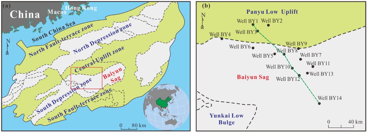
Tectonic features of Pearl River Mouth Basin. (a) Five major structural units in Pearl River Mouth Basin. The Baiyun Sag is in the South Depression zone. (b) Fourteen wells in research region.
Under adequate sediment supplying, steady formations are developed in Baiyun Sag from Eocene to Quaternary. From 32 myr, for the continuous expansion of the South China Sea, the depositional environment changed from lakes to shoreland in Eocene and Oligocene [30]. Then the Pearl River Mouth Basin turned into marine sedimentary stage, when shelf slope break zone maintained at the south of Panyu Low Uplift and north slope of Baiyun Sag (Figure 3a) [30]. Therefore, between 23.8 myr and 18.5 myr, shelf marginal delta was primarily developed to form Lower Member of Zhujiang Formation in Lower Miocene [30]. Constituted by various sands, silts and clays, the thickness of Lower Member of Zhujiang Formation is ranged from 150 m to 400 m (Figure 3b) [30, 31].
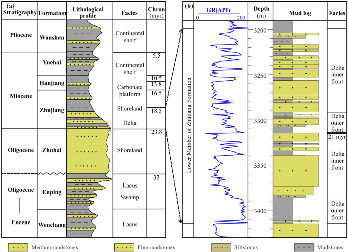
Formations in Baiyun Sag. (a) Formations from Eocene to Quaternary. The Zhujiang Formation is mainly formed by shelf marginal delta. (b) Lower Member of Zhujiang Formation in north slope of Baiyun Sag, Well BY9. Delta front is the dominated depositional environment.
4 Database and methodologies
4.1 Database
There are over 150 petroleum wells in Pearl River Mouth Basin. As a key exploration area, dozens of wells are being drilled in Baiyun Sag in recent years. Fourteen petroleum exploitation wells crossed over the Miocene Formation in the north slope (Figure 2b). In these boreholes, besides mud log, conventional comprehensive logging programs were completed, including gamma ray,self-potential, borehole diameter, resistivity, neutron, sonic and density. As a lithological log, the natural gamma ray (GR) logging values reflect the radioactivity induced by radioactive elements U, Th and K of the rocks. In sand-shale stratigraphic sequence, during long transport, the clay and organic particles would adsorb more radioactive elements from the depositional environment, which are closely related with the change of environment and climate. For the GR log, it shows that high value in mudstones and low value in sandstones (Figure 3b). It means that the GR logging values are sensitive to the lithology which may records the sedimentary cycles [3, 17, 32]. With the sampling interval in 0.1 m, this kind material provides a more detail record of sedimentation history than that determined solely based upon cuttings and limited core analyses in the overall intended formation. For these reasons, GR log is the primary material of this paper. In addition, a three-dimension seismic profile is cited in correlation wells in the discussions.
4.2 Maximum Entropy Spectrum Analysis
In information theory, entropy is defined as a measure of signal uncertainty. Proposed by Burg [33], MESA extracts the periods of different frequency from the time series, which generates the minimum of the power spectrum error and increases the resolution. It is equivalent with the autoregressive model [34]. The prediction error of logging record xi (i=1, 2, ..., N) could be regarded as
Taken 1, −α1, . . . , −αm as filtering factors and ej as the output of the digital filter, a prediction error filter is just designed. In frequency domain, the filter is expressed by
E (ω) is the frequency spectrum of prediction error ej, A(ω) is the frequency spectrum of prediction error filter and X (ω) is the frequency spectrum of the logging xi. The frequency spectrum of the xi is thus
For example, a simulate log has been processed by MESA (Figure 4). The simulate log is synthetized by five logs with constant wavelengths of 41.3 m, 10 m, 4.1 m, 2.3 m and 1.9 m respectively. In the MESA spectral band, frequency spectrum generated by MESA, there are five peaks whose wavelengths are 41.3 m, 10 m, 4.1 m, 2.3 m and 1.9 m respectively. It suggests that MESA is effective to unmix the cycle property in a composite log.
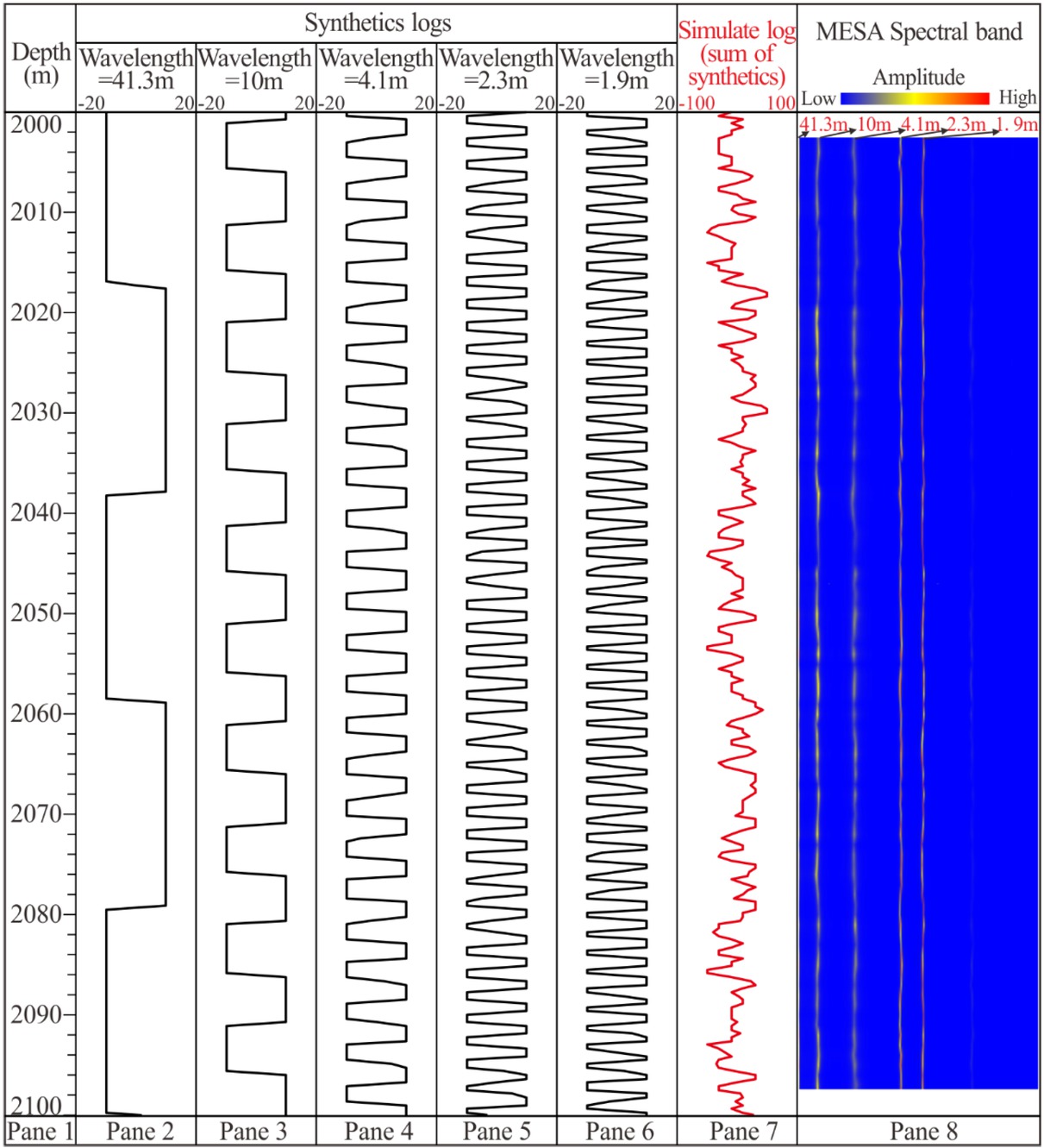
Spectral band of simulate log. From second to sixth pane show synthetic logs with wavelengths of 41.3 m, 10 m, 4.1 m, 2.3 m and 1.9 m respectively. The seventh pane shows the simulate log, sum of the synthetic logs. The eighth pane shows the two-dimension frequency spectral band calculated by MESA (window=30 m). High spectral amplitudes correspond to the wavelengths of 41.3 m, 10 m, 4.1 m, 2.3 m and 1.9 m respectively.
4.3 Used process
Based on the GR log in boreholes, the method using MESA to identify Milankovitch cycles and estimate the cyclical sedimentation rate requires primary depositional features and comprises four stages. During the first stage, the appropriate window is chosen. Computing the frequency spectrum of an entire log would be meaningless, as the statistical properties of geological data are highly variable downhole, “non-stationary” in statistical terms. Consistency of frequency properties is much more likely in a short section of the data. Therefore, frequency spectral is analyzed in a large number of short windows, 30 m, in this paper. In the second stage, two-dimension frequency spectrum in each depth window is calculated upwards. The spectral results are characteristic for the window, and not for the window center. During the third stage, potential Milankovitch cycles in the one-dimension frequency spectrum are found. According to the geological period, the most appropriate orbital parameters should be selected first. At each depth point, average amplitude spectrum peaks would be checked whether match to the ratio of Milankovitch period carefully. If the conformance of the both is good, it will consider that the strata may dominate in the Milankovitch cycles. In the fourth stage, the sedimentation rate controlled by cyclical factor is estimated. In the Milankovitch cycles, the period in the maximum amplitude is regarded as the dominant periodicity that controls the cyclical sedimentary, and the wavelength of the maximum amplitude would imply the sedimentation thickness [25]. The approximated cyclical sedimentation rate is just the ratio of wavelength and period at the maximum amplitude [35].
5 Results
Without exposure and denudation, the sustaining marine sedimentary successions can often preserve more complete record of orbital cycles than lacustrine strata. From 23.8 myr, the north slope of Baiyun Sag was inundated by marine water and the slope break belt is appeared. Until 18.5 myr, Lower Member of Miocene Zhujiang Formation is developed in delta front facies. Between both times, there is another chronologic age recorded by seismic reflection, 21 myr, which divided Lower Member of Zhujiang Formation into two parts. Taking Well BY6 for example, each part comprises lower delta outer front and upper delta inner front (Figure 5). Thick sands would be deposited in delta inner front, and interbed of thick mudstone and thin sands may be developed in delta outer front.
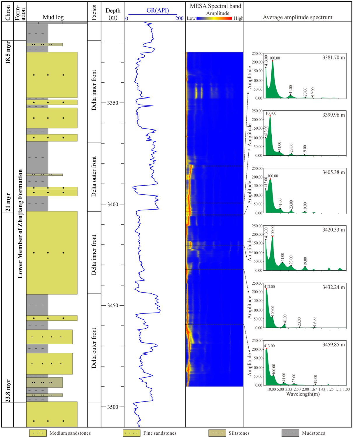
MESA result of Lower Member of Zhujiang Formation in Well BY6. The sandstones are in low GR values and siltstones and mudstones are in high GR values. The two-dimension frequency spectral band is calculated by MESA (window=30 m). Six typical one-dimension frequency spectrum at different depth match the Milankovitch periods.
In order to identify probable Milankovitch cycles in this borehole, GR log is processed utilizing MESA to generate two-dimension spectral band (Figure 5). The GR are high values in sandstone intervals and low values in siltstone and mudstone intervals. In the two-dimension spectral band, the ratio of wavelengths at each depth point should be check carefully to judge whether match the Milankovitch periods approximating wavelengths ratio in 41.3: 10: 4.1: 2.3: 1.9. Finally, six typical one-dimension frequency spectrum at different depth point, who’s wavelengths ratio of amplitude peak matches the Milankovitch periods well (Figure 5, Table 2). The maximum amplitude suggests the dominating Milankovitch period. Between the 23.8 myr and 21 myr, the dominating period is mainly ~100.00 kyr, while between the 21 myr and 18.5 myr, the dominating period is mainly ~413.00 kyr.
Parameters of Milankovitch cycles of Well BY6 in the Figure 5.
| Depth (m) | Dominating frequency (kyr) | Wavelength (m) | Cyclical sedimentation rate (m/kyr) |
|---|---|---|---|
| 3381.70 | 100.00 | 9.02 | 0.0902 |
| 3399.96 | 100.00 | 12.67 | 0.1267 |
| 3405.38 | 100.00 | 12.67 | 0.1267 |
| 3420.33 | 100.00 | 10.4 | 0.1040 |
| 3432.24 | 413.00 | 40.14 | 0.0972 |
| 3359.85 | 413.00 | 33.53 | 0.0812 |
The abscissa axis of the amplitude peak is the wavelength, implying the sedimentation thickness during the dominating period. Taking the spectral amplitude at depth of 3432.24 m for example, five amplitude peaks are found distinctly. Their wavelengths are 40.14 m, 10.4 m, 4.03 m, 2.27 m, 1.89 m respectively, closing to the ratio of 41.3: 10: 4.1: 2.3: 1.9. What’s more, the amplitude in wavelength of 40.14 m is the maximum value, which means that the major long eccentricity period ~413.00 kyr may dominate the cycles. Finally, in this interval, the sedimentation rate controlled by cycle is estimated about 40.14/413=0.0972 m/kyr., Therefore, the cyclical sedimentation rates could be estimated at these six depth points (Table 2). Vertically, the cyclical sedimentation rates of thick sands in delta inner front are slightly greater than that of the delta outer front.
6 Discussions
The north slope of Baiyun Sag is a gently dipping monoclinal slope whose tilts towards southeast with abundant sandy sediments. Profit from three-dimension seismic data prospecting, three sedimentary boundaries are interpreted as 23.8 myr, 21 myr and 18.5 myr in the Lower Member of Miocene Zhujiang Formation. From depositional zone to bathyal region, a correlation wells profile involving six wells is built to discussed the Milankovitch cycles in this formation (Figure 6). The linear distance between Well BY1 and Well BY14 is about 95 km. The depositional microfacies are extracted from conventional electrofacies [30, 31]. From Well BY1 to Well BY14, depositional environment changed from delta inner front to delta outer front, prodelta and bathyal gradually. The GR of five wells are processed by MESA, except Well BY14 for its partially interval is eruptive deposit. Using the method proposed in this paper, there are obvious seven, eight, six, eight and thirteen typical Milankovitch cycles found respectively in Well BY1, BY3, BY8, BY10 and BY12 (Table 2). The results suggest that: 1) the dominating cycles frequency in delta inner and outer front is mainly ~413.00 kyr and ~100.00 kyr, and the concluded cyclical sedimentation rate is about 0.1 m/kyr; 2) in the mudstone of prodelta and bathyal, dominating cycles frequency is occasionally ~41.00 kyr and ~23.00 kyr, and the implied cyclical sedimentation rate is about 0.085 m/kyr.
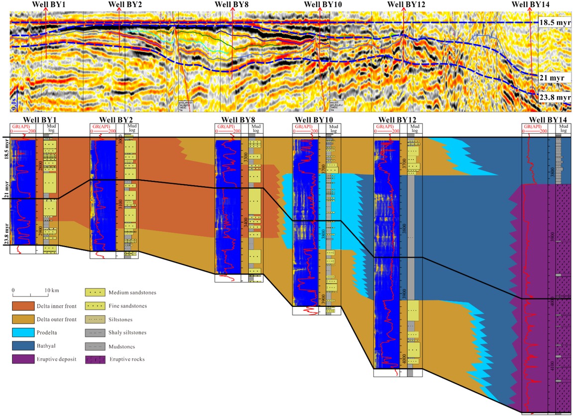
MESA result and microfacies of a correlation wells profile whose location can be found in Figure 2b. No MESA in Well BY14 for the eruptive deposit.
Obvious Milankovitch cycles found in Well BY1, BY3, BY8, BY10 and BY12.
In the stratigraphy, formation developed in the delta inner and outer front are thin than that in prodelta and bathyal, the average sedimentation rate of the former is less than that of the latter. For example, the average sedimentation rate of Lower Member of Zhujiang Formation in Well BY1 and Well BY12 is 0.0321 m/kyr and 0.0661 m/kyr respectively. However, the cyclical sedimentation rate estimated from Milankovitch cycles imply the inverse consequence, which is more accord with principles of sedimentology.
7 Conclusions
A method of Milankovitch cycles identification and sedimentation rate estimation is proposed based on Maximum Entropy Spectral Analysis using GR log in the petroleum boreholes, which could be divided into four stages. Choosing the calculating windows is the first stage. Calculating the frequency and generates the two-dimension frequency spectrum in short data sections is the second stage. Finding the potential Milankovitch cycles in the one-dimension frequency spectrum at each depth point serves as the third stage. Estimating the sedimentation rate of formation in the borehole sites is as the fourth stage. In one-dimension frequency spectrum of Milankovitch cycles, the wavelength of average amplitude spectrum peak would be matched to the ratio of the Milankovitch period. The Milankovitch period of the maximum amplitude spectrum is regarded as the dominant periodicity that controls the cyclicity, and the ratio of the wavelength and period offers an approximated cyclical accumulation rate of the depth.
The proposed approach has been applied to the Lower Member of Miocene Zhujiang Formation in north slope of Baiyun Sag, Pearl River Mouth Basin. The dominating cycles frequency in delta inner and outer front is mainly ~413.00 kyr and ~100.00 kyr, and the concluded cyclical sedimentation rate is about 0.1 m/kyr. In the mudstone of prodelta and bathyal, dominating cycles frequency is occasionally ~41.00 kyr and ~23.00 kyr, and the implied cyclical sedimentation rate is about 0.085 m/kyr. This method may be feasible and effective to identify Milankovitch cycles and estimate the cyclical sedimentation rate in the marine depositional environment and be useful to other geological researches.
Acknowledgement
The authors are thankful the anonymous reviewers for their constructive reviews on the manuscript, and the editors for carefully revising the manuscript. This research is financially supported by Hubei ProvincialNatural Science Foundation of China (No. 2019CFB343); Scientific Research Project of Hubei Provincial Department of Education (No. Q20181310); Open Fund of Key Laboratory of Exploration Technologies for Oil and Gas Resources (Yangtze University), Ministry of Education (No. K2018-21); National Naturel Science Foundation of China (No. 41772094); and National Science and Technology Major Project (No. 2016ZX05027-002-007).
References
[1] Milankovitch, M., Kanon der Erdbestrahlungen und seine Anwendung auf das Eiszeitenproblem, Royal Serbian Academy, Belgrade, 1941, 1-633.Suche in Google Scholar
[2] Maltezou F., Anderson R. N., Milankovitch cycles in electrical resistivity logs from the Toa Baja scientific drillhole, Puerto Rico, Geophysical Research Letters, 1991, 18(3): 517-520.10.1029/91GL00393Suche in Google Scholar
[3] Wu H. C., Zhang S. H., Sui S. W., Huang Q. H, Recognition of Milankovitch Cycles in the natural gamma-ray logging of Upper Cretaceous Terrestrial Strata in the Songliao Basin, Acta Geology Sinica, 2007, 81(6): 996-1001.10.1111/j.1755-6724.2007.tb01021.xSuche in Google Scholar
[4] Yu J. F., Sui F. G., Li Z. X., Liu H., Wang Y. L., Recognition of Milankovitch cycles in the stratigraphic record: application of the CWT and the FFT to well-log data, Journal of China University of Mining & Technology, 2008, 18: 594-598.10.1016/S1006-1266(08)60301-6Suche in Google Scholar
[5] Meyers S. R., Resolving Milankovitchian controversies: The Triassic Latemar Limestone and the Eocene Green River Formation, Geology, 2008, 36(4): 319-322.10.1130/G24423A.1Suche in Google Scholar
[6] Huang C. J., Hinnov L., Fischer A. G., Grippo A., Herbert T., Astronomical tuning of the Aptian Stage from Italian reference sections, Geology, 2010, 38(10): 899-902.10.1130/G31177.1Suche in Google Scholar
[7] Wu H. C., Zhang S. H., Feng Q. L., Jiang G. Q., Li H. Y., Yang T. S., Milankovitch and sub-Milankovitch cycles of the early Triassic Daye Formation, South China and their geochronological and paleoclimatic implications, Gondwana Research, 2012, 22:748-759.10.1016/j.gr.2011.12.003Suche in Google Scholar
[8] Meyers S. R., Sageman B. B., Quantification of deep-time orbital forcing by average spectral misfit, American Journal of Science, 2007, 307: 773-792.10.2475/05.2007.01Suche in Google Scholar
[9] Meyers S. R., Sageman B. B., Arthur M. A., Obliquity forcing of organic matter accumulation during Oceanic Anoxic Event 2, Paleoceanography, 2012, 27, PA3212.10.1029/2012PA002286Suche in Google Scholar
[10] Schulza M., Mudelsee M., Redfit: estimating red-noise spectra directly from unevenly spaced paleoclimatic time series, Computers & Geosciences, 2002, 28: 421-426.10.1016/S0098-3004(01)00044-9Suche in Google Scholar
[11] Meyers S. R., Sageman B. B., Hinnov L. A., Integrated quantitative stratigraphy of the Cenomanian-Turonian Bridge Creek Limestone Member using evolutive harmonic analysis and stratigraphic modeling, Journal of Sedimentary Research, 2001, 71(4): 628-644.10.1306/012401710628Suche in Google Scholar
[12] Meyers S. R., The evaluation of eccentricity-related amplitude modulation and bundling in paleoclimate data: An inverse approach for astrochronologic testing and time scale optimization, Paleoceanography, 2015, 2015PA002850.10.1002/2015PA002850Suche in Google Scholar
[13] Meyers S. R., Cyclostratigraphy and the problem of astrochronologic testing, Earth-Science Reviews, 2019, 190: 190-223.10.1016/j.earscirev.2018.11.015Suche in Google Scholar
[14] Zhang H. F., Zhang L. Y., Yao Y. M., Zhang S. P., Milankovitch cycles and sequence division and correlation of the Member 4 of the Shahejie Formation in the Dongying Depression, Shandong, Journal of Stratigraphy, 2008, 32(3): 279-284 (in Chinese with English abstract).Suche in Google Scholar
[15] Zhao Z. J., Chen X., Pan M., Wu X. N., Milankovitch Cycles in the Upper Ordovician Lianglitage Formation in the Tazhong-Bachu Area, Tarim Basin, Acta Geologica Sinica, 2010, 84(4): 518-536 (in Chinese with English abstract).Suche in Google Scholar
[16] Yuan X. X., Guo Y. H., Zhao Z. G., Shen Y. L., Cai J., Zhang H., Comparison of well-log sequence stratigraphic classification and correlation using Milankovitch cycles: Paleogene-Neogene strata of Xihu sag in East China Sea, Journal of China University of Mining & Technology, 2013, 42(5): 766-773 (in Chinese with English abstract).Suche in Google Scholar
[17] Gao D., Lin C. S., Hu M. Y., Huang L. L., Using spectral gamma ray log to recognize high-frequency sequences in carbonate strata: A case study from the Lianglitage Formation from Well T1 in Tazhong area, Tarim Basin, Acta Sedimentologica Sinica, 2016, 34(4): 707-715 (in Chinese with English abstract).Suche in Google Scholar
[18] Shi J. Y., Jin Z. J., Liu Q. Y., Huang Z. K., Recognition and division of high-resolution sequences based on the Milankovitch theory: A case study from the Middle Jurassic of Well Ary301 in the South Turgay Basin, Acta Sedimentologica Sinica, 2017, 35(2): 436-448 (in Chinese with English abstract).Suche in Google Scholar
[19] Pisias N. G., Mix A. C., Aliasing of the geologic record and the search for long-period Milankovitch cycles, Paleoceanography, 1988, 3(5): 613-619.10.1029/PA003i005p00613Suche in Google Scholar
[20] Wu H. C., Zhang S. H., Feng Q. L., Fang N. Q., Yang T. S., Li H. Y., Theoretical basis, research advancement and prospects of cyclostratigraphy, Earth Science-Journal of China University of Geosciences, 2011, 36(3): 409-428 (in Chinese with English abstract).Suche in Google Scholar
[21] Zou Z. Y., Huang C. J., Li M. S., Zhang Y., Climate change response to astronomical forcing during the Oligocene-Miocene transition in the equatorial Atlantic (ODP Site 926). Science China Earth Sciences, 2016, 59(8): 1665-1673.10.1007/s11430-016-5311-ySuche in Google Scholar
[22] Sang Y. F.,Wang Z. G., Liu C. G., Period identification in hydrologic time series using empirical mode decomposition and maximum entropy spectral analysis, Journal of Hydrology, 2012: 154-164.10.1016/j.jhydrol.2011.12.044Suche in Google Scholar
[23] Bennett K. D., Milankovitch cycles and their effects on species in ecological and evolutionary time, Paleobiology, 1990, 16(1): 11-21.10.1017/S0094837300009684Suche in Google Scholar
[24] Strasser A., Hilgen F. J., Heckel P. H., Cyclostratigraphy-concepts, definitions, and applications, Newsletters on Stratigraphy, 2006, 42(2): 75-114.10.1127/0078-0421/2006/0042-0075Suche in Google Scholar
[25] Laskar J., Robutel P., Joutel F., Gastineau M., Correia A. C. M., Levrard B., A long-term numerical solution for the insolation quantities of the Earth, Astronomy & Astrophysics, 2004, 428: 261-285.10.1051/0004-6361:20041335Suche in Google Scholar
[26] Berger, A., Loutre, M. F., Laskar, J., Stability of the astronomical frequencies over the Earth’s history for paleoclimate studies, Science, 1992, 255: 560-566.10.1126/science.255.5044.560Suche in Google Scholar PubMed
[27] Yu Y., Zhang C. M., Li S. H., Qin C. G., Geochemical characteristics of mudstone in the northern Baiyun depression and its provenance nature, Journal of China University of Mining & Technology, 2014, 43(4): 656-665 (in Chinese with English abstract).Suche in Google Scholar
[28] Mou W. W., Wang Q., Tian B., Hao L. W., Hu Z. J., The diagenetic facies logging response characteristics of medium-deep reservoirs in the north slope of Baiyun Sag,Pearl River Mouth Basin, Natural Gas Geoscience, 2017, 28(10): 1601-1612 (in Chinese with English abstract).Suche in Google Scholar
[29] Liu H. Y., Lin C. S., Zhang Z. T., Zhang B., Jiang J., Tian H. X., Liu H., Quaternary sequence stratigraphic evolution of the Pearl River Mouth Basin and controlling factors over depositional systems, Marine Geology & Quaternary Geology, 2019, 39(1): 25-37 (in Chinese with English abstract).Suche in Google Scholar
[30] Yu Y., Zhang C. M., Li S. H., Du J. Y., Huang Y. R., Wang L., Sedimentary sequence and favorable sand-body distribution in falling stage system tracts of the Miocene Zhujiang Formation in Pearl River Mouth Basin, Journal of Palaeogeography (Chinese Edition), 2018, 20(5): 841-854 (in Chinese with English abstract).Suche in Google Scholar
[31] Wu W., Liu W. Q., Lin C. S., Qin C. G., Shu L. F., Huang X. F., Sedimentary evolution of the Lower Zhujiang Group continental shelf edge in the North Slope of Baiyun Sag, Pearl River Mouth Basin, Acta Geologica Sinica, 2014, 88(9): 1719-1727 (in Chinese with English abstract).Suche in Google Scholar
[32] Lofi J., Voelker A. H. L., Ducassou E., Hernández-Molina F. J., Sierro F. J., Bahr A., Galvani A., Lourens L. J., Pardo-Igúzquiza E., Pezard P., Rodríguez-Tovar F. J., Williams T., Quaternary chronostratigraphic framework and sedimentary processes for the Gulf of Cadiz and Portuguese Contourite Depositional Systems derived from natural gamma ray records, Marine Geology, 2016, 377: 40-57.10.1016/j.margeo.2015.12.005Suche in Google Scholar
[33] Burg J. P., Maximum entropy spectral analysis. Proceedings of 37th Annual International Meeting, Society of Exploration Geophysics, Oklahoma City, USA, 1967.Suche in Google Scholar
[34] Bos A. D., Alternative interpretation of maximum entropy spectral analysis. IEEE Transactions on Information Theory, 1971, 17(4): 493-494.10.1109/TIT.1971.1054660Suche in Google Scholar
[35] Zhang X. H., Zhao Z. Y., Definition of Milankovitch cycles for Yangchang Formation of the Upper Triassic in Ordos Basin, Oil & Gas Geology, 2002, 23(4): 372-375 (in Chinese with English abstract).Suche in Google Scholar
© 2019 R. Yuan et al., published by De Gruyter
This work is licensed under the Creative Commons Attribution 4.0 Public License.
Artikel in diesem Heft
- Regular Articles
- 2D Seismic Interpretation of the Meyal Area, Northern Potwar Deform Zone, Potwar Basin, Pakistan
- A new method of lithologic identification and distribution characteristics of fine - grained sediments: A case study in southwest of Ordos Basin, China
- Modified Gompertz sigmoidal model removing fine-ending of grain-size distribution
- Diagenesis and its influence on reservoir quality and oil-water relative permeability: A case study in the Yanchang Formation Chang 8 tight sandstone oil reservoir, Ordos Basin, China
- Evaluation of AHRS algorithms for Foot-Mounted Inertial-based Indoor Navigation Systems
- Identification and evaluation of land use vulnerability in a coal mining area under the coupled human-environment
- Hydrocarbon Generation Potential of Chia Gara Formation in Three Selected Wells, Northern Iraq
- Source Analysis of Silicon and Uranium in uranium-rich shale in the Xiuwu Basin, Southern China
- Lithologic heterogeneity of lacustrine shale and its geological significance for shale hydrocarbon-a case study of Zhangjiatan Shale
- Characterization of soil permeability in the former Lake Texcoco, Mexico
- Detrital zircon trace elements from the Mesozoic Jiyuan Basin, central China and its implication on tectonic transition of the Qinling Orogenic Belt
- Turkey OpenStreetMap Dataset - Spatial Analysis of Development and Growth Proxies
- Morphological Changes of the Lower Ping and Chao Phraya Rivers, North and Central Thailand: Flood and Coastal Equilibrium Analyses
- Landscape Transformations in Rapidly Developing Peri-urban Areas of Accra, Ghana: Results of 30 years
- Division of shale sequences and prediction of the favorable shale gas intervals: an example of the Lower Cambrian of Yangtze Region in Xiuwu Basin
- Fractal characteristics of nanopores in lacustrine shales of the Triassic Yanchang Formation, Ordos Basin, NW China
- Selected components of geological structures and numerical modelling of slope stability
- Spatial data quality and uncertainty publication patterns and trends by bibliometric analysis
- Application of microstructure classification for the assessment of the variability of geological-engineering and pore space properties in clay soils
- Shear failure modes and AE characteristics of sandstone and marble fractures
- Ice Age theory: a correspondence between Milutin Milanković and Vojislav Mišković
- Are Serbian tourists worried? The effect of psychological factors on tourists’ behavior based on the perceived risk
- Real-Time Map Matching: A New Algorithm Integrating Spatio-Temporal Proximity and Improved Weighted Circle
- Characteristics and hysteresis of saturated-unsaturated seepage of soil landslides in the Three Gorges Reservoir Area, China
- Petrographical and geophysical investigation of the Ecca Group between Fort Beaufort and Grahamstown, in the Eastern Cape Province, South Africa
- Ecological risk assessment of geohazards in Natural World Heritage Sites: an empirical analysis of Bogda, Tianshan
- Integrated Subsurface Temperature Modeling beneath Mt. Lawu and Mt. Muriah in The Northeast Java Basin, Indonesia
- Go social for your own safety! Review of social networks use on natural disasters – case studies from worldwide
- Forestry Aridity Index in Vojvodina, North Serbia
- Natural Disasters vs Hotel Industry Resilience: An Exploratory Study among Hotel Managers from Europe
- Using Monarch Butterfly Optimization to Solve the Emergency Vehicle Routing Problem with Relief Materials in Sudden Disasters
- Potential influence of meteorological variables on forest fire risk in Serbia during the period 2000-2017
- Controlling factors on the geochemistry of Al-Shuaiba and Al-Mejarma coastal lagoons, Red Sea, Saudi Arabia
- The Influence of Kaolinite - Illite toward mechanical properties of Claystone
- Two critical books in the history of loess investigation: ‘Charakteristik der Felsarten’ by Karl Caesar von Leonhard and ‘Principles of Geology’ by Charles Lyell
- The Mechanism and Control Technology of Strong Strata Behavior in Extra-Thick Coal Seam Mining Influenced by Overlying Coal Pillar
- Shared Aerial Drone Videos — Prospects and Problems for Volunteered Geographic Information Research
- Stable isotopes of C and H in methane fermentation of agriculture substrates at different temperature conditions
- Prediction of Compression and Swelling Index Parameters of Quaternary Sediments from Index Tests at Mersin District
- Detection of old scattered windthrow using low cost resources. The case of Storm Xynthia in the Vosges Mountains, 28 February 2010
- Remediation of Copper and Zinc from wastewater by modified clay in Asir region southwest of Saudi Arabia
- Sedimentary facies of Paleogene lacustrine dolomicrite and implications for petroleum reservoirs in the southern Qianjiang Depression, China
- Correlation between ore particle flow pattern and velocity field through multiple drawpoints under the influence of a flexible barrier
- Atmospheric refractivity estimation from AIS signal power using the quantum-behaved particle swarm optimization algorithm
- A geophysical and hydro physico-chemical study of the contaminant impact of a solid waste landfill (swl) in King Williams’ Town, Eastern Cape, South Africa
- Landscape characterization using photographs from crowdsourced platforms: content analysis of social media photographs
- A Study on Transient Electromagnetic Interpretation Method Based on the Seismic Wave Impedance Inversion Model
- Stratigraphy of Architectural Elements of a Buried Monogenetic Volcanic System
- Variable secondary porosity modeling of carbonate rocks based on μ-CT images
- Traditional versus modern settlement on torrential alluvial fans considering the danger of debris flows: a case study of the Upper Sava Valley (NW Slovenia)
- The Influence of Gangue Particle size and Gangue Feeding Rate on Safety and Service Life of the Suspended Buffer’s Spring
- Research on the Transition Section Length of the Mixed Workface Using Gangue Backfilling Method and Caving Method
- Rainfall erosivity and extreme precipitation in the Pannonian basin
- Structure of the Sediment and Crust in the Northeast North China Craton from Improved Sequential H-k Stacking Method
- Planning Activities Improvements Responding Local Interests Change through Participatory Approach
- GIS-based landslide susceptibility mapping using bivariate statistical methods in North-western Tunisia
- Uncertainty based multi-step seismic analysis for near-surface imaging
- Deformation monitoring and prediction for residential areas in the Panji mining area based on an InSAR time series analysis and the GM-SVR model
- Statistical and expert-based landslide susceptibility modeling on a national scale applied to North Macedonia
- Natural hazards and their impact on rural settlements in NE Romania – A cartographical approach
- Rock fracture initiation and propagation by mechanical and hydraulic impact
- Influence of Rapid Transit on Accessibility Pattern and Economic Linkage at Urban Agglomeration Scale in China
- Near Infrared Spectroscopic Study of Trioctahedral Chlorites and Its Remote Sensing Application
- Problems with collapsible soils: Particle types and inter-particle bonding
- Unification of data from various seismic catalogues to study seismic activity in the Carpathians Mountain arc
- Quality assessment of DEM derived from topographic maps for geomorphometric purposes
- Remote Sensing Monitoring of Soil Moisture in the Daliuta Coal Mine Based on SPOT 5/6 and Worldview-2
- Utilizing Maximum Entropy Spectral Analysis (MESA) to identify Milankovitch cycles in Lower Member of Miocene Zhujiang Formation in north slope of Baiyun Sag, Pearl River Mouth Basin, South China Sea
- Stability Analysis of a Slurry Trench in Cohesive-Frictional Soils
- Integrating Landsat 7 and 8 data to improve basalt formation classification: A case study at Buon Ma Thuot region, Central Highland, Vietnam
- Assessment of the hydrocarbon potentiality of the Late Jurassic formations of NW Iraq: A case study based on TOC and Rock-Eval pyrolysis in selected oil-wells
- Rare earth element geochemistry of sediments from the southern Okinawa Trough since 3 ka: Implications for river-sea processes and sediment source
- Effect of gas adsorption-induced pore radius and effective stress on shale gas permeability in slip flow: New Insights
- Development of the Narva-Jõesuu beach, mineral composition of beach deposits and destruction of the pier, southeastern coast of the Gulf of Finland
- Selecting fracturing interval for the exploitation of tight oil reservoirs from logs: a case study
- A comprehensive scheme for lithological mapping using Sentinel-2A and ASTER GDEM in weathered and vegetated coastal zone, Southern China
- Sedimentary model of K-Successions Sandstones in H21 Area of Huizhou Depression, Pearl River Mouth Basin, South China Sea
- A non-uniform dip slip formula to calculate the coseismic deformation: Case study of Tohoku Mw9.0 Earthquake
- Decision trees in environmental justice research — a case study on the floods of 2001 and 2010 in Hungary
- The Impacts of Climate Change on Maximum Daily Discharge in the Payab Jamash Watershed, Iran
- Mass tourism in protected areas – underestimated threat? Polish National Parks case study
- Decadal variations of total organic carbon production in the inner-shelf of the South China Sea and East China Sea
- Hydrogeothermal potentials of Rogozna mountain and possibility of their valorization
- Postglacial talus slope development imaged by the ERT method: comparison of slopes from SW Spitsbergen, Norway and Tatra Mountains, Poland
- Seismotectonics of Malatya Fault, Eastern Turkey
- Investigating of soil features and landslide risk in Western-Atakent (İstanbul) using resistivity, MASW, Microtremor and boreholes methods
- Assessment of Aquifer Vulnerability Using Integrated Geophysical Approach in Weathered Terrains of South China
- An integrated analysis of mineralogical and microstructural characteristics and petrophysical properties of carbonate rocks in the lower Indus Basin, Pakistan
- Applicability of Hydrological Models for Flash Flood Simulation in Small Catchments of Hilly Area in China
- Heterogeneity analysis of shale reservoir based on multi-stage pumping data