Source Analysis of Silicon and Uranium in uranium-rich shale in the Xiuwu Basin, Southern China
-
Zhuo Li
 ,
Yan Song
,
Xiaoxue Liu
,
Zhenxue Jiang
,
Shu Jiang
,
Ming Wen
,
Yan Song
,
Xiaoxue Liu
,
Zhenxue Jiang
,
Shu Jiang
,
Ming Wen

Abstract
Uranium deposits are crucial resources for the development of the nuclear energy. Among known sources of uranium, the uranium-rich shales have recently obtained significance. In this paper, the Lower Cambrian Wangyinpu Formation shale in the Xiuwu Basin, southern China, has been studied using a combination of techniques including element analysis (Al, Fe, and Mn), δ30Si silicon isotopic analysis, δ18O oxygen isotopic analysis, study of core samples. It has been observed that significant hydrothermal activity occurred in the Xiuwu Basin during the Early Cambrian period. The results show that 20%–40% of the silicon in most of the sections of the Lower Cambrian Wangyinpu Formation were inherited from the hydrothermal fluids, with temperatures ranging between 75∘C and 102∘C. It is concluded that more than 90% of the uranium in most of the sections of the Lower Cambrian Wangyinpu shale was derived from submarine hydrothermal fluids, while less than 10% from the terrigenous detritus. The enrichment of uranium in the basin was observed in the Middle-Upper part of the Wangyinpu Formation and the geological resources estimated to a tune of ~4.9×10³ t. In this paper, we proposed a model for silicon and uranium enrichment in the Lower Cambrian shale controlled by hydrothermal activity in the Xiuwu Basin. This model also provides a scientific rationale for uranium further exploration and exploitation of the uranium resource.
1 Introduction
Uranium deposits are important strategic and energy mineral resources as well as basic raw materials for the nuclear industry [1, 2, 3, 4, 5]. Due to increasing domestic demand, China needs to generate more power to propel its economic development. Nuclear power is favored because of it is clean and efficient. In 2007, China proposed the goal of building 40 million kilowatts of nuclear power by 2020 and maintaining 18 million kilowatts of nuclear power under construction. According to estimates of the speed and scale of nuclear power development, a considerable amount of uranium resources is needed to meet future development goals. China has abundant uranium resources scattered in many types of deposits including granite-, volcanic-, sandstone-, and shale-hosted deposits [6, 7]. The shale-type uranium deposit is one of the earliest types of industrial uranium deposits that were discovered. In 1893, the world’s first shale-type uranium deposit was discovered in Sweden. After 1940s, shale-type uranium emerged as an important type of uranium deposit for the mining industry during the peak of uranium exploration [8, 9]. Subsequently, several shale-type uranium deposits were discovered in Sweden, the United States, Norway, Germany, Russia, Kazakhstan, Uzbekistan, Germany, South Korea and China [10].
Uranium-rich shale is rich in U and Si. There is abundant uranium in the shales of the Lower Cambrian Wangy-inpu Formation in Xiuwu Basin; however, determining source of this uranium is still not known [11, 12, 13]. Previous studies were focused on understanding the source of silicon, in this paper we are constraining the source of uranium in shale. It is believed that some special sedimentary structures and minerals can be formed by seafloor hydrothermal activity [14, 15, 16, 17]. For special sedimentary structures, there are scour surface, columnar structures, vein structures, contraction-like structures, horizontal laminated bed structures and nodules. In addition, special minerals mainly refer to hydrothermal silica and uranium. Holdaway and Clayton (1982) used excess siliceous minerals (i.e, siliceous minerals beyond the normal terrigenous clastic sources) and proposed a method to quantitatively calculate excess siliceous mineral [18]. Wedepohl (1971), Adachi et al (1986) and Yamamoto (1987) proposed a method using the Al-Fe-Mn ternary plot to determine hydrothermal versus biogenic origin of silicate minerals [19, 20, 21]. Whereas, Bostrom et al (1973) and Douthitt et al (1982) proposed a method of determining origin of siliceous mineral using silicon isotopes [22, 23]. Furthermore, Savin et al (1970) and Knauthand Epstein (1976) proposed a method for calculating hydrothermal temperatures suing oxygen isotopes [24, 25]; Taylor and McLennan(1985) and Algeo et al (2011) devised a method for calculating the elemental composition from non-terrestrial debris based on post-Archean Australian shale (PAAS) standard values [26, 27]. In this paper we assess the relationship between silicon and uranium and characterize the source of uranium in the Lower Cambrian shale of the Xiuwu Basin. We further propose the enrichment model for silicon element and uranium in the Lower Cambrian shale and its utility for exploration and mining of uranium in the Xiuwu Basin.
2 Geological settings
2.1 Sedimentary and stratigraphic characteristics
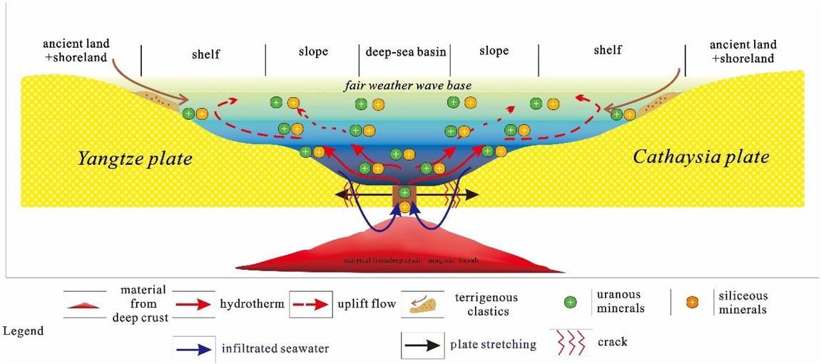
In the early period of the Early Cambrian, sedimentary environments of the Yangtze Plate from northwest to southeast were ancient land, shallow shelf, deep shelf, continental slope, and oceanic basin (Figure 1);whereas those from the Cathaysian Plate from northwest to southeast were ocean basin, continental slope, deep shelf, shallow shelf, and ancient land [28, 29]. The environment at the junction of the two plates was an ocean, with deep water gradually shallowing to both sides of the ancient land and the Xiuwu Basin was in a deep anoxic reducing environment [28, 29].
![Figure 1 The sedimentary characteristics of the Yangtze Plate and the Cathaysian Plate during the Early Cambrian in South China. The hydrothermal activity in the Early Cambrian came from the junction of the Yangtze Plate and the Cathaysian Plate. And the Jiangye-1 well in Xiuwu Basin was close to the junction of the plate, so the Lower Cambrian shale in Jiangye-1 well was affected by the hydrothermal activity during sedimentation. Modified after references [2829].](/document/doi/10.1515/geo-2019-0008/asset/graphic/j_geo-2019-0008_fig_001.jpg)
The sedimentary characteristics of the Yangtze Plate and the Cathaysian Plate during the Early Cambrian in South China. The hydrothermal activity in the Early Cambrian came from the junction of the Yangtze Plate and the Cathaysian Plate. And the Jiangye-1 well in Xiuwu Basin was close to the junction of the plate, so the Lower Cambrian shale in Jiangye-1 well was affected by the hydrothermal activity during sedimentation. Modified after references [2829].
One of the goals of this paper is to describe a set of strata that was widely deposited on the Yangtze Plate and the Cathaysian Plate during the Early Cambrian. Due to its vast distribution, it has been given different names in different regions, for e.g in the Lower Yangtze region, it is known as Wangyinpu Formation. It is characterized by a set of black-dark gray organic-rich shale deposited in the Early Cambrian, which is one of the key exploration targets for shale gas in China.
2.2 Tectonic characteristics
During the Sinian period, the Xiuwu Basinwas an intracratonic basin. A marine regression at the end of the Sinian period formed the Piyuancun Formation, which was dominated by siliceous dolomite. Subsequently, a large-scale transgression occurred in the Early Cambrian, forming the Wangyinpu Formation black shale, which was rich in organic matter and had a thickness of 45–60 m. After that, the sea level gradually became shallower, and the sedimentary environment of the Guanyintang Formation transitioned into a shallow water shelf [30]. The sedimentary system shifted from the Early Cambrian clastic sedimentary system into the Middle-Late Cambrian carbonate sedimentary system before transitioning back into a clastic sedimentary system in the Early Middle Ordovician period [31]. Due to plate collision in the Late Ordovician-Early Silurian, the study area was squeezed to form a deep-water environment. During the Middle Silurian period, the water body gradually became shallower, and the study area was uplifted to the ancient land surface in the Late Silurian period [32, 33, 34, 35, 36, 37].
3 Samples, experiments and data sources
3.1 Mineral composition analysis
In this paper, 20 core samples were taken from the Lower Cambrian Wangyinpu Formation in Jiangye-1well, and the mineral composition was analyzed by ZJ207 Bruker D8 advance X-ray diffraction instrument.
3.2 Elemental log data
This paper included elemental log data (U, Si, Al, and Th) from two wells provided by the Schlumberger Corp with a data point every 0.125 m of depth.
3.3 Elemental analysis
In this study, 87 core samples of the Cambrian Wangy-inpu Formation from the Jiangye-1 well were taken approximately 0.5 m–1 m apart. The elemental analysis of core samples from the Jiangye-1 well was carried out by X-ray fluorescence spectrometry (Axios-MAX), and the mass percentage of Al, Fe and Mn was obtained.
3.4 Analysis of silicon and oxygen isotopes
Three core samples from the Lower Cambrian Wangyinpu Formation in Jiangye-1 well were selected for the measurement of silicon and oxygen isotopes using the MAT-251EM mass spectrometer in Nanjing University. The number and depth of samples are shown in Table 1. The silicon isotope analysis method is the SiF4 method, in which the samples were crushed to 200 mesh, calcined, their organic matter was removed, and then they were soaked in HCl to remove siderite and other sulfides. The purified samples (SiO2) were reacted with BrF5 at a constant temperature of 550∘C to form SiF4 gas. The purified SiF4 gas obtained through the liquid N2 trap purification process was measured by mass spectrometry. Based on international standard NBS-28, the analytical error limitation was ±0.1%ffl. The method of oxygen isotope analysis was also based on the BrF4 method measured by mass spectrometry using the international standard VSMOW, the analytical error limitation was ±0.2%ffl. In addition to the silicon and oxygen isotope measurements of the three samples carried out in this study, the silicon isotope and oxygen isotope data of the Zhangjiajie profile of Hunan Province having same sedimentary environment were used for comparison.38
The number, depth, and formation of core sample of silicon isotope and oxygen isotope experiments in Jiangye-1 well. See Figure 1 and 2 for the well location.
| Number | Well | Depth (m) | Formation |
|---|---|---|---|
| 1 | Jiangye1 | 2629 | Wangyinpu |
| 2 | Jiangye1 | 2645 | Wangyinpu |
| 3 | Jiangye1 | 2663 | Wangyinpu |
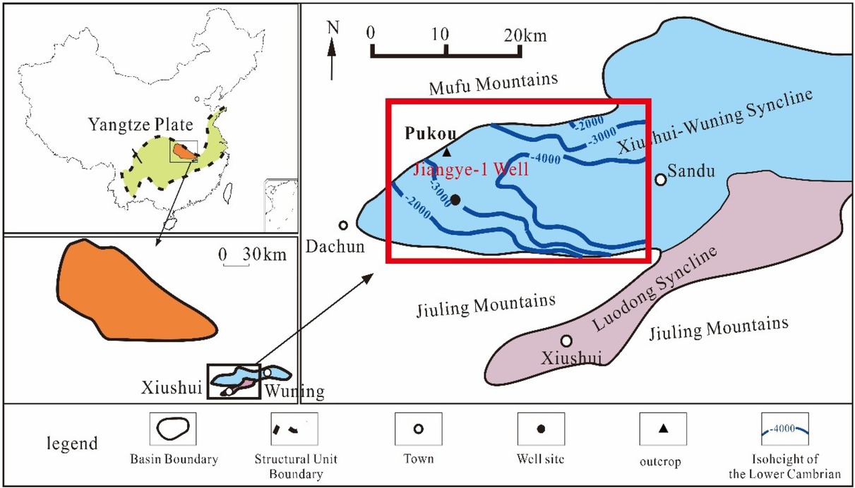
The Xiuwu Basin is located in the Lower Yangtze area on the southeastern side of the Jianghan Basin. It consists of the Xiushui-Wu Ning and Luodong synclines. The study area is located on the west side of the Xiushui-Wuning syncline, in which the Jiangye-1 well is drilled.
3.5 Cores and field profile observation
In this study, core samples (total 72m thick) in the Lower Cambrian Wangyinpu Formation along with its overlying and underlying strata were logged in detail. Additionally, the Pukou profile (Lower Cambrian outcrop) in the northern side of the Xiuwu Basin was also recorded in detail.
4 Results and Discussion
4.1 Redox environment during the sedimentary period of the Lower Cambrian Wangyinpu Formation in Jiangye-1 well
Various methods have been used to decipher sedimentary environments including geochemical proxies. Among these, U/Th ratio had been effectively used to characterize the sedimentary redox conditions [19, 20, 21]. Generally speaking, U/Th > 1.25 represents anoxic environment, U/Th ratio between 0.75 and 1.25 represents dysoxic environment, and U/Th < 0.75 represents oxidizing environment. As can be seen from Figure 3, the redox index (U/Th ratio) of the Lower Cambrian Wangyinpu Formation in Jiangye-1 well during the shale deposition period is very high ( 4-18), which indicates that a strong anoxic environment prevailed at the time of deposition.
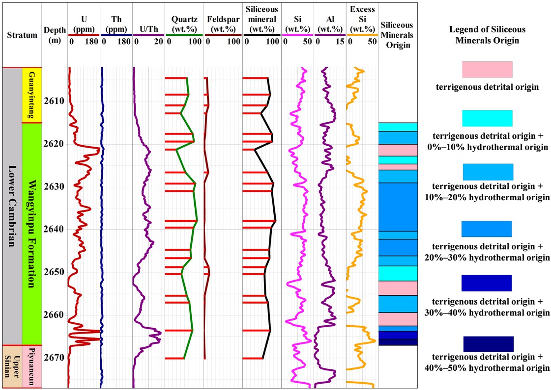
Determination of redox environment and calculation results of source of the excess siliceous mineral in Wangyinpu Formation of Cambrian during sedimentary period. In layers where excess siliceous mineral is present, the excess siliceous mineral in half of the layers is between 20% and 30%, and the excess siliceous mineral in some layers is between 30% and 40%, even reaching 40% to 50%. See Figure 1 for the well location.
4.2 Source analysis of silicon in the Lower Cambrian shale
Using Si and Al log data from Jiangye-1 well, the excess siliceous mineral from a non-terrigenous clastic source was calculated, and the excess silicate minerals were identified with an Al-Fe-Mn ternary plot. Further, silicon isotope analyses were used to estimate the hydrothermal activity in the deposition of shale and temperature of the hydrothermal fluid was calculated using oxygen isotopes, as discussed below.
4.2.1 An Al-Fe-Mn ternary plot to determine the source of silicate minerals
In shale, the silicon is concentrated in silicate minerals, namely, quartz and feldspar, more so in the form of pure quartz (SiO2).The common sources of silicon are: terrestrial detrital deposits, hydrothermal silicon, and biogenic silicon [22, 39, 40]. During the hydrothermal activity, sea-water reaches deeper parts of seabed through fissures and faults and exchange their chemical components with the crustal rocks. The infiltrated seawater gets heated by the heat supplied by underground magma chambers or extruded basalts, and manifest them in the form of submarine hot springs. The trace elements including most metallic elements in the hydrothermal are therefore quite different from those present in the ordinary seawater [41, 42].
Excess silicates (abbreviated as Siex) refers to those, excluding normal terrigenous clastic deposits. These were calculated by using following formula:
Sis refers to silicon in the sample, Als is the aluminum element in the sample, and (Si/Al)bg is 3.11, which is based on the average composition of the shale [18]. According to Si and Al log curves provided by Schlumberger Corp, this formula has been used to calculate the excess siliceous mineral from the Jiangye-1 well in the Lower Cambrian Wangyinpu Formation, and the results are shown in Figure 3. It was observed that there is excess silica in most layers of the Wangyinpu Formation. In the layers where excess silica is present, about half of the layers have Siex between 20% and 30%, and in some layers, Siex is between 30% and 40%, occasionally reaching 40% to 50%.
Wedepohl (1971), Adachi et al (1986) and Yamamoto (1987) proposed a method using the Al-Fe-Mn ternary plot to determine whether the excess silica is derived from hydrothermal or biogenic sources [19, 20, 21]. As shown in Figure 4, the data fall within the hydrothermal field of the ternary plot, indicating that the excess silica is hydrothermal origin.
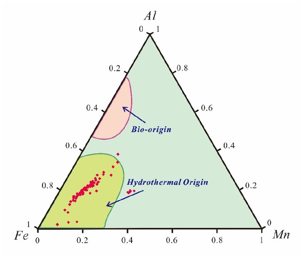
Through the Al-Fe-Mn ternary plot analysis, it is found that siliceous mineral from the Lower Cambrian Wangyinpu Formation in the Jiangye-1 well contain excess siliceous mineral, which is derived from hydrothermal origin. See Figure 1 for the well location. I is the bio-origin, and II is the hydrothermal origin.
4.2.2 The silicon and oxygen isotopes
The δ30Si value in siliceous rocks has regular changes in different sedimentary environments. Therefore, the δ30Si value can be considered as an important index for judging the origin of silica and its depositional environment. Generally, the δ30Si value of quartz from hydrothermal source is very small, ranging from −1.5%ffl to +0.8%ffl; the δ30Si value of authigenic quartz in groundwater ranges from +1.1%ffl to +1.4%ffl; the δ30Si value of quartz in metasomatic siliceous rock is higher, ranging from +2.4%ffl to +3.4%ffl [22, 23, 43].
In this study, the δ30Si values of the three core samples from the Lower Cambrian Wangyinpu Formation shale in the Xiuwu Basin, Jiangxi Province are +0.1%ffl, −0.3%ffl, −0.6%ffl respectively, as shown in Table 2 (the samples numbered from 1 to 3). Previous δ30Si analysis of the Lower Cambrian shale in the Zhangjiajie, Hunan Province, showed that values were −0.3%ffl, −0.4%ffl, −0.5%ffl respectively [38], as shown in Table 2 (The samples numbered from 4 to 6). The δ30Si values of the six samples are all in the range of −1.5%ffl – +0.8%ffl, which indicates that in the Early Cambrian, the sedimentary environment was an oceanic basin affected by hydrothermal activity between the Yangtze Plate and the Cathaysian Plate.
Silicon and oxygen isotope composition of the Lower Cambrian shale and temperature of the sedimentary environment calculated from empirical formulas. The δ30Si and δ18O values of No. 1-3 are from the Lower Cambrian shale in Jiangye-1 of Xiuwu Basin, Jiangxi Province. The δ30Si and δ18O values of No. 4-6 are from the Lower Cambrian shale of Zhangjiajie, Hunan Province [38].
| Sample Number | δ30Si (%fh) | δ18O (%fh) | The temperature calculated according to formula (1) ∘C | The temperature calculated according to formula (2) ∘C |
|---|---|---|---|---|
| 1 | 0.1 | 22.2 | 75 | 77 |
| 2 | −0.3 | 18.6 | 102 | 92 |
| 3 | −0.6 | 21 | 83 | 82 |
| 4 | −0.4 | 19.1 | 98 | 90 |
| 5 | −0.5 | 21.6 | 79 | 80 |
| 6 | −0.3 | 20.9 | 84 | 83 |
The oxygen isotope composition of shale is an important index for studying the genesis of silica [24, 25]. Quartz with different origins has different δ18O values. The δ18O value of igneous quartz ranges from 8.3%ffl to 11.2%ffl, with an average of 9%ffl; the δ18O value of metamorphic quartz ranges from 11.2%ffl to 16.4%ffl, with an average of 13%ffl–14%ffl; and the δ18O value of hydrothermal quartz ranges from 12.2%ffl to 23.6%ffl [24, 25]. For modern beach sand quartz, δ18O value ranges from 10.3%ffl to 12.5%ffl,
with an average of 12%ffl. According to the experimental results, the δ18O values of the three core samples from the Lower Cambrian Wangyinpu Shale in the Xiuwu Basin, Jiangxi Province, are +18.6%ffl, +21%ffl, +22.2%ffl respectively (Table 2). Jiang and Li (2005) performed a δ18O analysis of the Lower Cambrian shale in Zhangjiajie, Hunan Province, the sedimentary environment of which was also an ocean basin in the Early Cambrian period, with values of +19.1%ffl, +20.9%ffl, and +21.6%ffl (Table 2) [38]. The results show that the oxygen isotope of the target layer in the study area is significantly different from that of igneous quartz, metamorphic quartz, and modern beach sand quartz and is distributed within the range of δ18O value of hydrothermal quartz, reiterating hydrothermal origin for excess silica.
The oxygen isotope composition of silicate rocks can be used to calculate the temperature of the ancient ocean [25]. The method for calculation of temperature is shown in the following two empirical formulas:
δ18O (shale) is the oxygen isotope composition of shale; δ18O (seawater) is the oxygen isotope composition of the sedimentary medium (seawater). In formula (1), T is the thermodynamic temperature. In the above two formulas, the oxygen isotope composition of the sedimentary medium is unknown, but previous studies have shown that the oxygen isotope composition of seawater does not change much from ancient to modern. Therefore, it is assumed that the oxygen isotopic composition of ancient sea-water is same as that of modern seawater, 0% [25, 44].
Based on above assumptions, the samples from the target layer in the study area (the samples numbered from 1 to 3) were used to calculate temperature with formula (1). The temperature of hydrothermal fluids in the Early Cambrian ancient sea in the study area (the samples numbered from 1 to 3) ranged from 75∘C to 102∘C. The samples from Zhangjiajie, Hunan Province, within the same sedimentary environment (the samples numbered from 4 to 6) revealed a temperature of 79∘C to 98∘C for the hydrothermal fluids in the Early Cambrian ancient sea. According to formula (2), the temperature of hydrothermal fluids in the Early Cambrian ancient sea in the study area (samples 1-3) varied from 77∘C to 92∘C. The samples from Zhangjiajie, Hunan Province, within the same sedimentary environment (samples 4-6) revealed temperatures of the hydrothermal fluids in the Early Cambrian ancient sea varied from 80∘Cto 90∘C. Since the samples used in this experiment can be of uncertain origin, there could be some contribution of excess silica contributed by the terrigenous deposits in addition to hydrothermal silica. However, it is clear that the temperature of ancient seawater was still much higher. Bearing et al (2018) recently proposed that the seawater temperature near the equator during the Early Cambrian was 35∘C–45∘C [44]. According oxygen isotope data, the calculated temperature of the seawater in the Lower Cambrian ocean in the study area (75∘C to 102∘C) was much higher than that near the equator (35∘C–45∘C), indicating that the ocean between the Yangtze Plate and the Cathaysian Plate in the Early Cambrian was greatly affected by exhalation of hydrothermal solutions.
4.2.3 Special sedimentary structures
In the deep sea where the sedimentary environment is relatively low-energy, shale with horizontal bedding and massive bedding will develop [45, 46, 47, 48]. If hydrothermal activity exists in the seabed, due to the fast flow rate and large flow volume, it will be easy to form special sedimentary structures in the relatively soft seabed sediments, thus providing a basis for identifying hydrothermal activity.
Scour surface
Scour surface refers to the uneven sedimentary surface caused by scouring the underlying sediments because of increased water flow rate, which indicates that there is a strong scour process after the underlying strata deposition [17]. The top of the consolidated and semi-consolidated deep seabed sediments will become an uneven erosional surface due to the scour of hydrothermal activity. Above the scour surface, when the sediments get deposited again, fragments and gravel from the underlying strata, which are washed down are often deposited in the gullies and grooves formed by scour (Figure 5A) The scour surface is relatively smooth and undulating, which indicates that it formed by submarine hydrothermal fluids scouring.
Columnar structures
At the bottom of the Lower Cambrian Wangyinpu Formation, in addition to the development of the scour surface structures, a large number of columnar barite bodies were formed (Figure 5B) The columnar body is composed of barite that is usually ~1 m in length and ~15 cm in diameter. The formation of columnar barite might be caused by quick exhalation of high density BaSO4. Due to the high density and quick exhalation, it crystallized without mixing with seawater.
Vein structures
A large number of veined barite bodies were found in the Lower Cambrian Wangyinpu shale. This is because when the seabed sediments had not been consolidated, they were invaded by hydrothermal fluids rich in BaSO4, causing strong deformation of the shale (Figure 5C) These structures were formed because the cracks were filled with barite.
Contraction-like structures
Some dry crack-like structures were often found on carbonaceous shale from the barite ore floor (Figure 5D) The cracks were filled with carbonaceous shale containing barite that may be formed by hydrothermal fluids filling cracks in the underlying bed.
Horizontal laminated bed structures
Horizontal laminated bed structures of organic shale and barite layers can be formed in the shale (Figure 5E) The sedimentary structures were well developed in hydrothermal sedimentary rocks, particularly in the late stage of hydrothermal venting-flowing process or at the periphery of the vents.
Nodules
Barite nodules were products formed by a small amount of exhalative material at the end of the exhalation of fluids rich in BaSO4. Barite nodules generally were ~5 cm in diameter and ~2 cm in height and were densely packed (Figure 5F)
The Lower Cambrian Wangyinpu Formation displayed a variety of sedimentary structures: scour surface, columnar structures, vein structures, contraction-like structures, horizontal laminated bed structures, and nodules, and all constituted a typical structural assemblage resulting from hydrothermal exhalation, indicating the process of submarine exhalation from beginning to end.
From above analysis, hydrothermal activity was relatively developed at the junction of the Early Cambrian Cathaysian Plate and the Yangtze Plate due to extension between the two plates. As a result, silicon in shale was not only derived from terrestrial detritus, but also contained deep crustal materials produced by the hydrothermal activity.
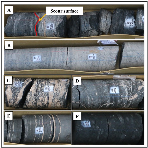
Sedimentary structures in shale in the Lower Cambrian Wangyinpu Formation from the Jiangye-1 well. A: Scour surface, B: Columnar structures; C: Vein structures; D: Contraction-like structures; E: Horizontal laminated bed structures; F: Nodules. See Figure 1 for the well location.
4.3 Analysis of uranium source
In seawater, the concentration of uranium was very less. Similar to silicon, uranium in oceanic water mainly also comes from two sources: terrigenous and non-terrigenous source. Uranium from non-terrigenous source is called excess uranium (UXS), and its content can be calculated by the total content of uranium (Us) minus the estimated content [Als(U/Al)PAAS] derived from terrigenous detritus. The formula is expressed as given below:
Where, Us – total content of U in shale sample, Als–total content of Al in the shale sample. The PAAS is the chosen standard shale in Australia [26]. The (U/Al)PAAS is the ratio of the two elements in the shale, specifically, 3.67×10⁻⁵, and the UXS is the excess value of uranium. If UXS is positive, it indicates that there is a uranium component of non-terrigenous origin. If UXS is negative, it indicates that the uranium in the sample is from terrigenous detritus. The UXS value for current samples is shown in Figure 6. The results indicate that there is uranium of non-terrigenous origin in most layers of the Wangyinpu Shale, and in the layers containing non-terrigenous uranium, the proportion of uranium from a non-terrigenous source is greater than 90%. Aluminum was related to terrestrial debris, but the uranium from non-hydrothermal origin was also related to other factors. Therefore there was an error in the calculation of formula.

Results of excess uranium UXS (uranium element from non-terrigenous detrital origin) calculations in the Cambrian Wangyinpu Formation in downhole Jiangye-1 See Figure 1 for the well location.
Hydrothermal activity can introduce various elements into sedimentary materials, including metals such as Na, Mg, Ca, Fe, Mn, Zn, Cu, and K; radioactive elements such as U and Th; and non-metallic elements such as Si, S, and P [49]. The organic matter has great adsorption capacity in adsorbing uranium from seawater, which catalyzes uranium deposition. A correlation between excess uranium and excess silica in the Wangyinpu shale is shown in Figure 7, which shows a significant positive correlation. It appears that since the excess silica was derived from hydrothermal fluids, excess uranium might also be derived from the hydrothermal fluids. By this analogy, more than 90% of the uranium in most of the Wangyinpu shale was derived from the hydrothermal activity in Xiuwu Basin during the Early Cambrian period, leaving less than 10% U contribution from the terrigenous detritus.
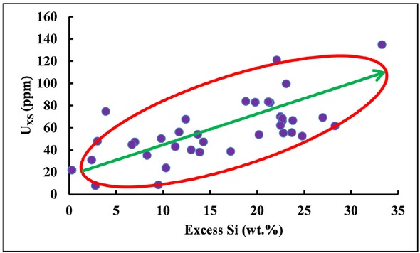
Correlation analysis of excess uranium (UXS) and excess siliceous material in the Lower Cambrian Wangyinpu Formation from Jiangye-1 well. See Figure 1 for the well location.
Figure 6 shows the uranium is concentrated in the Middle-Upper part of the Wangyinpu Formation. The continuous thickness with greater than 50 ppm uranium is 27 m, from 2620 mto 2647 m. The total thickness with greater than 100 ppm uranium is 9 m, from 2620 mto 2690 m. The potential area of uranium resources in Xiuwu Basin is 840 km2, and the geological uranium resources in Xiuwu Basin are calculated to be 4.9 × 10³ t, which is a good prospect for uranium exploration.
4.4 Mode of enrichment of silicon and uranium in Wangyinpu shale
In the above discussion, the mechanism of silica and uranium enrichment in the Wangyinpu shale in the Xiuwu Basin is summarized, as shown in Figure 8. In the Early Cambrian period, due to the continuous activity of the super mantle plume, the Gondwana began to rift, and the Yangtze Plate and the Cathaysian Plate at the edge of the Gondwana underwent extension. The seawater was deep and highly reductive. Oceanic water penetrated into the deep seabed crust through the extensional faults between the two plates, and the infiltrated seawater was heated by magma and rose after substantial chemical exchange. Subsequently, the oceanic water escaped from the seabed in the form of submarine fountains. The hydrothermal fluids had temperatures as high as 75∘C–102∘C and were enriched in silicon and uranium. In addition, terrigenous detritus also carried some silicon and uranium, which were co-deposited from the two sources to form uranium-rich shale. Approximately 20%–40% of the silica in the shale came from seabed hydrothermal fluids, and the rest of it came from terrigenous debris; whereas more than 90% of the uranium element came from seabed hydrothermal fluids, and less than 10% came from terrigenous detritus.
The model of the source of silicon element and uranium element in the Xiuwu Basin during Early Cambrian. 20%–40% of silicon comes from seafloor hydrothermal fluids, the rest comes from terrigenous detritus; more than 90% of uranium comes from seafloor hydrothermal fluids, less than 10% from terrigenous detritus.
5 Conclusions
In most parts of the Lower Cambrian Wangyinpu Formation shale in the Yangtze region, ~20%–40% of the silica in the shale was contributed by the hydrothermal fluids having temperatures of 75∘C–102∘C.
Sedimentary structures typically formed in the hydrothermal environment, such as scour surfaces, columnar structures, vein structures, contraction-like structures, horizontal laminated bed structures, and nodules were observed in the Wangyinpu Formation shale provide conclusive evidence for the wide spread hydrothermal activity in the studied area.
More than 90% of the uranium in most of the layers of the Lower Cambrian Wangyinpu Formation was derived from submarine hydrothermal fluids, while less than 10% was from terrigenous detritus.
Uranium was concentrated in the Middle-Upper part of the Lower Cambrian Wangyinpu Formation in the Xiuwu Basin. The geological uranium resources were 4.9×10³ t, which was a good prospect for exploration. The uranium enrichment model for the uranium-rich shale in the Xiuwu Basin proposed here indicates extensional tectonics was responsible for the uranium enrichment through hydrothermal solutions.
Acknowledgement
This study was supported by the National Science and Technology Major Projects (No. 2017ZX05035-002), the Science Foundation of the Ministry of Land and Resources of China (No.12120114046701), the National Natural Science Foundation of China (No. 41472112 and No. 41728004) and open funds from the Sinopec Key Laboratory of Shale Oil/Gas Exploration and Production Technology. We sincerely appreciate all anonymous reviewers and the handling editor for their critical comments and constructive suggestions.
References
[1] Boyle, D.R., 1982. The information of basal-type urnium deposits in South Central Britishi Columbia. Economic Geology 77:1176–1209.10.2113/gsecongeo.77.5.1176Suche in Google Scholar
[2] Cawood, P.A., Memchin, A. A., Strachan, R., Prave, T., Krabbendam, M., 2007. Sedimentary basin and detrital zircon record along East Laurentia and Baltica during assembly and breakup of Rodinia. Journal of the Geological Society 164: 257–275.10.1144/0016-76492006-115Suche in Google Scholar
[3] Cuney, M., Kyser, T.K., 2008. Recent and not-so-recent developments in uranium deposits and implications for exploration. Mineralogical Association of Canada, Short Course 39: 161–219.Suche in Google Scholar
[4] Cuney, M., 2010. Evolution of uranium fractionation process through time: Driving the secular variation of uranium deposit types. Economic Geology 105: 553–569.10.2113/gsecongeo.105.3.553Suche in Google Scholar
[5] Holk, G.J., Kyser, T.K., Chipley, D., Hiatt, E.E., Marlatt, J., 2003. Mobile Pb-isotopes in Proterozoic sedimentary basins as guides for exploration of uranium deposits. Journal of Geochemical Exploration 80: 297–320.10.1016/S0375-6742(03)00196-1Suche in Google Scholar
[6] Islam, E., Paul, D., Sar, P., 2014. Microbial diversity in Uranium deposits from Jaduguda and Bagjata Uranium mines, India as revealed by Clone Library and Denaturing Gradient Gel Electrophoresis analyses. Geological biology Journal 2014: 3110.10.1080/01490451.2014.907375Suche in Google Scholar
[7] Leroy, J.L., George-Aniel, B., 1992. Volcanism and uranium mineralization: the concept of source rock and concentration mechanism. Journal of Volcanic Geothermal Research 50: 247–272.10.1016/0377-0273(92)90096-VSuche in Google Scholar
[8] Min, M., Luo, X., Du, G., He, B., Campbell, A.R., 1999. Mineralogical and geochemical constraints on the genesis of the granite-hosted Huangao uranium deposit, SE China. Ore Geol. Rev. 14(2): 105–127.10.1016/S0169-1368(98)00020-1Suche in Google Scholar
[9] Min, M., Xu, H., Chen, J., Fayek, M., 2005. Evidence of uranium biomineralization in sandstone-hosted roll-front uranium deposits, Northwestern China. Ore Geology Reviews 26: 198–206.10.1016/j.oregeorev.2004.10.003Suche in Google Scholar
[10] Martin-Izard, A., Arribas, A., Sr Arias, D., Ruiz, J., Fernandez, F.J., 2002. The Fe deposit, West-Central Spain; tectonic-hydrothermal uranium mineralization associated with transpressional faulting of Alpine age. Canadian Mineralogy 40: 1505–1520.10.2113/gscanmin.40.5.1505Suche in Google Scholar
[11] Wang, Y., Hu, B., Gao, H., Li, W., Bai, H., Guo, G., 2014. Existing and enriching mechanism of uranium minerals from Lower Cambrian black rock series in Xiuwu Basin. Uranium Geology 30 (1): 1–6 (in Chinese with English abstract).Suche in Google Scholar
[12] Zhang, W., Li, Z., 2005. Metallogenetic characteristics and material source of Zoujiashan uranium deposit, Jiangxi Province. Geoscience 19 (3): 369–374 (in Chinese with English abstract).Suche in Google Scholar
[13] Qi, F., Li, Z.,Wang,W., Yang, Z., Peng, B., Wang, Z., Dong, Y., 2016. Discovery and geological significance of nanoscale brannerite from marine phosphorite in the Northwestern Hunan. Journal of Earth Sciences and Environment 38 (5): 569–577 (in Chinese with English abstract).Suche in Google Scholar
[14] Bishop, J.K.B., 1988. The barite-opal-organic carbon association in oceanic particulate matter. Nature 332(24): 341–343.10.1038/332341a0Suche in Google Scholar
[15] Torres, M.E., Brumsack, H.J., Bohrmann, G., Emeis, K.C., 1996. Barite fronts in continental margin sediments: A new look at barium remobilization in the zone of sulfate of sulfate reduction and formation of heavy barites in diagenetic fronts. Chem. Geol. 127, 125–139.10.1016/0009-2541(95)00090-9Suche in Google Scholar
[16] Aquilina, L., Dia, A.N., Boulegue, J., Fouillac, A.M., 1997. Barite deposits in Covergent margin off Peru: Implications for fluid circulation within subduction zones. Geochim. Cosmochim. Acta 61(6): 1233–1245.10.1016/S0016-7037(96)00402-4Suche in Google Scholar
[17] Yang, R., Wei, H., Bao, M., Wang, W., Wang, Q., 2007. Submarine Hydrothermal Venting —Flowing Sedimentary Characters of the Cambrian Shanggongtang and Dahebian Barite Deposits, Tianzhu County, Guizhou Province. Geological Review 53(5): 675–680 (in Chinese with English abstract).Suche in Google Scholar
[18] Holdaway, H.K., Clayton, C.J., 1982. Preservation of shell microstructure in silicified brachiopods from the upper cretaceous Wilmington sands of Devon. Geol. Mag.119, 371–382.10.1017/S0016756800026285Suche in Google Scholar
[19] Wedepohl, K.H., 1971. Environmental influences on the chemical composition of shales and clays. Phys. Chem. Earth 8, 307–331.10.1016/0079-1946(71)90020-6Suche in Google Scholar
[20] Adachi, M., Yamamoto, K., Sugisaki, R., 1986. Hydrothermal chert and associated siliceous rocks from the Northern Pacific: their geological significance as indication of ocean ridge activity. Sediment. Geol. 47 (1), 125–148.10.1016/0037-0738(86)90075-8Suche in Google Scholar
[21] Yamamoto, K., 1987. Geochimical characteristics and depositional environments of cherts and associated rocks in the Franciscan and Shimanto terrenes. Sediment. Geol. 52, 65–108.10.1016/0037-0738(87)90017-0Suche in Google Scholar
[22] Bostrom, K., Kraemer, T., Gratner, S., 1973. Provenance and accumulation rates of opaline silica, Al, Ti, Fe, Mn, Cu, Ni, and Co in Pacific pelagic sediments. Chem. Geol. 11(2):123–14810.1016/0009-2541(73)90049-1Suche in Google Scholar
[23] Douthitt, C.B., 1982. The geochemistry of the stable isotopes of silicon, Geoch. Cosmoch. Acta 46(8): 1449–1458.10.1016/0016-7037(82)90278-2Suche in Google Scholar
[24] Savin, S.M., Epstein, S., 1970. The oxygen isotopic compositions of coarse grained sedimentary rocks and minerals. Geoch. Cosmoch. Acta 34 (3): 323–329.10.1016/0016-7037(70)90109-2Suche in Google Scholar
[25] Knauth, P.L., Epstein, S., 1976. Hydrogen and oxygen isotope rations in nodular and bedded cherts. Geoch. Cosmoch. Acta 40(9): 1095–1108.10.1016/0016-7037(76)90051-XSuche in Google Scholar
[26] Taylor, S.R., McLennan, S.M., 1985. The Continental Crust; Its composition and evolution; an examination of the geochemical record preserved in sedimentary rocks. Blackwell, Oxford. 312.Suche in Google Scholar
[27] Algeo, T.J., Kuwahara, K., Sano, H., Bates, S., Lyons, T., Elswick, E., Hinnov, L., Ellwood, B., Moser, J., Maynard, B.J., 2011. Spatial variation in sediment fluxes, redox conditions, and productivity in the Permian-Triassic Panthalassic Ocean. Palaeogeogr. Palaeocl. 308 (1), 65–83.10.1016/j.palaeo.2010.07.007Suche in Google Scholar
[28] Zhu, M., Zhang, J., Yang, A., Li, G., Steiner, M., Erdtmann, B.D., 2003. Sinian-Cambrian stratigraphic framework for shallow-to deep-water environments of the Yangtze Platform: An integrated approach. Prog. Nat. Sci. 13(12): 951–96010.1080/10020070312331344710Suche in Google Scholar
[29] Zhu, M., Babcock, L.E., Peng, S., 2006. Advances in Cambrian stratigraphy and paleontology: Integrating correlation techniques, paleobiology, taphonomy and paleoenvironmental reconstruction. Palaeoworld 15(3/4): 217–222.10.1016/j.palwor.2006.10.016Suche in Google Scholar
[30] Xiao, K., Chen, H., Wo, Y., Zhou, Y., Zhang, Y., 2005. Impact of tectonic evolution on Paleozoic and Mesozoic petroleum systems in Jianghan plain. Oil Gas Geol. 26 (5), 688–693 (in Chinese with English abstract).Suche in Google Scholar
[31] Guo, F., Kang, J., Sun, J., Lu, J.,Wang, X., 2010. Tectonic evolution and hydrocarbon accumulation model for marine strata in Jiang-han Basin. Lithol. Reserv. 22 (1): 23–29 (in Chinese with English abstract).Suche in Google Scholar
[32] Feng, Z., Peng, Y., Jin, Z., Jiang, P., Bao, Z., Luo, Z., Ju, T., Tian, H., 2001. Lithofacies paleogeography of the Cambrian in South China. J. Paleogeogr. 3 (1): 1–14 (in Chinese with English abstract).Suche in Google Scholar
[33] Yang, J., Yi, F., Hou, L., 2004. Genesis and petrogeochemistry characteristics of Lower Cambrian black shale series in Northern Guizhou. Acta Miner. Sin. 24 (3): 286–291 (in Chinese with English abstract).Suche in Google Scholar
[34] Qi, X., Hu, Q., Yi, X., Zhang, S., 2015. Shale gas exploration prospect of lower Cambrian Wangyinpu Formation in Xiuwu Basin. China Min. Mag. 24 (10): 102–107 (in Chinese with English abstract).Suche in Google Scholar
[35] Wang, G., Ju, Y., Han, K., 2015. Early paleozoic shale properties and gas potential evaluation in Xiuwu Basin, western lower Yangtze Platform. J. Nat. Gas. Sci. Eng. 22: 489–497.10.1016/j.jngse.2014.12.025Suche in Google Scholar
[36] Mei, L., Deng, D., Shen, C., Liu, Z., 2012. Tectonic dynamics and marine hydrocarbon accumulation of Jiangnan-Xuefeng Uplift. Geol. Sci. Technol. Inf. 31 (5): 85–93 (in Chinese with English abstract).Suche in Google Scholar
[37] Zhang, K., Jiang, Z., Xie, X., Gao, Z., Liu, T., Yin, L., Jia, C., Song, Y., Shan, C., Wu, Y., Wang, P., 2018. Lateral Percolation and Its Effect on Shale Gas Accumulation on the Basis of Complex Tectonic Background. Geofluids 2018, doi: 10.1155/2018/519546910.1155/2018/5195469Suche in Google Scholar
[38] Jiang, Y., Li, S., 2005. A study of the fluid environment of silicalite of transitional Precambrian-Cambrian age in Hunan and Guizhou provinces. Earth Science Frontiers 12(4): 622–629 (in Chinese with English abstract).Suche in Google Scholar
[39] Murray, R.W., Buchholtz, T. B. M. R., Gerlach, D.C., 1991. Rare earth, major, and trace elements in chert form the Franciscan complex and monterey group, California: assessing REE sources to fine-grained marine sediments. Geochim. Cosmochim. Ac. 55(7):1875–1895.10.1016/0016-7037(91)90030-9Suche in Google Scholar
[40] Liu, J., Zheng, M., 1993. Geochemistry of hydrothermal sedimentary silicalite. Acta Geological Sichuan 13(2):110–118 (in Chinese with English abstract).Suche in Google Scholar
[41] Yang, J., Wang, D., Mao, J., Zhang, Z., Zhang, Z., Wang, Z., 1999. The petrochemical research method for silicalite and its application to the “Jingtieshan Type” iron deposits. Acta Petrologica et Mineralogical 18(2): 108–118 (in Chinese with English abstract).Suche in Google Scholar
[42] Liu, J., Li, Y., Zhang, Y., Liu, S., Cai, Y., 2017. Evidences of biogenic silica of Wufeng-Longmaxi Formation shale in Jiaoshiba area and its geological significance. Journal of China University of Petroleum (Edition of Natural Science) 41(1):34–41(in Chinese with English abstract).Suche in Google Scholar
[43] Jiang, S., Palmer, M.R., Ding, T., Wan, D., 1994. Silicon isotope geochemistry of the Sullivan Pb-Zn deposit, Canada: A preliminary study. Economic Geology and the Bulletin of the Society of Economic Geologists 89: 1623–1639.10.2113/gsecongeo.89.7.1623Suche in Google Scholar
[44] Hearing, T.W., Harvey, T.H.P., Williams, M., Leng, M.J., Lamb, A.L., Wilby, P.R., Gabbott, S.E., Pohl, A., Donnadieu, Y., 2018. An early Cambrian greenhouse climate. Science advances 4(5): eaar5690.10.1126/sciadv.aar5690Suche in Google Scholar PubMed PubMed Central
[45] Zhang, K., Jiang, Z., Yin, L., Gao, Z., Wang, P., Song, Y., Jia, C., Liu, W., Liu, T., Xie, X., Li, Y., 2017. Controlling functions of hydrothermal activity to shale gas content-taking lower Cambrian in Xiuwu Basin as an example. Mar. Pet. Geol. 85 (2017), 177–193.10.1016/j.marpetgeo.2017.05.012Suche in Google Scholar
[46] Zhang, K., Li, Z., Jiang, S., Jiang, Z., Wen, M., Jia, C., Song, Y., Liu, W., Huang, Y., Xie, X., Liu, T., Wang, P., Shan, C., Wu, L., 2018. Comparative Analysis of the Siliceous Source and Organic Matter Enrichment Mechanism of the Upper Ordovician–Lower Silurian Shale in the Upper-Lower Yangtze Area. Minerals 2018(8), doi:10.3390/min807028310.3390/min8070283Suche in Google Scholar
[47] Zhang, K., Song, Y., Jiang, S., Jiang, Z., Jia, C., Huang, Y., Liu, X., Wen, M.,Wang, X., Li, X.,Wang, P., Shan, C., Liu, T., Liu,W., Xie, X., 2019. Shale gas accumulation mechanism in a syncline setting based on multiple geological factors: An example of southern Sichuan and the Xiuwu Basin in the Yangtze Region. Fuel 241 (2019), 468–476.10.1016/j.fuel.2018.12.060Suche in Google Scholar
[48] Zhang, K., Song, Y., Jiang, S., Jiang, Z., Jia, C., Huang, Y., Wen, M., Liu, W., Xie, X., Liu, T., Wang, P., Shan, C., Wu, Y., 2019. Mechanism analysis of organic matter enrichment in different sedimentary backgrounds: A case study of the Lower Cambrian and the Upper Ordovician-Lower Silurian, in Yangtze region. Mar. Petrol. Geol.99, 488–497.10.1016/j.marpetgeo.2018.10.044Suche in Google Scholar
[49] Korzhinsky, M.A., Tkachenko, S.I., Shmlovich, K.I., 1994. Discovery of a pure rhenium mineral at Kudriavy volcano. Nature 369, 51–52.10.1038/369051a0Suche in Google Scholar
© 2019 Z. Li et al., published by De Gruyter
This work is licensed under the Creative Commons Attribution 4.0 Public License.
Artikel in diesem Heft
- Regular Articles
- 2D Seismic Interpretation of the Meyal Area, Northern Potwar Deform Zone, Potwar Basin, Pakistan
- A new method of lithologic identification and distribution characteristics of fine - grained sediments: A case study in southwest of Ordos Basin, China
- Modified Gompertz sigmoidal model removing fine-ending of grain-size distribution
- Diagenesis and its influence on reservoir quality and oil-water relative permeability: A case study in the Yanchang Formation Chang 8 tight sandstone oil reservoir, Ordos Basin, China
- Evaluation of AHRS algorithms for Foot-Mounted Inertial-based Indoor Navigation Systems
- Identification and evaluation of land use vulnerability in a coal mining area under the coupled human-environment
- Hydrocarbon Generation Potential of Chia Gara Formation in Three Selected Wells, Northern Iraq
- Source Analysis of Silicon and Uranium in uranium-rich shale in the Xiuwu Basin, Southern China
- Lithologic heterogeneity of lacustrine shale and its geological significance for shale hydrocarbon-a case study of Zhangjiatan Shale
- Characterization of soil permeability in the former Lake Texcoco, Mexico
- Detrital zircon trace elements from the Mesozoic Jiyuan Basin, central China and its implication on tectonic transition of the Qinling Orogenic Belt
- Turkey OpenStreetMap Dataset - Spatial Analysis of Development and Growth Proxies
- Morphological Changes of the Lower Ping and Chao Phraya Rivers, North and Central Thailand: Flood and Coastal Equilibrium Analyses
- Landscape Transformations in Rapidly Developing Peri-urban Areas of Accra, Ghana: Results of 30 years
- Division of shale sequences and prediction of the favorable shale gas intervals: an example of the Lower Cambrian of Yangtze Region in Xiuwu Basin
- Fractal characteristics of nanopores in lacustrine shales of the Triassic Yanchang Formation, Ordos Basin, NW China
- Selected components of geological structures and numerical modelling of slope stability
- Spatial data quality and uncertainty publication patterns and trends by bibliometric analysis
- Application of microstructure classification for the assessment of the variability of geological-engineering and pore space properties in clay soils
- Shear failure modes and AE characteristics of sandstone and marble fractures
- Ice Age theory: a correspondence between Milutin Milanković and Vojislav Mišković
- Are Serbian tourists worried? The effect of psychological factors on tourists’ behavior based on the perceived risk
- Real-Time Map Matching: A New Algorithm Integrating Spatio-Temporal Proximity and Improved Weighted Circle
- Characteristics and hysteresis of saturated-unsaturated seepage of soil landslides in the Three Gorges Reservoir Area, China
- Petrographical and geophysical investigation of the Ecca Group between Fort Beaufort and Grahamstown, in the Eastern Cape Province, South Africa
- Ecological risk assessment of geohazards in Natural World Heritage Sites: an empirical analysis of Bogda, Tianshan
- Integrated Subsurface Temperature Modeling beneath Mt. Lawu and Mt. Muriah in The Northeast Java Basin, Indonesia
- Go social for your own safety! Review of social networks use on natural disasters – case studies from worldwide
- Forestry Aridity Index in Vojvodina, North Serbia
- Natural Disasters vs Hotel Industry Resilience: An Exploratory Study among Hotel Managers from Europe
- Using Monarch Butterfly Optimization to Solve the Emergency Vehicle Routing Problem with Relief Materials in Sudden Disasters
- Potential influence of meteorological variables on forest fire risk in Serbia during the period 2000-2017
- Controlling factors on the geochemistry of Al-Shuaiba and Al-Mejarma coastal lagoons, Red Sea, Saudi Arabia
- The Influence of Kaolinite - Illite toward mechanical properties of Claystone
- Two critical books in the history of loess investigation: ‘Charakteristik der Felsarten’ by Karl Caesar von Leonhard and ‘Principles of Geology’ by Charles Lyell
- The Mechanism and Control Technology of Strong Strata Behavior in Extra-Thick Coal Seam Mining Influenced by Overlying Coal Pillar
- Shared Aerial Drone Videos — Prospects and Problems for Volunteered Geographic Information Research
- Stable isotopes of C and H in methane fermentation of agriculture substrates at different temperature conditions
- Prediction of Compression and Swelling Index Parameters of Quaternary Sediments from Index Tests at Mersin District
- Detection of old scattered windthrow using low cost resources. The case of Storm Xynthia in the Vosges Mountains, 28 February 2010
- Remediation of Copper and Zinc from wastewater by modified clay in Asir region southwest of Saudi Arabia
- Sedimentary facies of Paleogene lacustrine dolomicrite and implications for petroleum reservoirs in the southern Qianjiang Depression, China
- Correlation between ore particle flow pattern and velocity field through multiple drawpoints under the influence of a flexible barrier
- Atmospheric refractivity estimation from AIS signal power using the quantum-behaved particle swarm optimization algorithm
- A geophysical and hydro physico-chemical study of the contaminant impact of a solid waste landfill (swl) in King Williams’ Town, Eastern Cape, South Africa
- Landscape characterization using photographs from crowdsourced platforms: content analysis of social media photographs
- A Study on Transient Electromagnetic Interpretation Method Based on the Seismic Wave Impedance Inversion Model
- Stratigraphy of Architectural Elements of a Buried Monogenetic Volcanic System
- Variable secondary porosity modeling of carbonate rocks based on μ-CT images
- Traditional versus modern settlement on torrential alluvial fans considering the danger of debris flows: a case study of the Upper Sava Valley (NW Slovenia)
- The Influence of Gangue Particle size and Gangue Feeding Rate on Safety and Service Life of the Suspended Buffer’s Spring
- Research on the Transition Section Length of the Mixed Workface Using Gangue Backfilling Method and Caving Method
- Rainfall erosivity and extreme precipitation in the Pannonian basin
- Structure of the Sediment and Crust in the Northeast North China Craton from Improved Sequential H-k Stacking Method
- Planning Activities Improvements Responding Local Interests Change through Participatory Approach
- GIS-based landslide susceptibility mapping using bivariate statistical methods in North-western Tunisia
- Uncertainty based multi-step seismic analysis for near-surface imaging
- Deformation monitoring and prediction for residential areas in the Panji mining area based on an InSAR time series analysis and the GM-SVR model
- Statistical and expert-based landslide susceptibility modeling on a national scale applied to North Macedonia
- Natural hazards and their impact on rural settlements in NE Romania – A cartographical approach
- Rock fracture initiation and propagation by mechanical and hydraulic impact
- Influence of Rapid Transit on Accessibility Pattern and Economic Linkage at Urban Agglomeration Scale in China
- Near Infrared Spectroscopic Study of Trioctahedral Chlorites and Its Remote Sensing Application
- Problems with collapsible soils: Particle types and inter-particle bonding
- Unification of data from various seismic catalogues to study seismic activity in the Carpathians Mountain arc
- Quality assessment of DEM derived from topographic maps for geomorphometric purposes
- Remote Sensing Monitoring of Soil Moisture in the Daliuta Coal Mine Based on SPOT 5/6 and Worldview-2
- Utilizing Maximum Entropy Spectral Analysis (MESA) to identify Milankovitch cycles in Lower Member of Miocene Zhujiang Formation in north slope of Baiyun Sag, Pearl River Mouth Basin, South China Sea
- Stability Analysis of a Slurry Trench in Cohesive-Frictional Soils
- Integrating Landsat 7 and 8 data to improve basalt formation classification: A case study at Buon Ma Thuot region, Central Highland, Vietnam
- Assessment of the hydrocarbon potentiality of the Late Jurassic formations of NW Iraq: A case study based on TOC and Rock-Eval pyrolysis in selected oil-wells
- Rare earth element geochemistry of sediments from the southern Okinawa Trough since 3 ka: Implications for river-sea processes and sediment source
- Effect of gas adsorption-induced pore radius and effective stress on shale gas permeability in slip flow: New Insights
- Development of the Narva-Jõesuu beach, mineral composition of beach deposits and destruction of the pier, southeastern coast of the Gulf of Finland
- Selecting fracturing interval for the exploitation of tight oil reservoirs from logs: a case study
- A comprehensive scheme for lithological mapping using Sentinel-2A and ASTER GDEM in weathered and vegetated coastal zone, Southern China
- Sedimentary model of K-Successions Sandstones in H21 Area of Huizhou Depression, Pearl River Mouth Basin, South China Sea
- A non-uniform dip slip formula to calculate the coseismic deformation: Case study of Tohoku Mw9.0 Earthquake
- Decision trees in environmental justice research — a case study on the floods of 2001 and 2010 in Hungary
- The Impacts of Climate Change on Maximum Daily Discharge in the Payab Jamash Watershed, Iran
- Mass tourism in protected areas – underestimated threat? Polish National Parks case study
- Decadal variations of total organic carbon production in the inner-shelf of the South China Sea and East China Sea
- Hydrogeothermal potentials of Rogozna mountain and possibility of their valorization
- Postglacial talus slope development imaged by the ERT method: comparison of slopes from SW Spitsbergen, Norway and Tatra Mountains, Poland
- Seismotectonics of Malatya Fault, Eastern Turkey
- Investigating of soil features and landslide risk in Western-Atakent (İstanbul) using resistivity, MASW, Microtremor and boreholes methods
- Assessment of Aquifer Vulnerability Using Integrated Geophysical Approach in Weathered Terrains of South China
- An integrated analysis of mineralogical and microstructural characteristics and petrophysical properties of carbonate rocks in the lower Indus Basin, Pakistan
- Applicability of Hydrological Models for Flash Flood Simulation in Small Catchments of Hilly Area in China
- Heterogeneity analysis of shale reservoir based on multi-stage pumping data