Urban transportation challenges: Analysis and the mitigation strategies for road accidents, noise pollution and environmental impacts
-
Reshma Edayilliam Kadakath
 and
Sujay Raghavendra Naganna
and
Sujay Raghavendra Naganna

Abstract
Urban transportation faces critical challenges, including road accidents, noise pollution, and environmental impacts. Rising accident rates lead to fatalities, injuries, congestion, and increased pollution. High noise levels at signalized intersections affect the quality of life, while prolonged vehicle idling contributes to carbon emissions and fuel wastage. This study analyzes accident rates, contributing factors, and future traffic prediction. It also assesses noise pollution and the environmental impact of vehicle idling. The methodology includes data collection on accidents, vehicle ownership, noise levels, and fuel consumption, which are analyzed using the Statistical Package for Social Sciences. Carbon emissions are evaluated based on the Intergovernmental Panel on Climate Changes guidelines. The accident prediction model demonstrates strong statistical relationships among key parameters like fatalities, injuries, and vehicle registration. Noise levels peak during rush hours and weekends, while fuel loss and emissions result from extended idling. The study offers insights for policymakers to enhance road safety, manage noise pollution, and optimize traffic flow at signalized intersections. This study integrates accident prediction modelling, noise pollution assessment, and fuel loss analysis at signalized intersections in Bengaluru. By employing statistical modelling, real-world data collection, and intersection-specific emissions analysis, it provides comprehensive insights for improving urban traffic management and sustainability.
1 Introduction
Urban areas worldwide grapple with a complex set of issues rooted in their transportation systems, and this study seeks to address three interconnected challenges [1]. First, the escalating rate of road accidents in urban settings results in loss of life, injuries, strain on healthcare systems, traffic congestion, and increased pollution due to postaccident traffic delays [2,3]. Second, the urban soundscape is marred by high levels of noise pollution, particularly at signalized intersections, adversely affecting residents, quality of life through sleep disturbances, stress, and potential hearing damage [4,5,6]. Third, a prolonged vehicle idling at signalized intersections contributes significantly to CO2 emissions and fuel wastage, causing both environmental harm and economic repercussions due to increased fuel costs [7,8]. Despite extensive research on these issues, existing studies often examine them in isolation, lacking an integrated approach that considers their interdependencies. This research addresses this gap by simultaneously analyzing road accidents, noise pollution, and fuel loss at signalized intersections, providing a holistic perspective on their combined impact on urban mobility and sustainability. The primary objectives of this study are to develop a predictive model for road accidents using statistical analysis. It also aims to assess noise pollution levels at major signalized intersections, evaluating their effects on urban living conditions. In addition, the study seeks to quantify fuel loss and CO₂ emissions resulting from vehicle idling at traffic signals and propose effective mitigation strategies. By employing statistical modelling, real-world data collection, and intersection-specific emissions analysis, this study offers novel insights into urban transportation challenges. The findings will serve as a valuable archival resource for policymakers and urban planners, contributing to the development of sustainable and data-driven traffic management strategies.
2 Literature review
An accident prediction model is a vital tool in traffic safety and transportation engineering. It uses historical accident data and various factors such as road conditions, traffic volume, and weather to forecast potential accidents [9,10]. These models have been widely studied and applied to identify high-risk areas, evaluate safety measures, and develop strategies for accident prevention. They play a proactive role in improving road safety, reducing accident-related costs, and enhancing urban transportation systems. A review on this topic underscores the importance of data-driven safety measures and their role in promoting safer and more efficient urban environments. An extensive review of accident prediction models, used in the traffic safety management, encompasses diverse techniques like regression models, Poisson and negative binomial models, and soft computing approaches such as fuzzy logic and artificial neural networks. It underscores the notable advantages of neuro-fuzzy systems for modelling accidents in urban road links and intersections, emphasizing their pivotal role in enhancing traffic safety management and urban planning [11]. Analyses of road accidents and the establishment of a prediction model for the Cebu South Coastal Road-N840 Highway were done using the help of data procured from government agencies. Findings revealed variations in accident frequency and severity by year. The study identified key accident-prone locations through an accident point weightage system and heat mapping, emphasizing that severe accidents predominantly occur on the Talisay side due to junctions, intersections, and curvatures. In addition, the regression and Poisson models suggest that accident rates are influenced by traffic volume, either decreasing gradually or fluctuating with accident probability [12]. Safety of a multilane rural highway in India, particularly a four-lane divided rural highway in Dahod, was assessed using generalized linear modelling to analyse road accidents, introducing a novel approach by including factors like average daily traffic and average spot speed in the accident prediction model. The study also employs association rule mining to identify accident spots and assess their severity, which aims to improve road safety on rural highways in India [13]. An analysis of 7 years of accident data (2010–2016) has been conducted, considering factors like time, location, collision type, road features, age, gender, and weather. These data inform the development of a road accident prediction model to improve road safety[14]. A deep learning-based system to predict urban traffic accidents and estimate their severity, addressing data imbalance using a grid-clustered feature map. A convolutional neural networks and deep neural networks (CNN-DNN) accident detector predicts occurrences, while hierarchical DNNs classify risk levels. The system introduces an accident risk index and incorporates factors like driving behaviour, traffic mobility, and safety facilities, significantly enhancing prediction accuracy for urban traffic management [15]. An innovative predictive model within a web-based road safety platform, comparing machine learning and econometric approaches for hazard prediction, is developed. The models, incorporating unique inputs like demographics and roadway features, demonstrate high accuracy in forecasting national-level road crash casualties and severity. However, effectiveness diminishes in contexts with exceptional collision phenomena. Early findings favour statistical parametric methods over machine learning for crash severity classification [16]. The road safety policy index for Norway tracks ten safety measures from 1980 to 2021. By using regression and time series models, findings show that stronger road safety policies correlate with reduced fatalities and injuries, though exact quantification varies across [17].
Traffic congestion significantly contributes to road accidents by causing unpredictable vehicle movements and increased driver frustration, leading to risky behaviours like abrupt lane changes and tailgating. The stop-and-go nature of heavy traffic often results in rear-end collisions. Effective traffic management and infrastructure improvements are crucial to mitigating congestion and reducing accident risks [18]. Volume counts and spot speed data are used to analyze congestion between NIT Srinagar and Dal Gate under mixed traffic conditions. Major congestion zones, particularly Rainawari, are identified, and performance is assessed using indicators like level of service (LOS) and travel time index. The findings reveal inadequate road capacity during peak hours and recommend targeted congestion mitigation measures [19]. The traffic conditions in Pabna Town are examined by evaluating vehicle flow patterns and speed observations at key locations. Ataikula Road is identified as the most congestion prone, with its intersections predominantly operating at LOS F. Contributing factors include unregulated traffic movements, illegal parking, and a high presence of nonmotorized vehicles. Recommendations include traffic management improvements such as one-way traffic flow and decentralization of commercial hubs [20]. The impact of traffic accidents on congestion is investigated in the urban road network using data from Beijing. A modified Dijkstra’s algorithm is developed to identify affected road links, and a generalized linear mixed-effects model is applied to analyze key determinants. The findings show that accident type, vehicle type, occurrence time, and road characteristics significantly influence congestion severity. The research aids in efficient traffic management and congestion mitigation strategies [21]. The traffic congestion at Moosapet, Jubilee Hills, and Lingampally was investigated using video-graphic surveys and linear regression to quantify delays and human capital losses. It highlights severe congestion during peak hours and recommends traffic management measures like lane discipline and dedicated bus lanes to improve flow [22]. On the other hand in mixed traffic conditions, three-wheelers contribute to congestion and reduced traffic flow capacity due to their frequent stops and slow acceleration. The impact of three-wheeled vehicles on traffic stream capacity using a simulation model is analyzed. It finds that higher proportions of these vehicles reduce speed, increase congestion, and disrupt lane-changing behaviour. The research recommends allocating dedicated 2-m-wide lanes for three-wheeled vehicles to improve overall traffic flow [23]. Traffic congestion has far-reaching consequences, affecting not only travel time, accident rates, and environmental factors such as air and noise pollution but also compromising public health and leading to significant economic losses. The economic costs of traffic congestion in Bengaluru focus on health and productivity impacts. Empirical data and the auto-regressive distributed lag model establish a direct link between vehicular emissions and respiratory illnesses. The cost of illness – including medical expenses, productivity loss, and preventive actions – averages ₹52,264 per commuter annually, amounting to about 13% of personal income. The findings underscore the urgent need for effective public transport and pollution control policies [24].
Speed breakers can also lead to road accidents when they are improperly designed or installed, causing abrupt vehicle deceleration that may result in rear-end collisions or loss of vehicle control. Poorly executed speed humps can also create discomfort and sudden movements, increasing the risk of accidents, especially in high-speed or congested conditions. Evaluation of how speed humps affect traffic performance on Indian roads. It finds that while speed humps effectively reduce vehicle speeds, they also cause significant delays, lower fuel efficiency (up to 68% more fuel used in cars), and reduce LOS in simulations. Recommendations include re-evaluating hump design and placement to balance safety and operational efficiency [25]. Round-top and flat-top road humps impact the vehicle speed. This is studied at the University Technology Malaysia. The study found that most installed humps did not meet standard specifications, but selected compliant humps reduced vehicle speeds by 46% (round-top) and 52% (flat-top). Statistical analysis confirmed the effectiveness of both types in slowing vehicles, validating their role as traffic calming devices in campus environments [26]. In addition to physical measures such as speed humps, visual speed reduction elements like road markings have emerged as effective tools to influence driver perception and behaviour, offering a less intrusive yet impactful means of controlling vehicle speeds. The effectiveness of longitudinal and transverse speed reduction markings (SRMs) using a driving simulator in a downhill expressway scenario in Beijing. It finds that transverse SRMs significantly reduce vehicle speeds and prompt more driver deceleration than longitudinal SRMs. The study uses vehicle operation data and driver manoeuvre metrics to validate its results. Findings suggest that transverse SRMs are more effective for improving road safety in similar roadway environments [27]. Traffic congestion and its climate impact in Tshwane, South Africa, are studied, with findings attributing the issues to increased private vehicle use. By implementing a park-and-ride scheme along key routes, including the A Re Yeng BRT, the research aims to reduce CO2 emissions by 96.2%, promoting a safer and more sustainable urban environment [28]. Traffic issues at major intersections in Rangpur city’s CBD identify significant congestion and safety concerns. The study recommends measures such as implementing one-way routes, limiting auto stands, and enhancing footpaths to improve traffic flow and reduce delays [29].
Addressing noise pollution, especially in urban areas and near signalized intersections, is of paramount importance due to its multifaceted impact. This issue significantly influences public health and well-being, as it can lead to stress, sleep disturbances, hearing damage, and various health problems. Moreover, it affects the quality of life for urban residents, disrupting daily routines and diminishing overall satisfaction. Economic consequences, including property devaluation and decreased workplace productivity, highlight the financial burden of noise pollution. The environmental implications involve ecosystem disruption and wildlife habitat alteration, emphasizing the importance of protecting natural environments. Noise pollution is integral to urban planning, city liability, and legal compliance. Furthermore, it has social equity dimensions, disproportionately affecting vulnerable communities. Prioritizing noise pollution mitigation is essential for creating sustainable, attractive, and equitable urban environments that safeguard the well-being and prosperity of their residents. Health impacts of in-vehicle noise on commuters revealed that exposure often exceeds safe levels, leading to potential health risks such as hearing impairment, hypertension, and heart disease. The research emphasizes the need for increased awareness and control of in-vehicle noise pollution [30].
Intensive vehicle idling at signalized intersections is a significant contributor to carbon dioxide (CO2) emissions and fuel wastage, as established by studies employing the Intergovernmental Panel on Climate Change (IPCC) guidelines. Notably, findings from such research emphasize the substantial environmental and economic toll of this practice. Vehicle idling not only leads to pollution and fuel inefficiency but also results in time loss. Accordingly, the literature review examines existing studies to assess the impact of vehicle idling, explore mitigation measures, and emphasize the necessity of proactive regulations to reduce its carbon footprint and enhance urban transportation sustainability. Carbon foot print data is considered a tool for cities to manage greenhouse gas emissions, emphasizing the role of municipalities in localizing climate change issues. It calls for standardized methodologies to ensure accurate, comparable assessments and highlights the potential for achieving co-benefits like improved air quality and reduced traffic congestion [31]. Rising air pollution in Kandy, Sri Lanka, driven by increased motorization is addressed in the study. Lack of continuous air quality monitoring hinders a comprehensive health assessment. Low-cost electrochemical gas sensors were used to measure CO levels in five schools. Calibration showed a 5–7% sensor response increase with temperature, exhibiting high linearity. One of the study areas experienced the highest 24-h average CO level of 2.05 ppm, underscoring the critical need for continuous monitoring [32]. Traffic challenges in smart cities were studied using an innovative framework based on the Internet of things and intelligent transportation system applications. This sustainable approach integrates real-time traffic data from AI sensors and intelligent transportation system devices, processed with machine learning and cloud computing, to predict traffic outcomes, forecast congestion, and suggest alternative routes. It also promotes public transportation, low-carbon emission zones, and tackles pollution, contributing to sustainable and environmentally friendly smart cities. Exhaust emissions from a combustion engine using the portable emissions measurement system (PEMS) under real driving conditions were analyzed. It reveals significant emission intensity variations across driving phases, with higher levels of hydrocarbons, nitrogen oxides, and carbon dioxide during high-speed driving. The study underscores the need for real-world emissions testing to accurately assess vehicle environmental impact and inform future standards like Euro 7 [33]. The environmental impact of roundabouts on vehicle emissions highlighting increased emissions from private transport exacerbated by the COVID-19 pandemic was investigated. Using PEMS to measure CO2 and NOx emissions, the research finds that existing micro-scale emission models like VERSIT+ inadequately capture emissions at roundabouts, indicating a need for improved models to reflect the true environmental impact of traffic dynamics at these intersections [34].
The reviewed studies provide valuable insights into accident prediction, noise pollution, and fuel loss analysis, employing diverse methodologies such as regression models, machine learning techniques, and congestion indices. While these studies contribute significantly to traffic safety and environmental impact assessment, they exhibit certain limitations. Many accident prediction models focus on specific road types or regions, limiting their generalizability to complex urban environments. Similarly, noise pollution studies primarily assess individual intersections without considering the cumulative impact on urban soundscapes. In addition, existing fuel loss analyses often overlook real-time vehicular idling patterns at signalized intersections, leading to underestimations of CO₂ emissions. Furthermore, most studies examine these factors in isolation, lacking an integrated approach that captures their interdependencies. Addressing these limitations, this study provides a complete assessment by simultaneously analyzing accident trends, noise levels, and fuel loss at key intersections in Bengaluru, offering data-driven mitigation strategies for urban transportation challenges.
The research gap highlights the need for a comprehensive understanding of the multifaceted factors contributing to road accidents, a detailed analysis of specific high-noise areas and effective mitigation strategies, and in-depth research on transitioning to sustainable transportation options and quantifying their emissions reductions. Existing studies often lack these critical analyses, which are essential for developing targeted interventions and promoting sustainable urban transportation.
The objectives of this study are to develop a predictive model for road accidents by analyzing traffic data, addressing the research gap in understanding the multifaceted factors contributing to accidents. In addition, it aims to estimate and evaluate noise levels on urban roads and their impact on urban living conditions, filling the gap in detailed analysis and mitigation strategies for high-noise areas. Furthermore, the study seeks to estimate total fuel loss and analyze the carbon footprint to identify strategies for reducing fuel consumption and mitigating environmental impacts, emphasizing the need for more research on sustainable transportation options.
3 Methodology and data collection
The study area selected for the accident study is Bengaluru, Karnataka, India, which ranks fourth among Indian cities with populations exceeding one million in terms of road accidents, fatalities, and injuries. This ranking reflects the city’s significant role in the national road safety landscape, driven by factors such as rapid urbanization, a growing population, and increasing vehicular density. Addressing these trends is crucial for developing effective strategies to reduce the frequency and the severity of road accidents in Bengaluru. The city’s rapid growth has also led to severe traffic congestion, particularly during peak hours, contributing to air pollution and straining infrastructure. Proper mitigatory measures are needed to enhance road safety and improve the overall quality of life in the city. A detailed flowchart of the methodology employed in the present study is presented in Figure 1.
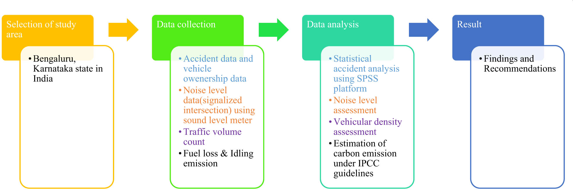
Methodology flowchart.
Accident data are compiled based on accident severity, killed and injured, and fatal and non-fatal accidents. Accident severity refers to the degree or extent of harm or damage resulting from an accident, encompassing its impact on individuals, property, or the environment. The Ministry of Road Transport and Highways (MoRTH) published road accident data from 2013 to 2022, which is used in the present study for the analysis. The Transport Research Wing, functioning under the authority of the MoRTH, is tasked with the systematic gathering of accident data from state police departments adhering to the standardized formats mandated by the United Nations Economic and Social Commission for Asia and the Pacific, as delineated within the Asia Pacific Road Accident Data base project. In addition, vehicle ownership data are collected from the Regional Transport Office official website. The study ensures the accuracy and reliability of the data for subsequent analysis at a macro level. These data serve as a crucial component for understanding vehicle distribution and trends within the city, thereby enhancing the robustness of the study’s findings. Noise data were systematically collected using a sound level meter, calibrated as per the manufacturer’s instructions, and positioned at specific points based on proximity to noise sources and environmental factors. Measurements were taken at three signalized intersections: Konanakunte metro station, JP Nagar metro station, and Deve Gowda Petrol Pump, with ambient noise levels recorded in decibels (dB). The equipment was calibrated for accuracy prior to use. A traffic volume study was conducted at the selected intersections over a span of 7 days to assess vehicular movement patterns. The data collected were further utilized for vehicular density assessment, where each vehicle category was represented by distinct colours for better comprehension. The noise monitoring adhered strictly to the Central Pollution Control Board (CPCB) 2005 standards and ISO 1996 parts 1 and 2 guidelines, using a tripod at 1.5 m above ground. Ideal conditions, including low humidity and wind speeds below 5 m/s, were ensured, and equipment was meticulously calibrated at each site. This adherence to standards ensures the accuracy and reliability of the data collected. Fuel loss data are collected by selecting specific intersections for study and gathering relevant information, such as traffic volume, vehicle types, road conditions, and other factors. A detailed plan for data collection is then developed, outlining the frequency and the duration of data gathering.
While the data collection methodology in this study follows a comprehensive and systematic approach, certain limitations must be acknowledged. The sampling technique, though intended to be representative, may be influenced by geographical constraints, temporal variations, and potential biases in data availability. In addition, factors such as traffic flow dynamics, environmental conditions, and human behaviour may introduce variability in the collected data. These limitations could impact the broader applicability of the findings, especially in different urban settings or infrastructure conditions. Future research can address these challenges by expanding data collection across multiple locations, incorporating additional variables, and utilizing advanced statistical methods to minimize biases.
3.1 Accident analysis
3.1.1 Accident severity
Accident severity refers to the degree or the extent of harm or damage caused by an accident. It also measures the seriousness and the impact of an accident on individuals, property, or the environment. The accident severity is calculated using Equation (1).
3.1.2 Fatal and non-fatal accidents
A fatal accident is defined by an incident or an event, resulting in the death of one or more individuals, and a non-fatal accident pertains to an occurrence that causes injuries, harm, or damage to individuals involved without resulting in death.
3.1.3 Accident rate and fatality rate based on population
The analysis of accident and fatality rates are based on population is a critical component in understanding the dynamics of road safety. These rates serve as key indicators to assess the incidence and severity of accidents relative to the population size. Such assessments contribute significantly to the formulation of targeted intrusions and policies aimed at mitigating risks and improving overall safety. Examining these proportions provides insights into the extent of the impact of accidents on a community, facilitating informed decision-making for the implementation of effective measures to enhance road safety and reduce fatalities. The accident rate and fatality rate on the basis of population are given as Equations (2) and (3), respectively.
where ARp is the accident rate per 100,000 population, TA is the total accident, P is the population, FRp is the fatality rate per 100,000 population, and FA is the fatal accident.
3.1.4 Accident rate and fatality rate based on vehicle registration
The accident rates and fatality rates based on vehicle ownership are integral to understand the road safety dynamics. These rates constitute crucial indicators for unravelling the complex interplay between accident occurrences, fatalities, and the prevalence of vehicles within a given population. This analysis plays a pivotal role as a cornerstone in formulating evidence-based policies, directing initiatives toward the discernible patterns associated with vehicle ownership. The accident and fatality rates are calculated based on Equations in (4) and (5), respectively.
where ARV is the accident rate per 100,000 vehicles registered, TA is the total accident, V is the vehicles registered, FRv is the fatality rate per 100,000 vehicles registered, and FA is the fatal accident.
3.1.5 Development of prediction model
Statistical package for the social sciences (SPSS) is a robust tool widely utilized for statistical analysis, data management, and documentation. In this study, regression analysis was performed to investigate the relationship between variables year versus total accident, persons killed versus total accident, persons injured versus total accident, fatal accident versus total accident, non-fatal versus total accident, and population versus vehicle registration, population versus total accident, and vehicle registration versus total accident. The regression model’s significance was confirmed, indicating a statistically significant relationship. SPSS facilitates curve estimation to identify the best-fit model for data, offering 11 types of curves, including linear, logarithmic, inverse, quadratic, cubic, compound, power, and S-curve models. Curve estimation helps in understanding complex data patterns and predicting outcomes more accurately. This comprehensive approach underscores the utility of SPSS in conducting detailed statistical analyses and deriving meaningful insights from data.
3.2 Noise pollution analysis
The primary focus resides in the estimation and evaluation of noise levels arising from urban road traffic, aiming to assess and quantify the volume of noise generated by vehicles and its consequential impact on the surrounding environment. The author further engages in the systematic measurement of sound levels at various signalized intersections, undertaking a meticulous analysis of the gathered data to discern patterns and variations in noise levels.
A traffic volume study was carried out in the designated location over a span of 7 days, yielding the subsequent results. Graphs presented in Figures 22–24 illustrate the traffic volume analysis.
3.3 Total fuel loss and analyses of carbon footprint
The primary objective of the author pertains to the quantification of fuel loss and carbon footprint assessments within signalized intersections, referable to vehicular idling periods. The author seeks to ascertain the aggregate fuel wastage and emissions of carbon dioxide resulting from traffic congestion at these junctions, thereby illuminating the environmental consequences of vehicular activity. Through meticulous analysis, the author attempts to provide a comprehensive understanding of the magnitude of carbon emissions generated by vehicles during idling periods, and to underscore the consequential impact on the environment. Moreover, the research aims to offer insights into potential mitigation strategies to alleviate such environmental burdens, fostering sustainable urban mobility practices. By outlining the complex dynamics of fuel consumption and emissions at signalized intersections, the study attempts to contribute to the broader discourse on environmental sustainability in urban transportation systems.
3.3.1 Monitoring procedure
Initially, traffic monitoring is conducted by collecting data on the typical volume of vehicles, their makes, and their idling durations during peak hours at the intersection. The fuel consumption rate during idling is determined for each vehicle type through meticulous calculation. This process involves both field measurements and reference to reliable sources to ensure accuracy. Subsequently, the total fuel consumption due to idling at intersections is determined using this information. Carbon dioxide (CO2) emissions from fuel consumption are then calculated using emission factors specific to various vehicle and fuel categories. These emission factors are derived from the recommendations provided by the IPCC, which encompass emission factors corresponding to various fuel types. Furthermore, it is noteworthy that a tripod stand with camera has been positioned above the ground level at 1.5 m to facilitate data collection.
3.3.2 Calculation of emission factor
The IPCC furnishes guidelines for the computation of emission factors, essential for estimating greenhouse gas emissions. According to the guidelines established by the IPCC, the oxidation factor employed is set at 99%, as 1% of the carbon remains un-oxidized. The carbon content in 1 gallon of petrol amounts to 2,421 g, while 1 gallon of diesel contains 2,778 g of carbon. In the context of compressed natural gas (CNG), it is relevant to acknowledge that 1 l of CNG contains precisely 614 g of carbon. In addition, it is imperative to note that the combustion process of CNG requires 1,638 g of oxygen for optimal efficiency. The carbon dioxide emissions per litre for petrol, diesel, and CNG vehicles, detailed in kilograms per gallon, are systematically presented in Table 1, highlighting the CO2 emissions associated with each fuel type.
Emission factor for fuels
| Type of fuel | CO2 emissions per litre of fuel | |
|---|---|---|
| Petrol |
|
Note
|
| Diesel |
|
|
| CNG |
|
|
3.3.3 Data analysis
The data concerning fuel loss attributed to traffic during idling periods at signalized intersections, along with corresponding CO2 emissions, has been meticulously documented and presented in both tabular formats. This comprehensive compilation offers valuable insights into the environmental and economic implications of idling vehicles at intersections, facilitating informed decision-making in transportation management and policy development. The total fuel loss at the intersections of Konanakunte metro station, JP Nagar metro station, and Deve Gowda petrol pump is detailed in Tables 2–4, respectively. These tabulated presentations meticulously detail the quantification of fuel loss incurred at each specific intersection, providing a granular understanding of the economic and environmental implications associated with idling vehicles at these locations.
Total fuel loss and CO2 emissions at Konanakunte metro station intersection
| Vehicle category | Fuel type | A = No of vehicle | B = Idling fuel consumption (ml/min) | C = Total idling time (min) | L = Total fuel loss L =
|
Total CO2 emission (kg) =
|
|---|---|---|---|---|---|---|
| Two-wheeler | Petrol | 1,695 | 2.36 | 26 | 104.01 | 276.65 |
| Three-wheeler | CNG | 1,015 | 0.8 | 26 | 21.11 | 53.20 |
| Diesel | 442 | 3.6 | 26 | 41.37 | 126.18 | |
| Car | Petrol | 857 | 10.2 | 26 | 227.28 | 604.56 |
| Diesel | 400 | 8.1 | 26 | 84.24 | 256.93 | |
| LCV | Diesel | 136 | 8.1 | 26 | 28.64 | 87.36 |
| HCV and Bus | Diesel | 137 | 15.6 | 26 | 55.57 | 169.48 |
Total fuel loss and CO2 emissions at JP Nagar metro station intersection
| Vehicle category | Fuel type | A = No of vehicle | B = Idling fuel consumption (ml/min) | C = Total idling time (min) |
L = total fuel loss L =
|
Total CO2 emission (kg) =
|
|---|---|---|---|---|---|---|
| Two-wheeler | Petrol | 1,910 | 2.36 | 31 | 139.74 | 371.70 |
| Three-wheeler | CNG | 1,267 | 0.8 | 31 | 31.42 | 79.18 |
| Diesel | 327 | 3.6 | 31 | 36.49 | 111.30 | |
| Car | Petrol | 858 | 10.2 | 31 | 271.30 | 721.66 |
| Diesel | 509 | 8.1 | 31 | 127.81 | 389.82 | |
| LCV | Diesel | 130 | 8.1 | 31 | 32.64 | 99.56 |
| HCV and Bus | Diesel | 160 | 15.6 | 31 | 77.38 | 236.00 |
Total fuel loss and CO2 emissions at Deve Gowda petrol pump intersection
| Vehicle category | Fuel type | A = No of vehicle | B = Idling fuel consumption (ml/min) | C = Total idling time (min) |
L = Total fuel loss L =
|
Total CO2 emission (kg) =
|
|---|---|---|---|---|---|---|
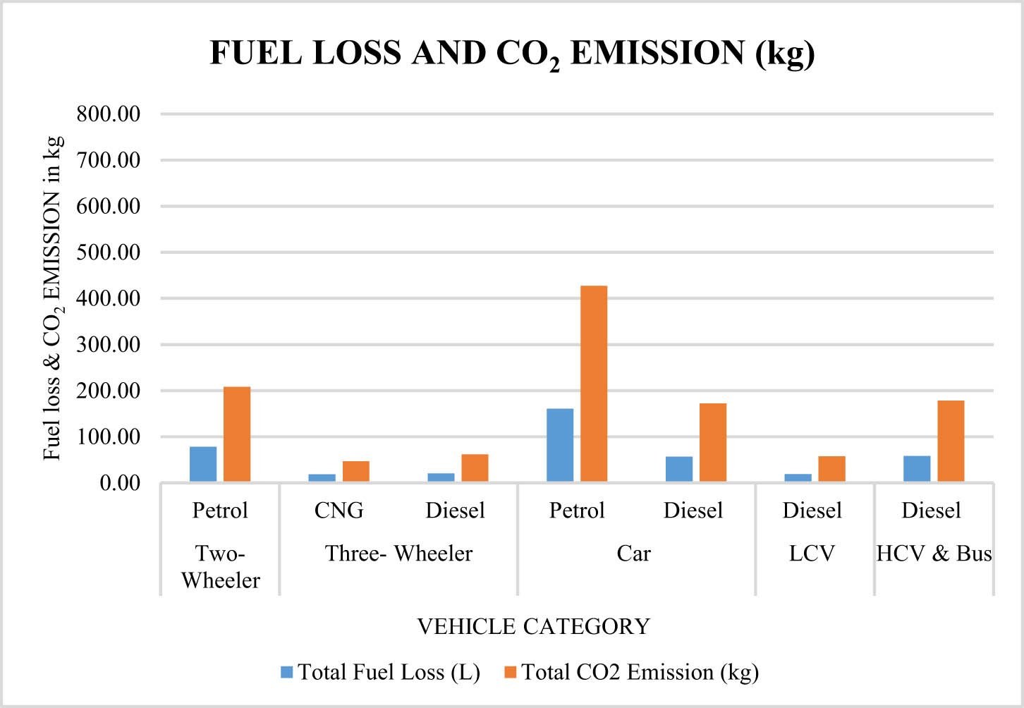
| Two-wheeler | Petrol | 1,442 | 2.36 | 23 | 78.27 | 208.20 |
| Three-wheeler | CNG | 1,017 | 0.8 | 23 | 18.71 | 47.16 |
| Diesel | 245 | 3.6 | 23 | 20.29 | 61.87 | |
| Car | Petrol | 685 | 10.2 | 23 | 160.70 | 427.46 |
| Diesel | 303 | 8.1 | 23 | 56.45 | 172.17 | |
| LCV | Diesel | 102 | 8.1 | 23 | 19.00 | 57.96 |
| HCV and Bus | Diesel | 163 | 15.6 | 23 | 58.48 | 178.38 |
4 Results
4.1 Accident analysis
4.1.1 Accident severity
The cumulative count of total accidents over the past decade 2013 to 2022 is depicted in Figure 2. The data reveal a marginal decrease in road accidents from 2013 to 2015, followed by a slight increase in 2016. Notably, there is a two-step decrease in 2017, followed by a corresponding two-step increase in 2018. In addition, there is a slight upward trend from 2018 to 2019, and a subsequent decrease in the years 2020 and 2021 attributed to the COVID-19 pandemic. Furthermore, a slight resurgence in accident rates occurred in 2022. Figure 3 presents a graphical depiction of the fatalities and injuries recorded from 2013 to 2022. It is noteworthy that the number of individuals injured in road accidents holds a higher percentage share of the overall total of road accidents during this period.

Total accident data of Bengaluru city 2013–2022.
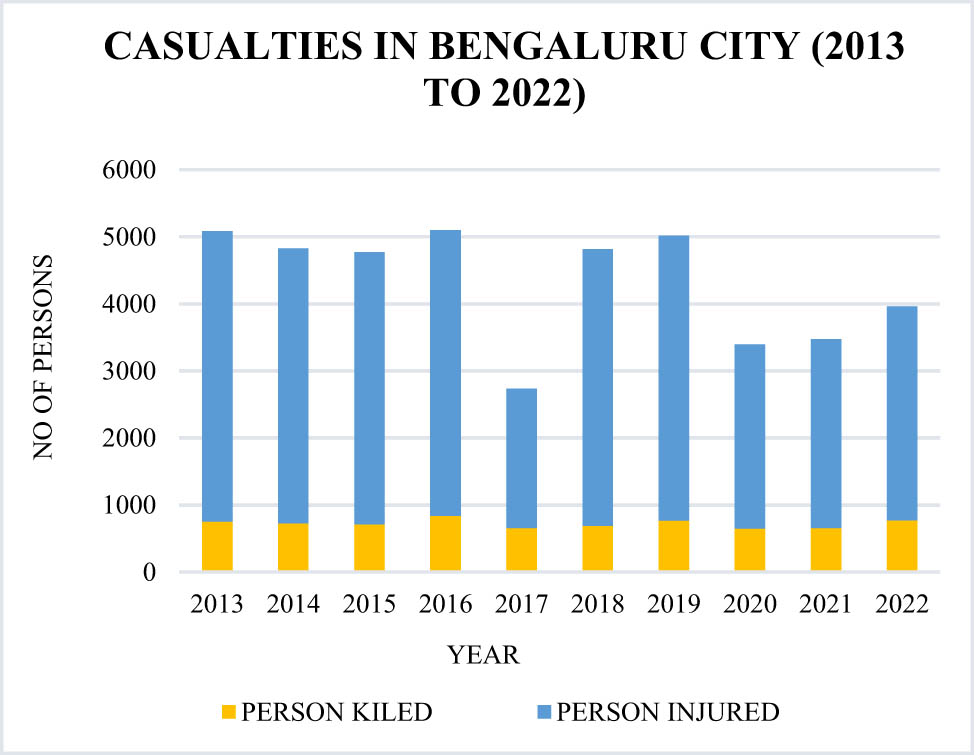
Casualties in Bengaluru city 2013–2022.
The line graph in Figure 4 illustrates the accident severity in Bengaluru city over a 10-year period from 2013 to 2022. The data indicate relatively stable accident severity levels from 2013 to 2016, followed by a pronounced peak in 2017, signifying a substantial increase in severity during that year. Subsequently, there is a marked decline, with severity levels stabilizing around 15 from 2018 to 2022.

Accident severity of Bengaluru city 2013–2022.
4.1.2 Fatal and non-fatal accidents
The number of individuals involved in both fatal and non-fatal accidents within Bengaluru city from 2013 to 2022 is illustrated in Figure 5. In 2016, the recorded incidence of fatal accidents was the highest, while the lowest was observed in the year 2017. Similarly, concerning non-fatal accidents, the highest occurrence was documented in 2016, whereas the lowest was recorded in 2017. There is a decrease from 2018 to 2019.

Fatal and non-fatal accidents of Bengaluru city 2013–2022.
4.1.3 Population and vehicle registration trend
The population trends in Bengaluru city from 2013 to 2022 are illustrated in Figure 6. According to the graph, the population exhibits a consistent upward trajectory over the specified period. Simultaneously, the total number of registered vehicles in Bengaluru city over the past decade (2013–2022) is visualised in Figure 7. Notably, there has been a substantial 42% increase from 2013 to 2022. This marked surge can be attributed to the rapid pace of urbanization and the city’s emergence as a prominent IT hub.

Population trend in Bengaluru city (2013–2022).

Total vehicle registered in Bengaluru city (2013–2022).
4.1.4 Accident and fatality rate based on population and vehicle registration
The visual representation of accident and fatality rates relative to the population reveals significant trends is shown in Figure 8. The accident rate shows a significant decrease as the population increases, declining from 55.73 to 28.97 over the past decade (2013 to 2022), representing nearly a 50% reduction. Similarly, the fatality rate exhibits a marginal decrease from 7.83 to 5.85 during the same period, highlighting sustained efforts toward improved road safety.

Accident and fatality rate based on population (2013–2022).
The accident rate and the fatality rate based on vehicle ownership in Bengaluru are illustrated in Figure 9. In 2013, the highest recorded accident rate was 113.94, marking the onset of a gradual decline. The accident rate has decreased by approximately 35% by 2022, with a slight increase observed in 2019. Similarly, the fatality rate has shown a steady reduction from 16% in 2013 to 7% in 2022, whereas there is a marginal increase in the year 2019. These trends offer valuable insights into the dynamics of road safety concerning vehicle ownership in the city.

Accident rate and fatality rate based on vehicle registered (2013–2022).
4.1.5 Relationship established through statistical analysis
The selection of the best-fit curve is based on a comprehensive regression analysis, involving a comparison of R 2 values, F-test statistics, standard errors of the estimate, and significance levels for each model. The model considers the best fit, which has the highest R 2 and F-test values, the lowest standard error of the estimate, and must meet a 95% confidence level for significance. This approach ensures that the chosen model provides the most accurate and reliable representation of the data.
The comprehensive nature from Figures 10–17 contributes to a thorough understanding of the intricate relationships among the variables year versus total accident, persons killed versus total accident, persons injured versus total accident, fatal accident versus total accident, non-fatal versus total accident, population versus vehicle registration, population versus total accident, and vehicle registration versus total accidents.

Prediction model for year versus total accidents.

Prediction model for persons killed versus total accidents.

Prediction model for persons injured versus total accidents.

Prediction model for fatal accident versus total accidents.
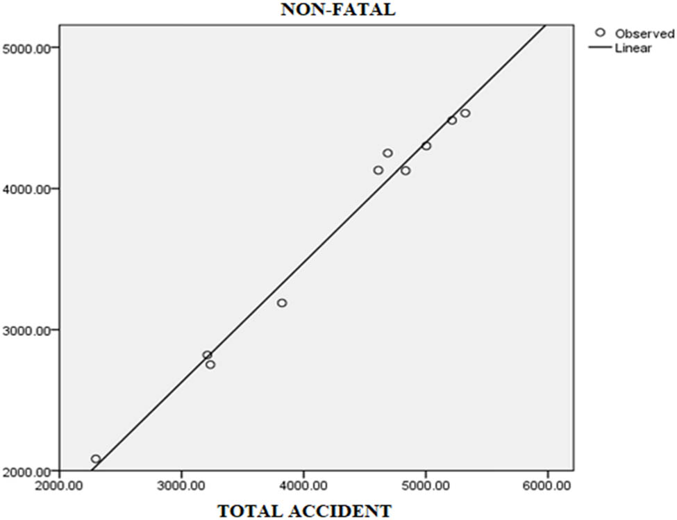
Prediction model for non-fatal accident versus total accidents.

Prediction model for population versus vehicle registration.

Prediction model for population versus total accidents.

Prediction model for vehicle registration versus total accidents.
Based on the SPSS analysis, the linear regression model explores the relationship between the number of total accidents and the number of persons injured. The model demonstrates a strong fit with an R value of 0.983 and an R 2 of 0.966, indicating that 96.6% of the variance in injuries can be explained by the total number of accidents. The adjusted R 2 is 0.962, accounting for the model’s degrees of freedom. The ANOVA table confirms the model’s significance with an F-value of 227.363 and a p-value of 0.000, indicating the relationship between total accidents and injuries, and the details are presented in Tables 5–7. Overall, the analysis supports the conclusion that the number of total accidents is a strong predictor of the number of persons injured.
Model summary for persons injured versus total accident
| Model summary | |||
|---|---|---|---|
| R | R 2 | Adjusted R 2 | Std. error of the estimate |
| 0.983 | 0.966 | 0.962 | 158.839 |
ANOVA for persons injured versus total accident
| ANOVA | |||||
|---|---|---|---|---|---|
| Sum of squares | df | Mean square | F | P | |
| Regression | 5736355.381 | 1 | 5736355.381 | 227.363 | 0.000 |
| Residual | 201839.119 | 8 | 25229.890 | ||
| Total | 5938194.500 | 9 | |||
Coefficient for persons injured versus total accident
| Coefficients | |||||
|---|---|---|---|---|---|
| Unstandardized coefficients | Standardized coefficients | t | Sig. | ||
| B | Std. error | Beta | |||
| Total accident (constant) | 0.781 | 0.052 | 15.079 | 15.079 | 0.000 |
| 299.921 | 224.387 | 1.337 | 1.337 | 0.218 | |
The statistical analysis in Table 8 identifies the best-fit curve for each relationship, with the “Equation” column representing the prediction formula for each case. The analysis shows a quadratic trend for “Year versus Total Accident” and a logarithmic trend for “Population versus Vehicle Registration,” while most other relationships follow a linear pattern. These models were selected based on regression analysis criteria, including R 2 values, F-tests, and confidence levels, ensuring accurate representation of data trends. These equations are used to understand trends, make predictions, and analyze the impact of one variable on another in accident studies.
Relationship between variable tested using statistical analysis
| Fig no. | Relationship between variables | Type of the curve | Equations |
|---|---|---|---|
| 9 | Year versus total accident | Quadratic |
|
| 10 | Persons killed versus total accident | Linear |
|
| 11 | Persons injured versus total accident | Linear |
|
| 12 | Fatal accident versus total accident | Linear |
|
| 13 | Non-fatal versus total accident | Linear |
|
| 14 | Population versus vehicle registration | Logarithmic |
|
| 15 | Population versus total accident | Linear |
|
| 16 | Vehicle registration versus total accident | Linear |
|
The regression models provide valuable insights into the relationships between population growth, vehicle registrations, and road safety, but their robustness in capturing complex interactions needs assessment. The current bivariate models (e.g., population vs vehicle registration, vehicle registration vs accidents) may oversimplify real-world nonlinear relationships influenced by factors like infrastructure and regulations. A multivariate approach with interaction terms could better reflect these dependencies. Verifying assumptions such as linearity and homoscedasticity would enhance model reliability. Future studies can explore time-series or machine learning models for improved accuracy in predicting road safety trends.
4.2 Noise pollution
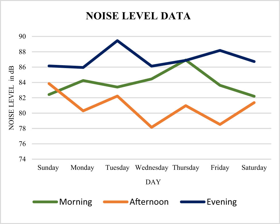
The noise levels observed during the morning, afternoon, and evening periods at Konanakunte metro station, JP Nagar Metro Station, and Deve Gowda Petrol Pump Intersection are illustrated in Figures 18–20, respectively. Notably, all three locations have higher noise levels in the evening, exceeding 88 dB. Conversely, Figure 21 presents a comparative analysis of these three junctions, revealing that JP Nagar Metro Station experiences a higher noise level in contrast to the other two intersections.

Noise level data at Konanakunte metro station intersection.
Noise level data at JP Nagar metro station intersection.

Noise level data at Deve Gowda petrol pump intersection.

Comparison of noise level data for three intersections.
4.2.1 Traffic volume
The traffic volume counts of Konanakunte metro station intersection, JP Nagar metro station intersection, and Deve Gowda petrol pump intersection are illustrated in Figures 22–24, respectively, and is categorized by the vehicle type. Each vehicle category is represented by a distinct colour to enhance comprehension. In all the three intersections, three-wheeler dominates overs other vehicle category exceeding 60,000 Passenger Car Unit (PCU). In addition, Figure 25 presents a comparative analysis of the volume counts across all three selected intersections, which reveals that JP Nagar metro station intersection has the highest vehicular volume among the other two.

Volume count at Konanakunte metro station intersection.

Volume count at JP Nagar metro station intersection.

Volume count at Deve Gowda petrol pump intersection.

Comparison of volume count for three intersections.
4.3 Total fuel loss and carbon footprint
Graphical representations of the total fuel loss and CO2 emissions at the intersections of Konanakunte metro station, JP Nagar metro station, and Deve Gowda petrol pump are depicted in Figures 26–28, respectively. These figures categorize the data by vehicle and fuel types. These visual presentations offer a comprehensive overview of the quantitative data, facilitating a nuanced understanding of the distribution of fuel loss and emissions across different vehicle and fuel categories at each specific intersection. Such graphical representations are instrumental in identifying patterns and trends. JP Nagar metro station intersection shows the highest fuel loss and carbon emission. However, the Deve Gowda petrol pump intersection shows the least fuel loss and carbon emission.

Fuel loss and CO2 emissions at Konanakunte metro station intersection.

Fuel loss and CO2 emissions at JP Nagar metro station intersection.
Fuel loss and CO2 emissions at Deve Gowda petrol pump intersection.
The comparative analysis of the total fuel loss across different fuel categories for all three intersections is illustrated in Figure 29, while Figure 30 illustrates the comparison of fuel loss among the three intersections. These graphical representations offer insights into the variations in fuel loss patterns across different fuel types and intersections, aiding in the identification of potential areas for targeted interventions to mitigate fuel wastage and enhance overall transportation efficiency.

Comparison of total CO2 emission by fuel category at three intersections.

Comparison of total CO2 emission at three intersections.
5 Results and discussion
Traffic accidents are analyzed at a macro level, revealing complex relationships between population growth, vehicle registrations, and traffic safety.
The past decade has seen a significant population growth of 41% in the city, which has been accompanied by a concerning increase in road fatalities by 5.3%. These data indicate a rise in accident severity by 40%, highlighting the growing risks and challenges associated with urban transportation. The correlation between population growth and increased accident severity underscores the need for improved road safety measures and infrastructure.
Vehicle registrations have increased by 2.4 times from 2013 to 2022, corresponding with a 40% rise in population. This trend underscores the growing demand for transportation and highlights the need for enhanced infrastructure and traffic management strategies.
The accident rate and the fatality rate have demonstrated a decreasing trend relative to the population increase. The accident rate has notably decreased from 55.73 to 28.97 over the past 10 years, reflecting a nearly 50% reduction, while the fatality rate has seen a marginal decline from 7.83 to 5.85, highlighting ongoing improvements in road safety.
The accident and fatality rates have shown a decreasing trend despite the rise in vehicle registrations. The accident rate decreased from a peak of 113.94 in 2013 to approximately 35.06 in 2022, while the fatality rate fell from 16.05 to 7.08 during the same period, indicating improvements in road safety measures and traffic management practices.
The accident prediction model was validated using R 2 and F-tests, demonstrating a strong linear relationship across various variable pairings. The relationships between the year and total accidents follow a quadratic curve, while other variables, such as persons killed, injured, and types of accidents, exhibit linear correlations. In addition, the model shows a logarithmic relationship between population and vehicle registration, and a linear relationship between population and total accidents, as well as between vehicle registration and total accidents. These findings underscore the model’s robustness in capturing key trends in urban traffic safety and vehicle dynamics.
The trend of total accidents over the years follows a quadratic pattern due to fluctuations in mobility and external disruptions. Initially, accidents increased with rising vehicle registrations and urban expansion. However, the COVID-19 pandemic caused a sharp decline in traffic movement due to lockdowns, leading to a temporary reduction in accidents. Post-pandemic, as restrictions were lifted and traffic volumes rebounded, accidents surged again. This nonlinear variation justifies the quadratic nature of the relationship, capturing both the decline during the pandemic and the subsequent rise.
The logarithmic relationship between vehicle registration and population indicates that as the population increases, the growth rate of vehicle registrations slows down. This is due to urban saturation, infrastructure limits, rising costs, and policy interventions that promote alternative transport modes. Unlike a linear trend, this pattern reflects the diminishing growth in vehicle ownership as cities develop and mobility preferences evolve.
The assessment of traffic noise at selected locations in Bengaluru revealed concerning findings.
The J.P. Nagar intersection exhibits the highest noise levels, exceeding 85 dB, surpassing the Central Pollution Control Board’s prescribed limit of 70–75 dB. This elevated noise level is attributed to the higher traffic volume at J.P. Nagar compared to the other two intersections.
Noise levels peak at up to 85 dB during weekday mornings and evenings, as well as weekend evenings, attributable to the increased traffic volume during these peak times.
The dominance of three-wheelers in the traffic composition at all three intersections, exceeding 50,000 PCUs, significantly influences urban transportation dynamics. Their high manoeuvrability and frequent stops contribute to traffic congestion, affecting overall flow efficiency. In addition, their interaction with two-wheelers (over 22,000 PCUs) and four-wheelers (exceeding 20,000 PCUs) raises safety concerns due to differences in speed, stability, and space requirements. From an environmental perspective, if a substantial portion of these three-wheelers are non-electric, they may contribute disproportionately to noise pollution and carbon emissions. Addressing these challenges requires targeted infrastructure improvements such as dedicated lanes, optimized signal timing, and policy interventions promoting sustainable alternatives like electric three-wheelers.
The assessment of total fuel loss and carbon emissions from vehicles due to idling at the selected signalized intersections revealed several key findings.
The predominance of petrol vehicles over CNG and diesel cars leads to increased petrol fuel loss, resulting in 276.65 kg, 1,093 kg, and 635.67 kg of CO2 emissions at Konanakunte metro station, J.P. Nagar Metro, and Deve Gowda Petrol Pump Intersection, respectively, during vehicle idling at traffic signals.
The J.P. Nagar intersection experiences a greater overall fuel loss, resulting in 2009.22 kg of CO2 emissions, compared to the Konanakunte metro station intersection and Deve Gowda intersections. This is attributed to the higher volume of vehicles and increased delays at this location.
The study reveals a complex interplay between population growth, vehicle registrations, and urban transportation challenges in Bengaluru. The significant increase in population and vehicle registrations has coincided with a rise in road fatalities and noise pollution, particularly at high-traffic intersections such as J.P. Nagar. Despite improvements in road safety, as evidenced by the decreasing accident and fatality rates, the growing traffic volume contributes to elevated CO2 emissions from vehicle idling, highlighting the need for enhanced infrastructure and traffic management strategies to mitigate these impacts.
The analysis highlights potential urban design and traffic management interventions to mitigate noise pollution and carbon emissions at signalized intersections. Implementing adaptive signal control systems can optimize traffic flow, reducing idling time and associated emissions. Establishing low-emission zones may further minimize vehicular pollution in critical areas. In addition, promoting non-motorized transport infrastructure and incorporating traffic calming measures such as roundabouts and speed regulation can effectively reduce noise levels and enhance overall environmental quality.
6 Conclusion
This study highlights the complex relationship between population growth, vehicle registrations, and urban transportation challenges in Bengaluru. Over the past decade, the city’s population grew by 41%, while vehicle registrations increased 2.4 times. Despite this, road safety has improved, with the accident rate declining from 55.73 to 28.97 per 100,000 people, and the fatality rate decreasing from 7.83 to 5.85 per 100,000 people. However, accident severity increased by 40%, emphasizing the need for enhanced safety measures. In addition, high traffic volumes at key intersections, such as J.P. Nagar, contributed to noise levels exceeding 85 dB, surpassing the CPCB limit of 70–75 dB. Prolonged vehicle idling at signalized intersections resulted in significant fuel wastage, leading to 2009.22 kg of CO₂ emissions at J.P. Nagar, the highest among the studied locations. These findings underscore the urgent need for integrated traffic management strategies, infrastructure improvements, and sustainable urban mobility solutions.
7 Mitigation strategies
The analysis highlights potential urban design and traffic management interventions to mitigate noise pollution and carbon emissions at signalized intersections. Implementing adaptive signal control systems can optimize traffic flow, reducing idling time and associated emissions. Establishing low-emission zones may further minimize vehicular pollution in critical areas. In addition, promoting non-motorized transport infrastructure and incorporating traffic calming measures such as roundabouts and speed regulation can effectively reduce noise levels and enhance overall environmental quality.
The findings highlight the need for integrated urban transportation strategies in rapidly growing Indian cities. Sustainable mass transit expansion, including metro and bus rapid transit (BRT) systems, can reduce dependency on private vehicles. Data-driven traffic management using AI and IoT can enhance road safety and reduce congestion. Mixed land-use planning can minimize travel distances, while developing active transport infrastructure promotes walking and cycling. In addition, policy-driven vehicle restrictions in high-density zones and investment in smart mobility solutions can improve urban transport efficiency and safety over time.
Further to reduce fuel loss and carbon emissions from idling, AI-based traffic management systems like Bengaluru’s BATCS can optimize signal timings and reduce congestion. Idle-stop technology in vehicles, which automatically shuts off the engine when stationary, should be encouraged through incentives. Expanding electric vehicle (EV) infrastructure with priority lanes and charging stations can promote cleaner transportation. Strict anti-idling policies in high-emission zones can further reduce environmental impacts. In addition, eco-driving awareness programs can educate drivers on fuel-efficient driving behaviours, contributing to lower emissions and fuel savings.
-
Funding information: The authors state no funding involved.
-
Author contributions: REK and MRS: conceptualization, methodology, formal analysis, investigation, writing – original draft, validation, visualization, project administration, data curation, and writing – review and editing. CN, AT, and SRN: supervision, methodology, resources, validation, project administration, and writing – review and editing. REK and AT: validation, visualization, investigation, data curation, and writing – review and editing.
-
Conflict of interest: The authors state no conflict of interest.
-
Data availability statement: All required data already presented in the manuscript.
References
[1] Othman AG, Ali KH. Transportation and quality of life. Plan Malays. 2020;18(3):35–50. 10.21837/PM.V18I13.774.Search in Google Scholar
[2] Verma A, Harsha V, Subramanian GH. Evolution of urban transportation policies in India: a review and analysis. Transp Dev Econ. 2021;7(2):1–15. 10.1007/s40890-021-00136-1.Search in Google Scholar
[3] Ravish R, Swamy SR. Intelligent traffic management: a review of challenges, solutions, and future perspectives. Transp Telecommun. 2021;22(2):163–82. 10.2478/ttj-2021-0013.Search in Google Scholar
[4] Gaudon JM, McTavish MJ, Hamberg J, Cray HA, Murphy SD. Noise attenuation varies by interactions of land cover and season in an urban/peri-urban landscape. Urban Ecosyst. 2022;25(3):811–8. 10.1007/s11252-021-01194-4.Search in Google Scholar PubMed PubMed Central
[5] Forouhid AE, Ilkah M, Mahmoudi J. Noise pollution contours in metro stations (case study of Tehran metro). J Meas Eng. 2021;9(4):193–206. 10.21595/jme.2021.22114.Search in Google Scholar
[6] Abdel Wahed Ahmed MM, Abd El Monem N. Sustainable and green transportation for better quality of life case study greater Cairo–Egypt. HBRC J. 2020;16(1):17–37. 10.1080/16874048.2020.1719340.Search in Google Scholar
[7] Borza E-V, Băldean D-L, Borzan A-I. Research Concerning Fuel Economy Coefficient and Carbon Foot Print in Various Conditions for a City Compact Size Vehicle with Digital Control for a Green Solution and Method at Technical University from Cluj-Napoca. Cham, Switzerland: Springer International Publishing; 2019. 10.1007/978-3-319-94409-8_22.Search in Google Scholar
[8] Alobaidi MK, Badri RM, Salman MM. Evaluating the negative impact of traffic congestion on air pollution at signalized intersection. IOP Conf Ser Mater Sci Eng. 2020;737(1). 10.1088/1757-899X/737/1/012146.Search in Google Scholar
[9] Abdulhafedh A. Road crash prediction models: different statistical modeling approaches. J Transp Technol. 2017;7(2):190–205. 10.4236/jtts.2017.72014.Search in Google Scholar
[10] La Torre F, Meocci M, Domenichini L, Branzi V, Tanzi N, Paliotto A. Development of an accident prediction model for Italian freeways. Accid Anal Prev. 2019;124:1–11. 10.1016/j.aap.2018.12.023.Search in Google Scholar PubMed
[11] Maraj E, Kuka S. Prediction of road accidents using fuzzy logic. J Multidiscip Eng Sci Technol. 2019;6(12):2458–9403, www.jmest.org.Search in Google Scholar
[12] Sisbreno AP, Sumilhig JA, Venci TJC, Canseco-Tunacao HAR, Cavero DBM. Black spot identification and road accident prediction model on Cebu South Coastal Road (CSCR). IOP Conf Series: Earth Environ Sci. 2023;1184(1):012022. 10.1088/1755-1315/1184/1/012022.Search in Google Scholar
[13] Bhavsar R, Amin A, Zala L. Development of model for road crashes and identification of accident spots. Int J Intell Transp Syst Res. 2021;19(1):99–111. 10.1007/s13177-020-00228-z.Search in Google Scholar
[14] Gebretensay FB, Juremalani J. Road traffic accident analysis and prediction model : a case study of vadodara City. Int Res J Eng Technol. 2018;5(1):191–6.Search in Google Scholar
[15] Jin Z, Noh B. From prediction to prevention: leveraging deep learning in traffic accident prediction systems. Electronics. 2023;12(20):4335.10.3390/electronics12204335Search in Google Scholar
[16] Galatioto F, Catalano M, Shaikh N, McCormick E, Johnston R. Advanced accident prediction models and impacts assessment. IET Intell Transp Syst. 2018;12(9):1131–41. 10.1049/iet-its.2018.5218.Search in Google Scholar
[17] Elvik R. The development of a road safety policy index and its application in evaluating the effects of road safety policy. Accid Anal Prev. 2024 Jan;202:107612. 10.1016/j.aap.2024.107612.Search in Google Scholar PubMed
[18] Mohanty M, Samal SR. Role of young drivers in road crashes: A case study in India. Eur Transp - Trasp Eur. 2019;74(1):e1.Search in Google Scholar
[19] Badveeti A, Mir MS, Badweeti K. The evaluation of traffic congestion analysis for the srinagar city under mixed traffic conditions. In Lecture notes in civil engineering. Vol. 69. Singapore: Springer Singapore Pte. Ltd.; 2020 Aug. p. 85–98. 10.1007/978-981-15-3742-4_6.Search in Google Scholar
[20] Tufajjal Hossain M. Assessment of traffic congestion by traffic flow analysis in Pabna Town. Am J Traffic Transp Eng. 2019;4(3):75. 10.11648/j.ajtte.20190403.11.Search in Google Scholar
[21] Zheng Z, Wang Z, Zhu L, Jiang H. Determinants of the congestion caused by a traffic accident in urban road networks. Accid Anal Prev. 2020;136:105327. 10.1016/j.aap.2019.105327.Search in Google Scholar PubMed
[22] Naresh P, Tallam T, Naveen Kumar C. Analysis of Bottleneck at the Midblock in Hyderabad City. In Lecture notes in civil engineering. Singapore: Springer Singapore Pte. Ltd. (Springer Nature); 2022. 10.1007/978-981-16-7509-6_28.Search in Google Scholar
[23] Abdulamer SH, Eedan HA. Effect of three-wheeled vehicles on the capacity of a traffic stream. J Eng Sustain Dev. 2021;25:3–165. 10.31272/jeasd.conf.2.3.16.Search in Google Scholar
[24] Vijayalakshm S, Raj K. Economic estimation of health and productivity impacts of traffic congestion : a case of Bengaluru City. Vol. 26. Bangalore: Institute for Social and Economic Change (ISEC); 2020.Search in Google Scholar
[25] Korr RK, Molugaram K, Bonala A, Thabassum S. Impact analysis of speed humps on Indian roads. J East Asia Soc Transp Stud. 2019;13:2073–90.Search in Google Scholar
[26] Mashros N, Md Nor MF, Kurnia AY, Hassan SA, Hassan NA, Yunus NZM. Evaluating the effectiveness of road humps in reducing vehicle speed: Case study of a university campus. Int J Adv Sci Eng Inf Technol. 2020;10(2):814–20. 10.18517/ijaseit.10.2.5836.Search in Google Scholar
[27] Ding H, Zhao X, Rong J, Ma J. Experimental research on the effectiveness of speed reduction markings based on driving simulation: A case study. Accid Anal Prev. 2013;60:211–8. 10.1016/j.aap.2013.08.007.Search in Google Scholar PubMed
[28] Rikhotso J, Ndambuki J, Kupolati W, Adeboje A, Kambole C. Ameliorating traffic congestion and impact on climate change with park and ride transport. Nigeria: Covenant University; 2017.Search in Google Scholar
[29] Islam Jony Prothan J. Transportation system analysis at the major road intersection in the CBD area of rangpur City, Bangladesh. Int J Transp Eng Technol. 2017;3(4):74–82. 10.11648/j.ijtet.20170304.15.Search in Google Scholar
[30] Li Q, Qiao F, Yu L. Risk assessment of in-vehicle noise pollution from highways. Environ Pollut Clim Chang. 2017;1(1):1000107. 10.4172/2573-458x.1000107.Search in Google Scholar
[31] Mi Z, Guan D, Liu Z, Liu J, Viguié V, Fromer N, et al. Cities: The core of climate change mitigation. J Clean Prod. 2019;207:582–9. 10.1016/j.jclepro.2018.10.034.Search in Google Scholar
[32] Ariyaratne RGRNK, Karunaratne DGGP, Elangasinghe MA, Manipura A, Kodithuwakku SP, Siribaddana AD, et al. Monitoring Carbon Monoxide (CO) levels at five major schools in Kandy city using real time air quality monitoring sensor network. https://www.researchgate.net/profile/Suranga-Kodithuwakku/publication/348848197.Search in Google Scholar
[33] Andrych-Zalewska M. Analysis of exhaust emission processes during the real driving emissions test. Arch Transp. 2023;66(2):123–48. 10.5604/01.3001.0053.6085.Search in Google Scholar
[34] Mądziel M, Campisi T. Assessment of vehicle emissions at roundabouts: a comparative study of pems data and microscale emission model. Arch Transp. 2022;63(3):35–51. 10.5604/01.3001.0015.9926.Search in Google Scholar
© 2025 the author(s), published by De Gruyter
This work is licensed under the Creative Commons Attribution 4.0 International License.
Articles in the same Issue
- Research Articles
- Modification of polymers to synthesize thermo-salt-resistant stabilizers of drilling fluids
- Study of the electronic stopping power of proton in different materials according to the Bohr and Bethe theories
- AI-driven UAV system for autonomous vehicle tracking and license plate recognition
- Enhancement of the output power of a small horizontal axis wind turbine based on the optimization approach
- Design of a vertically stacked double Luneburg lens-based beam-scanning antenna at 60 GHz
- Synergistic effect of nano-silica, steel slag, and waste glass on the microstructure, electrical resistivity, and strength of ultra-high-performance concrete
- Expert evaluation of attachments (caps) for orthopaedic equipment dedicated to pedestrian road users
- Performance and rheological characteristics of hot mix asphalt modified with melamine nanopowder polymer
- Second-order design of GNSS networks with different constraints using particle swarm optimization and genetic algorithms
- Impact of including a slab effect into a 2D RC frame on the seismic fragility assessment: A comparative study
- Analytical and numerical analysis of heat transfer from radial extended surface
- Comprehensive investigation of corrosion resistance of magnesium–titanium, aluminum, and aluminum–vanadium alloys in dilute electrolytes under zero-applied potential conditions
- Performance analysis of a novel design of an engine piston for a single cylinder
- Modeling performance of different sustainable self-compacting concrete pavement types utilizing various sample geometries
- The behavior of minors and road safety – case study of Poland
- The role of universities in efforts to increase the added value of recycled bucket tooth products through product design methods
- Adopting activated carbons on the PET depolymerization for purifying r-TPA
- Urban transportation challenges: Analysis and the mitigation strategies for road accidents, noise pollution and environmental impacts
- Enhancing the wear resistance and coefficient of friction of composite marine journal bearings utilizing nano-WC particles
- Sustainable bio-nanocomposite from lignocellulose nanofibers and HDPE for knee biomechanics: A tribological and mechanical properties study
- Effects of staggered transverse zigzag baffles and Al2O3–Cu hybrid nanofluid flow in a channel on thermofluid flow characteristics
- Mathematical modelling of Darcy–Forchheimer MHD Williamson nanofluid flow above a stretching/shrinking surface with slip conditions
- Energy efficiency and length modification of stilling basins with variable Baffle and chute block designs: A case study of the Fewa hydroelectric project
- Renewable-integrated power conversion architecture for urban heavy rail systems using bidirectional VSC and MPPT-controlled PV arrays as an auxiliary power source
- Exploitation of landfill gas vs refuse-derived fuel with landfill gas for electrical power generation in Basrah City/South of Iraq
- Two-phase numerical simulations of motile microorganisms in a 3D non-Newtonian nanofluid flow induced by chemical processes
- Sustainable cocoon waste epoxy composite solutions: Novel approach based on the deformation model using finite element analysis to determine Poisson’s ratio
- Impact and abrasion behavior of roller compacted concrete reinforced with different types of fibers
- Architectural design and its impact on daylighting in Gayo highland traditional mosques
- Structural and functional enhancement of Ni–Ti–Cu shape memory alloys via combined powder metallurgy techniques
- Design of an operational matrix method based on Haar wavelets and evolutionary algorithm for time-fractional advection–diffusion equations
- Design and optimization of a modified straight-tapered Vivaldi antenna using ANN for GPR system
- Analysis of operations of the antiresonance vibration mill of a circular trajectory of chamber vibrations
- Functions of changes in the mechanical properties of reinforcing steel under corrosive conditions
- Enhanced PAPR reduction in NOMA systems using modified SLM and PTS techniques for power-efficient 5G and beyond networks
- Hybrid mechanics-informed machine learning models for predicting mechanical failure in graphene sponge: a low-data strategy for mechanical engineering applications
- Design of shafts of a two-piece chain conveyor as a part of a modification of a mobile working machine
- Review Articles
- A modified adhesion evaluation method between asphalt and aggregate based on a pull off test and image processing
- Architectural practice process and artificial intelligence – an evolving practice
- 10.1515/eng-2025-0148
- Special Issue: 51st KKBN - Part II
- The influence of storing mineral wool on its thermal conductivity in an open space
- Use of nondestructive test methods to determine the thickness and compressive strength of unilaterally accessible concrete components of building
- Use of modeling, BIM technology, and virtual reality in nondestructive testing and inventory, using the example of the Trzonolinowiec
- Tunable terahertz metasurface based on a modified Jerusalem cross for thin dielectric film evaluation
- Integration of SEM and acoustic emission methods in non-destructive evaluation of fiber–cement boards exposed to high temperatures
- Non-destructive method of characterizing nitrided layers in the 42CrMo4 steel using the amplitude-frequency technique of eddy currents
- Evaluation of braze welded joints using the ultrasonic method
- Analysis of the potential use of the passive magnetic method for detecting defects in welded joints made of X2CrNiMo17-12-2 steel
- Analysis of the possibility of applying a residual magnetic field for lack of fusion detection in welded joints of S235JR steel
- Eddy current methodology in the non-direct measurement of martensite during plastic deformation of SS316L
- Methodology for diagnosing hydraulic oil in production machines with the additional use of microfiltration
- Special Issue: IETAS 2024 - Part II
- Enhancing communication with elderly and stroke patients based on sign-gesture translation via audio-visual avatars
- Optimizing wireless charging for electric vehicles via a novel coil design and artificial intelligence techniques
- Evaluation of moisture damage for warm mix asphalt (WMA) containing reclaimed asphalt pavement (RAP)
- Comparative CFD case study on forced convection: Analysis of constant vs variable air properties in channel flow
- Evaluating sustainable indicators for urban street network: Al-Najaf network as a case study
- Node failure in self-organized sensor networks
- Comprehensive assessment of side friction impacts on urban traffic flow: A case study of Hilla City, Iraq
- Design a system to transfer alternating electric current using six channels of laser as an embedding and transmitting source
- Security and surveillance application in 3D modeling of a smart city: Kirkuk city as a case study
- Modified biochar derived from sewage sludge for purification of lead-contaminated water
- The future of space colonisation: Architectural considerations
- Design of a Tri-band Reconfigurable Antenna Using Metamaterials for IoT Applications
- Special Issue: AESMT-7 - Part II
- Experimental study on behavior of hybrid columns by using SIFCON under eccentric load
- Special Issue: ICESTA-2024 and ICCEEAS-2024
- A selective recovery of zinc and manganese from the spent primary battery black mass as zinc hydroxide and manganese carbonate
- Special Issue: REMO 2025 and BUDIN 2025
- Predictive modeling coupled with wireless sensor networks for sustainable marine ecosystem management using real-time remote monitoring of water quality
- Management strategies for refurbishment projects: A case study of an industrial heritage building
- Structural evaluation of historical masonry walls utilizing non-destructive techniques – Comprehensive analysis