Use of modeling, BIM technology, and virtual reality in nondestructive testing and inventory, using the example of the Trzonolinowiec
-
Mateusz Napiórkowski
 ,
Mariusz Szóstak
,
Mariusz Szóstak

Abstract
This article presents the use of the building information modeling (BIM) methodology during the inventory of a residential building called “Trzonolinowiec” located in Wroclaw, Poland. The use of BIM methodology makes it possible to obtain more accurate two-dimensional (2D) documentation based on the three-dimensional (3D) model of the surveyed object. The article additionally discusses the possibility of extending the conducted inventory with new technologies (including laser scanners, unmanned aerial vehicles, and virtual reality [VR]). Laser scanners make it possible to take fast and accurate measurements in the form of point clouds, based on which it is possible to make accurate 3D models and then 2D projections. Unmanned aerial vehicles make it possible to inspect in hard-to-reach places and to make a point cloud (once the scanner is connected) of the facade and roof. VR was presented as a technology that allows immersive viewing of a virtual environment – a 3D model. The article discusses the scope prepared for the expertise and possible future directions during subsequent inventories. A 3D model of the inventoried building was prepared, mapping the building’s geometry and its location in the local geodetic system as an example of the capabilities of the proposed technologies. The paper discusses the scope prepared for the expertise, possible future directions during subsequent inventories, and the current limitations of the proposed solutions.
1 Introduction
Due to the aging of building structures, more and more administrators are being forced to procure construction expertise for maintained facilities. This may also be a consequence of the recommendations and requirements of the annual or 5-year inspection of the technical condition of the building, as required by the Polish Construction Law (Article 62) [1]. One of the elements required for an expert opinion on the technical condition is the completion of a building inventory. A construction inventory is a series of activities aimed at developing up-to-date documentation of the object being inventoried.
The inventory is carried out in situations where it is required by relevant regulations, such as the Construction Law, when planning design work on an existing facility, as well as in the case of historic buildings for which the available documentation is insufficient for their proper maintenance. An inventory may also need to be performed when existing documentation has been lost or is questionable in terms of content and quality, and also when there is a need to rely on own current information. For this purpose, two methods are most often applicable: the traditional method of conducting an inventory and a method using modern digital technologies. The traditional inventory method involves taking manual measurements of building structures, such as with a tape measure. This method is extremely time-consuming and labor-intensive, and it does not always provide the opportunity to accurately measure elements due to their inaccessibility [2]. In most industries, the work on innovative solutions seeks to speed up processes while maintaining quality. In the construction industry, this trend is also noticeable, for example, through the use of modern construction inventory methods and the development of building information modeling (BIM) technology [3]. One way to speed up the inventory process is to introduce the large-scale use of laser scanners and unmanned aerial vehicles.
According to Szóstak and Kierski [4], in the past few years, the measurement techniques and tools used during the inventory have evolved significantly. The modern and innovative technological solutions used allow the rapid and precise collection of large sets of information. 3D laser scanning technology is gaining importance in architecture, engineering, and construction, aiming to organize space and shape the human environment [5]. The main advantages of laser scanning, such as efficiency, high accuracy (±1 cm), and precision, as well as low time consumption, safety, and non-invasiveness, provide technological support for sustainable development goals [6].
The article presents an integrated approach combining BIM modeling, three-dimensional (3D) laser scanning technology, and virtual reality (VR) to optimize building inventory and nondestructive testing. The proposed approach provides a modern alternative to traditional survey methods, eliminating the problems of limited data availability and time-consuming manual measurements. By combining advanced BIM modeling and laser scanning, it is possible to create accurate digital models of building structures, allowing for real-time access to 3D documentation, visualization, and analysis of technical conditions, as well as decision-making based on precise data.
The novelty of the proposed approach is the possibility of combining 3D models with nondestructive testing data, which makes it possible to develop comprehensive documentation and predict potential problems based on the obtained data. The example of the application of this method on the “Trzonolinowiec” facility shows that with the help of the integration of BIM models and VR technology, it is possible not only to reproduce the complex geometry of a building, but also to create tools for safe assessment of the technical condition of a building. Currently, there is a lack of research and developed methodology involving an integrated approach to combining BIM, VR, and laser scanning technologies in the context of building inventory and diagnostics. The research carried out and the results presented in the article, based on the case study described, fill this gap, proposing an innovative solution that will contribute to the development of this problem. As a result, integrated technologies will allow managers of building structures and inspectors to better understand their technical condition, thus supporting decision-making based on up-to-date, reliable information.
2 New technologies in inventory
Laser surveying is becoming increasingly popular because it provides rapid 3D data collection over a huge area. It is a key technology in mapping existing building structures and creating their digital twins [7]. Nowadays, laser scanning is one of the fastest methods to obtain reliable and detailed information about an object [8]. As presented in the article [9], the data acquired by scanning for inventory purposes were used to convert them into computer aided design models (without additional processing) containing walls, roof planes, and terrain. Using laser scanning, it is possible to create accurate and detailed digital models of the entire environment in the shortest possible time [10].
The scope of the inventory may include all elements whose parameters describing them may change over time. The change can occur spontaneously or be induced intentionally, e.g., by man. In the article [11] using laser scanning, data were provided to support the restoration of baroque buildings and for analysis in the urban road system. Depending on what the purpose of the inventory is, the list of elements is selected accordingly. The inventory can include the building’s structure, materials, static scheme, and even compliance with the detailed design. For the purpose of restoration, the finishing layers of the building may be inventoried, such as discovering the original color of an element, in order to restore it for historical purposes. For the purposes of the real estate market, the area of the premises/building itself may be inventoried.
In the case of historic buildings, the inventory is most often due to three reasons:
planned restoration of the site for historical/tourist purposes, preserving its historical value for future generations;
planned adaptation of an existing historic building to a new role;
concern about the poor technical condition of the facility and possible construction disaster.
Nowadays, with the use of laser scanners, it is possible to conduct an inventory of any construction objects. These can be linear, bridge, volume, and special structures. This is possible because of the simplification of the technology and its minimization.
Unmanned aerial vehicles increase mobility and the area that can be scanned due to their operating range. The simultaneous development of laser scanning and drone technology has resulted in a widely used solution nowadays to combine the two, for example, attaching a laser scanner to a drone. As a result, it is possible to quickly and accurately scan objects for purposes of, for example, inventory. One example of the practical use of laser scanning is land inventory for the purpose of obtaining data for land mass balance. Laser scanning is also used to monitor the progress of construction work on construction sites [12]. Another example is the use of scanning to map wetlands [13]. Scanning is also used in the mining industry and in the maritime industry to monitor port or wharf conditions (among other cliffs) [14,15].
3 Importance of BIM technology in construction inventory
Acquiring field data, even of the best quality, is only the beginning. The key to a successful construction inventory is data integration. A 3D model and BIM technology are best suited for this purpose. Developing a point-cloud-based BIM model is becoming increasingly popular. In the past, data were collected using measurements with a yardstick and written on a piece of paper, and then accurate projections were drawn on a drawing board in studios. Nowadays, a laser scanner creating a point cloud has taken the place of a tape measure and a piece of paper, and a new generation of AEC 3D modeling software has taken the place of the drawing board. The target document for the inventory remains 2D documentation, but with the current ability to conduct work, a side effect is the creation of a 3D model. It was stated in the research [16] that BIM can be applied to existing buildings by modeling data collected with a 3D laser scanner from the real world. This can be accomplished by using appropriate automated data processing and pattern recognition techniques as part of scientific research.
Converting point cloud data into BIM models is a significant challenge, especially for historic or irregular buildings [17]. The process requires detailed segmentation and classification of the data, as well as advanced software tools to convert complex architectural forms. In such cases, an iterative modeling approach with increasing levels of detail that enables a precise representation of architectural details proves particularly useful. The use of dedicated software and the validation of the resulting models against the point cloud are key to maintaining consistency with reality, which is important for historic buildings. As a result, BIM models can reflect the unique character of complex architectural buildings and support their long-term preservation [18].
It seems likely that over time, 2D documentation will not be the only required form of data delivery, and it is even possible that it will not be required at all. The main data carrier will be a 3D model, which the manager will be able to use to manage the facility. This state of affairs will most likely continue until electronic documentation with a 3D model is the standard for newly constructed facilities. In the article [19], during the modeling process, the authors were able to use the point cloud as a reference for BIM modeling without using other geometry sources for this purpose.
The two most popular technologies used to acquire data for modeling are photogrammetry and LiDAR (Light Detection and Ranging) technology. Photogrammetry is a remote sensing technique that captures multiple digital images from different angles to determine the geometry of an object, providing colorful and fully textured point clouds. It is a technique that allows for rapid scanning; however, the objects being scanned must be well-lit, as the technology is based on taking photographs. LiDAR, on the other hand, is a remote sensing technique in which the device’s laser emits laser beams and checks after how long the beam returns to the device to determine the distance of the object [20]. The three main LiDAR systems are the main technologies used to acquire data to build information modeling. These include mobile laser scanning (MLS), terrestrial laser scanning (TLS), and airborne laser scanning (ALS). Laser scanners are characterized by their high data quality, fast data acquisition rate, and longer measurement range, giving them a significant advantage over other LiDAR systems, such as triangulation-based LiDAR, which has a short measurement range and is better suited for small objects [21].
The terrestrial laser scanner is mounted on a static tripod. It is positioned and calibrated. After the measurement, the device is moved to the next position. Static scanning is characterized by the highest accuracy. Scanning is possible up to 150 m, but it is necessary to remember that the accuracy decreases as the distance increases. The airborne laser scanner, on the other hand, can be mounted on a helicopter, airplane, or drone for fast data collection. It consists of a laser scanner, a global navigation satellite systems, and an inertial measurement unit. ALS is widely used in land mapping, urban monitoring, vegetation assessment, and power line detection. Still, ALS generates data at a lower density compared to terrestrial laser scanners and mobile laser scanners and can be costly when scanning large areas.
In the case of noisy data due to complex environments or missing information, data from a single source may not be sufficient for 3D modeling. LiDAR (ALS, MLS, and TLS) and photogrammetry differ in terms of scanning features and perspectives. For example, ground-based and mobile LiDAR capture data from a side view, offering high resolution, while airborne LiDAR collects data from a top view, covering large areas, but at a lower resolution. In some cases, ALS does not provide complete information about objects, such as elevations of buildings or trees under crowns. In such situations, ground-based LiDAR (mobile and stationary) proves helpful, providing data faster and at higher resolution. Photogrammetry, on the other hand, provides semantic and textural information, has a high degree of automation, high horizontal accuracy, and low cost, but does not work effectively in low light. LiDAR, on the other hand, is distinguished by its high vertical accuracy and ability to work in low light. These technologies complement each other, enabling high-quality and accurate 3D models at the automation level [20].
The process of creating a digital representation of an object involves collecting data in a database that creates a model containing all relevant information about that object. The paper [22] presents a case study in which a point cloud of 75 billion points was used to create a BIM model. This shows the amount of data that we can deal with when developing point clouds. The created model is populated with key data related to the object under analysis and allows it to be effectively maintained and managed [23].
On the other hand, in the work [24], laser scanning was used to scan the port wharf in Wladyslawow. This shows the wide scale of the inventories carried out and also the wide application and capabilities of the laser scanner. The results of the experiment indicated that marine laser scanning produces results that are useful for mapping port approaches and coastlines with satisfactory accuracy. In addition, in the work [25], laser scanning technology has been used to monitor port pavements based on settlement and deflection. One example of the use of laser scanning measurements is also the measurement of earth masses. In [26], a laboratory study was conducted that demonstrated the suitability of laser scanning for measuring earth masses.
A comparison of LiDAR and photogrammetry technologies shows the unique advantages and limitations of each method. LiDAR provides high accuracy and independence from illumination, which is crucial for complex multi-story buildings, such as the object analyzed in the case study (“Trzonolinowiec”). It also enables data acquisition from difficult-to-reach locations. At the same time, however, it generates higher costs and requires advanced image processing (post-processing). Photogrammetry, on the other hand, is more economical and quicker to implement, and because of its natural images, it offers the possibility of faithful reproduction of colors and textures, which is important when documenting buildings of aesthetic and historical value. However, due to its dependence on light and the lower precision of spatial measurements, photogrammetry may not be sufficient for precise measurements of complex structures. Both technologies have uses, but their combined analysis provides more comprehensive documentation.
One aspect of the inventory, in order to acquire data, is also to embed it (the data) at the right location. Acquiring building data in the form of a scan is just the beginning and creating a BIM model is an informational representation of the local system. On the other hand, we can talk about a full inventory when our object is not made relative to the local zero, but according to the geodetic maps. This means that the model has georeferences, and its elements in the digital world are exactly the same location as in the real world [27]. BIM and GIM (Geographic Information Management) have been developed within two distinct domains. However, there is often a need to integrate GIM data with BIM models, especially to improve construction planning and execution. Similarly, GIM models related to a geographic area, such as landscape models, must be integrated with BIM models to update the digital representation of the actual state of the [28]. Georeferencing will be particularly important in the context of inventorying entire neighborhoods or an area with more buildings. With the use of laser scanning, which is supported by GPS technology, it is possible to locate point clouds in an accurate geodetic location. The article [29] states that technological advances in BIM provide AEC professionals with unique opportunities to use laser scanning in an integrated, collaborative work process that relies on 3D design and high-quality data.
The georeferencing in the case study presented here of the “Trzonolinowiec” BIM model was realized by precisely assigning the coordinates of the point cloud to the local geodetic system, which embedded the model in real space, based on data from www.geoportal.gov.pl, which serves as the central node of the Spatial Information Infrastructure in Poland.
4 Identification of damage to a construction object in VR
Data acquisition with scanners is a modern technology for acquiring information about the surrounding environment. As shown, the technology is constantly being developed and is becoming more accurate and faster which improves the work of designers, surveyors, or implementation teams. In addition, data processing has been accelerated even for very large-volume files. Software development as in other industries is very dynamic. Availability is enhanced by numerous training courses provided by companies that distribute equipment related to laser scanning. At the same time, in addition to the development of technologies that give input data, the development of technologies related to the presentation of output data is being conducted. This is now a worldwide trend related to data processing, which contributes to improved performance and better adaptation to the dynamics of changes in the business environment [30]. In the case of inventories and laser scanning, VR technology is the technology that allows the acquired data to be presented in a more attractive and transparent way for the viewer.
VR is becoming an increasingly common technology used in construction. It is a relatively easy-to-use technology that allows the participant to be transported to an environment where he or she can train or work with the same quality of activities as in the real world. Currently, technology in the construction industry is being used in Health and Safety to eliminate or reduce the possibility of accidents and near misses [31]. Through laser scanning, we are able to acquire reality data in an accurate manner. With this assumption, VR provides a platform/tool with the help of which it is possible to acquire data (previously appropriately reprocessed), view, and refer to it. With the help of such an environment, it is possible to visually inspect the inventoried object and to inspect it remotely, e.g., by an expert who could not participate in the on-site inspection or it was unsafe to enter the object. Thanks to VR goggles and VR controllers, the person conducting the inspection will be “transferred” to a virtual environment. In this environment, it is possible to assess the technical condition of the facility and add comments and remarks. The proposed method of inspection not only improves safety, but also facilitates communication when identifying areas in need of repair. This method allows visual verification to determine the extent of the danger and the locations that require repairs and assess whether the facility can continue to be used. Therefore, a paper by Omer et al. [32] proposes a bridge inspection method that brings bridge structures into a digital environment, allowing their subsequent verification in VR. The authors believe that the new approach is extremely effective in interpreting the results, accessing key areas, and ensuring the safety of inspectors. The work represents an important step toward creating digital twins of infrastructure elements in urban environments. The main advantages of this method are the ability to inspect from anywhere in the world, without the need for cranes or lifts, and increased safety for those conducting the inspection.
Rehbein et al. [33] and Ababsa [34] describe the use of virtual and augmented reality to perform nondestructive testing. The authors proposed a method in which ultrasonic testing data are associated with their spatial coordinates and test direction. The corresponding processed nondestructive testing results are visualized in real time on the specimen using augmented or VR, with the support of a 3D tracking system. The process includes data recording, processing on a workstation, and visualization in a mixed reality system. The new approach makes manual testing easier for the operator and creates an intuitive testing process and a data set ready for recording on the digital twin.
The use of VR for damage identification is undoubtedly a promising direction that offers new opportunities in the precise inspection and documentation of the technical condition of building structures.
5 Caste study – inventory of the “Trzonolinowiec”
The purpose of carrying out the inventory was to provide data for an expert opinion on the technical condition of the “Trzonolinowiec” building from the 1960s, located in Wroclaw, Poland. The inventory included nondestructive testing, surface measurements, wall layout measurements, and a BIM model for the development of a virtual environment of the building.
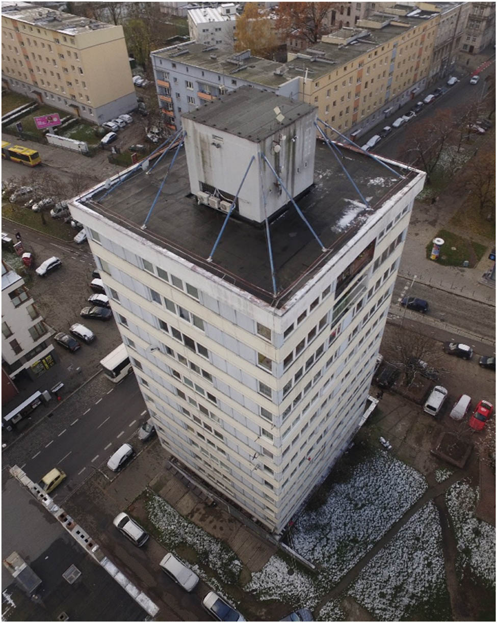
The subject of the study was the “Trzonolinowiec” building (The Cable-Supported House), located in Wroclaw. It is a building with 12 floors above ground, a full basement, and 44 apartments. Figure 1 shows the analyzed building.

View of the “Trzonolinowiec” (The Cable-Supported House), photo by M. Szóstak.
On the ground floor is the technical floor, while above the roof level, in the contour of the building’s core, the elevator machine room is located. The entire building has dimensions in outline of 15.3 × 15.3 m and an overall height of 40.30 m. The basic load-bearing elements of the building are
Reinforced concrete core and a system of 12 steel cables. The core is 42.0 m high, and its outer dimensions are 5.10 × 5.10 m. It was founded on a 1.20 m thick 12.0 × 12.0 m base slab.
The steel cables are anchored to the core’s top edge, and their cross section varies from 127 steel strands ϕ5 mm on the topmost story to 19 steel strands ϕ5 mm on the bottommost story.
The prefabricated triangular load-bearing floor slabs are 4 cm thick and have the dimensions: 2.4 × 4.3 m and 2.35 × 4.2 m. They are strengthened with 19 × 4 cm ribs. The slabs were on-site monolithically integrated into four-piece squares and their one edge or corner on one side was rested on the core, whereas their other corners were suspended using steel cables.
A reinforced concrete elevator shaft and stairwell, as well as a trash chute shaft, connected to the shaft and plumbing shafts, are located in the core of the building. The ceilings of the floor joists are monolithic reinforced concrete. These elements are an integral part of the shaft.
The building was constructed according to an innovative method that combines monolithic and pre-fabricated reinforced concrete structures with the technology of sliding and lifting ceilings suspended on tendons. First, an underground basement floor was constructed, and a foundation slab was prepared for the core, which is the basic element of the triple-link support system. The shaft was erected on a sliding formwork. After the load-bearing walls of the shaft were completed in one story, the formwork was moved up one story. At the same time, with the help of hydraulic levers, the assembly head was lifted, and with it, the floor slabs of the subsequent floors, which had been monolithized at the first-floor level, were pulled up on 12 steel cables. Steel cables were run through holes in the slabs so that each had one end under the lowest slab and the other was attached to a head placed on the top, last slab. Successive “layers” of slabs were supported at successive levels of the shaft, which were poured on an ongoing basis. After all residential floors were completed, the entire structure was raised one more floor by pouring the lowest floor part of the shaft. Once the building was lifted, the cables (tendons) were tightened and anchored to the foundation and head.
A major renovation of the building was carried out in 1975–1976. The purpose of the renovation was to stiffen the structure in view of the excessive vibrations of the building under the wind loads that were found. The vertical sections of the supporting cables were constructed with reinforced concrete columns (column cross section 25 × 25 centimeters) was carried out, with the aim of changing the suspension of the slabs in the cables to their support in the columns mentioned above. In the first-floor and basement sections, the cables were encased in steel profiles. The anchoring of the steel column housings was done at the basement level in reinforced concrete pedestals fastened with a perimeter ring.
After decades of use and neglect due to a lack of current and maintenance repairs, the building has reached a state of threatened failure, which means that at any time, there may be a structural failure (structural collapse) that threatens the life and health of residents [35].
The building inventory was intended to gather information about the current state of the building, as the archival design documentation proved to be incomplete and outdated due to significant changes in the building’s structure since its construction. Therefore, to develop a BIM model of the building, to carry out static and strength calculations, verification measurements of the building’s geometry were taken. Measurements included:
the length and thickness of the walls;
the height of rooms;
the height, thickness, and length of stringers, beams, ceilings, and cavities;
the length, thickness, location, and angle of ropes, etc.
The completed inventory provided information on the dimensions of the building, the number of floors, the layout of the rooms, their purpose, and the location of the passageways. Damage in the form of cracks, fractures, and cavities was also identified. A BIM model was created based on the verification and design documentation.
The facility’s BIM model provides the basis for integrating a variety of data sources, such as laser scans, photogrammetry data, and analysis performed in VR. The use of drones makes it possible to acquire precise photogrammetric data, even in areas that are difficult to reach, such as building facades. Combining these data with a BIM model makes it possible to overlay and synchronize them, which not only increases the accuracy of the object’s representation, but also allows for more detailed technical analyses.
The integration of photogrammetric data acquired by UAVs with the BIM model is a key element of the proposed approach aimed at obtaining accurate documentation of the site and streamlining the inventory process. The workflow for this process involves acquiring the images, processing them in specialized photogrammetric software into a point cloud and then importing the data into a BIM model. The use of specialized software allows for accurate mapping of building geometry and subsequent integration into the BIM. However, the process presents challenges, especially in ensuring that the data are compatible and fit precisely into the existing BIM model. Another challenge is the large amount of data generated by photogrammetry, which requires efficient tools to manage and store the information.
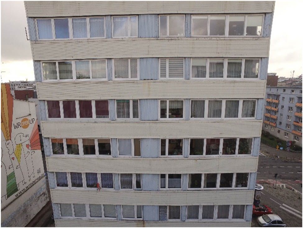
The overlay of photogrammetric data on a BIM model is an important step in creating a digital twin of a building. This will provide a virtual representation of the actual state that allows the monitoring of changes over time [36]. The resulting 3D model can then be settled into a VR environment, allowing inspectors and specialists to interactively view the building. In this way, inspectors can visually identify damage, such as cracks, dilation, or other deformations, based on precisely superimposed photogrammetric data. This is possible through the use of VR goggles and manual controllers. The interactive environment in which the data will be embedded allows the user to zoom in on selected portions of the photos and to mark directly on the digital element a remark about the location. In the classic approach, a photo would be included in the protocol along with a description of the remark; in the proposed approach, the remark is pinned directly to the location of the remark in the virtual world. The virtual world becomes a reference to which all users of the created environment can refer. The most important advantage is that there is no need for a description of the location, because, as mentioned earlier, the remark is located (pinned) directly to the place in question. Inspectors not only can visually assess the condition of the facility in real time, but can also analyze changes over time by comparing successive drone raids and updating the data in the BIM model. This process allows for accurate monitoring and rapid response to emerging structural hazards, which is crucial for building safety management. Figures 2 and 5 show the effects of the photogrammetric documentation acquired through the drone raid, compared to the 3D model made (Figures 3–5).
View of the elevations northeast.

Model view of the elevations northeast.
North elevation.

North elevation in the model.
6 Limitations and future directions of research
While the survey methodology presented to build inventory using modern digital technologies and BIM modeling has its advantages, there are also some limitations that may limit its widespread use.
One key limitation is the training requirements associated with the introduction of advanced technologies such as laser scanning and photogrammetry. The need to train personnel on the use of modern equipment and software for data analysis and processing is an important element that can affect the effectiveness of the implementation of these methods. In addition, the cost of equipment is a significant factor that can be a barrier for many companies, especially smaller ones, to invest in modern technologies. The high outlay for purchasing a laser scanner, drones, or software may be out of reach for some companies, ultimately limiting their ability to adopt innovative solutions. Data management is also a challenge. Generating large amounts of information through modern inventory methods requires effective strategies for data storage, processing, and analysis. Without adequate solutions in this area, the usability and security of the information collected may be compromised.
In turn, when analyzing future research directions, it is worth focusing on several key directions that can significantly affect the development of building inventory methods. The first direction is the integration of various nondestructive testing methods. Incorporating techniques such as thermography, ultrasound, or microwave analysis into the inventory process could increase the accuracy of the analysis of the technical condition of buildings. When data obtained from different sources are combined, it would be possible to obtain a more complete picture of the technical condition of buildings. Another promising direction is the application of machine learning techniques for automatic damage detection. Using artificial intelligence algorithms to analyze inventory data could speed up the process of identifying problem areas and improve the precision of diagnosis. Implementing such solutions would also make it possible to monitor the technical condition of the facilities in real time, which in turn could contribute to more efficient management. Additionally, it would be worthwhile to analyze the effectiveness of using different scanning technologies, such as LiDAR or photogrammetry, in the context of different types of buildings, including historic monuments, and to analyze how differences in building construction can affect the effectiveness of the technologies used.
7 Conclusion
Inventory is one of the basic activities during building expertise, the performance of which is becoming more common. This is due to the aging of buildings and the need to maintain them in good condition. Currently, the most commonly used method is the traditional method, which is gradually being displaced by modern digital methods such as laser scanning, the use of unmanned aerial vehicles, BIM technology, and VR. Thanks to the possibility of acquiring in a short time, a large amount of precise data, it is possible to reproduce the object very accurately and faithfully in the form of point clouds. Based on the data collected, it is possible to make BIM models, which can be saturated with additional information obtained from the inventory. LiDAR technology, together with photogrammetry, is complementary technologies in terms of the possibility of using data in VR.
-
Funding information: The work was supported by the Minigrants for Doctoral Students project of the Wroclaw University of Science and Technology.
-
Author contributions: All authors have accepted responsibility for the entire content of this manuscript and consented to its submission to the journal, reviewed all the results, and approved the final version of the manuscript. MN: conceptualization, carrying out research and developing results, methodology, writing, visualization, interpretation; MS: carrying out research and developing results, methodology, writing – reviewing and editing, interpretation; KS: methodology, writing – reviewing and editing, guidance, critical revision; AK: carrying out research.
-
Conflict of interest: Authors state no conflict of interest.
-
Data availability statement: The datasets generated during and analyzed during the current study are available from the corresponding author on reasonable request.
References
[1] The Act Of 7 July 1994, Construction Law, in Polish: Ustawa z dnia 7 lipca 1994 r. – Prawo budowlane (Dz.U. 1994 nr 89 poz. 414, z późn. zm.).Search in Google Scholar
[2] Drobek K, Szostak B, Królikowski W. Stocktaking methods of facilities in a state of ruin (in Polish). Bud i Architektura. 2018;17(4):5–15. 10.24358/Bud-Arch_18_174_01.Search in Google Scholar
[3] Li J, Hou L, Wang X, Wamd J, Guo J, Zhang S, et al. A project-based quantification of BIM benefits. Int J Adv Rob Syst. 2014;11(8):123. 10.5772/58448.Search in Google Scholar
[4] Szóstak M, Kierski P. Application of 3D laser scanning technology in the inventory of existing buildings. Zastosowanie technologii skanowania laserowego 3D w inwentaryzacji istniejących obiektów budowlanych (in Polish). Builder. 2023;312(7):2–5. 10.5604/01.3001.0053.6976.Search in Google Scholar
[5] Borkowski A, Kubrat A. Integration of laser scanning, digital photogrammetry and BIM technology: A review and case studies. Eng. 2024;5:2395–409. 10.3390/eng5040125.Search in Google Scholar
[6] Skrzypczak I, Oleniacz G, Leśniak A, Zima K, Mrówczyńska M, Kazak J. Scan-to-BIM method in construction: assessment of the 3D buildings model accuracy in terms inventory measurements. Build Res Inf. 2022;50(8):859–80. 10.1080/09613218.2021.2011703.Search in Google Scholar
[7] Somanath S, Naserentin V, Eleftheriou O, Sjölie D, Wästberg B, Logg A. Towards urban digital twins: A workflow for procedural visualization using geospatial data. Remote Sens. 2024;16(11):1939. 10.3390/rs16111939.Search in Google Scholar
[8] Pikulski P, Marek A. Laser scanning as the most accurate method of inventorying historical objects – analysis using the example of the Samuel Maciejowski Palace in Krakow. Skaning laserowy jako najdokładniejsza metoda inwentaryzacji obiektów zabytkowych – analiza na przykładzie pałacu Samuela Maciejowskiego w Krakowie (in Polish). Przestrzeń Urbanistyka Architektura. 2023;1:21–30. 10.37705/PUA/1/2023/02.Search in Google Scholar
[9] Tse R, Gold C, Kidner D. 3D city modelling from LIDAR data. Advances in 3D geoinformation systems. Berlin, Heidelberg: Springer 2008. p. 161–75.10.1007/978-3-540-72135-2_10Search in Google Scholar
[10] Kuznetsova I, Kuznetsova D, Rakova X. The use of surface laser scanning for creation of a three-dimensional digital model of monument. Procedia Eng. 2015;100:1625–33. 10.1016/j.proeng.2015.01.536.Search in Google Scholar
[11] Grasso N, Spadavecchia C, Di Pietra V, Belcore E. LiDAR and SfM-MVS integrated approach to build a highly detailed 3D virtual model of urban areas. Proceedings of the 9th International Conference on Geographical Information Systems Theory, Applications and Management (GISTAM 2023). SCITEPRESS - Science and Technology Publications; 2023. p. 128–35. 10.5220/0011760800003473.Search in Google Scholar
[12] Kim S, Kim S, Lee D-E. Sustainable application of hybrid point cloud and BIM method for tracking construction progress. Sustainability. 2020;12(10):4106. 10.3390/su12104106.Search in Google Scholar
[13] Pricope N, Halls J, Mapes K, Baxley J, Wu J. Quantitative comparison of UAS-borne LiDAR systems for high-resolution forested wetland mapping. Sensors. 2020;20(16):4453. 10.3390/s20164453.Search in Google Scholar PubMed PubMed Central
[14] Tysiac P, Wojtowicz A, Szulwic J. Coastal cliffs monitoring and prediction of displacements using terrestial laser scanning. Baltic Geodetic Congress (BGC Geomatics). IEEE; 2016. p. 61–6. 10.1109/BGC.Geomatics.2016.20.Search in Google Scholar
[15] Bobkowska K, Inglot A, Mikusova M, Tysiąc P. Implementation of spatial information for monitoring and analysis of the area around the port using laser scanning techniques. Pol Marit Res. 2017;24(s1):10–5. 10.1515/pomr-2017-0015.Search in Google Scholar
[16] Arayici Y. Towards building information modelling for existing structures. Struct Surv. 2008;26(3):210–22. 10.1108/02630800810887108.Search in Google Scholar
[17] Tshering P, Saeed B, Aso H, Golzad H. Heritage building information modeling (HBIM) for heritage conservation: Framework of challenges, gaps, and existing limitations of HBIM. Digital Appl Archaeol Cultural Herit. 2024;35:e00366. 10.1016/j.daach.2024.e00366.Search in Google Scholar
[18] Yahya A, Ahmad B. Integration of photogrammetry and laser scanning for enhancing scan-to-HBIM modeling of Al Ula heritage site. Herit Sci. 2023;11:147.10.1186/s40494-023-00997-2Search in Google Scholar
[19] Sanhudo L, Ramos N, Martins J, Almeida R, Barreira E, Simões M, et al. A framework for in-situ geometric data acquisition using laser scanning for BIM modelling. J Build Eng. 2020;28:101073. 10.1016/j.jobe.2019.101073.Search in Google Scholar
[20] Rashdi R, Martínez-Sánchez J, Arias P, Qiu Z. Scanning technologies to building information modelling: A review. Infrastructures. 2022;7(4):49. 10.3390/infrastructures7040049.Search in Google Scholar
[21] Shanoer M, Abed F. Evaluate 3D laser point clouds registration for cultural heritage documentation. Egypt J Remote Sens Space Sci. 2018;21(3):295–304. 10.1016/j.ejrs.2017.11.007.Search in Google Scholar
[22] Barazzetti L, Banfi F, Brumana R, Previtali M. Creation of parametric BIM objects from point clouds using nurbs. Photogramm Rec. 2015;30(152):339–62. 10.1111/phor.12122.Search in Google Scholar
[23] Jasińska D, Dutkiewicz M. 3D scanning as a method of inventorying revitalized facilities – a case study of the 19th-century Rother Mills in Bydgoszcz. Skaning 3D jako metoda inwentaryzacji rewitalizowanych obiektów –studium przypadku XIX-wiecznych Młynów Rothera w Bydgoszczy (in Polish). Builder. 2024;319(2):22–5.10.5604/01.3001.0054.2819Search in Google Scholar
[24] Kholodkov A, Matysik K, Matysik M, Szulwic J, Wojtowicz A, Tysiąc P. Marine laser scanning of sports infrastructure on the example of the port in Władysławowo. Morski skaning laserowy infrastruktury portowej na przykładzie portu we Władysławowie (in Polish). Logistyka. 2014;6:4317–28.Search in Google Scholar
[25] Ha Y, Kim Y, Pham M, Park H, Oh M. Fabrication and assessment of port block pavement based on the deflection and settlement characteristic. Case Stud Constr Mater. 2024;20:e03284.10.1016/j.cscm.2024.e03284Search in Google Scholar
[26] Pawłowicz J, Szafranko E, Harasymiuk J. 3D laser scanning in civil engineering - measurements of volume of earth masses. IOP Conf Ser: Mater Sci Eng. 2018;324:012005. 10.1016/j.cscm.2024.e03284.Search in Google Scholar
[27] Borkowski A, To Duc A. Integration of BIM and GIS data of a heritage building using FME. Civ Environ Eng Rep. 2024;34(2):204–15. 10.59440/ceer/190231.Search in Google Scholar
[28] Herle S, Becker R, Wollenberg R, Blankenbach J. GIM and BIM. PFG – J Photogramm Remote Sens Geoinf Sci. 2020;88(1):33–42.10.1007/s41064-020-00090-4Search in Google Scholar
[29] Stefańska A, Markowski H, Dixit S. Three-dimensional laser scanning for structure documentation and construction management: A case study of renovation and rebuilt of metro tunnels. Ain Shams Eng J. 2024;15(5):102665. 10.1016/j.asej.2024.102665.Search in Google Scholar
[30] Quoc H, Thi H, Ngoc M, Dieu H. Optimize retail system performance by analyzing big data and visualizing with power BI. Int J Intell Syst Appl Eng. 2024;12(11):396–405, https://ijisae.org/index.php/IJISAE/article/view/4460.Search in Google Scholar
[31] Szóstak M, Napiórkowski M, Schabowicz K. Application of the virtual reality in the construction industry in terms of health and safety training - state of the art. Zastosowanie wirtualnej rzeczywistości w budownictwie w aspekcie szkoleń w zakresie bezpieczeństwa i higieny pracy – stan wiedzy (in Polsih). Przegląd Budowlany. 2024;95(4):128–30. 10.5604/01.3001.0054.6401.Search in Google Scholar
[32] Omer M, Margetts L, Hadi Mosleh M, Hewitt S, Parwaiz M. Use of gaming technology to bring bridge inspection to the office. Struct Infrastruct Eng. 2019;15(10):1292–307. 10.1080/15732479.2019.1615962.Search in Google Scholar
[33] Rehbein J, Lorenz S, Holtmannspötter J, Valeske B. 3D-visualization of ultrasonic NDT data using mixed reality. J Nondestr Eval. 2022;41(1):26.10.1007/s10921-022-00860-7Search in Google Scholar
[34] Ababsa F. Augmented reality application in manufacturing industry: Maintenance and non-destructive testing (NDT) use cases. Augmented reality, virtual reality, and computer graphics. Cham: Springer; 2020. p. 333–44.10.1007/978-3-030-58468-9_24Search in Google Scholar
[35] Schabowicz K, Berkowski P, Dmochowski G, Gorzelańczyk T, Noszczyk P, Szóstak M, et al. Survey report concerning the condition of structural components in a residential building at 72 Kosciuszko Street in Wroclaw, determining deficiencies in this condition and a way of remedying them in accordance with the standards specified by the County Building Control Office (PINB) – the duty contained in PINB decision No. 183/2022 (in Polish). Civ Eng Fac Rep Ser. 2024. Ser. SPR, No.1:1–129.Search in Google Scholar
[36] Levenberg E, Barisic L. A digital twin concept for civil infrastructure. J Infrastruct Syst. 2024;30(4). 10.1061/JITSE4.ISENG-2431.Search in Google Scholar
© 2025 the author(s), published by De Gruyter
This work is licensed under the Creative Commons Attribution 4.0 International License.
Articles in the same Issue
- Research Articles
- Modification of polymers to synthesize thermo-salt-resistant stabilizers of drilling fluids
- Study of the electronic stopping power of proton in different materials according to the Bohr and Bethe theories
- AI-driven UAV system for autonomous vehicle tracking and license plate recognition
- Enhancement of the output power of a small horizontal axis wind turbine based on the optimization approach
- Design of a vertically stacked double Luneburg lens-based beam-scanning antenna at 60 GHz
- Synergistic effect of nano-silica, steel slag, and waste glass on the microstructure, electrical resistivity, and strength of ultra-high-performance concrete
- Expert evaluation of attachments (caps) for orthopaedic equipment dedicated to pedestrian road users
- Performance and rheological characteristics of hot mix asphalt modified with melamine nanopowder polymer
- Second-order design of GNSS networks with different constraints using particle swarm optimization and genetic algorithms
- Impact of including a slab effect into a 2D RC frame on the seismic fragility assessment: A comparative study
- Analytical and numerical analysis of heat transfer from radial extended surface
- Comprehensive investigation of corrosion resistance of magnesium–titanium, aluminum, and aluminum–vanadium alloys in dilute electrolytes under zero-applied potential conditions
- Performance analysis of a novel design of an engine piston for a single cylinder
- Modeling performance of different sustainable self-compacting concrete pavement types utilizing various sample geometries
- The behavior of minors and road safety – case study of Poland
- The role of universities in efforts to increase the added value of recycled bucket tooth products through product design methods
- Adopting activated carbons on the PET depolymerization for purifying r-TPA
- Urban transportation challenges: Analysis and the mitigation strategies for road accidents, noise pollution and environmental impacts
- Enhancing the wear resistance and coefficient of friction of composite marine journal bearings utilizing nano-WC particles
- Sustainable bio-nanocomposite from lignocellulose nanofibers and HDPE for knee biomechanics: A tribological and mechanical properties study
- Effects of staggered transverse zigzag baffles and Al2O3–Cu hybrid nanofluid flow in a channel on thermofluid flow characteristics
- Mathematical modelling of Darcy–Forchheimer MHD Williamson nanofluid flow above a stretching/shrinking surface with slip conditions
- Energy efficiency and length modification of stilling basins with variable Baffle and chute block designs: A case study of the Fewa hydroelectric project
- Renewable-integrated power conversion architecture for urban heavy rail systems using bidirectional VSC and MPPT-controlled PV arrays as an auxiliary power source
- Exploitation of landfill gas vs refuse-derived fuel with landfill gas for electrical power generation in Basrah City/South of Iraq
- Two-phase numerical simulations of motile microorganisms in a 3D non-Newtonian nanofluid flow induced by chemical processes
- Sustainable cocoon waste epoxy composite solutions: Novel approach based on the deformation model using finite element analysis to determine Poisson’s ratio
- Impact and abrasion behavior of roller compacted concrete reinforced with different types of fibers
- Architectural design and its impact on daylighting in Gayo highland traditional mosques
- Structural and functional enhancement of Ni–Ti–Cu shape memory alloys via combined powder metallurgy techniques
- Design of an operational matrix method based on Haar wavelets and evolutionary algorithm for time-fractional advection–diffusion equations
- Design and optimization of a modified straight-tapered Vivaldi antenna using ANN for GPR system
- Analysis of operations of the antiresonance vibration mill of a circular trajectory of chamber vibrations
- Functions of changes in the mechanical properties of reinforcing steel under corrosive conditions
- Enhanced PAPR reduction in NOMA systems using modified SLM and PTS techniques for power-efficient 5G and beyond networks
- Hybrid mechanics-informed machine learning models for predicting mechanical failure in graphene sponge: a low-data strategy for mechanical engineering applications
- Design of shafts of a two-piece chain conveyor as a part of a modification of a mobile working machine
- Review Articles
- A modified adhesion evaluation method between asphalt and aggregate based on a pull off test and image processing
- Architectural practice process and artificial intelligence – an evolving practice
- 10.1515/eng-2025-0148
- Special Issue: 51st KKBN - Part II
- The influence of storing mineral wool on its thermal conductivity in an open space
- Use of nondestructive test methods to determine the thickness and compressive strength of unilaterally accessible concrete components of building
- Use of modeling, BIM technology, and virtual reality in nondestructive testing and inventory, using the example of the Trzonolinowiec
- Tunable terahertz metasurface based on a modified Jerusalem cross for thin dielectric film evaluation
- Integration of SEM and acoustic emission methods in non-destructive evaluation of fiber–cement boards exposed to high temperatures
- Non-destructive method of characterizing nitrided layers in the 42CrMo4 steel using the amplitude-frequency technique of eddy currents
- Evaluation of braze welded joints using the ultrasonic method
- Analysis of the potential use of the passive magnetic method for detecting defects in welded joints made of X2CrNiMo17-12-2 steel
- Analysis of the possibility of applying a residual magnetic field for lack of fusion detection in welded joints of S235JR steel
- Eddy current methodology in the non-direct measurement of martensite during plastic deformation of SS316L
- Methodology for diagnosing hydraulic oil in production machines with the additional use of microfiltration
- Special Issue: IETAS 2024 - Part II
- Enhancing communication with elderly and stroke patients based on sign-gesture translation via audio-visual avatars
- Optimizing wireless charging for electric vehicles via a novel coil design and artificial intelligence techniques
- Evaluation of moisture damage for warm mix asphalt (WMA) containing reclaimed asphalt pavement (RAP)
- Comparative CFD case study on forced convection: Analysis of constant vs variable air properties in channel flow
- Evaluating sustainable indicators for urban street network: Al-Najaf network as a case study
- Node failure in self-organized sensor networks
- Comprehensive assessment of side friction impacts on urban traffic flow: A case study of Hilla City, Iraq
- Design a system to transfer alternating electric current using six channels of laser as an embedding and transmitting source
- Security and surveillance application in 3D modeling of a smart city: Kirkuk city as a case study
- Modified biochar derived from sewage sludge for purification of lead-contaminated water
- The future of space colonisation: Architectural considerations
- Design of a Tri-band Reconfigurable Antenna Using Metamaterials for IoT Applications
- Special Issue: AESMT-7 - Part II
- Experimental study on behavior of hybrid columns by using SIFCON under eccentric load
- Special Issue: ICESTA-2024 and ICCEEAS-2024
- A selective recovery of zinc and manganese from the spent primary battery black mass as zinc hydroxide and manganese carbonate
- Special Issue: REMO 2025 and BUDIN 2025
- Predictive modeling coupled with wireless sensor networks for sustainable marine ecosystem management using real-time remote monitoring of water quality
- Management strategies for refurbishment projects: A case study of an industrial heritage building
- Structural evaluation of historical masonry walls utilizing non-destructive techniques – Comprehensive analysis