Potential landslide detection and influencing factors analysis in the upper Yellow River based on SBAS-InSAR technology
-
Jin Zeng
 ,
Xinchao Wang
,
Xinchao Wang

Abstract
This study examined the frequent occurrence of landslide disasters in the upper reaches of the Yellow River (from Gonghe to Xunhua) using Sentinel-1A data from January 2021 to December 2023 and integrating it with small baseline subset interferometric synthetic aperture radar (SBAS-InSAR) technology to extract surface deformation rates and combine optical remote sensing imagery to detect potential landslides. The annual average ground deformation rate in the study area ranged between −139 and 73 mm/a along the ascending track, whereas it exhibited broader variation from −237 to 123 mm/a along the descending track. Through the integration of SBAS-InSAR measurements with optical remote sensing imagery, we successfully identified potential landslides within the research area. Specifically, 171 potential landslides were detected in the ascending track and 154 in the descending track, with 98 overlapping landslides recognized by both datasets. The present study primarily analyzed the influencing factors of the Guobude landslide, which exhibited the fastest deformation rate. A steep slope, low vegetation coverage, and unfavorable lithological mechanical properties were the predominant factors contributing to this landslide. In contrast, precipitation had an insignificant impact on landslide deformation. The multi-temporal InSAR approach, combined with geotechnical evaluation, offers an effective methodology for regional landslide identification and mechanism analysis in complex terrain. This study demonstrates the effectiveness of integrating SBAS-InSAR with optical remote sensing for landslide monitoring, providing a scientific foundation for disaster monitoring, risk assessment, and early warning in the upper Yellow River basin. The findings hold substantial significance for the development of real-time monitoring and early warning systems, the optimization of governance measures, and the promotion of ecological security and high-quality sustainable development in the upper reaches of the Yellow River.
1 Introduction
Landslides predominantly occur due to the instability of slopes influenced by gravity, with major factors affecting them, including slope gradient, vegetation coverage, river erosion, groundwater, precipitation, and human engineering activities [1,2,3]. As one of the most prevalent natural disasters worldwide, landslides pose a significant threat to human life and property in numerous countries each year [4]. According to statistical data, from 2010 to 2022, China experienced a total of 710 fatal landslide events, resulting in 5,158 fatalities [5]. Italian scholars Franceschini et al. reported that between 2010 and 2019, 32,000 landslide incidents affected 42% of Italian cities [6]. Calvello and Pecoraro reported that from 1967 to 2016, landslides in Italy caused 1,205 deaths, left 12 individuals missing, and resulted in 1,509 injuries [7]. Indian scholars reported that landslides in India annually lead to hundreds of fatalities and economic losses amounting to 1.5 billion rupees (approximately 15.3 million euros) [8,9]. Nepalese scholars Sharma et al. reported that from 2011 to 2020, Nepal experienced 2,121 landslide disasters, claiming 1,206 lives [10]. He et al. emphasized that, globally, thousands of people perish annually due to landslide disasters, causing direct economic losses exceeding 3.5 billion euros [11]. Furthermore, from 1995 to 2014, a total of 128 countries reported fatal landslide incidents, leading to 163,658 deaths and 11,689 injuries [12]. Landslides continuously threaten human life and property safety. Consequently, early-stage hazard identification and effective landslide monitoring are of paramount importance.
With the rapid advancement of remote sensing technology, landslide monitoring techniques have significantly improved [13]. Numerous scholars have achieved notable progress in this field. For example, Ghaderpour et al. introduced a sequential turning point detection method (STPD) and compared it with traditional change-point detection methods; their findings demonstrated that STPD outperformed other methods in terms of overall accuracy and root mean square error in estimating the position and direction of trend turns [14]. Additionally, STPD was applied to detect turning points in persistent scatterer interferometric synthetic aperture radar (PS-InSAR) time series for Frosinone Province, Italy. The results confirmed that STPD can estimate turning points in time series more rapidly and accurately, thereby advancing existing landslide monitoring technologies in terms of effectiveness and reliability. Ghaderpour et al. further employed PS-InSAR to examine the relationship between the activation time and velocity of slowly moving landslides in central Italy and precipitation. Their findings demonstrated a strong correlation between the turning points of cumulative precipitation trends and displacement time series [15]. Khan et al. employed small baseline subset interferometric synthetic aperture radar (SBAS-InSAR) to monitor landslides and glaciers along the China–Pakistan Karakoram Highway and calculated an annual deformation rate ranging from 62 to −104 mm/year. The analysis revealed that slope aspect was the primary factor contributing to deformation [16]. Roy et al. monitored Lake South Ronak in Sikkim, India, using SBAS-InSAR technology based on Sentinel-1A descending orbit data and analyzed the influencing factors through optical imagery and digital simulation methods. They concluded that the combined effects of landslide debris collapsing onto the lake surface and glacier disintegration caused a significant rise in water levels along the Lachen River channel. This, in turn, led to downstream flow along the terminal channel, triggering at least 110 landslides as a result of toe cutting [17].
The upper Yellow River section from Gonghe to Xunhua is situated at the transition zone from the Qinghai–Tibet Plateau to the Loess Plateau, primarily flowing through areas such as Longyang Gorge, Guide County, Lijia Gorge, Jianzha Basin, and Xunhua Basin [18]. The upper Yellow River region exhibits a complex geological structure, significant terrain fluctuations, and diverse lithology, making it prone to frequent landslides. For example, the Xijitan landslide in Guide Basin, the Suozi landslide, the Simen Village landslide, and the Xiazangtan landslide in Jianzha County [19,20,21,22]. As the residents of the Gonghe to the Xunhua section of the upper Yellow River primarily live along both sides of the Yellow River [23], any landslide poses a serious threat to the lives and property of the residents. Therefore, early identification and detection of potential landslides in the upper Yellow River is crucial.
The upper reaches of the Yellow River feature complex terrain and traditional measurement techniques such as precise leveling, global navigation satellite system (GNSS), and geophysical exploration are effective for small-scale monitoring but not for large-scale monitoring [24,25], making it challenging to achieve full-range, all-weather monitoring. However, the interferometric synthetic aperture radar (InSAR) technology offers advantages such as all-weather capability, high precision, strong penetration, non-contact operation, wide coverage, and continuous monitoring of surface deformation. Therefore, it has been widely used in landslide monitoring [26]. SBAS-InSAR was introduced by Italian researchers Berardino and others in 2002 [27]. It is a surface deformation monitoring technology based on InSAR and addresses the issue of phase discontinuity attributed to large baselines in traditional InSAR technology by minimizing the spatial and temporal baselines.
Currently, several researchers have adopted InSAR technology to monitor and identify landslides in the upper reaches of the Yellow River. For example, Zhao et al. employed SBAS-InSAR technology to identify 355 potential landslides in the Longyang Gorge to Liujia Gorge section of the upper reaches of the Yellow River. Additionally, field investigation in combination with optical image analysis was used to identify the Xijitan landslide and Suozhi landslide, which were in the stable creep and fluctuating creep stages, respectively [28]. Tu et al. employed stacking-InSAR and IPTA technology to monitor the landslide from Longyang Gorge to Lijia Gorge section, with the overlap rate of the two methods being 97.08%. They concluded that precipitation had a negligible impact on the stability of the Lijia Gorge slope, as the change in the deformation rate of the Lijia Gorge landslide group before and after the precipitation was minimal [29]. Zhu employed stacking-InSAR technology to identify landslide hazard areas in Jianzha County. They identified 39 landslide areas by integrating optical images with a deformation rate threshold of 20 mm/a [30]. Fei et al. employed DS-InSAR technology and the IPTA method for the identification of unstable slopes and monitoring deformation in the Longyang Gorge reservoir area of the Yellow River upstream, thereby identifying 15 unstable slopes [31]. Yue et al. integrated PS-InSAR technology and SBAS-InSAR technology to determine the maximum deformation rates in the Xiazangtan landslide in Jianzha County, which is situated in the upper reaches of the Yellow River, from 2017 to 2022. The rates in the uplift and subsidence directions were 24 and 21 mm/a, with maximum cumulative deformation of 133 and 128 mm, respectively [32].
In previous studies, Zhao et al. only employed ascending Sentinel-1A data to identify potential landslides in the upper reaches of the Yellow River. However, the flight direction and radar incidence angle of the SAR satellite affect the accuracy of the results from a single orbit, and the complex topographic conditions in this region increase the likelihood of misjudgment and omission. Tu et al. did not consider geological strata and slope angle, two important factors influencing landslide deformation, in their analysis of the factors affecting landslide deformation. In addition, other researchers only monitored landslides in local areas of the upper reaches of the Yellow River and failed to achieve large-scale landslide monitoring. Therefore, this article combines advanced landslide monitoring technology to overcome the limitations of existing research on landslide monitoring in the upper reaches of the Yellow River. The main contributions of this article are as follows:
This study considered ascending and descending Sentinel-1A data from January 2021 to December 2023 to extract the average annual ground deformation rate on the surface of the study area. Additionally, it employed SBAS-InSAR technology in combination with optical remote sensing imagery to identify and detect potential landslides and map their spatial distribution.
To evaluate the factors affecting the deformation of the Guobude landslide in the upper reaches of the Yellow River, this study integrated SBAS-InSAR technology ground deformation data with slope, monthly precipitation, vegetation coverage, and geological strata.
The study converted the ground deformation rate in the line-of-sight (LOS) direction from both ascending and descending tracks into the east-west, north-south, and vertical components to provide a more accurate depiction of the surface deformation characteristics of the Guobude landslide.
In this study, we conducted comprehensive monitoring and identification of potential landslides in the upper Yellow River basin through the integrated application of SBAS-InSAR technology and optical images. A systematic analysis was conducted to investigate the key factors influencing landslide deformation mechanisms. The findings provide valuable references for landslide risk prevention and comprehensive geological hazard management in this ecologically sensitive region. The structure of the article is organized as follows. Section 2 introduces the geographical characteristics of the study area, data acquisition protocols, the SBAS-InSAR methodology, and the three-dimensional deformation inversion framework. Section 3 presents the analytical results, including annual average surface displacement rates across the study area, spatial distribution patterns of identified potential landslides, and the three-dimensional deformation characteristics of the Guobude landslide derived from inversion modeling. Section 4 analyzes the dominant controlling factors influencing the Guobude landslide deformation through comparative analysis with previous studies, and discusses methodological limitations and directions for future research. Section 5 presents the conclusions.
2 Materials and methods
2.1 Research area
The upper reaches of the Yellow River (from Gonghe to Xunhua) are situated in the southeastern part of the Qinghai-Tibet Plateau, with high terrain in the west, north, and south, and low terrain in the east and west. The elevation ranges from 1,640 to 4,945 m, as shown in Figure 1. The geological strata and rock types in the study area are relatively complex, predominantly comprising Quaternary to Holocene fine-grained quartz sandstone and the upper Middle Pleistocene loess; Neogene sandstone, gravel, mudstone, and shale; Paleogene-Neogene mudstone and sandstone; the lower Middle Pleistocene claystone, sandstone, and sand and gravel layers; and granodiorite and biotite diorite, among others [33,34,35,36]. According to the rock and soil mechanical properties, the above rock types are categorized from strong to weak as hard, moderately hard, moderately soft, and soft layers [28], as shown in Figure 5. The study area has a plateau continental climate, with an average annual precipitation of 300–580 mm [37,38]. Most of the precipitation occurs from June to September, accounting for about 80% of the annual precipitation [28]. From the Google Earth images, it can be observed that the study area has sparse vegetation, with relatively significant land desertification. The relatively fragile ecological environment has resulted in frequent landslides in the upper reaches of the Yellow River (from Gonghe to Xunhua). This has garnered widespread attention from scholars and prompted comprehensive research on the occurrence and development patterns of landslides and their influencing factors. This provides a scientific basis for formulating scientific and effective disaster prevention and reduction measures.
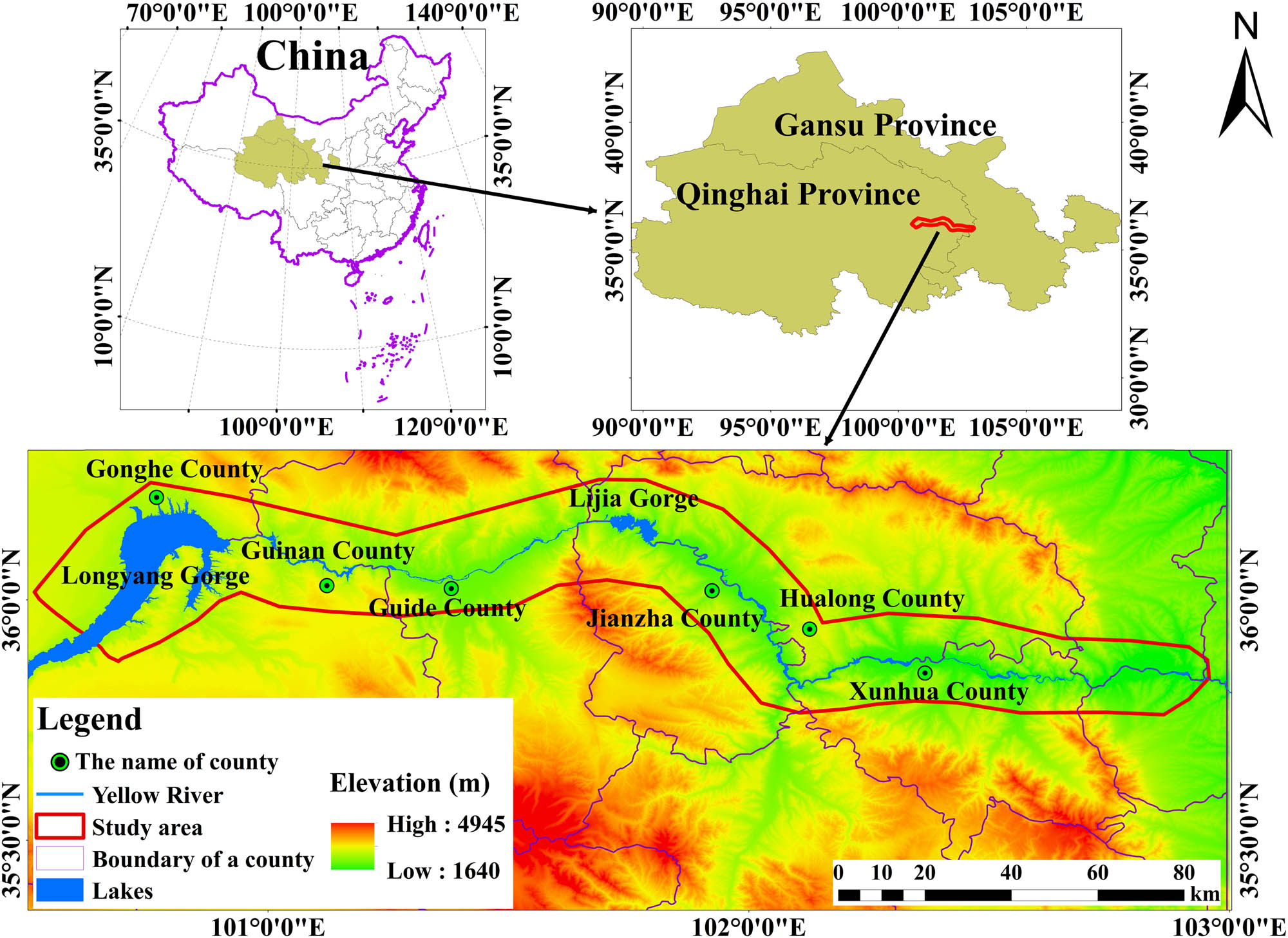
Overview of the study area.
2.2 Data source
This study employed Sentinel-1A ascending and descending orbit data from January 2021 to December 2023, with a total of 123 ascending and 149 descending scenes. The specific parameters of the data are shown in Table 1. To reduce the impact of orbital error, the study utilized SRTM external elevation data at 30 m resolution, as well as precise orbit data (both provided by the European Space Agency: https://vertex.daac.asf.alaska.edu/). The 1:50 million geological lithology data were primarily obtained from the China Geological Survey, and the monthly cumulative precipitation data from January 2021 to December 2023 were mainly obtained from the National Tibetan Plateau Science Data Center (https://data.tpdc.ac.cn/).
The sentinel-1A image parameters
| Satellite | Polarization | Start | End | Path ID | Track | Incident angle | Number of scenes |
|---|---|---|---|---|---|---|---|
| Sentinel-1A | VV + VH | 2021-01 | 2023-12 | 26 | Ascending | 42.8055 | 65 |
| 2021-01 | 2023-12 | 128 | Ascending | 39.1655 | 58 | ||
| 2021-01 | 2023-07 | 33 | Descending | 37.4128 | 70 | ||
| 2021-01 | 2023-06 | 135 | Descending | 31.4646 | 79 |
2.3 Methods
2.3.1 SBAS-InSAR
SBAS-InSAR technology involves capturing a time series of N + 1 ordered SAR images (
Among them, 1 ≤ j ≤ M;
In equation (2),
In equation (3),
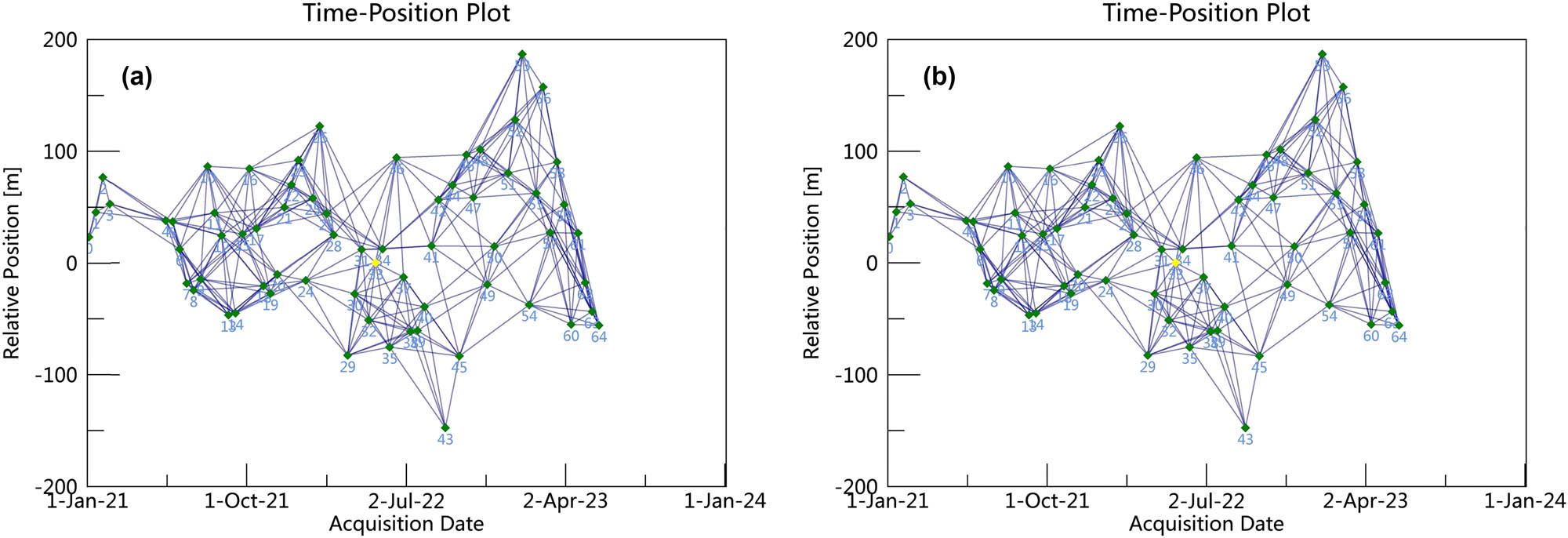
Spatiotemporal baseline connection diagram of the SAR image: (a) direction of ascending and (b) direction of descending.
2.3.2 Inversion of 3D displacements
As SBAS-InSAR technology can only measure the deformation rate of the target point along the radar’s LOS direction [49], to effectively determine the deformation characteristics of landslides, the deformation rate in the LOS direction can be interpolated to the east–west, north–south, and vertical directions [50]. Generally, reconstructing the three-dimensional deformation rate field requires multiple data sources to ensure the accuracy of the inversion results. The maximum difference between ascending and descending SAR satellite imaging corresponds to the angle of radar electromagnetic beam incidence and the azimuth angle of the satellite’s flight direction [51,52]. Building on this feature, this study integrated the data from ascending and descending orbits to construct a three-dimensional decomposition model for surface deformation monitoring results. As SAR satellites operate in a near-polar orbit with a side-looking imaging mode, the LOS direction deformation observations are largely insensitive to north–south deformation information during the three-dimensional decomposition process and are most sensitive to vertical deformation [53,54]. Therefore, in this study, the vertical deformation rate was ignored, and the three-dimensional decomposition equation was expressed as [55] (Figure 3)
In equation (4),
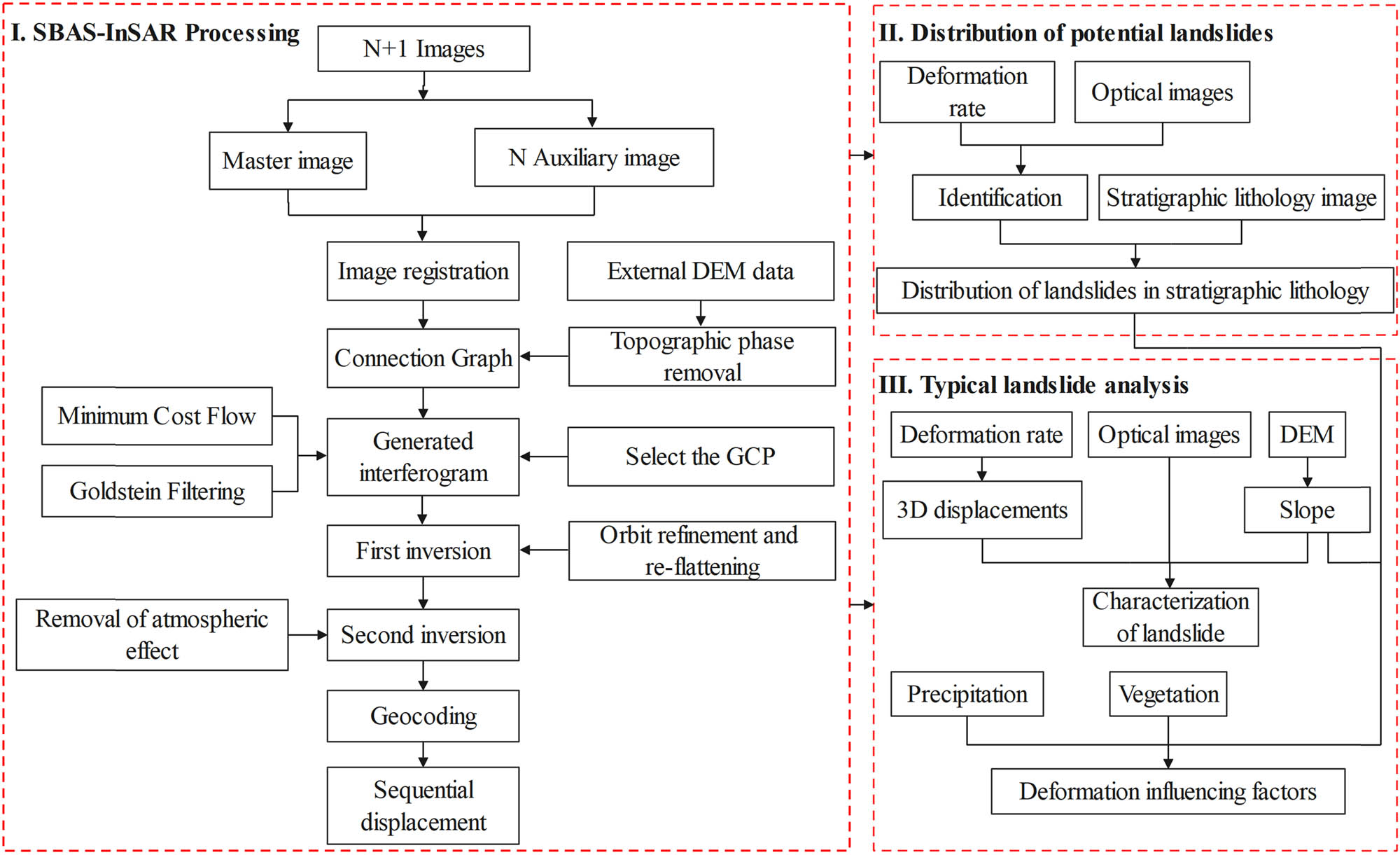
Framework of potential landslide detection and deformation analysis.
3 Results and analysis
3.1 Analysis of SBAS-InSAR results
This study employed SBAS-InSAR technology to calculate and extract the annual average ground deformation rates in the upper reaches of the Yellow River (i.e., from Gonghe to Xunhua) for 2021 and 2023 on both ascending and descending tracks, as shown in Figure 4. It can be observed that most areas in the study region are relatively stable, with significant local deformation rates due to landslides and human engineering activities. In Figure 4, it can be observed that the areas with higher deformation rates are primarily distributed in Guide County, Jianzha County, Hualong County, and the north of Lijia Gorge. The landslides in the upper reaches of the Yellow River are frequent in these areas. The annual average speed of LOS on the ascending track is −139 to 73 mm/a, while the annual average speed of LOS on the descending track is −237 to 123 mm/a. The positive value indicates that the target object in the LOS direction approaches the satellite, and the negative value indicates that the target object in the LOS direction moves away from the satellite.
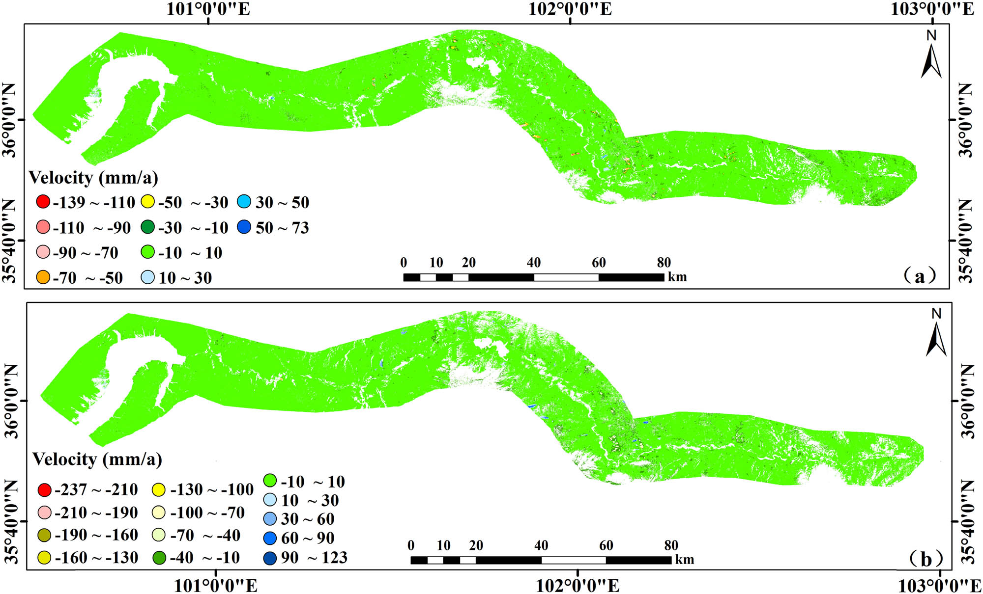
Average annual deformation rate in the study area: (a) displacement rate in the ascending LOS direction and (b) displacement rate in the descending LOS direction.
The above SBAS-InSAR calculation results integrated with the geological strata of the study area are shown in Figure 5. It can be observed that a total of 171 potential landslides are identified in the ascending direction, 154 in the descending direction, and a total of 98 in both directions. Among these landslides, only 18 potential landslides are located on a strong stratum, 19 on hard rocks, and 117 on soft and weak rocks in the ascending track direction. On the contrary, in the descending track direction, 20 potential landslides are located on a strong stratum, 25 on hard rocks, and 109 on soft and weak rocks. This result suggests that the geological strata in the study area are of poor quality, with rock and soil bodies exhibiting lower shear strength, making them more susceptible to deformation and sliding under external forces.
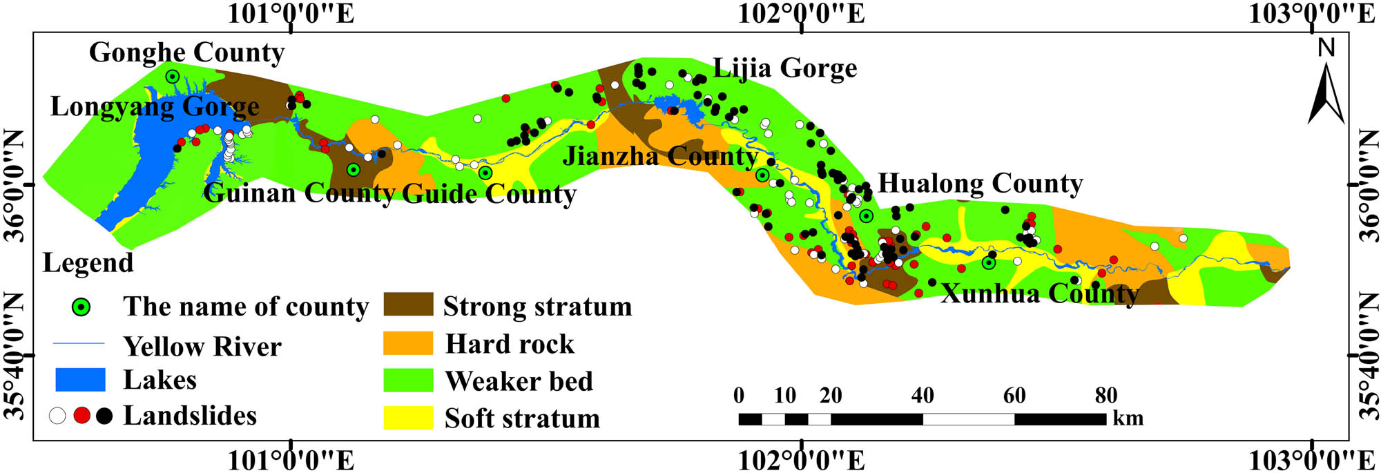
Distribution of potential landslides in different stratigraphic lithologies. The white dots indicate potential landslides identified by InSAR technology integrated with optical remote sensing in the ascending orbit direction; the red dots indicate potential landslides identified by InSAR technology integrated with optical remote sensing in the descending orbit direction; and the black dots indicate potential landslides identified by InSAR technology integrated with optical remote sensing in both ascending and descending directions.
3.2 The Guobude landslide of Guinan County
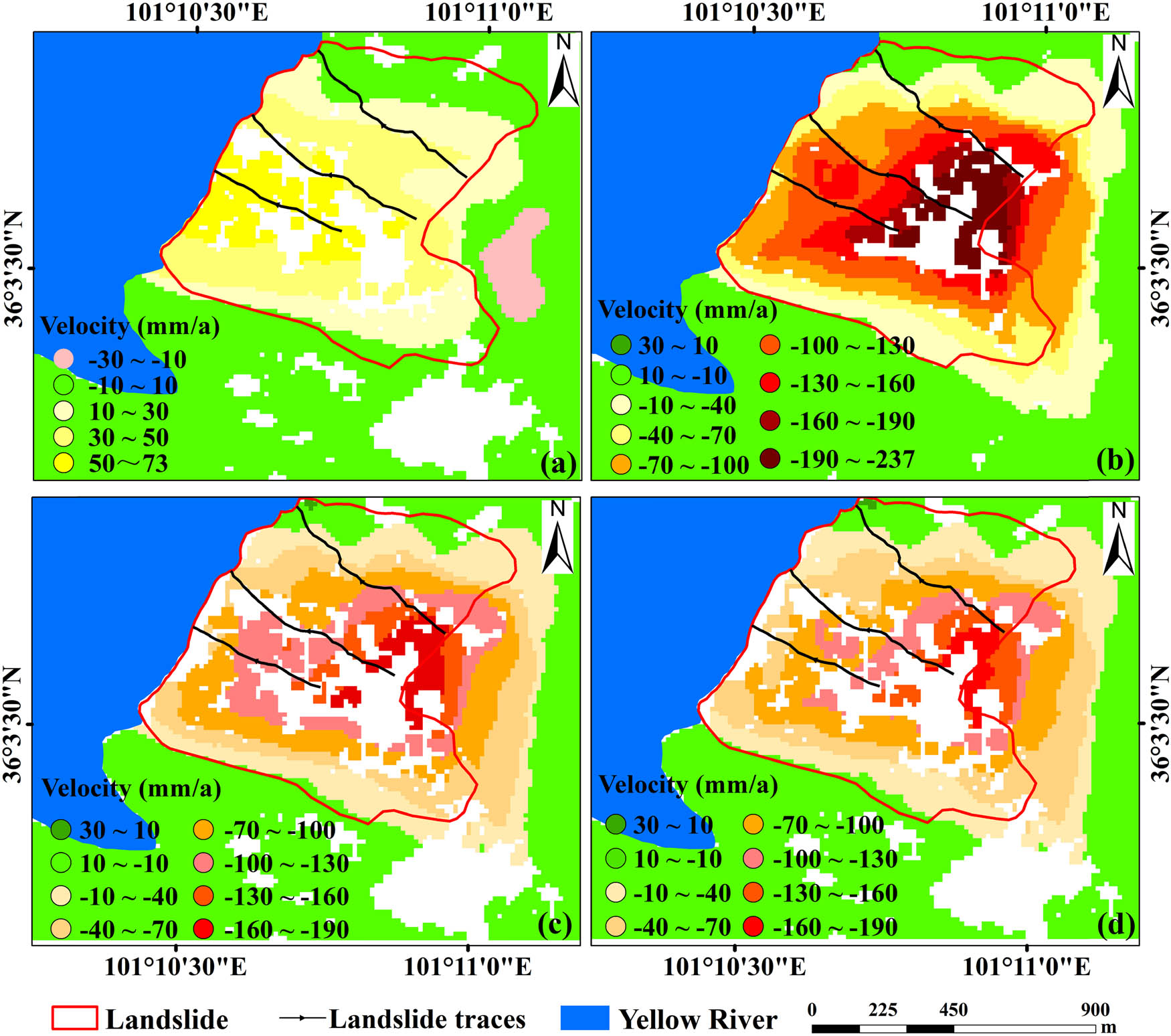
This study employed InSAR technology to jointly identify high deformation areas in both ascending and descending tracks and analyze their deformation characteristics and influencing factors. As the area is located in the Guobude region, Guinan County, Qinghai Province, China, it is known as the Guobude landslide in this study. Guobude landslide is situated on the right bank of the Yellow River, with a maximum slope width of about 950 m and a maximum elevation difference of about 523 m. The surrounding areas are relatively stable, with a local area in the eastern part showing a higher deformation rate, as shown in Figure 7. This part of the area exhibits a slope of less than 12.5°, with a relatively flat terrain. It has no significant impact on the formation of Guobude landslide deformation. Due to significant topographic variation between the top and bottom of the Guobude landslide, the annual deformation rate in the descending track direction is the highest at −237mm/a, while the annual deformation rate in the ascending track direction is the highest at 73 mm/a. Guobude landslide exhibits higher subsidence in both ascending and descending track directions. From the Google Earth image, it can be observed that the surface of the slide is predominantly loose rock and soil, while the slope foot at the bottom of the slide scar has accumulated fallen rock and soil. This suggests that the Guobude landslide has not yet resulted in large-scale sliding. Because the surface deformation rate measured by InSAR technology in both ascending and descending tracks revealed that the Guobude landslide was the area with the fastest subsidence, this study performed a detailed analysis of the causes behind, Guobude landslide deformation.
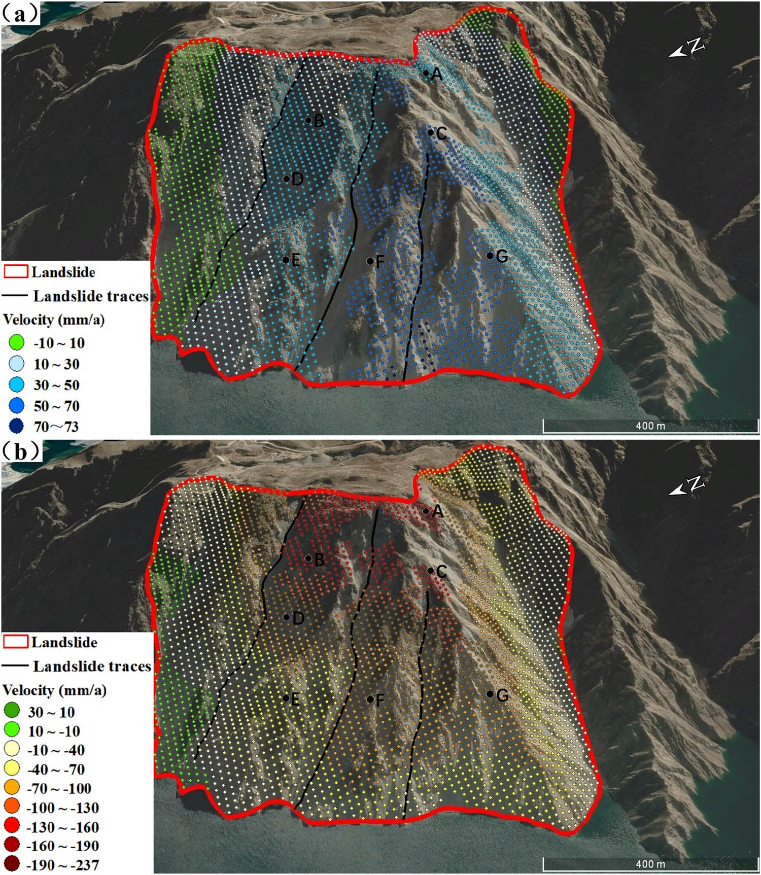
Figures 6(a)–(d) demonstrate the annual rate of deformation for the Guobude landslide in the ascending, descending, east–west, and vertical directions, respectively. From Figure 5(a), it can be observed that the annual rate of deformation in the ascending direction is −19.8 to 73 mm/a for the Guobude landslide. Figure 6(b) indicates that the annual rate of deformation in the descending direction is −237 to 17.5 mm/a. This is the largest value of surface deformation rate observed in this study area. Figure 6(c) illustrates the deformation rate field of the Guobude landslide in the east-west direction. The positive values indicate movement from west to east, while negative values indicate movement from east to west. The annual rate of deformation in the east–west direction for the Guobude landslide is −190.8 to 12.5 mm/a, following a general movement from east to west, which aligns with the direction of the landslide trace. Figure 6(d) indicates the annual rate of deformation in the vertical direction, with negative values representing downward movement. The Guobude landslide has an annual rate of deformation of −179.1 to 12.9 mm/a in the vertical direction, with the rate of deformation on the slope decreasing from the top of the slope toward the base of the slope, and the whole landslide exhibiting a rapid downhill trend.
Deformation velocity of the Guobude landslide: (a) annual deformation rate in the ascending LOS direction, (b) annual deformation rate in the descending LOS direction, (c) annual deformation rate in the east–west direction, and (d) annual deformation rate in the vertical direction.
3.3 Deformation characteristics of the Guobude landslide
Integrating the results of InSAR with Google Earth imagery can provide a better analysis of the actual displacement of the Guobude landslide. Overall, the Guobude landslide has a square shape with a steep slope on the slide surface, making it a typical example of slope failure. Three distinct sliding traces can be observed on the slide surface as a result of the long-term sliding of loose sandstone and broken rock. The sliding traces exhibit a V shape with respect to the sides of the slope, as shown in Figure 7. The proximity of the slide front to the Yellow River makes it susceptible to river erosion and water level fluctuations in the Yellow River, leading to the development of multiple gullies at the toe of the slope.
The annual average LOS deformation rate of the Guobude landslide: (a) ascending direction and (b) descending direction.
Figure 7(a) illustrates the annual average deformation rate of the Guobude landslide in the LOS direction. It can be observed that the stable sides of the landslide surface exhibit relatively low deformation rates of −10–10 mm/a. The central part of the landslide surface exhibits a higher deformation rate of 50 to 70 mm/a, and the bottom part has a deformation rate of up to 73 mm/a. As a result, the deformation rate decreases toward the left and right sides of the landslide surface. The central part of the structure likely protrudes, with a slope that is significantly greater than that on the sides and is influenced by factors such as self-weight and human engineering activities. Therefore, the central part exhibits a larger deformation rate.
Figure 7(b) illustrates the annual average deformation rate of the Guobude landslide in the LOS direction. It can be observed that except for the left and right sides and a small portion of the bottom area with lower deformation rates, the remaining area exhibits deformation rates greater than 40 mm/a. Low deformation rates are observed on both sides of the landslide in the ascending track direction, indicating that the sides are in a relatively stable stage. At the same time, the deformation rate in the middle of the landslide surface is significantly higher compared to the sides, with the top area exhibiting a deformation rate of −237 to −190 mm/a, indicating an extremely unstable area. In the ascending track LOS direction, the deformation rate increases from top to bottom sequentially, while in the descending track LOS direction, it decreases in the same manner. This opposite trend in the deformation rates may be due to the SAR satellite flying from south to north in the ascending track and north to south in the descending track.
3.4 Analysis of influencing factors of Guobude landslide deformation
The slope is one of the major factors contributing to landslides. As the slope increases, the influence of self-weight on the terrain also increases. Once the terrain reaches its limit of resistance to shear forces, cracks may form between the terrain and the structure. The external forces can accelerate the formation of cracks, and once the cracks reach a certain degree, they can cause the terrain to slide. The Guobude landslide has a steep geographical location, with the slope of the surface in most areas of the landslide ranging from 30° to 40°. The slope in only a small portion ranges from 20° to 30° and 42° to 52°. As shown in Figure 8, the maximum slope reaches 51.4°, providing good geographical conditions for the occurrence of landslides.
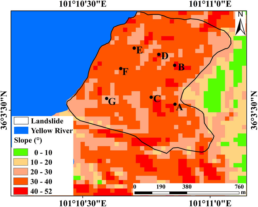
Detail of the slope of the Guobude landslide.
The Guobude landslide is situated in the hard rock area, with a good stratum lithology. However, the Google Earth images reveal that the surface of the Guobude landslide is predominantly sandstone, broken rock, weathered sand, etc., as shown in Figure 7. The accumulated sandstone and crushed rock exhibit poor resistance to external forces, leading to a significant threat to slope stability under the influence of human engineering activities, precipitation, and other factors. In this study, the three evident slippage marks on the slope of the Guobude landslide are formed by the long-term sliding of loose sandstone and broken rock.
The degree of vegetation development exhibits an inconsistent impact on the slope stability. Generally, the better the vegetation development, the better the slope stability. The vegetation index in the upper reaches of the Yellow River (i.e., from Gonghe to Xunhua) is about 0.2, indicating low vegetation coverage. The Google Earth images reveal that the surface of the Guobude landslide and its surrounding area is devoid of vegetation, as shown in Figure 7. With the loss of surface vegetation cover, the Guobude landslide is susceptible to erosion caused by rainwater. Excessive absorption results in the loosing and softening of soil, increasing its porosity. Additionally, the slope of most of the Guobude landslide area is greater than 30°, and the combined weight of the soil and rainwater significantly reduces the soil’s shear resistance capacity, thereby aggravating the formation of cracks and ultimately triggering landslides.
Integrating the surface deformation rate results obtained from the ascending and descending orbits of InSAR technology, seven areas with higher deformation rates at different elevations on the landslide surface were chosen as feature points, as shown in Figure 8. These areas were marked as A, B, C, D, E, F, and G. The relationship between the cumulative deformation of the Guobude landslide and precipitation from January 2021 to December 2023 was comprehensively analyzed by integrating the monthly cumulative precipitation from 2021 to 2023. As shown in Figure 9, the majority of precipitation in the Guobude landslide area in 2021 and 2022 was concentrated from June to September, while the majority of precipitation in 2023 was concentrated from May to September. It can be observed that the trends of change in cumulative deformation of feature points A, B, and D are inconsistent, while those of feature points C, E, F, and G are consistent. Throughout the InSAR monitoring period, feature points A, B, and D consistently showed an upward trend of cumulative deformation, with no significant change in cumulative deformation before and after periods of concentrated precipitation. Compared to feature points A, B, and D, the cumulative deformation trend of feature points C, E, F, and G is relatively slow. During periods of concentrated precipitation, all characteristic monitoring points showed no significant changes in deformation. Notably, the cumulative precipitation in August 2022 and May 2023 exceeded 100 mm, with slight deformation acceleration observed during subsequent months. When precipitation exceeds a certain threshold, it causes soil moisture saturation and augments gravitational loading on the slope material, thereby accelerating deformation. In conclusion, the monthly precipitation in the Guobude landslide area remains insufficient to substantially influence slope deformation, indicating no significant correlation between precipitation patterns and deformation dynamics.
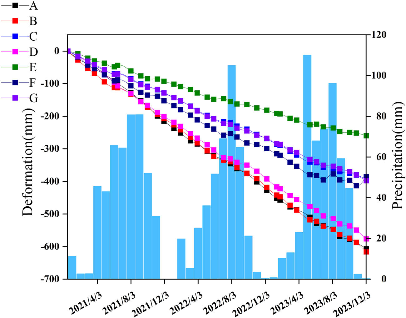
Time series displacement of characteristic points of Guobude landslide.
Based on the statistics, the accumulated deformation of each characteristic point on the Guobude landslide was monitored using the InSAR technology. The maximum subsidence of characteristic points A, B, C, D, E, F, and G is 606.6, 616.1, 391.7, 576.3, 259.9, 385.3, and 397.7 mm, respectively, as shown in Table 2. The slope of characteristic points A is approximately 37.8°, while that of characteristic points B and D is approximately 40.9. The slope of characteristic points C and E is approximately 31.4°, while that of F and G is approximately 30.6° and 25.7°, respectively, as shown in Figure 8. Based on the above analysis, the deformation results of the Guobude landslide are positively correlated with the slope, because as the slope increases, the influence of the ground surface objects on the slope also increases, with the lack of vegetation on the landslide surface resulting in greater deformation.
Slope stability of Guobude landslide
| Feature point | Slope (°) | Cumulative displacement (mm) | Slope stability |
|---|---|---|---|
| A | 37.8 | 606.6 | Extremely unstable |
| B | 40.9 | 616.1 | Extremely unstable |
| C | 31.4 | 391.7 | Unstable |
| D | 40.9 | 576.3 | Extremely unstable |
| E | 31.4 | 259.9 | Relatively stable |
| F | 30.6 | 385.3 | Unstable |
| G | 25.7 | 397.7 | Unstable |
Based on the above analysis, the primary factors influencing the deformation of the Guobude landslide are as follows: First, the surface geological strata of the Guobude landslide are sedimentary sandstone and broken rock, exhibiting poor mechanical properties. Second, the vegetation coverage on the surface of the Guobude landslide is relatively small, with no vegetation root system to stabilize the surface soil. Third, overall, the Guobude landslide has a large slope, with the sandstone and broken rock on the surface significantly influenced by their weight. The absence of vegetation further increases sliding. However, the concentrated precipitation did not accelerate the landslide deformation nor significantly influence its formation.
4 Discussion
4.1 Compare with previous studies
The potential landslides identified in this study are primarily distributed in the southeastern region of Longyang Gorge, the northern area of Lijia Gorge, Jianzha County, and Hualong County. A comparison of the findings of existing studies on landslide monitoring in the upper reaches of the Yellow River reveals that the spatial distributions of the landslides detected in this study are highly consistent with those reported in previous studies. For example, Du et al. utilized Stacking-InSAR technology to detect the distribution of landslides in the upper reaches of the Yellow River [21]. Zhao et al. determined the precise geographical locations of landslides in the same region by integrating SBAS-InSAR and optical remote sensing images [28]. The landslides identified in these two studies are primarily concentrated in the southeastern part of Longyang Gorge, the northern section of Lijia Gorge, Jianzha County, and Hualong County. In contrast, Li et al., using a superposition of remote sensing images and DEM, directly interpreted the landslide inventory in the upper reaches of the Yellow River by analyzing differences in tone, shape, shadow, texture, and pattern between landslides and the background in the remote sensing imagery. However, this approach resulted in the omission of most landslides in the southeastern region of Longyang Gorge [56], likely due to insufficient contrast between the landslides and the background, which led visual interpreters to overlook them. Consequently, this further underscores the importance of InSAR technology for large-scale identification and real-time monitoring of long-term landslide disasters, given its ability to achieve wide-range and millimeter-level deformation monitoring accuracy.
To elucidate the factors influencing landslide deformation, this study conducts a comprehensive analysis of the Guobude landslide from four perspectives: lithology, slope, vegetation coverage, and precipitation. Among these factors, lithology, slope, and vegetation coverage are potential factors that induce landslides, which aligns with the findings of prior studies. For example, Zhao et al. concluded through statistical analysis that landslides tend to occur in areas with weak rock properties. Low vegetation coverage accelerates the weathering of rock and soil masses. Coupled with the substantial diurnal temperature variations in the upper reaches of the Yellow River, thermal expansion and contraction contribute to the disintegration of rock and soil, leading to the fragmentation of slope materials and a consequent reduction in slope stability [28]. Tian et al. observed a direct correlation between landslide occurrence and slope gradient, noting that landslides occur more frequently and exhibit greater deformation on steeper slopes within a certain range [42].
Precipitation, as one of the critical environmental factors contributing to landslide instability, has consistently drawn significant attention because of its influence mechanism on landslide deformation. By analyzing temporal displacement and monthly cumulative precipitation, this study revealed no significant correlation between the deformation characteristics of the Guobude landslide and regional monthly precipitation. This finding is consistent with Tu et al.’s study on the Lijia Gorge landslide group in the adjacent area, where no significant correlation was observed between the temporal displacement of the landslide group and daily precipitation fluctuations [29]. Furthermore, the slope velocity remained stable before and after the concentrated precipitation season. In contrast, Tian et al. analyzed the relationship between typical landslide displacement in Hualong County and monthly precipitation, identifying a significant correlation between landslide movement and monthly precipitation, thereby confirming precipitation as the primary factor influencing landslide deformation [42]. The discrepancies in these research conclusions may be attributed to differences in the topographic gradient characteristics of the respective slopes. Statistical analysis indicates that the Guobude landslide develops on steep slopes ranging from 30° to 52°, whereas the landslide group in Hualong County is primarily distributed across gentler slopes ranging from 25° to 35°. This topographic variation has a significant impact on hydrological processes. When the slope gradient exceeds 30°, surface runoff rates increase substantially, reducing precipitation infiltration time. Consequently, the rock and soil masses do not reach water saturation, diminishing the influence of precipitation on landslide deformation.
4.2 Limitations and prospects
Due to the inherent side-view imaging geometry of SAR satellites, substantial geometric distortions may manifest in topographically complex mountainous regions, particularly exemplified in areas such as the upper Yellow River basin. To mitigate errors induced by geometric distortions, this study employs 30 m resolution SRTM DEM data to maximally suppress residual terrain phase artifacts. Furthermore, a synergistic analysis of ascending and descending orbital tracks is implemented to alleviate the shadowing and layover effects inherent to single-track observations. With respect to SBAS-InSAR processing, the configuration of spatiotemporal baseline thresholds critically governs the output accuracy. Excessively restrictive baseline criteria, while preserving high interferometric coherence, inevitably diminish the quantity of viable interferometric pairs, impair the temporal sampling density of deformation sequences, and increase parameter estimation uncertainties. Conversely, overly lenient spatiotemporal baseline thresholds degrade coherence levels and propagate phase unwrapping errors. Through iterative experimental validation, InSAR monitoring results were obtained with temporal baselines constrained to 90–120 days and spatial baselines limited to 120 m.
When the influence mechanism of precipitation on landslide deformation was investigated in this study, existing analytical methods were found to be limited by their global perspective. Notably, Ghaderpour et al. proposed the application of the STPD to landslide deformation monitoring. By comparing and analyzing the trend turning points between the landslide deformation time series displacement data obtained via PS-InSAR technology and the cumulative precipitation time series data constructed from global precipitation measurements and local precipitation data, a strong correlation was identified between the trend turning point times of the two datasets [15]. This methodological advancement has unique application value in the context of climate change, enables temporal correlation analysis between the landslide deformation process and precipitation triggers, and provides an innovative analytical framework for quantitatively analyzing the dynamic mechanism of rain-landslide.
In conclusion, in future research, multiple temporal InSAR methods can be combined to reduce the uncertainty caused by a single InSAR method. Moreover, the STPD proposed by Ghaderpour et al. can be used to study the relationship between precipitation and the changes in landslide deformation trends and analyze the influence of precipitation on landslide deformation from a global perspective. Furthermore, machine learning models can be used to integrate multisource datasets to analyze the factors influencing landslide displacement comprehensively.
5 Conclusions
This study was based on ascending and descending Sentinel-1A data and employed SBAS-InSAR technology to determine the surface deformation rate of the upper reaches of the Yellow River (i.e., from Gonghe to Xunhua). It also identified potential landslides using optical remote sensing imagery and examined the development characteristics and factors influencing the deformation of the Guobude landslide. The major conclusions drawn from this study are as follows:
Based on the surface deformation rate determined by the SBAS-InSAR technology in the ascending and descending tracks along the LOS direction, in combination with optical remote sensing images, a total of 171 potential landslide sites along the ascending track, 154 along the descending track, and 98 along both tracks were identified.
The detected potential landslides indicated that the distribution of potential landslides was strongly associated with the lithology of the rock strata. In the ascending direction, 8 potential landslides were identified on the strong stratum, 19 on hard rock, and the remaining 117 on softer and weaker rock strata. In the descending direction, 20 potential landslides were identified on strong stratum, 25 on hard rock, and the remaining 109 on softer and weaker rock strata.
During the monitoring period of InSAR technology, the Guobude landslide showed its highest subsidence rate. Located on the west bank of the Yellow River, overall, the landslide moves from east to west, directly threatening the safety of the Yellow River. The areas where the feature points A, B, and D were located experienced significant deformation, with cumulative deformation of 606.6, 616.1, and 576.3 mm, respectively. Other areas with more evident deformation experienced a cumulative deformation greater than 200 mm. The deformation of the Guobude landslide can be primarily attributed to the lack of vegetation in the area, and the overall slope greater than 20°, which makes it prone to gravity, leading to the accumulated sandstone and broken rock to slide. Precipitation had no significant influence on landslide deformation.
In this study, InSAR technology and optical remote sensing technology were integrated to detect and analyze potential landslides in the upper reaches of the Yellow River. The research results demonstrated high accuracy and reliability, and can offer a scientific basis for monitoring, risk assessment, and early warning of landslide disasters in the upper reaches of the Yellow River. It also holds significant value for the developing integrated real-time monitoring and early warning system of “air and earth” in the study area as well as optimizing governance measures. This is conducive to ensuring the ecological security and high-quality sustainable development of the Yellow River.
Acknowledgments
The Digital Elevation Model data were provided by the United States Geological Survey (USGS).
-
Funding information: This work was funded by Qinghai Institute of Technology “Kunlun Talent” Talent Introduction Research Project (2023-QLGKLYCZX-25).
-
Author contributions: The manuscript was reviewed and approved for publication by all authors. Jin Zeng and Wanbing Tuo conceived and designed the experiments. Jin Zeng performed the experiments, analyzed the data, drew the figures, and wrote the article. Wanbing Tuo revised the article. Xinchao Wang and Xingchang Zhao helped complete the experiment.
-
Conflict of interest: The authors declare no conflict of interest.
-
Data availability statement: The data supporting the findings of this study are available from the corresponding author upon reasonable request.
References
[1] Huang F, Xiong H, Yao C, Catani F, Zhou C, Huang J. Uncertainties of landslide susceptibility prediction considering different landslide types. J Rock Mech Geotech Eng. 2023;15(11):2954–72.10.1016/j.jrmge.2023.03.001Search in Google Scholar
[2] Wu H, Trigg MA, Murphy F, Fuentes R. Analysis of the fundamental differences between dam-forming landslides and all landslides. Geomorphology. 2025;475(15):109665.10.1016/j.geomorph.2025.109665Search in Google Scholar
[3] Gómez D, García EF, Aristizábal E. Spatial and temporal landslide distributions using global and open landslide databases. Nat Hazards. 2023;117:25–55.10.1007/s11069-023-05848-8Search in Google Scholar
[4] Zhang D, Zhang L, Dong J, Wang Y, Yang C, Liao M. Improved phase gradient stacking for landslide detection. Landslides. 2024;21:1829–47.10.1007/s10346-024-02263-3Search in Google Scholar
[5] Li Z, Yang M, Qiu H, Wang T, Ullah M, Yang D, et al. Spatiotemporal patterns of non-seismic fatal landslides in China from 2010 to 2022. Landslides. 2025;22:221–33.10.1007/s10346-024-02362-1Search in Google Scholar
[6] Franceschini R, Rosi A, Catani F, Casagli N. Exploring a landslide inventory created by automated web data mining: the case of Italy. Landslides. 2022;19:841–53.10.1007/s10346-021-01799-ySearch in Google Scholar
[7] Calvello M, Pecoraro G. FraneItalia: a catalog of recent Italian landslides. Geoenviron Disasters. 2018;5:13.10.1186/s40677-018-0105-5Search in Google Scholar
[8] Sana E, Kumar A, Robson E, Prasanna R, Kala U, Toll DG. Investigation of landslides triggered by unprecedented rainfall events during 2023 monsoon in Himachal Pradesh, India. Landslides. 2025;22:1529–50.10.1007/s10346-025-02471-5Search in Google Scholar
[9] Sharma M, Das S, Pain A, Kanungo DP, Sarkar S. Preliminary assessment of the Shiv Bawdi landslide in Shimla, Himachal Pradesh, India. Landslides. 2024;21:1591–601.10.1007/s10346-024-02234-8Search in Google Scholar
[10] Sharma KCR, Dahal K, Aryal BK, Subedi M. Study of the spatial distribution and the temporal trend of landslide disasters that occurred in the Nepal Himalayas from 2011 to 2020. Environ Earth Sci. 2024;83:42.10.1007/s12665-023-11347-7Search in Google Scholar
[11] He L, Zhou Y, Liu L, Zhang Y, Ma J. Application of the YOLOv11-seg algorithm for AI-based landslide detection and recognition. Sci Rep. 2025;15:12421.10.1038/s41598-025-95959-ySearch in Google Scholar PubMed PubMed Central
[12] Haque U, Silva PF, Devoli G, Pilz J, Zhao B, Khaloua A, et al. The human cost of global warming: Deadly landslides and their triggers (1995–2014). Sci Total Environ. 2019;682:673–84.10.1016/j.scitotenv.2019.03.415Search in Google Scholar PubMed
[13] Coluzzi R, Perrone A, Samela C, Imbrenda V, Manfreda S, Pace L, et al. Rapid landslide detection from free optical satellite imagery using a robust change detection technique. Sci Rep. 2025;15:4697.10.1038/s41598-025-89542-8Search in Google Scholar PubMed PubMed Central
[14] Ghaderpour E, Antonielli B, Bozzano F, Mugnozza GS, Mazzanti P. A fast and robust method for detecting trend turning points in InSAR displacement time series. Comput Geosci. 2024;185:105546.10.1016/j.cageo.2024.105546Search in Google Scholar
[15] Ghaderpour E, Masciulli C, Zocchi M, Bozzano F, Mugnozza GS, Mazzanti P. Estimating Reactivation times and velocities of slow-moving landslides via PS-InSAR and their relationship with precipitation in Central Italy. Remote Sens. 2024;16(16):3055.10.3390/rs16163055Search in Google Scholar
[16] Khan BA, Zhao C, Kakar N, Chen X. SBAS-InSAR monitoring of landslides and glaciers along the karakoram highway between China and Pakistan. Remote Sens. 2025;17(4):605.10.3390/rs17040605Search in Google Scholar
[17] Roy P, Martha TR, Mishra B, Majumdar R, Saha R, Das IC, et al. South Lhonak Lake Disaster in Sikkim, India: impact analysis using optical imagery, SBAS-InSAR and numerical simulation. J Indian Soc Remote Sens. 2025. Forthcoming. 10.1007/s12524-025-02192-1.Search in Google Scholar
[18] Guo X, Sun Z, Lai Z, Lu Y, Li X. Optical dating of landslide-dammed lake deposits in the upper Yellow River, Qinghai-Tibetan Plateau, China. Quat Int. 2016;392(21):233–8.10.1016/j.quaint.2015.06.021Search in Google Scholar
[19] Tian N, Lan H, Li L, Peng J, Fu B, Clague JJ. Human activities are intensifying the spatial variation of landslides in the Yellow River Basin. Sci Bull. 2025;70(2):263–72.10.1016/j.scib.2024.07.007Search in Google Scholar PubMed
[20] Zhao J, Huang Q, Peng J, Wang Z, Ma P, Leng Y, et al. Typical characteristics and causes of giant landslides in the upper reaches of the Yellow River, China. Landslides. 2024;22:313–34.10.1007/s10346-024-02363-0Search in Google Scholar
[21] Du J, Li Z, Song C, Zhu W, Ji Y, Zhang C. InSAR-based active landslide detection and characterization along the upper reaches of the yellow river. IEEE J-STARS. 2023;16:3819–30.10.1109/JSTARS.2023.3263003Search in Google Scholar
[22] Guo X, Wei J, Song Z, Lai Z, Yu L. Optically stimulated luminescence chronology and geomorphic imprint of Xiazangtan landslide upon the upper Yellow River valley on the northeastern Tibetan Plateau. Geol J. 2020;55(7):5498–507.10.1002/gj.3754Search in Google Scholar
[23] Yang X, Chen Y. Characteristics and mechanism of landslides on highway landfill along Xiaolangdi Reservoir of the Yellow River: a case study. Nat Hazards. 2024;120:10321–43.10.1007/s11069-024-06607-zSearch in Google Scholar
[24] He Y, Wang W, Zhang L, Chen Y, Chen Y, Chen B, et al. An identification method of potential landslide zones using InSAR data and landslide susceptibility. Geomat Nat Hazards Risk. 2023;14(1):2185120.10.1080/19475705.2023.2185120Search in Google Scholar
[25] Ma R, Yu H, Liu X, Yuan X, Geng T, Li P. InSAR-YOLOv8 for wide-area landslide detection in InSAR measurements. Sci Rep. 2025;15:1595. https://doi.org/10.1038/s41598-024-84626-3.Search in Google Scholar PubMed PubMed Central
[26] Xiong Z, Zhang M, Ma J, Xing G, Feng G, An Q. InSAR-based landslide detection method with the assistance of C-index. Landslides. 2023;20:2709–23.10.1007/s10346-023-02120-9Search in Google Scholar
[27] Zhu Z, Yuan X, Gan S, Zhang J, Zhang X. A research on a new mapping method for landslide susceptibility based on SBAS-InSAR technology. Egypt J Remote Sens Space Sci. 2023;26(4):1046–56.10.1016/j.ejrs.2023.11.009Search in Google Scholar
[28] Zhao S, Zeng R, Zhang Z. Early identification and influencing factors of potential landsli-des in the upper reaches of the Yellow River. J Mt Sci. 2022;40(02):249–64.Search in Google Scholar
[29] Tu K, Ye S, Zou J, Hua C, Guo J. InSAR displacement with high-resolution optical remote sensing for the early detection and deformation analysis of active landslides in the upper yellow river. Water. 2023;15(4):769.10.3390/w15040769Search in Google Scholar
[30] Zhu Q. Research on landslide hidden danger identification and deformation monitoring based on InSAR technology. Beijing: China University of Geosciences; 2021.Search in Google Scholar
[31] Fei X, Tian Y, Zhao C. Identification and deformation monitoring of unstable slope in Longyangxia Reservoir area of upper Yellow River based on multi-temporal InSAR technology. J Earth Sci Environ. 2023;45(03):578–89.Search in Google Scholar
[32] Yue L, Liu C, Cong X. Monitoring and analysis of surface deformation in Xiazangtan landslide area based on InSAR technology. Hydrogeol Eng Geol. 2024;51(03):158–70.Search in Google Scholar
[33] Guo X, Wei J, Lu Y, Song Z, Liu H. Geomorphic effects of a dammed pleistocene lake formed by landslides along the upper yellow river. Water. 2020;12(5):1350.10.3390/w12051350Search in Google Scholar
[34] Zhang Z, Zeng R, Zhao S, Meng X, Ma J, Yin H, et al. Effects of irrigation projects on the classification of yellow river terrace landslides and their failure modes: a case study of heitai terrace. Remote Sens. 2023;15(20):5012.10.3390/rs15205012Search in Google Scholar
[35] Wang Z, Sun Y, Jia Y, Shan Z, Shan H, Zhang S, et al. Wave-induced seafloor instabilities in the subaqueous Yellow River Delta—initiation and process of sediment failure. Landslides. 2020;17:1849–62.10.1007/s10346-020-01399-2Search in Google Scholar
[36] Guo P, Meng X, Li Y, Chen G, Zeng R, Qiao L. Effect of large dams and irrigation in the upper reaches of the Yellow River of China, and the geohazards burden. Proc Geol Assoc. 2015;126(3):367–76.10.1016/j.pgeola.2015.03.009Search in Google Scholar
[37] Lan H, Peng J, Zhu Y, Li L, Pan B, Huang Q, et al. Research on geological and surfacial processes and major disaster effects in the Yellow River Basin. Sci China Earth Sci. 2021;65:234–56.10.1007/s11430-021-9830-8Search in Google Scholar
[38] Guo X, Forman S, Marin L, Li X. Assessing tectonic and climatic controls for Late Quaternary fluvial terraces in Guide, Jianzha, and Xunhua Basins along the Yellow River on the northeastern Tibetan Plateau. Quat Sci Rev. 2018;195:109–21.10.1016/j.quascirev.2018.07.005Search in Google Scholar
[39] Wu X, Qi X, Peng B, Wang J. Optimized landslide susceptibility mapping and modelling using the SBAS-InSAR coupling model. Remote Sens. 2024;16(16):2873.10.3390/rs16162873Search in Google Scholar
[40] Zhu Z, Gan S, Yuan X, Zhang J. Landslide susceptibility mapping with integrated SBAS-InSAR technique: a case study of Dongchuan District, Yunnan (China). Sensors. 2022;22(15):5587.10.3390/s22155587Search in Google Scholar PubMed PubMed Central
[41] Zhao F, Meng X, Zhang Y, Chen G, Su X, Yue D. Landslide susceptibility mapping of karakorum highway combined with the application of SBAS-InSAR technology. Sensors. 2019;19(12):2685.10.3390/s19122685Search in Google Scholar PubMed PubMed Central
[42] Tian H, Kou P, Xu Q, Tao Y, Jin Z, Xia Y, et al. Analysis of landslide deformation in eastern Qinghai Province, Northwest China, using SBAS-InSAR. Nat Hazards. 2024;120:5763–84.10.1007/s11069-024-06442-2Search in Google Scholar
[43] Yang S, Li D, Liu Y, Xu Z, Sun Y, She X. Landslide identification in human-modified alpine and Canyon Area of the Niulan River basin based on SBAS-InSAR and optical images. Remote Sens. 2023;15(8):1998.10.3390/rs15081998Search in Google Scholar
[44] Dong J, Niu R, Li B, Xu H, Wang S. Potential landslides identification based on temporal and spatial filtering of SBAS-InSAR results. Geomat Nat Hazards. Risk. 2022;14(1):52–75.10.1080/19475705.2022.2154574Search in Google Scholar
[45] Ran P, Li S, Zhuo G, Wang X, Meng M, Liu L, et al. Early identification and influencing factors analysis of active landslides in mountainous areas of Southwest China using SBAS−InSAR. Sustainability. 2023;15(5):4366.10.3390/su15054366Search in Google Scholar
[46] Cui J, Tao Y, Kou P, Jin Z, Huang Y, Zhang J. Hydrological influences on landslide dynamics in the three gorges reservoir area: an SBAS-InSAR study in Yunyang county, Chongqing. Environ Earth Sci. 2024;83:466.10.1007/s12665-024-11770-4Search in Google Scholar
[47] Li Y, Ji P, Liu S, Zhao J, Yang Y. Susceptibility evaluation of highway landslide disasters based on SBAS-InSAR: a case study of S211 highway in Lanping County. Nat Hazards. 2025;121:2587–612.10.1007/s11069-024-06807-7Search in Google Scholar
[48] Liu M, Xu B, Li Z, Mao W, Zhu Y, Hou J, et al. Landslide susceptibility Zoning in Yunnan Province Based on SBAS-InSAR technology and a random forest model. Remote Sens. 2023;15(11):2864.10.3390/rs15112864Search in Google Scholar
[49] Bian S, Chen G, Zeng R, Meng X, Jin J, Lin L, et al. Post-failure evolution analysis of an irrigation-induced loess landslide using multiple remote sensing approaches integrated with time-lapse ERT imaging: lessons from Heifangtai, China. Landslides. 2022;19:1179–97.10.1007/s10346-022-01859-xSearch in Google Scholar
[50] Tao Q, Liu R, Li X, Gao T, Chen Y, Xiao Y, et al. A method for monitoring three dimensional surface deformation in mining areas combining SBAS-InSAR, GNSS and probability integral method. Sci Rep. 2025;15:2853.10.1038/s41598-025-87087-4Search in Google Scholar PubMed PubMed Central
[51] Jia H, Wang Y, Ge D, Deng Y, Wang R. InSAR study of landslides: early detection, three-dimensional, and long-term surface displacement estimation—a case of Xiaojiang River Basin, China. Remote Sens. 2022;14(7):1759.10.3390/rs14071759Search in Google Scholar
[52] Li J, Xing X, Ou J. Locating and characterizing potential precipitation-induced landslides on a regional scale based on SBAS-InSAR technique. Bull Eng Geol Environ. 2023;82:329.10.1007/s10064-023-03356-4Search in Google Scholar
[53] Yao J, Yao X, Liu X. Landslide detection and mapping based on SBAS-InSAR and PS-InSAR: A Case Study in Gongjue County, Tibet, China. Remote Sens. 2022;14(19):4728.10.3390/rs14194728Search in Google Scholar
[54] Zhao C, Kang Y, Lu Z, Li B. Landslide identification and monitoring along the jinsha river catchment (Wudongde reservoir area), China, using the InSAR Method. Remote Sens. 2018;10(7):993.10.3390/rs10070993Search in Google Scholar
[55] Hu B, Li Z. Time-series InSAR technology for ascending and descending orbital images to monitor surface deformation of the metro network in Chengdu. IEEE J Sel Top Appl Earth Obs Remote Sens. 2021;14:12583–97.10.1109/JSTARS.2021.3130584Search in Google Scholar
[56] Li Z, Wei S, Wu K, Sha Y, Zhang X, Li D, et al. Study on temporal and spatial distribution of landslides in the upper reaches of the yellow river. Appl Sci. 2024;14(13):5488.10.3390/app14135488Search in Google Scholar
© 2025 the author(s), published by De Gruyter
This work is licensed under the Creative Commons Attribution 4.0 International License.
Articles in the same Issue
- Research Articles
- Seismic response and damage model analysis of rocky slopes with weak interlayers
- Multi-scenario simulation and eco-environmental effect analysis of “Production–Living–Ecological space” based on PLUS model: A case study of Anyang City
- Remote sensing estimation of chlorophyll content in rape leaves in Weibei dryland region of China
- GIS-based frequency ratio and Shannon entropy modeling for landslide susceptibility mapping: A case study in Kundah Taluk, Nilgiris District, India
- Natural gas origin and accumulation of the Changxing–Feixianguan Formation in the Puguang area, China
- Spatial variations of shear-wave velocity anomaly derived from Love wave ambient noise seismic tomography along Lembang Fault (West Java, Indonesia)
- Evaluation of cumulative rainfall and rainfall event–duration threshold based on triggering and non-triggering rainfalls: Northern Thailand case
- Pixel and region-oriented classification of Sentinel-2 imagery to assess LULC dynamics and their climate impact in Nowshera, Pakistan
- The use of radar-optical remote sensing data and geographic information system–analytical hierarchy process–multicriteria decision analysis techniques for revealing groundwater recharge prospective zones in arid-semi arid lands
- Effect of pore throats on the reservoir quality of tight sandstone: A case study of the Yanchang Formation in the Zhidan area, Ordos Basin
- Hydroelectric simulation of the phreatic water response of mining cracked soil based on microbial solidification
- Spatial-temporal evolution of habitat quality in tropical monsoon climate region based on “pattern–process–quality” – a case study of Cambodia
- Early Permian to Middle Triassic Formation petroleum potentials of Sydney Basin, Australia: A geochemical analysis
- Micro-mechanism analysis of Zhongchuan loess liquefaction disaster induced by Jishishan M6.2 earthquake in 2023
- Prediction method of S-wave velocities in tight sandstone reservoirs – a case study of CO2 geological storage area in Ordos Basin
- Ecological restoration in valley area of semiarid region damaged by shallow buried coal seam mining
- Hydrocarbon-generating characteristics of Xujiahe coal-bearing source rocks in the continuous sedimentary environment of the Southwest Sichuan
- Hazard analysis of future surface displacements on active faults based on the recurrence interval of strong earthquakes
- Structural characterization of the Zalm district, West Saudi Arabia, using aeromagnetic data: An approach for gold mineral exploration
- Research on the variation in the Shields curve of silt initiation
- Reuse of agricultural drainage water and wastewater for crop irrigation in southeastern Algeria
- Assessing the effectiveness of utilizing low-cost inertial measurement unit sensors for producing as-built plans
- Analysis of the formation process of a natural fertilizer in the loess area
- Machine learning methods for landslide mapping studies: A comparative study of SVM and RF algorithms in the Oued Aoulai watershed (Morocco)
- Chemical dissolution and the source of salt efflorescence in weathering of sandstone cultural relics
- Molecular simulation of methane adsorption capacity in transitional shale – a case study of Longtan Formation shale in Southern Sichuan Basin, SW China
- Evolution characteristics of extreme maximum temperature events in Central China and adaptation strategies under different future warming scenarios
- Estimating Bowen ratio in local environment based on satellite imagery
- 3D fusion modeling of multi-scale geological structures based on subdivision-NURBS surfaces and stratigraphic sequence formalization
- Comparative analysis of machine learning algorithms in Google Earth Engine for urban land use dynamics in rapidly urbanizing South Asian cities
- Study on the mechanism of plant root influence on soil properties in expansive soil areas
- Simulation of seismic hazard parameters and earthquakes source mechanisms along the Red Sea rift, western Saudi Arabia
- Tectonics vs sedimentation in foredeep basins: A tale from the Oligo-Miocene Monte Falterona Formation (Northern Apennines, Italy)
- Investigation of landslide areas in Tokat-Almus road between Bakımlı-Almus by the PS-InSAR method (Türkiye)
- Predicting coastal variations in non-storm conditions with machine learning
- Cross-dimensional adaptivity research on a 3D earth observation data cube model
- Geochronology and geochemistry of late Paleozoic volcanic rocks in eastern Inner Mongolia and their geological significance
- Spatial and temporal evolution of land use and habitat quality in arid regions – a case of Northwest China
- Ground-penetrating radar imaging of subsurface karst features controlling water leakage across Wadi Namar dam, south Riyadh, Saudi Arabia
- Rayleigh wave dispersion inversion via modified sine cosine algorithm: Application to Hangzhou, China passive surface wave data
- Fractal insights into permeability control by pore structure in tight sandstone reservoirs, Heshui area, Ordos Basin
- Debris flow hazard characteristic and mitigation in Yusitong Gully, Hengduan Mountainous Region
- Research on community characteristics of vegetation restoration in hilly power engineering based on multi temporal remote sensing technology
- Identification of radial drainage networks based on topographic and geometric features
- Trace elements and melt inclusion in zircon within the Qunji porphyry Cu deposit: Application to the metallogenic potential of the reduced magma-hydrothermal system
- Pore, fracture characteristics and diagenetic evolution of medium-maturity marine shales from the Silurian Longmaxi Formation, NE Sichuan Basin, China
- Study of the earthquakes source parameters, site response, and path attenuation using P and S-waves spectral inversion, Aswan region, south Egypt
- Source of contamination and assessment of potential health risks of potentially toxic metal(loid)s in agricultural soil from Al Lith, Saudi Arabia
- Regional spatiotemporal evolution and influencing factors of rural construction areas in the Nanxi River Basin via GIS
- An efficient network for object detection in scale-imbalanced remote sensing images
- Effect of microscopic pore–throat structure heterogeneity on waterflooding seepage characteristics of tight sandstone reservoirs
- Environmental health risk assessment of Zn, Cd, Pb, Fe, and Co in coastal sediments of the southeastern Gulf of Aqaba
- A modified Hoek–Brown model considering softening effects and its applications
- Evaluation of engineering properties of soil for sustainable urban development
- The spatio-temporal characteristics and influencing factors of sustainable development in China’s provincial areas
- Application of a mixed additive and multiplicative random error model to generate DTM products from LiDAR data
- Gold vein mineralogy and oxygen isotopes of Wadi Abu Khusheiba, Jordan
- Prediction of surface deformation time series in closed mines based on LSTM and optimization algorithms
- 2D–3D Geological features collaborative identification of surrounding rock structural planes in hydraulic adit based on OC-AINet
- Spatiotemporal patterns and drivers of Chl-a in Chinese lakes between 1986 and 2023
- Land use classification through fusion of remote sensing images and multi-source data
- Nexus between renewable energy, technological innovation, and carbon dioxide emissions in Saudi Arabia
- Analysis of the spillover effects of green organic transformation on sustainable development in ethnic regions’ agriculture and animal husbandry
- Factors impacting spatial distribution of black and odorous water bodies in Hebei
- Large-scale shaking table tests on the liquefaction and deformation responses of an ultra-deep overburden
- Impacts of climate change and sea-level rise on the coastal geological environment of Quang Nam province, Vietnam
- Reservoir characterization and exploration potential of shale reservoir near denudation area: A case study of Ordovician–Silurian marine shale, China
- Seismic prediction of Permian volcanic rock reservoirs in Southwest Sichuan Basin
- Application of CBERS-04 IRS data to land surface temperature inversion: A case study based on Minqin arid area
- Geological characteristics and prospecting direction of Sanjiaoding gold mine in Saishiteng area
- Research on the deformation prediction model of surrounding rock based on SSA-VMD-GRU
- Geochronology, geochemical characteristics, and tectonic significance of the granites, Menghewula, Southern Great Xing’an range
- Hazard classification of active faults in Yunnan base on probabilistic seismic hazard assessment
- Characteristics analysis of hydrate reservoirs with different geological structures developed by vertical well depressurization
- Estimating the travel distance of channelized rock avalanches using genetic programming method
- Landscape preferences of hikers in Three Parallel Rivers Region and its adjacent regions by content analysis of user-generated photography
- New age constraints of the LGM onset in the Bohemian Forest – Central Europe
- Characteristics of geological evolution based on the multifractal singularity theory: A case study of Heyu granite and Mesozoic tectonics
- Soil water content and longitudinal microbiota distribution in disturbed areas of tower foundations of power transmission and transformation projects
- Oil accumulation process of the Kongdian reservoir in the deep subsag zone of the Cangdong Sag, Bohai Bay Basin, China
- Investigation of velocity profile in rock–ice avalanche by particle image velocimetry measurement
- Optimizing 3D seismic survey geometries using ray tracing and illumination modeling: A case study from Penobscot field
- Sedimentology of the Phra That and Pha Daeng Formations: A preliminary evaluation of geological CO2 storage potential in the Lampang Basin, Thailand
- Improved classification algorithm for hyperspectral remote sensing images based on the hybrid spectral network model
- Map analysis of soil erodibility rates and gully erosion sites in Anambra State, South Eastern Nigeria
- Identification and driving mechanism of land use conflict in China’s South-North transition zone: A case study of Huaihe River Basin
- Evaluation of the impact of land-use change on earthquake risk distribution in different periods: An empirical analysis from Sichuan Province
- A test site case study on the long-term behavior of geotextile tubes
- An experimental investigation into carbon dioxide flooding and rock dissolution in low-permeability reservoirs of the South China Sea
- Detection and semi-quantitative analysis of naphthenic acids in coal and gangue from mining areas in China
- Comparative effects of olivine and sand on KOH-treated clayey soil
- YOLO-MC: An algorithm for early forest fire recognition based on drone image
- Earthquake building damage classification based on full suite of Sentinel-1 features
- Potential landslide detection and influencing factors analysis in the upper Yellow River based on SBAS-InSAR technology
- Assessing green area changes in Najran City, Saudi Arabia (2013–2022) using hybrid deep learning techniques
- An advanced approach integrating methods to estimate hydraulic conductivity of different soil types supported by a machine learning model
- Hybrid methods for land use and land cover classification using remote sensing and combined spectral feature extraction: A case study of Najran City, KSA
- Streamlining digital elevation model construction from historical aerial photographs: The impact of reference elevation data on spatial accuracy
- Analysis of urban expansion patterns in the Yangtze River Delta based on the fusion impervious surfaces dataset
- A metaverse-based visual analysis approach for 3D reservoir models
- Late Quaternary record of 100 ka depositional cycles on the Larache shelf (NW Morocco)
- Integrated well-seismic analysis of sedimentary facies distribution: A case study from the Mesoproterozoic, Ordos Basin, China
- Study on the spatial equilibrium of cultural and tourism resources in Macao, China
- Urban road surface condition detecting and integrating based on the mobile sensing framework with multi-modal sensors
- Application of improved sine cosine algorithm with chaotic mapping and novel updating methods for joint inversion of resistivity and surface wave data
- The synergistic use of AHP and GIS to assess factors driving forest fire potential in a peat swamp forest in Thailand
- Dynamic response analysis and comprehensive evaluation of cement-improved aeolian sand roadbed
- Rock control on evolution of Khorat Cuesta, Khorat UNESCO Geopark, Northeastern Thailand
- Gradient response mechanism of carbon storage: Spatiotemporal analysis of economic-ecological dimensions based on hybrid machine learning
- Comparison of several seismic active earth pressure calculation methods for retaining structures
- Mantle dynamics and petrogenesis of Gomer basalts in the Northwestern Ethiopia: A geochemical perspective
- Study on ground deformation monitoring in Xiong’an New Area from 2021 to 2023 based on DS-InSAR
- Paleoenvironmental characteristics of continental shale and its significance to organic matter enrichment: Taking the fifth member of Xujiahe Formation in Tianfu area of Sichuan Basin as an example
- Equipping the integral approach with generalized least squares to reconstruct relict channel profile and its usage in the Shanxi Rift, northern China
- InSAR-driven landslide hazard assessment along highways in hilly regions: A case-based validation approach
- Attribution analysis of multi-temporal scale surface streamflow changes in the Ganjiang River based on a multi-temporal Budyko framework
- Review Articles
- Humic substances influence on the distribution of dissolved iron in seawater: A review of electrochemical methods and other techniques
- Applications of physics-informed neural networks in geosciences: From basic seismology to comprehensive environmental studies
- Ore-controlling structures of granite-related uranium deposits in South China: A review
- Shallow geological structure features in Balikpapan Bay East Kalimantan Province – Indonesia
- A review on the tectonic affinity of microcontinents and evolution of the Proto-Tethys Ocean in Northeastern Tibet
- Special Issue: Natural Resources and Environmental Risks: Towards a Sustainable Future - Part II
- Depopulation in the Visok micro-region: Toward demographic and economic revitalization
- Special Issue: Geospatial and Environmental Dynamics - Part II
- Advancing urban sustainability: Applying GIS technologies to assess SDG indicators – a case study of Podgorica (Montenegro)
- Spatiotemporal and trend analysis of common cancers in men in Central Serbia (1999–2021)
- Minerals for the green agenda, implications, stalemates, and alternatives
- Spatiotemporal water quality analysis of Vrana Lake, Croatia
- Functional transformation of settlements in coal exploitation zones: A case study of the municipality of Stanari in Republic of Srpska (Bosnia and Herzegovina)
- Hypertension in AP Vojvodina (Northern Serbia): A spatio-temporal analysis of patients at the Institute for Cardiovascular Diseases of Vojvodina
- Regional patterns in cause-specific mortality in Montenegro, 1991–2019
- Spatio-temporal analysis of flood events using GIS and remote sensing-based approach in the Ukrina River Basin, Bosnia and Herzegovina
- Flash flood susceptibility mapping using LiDAR-Derived DEM and machine learning algorithms: Ljuboviđa case study, Serbia
- Geocultural heritage as a basis for geotourism development: Banjska Monastery, Zvečan (Serbia)
- Assessment of groundwater potential zones using GIS and AHP techniques – A case study of the zone of influence of Kolubara Mining Basin
- Impact of the agri-geographical transformation of rural settlements on the geospatial dynamics of soil erosion intensity in municipalities of Central Serbia
- Where faith meets geomorphology: The cultural and religious significance of geodiversity explored through geospatial technologies
- Applications of local climate zone classification in European cities: A review of in situ and mobile monitoring methods in urban climate studies
- Complex multivariate water quality impact assessment on Krivaja River
- Ionization hotspots near waterfalls in Eastern Serbia’s Stara Planina Mountain
- Shift in landscape use strategies during the transition from the Bronze age to Iron age in Northwest Serbia
- Assessing the geotourism potential of glacial lakes in Plav, Montenegro: A multi-criteria assessment by using the M-GAM model