
Examining the evacuation routes of the sister village program by using the ant colony optimization algorithm
-
Aziz Muhammad
 und
Taixia Wu
und
Taixia Wu

Abstract
Evacuation routes are necessary to guide people to avoid hazardous and dangerous zones and to prevent the loss of human lives, especially in the event of volcanic eruptions. This article attempts to examine the evacuation routes of the sister village program by using the ant colony optimization (ACO) algorithm. Model simulations and calculations of the ACO algorithm were done by aggregation of the five determined parameters including distance, speed, hurdle, density, and secure point. The validation of the model was carried out by the examination of the five most prone disaster villages located in Mount Merapi that are interconnected as sister villages in Sleman Regency, Yogyakarta Province, and Indonesia. This research is important to ensure that the sister village evacuation system is effective in reducing the impact of the risks posed by the eruption of Mount Merapi. Based on the results, sister village evacuation systems are proven to be the fastest and safest routes by the ACO examination
1 Introduction
Indonesia sits along what is known as the “Pacific Ring of Fire” where the majority of earth’s volcanoes and earthquakes take place. Several super-volcanic eruptions such as Mount Tambora in Sumbawa (1815) and Krakatoa (1883) were felt around the world [1,2]. On Java Island, Mount Merapi with a summit elevation of 2,968 m has been active for roughly 10,000 years. According to the Ministry of Energy and Mineral Resources, Mount Merapi ranks second among the most active volcanoes in Indonesia. Mount Merapi has erupted more than 80 times since 1768 [3,4,5]. Located on the border between Central Java and Yogyakarta Province, this region is particularly sensitive due to the high population density [6]. The International Association of Volcanology and Chemistry of the Earth's Interior named Merapi the Volcano of the Decade in 1995 because of its high volcanic activity [7]. Volcanic eruptions have an impact on people’s socio-economic conditions and cause losses and damages in housing and public infrastructure [8,9,10,11,12]. One of the most powerful eruptions occurred in 2010, which was acknowledged as the strongest one in the last 80 years. The explosion had a severe impact, in particular, on surrounding communities, especially those found on the southern flank [3,13,14,15,16,17].
Since that time, mitigation efforts to reduce the impacts of the eruptions have been developed including the creation of emergency procedures, evacuation routes, and infrastructure. It is obvious that evacuation measures are critical to saving lives in emergency situations. Evacuation is an intentional process designed to move communities from hazardous areas to safer places where the risk can be avoided [10,18]. Evacuation procedures need to take into consideration destination places based on certain criteria including safety and reachability. Establishing routes with large capacity and reducing major obstacles on the path is important in developing an evacuation traffic management strategy so that the existing routes’ capacity can be used to the fullest [10]. The evacuation routes are necessary to guide people to avoid hazardous and dangerous zones and to prevent the loss of human lives, especially in the event of an emergency [19,20,21]. Evacuation routes are made to normalize the situation and prevent and minimize injuries or deaths. Disaster experts, scientists, and humanitarian activists around the world are aware of the importance of evacuation routes in assisting affected communities quickly and safely in the event of a disaster. The search for the closest, fastest, and safest route for evacuation is one of the most urgent needs of communities that live in disaster-prone areas. To optimize the search for the most effective routes, a number of algorithms have been developed including the ACO algorithm, which was adopted from the behavioral system used by the ant colony [22,23,24,25].
Evacuation route analysis has been carried out by several researchers. Hardiansyah et al. [26] attempted to develop an evacuation model for the road network in KRB 1, 2, and 3 areas and in surrounding districts’ road networks. This analysis aims to see the increase in current traffic that occurs during the eruption. The result is that a vulnerable road network is only identified in KRB 1–3 areas, while it is proven by a negative index in its surrounding areas. In addition, in the KRB 1 – road networks where the vulnerability index is high [26], more serious attention is required from policymakers in preparing evacuation routes [27]. The authors also propose the development of a system-optimal model to provide better results for evacuation routes.
A literature review was conducted by Sopha et al. [28] to find the attributes that can affect the community in making evacuation decisions during the eruption of Mount Merapi. According to them, the behavioral factors of the people who live on the slopes of Mount Merapi have a very important influence in preparing an evacuation plan for Mount Merapi [29]. This study describes the behavior of evacuees during evacuation in the form of a rule of decision in choosing actions, adaptability, ability to learn from experience, and ability to perceive experience. It is highly possible that the behavior of each individual is different even though they are in the same family. This difference can be caused by risk perception, evacuation decisions and preparations, route determination, and awareness. These different behaviors will form a collective behavior, which is referred to as an emerging communal phenomenon. However, this study does not examine the existing communal agreements or what is known as the sister village.
A study on sister villages was conducted by Elysia and Wihadanto [8], which aims to explain the role of the sister village program in encouraging community resilience after the Merapi eruption. It was found that the sister village program system can fulfill many aspects of the community resilience component. In general, this study only describes the sister village program that includes community preparedness in dealing with disasters, post-disaster recovery at the local level, evacuation route plans, shelter, provision of food and other daily needs, and long-term economic recovery. However, this study did not mathematically test how the sister village route is considered effective in evacuating when an eruption occurs.
Through surveys and focus group discussions, Margono et al. [30] evaluated the preparedness of the sister village in the buffer village aspect. The aspects referred to the management of barracks, logistical readiness and capacity for evacuees, and capacity of the buffer villages to accommodate vulnerable groups: the elderly, children, pregnant women, breastfeeding mothers, and groups with disabilities. In addition, Margono et al. also discovered how barracks and logistical management have improved in terms of transparency and accountability. On the post-disaster recovery side, the authors also identified how educational provision is being implemented adequately. Furthermore, the authors suggested the need for capacity improvement in the economic recovery program provided by the buffer villages. Nevertheless, similar to the other previous studies, the study on the sister villages in terms of evacuation routes has never been discussed sufficiently.
With the lack of exploration on the sister village evacuation routes, this article aims to identify the best evacuation route for the sister village using ACO in determining the fastest and safest evacuation route in Mount Merapi. This research also examines whether the sister village pathway agreed among villages can be confirmed by ACO estimation results. It is expected that this study will benefit the mitigation and community evacuation plans supported by the government and local, national, and international humanitarian organizations. This article provides an alternative approach to find the best evacuation routes through an agent-based model of evacuation.
2 Materials and methods
2.1 Study area and data
Mount Merapi is located in four administrative districts: Magelang, Klaten, Boyolali, and Sleman with a total population of 4,855,299 [31]. In detail, the population of each district is as follows: the population of Magelang district is 1,290,591, the population of Klaten district is 1,174,986, the population of Boyolali district is 984,807, and the population of Sleman district is 1,282,804 [32]. The 2010 Mount Merapi eruption that occurred in October and November was the largest volcanic eruption in the last 80 years [31]. Small eruptions often occur in a cycle of approximately every 4–6 years. The 2010 Merapi volcanic eruption produced such a strong explosion that it was heard up to the southern part of Yogyakarta province with an eruption column height reaching 17 km and the pyroclastic flows followed the river channel up to 16 km away from the summit [15]. The 2010 Merapi evacuation displaced almost 400,000 people living within 20 km from the summit for 1.5 months [33]. Approximately, 277 lives in Yogyakarta and 109 lives in Central Java (RFCS, 2014) were lost and 150,000 buildings were destroyed, resulting in an estimated loss of more than USD 300 million [34] (Figure 1).
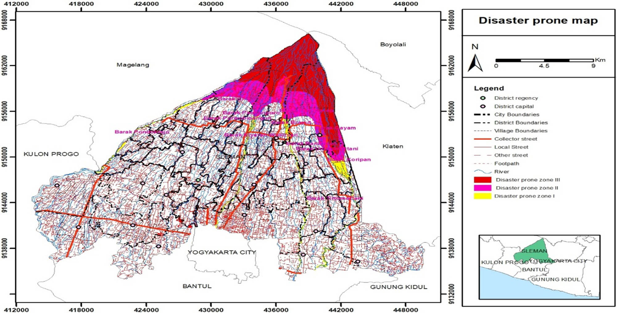
Map of the study area.
Based on the historical data, the first eruption occurred on October 26, followed by the second eruption on October 30, which resulted in pyroclastic flow (hot clouds) and volcanic ashfall. In response to this disastrous event, the Center for Volcanology and Geological Disaster Mitigation (PVMBG) instructed communities to evacuate at a radius of 10 km from the eruption point including those who live along the river. Subsequently, on November 3, due to the increased volcanic activity, PVMBG announced the expansion of a safe zone to a 15 km radius. Following an eruption on November 5, PVMBG again decided to expand the safe zone from 15 km to a radius of 20 km from the peak [35].
Due to the frequency of the eruptions, the communities affected by Mount Merapi with the support of the Regional Disaster Management Agency (BPBD) developed a sister village program (Paseduluran Deso) to bring together the affected villages and villages that can provide aid support such as sheltering a safe place when an eruption occurs [36,37,38,39,40]. As the sister village is supported by the government, the infrastructures needed during evacuation and post-evacuation are available including road infrastructure, gathering points, and evacuation infrastructure facilities [36]. Therefore, the examination of sister village routes with ACO is necessary to measure and calculate the validity of the sister village evacuation routes in a scientific manner. This research approach has never been carried out previously on the sister village routes. ACO is one of the approaches that can be used to validate the routes in a measurable way compared to other algorithms as it takes into consideration multiple parameters [21].
2.2 The ACO algorithm
The ACO algorithm illustrates a behavior of a large number of ants passing through the track to increase the clarity of ants’ footprints [41]. The ACO approach depicts the whole system of ants’ interaction within the group including food-seeking management, building nests, distribution of works [42], and collaboration in ant burials for a meta-heuristic approach [23,41,43,44]. The more ants that pass through a certain path, the concentration of chemical trails (pheromones) along the path increases. The pheromones along the pathway continuously evaporate, reducing their concentration in that pathway [45]. Among several pathways between nests and food sources, the best pathway will be selected “based on the maximum pheromone concentration along the path and several heuristic functions” [22,41]. Kaveh and Shojaee [46] argued that ACO has proven efficient in finding the optimal solution with a low number of repetitions. For instance, in the case of tsunamis, the shortest time of evacuation is the most optimal route to save human lives. By taking into account the two parameters, distance and safety, the ACO algorithm has been used in many fields. For example, it has been used to reduce congestion that affects network performance, detect images, and recognize the edges or boundaries of objects in graphic images [47,48,49]. Batmetan [50] calculated the distance to get the fastest evacuation route in the event of an eruption of Mount Merapi Lokonand, North Sumatera, Indonesia, and found that the ACO can be deployed to obtain the best route and alternative routes in accordance with certain criteria (route length, speed, bend, density, and safe points) in the emergency evacuation process and ignore the criteria with a small or zero importance (weight) level [51]. It can also be used to make decisions on the best route and alternative routes with the criteria of route length, speed, bend, density, and safe points, depending on the weight value entered during the ranking process; the first largest preference value will be selected as the best route and the second largest preference value will be selected as an alternative route [52]. In terms of emergency evacuation models, several ACO-based applications have been used to evacuate people from large public buildings in an emergency [53], despite some literature proposing route planning in complex multi-exit evacuation environments [53,54].
2.2.1 The sister village evacuation route based on ACO
The ACO algorithm is being adopted to construct a possible algorithm that is offering a new calculation method. Before the ant algorithm is explained, it should be highlighted that the sister village system is useful to inform communities in the volcano area the form of maps spatially related to the earth’s surface to find the required location and display a map containing the required location, including for the evacuation process. Furthermore, one of the geographic information system technologies that are currently being developed is the search for the closest route (shortest path). The closest route is the choice for everyone because it can save a lot of time and save people from getting to their destination.
Figure 2 shows the proposed ACO sister village. ΣVillages is the total number of villages that will be candidates for a buffer village, while a, b, c, d, e, and f are variables to compare the value of the variables with the total number of villages (ΣVillages). The default value of each parameter is 1, and if there are conditions that meet the conditions then the value of the next parameter will be divided by 2.
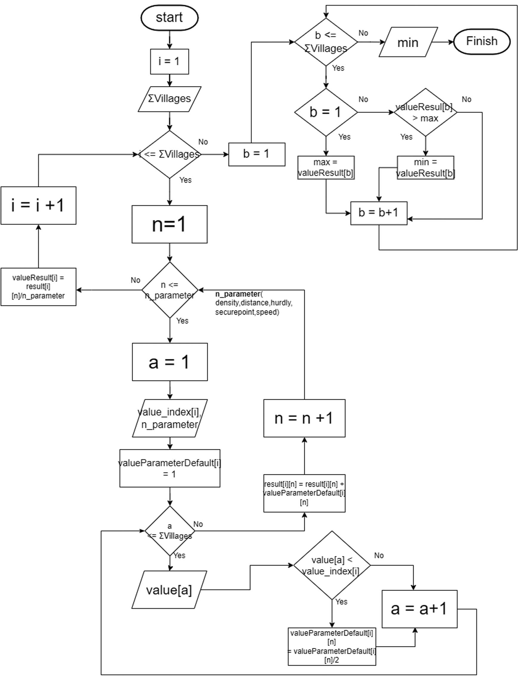
The flowchart of the sister village ant colony algorithm.
2.2.2 Parameters in ACO
Conceptually, the ACO algorithm involves many parameters including distance, speed, hurdle, density, and secure point. The parameters of ACO are more comprehensive compared to other methods such as the least cost path examination that usually deploys only one parameter – road capacity [55]. Model simulations and calculations are done by the aggregation of existing indicators and continue to calculate and determine the shortest and most effective evacuation path including the mitigation of lava flows that will affect the evacuation [56]. We used five parameters in the ACO that were also adopted by Batmetan [50]. The five parameters are distance, speed, hurdle, density, and secure point [52].
The distance (in km) is used to measure the distance from the sending village to the destination village. The closer the distance to the destination village, the greater the default value (the more priority village destination). The parameters are calculated as follows:
where
The speed (in km/h) assessed is the velocity at which the community moves from the sending village to the destination village. The speed value is affected by a number of obstacles. The fewer the obstacles, the higher the value of the displacement speed and the faster are people evacuated. The parameters are calculated as follows:
where W s is the speed weight, s vi is the speed to i, and s vindex is the speed index.
Hurdle, measured in units of the number of obstacles, is an obstacle that is encountered by the community if they go to the destination village. The obstacles are identified as follows: the number of crossroads, forks in the road, proper road infrastructure, and the ups and downs of winding roads or roads. The smaller the hurdle value, the more it becomes a priority in determining the sister village. The parameters are calculated as follows:
where W h is the hurdle weight, h vi is the hurdle to i, and h vindex is the hurdle index.
Density is the measure of the amount of exposure of a track. The density assessed from this parameter is the density of the destination village and traffic density if a volcanic eruption occurs [57]. The smaller the density value, the more it becomes a priority in the selection of sister villages. The parameters are calculated as follows:
where W ds is the density weight, dsvi is the density to i, and dsvindex is the density index. A secure point is the measure of the number of points to be traversed secured on a track. It is assumed that the starting and end routes are easily known by the people, especially the communities who live around the volcano. Secure points or safe points that are assessed in this parameter are the readiness of the infrastructure of the buffer village, safe from lava flows, and not included in the red zone. The higher the secure point value, the safer the village is to become a buffer village. The parameters are calculated as follows:
The minimum point is 2 as the value indicates that the area has the infrastructure and buffer villages, safe from lava flows and is not in a red zone. The determination of values 1 and 2 is based on mathematical assumptions:
where
The minimum point is 300 because the safe distance to build an evacuation barrack is 300 m from the river bank where the lava flows. The 300 values are determined based on the Regional Disaster Management Agency policy that states a recommendation of the safe area should be less than 300 m from the river where the lava flows [58].
3 Results and discussion
3.1 Disaster-prone areas
The focus of this study is the Sleman Regency covering an area of 20 km from the epicenter of the eruption. The 20 km area is stipulated by the government and community as a disaster-prone area (Kawasan Rawan Bencana/KRB) with three levels: 1) KRB III, radius from 0 to 10 km, which is the most vulnerable zone; 2) KRB II, radius from 10 to 15 km; and 3) KRB I, radius from 15 to 20 km, which is estimated to be the least vulnerable area.
As illustrated in Figure 3, it can be seen that each zone covers several sub-Regencies (Kecamatan) that administer villages and sub-villages (Desa and Dusun) with the following characteristics:
KRB III (red circle) consists of four sub-Regencies: Cangkringan, Pakem, Turi, and Ngemplak. The four sub-regencies include 9 villages and 22 sub-villages. The sub-villages in the KRB III are the northernmost and are the closest to the epicenter point of eruption; thus, they are the most vulnerable areas.
KRB II (yellow circle) consists of 4 sub-regencies, 10 villages, and 49 sub-villages.
KRB I (green circle) consists of a number of villages traversed by five river watersheds. In calculating the parameters to validate the sister villages with the ant colony, pseudocode was developed as a translation of the algorithm. Pseudocode is an informal way to write algorithms or computer program designs. It aims to obtain rapid ideas and simplify reading algorithms without strict grammatical rules. Often, algorithms are presented using pseudocode as it can be read and understood by programmers who are familiar with different programming languages. Pseudocode allows one to include several control structures such as While, If-then-else, Repeat-until, and for any case, which are present in many high-level languages [59].
Disaster-prone areas from level 1 to level 3.
3.2 Validation
3.2.1 Validation of the sister village between Girikerto and Trimulyo
Girikerto village is located on the slopes of Mount Merapi about 12 km from the peak of Merapi and the area is included in the danger zone of Mount Merapi. The village has an area of about 13.07 km2 with a population of 7,712 people divided into 13 hamlets. Girikerto has a northern boundary of Mount Merapi, east of Pendowoharjo village, Pakembinangun Regency, south of Trimulyo, Harjobinangun, and west of Caturharjo village. Based on community members’ consensus, Girikerto and Trimulyo have agreed to become sister villages. Furthermore, ACO is used to analyze whether the selection route between both villages is valid (Figure 4).
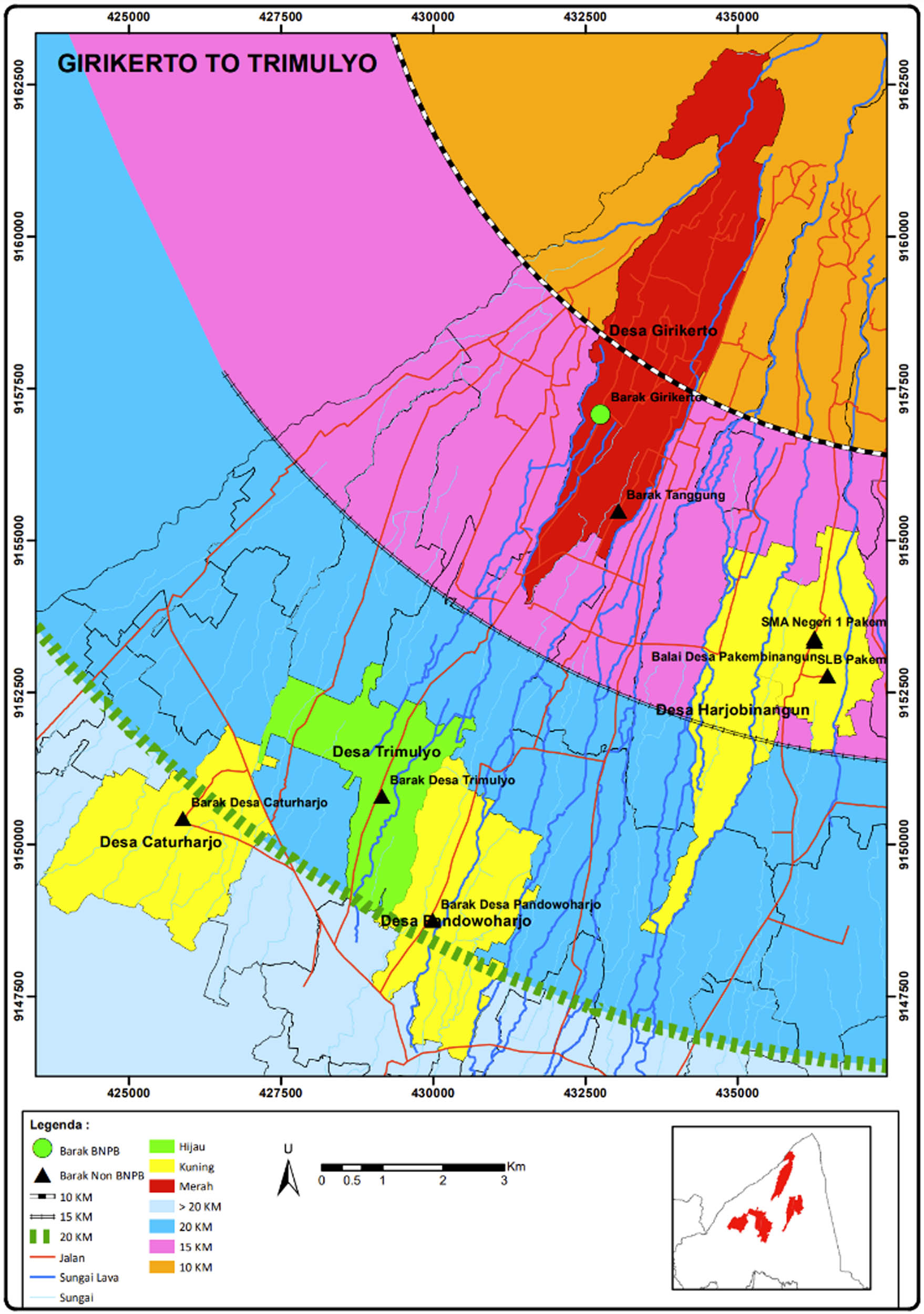
The map of Girikerto (in red) and the five surrounding villages.
The parameters in ACO are used in selecting and determining the best village among the five villages surrounding Girikerto for the evacuation destination. This simulation is to determine whether the selection of sister villages is the most reliable choice in accordance with ACO. Table 1 shows the visualization taken from the MGIS-Sister Village to show the surrounding area with the proposal receiving villages from Girikerto (red zone) and the recipient Trimulyo (green zone). To prove this, the other four villages have been selected including Pendowoharjo, Pakembinangun, Harjobinangun, and Caturharjo.
From Girikerto to the five closest villages
| Village | Distance (km) | Density | Hurdle | Secure point | Speed |
|---|---|---|---|---|---|
| Pendowoharjo | 4.4 | 10,924 | 34 | Secure | 34 |
| Pakembinangun | 4.2 | 6,488 | 36 | Insecure | 36 |
| Trimulyo | 2.6 | 9,238 | 20 | Secure | 20 |
| Harjobinangun | 3.4 | 5,924 | 29 | Insecure | 29 |
| Caturharjo | 9.1 | 14,411 | 93 | Secure | 93 |
After calculating using the five parameters (Table 2), the highest average is from Trimulyo. This average value shows that Trimulyo is the best village to be an evacuation destination. The results of this calculation proved the validity of the sister village and the agreement between the Girikerto and Trimulyo villages. The visualization of the location of the five villages is shown in Figure 5, which is taken from the MGIS-Sister Village system.
Parameters’ conversion and the mean result from Girikerto to the five closest villages
| Village | Distance | Density | Hurdle | Secure point | Speed | Mean |
|---|---|---|---|---|---|---|
| Pendowoharjo | 0.125 | 0.25 | 0.25 | 2 | 0.25 | 0.625 |
| Pakembinangun | 0.25 | 1 | 0.125 | 0.25 | 0.125 | 0.35 |
| Trimulyo | 1 | 0.5 | 1 | 1 | 1 | 0.9 |
| Harjobinangun | 0.5 | 2 | 0.5 | 0.125 | 0.5 | 0.725 |
| Caturharjo | 0.625 | 0.125 | 0.0625 | 0.5 | 0.0625 | 0.275 |
Bold row indicates that the village has the highest average score among the others based on calculations of the parameters.
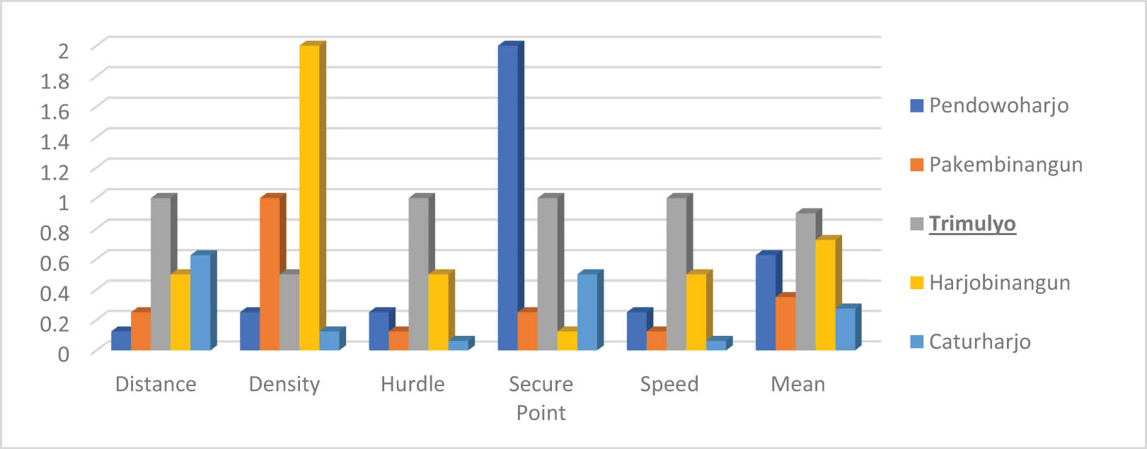
Parameters’ conversion and the mean result from Girikerto to the five closest villages.
3.2.2 Validation of the sister village between Hargobinangun and Pakembinangun
The simulation using ACO selects the five nearest villages (Table 3) and calculates all parameters to validate whether Pakembinangen is the most reliable village for the evacuation process.
From the Hargobinangun village to the five closest villages
| Village | Distance (km) | Density | Hurdle | Secure point | Speed |
|---|---|---|---|---|---|
| Pakembinangun | 6.4 | 6,488 | 58 | Secure | 58 |
| Harjobinangun | 89 | 5,924 | 108 | Secure | 108 |
| Wukirsari | 10 | 9,786 | 96 | Secure | 96 |
| Donoharjo | 14.2 | 7,677 | 87 | Secure | 87 |
| Bimomartani | 17 | 6,739 | 208 | Insecure | 208 |
After calculating the five parameters (Table 4 and Figure 5), the highest average is from Pakembinangun. This average value shows that Pakembinangan is the best village to be a destination for community evacuations from the sending village of Hargobinangun. The results of this calculation proved the validity of the agreement between both villages (Figure 6).
Parameters’ conversion and the mean result from Hargobinangun to the five closest villages
| Village | Distance | Density | Hurdle | Secure point | Speed | Mean |
|---|---|---|---|---|---|---|
| Pakembinangun | 1 | 1 | 1 | 2 | 1 | 1.2 |
| Harjobinangun | 0.5 | 2 | 0.125 | 1 | 0.125 | 0.75 |
| Wukirsari | 0.25 | 0.125 | 0.25 | 0.5 | 0.25 | 0.275 |
| Donoharjo | 0.125 | 0.25 | 0.5 | 0.25 | 0.5 | 0.325 |
| Bimomartani | 0.0625 | 0.5 | 0.0625 | 0.125 | 0.0625 | 0.1625 |
Bold row indicates that the village has the highest average score among the others based on calculations of the parameters.
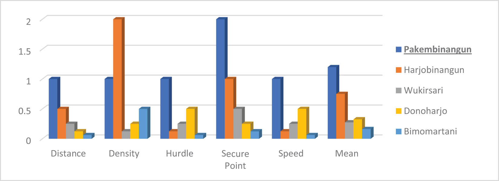
Parameters’ conversion and the mean result from Hargobinangun to the five closest villages.
3.2.3 Validation of the sister village between Candibinangun and Harjobinangun
Tables 5 and 6 show a mathematical calculation based on the parameters in VASCO. The calculations are carried out on the five closest villages to obtain and validate the best villages for evacuation.
From Candibinangun to the five closest villages
| Village | Distance (km) | Density | Hurdle | Secure point | Speed |
|---|---|---|---|---|---|
| Harjobinangun | 1.4 | 5,924 | 16 | Secure | 16 |
| Wukirsari | 5.5 | 9,786 | 67 | Insecure | 67 |
| Donoharjo | 4.6 | 7,677 | 40 | Secure | 40 |
| Bimomartani | 9.8 | 6,739 | 87 | Insecure | 87 |
| Umbulmartani | 3.4 | 11,276 | 43 | Insecure | 43 |
Parameters’ conversion and the mean result from Candibinangun to the five closest villages
| Village | Distance | Density | Hurdle | Secure point | Speed | Mean |
|---|---|---|---|---|---|---|
| Harjobinangun | 1 | 2 | 1 | 2 | 1 | 1.4 |
| Wukirsari | 0.125 | 0.25 | 0.125 | 0.5 | 0.125 | 0.225 |
| Donoharjo | 0.25 | 0.5 | 0.5 | 1 | 0.5 | 0.55 |
| Bimomartani | 0.0625 | 1 | 0.0625 | 0.25 | 0.0625 | 0.2875 |
| Umbulmartani | 0.5 | 0.125 | 0.25 | 0.125 | 0.25 | 0.25 |
Bold row indicates that the village has the highest average score among the others based on calculations of the parameters.
After calculating the five parameters (Table 5 and Figure 7), the highest average is from the village of Harjobinagun. This average value shows that Harjobinangun is the best village to be a destination for community evacuation from Candibinganung. The results of this calculation proved the validity of the agreement between both villages. This also shows that the sister village evacuation route is effective and ACO is able to validate the route.
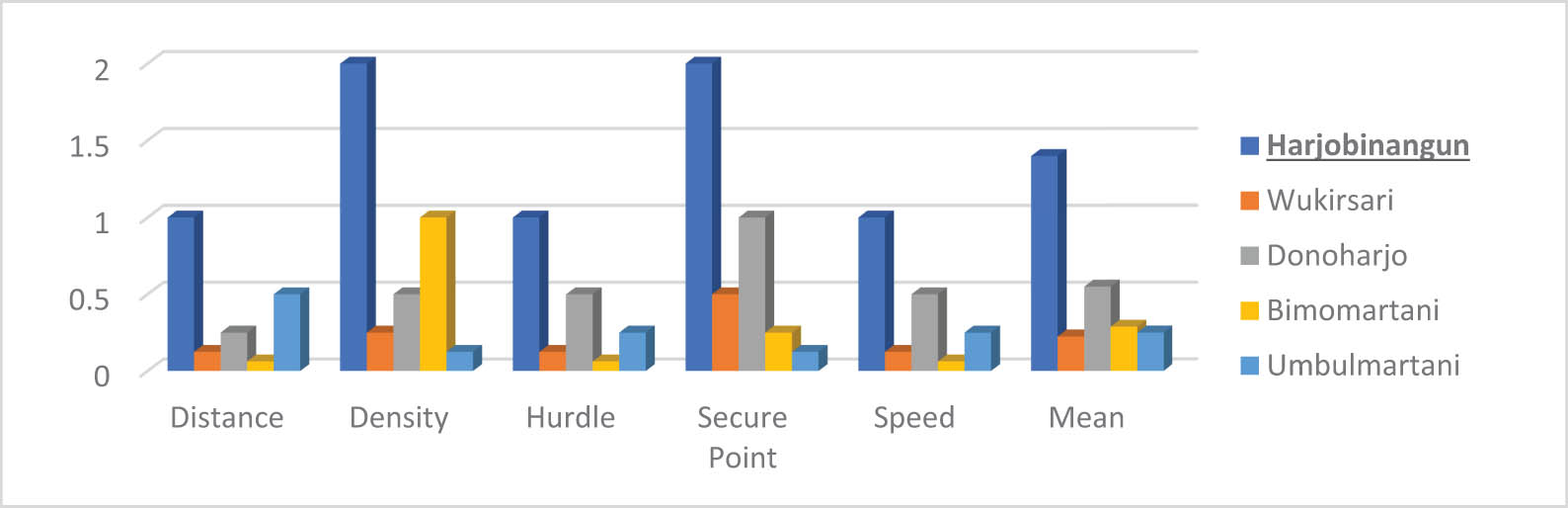
Parameters’ conversion and the mean result from Candibinangun to the five closest villages.
3.2.4 Validation of the sister village between Kepuharjo and Wukisari
Using the parameters, the best route and destination for the Kepuharjo can be seen from the following calculation involving five surrounding villages (Table 7).
From Kepuharjo to the five closest villages
| Village | Distance (km) | Density | Hurdle | Secure point | Speed |
|---|---|---|---|---|---|
| Sindumartani | 11.9 | 7,100 | 82 | Insecure | 82 |
| Wukirsari | 3.7 | 9,786 | 34 | Secure | 34 |
| Donoharjo | 14.1 | 7,677 | 130 | Secure | 130 |
| Bimomartani | 12.5 | 6,739 | 72 | Insecure | 72 |
| Umbulmartani | 14.8 | 11,276 | 104 | Insecure | 104 |
After calculating the five parameters, the highest average is from Wukisari village. This average value indicates that Wukisari is the best village to be the destination for community evacuation from Kepuharjo. The results of this calculation proved the validity of the agreement between both villages (Table 8 and Figure 8).
Parameters’ conversion and the mean result from Kepuharjo to the five closest villages
| Village | Distance | Density | Hurdle | Secure point | Speed | Mean |
|---|---|---|---|---|---|---|
| Sindumartani | 0.25 | 1 | 0.25 | 0.5 | 0.25 | 0.45 |
| Wukirsari | 1 | 0.25 | 1 | 1 | 1 | 0.85 |
| Donoharjo | 0.125 | 0.5 | 0.0625 | 2 | 0.0625 | 0.55 |
| Bimomartani | 0.5 | 2 | 0.5 | 0.25 | 0.5 | 0.75 |
| Umbulmartani | 0.0625 | 0.125 | 0.125 | 0.125 | 0.125 | 0.1125 |
Bold row indicates that the village has the highest average score among the others based on calculations of the parameters.
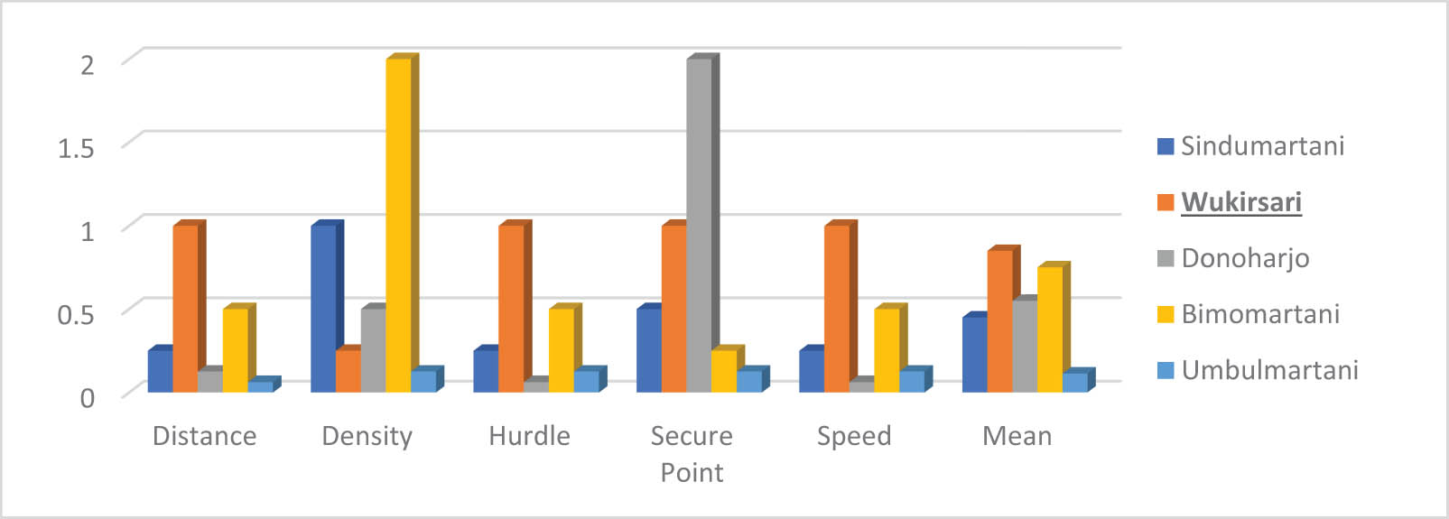
Parameters’ conversion and the mean result from Kepuharjo to the five closest villages.
4 Discussion
From the results of the analysis of the four evacuation routes in the sister village program using ACO, it shows that the routes agreed upon by the community in the area are valid. First, from Girikerto to Trimulyo, the highest average is from Trimulyo village (0.9 points). Second, from Hargobinangun to Pakembinangun, the highest average is from Pekembinangun (1.2 points). Third, from Candibinangun to Harjobinangun, the highest average is from Harjobinangun (1.4 points). Fourth, from Kepuharjo to Wukirsari, the highest average is from Wukirsari (0.85 points).
From the examination of the sister village using ACO, it can be proven that the selected evacuation route and partnering with the villages have met the criteria based on several parameters such as distance, speed, hurdle, density, and secure point. The best preference or the highest value based on validation and calculation using ACO has proved that the sister village evacuation scenarios have the best evacuation routes, both fastest and safest. Thus, the development of sister villages is necessary to be disseminated and further promoted using technology so that it can be accessed by the communities.
5 Conclusions
This study illustrates the construction of the sister village system that can help educate communities in Mount Merapi, specifically those in the prone-disaster villages. Sister village as an evacuation route in Mount Merapi, Yogyakarta, Indonesia, has never been validated or analyzed mathematically. Thus, using the ACO algorithm to validate its route is the novelty of this research. Furthermore, after the validation of the sister village evacuation route, a new platform, the integration of GIS and the sister village, is developed. After calculating the five parameters, the highest average is from Wukisari village. This average value indicates that Wukisari village is the best village to be the destination for community evacuation from Kepuharjo village. The results of this calculation prove the agreement between both villages mathematically. ACO algorithm can be used as a metaheuristic algorithm to optimize evacuation routes. It can consider distance, safety, road capacity, and population density to determine an optimal or near-optimal route. However, a study about ACO can be developed on how it deals with complex, dynamic problem domains that may not be under the established evacuation planning schemes, such as sister villages, so dynamic updates in the algorithm need to be carried out.
Acknowledgments
The author would like to thank the Hohai University and colleagues and laboratory staff who have facilitated this research.
-
Author contributions: Muhammad Aziz, in this study, played a role in collecting data, reducing data, and describing research results. He also created model simulations and calculations of the ACO algorithm, which is the main issue in this research. Meanwhile, Prof. Wu Taixia, in this study, advised as a mentor, validated data and ensured scientific principles in this research.
-
Conflict of interest: Authors state no conflict of interest.
References
[1] Stothers RB. The Great Tambora Eruption in 1815 and its aftermath. Science. 1984 Jun;224(4654):1191–8.10.1126/science.224.4654.1191Suche in Google Scholar PubMed
[2] Winchester S. Krakatoa: The day the world exploded. UK: Penguin: 2004. p. 416.Suche in Google Scholar
[3] Hadi BS, Setyawati SAA. Analysis of Merapi volcano’s danger post-eruption in 2010. In: Seminar 9th PAHMI. International Conference on Malaysia-Indonesia Relation; 2015. p. 21–30.Suche in Google Scholar
[4] Resources GA of the M of E and M. G. Merapi - Sejarah Letusan. Resources, Geological Agency of the Ministry of Energy and Mineral; 2014.Suche in Google Scholar
[5] Neumann Van Padang M. History of the volcanology in the former Netherlands East Indies. Scr Geol. 1983;71:1–76.Suche in Google Scholar
[6] Programme UND. Institutionalizing post-disaster recovery: Learning from Mentawai Tsunami and Merapi eruption. Recovery Framew Case Study; 2014. p. 1–52.Suche in Google Scholar
[7] Voight B, Constantine EK, Siswowidjoyo S, Torley R. Historical eruptions of Merapi Volcano, Central Java, Indonesia, 1768–1998. J Volcanol Geotherm Res. 2000 Jul;100(1–4):69–138.10.1016/S0377-0273(00)00134-7Suche in Google Scholar
[8] Elysia V, Wihadanto A. The Sister Village Program: Promoting Community Resilience after Merapi Eruption. Indones J Plan Dev. 2018 Feb;3(1):32.10.14710/ijpd.3.1.32-43Suche in Google Scholar
[9] Arouri M, Nguyen C, Ben YA. Natural disasters, household welfare, and resilience: Evidence from Rural Vietnam. World Dev. 2015 Jun;70:59–77.10.1016/j.worlddev.2014.12.017Suche in Google Scholar
[10] Lindell MK, Prater CS. Assessing community impacts of natural disasters. Nat Hazards Rev. 2003;4(4):176–85.10.1061/(ASCE)1527-6988(2003)4:4(176)Suche in Google Scholar
[11] Pelling M, Özerdem A, Barakat S. The macro-economic impact of disasters. Prog Dev Stud. 2002 Oct;2(4):283–305.10.1191/1464993402ps042raSuche in Google Scholar
[12] De Haen H, Hemrich G. The economics of natural disasters: implications and challenges for food security. Agric Econ. 2007 Dec;37(S1):31–45.10.1111/j.1574-0862.2007.00233.xSuche in Google Scholar
[13] Ashari A. Geomorphology of the southern Flank Of Merapi Volcano in relation to the potential hazards and natural resources: A review. Geomedia Maj Ilm dan Inf Kegeografian. 2018 May;15(2):183–92.10.21831/gm.v15i2.19556Suche in Google Scholar
[14] Hadi BS, Setyowati S, Ashari A. Pengembangan sistem informasi bahaya erupsi untuk Pengelolaan Kebencanaan di Lereng Selatan Gunungapi Merapi. Maj Geogr Indones. 2016;26(2):139.Suche in Google Scholar
[15] Surono, Jousset P, Pallister J, Boichu M, Buongiorno MF, Budisantoso A, et al. The 2010 explosive eruption of Java’s Merapi volcano—A ‘100-year’ event. J Volcanol Geotherm Res. 2012 Oct;241–242:121–35.10.1016/j.jvolgeores.2012.06.018Suche in Google Scholar
[16] Bencana-BNPB BNP. Rencana Aksi Rehabilitasi dan Rekontruksi Wilayah Pasca Bencana Erupsi Gunung Merapi di Propinsi DI. Yogyak dan Jawa Teng tahun. 2011;2013:26–42.Suche in Google Scholar
[17] Subandriyo. Sejarah Erupsi Gunung Merapi dan Dampaknya Terhadap Kawasan Borobudur. Menyelamatkan Candi Borobudur dari Erupsi Merapi, Balai Konservasi Peninggalan Borobudur. Magelang; 2011. p. 86–96.Suche in Google Scholar
[18] Jumadi Carver S, Quincey D. A conceptual design of spatio-temporal agent-based model for volcanic evacuation. Systems. 2017 Nov;5(4):53.10.3390/systems5040053Suche in Google Scholar
[19] Aymaz S, Cavdar T, Cavdar AD. Fire evacuation route determination based on particle swarm optimization. In: 2017 International Artificial Intelligence and Data Processing Symposium (IDAP). IEEE; 2017. p. 1–4.10.1109/IDAP.2017.8090169Suche in Google Scholar
[20] Goto H, Ohta A, Matsuzawa T, Takimoto M, Kambayashi Y, Takeda M. A guidance system for wide-area complex disaster evacuation based on ant colony optimization. In: Proceedings of the 8th International Conference on Agents and Artificial Intelligence. SCITEPRESS - Science and Technology Publications; 2016. p. 262–8.10.5220/0005819502620268Suche in Google Scholar
[21] Forcael E, González V, Orozco F, Vargas S, Pantoja A, Moscoso P. Ant colony optimization model for Tsunamis evacuation routes. Comput Civ Infrastruct Eng. 2014 Nov;29(10):723–37.10.1111/mice.12113Suche in Google Scholar
[22] Dorigo M, Maniezzo V, Colorni A. Ant system: Optimization by a colony of cooperating agents. IEEE Trans Syst Man, Cybern Part B Cybern. 1996;26(1):14.10.1109/3477.484436Suche in Google Scholar PubMed
[23] Sutariya D, Tech M. A survey of ant colony based routing algorithms for manet. Eur Sci J. 2013;3(December):83.Suche in Google Scholar
[24] Wang Y, Wang L, Chen G, Cai Z, Zhou Y, Xing L. An improved ant colony optimization algorithm to the periodic vehicle routing problem with time window and service choice. Swarm Evol Comput. 2020 Jun;55:100675.10.1016/j.swevo.2020.100675Suche in Google Scholar
[25] Alaya I, Solnon C, Ghedira K. Ant colony optimization for multi-objective optimization problems. In: 19th IEEE International Conference on Tools with Artificial Intelligence (ICTAI 2007). IEEE; 2007. p. 450–7.10.1109/ICTAI.2007.108Suche in Google Scholar
[26] Hardiansyah MI, Balijepalli C, Priyanto S. Analysing vulnerability of road network and guiding evacuees to sheltered areas: Case study of Mt Merapi, Central Java, Indonesia. Case Stud Transp Policy. 2020 Dec;8(4):1329–40.10.1016/j.cstp.2020.09.004Suche in Google Scholar
[27] Hardiansyah Priyanto S, Muthohar I, Suparma LB. Identifying road network vulnerability during disaster case study: Road network evacuation in Mount Merapi eruption. Songklanakarin J Sci Technol. 2019;41(4):769–76.Suche in Google Scholar
[28] Sopha BM, Achsan RED, Asih AMS. Mount Merapi eruption. J Humanit Logist Supply Chain Manag. 2019 Nov;9(2):292–322.10.1108/JHLSCM-05-2018-0035Suche in Google Scholar
[29] Kharis FA, Dwinanto B, Putri M, Widana K. Sister village sebagai alternatif penanganan pengungsi erupsi gunung agung. J Dialog Penanggulangan Bencana. 2019;10:125.Suche in Google Scholar
[30] Margono M, Priyo P, Haq ALA. The sister village program: evaluation of refugee camp in Deyangan Village, Magelang District in Merapi Preparedness. In: Proceedings of the 2nd Borobudur International Symposium on Humanities and Social Sciences, BIS-HSS 2020. 2021, Magelang, Central Java, Indonesia: EAI; 18 November 2020. p. 1–7.10.4108/eai.18-11-2020.2311720Suche in Google Scholar
[31] Indonesia S. Population and Sex Ratio by Regency/Municipality in Jawa Tengah Province; 2019.Suche in Google Scholar
[32] Indonesia S. Number of population estimation by Regency/City in D.I. Yogyakarta (People). Kabupaten Kota D.I.Y; 2022. p. 2020–2.Suche in Google Scholar
[33] Mei ETW, Lavigne F, Picquout A, de Bélizal E, Brunstein D, Grancher D, et al. Lessons learned from the 2010 evacuations at Merapi volcano. J Volcanol Geotherm Res. 2013 Jul;261:348–65.10.1016/j.jvolgeores.2013.03.010Suche in Google Scholar
[34] Tasic J, Amir S. Informational capital and disaster resilience: the case of Jalin Merapi. Disaster Prev Manag. 2016 Jun;25(3):395–411.10.1108/DPM-07-2015-0163Suche in Google Scholar
[35] Zarodi H. Pemanfaatan Webgis Dalam Mendukung Program Desa Bersaudara Di Kabupaten Magelang. Semin Nas Geomatika. 2018 Feb;2:223.10.24895/SNG.2017.2-0.461Suche in Google Scholar
[36] Chasanah F, Sakakibara H. Development of an agent-based evacuation model for vulnerable people in the Southeast Area of Mount Merapi, Indonesia. SSRN Electron J. 2022;17:12.10.2139/ssrn.4062492Suche in Google Scholar
[37] Mahmud AK, Sidiq WABN. Aplikasi Webgis dalam Mendukung Program Sister Village Sebagai Upaya Pengurangan Risiko Bencana Erupsi Gunung Merapi di Desa Paten Kecamatan Dukun Kabupaten Magelang. Geo-Image. 2021;10(1):47.Suche in Google Scholar
[38] Hadi S. Sister village program (Indonesia Merapi Eruption), Ministry of national development planning/Bappenas. Republic of Indonesia. Switzerland: GP20 Steering Group Meeting Geneva; 2020:30–6.Suche in Google Scholar
[39] BNPB. The sister Village Program Indonesia. Prepared for high-level panel of internal displacement. National Disaster Management Authority; 2020. p. 1–12.Suche in Google Scholar
[40] Sari KP, Oktradiksa A, Setyawan A, Priyo P. The Recontigencies of Merapi Eruption Disasters in Implementation of Sister Village. J Community Serv Engagem. 2020;2(1):30–6.Suche in Google Scholar
[41] Moncayo-Martínez LA, Zhang DZ. Multi-objective ant colony optimisation: A meta-heuristic approach to supply chain design. Int J Prod Econ. 2011 May;131(1):407–20.10.1016/j.ijpe.2010.11.026Suche in Google Scholar
[42] Singhal K, Sahu S. Fire evacuation using ant colony optimization algorithm. Int J Comput Appl. 2016 Apr;139(8):17–20.10.5120/ijca2016909239Suche in Google Scholar
[43] Zhang Y, Guo J, Zhu R, Zhao Z, Wang L. Path planning based on improved ant colony algorithm. In: 2020 International Conference on Virtual Reality and Intelligent Systems (ICVRIS). IEEE; 2020. p. 946–9.10.1109/ICVRIS51417.2020.00230Suche in Google Scholar
[44] Iqbal M, Zarlis M, Tulus T, Mawengkang H. Pendekatan Pengembangan Metaheuristik dalam optimisasi kombinatorial. Pros Semin Nas Ris Inf Sci. 2019 Nov;1(1):1193.10.30645/senaris.v1i0.135Suche in Google Scholar
[45] Zarman A, Irfan M, Uriawan W. Implementasi algoritma ant colony optimization pada aplikasi pencarian lokasi tempat Ibadah Terdekat di Kota Bandung. J Online Inf. 2016 Jun;1(1):6.10.15575/join.v1i1.4Suche in Google Scholar
[46] Kaveh A, Shojaee S. Optimal design of skeletal structures using ant colony optimization. Int J Numer Methods Eng. 2007 Apr;70(5):563–81.10.1002/nme.1898Suche in Google Scholar
[47] Picard D, Revel A, Cord M. An application of swarm intelligence to distributed image retrieval. Inf Sci (Ny). 2012 Jun;192:71–81.10.1016/j.ins.2010.03.003Suche in Google Scholar
[48] Schoonderwoerd R, Holland O, Bruten J. Ant-like agents for load balancing in telecommunications networks. In: Proceedings of the first international conference on Autonomous agents - AGENTS ’97. New York, USA: ACM Press; 1997. p. 209–16.10.1145/267658.267718Suche in Google Scholar
[49] Nezamabadi-pour H, Saryazdi S, Rashedi E. Edge detection using ant algorithms. Soft Comput. 2006 May;10(7):623–8.10.1007/s00500-005-0511-ySuche in Google Scholar
[50] Batmetan JR. Algoritma ant colony optimization (ACO) untuk Pemilihan Jalur Tercepat Evakuasi Bencana Gunung Lokon Sulawesi Utara. AITI. 2016;13(1):31–48.Suche in Google Scholar
[51] Jumadi J, Carver SJ, Quincey DJ. An agent-based evaluation of varying evacuation scenarios in Merapi: Simultaneous and staged. Geosciences. 2019 Jul;9(7):317.10.3390/geosciences9070317Suche in Google Scholar
[52] Wang G. A comparative study of cuckoo algorithm and ant colony algorithm in optimal path problems. Wang Y, editor. MATEC Web of Conferences. Vol. 232; 2018 Nov. p. 03003.10.1051/matecconf/201823203003Suche in Google Scholar
[53] Duan H, Yu Y, Zou J, Feng X. Ant colony optimization-based bio-inspired hardware: survey and prospect. Trans Inst Meas Control. 2012 Apr;34(2–3):318–33.10.1177/0142331210366689Suche in Google Scholar
[54] Zong X, Xiong S, Fang Z, Li Q. Multi-ant colony system for evacuation routing problem with mixed traffic flow. In: IEEE Congress on Evolutionary Computation. IEEE; 2010. p. 1–6.10.1109/CEC.2010.5586326Suche in Google Scholar
[55] Putri LKR, Maryono M. Assessing evacuation route against mount Merapi hazard by using least cost path method in Mriyan-Boyolali, Indonesia. IOP Conf Ser Earth Env Sci. 2018 Feb;123(1):012008.10.1088/1755-1315/123/1/012008Suche in Google Scholar
[56] Mutakhiroh I, Saptono F, Hasanah N, Wiryadinata R. Pemanfaatan metode heuristik dalam pencarian jalur terpendek dengan algoritma semut dan algoritma genetika. In:SNATI (Seminar Nasional Aplikasi Teknologi Informasi) 2007; 2007.Suche in Google Scholar
[57] Oppenheimer C. Limited global change due to the largest known Quaternary eruption, Toba ≈74kyr BP? Quat Sci Rev. 2002 Aug;21(14–15):1593–609.10.1016/S0277-3791(01)00154-8Suche in Google Scholar
[58] ADREANTO ATD. Pelaksanaan Penggunaan Tanah Kas Desa Untuk Tempat Pemakaman Di Kecamatan Dukun, Kabupaten Magelang Berdasarkan Peraturan Daerah Kabupaten Magelang Nomor 5 Tahun 2011 Tentang Rencana Tata Ruang Wilayah Kabupaten Magelang Tahun 2010-2030. UAJY; 2013.Suche in Google Scholar
[59] Handayani D, Herliansyah MK, Hartono B, Sopha BM Community behavior during the evacuation of Mount Merapi eruption disaster. In: 2016 IEEE International Conference on Industrial Engineering and Engineering Management (IEEM). IEEE; 2016. p. 276–80.10.1109/IEEM.2016.7797880Suche in Google Scholar
© 2023 the author(s), published by De Gruyter
This work is licensed under the Creative Commons Attribution 4.0 International License.
Artikel in diesem Heft
- Regular Articles
- Diagenesis and evolution of deep tight reservoirs: A case study of the fourth member of Shahejie Formation (cg: 50.4-42 Ma) in Bozhong Sag
- Petrography and mineralogy of the Oligocene flysch in Ionian Zone, Albania: Implications for the evolution of sediment provenance and paleoenvironment
- Biostratigraphy of the Late Campanian–Maastrichtian of the Duwi Basin, Red Sea, Egypt
- Structural deformation and its implication for hydrocarbon accumulation in the Wuxia fault belt, northwestern Junggar basin, China
- Carbonate texture identification using multi-layer perceptron neural network
- Metallogenic model of the Hongqiling Cu–Ni sulfide intrusions, Central Asian Orogenic Belt: Insight from long-period magnetotellurics
- Assessments of recent Global Geopotential Models based on GPS/levelling and gravity data along coastal zones of Egypt
- Accuracy assessment and improvement of SRTM, ASTER, FABDEM, and MERIT DEMs by polynomial and optimization algorithm: A case study (Khuzestan Province, Iran)
- Uncertainty assessment of 3D geological models based on spatial diffusion and merging model
- Evaluation of dynamic behavior of varved clays from the Warsaw ice-dammed lake, Poland
- Impact of AMSU-A and MHS radiances assimilation on Typhoon Megi (2016) forecasting
- Contribution to the building of a weather information service for solar panel cleaning operations at Diass plant (Senegal, Western Sahel)
- Measuring spatiotemporal accessibility to healthcare with multimodal transport modes in the dynamic traffic environment
- Mathematical model for conversion of groundwater flow from confined to unconfined aquifers with power law processes
- NSP variation on SWAT with high-resolution data: A case study
- Reconstruction of paleoglacial equilibrium-line altitudes during the Last Glacial Maximum in the Diancang Massif, Northwest Yunnan Province, China
- A prediction model for Xiangyang Neolithic sites based on a random forest algorithm
- Determining the long-term impact area of coastal thermal discharge based on a harmonic model of sea surface temperature
- Origin of block accumulations based on the near-surface geophysics
- Investigating the limestone quarries as geoheritage sites: Case of Mardin ancient quarry
- Population genetics and pedigree geography of Trionychia japonica in the four mountains of Henan Province and the Taihang Mountains
- Performance audit evaluation of marine development projects based on SPA and BP neural network model
- Study on the Early Cretaceous fluvial-desert sedimentary paleogeography in the Northwest of Ordos Basin
- Detecting window line using an improved stacked hourglass network based on new real-world building façade dataset
- Automated identification and mapping of geological folds in cross sections
- Silicate and carbonate mixed shelf formation and its controlling factors, a case study from the Cambrian Canglangpu formation in Sichuan basin, China
- Ground penetrating radar and magnetic gradient distribution approach for subsurface investigation of solution pipes in post-glacial settings
- Research on pore structures of fine-grained carbonate reservoirs and their influence on waterflood development
- Risk assessment of rain-induced debris flow in the lower reaches of Yajiang River based on GIS and CF coupling models
- Multifractal analysis of temporal and spatial characteristics of earthquakes in Eurasian seismic belt
- Surface deformation and damage of 2022 (M 6.8) Luding earthquake in China and its tectonic implications
- Differential analysis of landscape patterns of land cover products in tropical marine climate zones – A case study in Malaysia
- DEM-based analysis of tectonic geomorphologic characteristics and tectonic activity intensity of the Dabanghe River Basin in South China Karst
- Distribution, pollution levels, and health risk assessment of heavy metals in groundwater in the main pepper production area of China
- Study on soil quality effect of reconstructing by Pisha sandstone and sand soil
- Understanding the characteristics of loess strata and quaternary climate changes in Luochuan, Shaanxi Province, China, through core analysis
- Dynamic variation of groundwater level and its influencing factors in typical oasis irrigated areas in Northwest China
- Creating digital maps for geotechnical characteristics of soil based on GIS technology and remote sensing
- Changes in the course of constant loading consolidation in soil with modeled granulometric composition contaminated with petroleum substances
- Correlation between the deformation of mineral crystal structures and fault activity: A case study of the Yingxiu-Beichuan fault and the Milin fault
- Cognitive characteristics of the Qiang religious culture and its influencing factors in Southwest China
- Spatiotemporal variation characteristics analysis of infrastructure iron stock in China based on nighttime light data
- Interpretation of aeromagnetic and remote sensing data of Auchi and Idah sheets of the Benin-arm Anambra basin: Implication of mineral resources
- Building element recognition with MTL-AINet considering view perspectives
- Characteristics of the present crustal deformation in the Tibetan Plateau and its relationship with strong earthquakes
- Influence of fractures in tight sandstone oil reservoir on hydrocarbon accumulation: A case study of Yanchang Formation in southeastern Ordos Basin
- Nutrient assessment and land reclamation in the Loess hills and Gulch region in the context of gully control
- Handling imbalanced data in supervised machine learning for lithological mapping using remote sensing and airborne geophysical data
- Spatial variation of soil nutrients and evaluation of cultivated land quality based on field scale
- Lignin analysis of sediments from around 2,000 to 1,000 years ago (Jiulong River estuary, southeast China)
- Assessing OpenStreetMap roads fitness-for-use for disaster risk assessment in developing countries: The case of Burundi
- Transforming text into knowledge graph: Extracting and structuring information from spatial development plans
- A symmetrical exponential model of soil temperature in temperate steppe regions of China
- A landslide susceptibility assessment method based on auto-encoder improved deep belief network
- Numerical simulation analysis of ecological monitoring of small reservoir dam based on maximum entropy algorithm
- Morphometry of the cold-climate Bory Stobrawskie Dune Field (SW Poland): Evidence for multi-phase Lateglacial aeolian activity within the European Sand Belt
- Adopting a new approach for finding missing people using GIS techniques: A case study in Saudi Arabia’s desert area
- Geological earthquake simulations generated by kinematic heterogeneous energy-based method: Self-arrested ruptures and asperity criterion
- Semi-automated classification of layered rock slopes using digital elevation model and geological map
- Geochemical characteristics of arc fractionated I-type granitoids of eastern Tak Batholith, Thailand
- Lithology classification of igneous rocks using C-band and L-band dual-polarization SAR data
- Analysis of artificial intelligence approaches to predict the wall deflection induced by deep excavation
- Evaluation of the current in situ stress in the middle Permian Maokou Formation in the Longnüsi area of the central Sichuan Basin, China
- Utilizing microresistivity image logs to recognize conglomeratic channel architectural elements of Baikouquan Formation in slope of Mahu Sag
- Resistivity cutoff of low-resistivity and low-contrast pays in sandstone reservoirs from conventional well logs: A case of Paleogene Enping Formation in A-Oilfield, Pearl River Mouth Basin, South China Sea
- Examining the evacuation routes of the sister village program by using the ant colony optimization algorithm
- Spatial objects classification using machine learning and spatial walk algorithm
- Study on the stabilization mechanism of aeolian sandy soil formation by adding a natural soft rock
- Bump feature detection of the road surface based on the Bi-LSTM
- The origin and evolution of the ore-forming fluids at the Manondo-Choma gold prospect, Kirk range, southern Malawi
- A retrieval model of surface geochemistry composition based on remotely sensed data
- Exploring the spatial dynamics of cultural facilities based on multi-source data: A case study of Nanjing’s art institutions
- Study of pore-throat structure characteristics and fluid mobility of Chang 7 tight sandstone reservoir in Jiyuan area, Ordos Basin
- Study of fracturing fluid re-discharge based on percolation experiments and sampling tests – An example of Fuling shale gas Jiangdong block, China
- Impacts of marine cloud brightening scheme on climatic extremes in the Tibetan Plateau
- Ecological protection on the West Coast of Taiwan Strait under economic zone construction: A case study of land use in Yueqing
- The time-dependent deformation and damage constitutive model of rock based on dynamic disturbance tests
- Evaluation of spatial form of rural ecological landscape and vulnerability of water ecological environment based on analytic hierarchy process
- Fingerprint of magma mixture in the leucogranites: Spectroscopic and petrochemical approach, Kalebalta-Central Anatolia, Türkiye
- Principles of self-calibration and visual effects for digital camera distortion
- UAV-based doline mapping in Brazilian karst: A cave heritage protection reconnaissance
- Evaluation and low carbon ecological urban–rural planning and construction based on energy planning mechanism
- Modified non-local means: A novel denoising approach to process gravity field data
- A novel travel route planning method based on an ant colony optimization algorithm
- Effect of time-variant NDVI on landside susceptibility: A case study in Quang Ngai province, Vietnam
- Regional tectonic uplift indicated by geomorphological parameters in the Bahe River Basin, central China
- Computer information technology-based green excavation of tunnels in complex strata and technical decision of deformation control
- Spatial evolution of coastal environmental enterprises: An exploration of driving factors in Jiangsu Province
- A comparative assessment and geospatial simulation of three hydrological models in urban basins
- Aquaculture industry under the blue transformation in Jiangsu, China: Structure evolution and spatial agglomeration
- Quantitative and qualitative interpretation of community partitions by map overlaying and calculating the distribution of related geographical features
- Numerical investigation of gravity-grouted soil-nail pullout capacity in sand
- Analysis of heavy pollution weather in Shenyang City and numerical simulation of main pollutants
- Road cut slope stability analysis for static and dynamic (pseudo-static analysis) loading conditions
- Forest biomass assessment combining field inventorying and remote sensing data
- Late Jurassic Haobugao granites from the southern Great Xing’an Range, NE China: Implications for postcollision extension of the Mongol–Okhotsk Ocean
- Petrogenesis of the Sukadana Basalt based on petrology and whole rock geochemistry, Lampung, Indonesia: Geodynamic significances
- Numerical study on the group wall effect of nodular diaphragm wall foundation in high-rise buildings
- Water resources utilization and tourism environment assessment based on water footprint
- Geochemical evaluation of the carbonaceous shale associated with the Permian Mikambeni Formation of the Tuli Basin for potential gas generation, South Africa
- Detection and characterization of lineaments using gravity data in the south-west Cameroon zone: Hydrogeological implications
- Study on spatial pattern of tourism landscape resources in county cities of Yangtze River Economic Belt
- The effect of weathering on drillability of dolomites
- Noise masking of near-surface scattering (heterogeneities) on subsurface seismic reflectivity
- Query optimization-oriented lateral expansion method of distributed geological borehole database
- Petrogenesis of the Morobe Granodiorite and their shoshonitic mafic microgranular enclaves in Maramuni arc, Papua New Guinea
- Environmental health risk assessment of urban water sources based on fuzzy set theory
- Spatial distribution of urban basic education resources in Shanghai: Accessibility and supply-demand matching evaluation
- Spatiotemporal changes in land use and residential satisfaction in the Huai River-Gaoyou Lake Rim area
- Walkaway vertical seismic profiling first-arrival traveltime tomography with velocity structure constraints
- Study on the evaluation system and risk factor traceability of receiving water body
- Predicting copper-polymetallic deposits in Kalatag using the weight of evidence model and novel data sources
- Temporal dynamics of green urban areas in Romania. A comparison between spatial and statistical data
- Passenger flow forecast of tourist attraction based on MACBL in LBS big data environment
- Varying particle size selectivity of soil erosion along a cultivated catena
- Relationship between annual soil erosion and surface runoff in Wadi Hanifa sub-basins
- Influence of nappe structure on the Carboniferous volcanic reservoir in the middle of the Hongche Fault Zone, Junggar Basin, China
- Dynamic analysis of MSE wall subjected to surface vibration loading
- Pre-collisional architecture of the European distal margin: Inferences from the high-pressure continental units of central Corsica (France)
- The interrelation of natural diversity with tourism in Kosovo
- Assessment of geosites as a basis for geotourism development: A case study of the Toplica District, Serbia
- IG-YOLOv5-based underwater biological recognition and detection for marine protection
- Monitoring drought dynamics using remote sensing-based combined drought index in Ergene Basin, Türkiye
- Review Articles
- The actual state of the geodetic and cartographic resources and legislation in Poland
- Evaluation studies of the new mining projects
- Comparison and significance of grain size parameters of the Menyuan loess calculated using different methods
- Scientometric analysis of flood forecasting for Asia region and discussion on machine learning methods
- Rainfall-induced transportation embankment failure: A review
- Rapid Communication
- Branch fault discovered in Tangshan fault zone on the Kaiping-Guye boundary, North China
- Technical Note
- Introducing an intelligent multi-level retrieval method for mineral resource potential evaluation result data
- Erratum
- Erratum to “Forest cover assessment using remote-sensing techniques in Crete Island, Greece”
- Addendum
- The relationship between heat flow and seismicity in global tectonically active zones
- Commentary
- Improved entropy weight methods and their comparisons in evaluating the high-quality development of Qinghai, China
- Special Issue: Geoethics 2022 - Part II
- Loess and geotourism potential of the Braničevo District (NE Serbia): From overexploitation to paleoclimate interpretation