Environmental health risk assessment of urban water sources based on fuzzy set theory
-
 ,
,

Abstract
Water pollution and protection of water resources have become an urgent task for humanity today and are also important components of environmental risk assessment. In response to the problems of high risk level and low risk credibility in the current environmental health risk assessment of urban water sources, this article aims to use fuzzy set theory to comprehensively evaluate the environmental quality and quickly monitor the safety of urban water sources. Therefore, this article analyzed the health factors of the urban water source environment and then studied the content and uncertainty analysis of health risk assessment. Finally, it constructed a health risk assessment system and proposed corresponding water environment protection strategies. In the experimental section, the risk level and risk credibility of the water environment were analyzed. Through comparison, it was found that the risk level in the new water environment health risk assessment was 0.16 lower than that in the traditional water environment health risk assessment, and the risk credibility was 0.11 higher than that in the traditional water environment health risk assessment. The water quality monitoring effect in the new water environment health risk assessment was 7.3% higher than that in the traditional water environment health risk assessment, The health hazard effect is 8.2% lower than traditional water environment health risk assessment. In summary, water environment health risk assessment plays an important role in protecting the water source environment. Health risk assessment of the water environment helps to reduce water pollution, improve water quality, and ultimately improve human health. Moreover, using fuzzy set theory makes it easier to comprehensively and efficiently evaluate the water environment. The innovation of this article lies in paying attention to the importance of fuzzy set theory in water pollution risk assessment and applying fuzzy technology to water pollution control strategies, to better improve water quality and optimize water source environmental health risk assessment methods.
1 Introduction
With the development of the world economy and the expansion of the number and scale of cities, urban water sources would be severely damaged, posing a threat to human health. Therefore, the assessment of environmental risks of urban water sources would contribute to human health. The environmental health risk assessment of urban water sources would promote human health. As a guide for environmental risk assessment, the impact of pollutants on human health should be fully considered and an objective assessment should be conducted. Therefore, this article studies specific indicators of the water environment through water environment health risk assessment, which is of great significance for improving water quality and reducing health risks.
The water environment is closely related to health. Amarasiri et al. summarized the current knowledge of antibiotic-resistant bacteria and antibiotic resistance genes in the aquatic environment, and highlighted challenging questions that remain to be answered [1]. D’Odorico proposed a concise biophysical framework to determine the value of water production in irrigated agriculture and highlight its global spatiotemporal patterns. In most parts of the world, actual crop distribution does not maximize the value of agricultural water [2]. Arthington believed that the emerging frontiers of environmental mobility and water science are urgent and challenging, and there are many opportunities to revitalize scientific and methodological innovation in the environmental water business related to ecological sustainability and social well-being [3]. Rojas and Horcajada believed that water reuse is an important issue that must be effectively carried out. Among the new technologies considered in the water remediation process, metal organic frameworks are considered as promising materials for eliminating emerging organic pollutants [4]. Lellis described the impact of industrial dye release and the basic bioremediation mechanisms for water quality. Textile dyes seriously damage the aesthetic quality of water bodies, increase biochemical and chemical oxygen demand, and damage photosynthesis, mutagenicity, and carcinogenicity [5]. Microplastics in the aquatic environment pose a threat to the respiratory and digestive systems. Given the inevitable lifelong exposure to microplastics, Zhang et al. urgently called for a better understanding of the potential hazards of microplastics to human health in the aquatic environment [6]. Mauter et al. reviewed and evaluated the potential applications of nanomaterials in promoting sustainable water treatment systems, and proposed methods for assessing the environmental risks and social acceptance of nanotechnology water treatment processes. He also identified future research areas needed to achieve the safe deployment of promising nanomaterial applications [7]. The aforementioned studies have described the role and impact of the water environment, but have not assessed the risks. By assessing the water environment and health risks, the water quality of the water source environment can be effectively improved and the risks of the water source environment can be reduced.
There are various potential hazards in the water environment, and many scholars have evaluated the risks in the water environment. To assess fluoride pollution in groundwater, Narsimha and Rajitha analyzed 158 samples in two seasons, with the main purpose of determining seasonal changes in fluoride concentrations and related health risks for residents in the study area [8]. Obasi and Akudinobi evaluated the content of these metals in the water resources of lead and zinc mining communities and investigated potential health risks [9]. Cordner et al. examined the levels of perfluorooctanoic acid and perfluorooctane sulfonate water guidelines developed by the United States and state agencies to protect people drinking water, and summarized how and why these levels differ [10]. Chalchisa et al. believed that cross contamination and unsafe storage in the distribution system are the main sources of waterborne diseases, and all water samples collected from drinking water storage tanks have positive total and fecal coliforms. The results showed that the drinking water at all sampling points was contaminated by microorganisms [11]. Li et al. aimed to delineate the occurrence and spatial distribution of fluoride in groundwater in the loess region, identify geochemical and human factors that affect its concentration, and evaluate the quality of drinking water for purposes of drinking water [12]. The aforementioned studies have all covered water environmental risk assessment, but there are still some shortcomings in water source environmental control. Assessing the risks in the water environment can monitor various substances in the water environment to improve the quality of water environment risk assessment.
To study the effect of the fuzzy set theory on the health risk assessment of urban water sources, this article analyzed the cancer risk rate of urban water sources through fuzzy set theory, and then compared the risk degree and risk credibility of urban water environment health under different modes. Finally, it compared the water quality monitoring effect and health hazard effect before and after water environment protection. Risk assessment of urban water source environment can help improve the health of the water source environment. Therefore, this article focuses on comparing and analyzing the monitoring effects of water environment health risk assessment on health hazards, to improve the risk assessment system of water source environment.
2 Evaluation of the health factors of urban water source and environment
2.1 Uniqueness of urban water source and environmental health
The environmental health of urban water sources is not only reflected in itself but also in the provision of natural and human services. The first is to ensure the supply and stable use of water. A healthy urban water source system can provide long-term stable water resources for socio-economic and human production. After years of water supply and drainage, the urban water source system has reached a relatively balanced state, ensuring the supply function of water resources [13]. The second is to increase the water level in cities and maintain the structural integrity of the ecosystem. A healthy urban water source environment has a stable urban water level that is neither too high nor too low, maintaining the stability of the ecosystem. However, under the dual effects of natural and human factors, urban water levels have changed, and then some environmental and ecological problems have arisen. The third is to maintain good water quality and stable chemical composition. Good water quality and long-term stable chemical composition are indicators of the environmental health of urban water sources. Deterioration of water quality is an indicator of the deterioration of urban water resources. It not only causes serious impact and harm to human health but also damages the chemical composition of urban water, leading to soil salinization and endangering the quality of industrial products [14]. The fourth is to maintain a stable geological environment. On the one hand, cities actively participate in the protection of the underground geological environment and maintain the internal balance of the geological environment. On the other hand, the destruction of the urban water environment may lead to geological environmental problems, and the deterioration of the geological environment may have a serious impact on the environment. The fifth is the ability to self-regulate and recover from external coercion. A healthy urban water source environment can achieve a relatively stable state through self-regulation, eliminating external interference. As health conditions worsen, the ability to self-regulate and eliminate external interference decreases, and its stability deteriorates. During the repair phase, a system cycle can also be used. If the damage is serious, it can be performed only manually.
2.2 Main factors affecting the environmental health of urban water sources
The factors affecting the environmental health of urban water sources can be generally summarized as natural and anthropogenic factors, as shown in Table 1. Natural factors include climate and hydrology, soil and vegetation, landforms, vents and aquifers, hydrogeological conditions, urban water supply, and the buried depth of urban water sources. Human factors include industrial and agricultural production engineering activities. The impact of natural factors is the result of time accumulation. Hydrogeological conditions and spatial distribution of water resources are the basic conditions for a healthy environment of urban water sources, which determine the functions of urban water sources. At the same time, soil and vegetation, geomorphology, and other influencing factors reflect external factors that determine the stability and restoration of the urban water environment. Time accumulation is the specific impact caused by the small effects caused by its natural influence over a long period of time. Human factors have a significant impact on urban water resources and the environment. The rational utilization of urban water resources would not hinder the balance or effective circulation of urban water resources. However, if development efforts are intensified or even urban water resources are excessively constructed, internal mechanisms would change, and the environmental conditions of urban water resources would also deteriorate.
Main factors affecting the environmental health of urban water sources
| Factor | Content | Cause | |
|---|---|---|---|
| Water environment impact factors | Natural factors | Climate and hydrology, soil and vegetation, topography, vents, and aquifers | Geological conditions and resource distribution lead to time accumulation |
| Human factor | Industrial and agricultural production engineering | Abuse of resources, overdevelopment and environmental damage | |
| Other factors | Internal reaction mechanism of water quality | The balance mechanism in the water environment is disrupted |
3 Contents and uncertainty evaluation of environmental health risk assessment for urban water sources
3.1 Main indicators and objectives of water environmental health risk assessment
The purpose of water environment health risk assessment is to measure the content of harmful substances in the source water environment and then optimize the source water environment based on its risk assessment to improve water quality. The main indicators for assessing water environmental health risks are risk degree and risk assessment. Plastic waste is generally considered a global environmental hazard, resulting in high levels of aquatic environmental pollution due to poor management and treatment [15,16]. Risk degree refers to the frequency of expected adverse reactions caused by exposure to a specific dose or concentration of chemical substances after exposure to harmful factors. Risk assessment refers to the possibility that individuals or groups may have negative impacts, and risk assessment is a method for quantifying the possibility of accidents such as human or natural disasters. The water environment health risk assessment is based on the water quality risk assessment using the water environment risk level as an assessment indicator, as well as the potential adverse effects of some adverse factors on human health. Water environmental health risk assessment should not only reflect water quality but also effectively link pollutants with human health, more intuitively reflect the harm of pollutants to human health, and improve awareness of safety and environmental protection [17].
3.2 Process and content of environmental health risk assessment for urban water sources
The health risk assessment of the water environment includes two parts: carcinogenic risk assessment and noncarcinogenic risk assessment. Carcinogenic assessment is the assessment of the content of carcinogenic substances in the aquatic environment, while noncarcinogenic assessment is the assessment of the content of noncarcinogenic substances in the aquatic environment. The commonly used health risk model is a four-step approach to health risk assessment, which includes four steps: risk identification, exposure assessment, dose effect assessment, and risk characterization, as shown in Figure 1.

Process and content of environmental health risk assessment of urban water sources.
Risk identification is a prerequisite for assessing health risks [18,19]. Through a comprehensive study of epidemiology, toxicology, clinical data, animal experiments, and other data, people understand the nature of specific pollutants, determine the route or method of human exposure, and ultimately determine the estimated factors [20]. Exposure assessment is a method for measuring, evaluating, and predicting the intensity and frequency of human exposure to hazardous substances, and is also a quantitative basis for assessing health risks.
The exposure assessment describes the number of contacts, gender, age, occupation, activity location, exposure amount, exposure time, exposure frequency, and other relevant uncertainties. There are three methods for determining the level of public exposure to pollutants. The contact point is to determine the exposure level of the direct contact point and determine the exposure intensity based on the concentration and exposure time. Condition assessment is a comprehensive impact assessment that combines pollutant concentration and human characteristics data. The back extrapolation method is used to determine the degree of human absorption of pollutants and the degree of harm to human health caused by the content of pollutants after exposure, and to determine the degree of exposure.
Dose effect assessment is a process of quantifying the impact of harmful factors on exposure levels and the threat to the health of exposed individuals. The best choice for determining the relationship between dose and response is human experimental data, which are difficult to obtain. A specific mathematical model is used to estimate the relationship between dose and response close to humans. Risk characterization is the final step in risk assessment, which is based on the probability and intensity of the negative impact of risk exposure conditions, as well as a comprehensive analysis of these three stages to assess reliability and uncertainty. It can quantify health risks associated with human risk factors and analyze the uncertainty of the evaluation process and results.
3.3 Uncertainty evaluation of environmental health risk assessment for urban water sources
Uncertainty analysis complements the assessment of the reliability of risk assessment results, which directly affects the reliability of the assessment results. Therefore, it is necessary to analyze uncertainty. The sources and nature of uncertainty are relatively complex and exist at all stages of the evaluation process.
The risk identification phase includes objective or subjective factors, such as data collection levels, sampling methods, test equipment, or test errors including sampling. Collecting and analyzing relevant data, such as data on affected people and the environment of the area under study, can create uncertainty in determining pollution risks. Exposure assessment phase: the impact assessment phase includes determining impact paths and parameters, selecting assessment models, and analyzing baseline data for the study area. The complexity of the mechanism, the shortcomings of the evaluation model itself, the determination of impact parameters, and the relative subjectivity of background data analysis have caused uncertainty in the impact evaluation process.
Dose effect assessment: the ratio of dose to pollutant response, exposure dose, exposure pathway, reaction intensity, and pathogenesis are used to analyze the natural and man-made environment in the study area. During the dose effect assessment phase, contaminant-related risks can lead to uncertainty. Risk characterization: this stage mainly includes the first three stages of comprehensive assessment and introduction. The evaluation results are limited to sample analysis that considers pollutants, ignoring the same element flowing into the human body through other media. The expression of results is more subjective, and there is inevitable uncertainty in the risk analysis stage.
3.4 Evaluation of risk degree and risk credibility in the environmental health of urban water sources
The risk degree is mainly used to assess the level of risk existing in the water environment, and the assessment of this level would affect the healthy development of the water area. The risk credibility refers to the reliability of the risk assessment and the authenticity and validity of the evaluation data of the reliability relationship under the evaluation system, which would also affect the monitoring and treatment effects of water quality. Therefore, based on the analysis of uncertain factors in the water environment, this article studied the risk degree and risk credibility in the water environment. A total of seven water areas were investigated, and the specific investigation results are shown in Figure 2.

Risk degree and risk credibility in different evaluated water environment. (a) Traditional water environment health risk assessment system and (b) new water environment health risk assessment system.
Figure 2a shows the traditional water environmental health risk assessment, and Figure 2b shows the new water environmental health risk assessment. The water environment risk degree under the new water environment health risk assessment was lower than that under the traditional risk assessment, with a decrease of 0.28, while the water environment risk credibility increased by 0.19. This indicated that under the new health risk assessment system, the monitoring effect of the water environment needed to be more rapid and accurate. It can monitor changes in water quality in real time, and can timely issue risk warnings for the water environment based on their changes. This can not only reduce the harm caused by water quality risks to the human body but also enhance people’s recognition of water environmental risks, allowing the public to participate in water quality improvement actions to reduce water quality pollution, and take timely action against contaminated areas. Our finding reveals that the new type of water environment health risk assessment can effectively improve the reliability of water environment monitoring data while reducing the health risks of the water environment.
4 Construction of urban water source environmental health risk assessment system based on fuzzy set theory
4.1 Fuzzy set theory
Fuzzy set theory is a method of describing fuzzy phenomena, which considers the object to be studied and the fuzzy concepts that reflect it as a certain fuzzy set, establishes appropriate membership functions, and analyzes the studied fuzzy object through the operation and transformation of the fuzzy set [21,22]. It is based on fuzzy mathematics and studies imprecise phenomena. In the objective world, there are many fuzzy phenomena. A fuzzy set refers to the whole of an object that has the attributes described by a certain fuzzy concept. Since the concept itself is not clear and there is no clear definition, then the subordination of an object to a set is not clear nor is it either. The emergence of this theory enables mathematical thinking and methods to handle fuzzy problems, thus forming the foundation of fuzzy set theory.
Fuzzy technology is a mathematical method in computer science that is used to deal with problems of uncertainty and fuzziness. It is based on the theory and methods of fuzzy logic, which can handle information about fuzzy, imprecise, and fuzzy boundaries. Fuzzy technology is widely applied in various fields, including control systems, artificial intelligence, decision analysis, and pattern recognition. Its main idea is to use fuzzy sets and fuzzy rules to simulate human cognitive processes, and to process fuzzy information through fuzzy reasoning and fuzzy control, enabling computers to handle and understand uncertainty problems. In control systems, fuzzy technology can be used to design fuzzy controllers to control nonlinear and fuzzy systems, adapting to uncertain and fuzzy environments. In the field of artificial intelligence, fuzzy technology can be used for fuzzy reasoning and fuzzy classification, dealing with fuzzy and uncertain knowledge. In decision analysis, fuzzy technology can be used to handle fuzzy decision problems, taking into account factors of uncertainty and fuzziness. In short, fuzzy technology provides an effective method to deal with uncertainty and fuzziness problems by introducing fuzzy sets and fuzzy rules, expanding the boundaries of computer processing capabilities, and achieving widespread applications in various fields.
Fuzzy technology can play an important role in water pollution control, as it can be used to formulate strategies and decision support systems to address water pollution issues. Fuzzy technology can be applied to the identification and classification of water pollution sources. By constructing appropriate fuzzy classification models and rules, combined with monitoring data and pollution source information, precise identification and classification of pollution sources in water bodies can be carried out, and corresponding governance measures can be formulated accordingly. Fuzzy technology can also be used for decision-making evaluation and inference processes in water pollution control. Based on reliable data and fuzzy rules, a fuzzy inference model can be established to evaluate the effectiveness of different governance plans, and decisions can be made based on the evaluation results to select the best governance strategy. Fuzzy technology can also be applied to automatic control systems for water pollution control. By establishing a fuzzy control model, the operating parameters of water pollution control facilities can be adjusted and controlled in real time to achieve the best treatment effect. At the same time, combining optimization algorithms can further optimize system performance, improve governance efficiency and water quality governance level. In addition, fuzzy technology can be combined with decision support systems to build a comprehensive management platform that supports decision-making in water pollution control. By integrating a large amount of data, knowledge, and experience, and using fuzzy reasoning and decision analysis methods, decision-makers can provide the information and suggestions they need to make scientific and comprehensive decisions. Overall, fuzzy technology can provide a flexible and adaptable method to address complex water pollution problems. It can handle uncertain and ambiguous information, provide strong support for formulating strategies and decision-making for water pollution control, and thereby improve the quality and sustainable development of the water environment.
4.2 Construction criteria for the indicator system of urban water source environmental health risk assessment
The urban water source environment is a dynamic concept. As time and space change, assessment elements and indicators also change [23]. The selection of indicators must adapt to the characteristics of the urban water source environment in different periods. To correctly evaluate the health level of urban water environment, considering the technical level, certain principles must be followed and the indicator system must be correctly designed. There are three main standards for its construction. First, the availability of indicators: There is a need to establish an indicator system to reasonably assess the health of urban water systems and collect selected indicators that should be available through recovery and testing. In addition, to reflect the recent and future trends in the development and utilization of urban water resources, it should be realistic. Otherwise, computing would be cumbersome and would not be widely used. Second, the completeness of indicators: To establish an indicator system for evaluating the status of urban water source systems, it is necessary to expand the scope of indicators and extract many influencing factors and indicators under the guidance of systematic thinking. These indicators can fully integrate the basic characteristics and conditions of the aquatic environment and urban functions, as well as the interconnection density and overall impact within the system. These indicators are used to analyze the causes and mechanisms of the overall situation and functional changes of the urban water source system. Third, the scientificity of indicators: The problems to be solved in selecting indicators should be scientific, reliable, normative, theoretical, and practical. Considering the possibility of combining technological level and investment, this must reflect the integrity of the interaction between the system and science and truly reflect the quality of the urban water source and environment in the study area. Excessive duplication of indicators may lead to more complex and biased calculations, and damage the reliability of the evaluation results.
4.3 Construction method of urban water source environmental health risk assessment system
Before constructing the indicator system, the entire system level is decomposed. Urban water supply system is a complex system. First, the complex system is decomposed into different components, and then the indicators of each component are analyzed to comprehensively understand the entire system. Before assessing the health status of urban water sources, it is necessary to understand their meaning and principles and clearly define the objectives of high evaluation. Due to different research objectives, the indicators selected during the construction of the indicator system are also different. The urban water source environment assessment system consists of five elements: resources, environment, ecology, economy, and society. Therefore, the urban water environmental health system is divided according to five factors. According to actual needs, the urban water environmental health system is divided into three levels, namely, target, standard, and indicator levels.
To verify the effectiveness of the water environment health risk assessment system established in the article, this article has investigated a total of eight regions by studying the water quality monitoring effects and health hazard effects under this risk assessment system. Each region has investigated five water areas, respectively, to study the water quality monitoring effects and health hazard effects under this assessment system. The specific investigation results are shown in Figure 3.
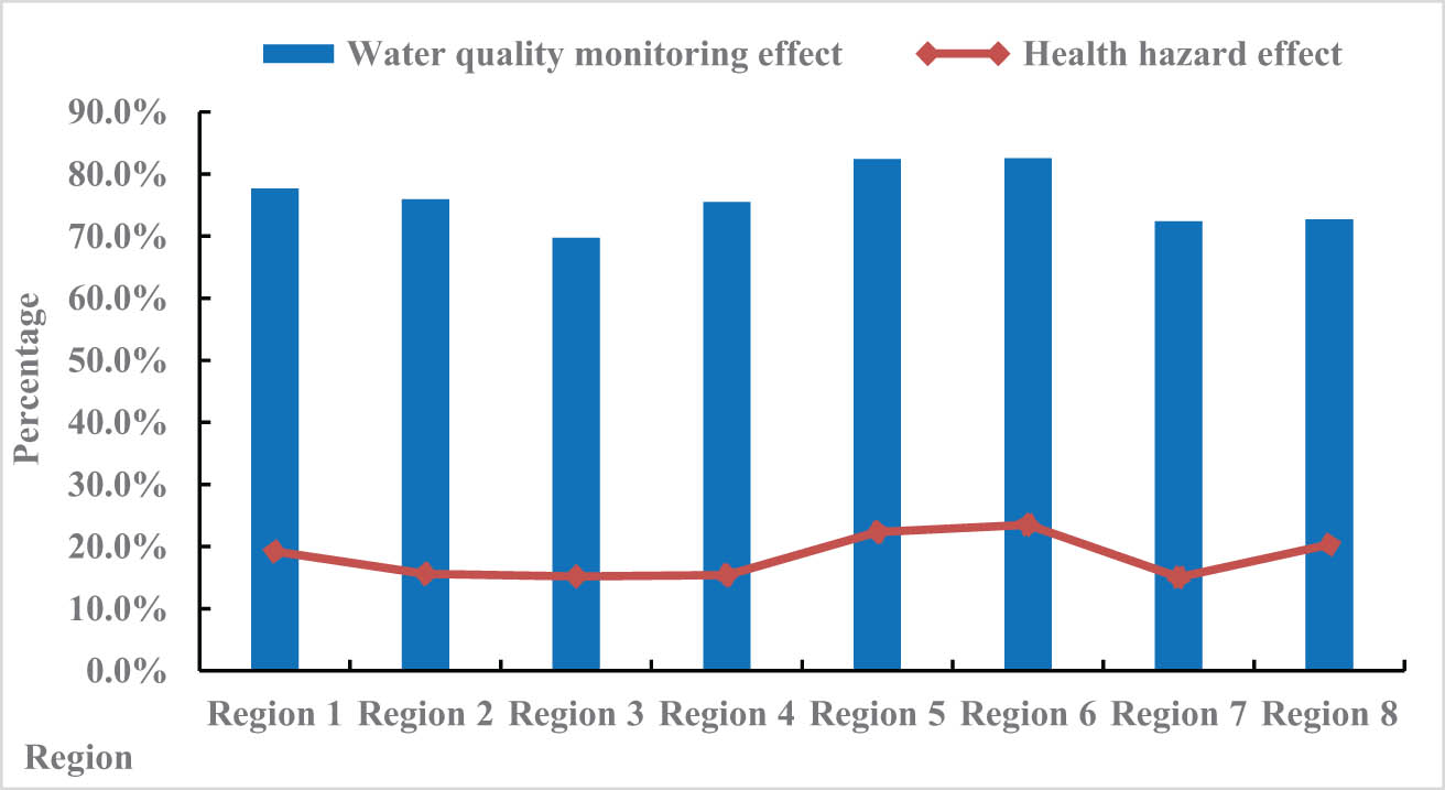
Effects of water quality monitoring and health hazards under the water environment health risk assessment system.
According to the data in Figure 3, among the surveyed regions, the water quality monitoring effect in Region 6 was the best, indicating that the region attached great importance to the quality of the water environment and the content and changes of substances, and the quality of its water quality can be better improve through the water environment health risk assessment system. In this survey, the health hazard effect of Region 7 was the lowest, indicating that the water quality in this area was less harmful to the human body. The main reason was that the content of toxic substances in water was lower than the normal standard.
Therefore, the harm to human body was relatively small. In addition, the water environmental health risk assessment system can clearly and quickly analyze the quality of water quality and the content of substances in water, timely extract their harmful substances, analyze the causes of their occurrence, and then reduce their content to reduce their harmful effects. Through this experimental analysis, it was found that the environmental health risk assessment system for urban water sources can improve the monitoring effect of water quality, regulate the way and development amount of urban water use, and reduce the harm of the water environment to human health to a certain extent. In addition, health risk assessment of the water environment can also help reduce the content of carcinogens in the water environment.
5 Application of fuzzy set theory in environmental health risk assessment of source water
To study the health risks of urban water sources, this article used fuzzy set theory to evaluate the health risks of urban water sources, analyzed the carcinogenic risks of single substances in the water sources, studied the relationship between water content and health, and calculated the cumulative carcinogenic risks in the water environment. The first step is to calculate the single substance carcinogenic risk in the water source environment as follows:
CI is the intake of pollutants per unit time and S is the carcinogenic factor of the pollutants. The relationship between water pollutants and health is analyzed as follows:
B is the concentration of pollutants in the water environment, X is the intake rate of drinking water; Y is the exposure frequency, F is the exposure period, D is the average body weight, and E is the average exposure time. Next, the cumulative carcinogenic risk of a single substance is calculated as follows:
i is the type of pollutant and T is the cumulative carcinogenic risk of a single substance. Later, the noncarcinogenic risk of a single substance is calculated as follows:
R is the reference value for carcinogenicity of the pollutant. Finally, the cumulative carcinogenic risk of multiple substances can be obtained as follows:
There are many substances harmful to the human body in the water environment, and even some substances contain carcinogenic factors, which can directly lead to cancer in human patients who drink water. Due to many uncertain factors in the water environment, it is important to assess the carcinogenic risk of carcinogens in the water environment. Therefore, this article also conducted a comprehensive assessment of the carcinogenic risk rate of substances before and after water environment treatment through the fuzzy set theory. Eight water areas were investigated, and the carcinogenic risk rates of substances in these water areas before and after water environment treatment were investigated for comprehensive assessment. The peak value of the carcinogenic risk rate of substances was 1, and the specific investigation results are shown in Figure 4.

Carcinogenic risk rate of substances before and after water environment optimization. (a) After water environment optimization and (b) before water environment optimization.
Figure 4a shows the cancer risk rate after water environment treatment, and Figure 4b shows the cancer risk rate before water environment treatment. The carcinogenic risk rate of substances in the water environment after treatment was significantly lower than before treatment. This indicated that the content of carcinogens in the water environment was relatively low after treatment, significantly reducing the content of carcinogens in water and reducing the harm to human body. It can be seen that the optimization of the water environment affected the carcinogenic risk rate of substances in water. After the optimization of the water environment, the content of carcinogens in water would significantly decrease, resulting in a decrease in the carcinogenic risk rate. If the water environment deteriorated, the content of carcinogens in its water would increase, and the risk of cancer would also increase. In addition, carcinogens in the water environment can also be reduced in their overall content through corresponding treatment measures, thereby reducing their harmfulness, improving the quality of water quality, and promoting the development of people’s health.
Overall, the water quality monitoring effect in traditional water environment health risk assessment is 74.2%, and the health hazard effect is 38.9%. The water quality monitoring effect in the new water environment health risk assessment is 81.5%, and the health hazard effect is 30.7%. Through comparison, it can be seen that the water quality monitoring effect in the new water environment health risk assessment is 7.3% higher than that in the traditional water environment health risk assessment, and the health hazard effect is 8.2% lower than that in the traditional water environment health risk assessment.
Through this experimental analysis, it was found that the urban water source environmental health risk assessment system can improve the monitoring effect of water quality, regulate the way and development amount of urban water use, and to some extent reduce the harm of water environment to human health. In addition, health risk assessment of the water environment can also help reduce the content of carcinogens in the water environment. In addition, the water source environmental risk assessment system based on fuzzy set theory can reduce harmful substances in the water environment, improve the quality of water sources, and provide guarantees for people’s safe drinking water. Moreover, the fuzzy set theory can quickly and efficiently evaluate the water source environment of various locations in cities, improve the management quality of water resources, and save manpower, material resources, and financial resources.
6 Countermeasures for environmental health protection of urban water sources based on fuzzy set theory
The management of urban water resource exploitation risks was carried out in the broader context of sustainable development. In other words, the risk management of urban water source development took into account both natural and human factors, that is, after the virtuous cycle of the natural ecosystem, it maintained a certain degree of balance to meet the needs of human development, but did not harm the aquatic ecosystem or pollute water quality.
6.1 Avoiding water pollution and waste
Preventing water pollution and waste is an effective measure to subjectively reduce development risks. With the rapid development of urban industry and agriculture, the demand for water and the resulting waste seriously pollute water resources, and the inefficient use of water resources leads to resource waste. The repair and reconstruction of the water pipe network can greatly improve the water delivery efficiency and reduce losses during the water delivery process. In addition, it can also expand the construction of wastewater treatment plants, improve wastewater treatment efficiency, expand the scope of wastewater treatment, improve wastewater treatment standards, and promote water recycling. Finally, sustainable utilization of water resources can be achieved. For some water sources that cannot be used as drinking water sources and whose health risks have exceeded the maximum acceptable range, it is recommended to implement poor quality groundwater treatment and reuse projects, using the treated water as industrial water, fire water, etc. For water supply wells that meet health risk requirements, measures such as pollution prevention and enhanced water supply treatment should be taken to reduce their impact on public health.
6.2 Relying on high-tech and new technologies
Advanced technologies need to be introduced to improve water efficiency, reduce pollutant emissions, and improve wastewater treatment. Industrial production must introduce advanced production technology, utilize intelligent control rather than manual control, maximize the use of water resources while avoiding the production of large amounts of pollutants, and also need to improve the production structure. In agriculture, advanced science and technology is used for irrigation to achieve a larger irrigation area under the same amount of water resources. To improve the speed of wastewater treatment, it is necessary to reduce the total amount of wastewater treatment while improving the daily wastewater treatment capacity. Guidelines and rules are proposed based on production methods and individual responsibilities.
6.3 Optimizing the risk management model for water resource development
Traditional risk management models for urban water resources development mainly focus on reducing and eliminating risks, but development risks can be reduced through risk transfer. To achieve the goal of water resource allocation, it is also necessary to formulate and improve water supply project planning, improve water supply capacity through technical measures, and ensure the demand for water for socio-economic development. Wastewater and mine water play an important role in regional water balance. Therefore, the focus is on waste construction and mine water reuse projects. In terms of policies and management, enterprises should be actively encouraged to utilize renewable water resources to improve the sustainability of water resources in the region. In terms of standards, it is necessary to provide generally accepted urban water source risk standards for enterprises and individuals, which would limit the development of water sources by enterprises. In a sense, the existing rules and policies are only formal and have no real deterrent effect. The recommendations on risk standards for urban water source development can serve as a basis for understanding the risk profile of urban water source development and formulating plans for urban water source development and use.
7 Conclusions
The concentration of industrial and agricultural production, as well as the growth of urban population, can lead to a rapid increase in water use, posing great harm to the urban water source and environment. Conducting health risk assessments on these important strategic resources will help to comprehensively understand urban water pollution and its impact on human health and the environment. The theme of this article is the environmental health risk assessment of urban water sources based on fuzzy set theory. First, a brief introduction was given to the relevant research background of the article. Then, the advantages and disadvantages of previous scholars’ research on water environment and health were summarized and analyzed. Then, the fuzzy set theory method was introduced to construct an environmental health risk assessment system for urban water sources and conduct evaluation and analysis. To verify the application effect of the fuzzy set theory method in urban water source environmental health risk assessment, this article also analyzed the water quality monitoring and health hazard effects in different regions. The results showed that the water source environmental risk assessment system based on the fuzzy set theory can reduce harmful substances in the water environment, improve water source quality, and provide guarantees for people’s safe drinking water. At the same time, it can also reduce the overall content of carcinogens in the water environment through corresponding treatment measures, reduce their harmfulness, improve water quality, and promote people’s healthy development, with practical application value.
-
Conflict of interest: Authors state no conflict of interest.
References
[1] Amarasiri M, Sano D, Suzuki S. Understanding human health risks caused by antibiotic resistant bacteria (ARB) and antibiotic resistance genes (ARG) in water environments: Current knowledge and questions to be answered. Crit Rev Environ Sci Technol. 2020;50:2016–59.10.1080/10643389.2019.1692611Search in Google Scholar
[2] D’Odorico P. The global value of water in agriculture. Proceedings of the National Academy of Sciences. Vol. 117. Issue 36. 2020. p. 21985–93.10.1073/pnas.2005835117Search in Google Scholar PubMed PubMed Central
[3] Arthington AH. Recent advances in environmental flows science and water management – innovation in the Anthropocene. Freshw Biol. 2018;63(8):1022–34.10.1111/fwb.13108Search in Google Scholar
[4] Rojas S, Horcajada P. Metal–organic frameworks for the removal of emerging organic contaminants in water. Chem Rev. 2020;120(16):8378–415.10.1021/acs.chemrev.9b00797Search in Google Scholar PubMed
[5] Lellis B. Effects of textile dyes on health and the environment and bioremediation potential of living organisms. Biotechnol Res Innov. 2019;3(2):275–90.10.1016/j.biori.2019.09.001Search in Google Scholar
[6] Zhang Q, Xu EG, Li J, Chen Q, Ma L, Zeng EY, Shi H. A review of microplastics in table salt, drinking water, and air: direct human exposure. Environ Sci Technol. 2020;54:3740–51.10.1021/acs.est.9b04535Search in Google Scholar PubMed
[7] Mauter MS, Zucker I, Perreault F, Werber JR, Kim JH, Elimelech M. The role of nanotechnology in tackling global water challenges. Nat Sustainability. 2018;14:166–75.10.1038/s41893-018-0046-8Search in Google Scholar
[8] Narsimha A, Rajitha S. Spatial distribution and seasonal variation in fluoride enrichment in groundwater and its associated human health risk assessment in Telangana State, South India. Hum Ecol Risk Ass An Int J. 2018;24(8):2119–32.10.1080/10807039.2018.1438176Search in Google Scholar
[9] Obasi PN, Akudinobi BB. Potential health risk and levels of heavy metals in water resources of lead–zinc mining communities of Abakaliki, southeast Nigeria. Appl Water Sci. 2020;10(7):1–23.10.1007/s13201-020-01233-zSearch in Google Scholar
[10] Cordner A, De La Rosa VY, Schaider LA, Rudel RA, Richter L, Brown P. Guideline levels for PFOA and PFOS in drinking water: the role of scientific uncertainty, risk assessment decisions, and social factors. J Exposure Sci Environ Epidemiol. 2019;29(2):157–71.10.1038/s41370-018-0099-9Search in Google Scholar PubMed PubMed Central
[11] Chalchisa D, Megersa M, Beyene A. Assessment of the quality of drinking water in storage tanks and its implication on the safety of urban water supply in developing countries.” Environ Syst Res. 2018;6(1):1–6.10.1186/s40068-017-0089-2Search in Google Scholar
[12] Li P, He X, Li Y, Xiang G. Occurrence and health implication of fluoride in groundwater of loess aquifer in the Chinese loess plateau: a case study of Tongchuan, Northwest China. Exposure Health. 2019;11(2):95–107.10.1007/s12403-018-0278-xSearch in Google Scholar
[13] Richardson SD, Ternes TA. Water analysis: emerging contaminants and current issues. Anal Chem. 2018;90(1):398–428.10.1021/acs.analchem.7b04577Search in Google Scholar PubMed
[14] Ahn J. Construction of urban water source circulating water pollution prevention system based on semi-supervised learning and bayesian algorithm. Water Pollut Prev Control Proj. 2021;2(2):22–32.10.38007/WPPCP.2021.020203Search in Google Scholar
[15] Alimi OS. Microplastics and nanoplastics in aquatic environments: aggregation, deposition, and enhanced contaminant transport. Environ Sci Technol. 2018;52(4):1704–24.10.1021/acs.est.7b05559Search in Google Scholar PubMed
[16] Ramya S. Plastic industry development and natural environment protection. Nat Environ Prot. 2020;1(2):38–46.10.38007/NEP.2020.010205Search in Google Scholar
[17] Pan Y. Worldwide distribution of novel perfluoroether carboxylic and sulfonic acids in surface water. Environ Sci Technol. 2018;52(14):7621–9.10.1021/acs.est.8b00829Search in Google Scholar PubMed
[18] Unver S, Ergenc I. Safety risk identification and prioritize of forest logging activities using analytic hierarchy process (AHP). Alex Eng J. 2021;60(1):1591–9.10.1016/j.aej.2020.11.012Search in Google Scholar
[19] Khan A, Qu X, Madzikanda B. An exploratory study on risk identification of cross‐boundary innovation of manufacturing enterprises based on grounded theory. Creativity Innov Manag. 2022;31(3):492–508.10.1111/caim.12501Search in Google Scholar
[20] El-Sayegh SM, Manjikian S, Ibrahim A, Abouelyousr A, Jabbour R. Risk identification and assessment in sustainable construction projects in the UAE. Int J Constr Manag. 2021;21(4):327–36.10.1080/15623599.2018.1536963Search in Google Scholar
[21] Jasiulewicz-Kaczmarek M, Żywica P, Gola A. Fuzzy set theory driven maintenance sustainability performance assessment model: A multiple criteria approach. J Intell Manuf. 2021;32:1497–515.10.1007/s10845-020-01734-3Search in Google Scholar
[22] Muhammad S, Ahmad MR, Rahman AU. Refined pythagorean fuzzy sets: properties, set-theoretic operations and axiomatic results. J Comput Cognit Eng. 2023;2(1):10–6.Search in Google Scholar
[23] Jabeer N. BIOFOR Biological aerated filter in environmental biology. Acad J Environ Biol. 2020;1(1):1–9.10.38007/AJEB.2020.010101Search in Google Scholar
© 2023 the author(s), published by De Gruyter
This work is licensed under the Creative Commons Attribution 4.0 International License.
Articles in the same Issue
- Regular Articles
- Diagenesis and evolution of deep tight reservoirs: A case study of the fourth member of Shahejie Formation (cg: 50.4-42 Ma) in Bozhong Sag
- Petrography and mineralogy of the Oligocene flysch in Ionian Zone, Albania: Implications for the evolution of sediment provenance and paleoenvironment
- Biostratigraphy of the Late Campanian–Maastrichtian of the Duwi Basin, Red Sea, Egypt
- Structural deformation and its implication for hydrocarbon accumulation in the Wuxia fault belt, northwestern Junggar basin, China
- Carbonate texture identification using multi-layer perceptron neural network
- Metallogenic model of the Hongqiling Cu–Ni sulfide intrusions, Central Asian Orogenic Belt: Insight from long-period magnetotellurics
- Assessments of recent Global Geopotential Models based on GPS/levelling and gravity data along coastal zones of Egypt
- Accuracy assessment and improvement of SRTM, ASTER, FABDEM, and MERIT DEMs by polynomial and optimization algorithm: A case study (Khuzestan Province, Iran)
- Uncertainty assessment of 3D geological models based on spatial diffusion and merging model
- Evaluation of dynamic behavior of varved clays from the Warsaw ice-dammed lake, Poland
- Impact of AMSU-A and MHS radiances assimilation on Typhoon Megi (2016) forecasting
- Contribution to the building of a weather information service for solar panel cleaning operations at Diass plant (Senegal, Western Sahel)
- Measuring spatiotemporal accessibility to healthcare with multimodal transport modes in the dynamic traffic environment
- Mathematical model for conversion of groundwater flow from confined to unconfined aquifers with power law processes
- NSP variation on SWAT with high-resolution data: A case study
- Reconstruction of paleoglacial equilibrium-line altitudes during the Last Glacial Maximum in the Diancang Massif, Northwest Yunnan Province, China
- A prediction model for Xiangyang Neolithic sites based on a random forest algorithm
- Determining the long-term impact area of coastal thermal discharge based on a harmonic model of sea surface temperature
- Origin of block accumulations based on the near-surface geophysics
- Investigating the limestone quarries as geoheritage sites: Case of Mardin ancient quarry
- Population genetics and pedigree geography of Trionychia japonica in the four mountains of Henan Province and the Taihang Mountains
- Performance audit evaluation of marine development projects based on SPA and BP neural network model
- Study on the Early Cretaceous fluvial-desert sedimentary paleogeography in the Northwest of Ordos Basin
- Detecting window line using an improved stacked hourglass network based on new real-world building façade dataset
- Automated identification and mapping of geological folds in cross sections
- Silicate and carbonate mixed shelf formation and its controlling factors, a case study from the Cambrian Canglangpu formation in Sichuan basin, China
- Ground penetrating radar and magnetic gradient distribution approach for subsurface investigation of solution pipes in post-glacial settings
- Research on pore structures of fine-grained carbonate reservoirs and their influence on waterflood development
- Risk assessment of rain-induced debris flow in the lower reaches of Yajiang River based on GIS and CF coupling models
- Multifractal analysis of temporal and spatial characteristics of earthquakes in Eurasian seismic belt
- Surface deformation and damage of 2022 (M 6.8) Luding earthquake in China and its tectonic implications
- Differential analysis of landscape patterns of land cover products in tropical marine climate zones – A case study in Malaysia
- DEM-based analysis of tectonic geomorphologic characteristics and tectonic activity intensity of the Dabanghe River Basin in South China Karst
- Distribution, pollution levels, and health risk assessment of heavy metals in groundwater in the main pepper production area of China
- Study on soil quality effect of reconstructing by Pisha sandstone and sand soil
- Understanding the characteristics of loess strata and quaternary climate changes in Luochuan, Shaanxi Province, China, through core analysis
- Dynamic variation of groundwater level and its influencing factors in typical oasis irrigated areas in Northwest China
- Creating digital maps for geotechnical characteristics of soil based on GIS technology and remote sensing
- Changes in the course of constant loading consolidation in soil with modeled granulometric composition contaminated with petroleum substances
- Correlation between the deformation of mineral crystal structures and fault activity: A case study of the Yingxiu-Beichuan fault and the Milin fault
- Cognitive characteristics of the Qiang religious culture and its influencing factors in Southwest China
- Spatiotemporal variation characteristics analysis of infrastructure iron stock in China based on nighttime light data
- Interpretation of aeromagnetic and remote sensing data of Auchi and Idah sheets of the Benin-arm Anambra basin: Implication of mineral resources
- Building element recognition with MTL-AINet considering view perspectives
- Characteristics of the present crustal deformation in the Tibetan Plateau and its relationship with strong earthquakes
- Influence of fractures in tight sandstone oil reservoir on hydrocarbon accumulation: A case study of Yanchang Formation in southeastern Ordos Basin
- Nutrient assessment and land reclamation in the Loess hills and Gulch region in the context of gully control
- Handling imbalanced data in supervised machine learning for lithological mapping using remote sensing and airborne geophysical data
- Spatial variation of soil nutrients and evaluation of cultivated land quality based on field scale
- Lignin analysis of sediments from around 2,000 to 1,000 years ago (Jiulong River estuary, southeast China)
- Assessing OpenStreetMap roads fitness-for-use for disaster risk assessment in developing countries: The case of Burundi
- Transforming text into knowledge graph: Extracting and structuring information from spatial development plans
- A symmetrical exponential model of soil temperature in temperate steppe regions of China
- A landslide susceptibility assessment method based on auto-encoder improved deep belief network
- Numerical simulation analysis of ecological monitoring of small reservoir dam based on maximum entropy algorithm
- Morphometry of the cold-climate Bory Stobrawskie Dune Field (SW Poland): Evidence for multi-phase Lateglacial aeolian activity within the European Sand Belt
- Adopting a new approach for finding missing people using GIS techniques: A case study in Saudi Arabia’s desert area
- Geological earthquake simulations generated by kinematic heterogeneous energy-based method: Self-arrested ruptures and asperity criterion
- Semi-automated classification of layered rock slopes using digital elevation model and geological map
- Geochemical characteristics of arc fractionated I-type granitoids of eastern Tak Batholith, Thailand
- Lithology classification of igneous rocks using C-band and L-band dual-polarization SAR data
- Analysis of artificial intelligence approaches to predict the wall deflection induced by deep excavation
- Evaluation of the current in situ stress in the middle Permian Maokou Formation in the Longnüsi area of the central Sichuan Basin, China
- Utilizing microresistivity image logs to recognize conglomeratic channel architectural elements of Baikouquan Formation in slope of Mahu Sag
- Resistivity cutoff of low-resistivity and low-contrast pays in sandstone reservoirs from conventional well logs: A case of Paleogene Enping Formation in A-Oilfield, Pearl River Mouth Basin, South China Sea
- Examining the evacuation routes of the sister village program by using the ant colony optimization algorithm
- Spatial objects classification using machine learning and spatial walk algorithm
- Study on the stabilization mechanism of aeolian sandy soil formation by adding a natural soft rock
- Bump feature detection of the road surface based on the Bi-LSTM
- The origin and evolution of the ore-forming fluids at the Manondo-Choma gold prospect, Kirk range, southern Malawi
- A retrieval model of surface geochemistry composition based on remotely sensed data
- Exploring the spatial dynamics of cultural facilities based on multi-source data: A case study of Nanjing’s art institutions
- Study of pore-throat structure characteristics and fluid mobility of Chang 7 tight sandstone reservoir in Jiyuan area, Ordos Basin
- Study of fracturing fluid re-discharge based on percolation experiments and sampling tests – An example of Fuling shale gas Jiangdong block, China
- Impacts of marine cloud brightening scheme on climatic extremes in the Tibetan Plateau
- Ecological protection on the West Coast of Taiwan Strait under economic zone construction: A case study of land use in Yueqing
- The time-dependent deformation and damage constitutive model of rock based on dynamic disturbance tests
- Evaluation of spatial form of rural ecological landscape and vulnerability of water ecological environment based on analytic hierarchy process
- Fingerprint of magma mixture in the leucogranites: Spectroscopic and petrochemical approach, Kalebalta-Central Anatolia, Türkiye
- Principles of self-calibration and visual effects for digital camera distortion
- UAV-based doline mapping in Brazilian karst: A cave heritage protection reconnaissance
- Evaluation and low carbon ecological urban–rural planning and construction based on energy planning mechanism
- Modified non-local means: A novel denoising approach to process gravity field data
- A novel travel route planning method based on an ant colony optimization algorithm
- Effect of time-variant NDVI on landside susceptibility: A case study in Quang Ngai province, Vietnam
- Regional tectonic uplift indicated by geomorphological parameters in the Bahe River Basin, central China
- Computer information technology-based green excavation of tunnels in complex strata and technical decision of deformation control
- Spatial evolution of coastal environmental enterprises: An exploration of driving factors in Jiangsu Province
- A comparative assessment and geospatial simulation of three hydrological models in urban basins
- Aquaculture industry under the blue transformation in Jiangsu, China: Structure evolution and spatial agglomeration
- Quantitative and qualitative interpretation of community partitions by map overlaying and calculating the distribution of related geographical features
- Numerical investigation of gravity-grouted soil-nail pullout capacity in sand
- Analysis of heavy pollution weather in Shenyang City and numerical simulation of main pollutants
- Road cut slope stability analysis for static and dynamic (pseudo-static analysis) loading conditions
- Forest biomass assessment combining field inventorying and remote sensing data
- Late Jurassic Haobugao granites from the southern Great Xing’an Range, NE China: Implications for postcollision extension of the Mongol–Okhotsk Ocean
- Petrogenesis of the Sukadana Basalt based on petrology and whole rock geochemistry, Lampung, Indonesia: Geodynamic significances
- Numerical study on the group wall effect of nodular diaphragm wall foundation in high-rise buildings
- Water resources utilization and tourism environment assessment based on water footprint
- Geochemical evaluation of the carbonaceous shale associated with the Permian Mikambeni Formation of the Tuli Basin for potential gas generation, South Africa
- Detection and characterization of lineaments using gravity data in the south-west Cameroon zone: Hydrogeological implications
- Study on spatial pattern of tourism landscape resources in county cities of Yangtze River Economic Belt
- The effect of weathering on drillability of dolomites
- Noise masking of near-surface scattering (heterogeneities) on subsurface seismic reflectivity
- Query optimization-oriented lateral expansion method of distributed geological borehole database
- Petrogenesis of the Morobe Granodiorite and their shoshonitic mafic microgranular enclaves in Maramuni arc, Papua New Guinea
- Environmental health risk assessment of urban water sources based on fuzzy set theory
- Spatial distribution of urban basic education resources in Shanghai: Accessibility and supply-demand matching evaluation
- Spatiotemporal changes in land use and residential satisfaction in the Huai River-Gaoyou Lake Rim area
- Walkaway vertical seismic profiling first-arrival traveltime tomography with velocity structure constraints
- Study on the evaluation system and risk factor traceability of receiving water body
- Predicting copper-polymetallic deposits in Kalatag using the weight of evidence model and novel data sources
- Temporal dynamics of green urban areas in Romania. A comparison between spatial and statistical data
- Passenger flow forecast of tourist attraction based on MACBL in LBS big data environment
- Varying particle size selectivity of soil erosion along a cultivated catena
- Relationship between annual soil erosion and surface runoff in Wadi Hanifa sub-basins
- Influence of nappe structure on the Carboniferous volcanic reservoir in the middle of the Hongche Fault Zone, Junggar Basin, China
- Dynamic analysis of MSE wall subjected to surface vibration loading
- Pre-collisional architecture of the European distal margin: Inferences from the high-pressure continental units of central Corsica (France)
- The interrelation of natural diversity with tourism in Kosovo
- Assessment of geosites as a basis for geotourism development: A case study of the Toplica District, Serbia
- IG-YOLOv5-based underwater biological recognition and detection for marine protection
- Monitoring drought dynamics using remote sensing-based combined drought index in Ergene Basin, Türkiye
- Review Articles
- The actual state of the geodetic and cartographic resources and legislation in Poland
- Evaluation studies of the new mining projects
- Comparison and significance of grain size parameters of the Menyuan loess calculated using different methods
- Scientometric analysis of flood forecasting for Asia region and discussion on machine learning methods
- Rainfall-induced transportation embankment failure: A review
- Rapid Communication
- Branch fault discovered in Tangshan fault zone on the Kaiping-Guye boundary, North China
- Technical Note
- Introducing an intelligent multi-level retrieval method for mineral resource potential evaluation result data
- Erratum
- Erratum to “Forest cover assessment using remote-sensing techniques in Crete Island, Greece”
- Addendum
- The relationship between heat flow and seismicity in global tectonically active zones
- Commentary
- Improved entropy weight methods and their comparisons in evaluating the high-quality development of Qinghai, China
- Special Issue: Geoethics 2022 - Part II
- Loess and geotourism potential of the Braničevo District (NE Serbia): From overexploitation to paleoclimate interpretation