Impacts of marine cloud brightening scheme on climatic extremes in the Tibetan Plateau
-
Zhihua Zhang
 ,
Yuanzhuo Zhu
,
Yuanzhuo Zhu

Abstract
As an ecologically fragile plateau and major water source in Asia, the Tibetan Plateau (TP) has grown warmer over recent decades, contributing to frequent occurrence of extreme climate events. It is urgently needed to find a suitable option to mitigate climate change impacts in the TP. The marine cloud brightening (MCB) scheme is proposed to mitigate global warming through the increasing cloud droplet number concentration of low marine clouds to reflect some solar radiation back into space. Until now, impacts of MCB scheme on the TP have not been investigated. In this study, we utilized 13 Expert Team on Climate Change Detection and Indices to assess the evolution of climate extremes over the TP with/without MCB implementation. We found that although the MCB is implemented over ocean only, it would cause significant changes on climate extremes in the TP which is very far from oceans and much higher than sea level. During 2030–2059, MCB implementation can decrease warm temperature extremes, leading to a significant decrease in the TXx index by 6–18°C, the TX90p index by 15–45 days, and the TN90p index by 15–50 days. MCB implementation would also have some cooling effects on cold temperature extremes, leading to an increase in the ID index by 30–80 days, the TX10p index by 22–32 days, and the TN10p index by about 12 days and a decrease in the TNn index by 0.5–1.5°C. Although MCB implementation would not have much impacts on precipitation extremes, it would significantly increase the area of the region with <10% drought frequency, and increase the drought intensity in the west of Lhasa city.
1 Introduction
Global warming is one of the greatest threats to human survival [1] and seriously restricts the achievement of UN sustainable development goals [2], especially for developing countries [3]. The main factor causing global warming is the increase in global carbon emissions [4]. In March 2021, the concentration of carbon dioxide in the atmosphere reached more than 417 ppm at the Mauna Loa Observatory in Hawaii while the pre-industrial level was just about 278 ppm. The past 7 years (2015–2021) are on track to be the seven warmest on record [5]. Further warming of the Earth’s system would increase the frequency and intensity of extreme climate events, leading to significantly negative impacts on many vulnerable aspects of human health, social organization, and natural systems [6,7,8,9].
In order to mitigate climate change, the marine cloud brightening (MCB) scheme, which is designed to reflect a small amount of solar radiation back into space by increasing the cloud albedo, has been proposed [10]. It can be implemented in practice by adding suitable cloud condensation nuclei (e.g., sea salt) into the tropic marine boundary layer, leading to the enhancement of the cloud droplet number concentration (CDNC) and the reduction in the droplet sizes. MCB implementation would cause a global significant temperature decrease with strong cooling over low-latitude continents [11]; meanwhile, the global mean precipitation would decrease by about 1.3%, and runoff over land would increase by 7.5% especially over tropical land [12]; especially, a significant drying would occur in the Amazon basin [13]. The added particles must be small enough to avoid increase in the precipitation, but large enough to activate into cloud droplets [14]. Based on simulation of three climate models (NorESM1-M, GISS-E2-R, and HadGEM2-ES), MCB scheme would increase the CNDC in lower layers, reduce the cloud-top effective droplet radius, and increase the cloud optical depth over the injection area [15]. Horowitz et al. [16] revealed that MCB implement can lead to changes in global tropospheric ozone (−3 to −6%) and methine lifetime (+3 to 6%). By running geophysical fluid dynamics laboratory model to simulate MCB scheme, Mahfouz et al. [17] revealed the perturbations in the tropics would lead to significant changes outside the tropics. Existing research mainly focused on global-scale impacts of MCB schemes, while region-scale impacts were analyzed very limitedly. Latham et al. [18] found by utilizing HadGEM1 model that MCB could significantly reduce sea surface temperatures in regions where hurricanes develop, leading to the weakening of hurricanes. Zhu et al. [19] recommended to consider MCB scheme as a potential emergency shield to catastrophic climate extremes and resulting disasters in Sahara-Sahel-Arabian Peninsula zone. Goddard et al. [20] indicated that MCB could cool the waters in the Gulf of Mexico and then reduce hurricane strength and benefit local coral reefs.
The Tibetan Plateau (TP) is situated in one of Earth’s extreme continental climate settings and is influenced by numerous climatic regimes such as the East Asian and Indian monsoons and westerlies [21]. As an ecologically fragile region with the highest altitude, the TP has grown warmer and wetter over recent decades, contributing to the occurrence of extreme climate events [22]. In most regions of the TP, almost all warm extreme indices display significant increasing trends and most of the cold extreme indices show significant decreasing trends during 1961–2016 [22]. The number of frost days is predicted to decrease and the frequency of warm nights increase over the TP in the twenty-first century, while heavy precipitation events are projected to increase in their intensity over most parts of the TP [23]. As global warming continues, it is predicted that the climate of the TP will break the balance of the past, while the frequency and intensity of extreme climate events would increase significantly, leading to serious impacts on the ecological environment, agricultural production, and social economy [24]. It is urgently needed to find a suitable option to mitigate climate change impacts in the TP.
The impacts of MCB scheme demonstrate significant regional differences: some countries and regions would gain from MCB scheme considerably, whereas others might be faced with a worse set of circumstances than would be the case without MCB [25]. The TP plays a crucial role in the provision of water resources to most of the Asian continent, both directly via the large rivers that originate there and also via the temperature contrast between the TP and the Ocean, which is an important controlling factor for both the Asian monsoon and global atmospheric circulation patterns. MCB implementation would not only affect the TP itself, but also have a profound impact on East and South Asia. Until now, impacts of MCB scheme on the TP have not been investigated. Therefore, in this study, we will quantify impacts of the MCB scheme on mitigating the increasing trend of climate extremes in the TP.
2 Study area
The TP, with an average elevation of over 4,000 m and an area of approximately 2.5 × 10⁶ km2, is the highest and most extensive highland in the world [26]. Its environment is characterized as a high-altitude arid steppe interspersed with mountain ranges and large lakes and exerts a huge influence on regional-scale and global-scale climate through the temperature contrast between the TP and the Oceans [27]. Due to its strong sensitivity to climate change, the TP is considered as one of the most vulnerable ecosystems. The total annual solar radiation is 140–180 kcal/cm2 and the total annual sunshine hours can reach 2,500–3,200 h. The annual average temperature in the TP decreases from 20°C in the southeast to below −6°C in the northwest. Since the warm and humid air currents in the southern-ocean are blocked by multiple high mountains, the annual average precipitation in the TP reduces from 2,000 mm to below 50 mm.
3 Data and methods
The main factor causing global warming is the increase in the anthropogenic carbon emissions. The widely used Representative Concentration Pathway (RCP) scenarios describe plausible future trajectories of atmospheric carbon dioxide concentration conditions. These RCP scenarios for climate change research are not forecasts or predictions, but reflect expert judgments regarding plausible future emissions [28]. The RCP4.5 is the middle-of-the-road carbon emissions scenario and assumes continued anthropogenic carbon emissions increasing from today’s level, followed by a decrease from the year 2040 and stabilization by the year 2100, at which time the anthropogenic radiative forcing amounts to 4.5 W/m2 over pre-industrial level [29]. By inputting RCP scenarios into climate models, researchers can evaluate trends of future climate change under difference carbon emission trajectories and reveal implications of different mitigation and adaption approaches.
3.1 Simulated data of MCB scheme
Due to possible side effects and huge amount of implement costs, the MCB scheme cannot be implemented directly in the real world, so various climate models are used to simulate MCB scheme and reveal its impacts, efficiency, and side effects. In the known GeoMIP experiments, the G4cdnc experiment dealt with MCB scheme, and it was designed to simulate an increase in the CDNC of the global marine lower clouds by 50% under the RCP4.5 scenario from 2020 to 2069 [14,30]. Output data of G4cdnc experiment running by different climate models were stored in the portals of Earth System Grid Federation (ESGF) (e.g., https://esgf-node.llnl.gov/). Only three climate models (HadGEM2-ES, MIROC-ESM, and CSIRO-Mk3L-1-2) (Table 1) provided simulated daily temperature and precipitation data in the output of G4cdnc experiment in ESGF portals.
Climate models used in this study
| Model | Institution | Resolution (lon × lat level) |
|---|---|---|
| HadGEM2-ES | Met Office Hadley Centre, UK | 1.875° × 1.25° |
| MIROC-ESM | AORI, NIES, JAMSTEC, Japan | 2.8° × 2.8° |
| CSIRO-Mk3L-1-2 | UNSW, Sydney, Australia | 5.625° × 3.18° |
Since these climate models have different spatial resolutions, in order to calculate the multi-model ensemble mean, all the simulation data from three climate models were interpolated to a grid resolution of 1° longitude
3.2 Extreme climate indices
In this study, we used the ensemble mean of simulation data of the G4cdnc experiment by three climate models to examine evolution of climatic extreme events in the TP with/without MCB implementation. 13 climate indices (Table 2) defined by the Expert Team on Climate Change Detection and Indices (ETCCDI) [31] were utilized to comprehensively assess the temperature and precipitation extremes from 2030 to 2059 in the TP with/without MCB. We calculated 13 extreme indices in the TP under the two scenarios (RCP4.5 and MCB) during 2030–2059.
Definition of climate extreme indices
| Category | Index | Description | Definition | Unit |
|---|---|---|---|---|
| Warm temperature extremes | SU | Summer days | Annual number of days when TX (daily maximum) >25°C | Days |
| TXx | Highest Tmax | Annual maximum value of daily maximum temperature | °C | |
| TNx | Highest Tmin | Annual maximum value of daily minimum temperature | °C | |
| TX90p | Warm days | Number of days when TX (daily maximum) >90th percentile for historical 1970–1999 | Days | |
| TN90p | Warm nights | Number of days when TN (daily minimum) >90th percentile for historical 1970–1999 | Days | |
| Cold temperature extremes | ID | Ice days | Annual number of days when TX (daily maximum) <0°C | Days |
| TXn | Lowest Tmax | Annual minimum value of daily maximum temperature | °C | |
| TNn | Lowest Tmin | Annual minimum value of daily minimum temperature | °C | |
| TX10p | Cold days | Number of days when TX (daily maximum) <10th percentile for historical 1970–1999 | Days | |
| TN10p | Cold nights | Number of days when TN (daily minimum) <10th percentile for historical 1970–1999 | Days | |
| Precipitation extremes | CDD | Consecutive dry days | Maximum number of consecutive days when precipitation <1 mm | Days |
| CWD | Consecutive wet days | Maximum number of consecutive days when precipitation ≥1 mm | Days | |
| Rx5day | Wettest consecutive five days | Maximum of consecutive 5 days (cumulative) precipitation amount | mm |
TX: maximum temperature, TN: minimum temperature.
3.3 Standardized precipitation index (SPI)
The SPI is a drought index to measure the deficiency of precipitation on various monthly and multi-monthly time scales relative to its climatology [32]. On short timescales, the SPI is closely related to soil moisture, while at longer timescales, the SPI is related to groundwater and reservoir storage.
The Gamma distribution is used in SPI to calculate the probability distribution of precipitation time series. Its probability density function is defined as follows:
where
where
The inverse normal function, with mean zero and variance one, is applied to this cumulative probability, i.e., one finds a value
Then, the SPI value for precipitation
Drought classification
| SPI values | Categorization |
|---|---|
| SPI
|
Extremely dry |
| −2.0 < SPI
|
Moderately dry |
| −1.5 < SPI
|
Dry |
| −1.0 < SPI < 1.0 | Neutral |
| 1.0
|
Wet |
| 1.5
|
Moderately wet |
| 2.0
|
Extremely wet |
3.4 Mann–Kendall (MK) trend test and a Sen’s slope estimator
To reveal evolution and mitigation of climate extreme events with/without MCB schemes, we used the combination of a nonparametric MK trend test and a Sen’s slope estimator to determine intensities and significance of temperature and precipitation extremes.
The MK test is to statistically assess whether a time series
where
If data are independent and randomly ordered, then
Sens’ slope estimator can be used to discover trends in a time series. It is superior to the linear regression since it is not affected by the number of outliers and data errors. For a time series
Sen’s slope of the whole time series
4 Results
Although the MCB scheme can act rapidly to mitigate climate change with significant global mean temperature decreases [11], the benefits of MCB are likely to be widely varying spatially over the planet. Based on the ensemble mean of three climate models (HadGEM2-ES, MIROC-ESM, and CSIRO-Mk3L-1-2), we quantified impacts of the MCB scheme on mitigating the increasing trend of climate extremes in the TP.
4.1 Warm temperature extremes
Regardless of MCB’s intervention, the mean annual SU index (summer days) during 2030–2059 would reach 70 days only in the northern/southern edge of the plateau (Figure 1). With the increase in altitude, the SU index would quickly decrease to 0–10 days in the plateau interior. Under the RCP4.5 scenario, the mean annual TXx index (maximum temperature) would be >5°C in the whole plateau and even reach 30°C at northern and southeastern edges (Figure 1). Under MCB implementation, the intensity of TXx was <0°C in the plateau interior and <20°C in almost the whole plateau (Figure 1). The cooling effects of MCB on TXx was significant, the decrease in TXx index would be 6–18°C. However, the MCB did not demonstrate evident cooling effects on TNx, the difference in TNx under two scenarios ranged from −2 to 4°C. The TX90p index (warm days) would be from 80 to 120 days under the RCP4.5 scenario, while it ranged from 50 to 80 days under MCB implementation (Figure 1). During 2030–2059, the mean annual TN90p index (warm nights) was predicted to be 100–140 days under RCP4.5 and 60–80 days under MCB implementation. Therefore, the MCB implementation demonstrated significant cooling effects on warm days/nights indices (TX90p, TN90p).

Mean annual warm temperature extreme indices during 2030–2059 under RCP4.5 scenario, MCB scenario, and their difference.
Under the RCP4.5 scenario, the SU index (summer days) was predicted to have a significant increasing trend in the northern edge (>4 days/decade) and southeast (∼0.8 days/decade) of the plateau during 2030–2059 and have significant decreasing trends (−3.8 days/decade) in the northern plateau interior (Figure 2). Under MCB implementation, the SU index was predicted to significantly decrease in the Himalayan region (about 1.6 days/decade). Compared with the RCP4.5 scenario, MCB implementation could significantly mitigate the decreasing trend rate of SU index in the northern plateau interior (>4.5 days/decade) (Figure 2). The northern plateau interior, which is also referred to as Qiangtang grassland, is one of the five largest pastures and an ideal living area for rare animals in China. Since the northern plateau is cold, windy, and snowy for 8 or 9 months a year, mitigation of the decreasing trend rate of SU index through MCB implementation is crucial for environmental protection, biodiversity, and ecological restoration in Qiangtang grassland.

Trend of annual warm temperature extreme indices under the RCP4.5 scenario, MCB scenario and their difference during 2030–2059, where stippling indicates statistically significant trends at α = 0.05.
Under the RCP4.5 scenario, the TXx index would show statistically significant increasing trends only in the northwest and southeast edges of the TP (2.8–3.2°C/decade). Under MCB implementation, the TXx index would show statistically significant trends only in some of the western part of the plateau interior (∼0.8°C/decade). Compared with the RCP4.5 scenario, MCB implementation could weaken slightly increasing trends in the southeast plateau but strengthen slightly increasing trends in the plateau interior (Figure 2). For the TNx index, MCB implementation could weaken cooling trends in the whole TP except for southeastern edge, but this trend is not statistically significant (Figure 2).
Under either the RCP4.5 scenario or the MCB implementation scenario, increasing trends in TX90p and TN90p indices in the whole TP would be statistically significant at the level α = 0.05 (Figure 2). Compared with the RCP4.5 scenario, MCB implementation could mitigate the increasing trend of the TX90p index over almost the whole plateau and the increasing trend of the TN90p index in the eastern plateau (∼0–9 days/decade).
4.2 Cold temperature extremes
Under the RCP4.5 scenario, the mean annual ID index (ice days) over the TP during 2030–2059 was predicted to range from about 60 days on the plateau periphery to 300 days in the plateau interior (Figure 3). Although the spatial pattern of the ID index under the MCB implementation scenario was very similar to an RCP4.5 scenario, it demonstrated the cooling effect on the whole TP, i.e., the ID index would decrease 30 days in the plateau interior and 80 days in the plateau periphery. The MCB implementation would be expected to have warming effects on mean annual TXn index (lowest Tmax) by 2–8°C during 2030–2059, especially the maximal increase would occur in the plateau interior (Figure 3). For the TNn index, when compared with RCP4.5 scenario, MCB implementation would decrease TNn by 0.5–1.5°C. Under the RCP4.5 scenario, the mean annual TX10p index (cold days) during 2030–2059 would range from ∼10 days in the northeast to ∼20 days in the southwest. MCB implementation would increase the TX10p index over the whole plateau and range from ∼32 days on the southern plateau to ∼22 days on the northern plateau. For the mean annual TN10p index (cold nights) under both RCP4.5 and MCB scenarios, its spatial patterns would have no significant regional difference. MCB implementation would increase the mean annual TN10p index by about 12 days when compared with the RCP4.5 scenario (Figure 3).

Mean annual cold temperature extreme indices during 2030–2059 under the RCP4.5 scenario, MCB scenario, and their difference.
During 2030–2059, the ID index under the RCP4.5 scenario would show a significant decreasing trend over most of the plateau, ranging from −1.5 to −5 days/decade; especially, maximal warming trends would occur in the southeast plateau (Figure 4). Under MCB implementation, the ID index showed significant decreasing trends with −0.5 to −3.5 days/decade in the eastern and northern plateau, but the ID index in southwest region had no significant change. MCB implementation would mitigate the severe decreasing trends of the ID index except for the northern periphery of the plateau when compared with the RCP4.5 scenario (Figure 4).

Trend of annual cold temperature extreme indices under the RCP4.5 scenario, MCB scenario, and their difference during 2030–2059, where stippling indicates statistically significant trends at α = 0.05.
Under the RCP4.5 scenario, the TXn index (Lowest Tmax) would show statistically significant increasing trends with about 0.3–1.5°C/decade except for the northwestern and central parts of the plateau (Figure 4). Under MCB implementation, the TXn index would have slight increasing trends which are statistically insignificant. Comparing the MCB scenario with the RCP4.5 scenario, MCB implementation would weaken the increasing trend rate of the TXn index in most regions of the TP. The change ratio of the TNn index was similar to that of the TXn index. The TX10p index (cold days) and the TN10p (cold nights) in almost the whole TP would display statistically significant decreasing trends under both MCB and RCP4.5 scenarios, but MCB implementation would lead to more deceasing trends (Figure 4).
4.3 Precipitation extremes and drought
As the warm and humid air currents from the Indian ocean are blocked by Himalaya mountains, all precipitation extreme indices (CDD, CWD, and Rx5day) under the MCB implementation would have almost the same as those under the RCP4.5 scenario (Figure 5). During 2030 to 2059, the mean annual CDD index (consecutive dry days) would be about 30–50 days, while the mean annual CWD index (consecutive wet days) would be about 0–30 days. The mean annual Rx5day would reduce from 150 mm in the southern plateau to 30 mm in the northern plateau. Compared with the RCP4.5 scenario, in most regions of the plateau, MCB implementation would increase the CDD index by 0–6 days, decease the CWD index by 0–3 days and decrease the mean annual Rx5day index by 0–10 mm during 2030–2059, it means that the TP would become more drier under MCB implementation.

Mean annual precipitation extreme indices during 2030–2059 under the RCP4.5 scenario, MCB scenario, and their difference.
During 2030–2059, the CDD index under the RCP4.5 scenario would demonstrate increasing trends in the southern region while decreasing trends in the northern region (Figure 6). The drought trend would be particularly severe in western Himalayas (about 2.5 days/decade). However, statistically significant trends in the CDD index would only occur in the northeastern region, ranging from about −3 days/decade in northern plateau to 1.5 days/decade in southern plateau. Under MCB implementation, most regions of the TP would only demonstrate slight trends. MCB implementation would mitigate the drought trend rates in the southern region but increase the drought trend rates in the northeastern region (Figure 6).

Trend of annual precipitation extreme indices under the RCP4.5 scenario, MCB scenario, and their difference during 2030–2059, where stippling indicates statistically significant trends at α = 0.05.
During 2030–2059, the CWD index under the RCP4.5 scenario would have increasing trends in the eastern plateau (1–2 days/decade) and decreasing trends around Lhasa city (Figure 6). Under the MCB implementation scenario, increasing trends (about 2.5–3.5 days/decade) would occur in the Himalayas. MCB implementation would make the Himalayas wetter and the remaining regions dryer (Figure 6). For the Rx5day index (Wettest consecutive 5 days), the trends in most of the TP would not be statistically significant under either the RCP4.5 scenario or the MCB scenario, but MCB implementation would lead to obvious wetting effects in western Himalayas and drought effects around Lhasa city (Figure 6).
Finally, we used the SPI to assess drought frequency and intensity in the TP with/without MCB implementation. By taking 1970–1999 as the base period, the drought frequency over almost all the TP would be <20% under both the RCP4.5 and MCB scenarios (Figure 7), however, MCB implementation would significantly increase the area of the region with <10% drought frequency. Under both the RCP4.5 and MCB scenarios, during 2030−2059, the drought intensity index would range from −0.8 to −0.6 over most of the plateau, indicating that drought intensity would be mild. Compared with the RCP4.5 scenario, MCB implementation could significantly mitigate drought intensity in the eastern plateau and increase drought intensity in the west of Lhasa city (Figure 7).
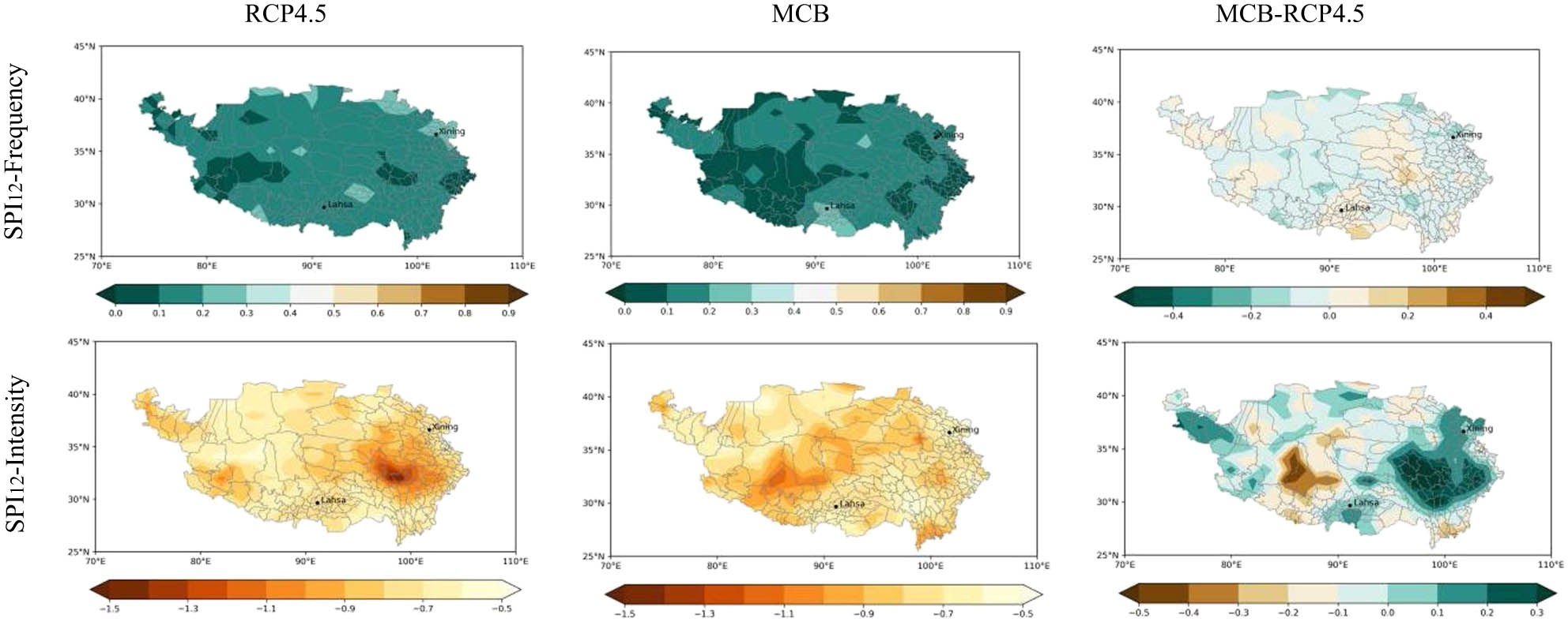
Mean annual SPI during 2030–2059 under the RCP4.5 scenario, MCB scenario, and their difference.
5 Discussion
Compared with the global air temperature of 1850–1900, the mean air temperature of 2001–2020 has risen by about 0.99°C (IPCC 2021). Reducing fossil fuel burning by using energy-saving and emission-reduction technologies in industries and agriculture is clearly the most direct approach to combat the ongoing change in global climate. The known Paris Agreement tried to limit the increase in the global mean temperature to less than 1.5°C/2.0°C. Given the lack of political will to do serious carbon emission reduction, it is far from enough to mitigate global warming [33]. The MCB scheme is expected to cool the Earth by deliberately adding more sea salt cloud condensation nuclei to low marine clouds. It provides an option to flatten the peaks of future climate change without significantly reducing carbon emissions and prevent the most catastrophic consequences at the same time. Since the MCB scheme can be implemented locally and has greater control and flexibility, it is prior to many schemes in climate engineering.
The TP is the world’s highest and largest plateau and holds the largest storage of freshwater outside the Arctic and the Antarctic regions. With the increase in local population and rapid economic development in recent decades, the Qinghai–Tibet Plateau has shown a decline in ecosystem stability, severe land degradation, and increasing ecological and environmental disasters, leading to the continuous increase in the risk of climate disasters. The frequent occurrence of climate extreme events caused by global warming further exacerbates the risk level in the TP. At the same time, the TP holds the largest storage of freshwater outside the Arctic and the Antarctic regions and the sources of major rivers of Asia which provide crucial water resources to many Asian countries. The TP also affects Asia monsoons through temperature contrast between the TP and the Ocean. Therefore, it is urgently needed to find a suitable option to mitigate climate change impacts in the TP. Until now, impacts of MCB schemes and other climate engineering schemes on the TP are always ignored.
In this study, we examined impacts of MCB implementation on climatic extremes over the TP. By analyzing 13 climate extreme indices defined by the ETCCDI and SPI, it was found that MCB implementation would mitigate warming effects and drought effects in the TP:
Warm temperature extremes during 2030–2059: MCB implementation could decrease the intensities of the TXx, TX90p, and TN90p indices, but slightly increase SU and TNx indices. Moreover, MCB implementation would demonstrate statistically significant smaller increasing trend rates for TX90p and TN90p indices in most of the plateau.
Cold temperature extremes: MCB implementation would have cooling effects for the intensities of ID, TXn, TX10p, and TN10p indices. Moreover, MCB implementation would demonstrate statistically significant small decreasing trend rate for ID index and larger deceasing trend rate for TX10p and TN10p indices.
Precipitation extremes and drought: in most regions of the plateau, MCB implementation would increase the CDD index by 0–6 days, decease the CWD index by 0–3 days, and decrease the mean annual Rx5day index by 0–10 mm during 2030–2059, it means that the plateau would become more drier under MCB implementation. MCB implementation would significantly increase the area of the region with <10% drought frequency, and it would also significantly mitigate drought intensity in the eastern plateau and increase drought intensity in the west of Lhasa.
6 Conclusion
The TP is an extremely sensitive region to climate change. As an ecologically fragile region with the highest altitude in the Earth, the TP has grown warmer and wetter over recent decades, contributing to the occurrence of extreme climate events. It is urgently needed to find a suitable option to mitigate climate change impacts in the TP. The MCB scheme is designed to mitigate climate change through the increasing CDNC of low marine clouds to reflect some solar radiation back into space. Our study revealed that although the MCB is implemented over ocean only, it would cause significant changes on climate extremes in the TP which is very far from oceans and much higher than sea level. Especially, MCB implementation would decrease warm temperature extremes and have cooling effects on cold temperature extremes. Although MCB implementation would have no much impacts on precipitation extremes, it would significantly increase the area of the region with <10% drought frequency, and increase the drought intensity in the west of Lhasa city.
-
Funding information: This research was funded by European Commission’s Horizon 2020 Framework Program No. 861584 and Taishan Distinguished Professorship Fund.
-
Author contributions: Z.Z. and Y.Z. have equally contributed to this study.
-
Conflict of interest: Authors state no conflict of interest.
References
[1] Jabal ZK, Khayyun TS, Alwan IA. Impact of climate change on crops productivity using MODIS-NDVI time series. Civ Eng J. 2022;8:1136–56.10.28991/CEJ-2022-08-06-04Search in Google Scholar
[2] Hang NPT. Policy implications for the green bank development in the context of global climate change. Emerg Sci J. 2012;6:817–33.10.28991/ESJ-2022-06-04-011Search in Google Scholar
[3] Ekwueme BN, Agunwamba JC. Trend analysis and variability of air temperature and rainfall in regional river basins. Civ Eng J. 2021;7:816–26.10.28991/cej-2021-03091692Search in Google Scholar
[4] Huisingh D, Zhang Z. Big data mining approaches for helping to reduce and prevent global warming. Int J Big Data Min Glob Warm. 2019;1:1901001.10.1142/S2630534819010010Search in Google Scholar
[5] IPCC. Climate change: The physical science basis. Cambridge: Cambridge University Press; 2021.Search in Google Scholar
[6] Alexander LV, Zhang XB, Peterson TC, Caesar J, Vazquez-Aguirre JL. Global observed changes in daily climate extremes of temperature and precipitation. J Geophys Res Atmos. 2006;111:D05109.10.1029/2005JD006290Search in Google Scholar
[7] Dong B, Sutton RT, Chen W, Liu X, Lu R, Sun Y. Abrupt summer warming and changes in temperature extremes over Northeast Asia since the mid-1990s: drivers and physical processes. Adv Atmos Sci. 2016;33:1005–23.10.1007/s00376-016-5247-3Search in Google Scholar
[8] Wang S, Zhang M, Wang B, Sun M, Li X. Recent changes in daily extremes of temperature and precipitation over the western Tibetan Plateau, 1973–2011. Quat Int. 2013;110–117:313–4.10.1016/j.quaint.2013.03.037Search in Google Scholar
[9] Mearns LO, Hulme M, Carter TR, Leemans R, Lal M, Whetton P, et al. Climate scenario development. In: Climate change 2001: the science of climate change. Cambridge: Cambridge University Press; 2001. p. 739–68.Search in Google Scholar
[10] Latham J. Control of global warming? Nature. 1990;347:339–40.10.1038/347339b0Search in Google Scholar
[11] Stjern CW, Muri H, Ahlm L, Boucher O, Kristjánsson JE. Response to marine cloud brightening in a multi-model ensemble. Atmos Chem Phys. 2017;18:1–20.10.5194/acp-2017-629Search in Google Scholar
[12] Bala G, Caldeira K, Nemani R, Cao L, Ban-Weiss G, Shin HJ. Albedo enhancement of marine clouds to counteract global warming: impacts on the hydrological cycle. Clim Dyn. 2011;37:915–31.10.1007/s00382-010-0868-1Search in Google Scholar
[13] Jones A, Haywood J, Boucher O. Climate impacts of geoengineering marine stratocumulus clouds. J Geophys Res: Atmos. 2009;114:2008JD011450.10.1029/2008JD011450Search in Google Scholar
[14] Kravitz B, Forster PM, Jones A, Robock A, Alterskjaer K, Boucher O, et al. Sea spray geoengineering experiments in the geoengineering model intercomparison project (GeoMIP): Experimental design and preliminary results. J Geophys Res: Atmos. 2013;118:11175–86.10.1002/jgrd.50856Search in Google Scholar
[15] Ahlm L, Jones A, Stjern CW, Muri H, Kravitz B, Kristjánsson JE. Marine cloud brightening – as effective without clouds. Atmos Chem Phys. 2017;17:13071–87.10.5194/acp-17-13071-2017Search in Google Scholar
[16] Horowitz HM, Holmes C, Wright A, Sherwen T, Wang X, Evans M, et al. Effects of sea salt aerosol emissions for marine cloud brightening on atmospheric chemistry: Implications for radiative force. Geophys Res Lett. 2019;47:e2019GL085838.10.1029/2019GL085838Search in Google Scholar PubMed PubMed Central
[17] Mahfouz NGA, Hill SA, Guo H, Ming Y. The radiative and cloud responses to the sea salt aerosol engineering in GFDL models. Geophys Res Lett. 2023;50:2.10.1029/2022GL102340Search in Google Scholar
[18] Latham J, Parkes B, Gadian A, Salter S. Weakening of hurricanes via marine cloud brightening (MCB). Atmos Sci Lett. 2012;13:231–7.10.1002/asl.402Search in Google Scholar
[19] Zhu Y, Zhang Z, Crabbe MJC. Extreme climate response to marine cloud brightening in the arid Sahara-Sahel-Arabian Peninsula zone. Int J Clim Change Strateg Manag. 2021;13:250–65.10.1108/IJCCSM-06-2020-0051Search in Google Scholar
[20] Goddard P, Kravitz B, MacMartin DG, Wang H. The shortwave radiative flux response to an injection of sea salt aerosols in the Gulf of Mexico. J Geophys Res: Atmos. 2022;127:e2022JD037067.10.1029/2022JD037067Search in Google Scholar
[21] Zhang Z, Rinke A, Moore JC. Review of permafrost change on the Tibetan plateau under climatic warming since 1950s. Maejo Int J Sci Tech. 2016;10:242–55.Search in Google Scholar
[22] Ding Z, Wang A, Lu R. An analysis of changes in temperature extremes in the three river headwaters region of the Tibetan plateau during 1961–2016. Atmos Res. 2018;209:103–14.10.1016/j.atmosres.2018.04.003Search in Google Scholar
[23] Yang T, Hao X, Shao Q, Xu CY, Zhao C, Chen X, et al. Multi-model ensemble projections in temperature and precipitation extremes of the Tibetan Plateau in the 21st century. Glob Planet Change. 2021;80–81:1–13.10.1016/j.gloplacha.2011.08.006Search in Google Scholar
[24] IPCC. Fifth Assessment Report (AR5). United Nations; 2013.Search in Google Scholar
[25] Zhang Z, Moore JC, Huisingh D, Zhao Y. Review of geoengineering approaches to mitigating climate change. J Clean Prod. 2015;103:898–907.10.1016/j.jclepro.2014.09.076Search in Google Scholar
[26] Kang S, Xu Y, You Q, Flügel WA, Pepin N, Yao T. Review of climate and cryospheric change in the Tibetan Plateau. Environ Res Lett. 2010;5:15101.10.1088/1748-9326/5/1/015101Search in Google Scholar
[27] Duan AM, Wu GX. Role of the Tibetan plateau thermal forcing in the summer climate patterns over subtropical Asia. Clim Dyn. 2005;24:793–807.10.1007/s00382-004-0488-8Search in Google Scholar
[28] Moss RH, Edmonds JA, Hibbard KA, Manning MR, Rose SK, van Vuuren DP, et al. The next generation of scenarios for climate change research and assessment. Nature. 2010;463:747–56.10.1038/nature08823Search in Google Scholar PubMed
[29] Meinshausen M, Smith SJ, Calvin K, Daniel JS, Kainuma MLT, Lamarque JF, et al. The RCP greenhouse gas concentrations and their extensions from 1765 to 2300. Clim Change. 2011;109:213.10.1007/s10584-011-0156-zSearch in Google Scholar
[30] Taylor KE, Stouffer RJ, Meehl GA. An overview of CMIP5 and the Experiment Design. Bull Am Meteorol Soc. 2012;93:485–98.10.1175/BAMS-D-11-00094.1Search in Google Scholar
[31] Zhang X, Alexander L, Hegerl G, Jones P, Klein TA, Peterson TC, et al. Indices for monitoring changes in extremes based on daily temperature and precipitation data. Wiley Interdiscip Rev: Clim Change. 2011;2:851–70.10.1002/wcc.147Search in Google Scholar
[32] Guttman NB. Accepting the standardized precipitation index: A calculation algorithm. J Am Water Resour Assoc. 1999;35:311–22.10.1111/j.1752-1688.1999.tb03592.xSearch in Google Scholar
[33] Sanderson BM, O’Neill BC, Tebaldi C. What would it take to achieve the Paris temperature targets? Geophys Res Lett. 2016;43:7133–42.10.1002/2016GL069563Search in Google Scholar
© 2023 the author(s), published by De Gruyter
This work is licensed under the Creative Commons Attribution 4.0 International License.
Articles in the same Issue
- Regular Articles
- Diagenesis and evolution of deep tight reservoirs: A case study of the fourth member of Shahejie Formation (cg: 50.4-42 Ma) in Bozhong Sag
- Petrography and mineralogy of the Oligocene flysch in Ionian Zone, Albania: Implications for the evolution of sediment provenance and paleoenvironment
- Biostratigraphy of the Late Campanian–Maastrichtian of the Duwi Basin, Red Sea, Egypt
- Structural deformation and its implication for hydrocarbon accumulation in the Wuxia fault belt, northwestern Junggar basin, China
- Carbonate texture identification using multi-layer perceptron neural network
- Metallogenic model of the Hongqiling Cu–Ni sulfide intrusions, Central Asian Orogenic Belt: Insight from long-period magnetotellurics
- Assessments of recent Global Geopotential Models based on GPS/levelling and gravity data along coastal zones of Egypt
- Accuracy assessment and improvement of SRTM, ASTER, FABDEM, and MERIT DEMs by polynomial and optimization algorithm: A case study (Khuzestan Province, Iran)
- Uncertainty assessment of 3D geological models based on spatial diffusion and merging model
- Evaluation of dynamic behavior of varved clays from the Warsaw ice-dammed lake, Poland
- Impact of AMSU-A and MHS radiances assimilation on Typhoon Megi (2016) forecasting
- Contribution to the building of a weather information service for solar panel cleaning operations at Diass plant (Senegal, Western Sahel)
- Measuring spatiotemporal accessibility to healthcare with multimodal transport modes in the dynamic traffic environment
- Mathematical model for conversion of groundwater flow from confined to unconfined aquifers with power law processes
- NSP variation on SWAT with high-resolution data: A case study
- Reconstruction of paleoglacial equilibrium-line altitudes during the Last Glacial Maximum in the Diancang Massif, Northwest Yunnan Province, China
- A prediction model for Xiangyang Neolithic sites based on a random forest algorithm
- Determining the long-term impact area of coastal thermal discharge based on a harmonic model of sea surface temperature
- Origin of block accumulations based on the near-surface geophysics
- Investigating the limestone quarries as geoheritage sites: Case of Mardin ancient quarry
- Population genetics and pedigree geography of Trionychia japonica in the four mountains of Henan Province and the Taihang Mountains
- Performance audit evaluation of marine development projects based on SPA and BP neural network model
- Study on the Early Cretaceous fluvial-desert sedimentary paleogeography in the Northwest of Ordos Basin
- Detecting window line using an improved stacked hourglass network based on new real-world building façade dataset
- Automated identification and mapping of geological folds in cross sections
- Silicate and carbonate mixed shelf formation and its controlling factors, a case study from the Cambrian Canglangpu formation in Sichuan basin, China
- Ground penetrating radar and magnetic gradient distribution approach for subsurface investigation of solution pipes in post-glacial settings
- Research on pore structures of fine-grained carbonate reservoirs and their influence on waterflood development
- Risk assessment of rain-induced debris flow in the lower reaches of Yajiang River based on GIS and CF coupling models
- Multifractal analysis of temporal and spatial characteristics of earthquakes in Eurasian seismic belt
- Surface deformation and damage of 2022 (M 6.8) Luding earthquake in China and its tectonic implications
- Differential analysis of landscape patterns of land cover products in tropical marine climate zones – A case study in Malaysia
- DEM-based analysis of tectonic geomorphologic characteristics and tectonic activity intensity of the Dabanghe River Basin in South China Karst
- Distribution, pollution levels, and health risk assessment of heavy metals in groundwater in the main pepper production area of China
- Study on soil quality effect of reconstructing by Pisha sandstone and sand soil
- Understanding the characteristics of loess strata and quaternary climate changes in Luochuan, Shaanxi Province, China, through core analysis
- Dynamic variation of groundwater level and its influencing factors in typical oasis irrigated areas in Northwest China
- Creating digital maps for geotechnical characteristics of soil based on GIS technology and remote sensing
- Changes in the course of constant loading consolidation in soil with modeled granulometric composition contaminated with petroleum substances
- Correlation between the deformation of mineral crystal structures and fault activity: A case study of the Yingxiu-Beichuan fault and the Milin fault
- Cognitive characteristics of the Qiang religious culture and its influencing factors in Southwest China
- Spatiotemporal variation characteristics analysis of infrastructure iron stock in China based on nighttime light data
- Interpretation of aeromagnetic and remote sensing data of Auchi and Idah sheets of the Benin-arm Anambra basin: Implication of mineral resources
- Building element recognition with MTL-AINet considering view perspectives
- Characteristics of the present crustal deformation in the Tibetan Plateau and its relationship with strong earthquakes
- Influence of fractures in tight sandstone oil reservoir on hydrocarbon accumulation: A case study of Yanchang Formation in southeastern Ordos Basin
- Nutrient assessment and land reclamation in the Loess hills and Gulch region in the context of gully control
- Handling imbalanced data in supervised machine learning for lithological mapping using remote sensing and airborne geophysical data
- Spatial variation of soil nutrients and evaluation of cultivated land quality based on field scale
- Lignin analysis of sediments from around 2,000 to 1,000 years ago (Jiulong River estuary, southeast China)
- Assessing OpenStreetMap roads fitness-for-use for disaster risk assessment in developing countries: The case of Burundi
- Transforming text into knowledge graph: Extracting and structuring information from spatial development plans
- A symmetrical exponential model of soil temperature in temperate steppe regions of China
- A landslide susceptibility assessment method based on auto-encoder improved deep belief network
- Numerical simulation analysis of ecological monitoring of small reservoir dam based on maximum entropy algorithm
- Morphometry of the cold-climate Bory Stobrawskie Dune Field (SW Poland): Evidence for multi-phase Lateglacial aeolian activity within the European Sand Belt
- Adopting a new approach for finding missing people using GIS techniques: A case study in Saudi Arabia’s desert area
- Geological earthquake simulations generated by kinematic heterogeneous energy-based method: Self-arrested ruptures and asperity criterion
- Semi-automated classification of layered rock slopes using digital elevation model and geological map
- Geochemical characteristics of arc fractionated I-type granitoids of eastern Tak Batholith, Thailand
- Lithology classification of igneous rocks using C-band and L-band dual-polarization SAR data
- Analysis of artificial intelligence approaches to predict the wall deflection induced by deep excavation
- Evaluation of the current in situ stress in the middle Permian Maokou Formation in the Longnüsi area of the central Sichuan Basin, China
- Utilizing microresistivity image logs to recognize conglomeratic channel architectural elements of Baikouquan Formation in slope of Mahu Sag
- Resistivity cutoff of low-resistivity and low-contrast pays in sandstone reservoirs from conventional well logs: A case of Paleogene Enping Formation in A-Oilfield, Pearl River Mouth Basin, South China Sea
- Examining the evacuation routes of the sister village program by using the ant colony optimization algorithm
- Spatial objects classification using machine learning and spatial walk algorithm
- Study on the stabilization mechanism of aeolian sandy soil formation by adding a natural soft rock
- Bump feature detection of the road surface based on the Bi-LSTM
- The origin and evolution of the ore-forming fluids at the Manondo-Choma gold prospect, Kirk range, southern Malawi
- A retrieval model of surface geochemistry composition based on remotely sensed data
- Exploring the spatial dynamics of cultural facilities based on multi-source data: A case study of Nanjing’s art institutions
- Study of pore-throat structure characteristics and fluid mobility of Chang 7 tight sandstone reservoir in Jiyuan area, Ordos Basin
- Study of fracturing fluid re-discharge based on percolation experiments and sampling tests – An example of Fuling shale gas Jiangdong block, China
- Impacts of marine cloud brightening scheme on climatic extremes in the Tibetan Plateau
- Ecological protection on the West Coast of Taiwan Strait under economic zone construction: A case study of land use in Yueqing
- The time-dependent deformation and damage constitutive model of rock based on dynamic disturbance tests
- Evaluation of spatial form of rural ecological landscape and vulnerability of water ecological environment based on analytic hierarchy process
- Fingerprint of magma mixture in the leucogranites: Spectroscopic and petrochemical approach, Kalebalta-Central Anatolia, Türkiye
- Principles of self-calibration and visual effects for digital camera distortion
- UAV-based doline mapping in Brazilian karst: A cave heritage protection reconnaissance
- Evaluation and low carbon ecological urban–rural planning and construction based on energy planning mechanism
- Modified non-local means: A novel denoising approach to process gravity field data
- A novel travel route planning method based on an ant colony optimization algorithm
- Effect of time-variant NDVI on landside susceptibility: A case study in Quang Ngai province, Vietnam
- Regional tectonic uplift indicated by geomorphological parameters in the Bahe River Basin, central China
- Computer information technology-based green excavation of tunnels in complex strata and technical decision of deformation control
- Spatial evolution of coastal environmental enterprises: An exploration of driving factors in Jiangsu Province
- A comparative assessment and geospatial simulation of three hydrological models in urban basins
- Aquaculture industry under the blue transformation in Jiangsu, China: Structure evolution and spatial agglomeration
- Quantitative and qualitative interpretation of community partitions by map overlaying and calculating the distribution of related geographical features
- Numerical investigation of gravity-grouted soil-nail pullout capacity in sand
- Analysis of heavy pollution weather in Shenyang City and numerical simulation of main pollutants
- Road cut slope stability analysis for static and dynamic (pseudo-static analysis) loading conditions
- Forest biomass assessment combining field inventorying and remote sensing data
- Late Jurassic Haobugao granites from the southern Great Xing’an Range, NE China: Implications for postcollision extension of the Mongol–Okhotsk Ocean
- Petrogenesis of the Sukadana Basalt based on petrology and whole rock geochemistry, Lampung, Indonesia: Geodynamic significances
- Numerical study on the group wall effect of nodular diaphragm wall foundation in high-rise buildings
- Water resources utilization and tourism environment assessment based on water footprint
- Geochemical evaluation of the carbonaceous shale associated with the Permian Mikambeni Formation of the Tuli Basin for potential gas generation, South Africa
- Detection and characterization of lineaments using gravity data in the south-west Cameroon zone: Hydrogeological implications
- Study on spatial pattern of tourism landscape resources in county cities of Yangtze River Economic Belt
- The effect of weathering on drillability of dolomites
- Noise masking of near-surface scattering (heterogeneities) on subsurface seismic reflectivity
- Query optimization-oriented lateral expansion method of distributed geological borehole database
- Petrogenesis of the Morobe Granodiorite and their shoshonitic mafic microgranular enclaves in Maramuni arc, Papua New Guinea
- Environmental health risk assessment of urban water sources based on fuzzy set theory
- Spatial distribution of urban basic education resources in Shanghai: Accessibility and supply-demand matching evaluation
- Spatiotemporal changes in land use and residential satisfaction in the Huai River-Gaoyou Lake Rim area
- Walkaway vertical seismic profiling first-arrival traveltime tomography with velocity structure constraints
- Study on the evaluation system and risk factor traceability of receiving water body
- Predicting copper-polymetallic deposits in Kalatag using the weight of evidence model and novel data sources
- Temporal dynamics of green urban areas in Romania. A comparison between spatial and statistical data
- Passenger flow forecast of tourist attraction based on MACBL in LBS big data environment
- Varying particle size selectivity of soil erosion along a cultivated catena
- Relationship between annual soil erosion and surface runoff in Wadi Hanifa sub-basins
- Influence of nappe structure on the Carboniferous volcanic reservoir in the middle of the Hongche Fault Zone, Junggar Basin, China
- Dynamic analysis of MSE wall subjected to surface vibration loading
- Pre-collisional architecture of the European distal margin: Inferences from the high-pressure continental units of central Corsica (France)
- The interrelation of natural diversity with tourism in Kosovo
- Assessment of geosites as a basis for geotourism development: A case study of the Toplica District, Serbia
- IG-YOLOv5-based underwater biological recognition and detection for marine protection
- Monitoring drought dynamics using remote sensing-based combined drought index in Ergene Basin, Türkiye
- Review Articles
- The actual state of the geodetic and cartographic resources and legislation in Poland
- Evaluation studies of the new mining projects
- Comparison and significance of grain size parameters of the Menyuan loess calculated using different methods
- Scientometric analysis of flood forecasting for Asia region and discussion on machine learning methods
- Rainfall-induced transportation embankment failure: A review
- Rapid Communication
- Branch fault discovered in Tangshan fault zone on the Kaiping-Guye boundary, North China
- Technical Note
- Introducing an intelligent multi-level retrieval method for mineral resource potential evaluation result data
- Erratum
- Erratum to “Forest cover assessment using remote-sensing techniques in Crete Island, Greece”
- Addendum
- The relationship between heat flow and seismicity in global tectonically active zones
- Commentary
- Improved entropy weight methods and their comparisons in evaluating the high-quality development of Qinghai, China
- Special Issue: Geoethics 2022 - Part II
- Loess and geotourism potential of the Braničevo District (NE Serbia): From overexploitation to paleoclimate interpretation