Geocultural heritage as a basis for geotourism development: Banjska Monastery, Zvečan (Serbia)
-
Nikola R. Bačević


Abstract
The Banjska Monastery is a medieval monastery in Serbia of great cultural and spiritual importance to the Serbian population, as it served as the endowment and burial church of King Milutin, a powerful Serbian ruler of the fourteenth century. This article aims to assess the geoheritage value of the Banjska Monastery, located near Zvečan, using the Urban Geoheritage Assessment Model (UGAM), and to explore its potential for geotourism development by converting its heritage value into tourism value. To support UGAM parameters (such as educational potential, geoheritage diversity, and paleontological significance), macroscopic observations of the building stones were conducted, along with petrological analyses of five samples collected from the monastery and micropaleontological investigations of three limestone samples. These analyses aimed to identify microfacies, composition, structural characteristics, and sedimentary environments. The investigation revealed two rock types: sedimentary rocks (limestone, sandstone, and tufa) and metamorphic rocks (marble). UGAM results revealed high scores for scientific and natural value, confirming the site’s strong potential for urban geotourism development. However, the model also highlighted deficiencies in tourist infrastructure, particularly in information boards, guided tours, and visitor centers. These findings may assist local policymakers and stakeholders in converting natural heritage values into tourism assets.
1 Introduction
Geotourism, in its various forms, has gained significant popularity in academic, educational, and practical contexts over the past decade [1]. Rapidly evolving tourism demands have prompted the industry to adapt to these changes and align with modern tourism trends [2]. Urban geotourism involves the integration of geological features, landscapes, and processes into tourism activities within urban environments [3,4,5,6]. Unlike traditional geotourism, urban geotourism emphasizes the geological heritage found in urban settings [7]. Urban geosites encompass aspects of geodiversity with cultural, educational, and scientific value, necessitating evaluation, management, and conservation efforts that should be promoted through tourism [2]. The relationship between geoheritage and cultural heritage is receiving increasing attention and has become a popular focus in studies of geoheritage and geodiversity [3,4,8,9,10,11,12,13]. Although a geocultural site may primarily hold cultural value, this should not diminish the significance of its geodiversity and geoheritage. Numerous examples illustrate the interconnection between cultural and geodiversity values, such as Mont-Saint-Michel in Normandy (France), a commune and monastery built on a rocky tidal island [14], and Petra in Jordan, an archaeological site carved into red sandstone outcrops [15]. These sites serve as compelling examples of geoheritage that have supported the development of outstanding cultural and architectural heritage.
Geoeducation is a vital component of geotourism, aiming to inform and educate visitors about a geosite’s natural and cultural heritage, with a particular focus on its geological features and processes [16]. It can foster environmental awareness among tourists and stakeholders, promoting responsible behavior toward the natural environment [17]. Geoethics represents an essential aspect of modern geotourism, providing a framework that encourages responsible and sustainable practices in the geosciences. This framework emphasizes the importance of balancing scientific advancement, economic development, and environmental protection [18]. Geoeducation and geoethics are closely interrelated, working together to support the preservation of geological diversity [19].
Assessing geosites is considered an essential tool for their conservation, sustainable development, and educational promotion [20]. Such assessments can support decision-making and tourism planning, while also fostering collaboration among stakeholders. In recent years, various tools have been developed to evaluate the geoheritage tourism potential of sites, each differing in focus, scope, and purpose [21,22,23,24,25,26,27,28,29]. However, there remains a need for new, specialized methods that can evaluate niche segments within geotourism and provide a more comprehensive approach to assessing the educational value of geoheritage.
This article aims to assess the urban geoheritage potential of the geocultural site Banjska Monastery, near Zvečan, using the Urban Geoheritage Assessment Model (UGAM) [12]. UGAM integrates situational analysis, offering insights into the current conditions and future prospects of urban geosites, while identifying tourism potentials that can be transformed into valuable tourism assets. The data generated through this analysis support the modeling process, aiding policymakers and stakeholders in developing strategic frameworks for sustainable tourism development. To support specific UGAM subindicators – such as educational potential and paleontological significance – macroscopic and microscopic petrographic–mineralogical observations of the building stones of Banjska Monastery were conducted.
2 Study area
2.1 Archaeological background
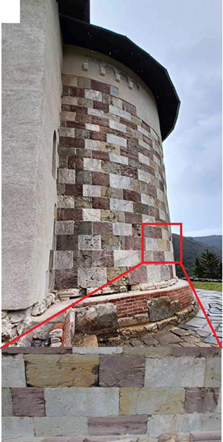
The Banjska Monastery, with the Church of Saint Stephen (Figure 1), was established in the second decade of the fourteenth century as an endowment and burial church of King Milutin [30]. It is reported that during his 40-year reign, King Milutin built or restored around forty churches, located in Serbia, Thessalonica, Mount Athos, Constantinople, and even in more distant regions, including the Holy Land and Jerusalem. The Banjska Monastery was likely inspired by the nearby Studenica Monastery – a UNESCO World Heritage Site – built in the twelfth century [31]. Following the Battle of Kosovo in 1389, Banjska Monastery was set on fire. The relics of King Milutin were transferred to the Cathedral of Saint Nedelya in Sofia, Bulgaria, where they remain today. The first demolitions of the monastery began in the early sixteenth century. In the following century, the church was converted into a mosque, and the monastery complex became a Turkish fortress, which was abandoned in 1912 with the onset of the First Balkan War. In the second year of World War I, amateur excavations within the monastery complex unearthed two rings. It was later published that these were found in a woman’s tomb [32], believed to belong to Queen Teodora, mother of Emperor Stefan Dušan (r. 1331–1355). Stefan Dušan proclaimed himself King of Serbia in 1331 and, in 1346, crowned himself Emperor of Serbs and Greeks, establishing the Serbian Empire. However, the description of the findings was unclear, and it appears that not both rings were discovered in the same grave. It was suggested that Queen Simonida, the last wife of King Milutin, was intended to be buried at Banjska, but she spent her final years in Constantinople as a nun. It is also known that the tomb underwent changes in size – possibly enlarged to accommodate a man. A century after the rings were found, one of them was associated with Konstantine, son of King Milutin, who was buried at Banjska Monastery. Further details about the rings were published by Todorović [33], while the identification of the tombs was recently discussed by Popović [34]. Another extraordinary find in the ruins of Banjska Monastery was seven fragments of a sarcophagus lid dated to 1313/1314. Sarcophagus lids with inscriptions are rare in medieval Serbia, and this one is estimated to have been 4 m long.

The exterior of Banjska Monastery and the entrance of the church of St. Stephen.
At his own expense, architect Đurđe Bošković studied the Banjska Monastery, exploring the ruins of the church, which at the time were buried beneath the topographic surface [35]. Bošković [35] identified multiple construction phases, noting that after the initial building of the church, two towers were added and the monastery was enclosed by walls. Prior to the outbreak of World War II, he was appointed to lead the conservation of the church. His aim was to preserve as much of the original structure as possible, without adding new elements or removing old ones. The vaults were reconstructed using bricks, concrete, and tufa.
Opinions remain divided regarding the final appearance of the restored Banjska Monastery. Some argue that the intervention cannot be classified as conservation, since more than half of the structure was rebuilt using brick; nor can it be considered a restoration, as the monument did not regain its original form. Nevertheless, it is a positive outcome that the church is now functional again after a 520-year hiatus, although its appearance is considered by some to be aesthetically inconsistent. The Archaeological Institute of Belgrade holds daily reports and photographic documentation from the 1960 investigations of Banjska Monastery. In 2002, a revitalization decision included the construction of a monastic residence and lapidarium, which was to follow archaeological research. When spiritual life at the monastery was revived in 2004, a fresco transferred from the nearby church in Zvečan was installed in the church.
2.2 Geographical settings
Not far from the tripoint where Serbia, Albania, and Montenegro meet lies one of the most significant monasteries of medieval Serbia – the Banjska Monastery (Figure 2). It is nestled in a picturesque landscape along the banks of the Banjska River, a right tributary of the Ibar River, at the foot of Mount Rogozna. The monastery is situated near the route of the former cobblestone road that once connected Constantinople to Dubrovnik [36].
![Figure 2
The location of the Banjska Monastery in Serbia and local setting [38] (modification).](/document/doi/10.1515/geo-2025-0863/asset/graphic/j_geo-2025-0863_fig_002.jpg)
The location of the Banjska Monastery in Serbia and local setting [38] (modification).
Today, Banjska Monastery is accessible via a 55 km road from Priština or a 15 km road from Kosovska Mitrovica. It is located 3.30 km west of the confluence of the Banjska and Ibar rivers, standing at an elevation of 576 m above sea level and 46 m above the Banjska River. The Banjska River valley faces east. Nearby peaks include Glavica (954 m) to the south, Kovački Orlovac (698 m) to the southeast, and an unnamed peak (720 m) to the north. The average annual temperature from 1950 to 2022 was 8.2°C, with an average annual precipitation of 764 mm [37].
The geological setting around the Banjska Monastery is highly diverse (Figure 3). To the southeast and northwest of the monastery, past volcanic activity has left numerous geological features, ranging from preserved volcanic cones to volcanogenic-sedimentary rocks. The most recent eruptions in the area occurred during the Miocene epoch. Geologically, the monastery is located at the boundary between the Drina-Ivanjica thrust sheet and the Western Vardar ophiolites [39].
![Figure 3
Geological setting of the same area as in Figure 2. Monastery is presented with the red circle, and settlements are presented with the grey squares (modified after General Geological Map of SFRY, sheet Titova Mitrovica 34-42 [60]).](/document/doi/10.1515/geo-2025-0863/asset/graphic/j_geo-2025-0863_fig_003.jpg)
Volcanic activity on Mount Rogozna, where the monastery stands on its southern slopes, occurred in two phases. The older phase took place during the Oligocene, over 30 million years ago, while the younger phase, dated between 29 and 24 million years ago, produced quartz-latite to rhyodacite lava flows. This volcanism is part of the Circum-Mediterranean Igneous Province, which spans from Serbia through North Macedonia and Greece to Turkey [40]. As a result of this volcanic activity, the Rogozna area is rich in lead, zinc, silver, copper, bismuth, cadmium, and gold [41].
The monastery itself is situated on serpentinite bedrock, through which the Ibar River has carved its valley. The Banjska River flows along the contact zone between Upper Cretaceous flysch and altered Middle Triassic serpentinites. Between the Banjska River and the monastery, a modern spa complex has been developed on a thermal spring. It is likely that the name “Banjska” is derived from the Serbian word for spa – banja.
3 Methodology
The assessment of the urban geotourism potential of Banjska Monastery was conducted using the UGAM model, supported by macroscopic and microscopic observations of the building stone, along with petrological and paleontological investigations. These investigations aimed to provide detailed insights into the composition and characteristics of the building materials, thereby supporting UGAM parameters such as geodiversity variety, paleontological significance, educational potential, and the visibility of geodiversity features.
Considering the location of Banjska Monastery, situated in the center of Banjska Spa and only 10 km from the urban center of Zvečan, the UGAM model proved to be more applicable than other models used for the touristic evaluation of geosites (such as GAM, MGAM, and SCAM). Its primary advantage lies in its inclusion of a broader range of parameters for evaluating urban geosites, including geocultural value, geohistorical value, and paleontological significance.
Petrological and paleontological research and conclusions were based on fieldwork and the analysis of various databases, including SQL, NoSQL, and GeoSciML. The collected data are visualized using tools, such as GIS, ArcGIS, and QGIS, that enable precise processing of spatial data and their visualization in the form of a thematic map. For the purpose of displaying various spatial relationships, different models are used, such as digital relief models and digital terrain models.
3.1 Macroscopic observations
Macroscopic observations were conducted to identify the key mineralogical and petrographic features of the building stones used in the construction of Banjska Monastery. The term “building stone” refers to the stone materials incorporated into the monastery’s structures, including the church dedicated to St. Stephen. These observations focused on characteristics such as color, mineral composition, and texture to enable accurate rock classification. The analysis involved visual inspections with the naked eye and a magnifying lens, as well as hardness tests performed by scratching the stone with a fingernail and brass coins. This study did not aim to examine every stone type and variety present at the site. Rather, it concentrated on stones exhibiting notable macroscopic diversity that are easily accessible and distinguishable, particularly those prominently visible, emphasizing their potential value for geotourism.
3.2 Petrological investigations
Five rock samples were collected from the walls of the Banjska Monastery (Figure 4). Transparent petrographic sections were made from the samples. The sections were observed under “Carl Zeiss” polarizing microscope, using 8× magnification for the eyepiece and 2.5× and 6.3× for the objective, depending on whether details or the rock structure were being examined.

Sampling location of Banjska Monastery. Sampled on 03.04.2024.
3.3 Paleontological investigations
For the needs of the Banjska Monastery, the age of 3 limestone samples was determined. Transparent sections of sedimentary rock samples were made on glass slides using the thin-section method. Micropaleontological studies were conducted using an Orton brand transmitted light microscope. Microfossil (microfauna) sections were examined using two eyepieces with magnifications of 2.5× (for specimen overview) and 10× (for detailed examination and precise species determination).
3.4 UGAM analysis
This study aims to evaluate the urban geotourism potential of Banjska Monastery using the UGAM developed by Marjanović et al. [12] (Table 1). The UGAM model integrates several existing geoheritage assessment frameworks [29,42,43,44,45], specifically adapted for evaluating urban geoheritage. It comprises two primary categories of value indicators: Urban Geosite Value (UGV) and Tourism Value (TV). The UGV is assessed through 13 sub-indicators, while the TV is evaluated using 12 sub-indicators (see Table 1). Following the site assessment, results are presented in the UGAM matrix (Figure 16). Marjanović et al. [12] conducted a survey to analyze the urban geotourism segment and calculated an importance factor (Im) for each UGAM sub-indicator, with a focus on Serbian tourists. The importance factor values used in this study were adopted from their findings. A detailed overview of the UGAM model can be found in Marjanović et al. [12]. This model has been successfully applied to other geocultural sites in Serbia, such as the archaeological site Felix Romuliana near Zaječar [12] and the Sokograd fortress near Sokobanja [13]. The findings of this article will be compared with those from these previously studied sites.
Structure of the UGAM model values
| Indicators | Subindicators | Description of criteria | |
|---|---|---|---|
| UGV | Scientific values (SVa) | Representativeness (SIUGV1) | The characteristics of the site itself, the level of processes or elements of geodiversity that can be observed on site compared to the ideal example |
| Rarity (SIUGV2) | Number of similar localities within the researched area | ||
| Paleo significance (SIUGV3) | The possibility of presenting paleogeographical elements or processes; reconstruction of relief, climate, distribution of organisms and organic matter (paleoclimatology, paleobiogeography, paleogeomorphology, paleoglaciology, paleoecology, paleovolcanology) | ||
| Geohistorical values (SITV4) | The link between geodiversity and site history; the importance of geodiversity characteristics for urban spatial development; and its ability to stimulate connection with the past | ||
| Geocultural values (SITV5) | The cultural connection of the site with geodiversity, anthropogenic forms of relief, the use of built materials and techniques in the construction of a local or regional character or a wider area | ||
| Ecological values (SITV6) | Presence of specific or rare species, important or endangered ecosystems | ||
| Natural values (NVa) | Aesthetic values (SIUGV7) | Visual attractiveness of the site, colour contrast, structure of the surrounding area, attractiveness of the panoramic view | |
| Variety of geodiversity (SIUGV8) | The number of different forms of geodiversity in the locality (geological, geomorphological, hydrological, speleological, paleontological) | ||
| Surface (SIUGV9) | Total surface of the site. Each site is quantitatively compared with other valued sites | ||
| Protection (PVa) | Integrity (SIUGV10) | Current state of the site, degree of damage, state of representative elements of geodiversity | |
| Protection (SIUGV11) | Level of site protection | ||
| Threats to the site (SIUGV12) | Possible threats to geodiversity; risks and hazards (anthropogenic and natural) | ||
| Carrying capacity (SIUGV13) | The maximum number of visitors to the site, whose presence will not damage the current state of the site and reduce its visual quality | ||
| TVs | Education (SITV1) | The possibility of interpretation, the possibility for people without geological knowledge to understand the elements and processes | |
| Accessibility (SITV2) | The possibility of reaching the locality | ||
| Visitor safety (SITV3) | The ability of visitors to move safely throughout the site (danger of landslides, slippery surface, safety fence, proximity to busy traffic) | ||
| Visibility (SITV4) | The level of visibility of the specificity of geodiversity, the position of the geosite concerning the viewpoint or path, the number of viewpoints, the vegetation around the geosite, the discovery of the geosite | ||
| Promotional activities (SITV5) | Quality and diversity of promotional activities | ||
| Number of visitors (SITV6) | Number of visitors during the year | ||
| Information boards (SITV7) | Number and quality of information boards (quality of textual and illustrative content, display of content in colour, multilingual interpretation, materials in harmony with nature) | ||
| Tourguide service (SITV8) | Quality of interpretation, level of expertise, multilingual interpretation | ||
| Information center (SITV9) | Proximity to the information center (tourist, visitor) | ||
| Tourist infrastructure (SITV10) | Footpaths, rest areas, waste disposal areas, toilets, paths for people with disabilities | ||
| Accommodation (SITV11) | Proximity to accommodation facilities | ||
| Restaurant services (SITV12) | Proximity to restaurant facilities |
| Values (1–5) | 1 | 2 | 3 | 4 | 5 | |
|---|---|---|---|---|---|---|
| SIUGV1 | Representativeness | Not representative | Low | Medium | High | Very high |
| SIUGV2 | Rarity | Usual | Local | Regional | National | International |
| SIUGV3 | Paleo significance | None | Low | Medium | High | Very high |
| SIUGV4 | Geohistorical values | None | Low | Medium | High | Very high |
| SIUGV5 | Geocultural values | None | Low | Medium | High | Very high |
| SIUGV6 | Ecological values | None | Low | Medium | High | Very high |
| SIUGV7 | Aesthetic values | None | Low | Medium | High | Very high |
| SIUGV8 | Variety of geodiversity | Only 1 | 2–3 | 4–5 | 6–7 | 8 and more |
| SIUGV9 | Surface | Small | Small/Medium | Medium | Medium/Large | Large |
| SIUGV10 | Integrity | Totally destroyed, with no possibility of reconstruction | Mostly destroyed, with the possibility of reconstruction | Partially destroyed | A little ruined | Not destroyed |
| SIUGV11 | Protection | None | Local | Regional | National | International |
| SIUGV12 | Threats to the site | Very high level of threats (constant anthropogenic pressure that can lead to the total destruction of geodiversity); there is no protection plan | High level (frequent anthropogenic pressure), there is a plan for partial pressure reduction | Medium level (occasional anthropogenic pressure, small possibility of natural disasters), there is a plan to reduce the pressure if it happens | Low level (possibility of natural disasters), there is a plan for their reduction | There are no serious threats to the site (anthropogenic and natural) |
| SIUGV13 | Carrying capacity | 1–10 | 11–20 | 21–30 | 31–40 | over 41 |
| SITV1 | Education | None (phenomena and processes are poorly developed and not suitable for education) | Low (phenomena and processes are difficult to understand even with an expert guide) | Medium (phenomena and processes are understandable, but with an explanation by a professional guide) | High (phenomena and processes are understandable with the help of an info board, map, and written or audio guides) | Very high (phenomena and processes are easy to understand even without additional interpretive content) |
| SITV2 | Accessibility | Difficult to access (accessible with special equipment) | Accessible on foot | Accessible by bike | Accessible by car | Accessible by mini-bus, tourist bus |
| SITV3 | Visitor safety | It is not safe to be on the site (active processes of landslides and landslides), the possibility of visiting at your own risk | Low level of security, there are frequent threats to the safety of visitors, but the movement around the site is possible with a special permit and equipment | Medium level of security, there are threats to the safety of visitors, but the movement around the site is possible with compliance with the rules; not suitable for larger groups; close to a heavy-traffic street | High level of security, there are small threats to the safety of visitors, but their existence does not represent a potential risk; no heavy-traffic streets nearby | It is completely safe, there are no threats to the safety of visitors |
| SITV4 | Visibility | Very hard to see | Low visibility, partial exposure of the site (visible from only one angle – 1 viewpoint) | Medium visibility, clearly visible from two angles (2 viewpoints) | High visibility, clearly visible from three angles (3 viewpoints) | Full visibility, clearly visible from 4 and more angles |
| SITV5 | Promotional activities | None | Local | Regional | National | International |
| SITV6 | Number of visitors | Random visitors (0–50) | Low (51–10,000) | Medium (10,000–50,000) | High (50,001–100,000) | Very high (over 100,000) |
| SITV7 | Information boards | None | Low | Medium | High | Very high |
| SITV8 | Tourguide service | None | Low | Medium | High | Very high |
| SITV9 | Information center | More than 50 km | 10–50 km | 10–5 km | 5–1 km | Less than 1 km |
| SITV10 | Tourist infrastructure | None | Low quality | Medium quality | High quality | Very high quality |
| SITV11 | Accommodation | Over 50 km | 20–50 km | 20–10 km | 10–5 km | Less than 5 km |
| SITV12 | Restaurant services | Over 15 km | 15–10 km | 10–5 km | 5–1 km | Less than 1 km |
4 Results
The results of the macroscopic and microscopic investigations are presented in the next few sections. The results of the UGAM analysis are presented in Tables 2 and 3, as well in Figure 16.
Subindicator values given by authors for the Banjska Monastery
| Subindicators | Values given by the authors | Im | Total score | |
|---|---|---|---|---|
| UGVs | ||||
| Scientific values | ||||
| SIUGV1 | Representativeness | 3 | 3.94 | 11.82 |
| SIUGV2 | Rarity | 2 | 3.52 | 7.04 |
| SIUGV3 | Paleo significance | 4 | 3.14 | 12.56 |
| SIUGV4 | Geohistorical values | 5 | 3.78 | 18.90 |
| SIUGV5 | Geocultural values | 4 | 4.00 | 16.00 |
| SIUGV6 | Ecological values | 4 | 3.58 | 14.32 |
| Natural values | ||||
| SIUGV7 | Aesthetic values | 4 | 4.36 | 17.44 |
| SIUGV8 | Variety of geodiversity | 4 | 2.87 | 11.48 |
| SIUGV9 | Surface | 2 | 2.45 | 4.9 |
| Protection | ||||
| SIUGV10 | Integrity | 3 | 3.78 | 11.34 |
| SIUGV11 | Protection level | 4 | 4.14 | 16.56 |
| SIUGV12 | Threats to the site | 5 | 3.25 | 16.25 |
| SIUGV13 | Carrying capacity | 4 | 3.07 | 12.28 |
| Touristic values | ||||
| SITV1 | Education | 5 | 4.31 | 21.55 |
| SITV2 | Accessibility | 4 | 2.74 | 10.96 |
| SITV3 | Visitor safety | 4 | 3.09 | 12.36 |
| SITV4 | Visibility | 4 | 3.83 | 15.32 |
| SITV5 | Promotional activities | 2 | 2.69 | 5.38 |
| SITV6 | Number of visitors | 2 | 2.83 | 5.66 |
| SITV7 | Informative boards | 1 | 4.00 | 4.00 |
| SITV8 | Tourguide service | 1 | 4.07 | 4.07 |
| SITV9 | Information centre | 1 | 3.69 | 3.69 |
| SITV10 | Tourist infrastructure | 2 | 4.12 | 8.24 |
| SITV11 | Accommodation | 5 | 3.43 | 17.15 |
| SITV12 | Restaurant service | 5 | 3.72 | 18.6 |
Overall values of the Banjska Monastery by UGAM
| Urban geosite Banjska monastery | Values | Position in UGAM matrix | |||
|---|---|---|---|---|---|
| UGVs SVa + NVa + PVa | Σ UGV | TVs | Σ TV | Field | |
| 80.64 + 33.82 + 39.87 | 170.89 | 126.98 | 126.98 | U33 | |
4.1 Macroscopic characters
The macroscopic analysis was conducted in situ to determine the lithostratigraphic classification of the rocks. It revealed the use of two distinct types of rock in the construction of the walls of St. Stephen’s Church: sedimentary rocks (limestone, sandstone, and tufa) and metamorphic rocks (marble).
The lithic blocks used in the church’s exterior walls predominantly consist of homogeneous, compact limestone (carbonate rock), characterized by yellowish, reddish, and greenish hues, a fine-grained texture, and grains ranging from clay to sand sized (Figure 5). Sandstone is also present on the exterior walls, with samples exhibiting visible sand-sized grains, a gritty texture, and a yellow coloration (Figure 6).
Exterior wall of the church St. Stephen built of red, yellow, and green limestone.

Surrounding wall of the monastery built of sandstone.
Tufa is used in the interior walls, with samples displaying a spongy, porous structure, a friable texture, and a yellow-to-white coloration (Figure 7a). Marble, characterized by a white base with gray veining and a massive structure, is employed for the church’s pavement (Figure 7b).

(a) Entirior wall built of tufa and (b) marble blocks used for the pavement of the church.
4.2 Microscopic petrological investigations
4.2.1 Red biomicrite – bioclastic wackestone to packstone
The rock is light red-brown in color. It has a microcrystalline structure with a smooth and conchoidal fracture. It reacts vigorously with diluted HCl. The bioclastic component consists of numerous and diverse foraminifera. Globotruncana and some other foraminifera are present. The bioclasts form accumulations in the form of bands or irregular shapes. The matrix of the rock is composed of micritic material with a content of iron oxide impurities. There is also an irregular field built of microsparite to sparry calcite. A few angular quartz silt grains can be observed. Additionally, sparry calcite veins are present. Iron-rich components can only be observed sporadically in minor concentrations (Figure 8).

Red Biomicrite – Bioclastic Wackestone to Packstone from Banjska Monastery.
4.2.2 Green biomicrite – bioclastic wackestone
The rock is greenish-gray in color. It has a microcrystalline structure with a smooth and conchoidal fracture. It reacts vigorously with diluted HCl. The bioclastic component consists of numerous Globotruncana and some other foraminifera. Calcispheres and Pithonella can also be observed. The matrix of the rock is composed of micritic material with clay impurities (Figure 9).

Biomicrite – Bioclastic Grainstone Wackestone from Banjska Monastery.
4.2.3 Marble
The rock is gray with white. It has a granoblastic structure and a rough, uneven fracture. It reacts vigorously with diluted HCl. The rock is entirely composed of metamorphosed, i.e., recrystallized sparry calcite. Calcite crystals are irregularly intergrown or interpenetrated with each other. Due to the process of marbleization, the crystals push impurities out of the crystal lattice onto their surfaces. Occasionally, small quartz grains can be observed, sometimes in irregular clusters. Organic matter is also noticeable, occasionally concentrated in veins (Figure 10).
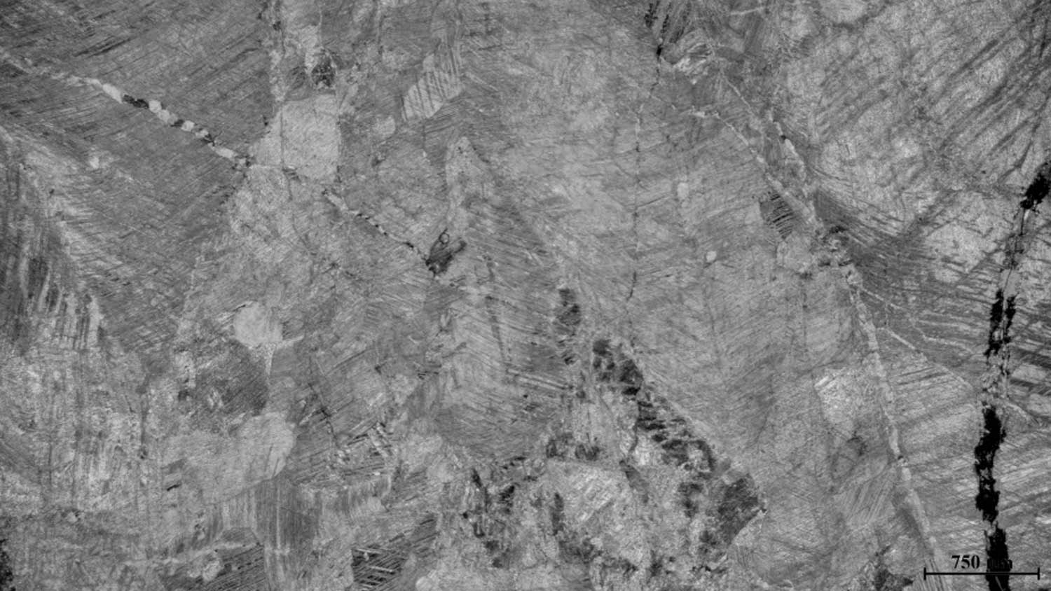
Marble from Banjska Monastery.
4.2.4 Sublitharenite
The rock is dark ochre and yellow in color. It has a psammitic structure and is porous with a rough, uneven fracture. It does not react with diluted HCl. The rock is moderately sorted, composed of semi-angular to semi-rounded grains measuring from 0.1 to 0.2 mm, rarely up to 0.5 mm. Quartz grains dominate, making up about 85% of the rock’s volume. Some grains exhibit undulatory extinction. A few quartz grains have corroded edges, and some contain inclusions of metallic minerals and/or zircon. Around 5% of the rock’s volume consists of potassium feldspar, which is mostly altered. Lithic fragments account for about 10% of the rock’s volume, and fragments of quartzite, chert, and some altered rocks are observed. Pyroxene is noted as an accessory mineral. Mica flakes (muscovite) are also visible, sometimes bending around the grains. The rock’s cement is quartz-sericitic with iron oxide impurities, both basal and contact based. The texture of the rock is massive, and the structure is psammitic. No integration was performed, and based on the estimated content of detrital components, the rock is classified as sublitharenite (Figure 11).

Sublitharenite from Banjska Monastery.
4.2.5 Church foundation – biomicrite – bioclastic wackestone to packstone
The rock is gray-brown in color. It has a microcrystalline structure with a smooth and conchoidal fracture. It reacts vigorously with diluted HCl. The bioclastic component is abundant, consisting of Globotruncana and some other foraminifera. Calcispheres are also noticeable. The bioclasts occasionally form banded accumulations. The matrix of the rock is composed of micritic material with iron oxide impurities. Concentrations of iron-rich components can only be observed sporadically in veins. Accumulations of silt-sized angular quartz grains are also noticeable (Figure 12).

Church Foundation – Biomicrite – Bioclastic Wackestone to Packstone at Banjska Monastery.
4.3 Paleontological investigations
Based on the determination of microfossils, it has been established that the samples are of Upper Cretaceous age (Santonian). The microassociation consists of planktonic foraminifera typical of a pelagic environment (open sea). In the open sea environment, without strong water movements, the microfauna lived freely in the water column. The shells of planktonic foraminifera were usually thin, spherical to globular in shape, with sculptural elements (spines and similar features) aimed at increasing the surface area of the individual. Most foraminifera, including the mentioned planktonic forms, required normal salinity for their life in marine basins, without significant fluctuations, thus belonging to the group of stenohaline organisms.
4.3.1 Red preparation
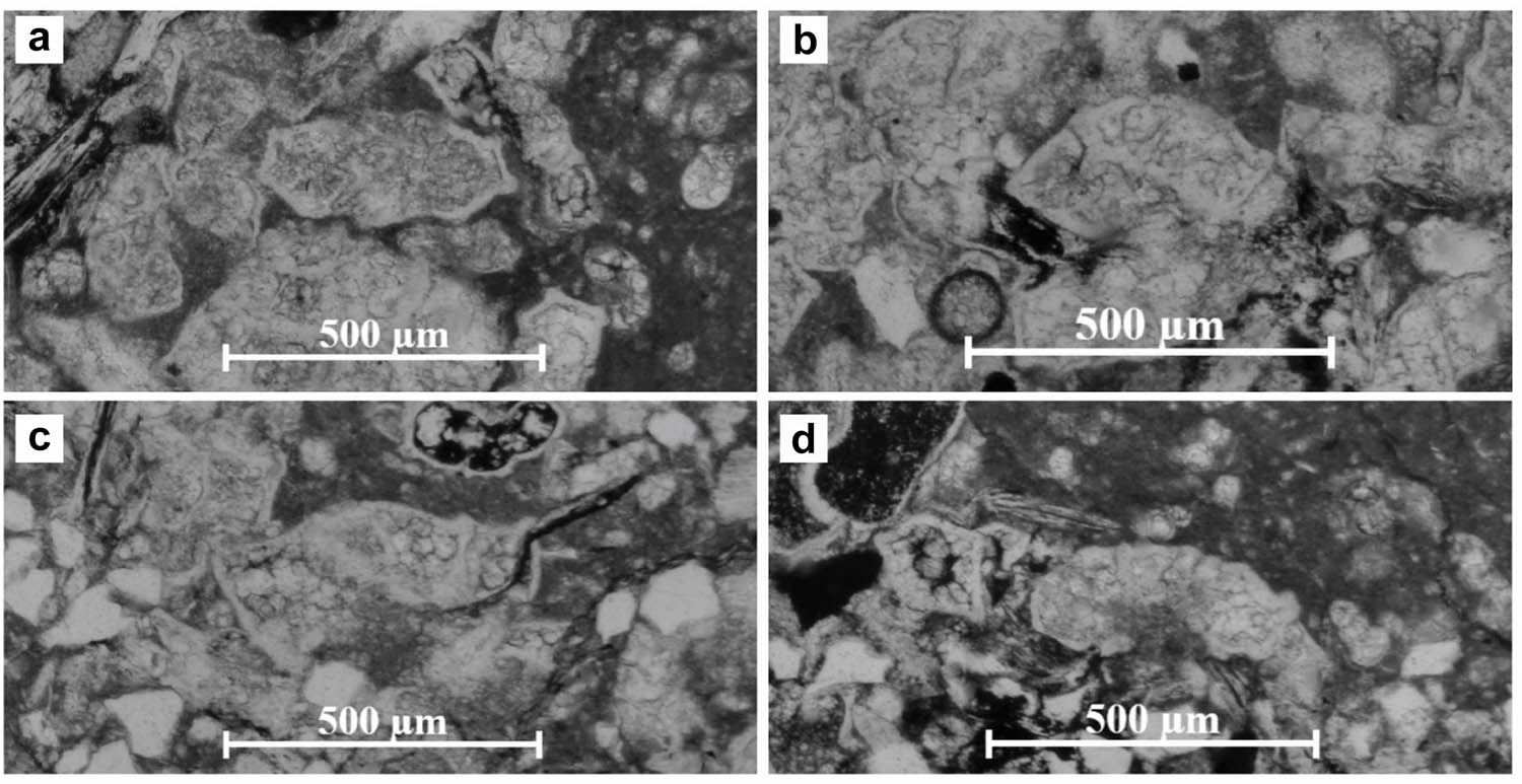
It contains numerous sections of planktonic foraminifera that are observed, some of which are concentrated in accumulations in jets. The microfossil association indicates an open sea environment (the so-called pelagial) (Figure 13). The following microfossils have been identified: Contusotruncana fornicata Plummer, Globigerinelloides, Globotruncana cf. G. lapparenti Brotzen, Globotruncana linneiana d’Orbigny, Globotruncanita elevata Brotzen, Heterohelix, Marginotruncana coronata Bolli, and Marginotruncana renzi Gandolfi. The sedimentary rock from which the red limestone sample was made is of Upper Cretaceous age (Santonian).

(a) G. elevata Brotzen; (b) M. coronata Bolli; (c) C. fornicata Plummer; and (d) M. renzi Gandolfi from the red preparation of Banjska Monastery.
4.3.2 Green preparation
The presence of microfossil sections is noted, which mainly belong to planktonic foraminifera. The environment in which these microorganisms lived is pelagic, that is, in the open sea zone without strong water movements, allowing them to float in the water column with their shells adorned with spines (Figure 14). The following forms have been determined: Calcisphaerulidae, C. fornicata Plummer, Globigerinelloides, Globotruncana arca Cushman, Globotruncana bulloides Vogler, Globotruncana hilli Pessagno, Globotruncana lapparenti Brotzen, Globotruncana gr. linneiana d’Orbigny, G. elevata Brotzen, Globotruncanita stuartiformis Dalbiez, Hedbergella sp., Heterohelix, and Marginotruncana sigali Reichel. The age of this limestone is Upper Cretaceous (Santonian).

(a) G. bulloides Vogler; (b) M. sigali Reichel; (c) G. elevata Brotzen; and (d) G. lapparenti Brotzen from the green preparation of Banjska Monastery.
4.3.3 Foundation preparation
The preparation exhibits a pelagic microassociation, which is largely found in jets as accumulations. Planktonic foraminifera are present in the open sea zone. The microfauna identified includes: Calcisphaerulidae, C. fornicata Plummer, Dicarinella sp., Globigerinelloides, G. bulloides Vogler, G. hilli Pessagno, G. lapparenti Brotzen, Globotruncana cf. G. lapparenti Brotzen, G. linneiana d’Orbigny, G. elevata Brotzen, Hedbergella sp., Heterohelix, and M. sigali Reichel (Figure 15). Based on the identified microassociation, the sediment is of Upper Cretaceous age (Santonian).
(a) G. lapparenti Brotzen; (b) M. sigali Reichel; (c) G. elevata Brotzen; and (d) G. bulloides Vogler from the foundation of Banjska Monastery.
4.4 UGAM analysis
The obtained results are presented in Tables 2 and 3, as well in Figure 16. Analysis of the total UGAM score indicates that UGVs (UGV = 170.89, min 45.88; max 229.40) and TVs (TV = 126.98, min 42.52; max 212.60) are at a moderate level, placing the site within the field U33. It is obvious that Banjska Monastery possesses natural attributes that support the dissemination of geoscientific knowledge; these attributes have not yet been adequately recognized and developed to position the site as a geotourism destination.
![Figure 16
Position of the Banjska Monastery in the UGAM matrix compared to geocultural sites Felix Romuliana [12] and Sokograd fortress [13].](/document/doi/10.1515/geo-2025-0863/asset/graphic/j_geo-2025-0863_fig_016.jpg)
4.4.1 UGVs
The evaluation results related to UGV reveal the current condition of Banjska Monastery and its potential for future urban geotourism development. The total score for this group of indicators is 170.89, with a minimum of 45.88 and a maximum of 229.40. This high score is mainly due to the monastery’s strong scientific and natural values, particularly in its geocultural, historical, and educational significance. The subindicators for geohistorical values and threats to the site each received the highest possible score of 5. The high geohistorical value reflects the monastery’s status as the endowment and burial church of King Milutin, one of medieval Serbia’s greatest rulers, and its profound spiritual importance to the Serbian people. The subindicator threats to the site also scored 5 because there are currently no significant human-induced or natural threats to the site, and plans exist to reduce human impact further. Paleo significance was rated slightly lower, with a score of 4 (total score 12.56), supported by microscopic investigations that confirmed the presence of organic matter and organism distributions that help explain paleogeographical processes, relief reconstruction, paleoclimate, and the environment in which the rocks formed. The Banjska Monastery is situated on serpentinite approximately 45 m above the Banjska River, offering attractive panoramic views of the river valley and the slopes of Rogozna Mountain. This contributes to its aesthetic value, which was rated 4 (total score 12.56). The monastery’s exterior, especially the outer south wall, features multicolored stones in yellow, red, and gray arranged in a chessboard pattern, creating a rich polychromatic appearance (Figures 1 and 5). Geocultural values also received a score of 4, reflecting the strong cultural connection between the site and its geodiversity. The monastery’s strategic position on serpentinite high above the river made it difficult for invaders to access, and its construction with locally available materials reflects the architectural style of the region and era. Ecological value was rated high (score of 4) due to the monastery’s location in the foothills of Rogozna Mountain, surrounded by largely untouched natural environments [46]. The surrounding geoheritage includes thermal springs, the Banjska River valley, and the volcanic Rogozna Mountain. Banjska Monastery is recognized as an important material cultural heritage site of Serbia and has been protected at the national level since 1947, scoring 4 points for this status. The site’s representativeness, which reflects the presence and level of geodiversity elements, scored 3, as all elements of geodiversity are observable onsite. However, the rarity score was low because many similar medieval cultural sites exist in the Ibar River valley, such as the Studenica, Žiča, and Gradac Monasteries. Finally, the site’s integrity received a slightly lower rating due to the monastery’s history of repeated destruction. Although reconstruction efforts began in 2006, they are still ongoing, which affects the completeness of the site.
4.4.2 TVs
The evaluation of TVs offers insight into the current status of various factors crucial for tourism development, such as accessibility, promotion, and infrastructure. The total score for TVs at Banjska Monastery is 126.98, with a minimum of 42.52 and a maximum of 212.60. The highest-rated subindicators are educational potential, accommodation, and restaurant services, each receiving a top score of 5. The site presents excellent opportunities for education and the dissemination of Earth sciences, with a total educational potential score of 21.55. This is supported by both microscopic and macroscopic analyses, which provide valuable geological information accessible to visitors regardless of their prior knowledge. Located within the Banjska Spa area, the monastery benefits from nearby hotel accommodation (Hotel Rajska Banja) and restaurant facilities. The visibility of geodiversity is rated high with a score of 4, as the site is well positioned and easily accessible, offering numerous viewpoints that showcase its geoheritage. Visitor safety is also rated highly, with a total score of 12.36. The site allows safe movement, with no risks of landslides or slippery surfaces, and is situated away from busy traffic routes. However, other tourism parameters received lower scores. The annual number of tourists is relatively low, with most visits motivated by pilgrimage rather than geoheritage interests. This limited visitation may be linked to insufficient promotional efforts, which are currently confined to a local level, and a lack of developed tourism infrastructure. Essential amenities such as rest areas, waste disposal facilities, toilets, and accessible pathways for people with disabilities are absent. Additionally, the absence of information boards, organized tour guide services, and an information center near the monastery or nearby settlements have resulted in these parameters receiving the lowest possible score of 1.
4.4.3 UGAM matrix
The results of the evaluation, summarized in Table 3 and Figure 16, underscore Banjska Monastery’s potential as an urban geotourism site, particularly emphasizing its geocultural, historical, and educational significance. The geosite falls within field U33, indicating medium values for both UGV and TV. The UGV reflects the site’s geological importance and its integration into the urban environment, making it valuable for scientific research and public engagement. Meanwhile, the TV assesses its potential as a tourist destination by considering factors such as accessibility, visual appeal, and visitor interest. Although Banjska Monastery does not achieve the highest scores in either category, its moderate ratings reveal a balanced potential for development into a geotourism site capable of attracting visitors while preserving its natural and cultural heritage. Further research into its unique geological features and the implementation of enhanced protection measures could increase its value and expand opportunities for sustainable tourism growth.
5 Discussion
This research identifies the geoheritage potential of Banjska Monastery and explores ways to translate it into tangible TV. While the monastery possesses significant potential for disseminating Earth science knowledge, its primary value remains tied to its strong intangible cultural, historical, and spiritual significance as a renowned pilgrimage site. The widely referenced ABC concept [11,13,47,48], which integrates abiotic, biotic, and cultural components of an area, is fully embodied by Banjska Monastery, offering a unique combination that can be leveraged to enhance tourism potential.
Among the UGAM subindicators, the educational potential of urban geosites carries one of the highest importance factors (Im) for Serbian tourists, underscoring the need to prioritize geoheritage interpretation. This is particularly relevant to the heritage stones used in the monastery’s construction and the site’s strategic placement within a landscape shaped by local landforms and topography. Similar themes have been explored in prior studies on cultural heritage and geoheritage integration [49,50,51,52]. The petrographic characteristics of Banjska Monastery’s building stones contribute notably to its geotourism appeal. The site exhibits considerable petrodiversity, encompassing multiple petrographic types, which positively influenced the natural value indicators in the UGAM assessment. Furthermore, these petrographic data informed the geohistorical value subindicator, highlighting the link between geodiversity and the monastery’s historical context. This connection not only reveals the role of geodiversity in the urban spatial development of the site but also offers a pathway to deepen visitors’ appreciation of the region’s geotectonic evolution and the relationship between local geology and construction materials. Paleontological investigations further enhanced the assessment of the site’s paleo-significance by revealing the environmental conditions under which the building stones were formed. Such insights could be effectively incorporated into educational geotrails [53], geocultural routes [54], or on-site geoeducational workshops aimed at university geoscience students and the broader public interested in Earth sciences [55]. Certain rock types, such as sandstone, act as natural outdoor museums by preserving visible geological features – for example, cracks indicating sun-drying events and bedding marks that document historical sediment deposition patterns [13]. Numerous studies emphasize the importance of interpreting geoheritage related to building stones, including rock types, genesis, provenance, extraction methods, fossil content, texture, structure, and their roles in construction and architecture [3,12,56,57,58,59]. Microscopic analyses of the Banjska Monastery’s stones could be summarized in brochures or leaflets to facilitate onsite visual interpretation of the building materials. This information would also be valuable for future restoration efforts, guiding the selection of appropriate rock types and characteristics. Comparing the results of this study with the dataset provided by Bogdanović et al. [60] was instrumental in identifying the local provenance of the building stones, confirming that the materials were sourced from the surrounding geological formations widely distributed in the area.
To enhance promotional activities, increase the visibility of the Banjska Monastery, and strengthen its educational potential, the implementation of various digital promotion tools is essential. One effective approach would be the development of a mobile application for both Android and iOS platforms, as such apps have proven to be among the most intelligent and efficient means of promoting geotourism to a wide audience [61]. Successful examples of geotourism promotion through mobile applications can be found in locations like the Sesia Val Grande UNESCO Global Geopark [62], Torino [63], Rome [4], and the Molise Region [61] in Italy, as well as Lausanne [64] in Switzerland. These applications provide access to geotrails, nearby geosites, virtual tours, and incorporate advanced technologies such as augmented reality (AR) and virtual reality (VR) to enrich visitor experiences. They also deliver information about the connections between cultural and geological heritage and offer diverse promotional activities tailored to varied audience interests. Complementing a mobile app, the development of a multilingual web platform and digital audio guides would further supply vital tourist information and address the current lack of onsite visitor support.
Two additional studies have applied the UGAM model to geocultural sites in Serbia: the archaeological site Felix Romuliana near Zaječar [12] and Sokograd Fortress near Sokobanja [13]. When comparing the Banjska Monastery (UGV = 170.89; TV = 126.98) with Felix Romuliana (UGV = 145.78; TV = 171.78) and Sokograd Fortress (UGV = 137.47; TV = 129.08), all three sites fall within the U33 field. However, notable differences exist in specific indicator values. Banjska Monastery shows higher scientific values, particularly in paleo-significance, geohistorical, and geocultural aspects, as well as superior natural values such as aesthetic appeal and geodiversity variety, compared to the other two sites. In contrast, Felix Romuliana exhibits somewhat higher protection values, including better preservation and carrying capacity, alongside significantly higher TV. This is largely due to its established reputation as a tourist destination, supported by developed infrastructure, guided tours, active promotional efforts, and information panels. To keep pace with contemporary geotourism trends, such as educational guided tours, AR- or QR code-enabled information boards for self-guided visits, and audio guides, the Banjska Monastery would benefit greatly from enhancements in infrastructure and promotion, helping to convert its strong natural and scientific values into increased tourism appeal.
While increasing the number of visitors is a key goal of tourism development, it is essential to consider sustainable development principles, ecological capacity, and carrying capacity to protect the site’s integrity. Modern approaches that support sustainable development and geoconservation – such as remote sensing technologies including drones and satellite imagery – can provide valuable data for monitoring tourist numbers and detecting damage, especially in areas that are difficult to access [65]. Additionally, the use of geographic information systems (GIS) offers a powerful tool for the efficient management and sophisticated spatial analysis of data. GIS can assist local policymakers and stakeholders in transforming natural values into tourism assets, significantly improving land-use planning and the evaluation of geotourism development strategies [66].
Further research should prioritize sustainable development and include a thorough assessment of degradation risks, as increased tourism may threaten key elements of the site such as its aesthetic, spiritual, and cultural values. A degradation risk assessment has been successfully conducted at the geocultural site of Sokograd [13], identifying vulnerable areas that require careful management during tourism development. Implementing a similar risk assessment model at the Banjska Monastery would help safeguard its invaluable heritage while allowing for responsible tourism growth. Further development of the UGAM could incorporate advanced GIS functionalities and cloud-based platforms to streamline and accelerate the evaluation process, particularly for subindicators like surface area calculation, carrying capacity, and visitor safety (e.g., landslide risk), which are critical for sites with challenging access.
This study has certain limitations. The macroscopic and microscopic investigations were conducted only on the most common and visually accessible building stones of the Banjska Monastery, rather than on all stone types used in its construction. Additionally, due to the sensitive political situation in the region, on-site investigations of the surrounding area to identify natural outcrops matching the characteristics of the building stones were not feasible. Consequently, comparisons were limited to available literature sources, such as geological maps [60].
6 Conclusions
This article aims to estimate the geotourism potential of the Banjska Monastery and explore ways to convert its natural value into TV. The application of the UGAM model for evaluating urban geosites provided valuable insights into the benefits, challenges, limitations, and opportunities for developing urban geotourism at the Banjska Monastery. Based on the obtained results, the following conclusions can be drawn:
A mineralogical-petrographical analysis of selected building stones at the Banjska Monastery reveals significant petrographical diversity. The construction materials include genetically distinct rock types, comprising sedimentary rocks (limestone, sandstone, and tufa) as well as metamorphic rocks (marble).
A detailed analysis of microfacies, composition, and rock structure was conducted, based on which the environments of sediment formation were determined. Biomicrites, according to their characteristics and fossil association, originated in a deep-water marine environment. This environment was close to the boundary of the photic zone, as indicated by the accumulation of fossil content due to deposition. Sublitharenites formed in areas with strong erosion, likely related to a deep-water marine environment and turbidity currents. Marble was formed by the regional metamorphism of sparry calcite (grainstone).
This study also provides a description of the micropaleontological findings of three limestone samples collected for the purposes of the Banjska Monastery. The samples were analyzed using thin sections and studied under a microscope to examine the microfauna, primarily planktonic foraminifera, which indicate an Upper Cretaceous age (Santonian). All samples belong to a pelagic environment, meaning the microfossils were found in open marine conditions with stable salinity.
UGAM parameters related to scientific and natural values are relatively high, especially for geocultural and geohistorical significance, as well as for ecological values and aesthetic appeal. These parameters are important as they provide the basis for tourism development. On the other hand, the site has a low score for TVs, particularly for promotional activities, information boards, tour guide services, and information centers.
This information offers valuable guidance for future tourism development, enabling stakeholders, policymakers, and local authorities to incorporate it into management plans. Similar research should be conducted at other nearby geocultural sites, facilitating the creation of thematic geocultural routes to showcase the region’s heritage.
Based on the analysis, the Banjska Monastery holds significant tourist appeal. The site offers diverse opportunities for various forms of motivated movement, with particular potential for cultural tourism and active recreation. This should be the focal point for future tourism development in the area. The combination of a healthy, well-preserved natural environment and rich archaeological and cultural heritage makes the wider Banjska Monastery region highly valuable from a tourism standpoint. To fully realize this potential, appropriate infrastructure development is essential. Emphasis should be placed on expanding complementary accommodation facilities and encouraging the growth of private lodging owned by the local community, integrating seamlessly with the Banjska environment. This approach would allow local stakeholders to offer visitors authentic experiences that combine cultural heritage exploration with opportunities for active recreation.
Acknowledgments
The authors are grateful to monks of Banjska Monastery for providing valuable information on the monastery and its history.
-
Funding information: This research was partially funded by the Provincial Secretariat for Higher Education and Scientific Research of the Autonomous Province of Vojvodina, Republic of Serbia (Grant No. 142-451 3490/2023). SM is grateful to Silesian Technical University. This research was supported by Project F-178 of the Serbian Academy of Sciences and Arts. MGR is grateful for the L’Oréal-UNESCO for Women in Science award. The authors acknowledge the support of the Ministry of Sciences, Technological Development, and Innovations, Republic of Serbia (451-03-65/2024-03/200123). The authors acknowledge the support of the Program of Cooperation with the Serbian Scinetific Diaspora – Joint Research Project – DIASPORA 2023, from the Science Fund of the Republic of Serbia, under the project LAMINATION (The Loess Plateau Margins: Towards Innovative Sustainable Conservation), project number: 17807 (451-03-136/2025-03/200124; 451-03-137/2025-03/200124).
-
Author contributions: NB and MM set the draft of the manuscript; MGR, MN, DR, DB, RM, AR, and NT helped in the interpretation of obtained results; and MM, MGR, SBM, TT, TL, and DS did field research and final appearance of the manuscript.
-
Conflict of interest: The authors state no conflict of interest.
-
Data availability statement: The datasets generated during and/or analysed during the current study are available from the corresponding author on reasonable request.
-
Statement: This manuscript (or one with substantially the same content, by any of the authors) has not been previously published in any language anywhere, and it is not under simultaneous consideration or in press by another journal.
-
Status of article: It is a new research article, Special Issue: Geospatial and Environmental Dynamics.
References
[1] Štrba Ľ, Vravcová A, Podoláková M, Varcholová L, Kršák B. Linking geoheritage or geosite assessment results with geotourism potential and development: a literature review. Sustainability. 2023;15(12):9539.10.3390/su15129539Search in Google Scholar
[2] Brilha J. Inventory and quantitative assessment of geosites and geodiversity sites: a review. Geoheritage. 2016;8(2):119–34.10.1007/s12371-014-0139-3Search in Google Scholar
[3] Del Lama EA, de La Corte Bacci D, Martins L, da Glória Motta Garcia M, Dehira LK. Urban geotourism and the old centre of São Paulo City. Braz Geoheritage. 2015;7(2):147–64.10.1007/s12371-014-0119-7Search in Google Scholar
[4] Pica A, Vergari F, Fredi P, Del Monte M. The aeterna urbs geomorphological heritage (Rome, Italy). Geoheritage. 2016;8:31–42.10.1007/s12371-015-0150-3Search in Google Scholar
[5] Habibi T, Ponedelnik AA, Yashalova NN, Ruban DA. Urban geoheritage complexity: Evidence of a unique natural resource from Shiraz city in Iran. Resour Policy. 2018;59:85–94.10.1016/j.resourpol.2018.06.002Search in Google Scholar
[6] Del Lama EA. Potential for urban geotourism: churches and cemeteries. Geoheritage. 2019;11(3):717–28.10.1007/s12371-018-0325-9Search in Google Scholar
[7] Palacio-Prieto JL. Geoheritage within cities: urban geosites in Mexico City. Geoheritage. 2015;7(4):365–73.10.1007/s12371-014-0136-6Search in Google Scholar
[8] Chylińska D, Kołodziejczyk K. Geotourism in an urban space? Open Geosci. 2018;10(1):297–310.10.1515/geo-2018-0023Search in Google Scholar
[9] Kubalíková L, Kirchner K, Kuda F, Bajer A. Assessment of urban geotourism resources: an example of two geocultural sites in Brno, Czech Republic. Geoheritage. 2020;12(1):1–12.10.1007/s12371-020-00434-xSearch in Google Scholar
[10] Kubalíková L, Zapletalová D. Geo-cultural aspects of building stone extracted within Brno city (Czech Republic): A bridge between natural and cultural heritage. Geoheritage. 2021;13(3):78.10.1007/s12371-021-00585-5Search in Google Scholar
[11] Pijet-Migoń E, Migoń P. Geoheritage and cultural heritage—a review of recurrent and interlinked themes. Geosciences. 2022;12(2):98.10.3390/geosciences12020098Search in Google Scholar
[12] Marjanović M, Marković R, Šarić K, Radivojević AR, Antić A, Raičević Đ, et al. Geotouristic Approach to the elements of geocultural heritage by using UGAM Model: UNESCO World Heritage Site Felix Romuliana (Zaječar, Serbia). Geoheritage. 2024;16(2):1–21.10.1007/s12371-024-00940-2Search in Google Scholar
[13] Marjanović M, Marković R, Radivojević A, Tomić N, Radaković MG, Spalević V, et al. Urban geoheritage and degradation risk assessment of the Sokograd fortress (Sokobanja, Eastern Serbia). Open Geosci. 2024;16(1):20220681.10.1515/geo-2022-0681Search in Google Scholar
[14] Bonnot-Courtois C, Walter-Simonnet AV, Baltzer A. The mont-saint-michel bay: an exceptional megatidal environment influenced by natural evolution and man-made modifications. In: Fort M, André MF, editors. Landscapes and landforms of france. world geomorphological landscapes. Dordrecht: Springer; 2014. 10.1007/978-94-007-7022-5_5.Search in Google Scholar
[15] Franchi R, Savelli D, Colosi F, Drapp P, Gabrielli R, Moretti E, et al. Petra and Beida (Jordan): Two adjacent archaeological sites up to an exploitation of geomorphology-related topics for a cultural and touristic development. Mem Descr Carta Geol D’It. 2009;87:77–90.Search in Google Scholar
[16] Zafeiropoulos G, Drinia H. GEOAM: a holistic Assessment Tool for unveiling the Geoeducational potential of Geosites. Geosciences. 2023;13(7):210.10.3390/geosciences13070210Search in Google Scholar
[17] Henriques MH, Dos Reis RP, Brilha J, Mota T. Geoconservation as an emerging geoscience. Geoheritage. 2011;3:117–28.10.1007/s12371-011-0039-8Search in Google Scholar
[18] Peppoloni S, Di Capua G. The meaning of geoethics. Geoethics: ethical challenges and case studies in earth sciences. Amsterdam, The Netherlands: Elsevier; 2015. p. 3–1410.1016/B978-0-12-799935-7.00001-0Search in Google Scholar
[19] Mosios S, Georgousis E, Drinia H. The status of geoethical thinking in the educational system of greece: an overview. Geosciences. 2023;13(2):37.10.3390/geosciences13020037Search in Google Scholar
[20] Suzuki DA, Takagi H. Evaluation of geosite for sustainable planning and management in geotourism. Geoheritage. 2018;10:123–35.10.1007/s12371-017-0225-4Search in Google Scholar
[21] Ruban DA. Quantification of geodiversity and its loss. Proc Geol Assoc. 2010;121:326–33.10.1016/j.pgeola.2010.07.002Search in Google Scholar
[22] Tomić N. The potential of Lazar Canyon (Serbia) as a geotourism destination: inventory and evaluation. Geogr Pannonica. 2011;15(3):103–12.10.5937/GeoPan1103103TSearch in Google Scholar
[23] Tomić N, Božić S. A modified geosite assessment model (MGAM) and its application on the Lazar Canyon area (Serbia). Int J Environ Res. 2014;8(4):1041–52.Search in Google Scholar
[24] Melelli L. Geodiversity: a new quantitative index for natural protected areas enhancement. Geoj Tour Geosites. 2014;13(1):27–37.Search in Google Scholar
[25] Kot R. The point bonitation method for evaluating geodiversity: a guide with examples (Polish Lowland). Geogr Ann: Ser A Phys Geogr. 2015;97(2):375–93.10.1111/geoa.12079Search in Google Scholar
[26] Kubalíková L, Kirchner K. Geosite and geomorphosite assessment as a tool for geoconservation and geotourism purposes: a case study from Vizovická vrchovina Highland (eastern part of the Czech Republic). Geoheritage. 2016;8(1):5–14.10.1007/s12371-015-0143-2Search in Google Scholar
[27] Mikhailenko AV, Nazarenko OV, Ruban DA, Zayats PP. Aestheticsbased classification of geological structures in outcrops for geotourismpurposes: a tentative proposal. Geologos. 2017;23:45–52.10.1515/logos-2017-0004Search in Google Scholar
[28] Forte JP, Brilha J, Pereira DI, Nolasco M. Kernel density applied to the quantitative assessment of geodiversity. Geoheritage. 2018;10:205–17.10.1007/s12371-018-0282-3Search in Google Scholar
[29] Antić A, Tomić N, Marković SB. Applying the show cave assessment model (SCAM) on cave tourism destinations in Serbia. Int J Geoheritage Park. 2022;10(4):616–34.10.1016/j.ijgeop.2022.10.001Search in Google Scholar
[30] Petrović R. Monogrami kralja Stefana Upoša II Milutina y Gračanici. Monogrammes des rois Stéphane Uroš II Milutin à Gračanica. Institute for the Protection of Cultural Monuments of Serbia – Belgrade. Communications. 1981;13:1–12.Search in Google Scholar
[31] Korać VR. Smisao građenja po uzoru-primeri u srpskoj arhitekturi XIV veka (The meaning of building according to a model-example in Serbian architecture of the 14th century). Zbornik radova Vizantološkog instituta. 2004;41:205–12.10.2298/ZRVI0441205KSearch in Google Scholar
[32] Vujović M, Vuković J. Jedno nepoznato svedočanstvo iz ratne 1915. godine: prvo iskopavanje manastira Banjske (One unknown testimony from the war year 1915: the first excavation of the Banjska monastery). Vesn Vojnog muzeja. 2016;43:39–52.Search in Google Scholar
[33] Todorović D. Sarcophagus with Inscription from Banjska. Communications. 2022;54:157–67. https://doi.org/10.18485/rzzsk_saopstenja.2022.54.6 Search in Google Scholar
[34] Popović D. Grob kraljice Teodore u Manastiru Banjska – Još jedno preispitivanje (The tomb of Queen Theodora in the Banjska Monastery-Another review). Zbornik Radova Vizantološkog Instituta. 2023;60(2):1077. https://doi.org/10.2298/ZRVI2360041P Search in Google Scholar
[35] Bošković Đ. Izveštaj o proučavanju spomenika (Report on the study of monuments). Godišnjak Srpske kraljevske akademije. 1929;37:215–8.Search in Google Scholar
[36] Samardžić GM. The problem of ubication of the Vellanis, Vindenae road stop Ad Fines Lisus-Naisus road (Up Moesia). Zbornik radova Filozofskog fakulteta u Prištini. 2021;51(2):211–23.10.5937/ZRFFP51-32664Search in Google Scholar
[37] Ministry for environmental protection, Digital climate and climate change atlas of the republic of Serbia. Project, Advancing medium and long-term adaptation planning in the republic of Serbia “. 2022. https://atlas-klime.eko.gov.rs Search in Google Scholar
[38] http://www.arcgis.com/home/item.html? id = 30e5fe3149c34df1ba922e6f5bbf808f. (September 28, 2024).Search in Google Scholar
[39] Mladenović A, Trivić B, Cvetković V. How tectonics controlled post-collisional magmatism within the Dinarides: Inferences based on study of tectono-magmatic events in the Kopaonik Mts.(Southern Serbia). Tectonophysics. 2015;646:36–49.10.1016/j.tecto.2015.02.001Search in Google Scholar
[40] Šoštarić SB, Cvetković V, Neubauer F, Palinkaš LA, Bernroider M, Genser J. Oligocene shoshonitic rocks of the Rogozna Mts.(Central Balkan Peninsula): Evidence of petrogenetic links to the formation of Pb–Zn–Ag ore deposits. Lithos. 2012;148:176–95.10.1016/j.lithos.2012.05.028Search in Google Scholar
[41] Monthel J, Vadala P, Leistel JM, Cottard F, Ilic M, Strumberger A, et al. Mineral deposits and mining districts of Serbia. Compilation map and GIS databases. Ministry of mining and energy of Serbia. Belgrade: Geoinstitut; 2002.Search in Google Scholar
[42] Marjanović M, Tomić N, Radivojević AR, Marković SB. Assessing the geotourism potential of the Niš city area (Southeast Serbia). Geoheritage. 2021;13:1–18.10.1007/s12371-021-00597-1Search in Google Scholar
[43] Marjanović M, Radivojević AR, Antić A, Peppoloni S, Di Capua G, Lazarević J, et al. Geotourism and geoethics as support for rural development in the Knjaževac municipality, Serbia. Open Geosci. 2022;14(1):794–812.10.1515/geo-2022-0388Search in Google Scholar
[44] Antić A, Radaković MG, Marjanović M, Marković SB, Perić ZM, Spalević V, et al. Loess and geotourism potential of the Braničevo District (NE Serbia): From overexploitation to paleoclimate interpretation. Open Geosci. 2023;15(1):20220546.10.1515/geo-2022-0546Search in Google Scholar
[45] Marković SB, Schaetzl RJ, Sprafke T, Antić A, Ćirić V, Radaković MG, et al. The Geoheritage Value of Chernozem Soils (Black Soils) and Their Equivalents from the Thick Loess Sections in the Vojvodina Region, Northern Serbia. Geoheritage. 2025;17(1):19.10.1007/s12371-024-01057-2Search in Google Scholar
[46] Papović O, Miljković M, Ranđelović N, Ranđelović V. Analysis of the flora of Rogozna Mountain in Southwestern Serbia. Biol Nyssana. 2014;5(1):17–30.Search in Google Scholar
[47] Pásková M, Zelenka J, Ogasawara T, Zavala B, Astete I. The ABC concept—value added to the Earth heritage interpretation? Geoheritage. 2021;13:1–25.10.1007/s12371-021-00558-8Search in Google Scholar
[48] Migoń P, Pijet-Migoń E. Non-uniform distribution of geoheritage resources in geoparks—problems, challenges and opportunities. Resour. 2024;13(2):23.10.3390/resources13020023Search in Google Scholar
[49] Reynard E, Pica A, Coratza P. Urban geomorphological heritage. An Overview. Quaest Geogr. 2017;36:7–20.10.1515/quageo-2017-0022Search in Google Scholar
[50] Vaz T, Zêzere JL. The urban geomorphological landscape of Lisbon. In: Vieira G, Zêzere JL, Mora C, editors. Landscapes and landforms of Portugal. Cham, Switzerland: Springer; 2020. p. 295–303.10.1007/978-3-319-03641-0_23Search in Google Scholar
[51] Pelfini M, Brandolini F, D’Archi S, Pellegrini L, Bollati I. Papia civitas gloriosa: Urban geomorphology for a thematic itinerary on geocultural heritage in Pavia (Central Po Plain, N Italy). J Med Aromat Plant Sci. 2021;17:42–50.10.1080/17445647.2020.1736198Search in Google Scholar
[52] Fernandes NF, Tupinambá M, Mello CL, Peixoto MN. Rio de Janeiro: A metropolis between granite-gneiss massifs. In Geomorphological Landscapes of the World; Migo´ n, P., Ed. Dordrecht, The Netherlands: Springer; 2010. p. 89–100.10.1007/978-90-481-3055-9_10Search in Google Scholar
[53] Hose TA. Geotrails. Geotourism In 21st Century. New York, USA: Apple Academic Press; 2020. p. 247–75.10.1201/9780429292798-13Search in Google Scholar
[54] Antić A, Tomić N, Đorđević T, Marković SB. Promoting palaeontological heritage of mammoths in Serbia through a cross-country thematic route. Geoheritage. 2021;13:1–16.10.1007/s12371-021-00530-6Search in Google Scholar
[55] Melelli L. “Perugia upside-down”: a multimedia exhibition in Umbria (Central Italy) for improving geoheritage and geotourism in urban areas. Resources. 2020;8(3):148.10.3390/resources8030148Search in Google Scholar
[56] Fio Firi K, Maričić A. Usage of the natural stones in the City of Zagreb (Croatia) and its geotouristical aspect. Geoheritage. 2020;12:62. 10.1007/s12371-020-00488-x.Search in Google Scholar
[57] Melelli L, Silvani F, Ercoli M, Pauselli C, Tosi G, Radicioni F. Urban geology for the enhancement of the hypogean geosites: The Perugia underground (Central Italy). Geoheritage. 2021;13(1):1–20.10.1007/s12371-021-00545-zSearch in Google Scholar
[58] Kong W, Li Y, Li K, Chen M, Peng Y, Wang D, et al. Urban geoheritage sites under strong anthropogenic pressure: example from the chaohu Lake Region, Hefei, China. Geoheritage. 2020;12(3):1–24.10.1007/s12371-020-00490-3Search in Google Scholar
[59] Zoboli D, Pistis M, Afrasinei GM, Nonnoi G, Pillola GL. Crocodiles, sharks and turtles: The urban geo-palaeontological heritage of Cagliari (Italy). Geoheritage. 2021;13(3):52.10.1007/s12371-021-00580-wSearch in Google Scholar
[60] Bogdanović P, Urošević M, Urošević D, Dimitrijević M, Marković B, Pavić A, et al. Explanator book for sheet Titova Mitrovica. Basic geological map 1:100 000. Federal geological survey. Belgrade. 1982;1:1–56.Search in Google Scholar
[61] Filocamo F, Di Paola G, Mastrobuono L, Rosskopf CM. MoGeo, a mobile application to promote geotourism in molise region (southern Italy). Resources. 2020;9(3):31. 10. 3390/resources9 030031.Search in Google Scholar
[62] Perotti L, Bollati IM, Viani C, Zanoletti E, Caironi V, Pelfini M, et al. Fieldtrip and virtual tours as geotourism resources: example from the Sesia Val Grande UNESCO Global Geopark (NW Italy). Resources. 2020;9(6):63. 10. 3390/resou rces9 060063.Search in Google Scholar
[63] Gambino F, Borghi A, d’Atri A, Gallo LM, Ghiraldi L, Giardino M, et al. TOURin- STONES: a free mobile application for promoting geological heritage in the city of Torino (NW Italy). Geoheritage. 2019;11:3–17.10.1007/s12371-017-0277-5Search in Google Scholar
[64] Reynard E, Kaiser C, Martin S, Regolini G. An application for geosciences communication by smartphones and tablets. In: Lollino G, Giordan D, Marunteanu C, Christaras B, Yoshinori I, Margottini C, editors. Engineering geology for society and territory. Vol. 8, Heidelberg: Springer; 2025. p. 265–8. 10. 1007/978-3- 319- 09408-3_ 46.Search in Google Scholar
[65] Rutherford J, Kobryn H, Newsome D. A case study in the evaluation of geotourism potential through geographic information systems: application in a geology-rich island tourism hotspot. Curr Issues Tour. 2015;18(3):267–85.10.1080/13683500.2013.873395Search in Google Scholar
[66] Marinoni O. Implementation of the analytical hierarchy process with VBA in ArcGIS. Comp Geosci. 2004;30:637–46. 10. 1016/j. cageo. 2004. 03. 010.Search in Google Scholar
© 2025 the author(s), published by De Gruyter
This work is licensed under the Creative Commons Attribution 4.0 International License.
Articles in the same Issue
- Research Articles
- Seismic response and damage model analysis of rocky slopes with weak interlayers
- Multi-scenario simulation and eco-environmental effect analysis of “Production–Living–Ecological space” based on PLUS model: A case study of Anyang City
- Remote sensing estimation of chlorophyll content in rape leaves in Weibei dryland region of China
- GIS-based frequency ratio and Shannon entropy modeling for landslide susceptibility mapping: A case study in Kundah Taluk, Nilgiris District, India
- Natural gas origin and accumulation of the Changxing–Feixianguan Formation in the Puguang area, China
- Spatial variations of shear-wave velocity anomaly derived from Love wave ambient noise seismic tomography along Lembang Fault (West Java, Indonesia)
- Evaluation of cumulative rainfall and rainfall event–duration threshold based on triggering and non-triggering rainfalls: Northern Thailand case
- Pixel and region-oriented classification of Sentinel-2 imagery to assess LULC dynamics and their climate impact in Nowshera, Pakistan
- The use of radar-optical remote sensing data and geographic information system–analytical hierarchy process–multicriteria decision analysis techniques for revealing groundwater recharge prospective zones in arid-semi arid lands
- Effect of pore throats on the reservoir quality of tight sandstone: A case study of the Yanchang Formation in the Zhidan area, Ordos Basin
- Hydroelectric simulation of the phreatic water response of mining cracked soil based on microbial solidification
- Spatial-temporal evolution of habitat quality in tropical monsoon climate region based on “pattern–process–quality” – a case study of Cambodia
- Early Permian to Middle Triassic Formation petroleum potentials of Sydney Basin, Australia: A geochemical analysis
- Micro-mechanism analysis of Zhongchuan loess liquefaction disaster induced by Jishishan M6.2 earthquake in 2023
- Prediction method of S-wave velocities in tight sandstone reservoirs – a case study of CO2 geological storage area in Ordos Basin
- Ecological restoration in valley area of semiarid region damaged by shallow buried coal seam mining
- Hydrocarbon-generating characteristics of Xujiahe coal-bearing source rocks in the continuous sedimentary environment of the Southwest Sichuan
- Hazard analysis of future surface displacements on active faults based on the recurrence interval of strong earthquakes
- Structural characterization of the Zalm district, West Saudi Arabia, using aeromagnetic data: An approach for gold mineral exploration
- Research on the variation in the Shields curve of silt initiation
- Reuse of agricultural drainage water and wastewater for crop irrigation in southeastern Algeria
- Assessing the effectiveness of utilizing low-cost inertial measurement unit sensors for producing as-built plans
- Analysis of the formation process of a natural fertilizer in the loess area
- Machine learning methods for landslide mapping studies: A comparative study of SVM and RF algorithms in the Oued Aoulai watershed (Morocco)
- Chemical dissolution and the source of salt efflorescence in weathering of sandstone cultural relics
- Molecular simulation of methane adsorption capacity in transitional shale – a case study of Longtan Formation shale in Southern Sichuan Basin, SW China
- Evolution characteristics of extreme maximum temperature events in Central China and adaptation strategies under different future warming scenarios
- Estimating Bowen ratio in local environment based on satellite imagery
- 3D fusion modeling of multi-scale geological structures based on subdivision-NURBS surfaces and stratigraphic sequence formalization
- Comparative analysis of machine learning algorithms in Google Earth Engine for urban land use dynamics in rapidly urbanizing South Asian cities
- Study on the mechanism of plant root influence on soil properties in expansive soil areas
- Simulation of seismic hazard parameters and earthquakes source mechanisms along the Red Sea rift, western Saudi Arabia
- Tectonics vs sedimentation in foredeep basins: A tale from the Oligo-Miocene Monte Falterona Formation (Northern Apennines, Italy)
- Investigation of landslide areas in Tokat-Almus road between Bakımlı-Almus by the PS-InSAR method (Türkiye)
- Predicting coastal variations in non-storm conditions with machine learning
- Cross-dimensional adaptivity research on a 3D earth observation data cube model
- Geochronology and geochemistry of late Paleozoic volcanic rocks in eastern Inner Mongolia and their geological significance
- Spatial and temporal evolution of land use and habitat quality in arid regions – a case of Northwest China
- Ground-penetrating radar imaging of subsurface karst features controlling water leakage across Wadi Namar dam, south Riyadh, Saudi Arabia
- Rayleigh wave dispersion inversion via modified sine cosine algorithm: Application to Hangzhou, China passive surface wave data
- Fractal insights into permeability control by pore structure in tight sandstone reservoirs, Heshui area, Ordos Basin
- Debris flow hazard characteristic and mitigation in Yusitong Gully, Hengduan Mountainous Region
- Research on community characteristics of vegetation restoration in hilly power engineering based on multi temporal remote sensing technology
- Identification of radial drainage networks based on topographic and geometric features
- Trace elements and melt inclusion in zircon within the Qunji porphyry Cu deposit: Application to the metallogenic potential of the reduced magma-hydrothermal system
- Pore, fracture characteristics and diagenetic evolution of medium-maturity marine shales from the Silurian Longmaxi Formation, NE Sichuan Basin, China
- Study of the earthquakes source parameters, site response, and path attenuation using P and S-waves spectral inversion, Aswan region, south Egypt
- Source of contamination and assessment of potential health risks of potentially toxic metal(loid)s in agricultural soil from Al Lith, Saudi Arabia
- Regional spatiotemporal evolution and influencing factors of rural construction areas in the Nanxi River Basin via GIS
- An efficient network for object detection in scale-imbalanced remote sensing images
- Effect of microscopic pore–throat structure heterogeneity on waterflooding seepage characteristics of tight sandstone reservoirs
- Environmental health risk assessment of Zn, Cd, Pb, Fe, and Co in coastal sediments of the southeastern Gulf of Aqaba
- A modified Hoek–Brown model considering softening effects and its applications
- Evaluation of engineering properties of soil for sustainable urban development
- The spatio-temporal characteristics and influencing factors of sustainable development in China’s provincial areas
- Application of a mixed additive and multiplicative random error model to generate DTM products from LiDAR data
- Gold vein mineralogy and oxygen isotopes of Wadi Abu Khusheiba, Jordan
- Prediction of surface deformation time series in closed mines based on LSTM and optimization algorithms
- 2D–3D Geological features collaborative identification of surrounding rock structural planes in hydraulic adit based on OC-AINet
- Spatiotemporal patterns and drivers of Chl-a in Chinese lakes between 1986 and 2023
- Land use classification through fusion of remote sensing images and multi-source data
- Nexus between renewable energy, technological innovation, and carbon dioxide emissions in Saudi Arabia
- Analysis of the spillover effects of green organic transformation on sustainable development in ethnic regions’ agriculture and animal husbandry
- Factors impacting spatial distribution of black and odorous water bodies in Hebei
- Large-scale shaking table tests on the liquefaction and deformation responses of an ultra-deep overburden
- Impacts of climate change and sea-level rise on the coastal geological environment of Quang Nam province, Vietnam
- Reservoir characterization and exploration potential of shale reservoir near denudation area: A case study of Ordovician–Silurian marine shale, China
- Seismic prediction of Permian volcanic rock reservoirs in Southwest Sichuan Basin
- Application of CBERS-04 IRS data to land surface temperature inversion: A case study based on Minqin arid area
- Geological characteristics and prospecting direction of Sanjiaoding gold mine in Saishiteng area
- Research on the deformation prediction model of surrounding rock based on SSA-VMD-GRU
- Geochronology, geochemical characteristics, and tectonic significance of the granites, Menghewula, Southern Great Xing’an range
- Hazard classification of active faults in Yunnan base on probabilistic seismic hazard assessment
- Characteristics analysis of hydrate reservoirs with different geological structures developed by vertical well depressurization
- Estimating the travel distance of channelized rock avalanches using genetic programming method
- Landscape preferences of hikers in Three Parallel Rivers Region and its adjacent regions by content analysis of user-generated photography
- New age constraints of the LGM onset in the Bohemian Forest – Central Europe
- Characteristics of geological evolution based on the multifractal singularity theory: A case study of Heyu granite and Mesozoic tectonics
- Soil water content and longitudinal microbiota distribution in disturbed areas of tower foundations of power transmission and transformation projects
- Oil accumulation process of the Kongdian reservoir in the deep subsag zone of the Cangdong Sag, Bohai Bay Basin, China
- Investigation of velocity profile in rock–ice avalanche by particle image velocimetry measurement
- Optimizing 3D seismic survey geometries using ray tracing and illumination modeling: A case study from Penobscot field
- Sedimentology of the Phra That and Pha Daeng Formations: A preliminary evaluation of geological CO2 storage potential in the Lampang Basin, Thailand
- Improved classification algorithm for hyperspectral remote sensing images based on the hybrid spectral network model
- Map analysis of soil erodibility rates and gully erosion sites in Anambra State, South Eastern Nigeria
- Identification and driving mechanism of land use conflict in China’s South-North transition zone: A case study of Huaihe River Basin
- Evaluation of the impact of land-use change on earthquake risk distribution in different periods: An empirical analysis from Sichuan Province
- A test site case study on the long-term behavior of geotextile tubes
- An experimental investigation into carbon dioxide flooding and rock dissolution in low-permeability reservoirs of the South China Sea
- Detection and semi-quantitative analysis of naphthenic acids in coal and gangue from mining areas in China
- Comparative effects of olivine and sand on KOH-treated clayey soil
- YOLO-MC: An algorithm for early forest fire recognition based on drone image
- Earthquake building damage classification based on full suite of Sentinel-1 features
- Potential landslide detection and influencing factors analysis in the upper Yellow River based on SBAS-InSAR technology
- Assessing green area changes in Najran City, Saudi Arabia (2013–2022) using hybrid deep learning techniques
- An advanced approach integrating methods to estimate hydraulic conductivity of different soil types supported by a machine learning model
- Hybrid methods for land use and land cover classification using remote sensing and combined spectral feature extraction: A case study of Najran City, KSA
- Streamlining digital elevation model construction from historical aerial photographs: The impact of reference elevation data on spatial accuracy
- Analysis of urban expansion patterns in the Yangtze River Delta based on the fusion impervious surfaces dataset
- A metaverse-based visual analysis approach for 3D reservoir models
- Late Quaternary record of 100 ka depositional cycles on the Larache shelf (NW Morocco)
- Integrated well-seismic analysis of sedimentary facies distribution: A case study from the Mesoproterozoic, Ordos Basin, China
- Study on the spatial equilibrium of cultural and tourism resources in Macao, China
- Urban road surface condition detecting and integrating based on the mobile sensing framework with multi-modal sensors
- Application of improved sine cosine algorithm with chaotic mapping and novel updating methods for joint inversion of resistivity and surface wave data
- The synergistic use of AHP and GIS to assess factors driving forest fire potential in a peat swamp forest in Thailand
- Dynamic response analysis and comprehensive evaluation of cement-improved aeolian sand roadbed
- Review Articles
- Humic substances influence on the distribution of dissolved iron in seawater: A review of electrochemical methods and other techniques
- Applications of physics-informed neural networks in geosciences: From basic seismology to comprehensive environmental studies
- Ore-controlling structures of granite-related uranium deposits in South China: A review
- Shallow geological structure features in Balikpapan Bay East Kalimantan Province – Indonesia
- A review on the tectonic affinity of microcontinents and evolution of the Proto-Tethys Ocean in Northeastern Tibet
- Special Issue: Natural Resources and Environmental Risks: Towards a Sustainable Future - Part II
- Depopulation in the Visok micro-region: Toward demographic and economic revitalization
- Special Issue: Geospatial and Environmental Dynamics - Part II
- Advancing urban sustainability: Applying GIS technologies to assess SDG indicators – a case study of Podgorica (Montenegro)
- Spatiotemporal and trend analysis of common cancers in men in Central Serbia (1999–2021)
- Minerals for the green agenda, implications, stalemates, and alternatives
- Spatiotemporal water quality analysis of Vrana Lake, Croatia
- Functional transformation of settlements in coal exploitation zones: A case study of the municipality of Stanari in Republic of Srpska (Bosnia and Herzegovina)
- Hypertension in AP Vojvodina (Northern Serbia): A spatio-temporal analysis of patients at the Institute for Cardiovascular Diseases of Vojvodina
- Regional patterns in cause-specific mortality in Montenegro, 1991–2019
- Spatio-temporal analysis of flood events using GIS and remote sensing-based approach in the Ukrina River Basin, Bosnia and Herzegovina
- Flash flood susceptibility mapping using LiDAR-Derived DEM and machine learning algorithms: Ljuboviđa case study, Serbia
- Geocultural heritage as a basis for geotourism development: Banjska Monastery, Zvečan (Serbia)
- Assessment of groundwater potential zones using GIS and AHP techniques – A case study of the zone of influence of Kolubara Mining Basin
- Impact of the agri-geographical transformation of rural settlements on the geospatial dynamics of soil erosion intensity in municipalities of Central Serbia
- Where faith meets geomorphology: The cultural and religious significance of geodiversity explored through geospatial technologies
- Applications of local climate zone classification in European cities: A review of in situ and mobile monitoring methods in urban climate studies
- Complex multivariate water quality impact assessment on Krivaja River
- Ionization hotspots near waterfalls in Eastern Serbia’s Stara Planina Mountain
- Shift in landscape use strategies during the transition from the Bronze age to Iron age in Northwest Serbia