Rainfall-induced transportation embankment failure: A review
-
Xu Linrong
 ,
Al-Amin Danladi Bello
,
Al-Amin Danladi Bello

Abstract
Rainfall is one of the leading causes of transportation embankment failure. Similarly, the fill material properties and the loading conditions of the embankment serve as principals for assessing the mechanisms of potential failures that are derived from rainfall-related events. These events affect the hydro-mechanical behaviors of embankment fills and cast doubt on the construction and service life of most transportation-infrastructure. This article presents a review, of existing available records to critically examine rainfall-induced transportation embankment failures, causes, mechanisms, existing measures, and prevention techniques. Consequently, a review of the susceptibility assessment of infrastructures due to rainfall-induced failures, particularly in China, and embankment characteristics and their effects on the duration, magnitude, and safety of the infrastructures was carried out. The study was able to classify rainfall conditions as they influence embankment stability. We suggest the development of local and global rainfall-embankment fill material relationships that will give unique information on how rainfall-events change the behavior of fill material and to what extent they trigger failures. A summary of some of the active processes leading to transportation embankment failures is presented. Finally, we concluded by identifying future and prospective rainfall-induced transportation embankment failures that will enhance monitoring and mitigation of instability in embankments.
1 Introduction
Excess rainfall conditions have a significant impact on transportation infrastructures [1], and these impacts are expected to be exacerbated by the effects of climate change [2]. Many countries across the globe consider rainfall as a contributing factor that triggers failures in transportation embankments and serves as a major source of flood events, leading to damage to infrastructure and, consequently, the loss of lives and property [3,4]. During a rainfall event, excess water infiltrates into the embankment soil material, resulting in a loss of matric suction and, consequently, a decrease in the shear strength of the compacted soil [5]. This sudden decrease in shear strength influences the initiation of slope failures [6], the formation of cracks [7], scours [8,9], debris flows [10], and landslide [11,12] in the embankment due to rainwater infiltration in the unsaturated zone, which depends on rainfall intensity. This process continues due to progressive moisture content and suction effects, eventually leading to infrastructure failure. In the literature, the concept of failure is often referred to as shear displacement, which alters the performance of the embankment or leads to quantifiable movement of the road pavement or track-bed [13,14]. However, managing transportation embankment stability to cope with rising instability issues required urgent attention.
Theoretically, embankments have been identified to possess risk factors, yet there exists a limited understanding of their failure properties [15]. Due to the diverse climate types and various geographical zones in different regions of the world, embankments are susceptible to rainfall-induced failure [16,17], particularly in most subtropical zones facing these challenges [18]. The impacts of embankment failures in these regions are particularly evident on rail tracks and roads. These challenges are expected to be compounded, especially in China, due to increasing extreme rainfall events [19], temperature changes [20], and the expansion of transportation networks in highland areas [21]. Coupled with the interdependencies of embankment infrastructures, the significance of localized disasters reduces the efficiency and service delivery of the entire system, consequently leading to system failures and economic losses [22]. As these disasters are common in transportation infrastructure worldwide, they manifest in forms such as landslides [23], slope failures [24], and embankment weakening [25]. It is interesting to note that China has the second-largest rail network in the world after the United States and boasts approximately 40,474 km of high-speed rail networks, making it the global leader in high-speed rail infrastructure. This extensive network also makes China more vulnerable to various geohazards.
In this review, we intend to demonstrate the correlation between current hydrological and geotechnical concepts that can be employed to assess the failure of transportation embankments in railways and roads [26]. Recently, water-related events have triggered both natural and man-made disasters due to antecedent rainfall-induced failure progression, impacting infrastructure on an annual basis. As noted by researchers, the incidence of rainfall events and poor geotechnical and hydraulic characteristics contribute to the consistent failure of transportation embankments [27]. Additionally, attempts have been made to outline the risk of slope instability, its mechanisms, causes, and predictions [28,29,30,31]. Further studies have shown the impact of increased pore water pressure on embankment failure. Understanding the hydromechanical properties of fill materials and their sensitivity to the infrastructure service period is key to detecting the initiation of progressive failure.
Although the properties of compacted fill material and its responses under various scales of safety factors have not yet been incorporated into the manual of highway earthwork for embankment construction [32], constitutive models have been introduced to predict the behavior of unsaturated soil and mimic the hydromechanical behavior of compacted soil with a density as an initial condition [6]. The limitation of these models is that they rely on the volumetric behavior patterns of unsaturated soils, which are inconsistent and time-variant when subjected to the wet-dry cycle responses of the soil. Suction effects are the most important parameter for soil in unsaturated conditions, as the shear strength of the soil decreases, and transportation embankment failures are the physical responses to this phenomenon [33].
Moreover, the decrease in the cohesion value of the soil at the embankment slope surface results in a drop in the stability of the embankment. However, low steep slopes with adequate width typically help prevent this issue [34]. Nevertheless, even with such preventative measures, slope failure may still occur due to the deformation settlement of the subgrade. This underscores the importance of considering deformation as a failure indicator in the context of rainfall-induced embankment failure. Additionally, factors like changes in moisture content [35] and the impact of pore water pressure offer insights into how embankment infrastructure can be stabilized [35]. Understanding the mechanism of interaction between soil and moisture content as rainfall increases, along with the influencing factors that alter fill material properties, could significantly contribute to comprehending embankment failure [36].
Previous review studies on embankment failure have principally focused more on failure analysis using traditional methods and limit equilibrium method [37] with less importance to stress and strain distribution. Also, review studies have given less emphasis on the research trends in the areas. This study attempts to explain the timeline and outline records and literature that cover rainfall-induced failure, hydromechanical properties of embankment materials, experimental failure mechanisms, and the characterization of physical embankment failures that focused on the following themes:
Keywords and Research trends for embankment failure research
Embankment failure mechanism and process in measuring the stability of infrastructure
Rainfall-induced embankment failures, curses, measures, and prevention under different rainfall events.
Embankment characteristics and their effects on the duration, magnitude, and safety of the infrastructure.
Current issues and perspectives of rainfall-induced transportation embankment failures
2 Bibliometric analysis
2.1 Keywords investigation
In our search to identify current and critical issues in the field of transportation embankment failure research, we employed the keywords “Rainfall,” “transportation,” and “embankment failure,” along with the synonymous term “slope failure,” as our search criteria to collect data.
We retrieved statistics on journal and article publications from the Web of Science (WOS) database on July 25, 2023, encompassing all related articles published between 2002 and 2022. Ultimately, we identified 2,873 published articles. Subsequently, we utilized the VOSviewer tool to analyze the most frequently used author keywords, keywords plus, and title keywords, which serve as a guide in understanding the current issues related to the field of transportation embankment failure as identified from previous studies. Author keywords, selected by authors in their published articles, were used to capture the content accurately (Wang et al. [38]). “Keywords plus” refers to words generated automatically by a machine-aided algorithm and picked from the article titles of previously cited references. All keywords used were derived from a combination of “keywords plus” and author keywords. Table 1 displays the top 30 most frequently used words and key terms related to transportation embankment failure research during the period from 2002 to 2022. Through the analysis of these keywords, we identified “landslides,” “slope stability/failure,” and “Safety factor” as the most frequently occurring key terms in current research within the field.
Top 30 most frequently utilized author keywords, keywords plus, and title keywords as used during 2002–2022
| All keywords | Authors keywords | Keywords plus |
|---|---|---|
| Behavior | Debris flow | Debris flow |
| Debris flows | Early warning | Early warning |
| Deformation | Earthquake | Earthquake |
| Earthquake | Factor of safety (FOS) | FOS |
| Evolution | failure | Failure |
| Failure | Failure mechanism | Failure mechanism |
| Erosion flow | Finite element method (FEM) | FEM |
| GIS | GIS | GIS |
| Hazard | Infiltration | Infiltration |
| Hydraulic conductivity | Landslide | Landslide |
| Infiltration | Landslides | Landslides |
| Instability | Large deformation | Large deformation |
| Landslide | Liquefaction | Liquefaction |
| Landslides | Monitoring | Monitoring |
| Model | Monte Carlo simulation | Monte Carlo simulation |
| Prediction | Numerical modeling | Numerical modeling |
| Progressive failure | Numerical modeling | Numerical modeling |
| Rainfall | Numerical simulation | Numerical simulation |
| Shallow landslides | Progressive failure | Progressive failure |
| Shear-strength | Rainfall | Rainfall |
| Simulation | Rainfall infiltration | Rainfall infiltration |
| Slope | Safety factor | Safety factor |
| Slope failure | Shear strength | Shear strength |
| Slope stability | Slope | Slope |
| Soil | Slope failure | Slope failure |
| Spatial variability | Slope instability | Slope instability |
| Stability | Slope stability | Slope stability |
| Stability analysis | Slopes | Slopes |
| Strength | Spatial variability | Spatial variability |
| Water | Unsaturated soil | Unsaturated soil |
The keywords also revealed that “infiltration,” “flow,” “erosion,” and “Progressive failure” indicate that transportation embankment infrastructures are currently facing geohazard disasters such as seepage flow, debris flow, cuttings, sliding, scour, earthquake, and liquefaction. Additionally, the keywords “rainfall” and “water” suggest that embankment failures may be increasing due to rainfall variability and snowmelt. Moreover, “Monte Carlo simulation,” “GIS,” and “Numerical simulation” were identified as the most widely used approaches in slope failure research. The bibliometric analysis also highlighted limited research on “early warning,” “spatial variability analysis,” and “progressive failure mechanisms.” Methods such as “machine learning” and “remote sensing” will play a crucial role in understanding spatial variability, progressive failure, and determining early warning parameters for monitoring transportation embankment failure.
2.2 Research terms evolution
The bibliometric analysis provides a better understanding of research trends and highlights areas with limited studies. In this study, the powerful network analysis instrument, Citespace, was utilized to identify key terms with the strongest citation bursts, assessing the research trends and historical progression of transportation embankment failures within the 2,873 publications we selected from WOS between 2002 and 2022. The term “citation burst” in Citespace denotes the most active aspects of related research key terms and hot issues that are trending in embankment failure. This term’s strongest citation bursts in Citespace refer to the most frequently cited terms with a visually represented outcome from the start to the end periods, indicating strong influence. Table 2 depicts the top 25 key terms with the “strongest citation bursts.” It reveals that “debris flow” is the term with the strongest citation bursts, with bursts beginning in 2002 and ending in 2014. The next strongest citation bursts were observed in “margin flow/seepage flow,” “morphology,” and “landslides,” which were areas of strong concern that evolved over approximately 9 years.
Top 25 Key-terms with the Strongest Citation Bursts
| Key-terms | Strength | Begin | End | 2002–2022 |
|---|---|---|---|---|
| Debris flow | 10.6 | 2002 | 2014 |

|
| Sea | 5.44 | 2002 | 2015 | |
| Deposits | 4.85 | 2002 | 2009 | |
| Continental margin | 6.35 | 2004 | 2010 | |
| Morphology | 10.25 | 2005 | 2014 | |
| Evolution | 6.31 | 2005 | 2011 | |
| Margin flow | 7.48 | 2006 | 2015 | |
| Landslides | 7.21 | 2006 | 2013 | |
| Slope failure | 7.2 | 2006 | 2009 | |
| Basin | 4.79 | 2006 | 2010 | |
| Landslide | 12.97 | 2007 | 2015 | |
| Sea-flood | 6.24 | 2007 | 2009 | |
| Slope stability | 6.92 | 2010 | 2012 | |
| Stability | 5.35 | 2010 | 2011 | |
| GIS | 4.79 | 2012 | 2016 | |
| Pore pressure | 4.78 | 2012 | 2015 | |
| Slopes | 4.9 | 2014 | 2016 | |
| Infiltration | 9.62 | 2017 | 2019 | |
| Rock slope | 5.8 | 2019 | 2020 | |
| Numerical simulation | 5.27 | 2019 | 2022 | |
| Early warning | 5.27 | 2020 | 2022 | |
| Performance | 5.01 | 2020 | 2022 | |
| Spatial variability | 6.01 | 2021 | 2022 | |
| Reliability | 5.41 | 2021 | 2022 | |
| Finite element method | 5.28 | 2021 | 2022 |
The bibliometric analysis provides a better understanding of the research trend and highlights areas with limited studies. Table 2 shows that recent trends in transportation embankment research include early warning, finite element analysis, spatial variability data analysis, reliability analysis, and performance evaluation, among others, which have gained significant attention starting in 2021. Furthermore, it can be inferred that embankment failure analysis is evolving, and more studies are needed to understand the progressive failure mechanism. The review studies were guided by these trends in the research area.
3 Embankment failure mechanism and processes affecting the stability of infrastructures
Generally, the failure mechanism is associated with the type of geohazards that trigger the failure. In this review, we will specifically discuss failure mechanisms derived from rainfall-induced conditions. The mechanisms of interaction between soil type and volumetric water content as a result of rainwater, along with their potential influence on embankment material behaviors, determine the stability of the infrastructure [39]. The mechanism can be simplified using the concept that rainfall increases soil saturation through the infiltration process and weakens the binding force between soil particles, thereby reducing their shear strength and creating intrusive porosity [40]. Whence, this leads to increased water content and a decrease in hydraulic conductivity and bulk density. Depending on the seasons, water extraction might occur to maintain the principle of the hydrologic cycle within the embankment infrastructure. Additionally, successive cycles affect the stability of the infrastructure over time, which may lead to permanent deformations, strain softening, and eventual failure of the embankment slope. In this scenario, the magnitude of the strain is directly related to the rate of infiltration and the resultant magnitude of the pore water pressure.
The periodic shifts in pore water pressure result in volumetric changes due to the variability of natural factors that induce failure mechanisms (rainfall, snowfall, etc.) [41]. Moreover, consistent cyclic loading on the embankment top surface and continuous swelling and shrinking under wet or dry conditions pose another mystery in geohazards studies. The challenging aspect of embankment instability is the time-variability that develops and varies from one fill material to another due to the heterogeneous behaviors of the soil. Additionally, the inter-relationship between each failure mechanism is very complex, and no single model or experiment has comprehensively captured this circumstance. A more robust approach needs to be developed.
3.1 Need for embankment stability observation
Previous studies on embankment instability due to the effects of rainfall and their related impacts were identified, highlighting increased failures. The focus has been on addressing these long-standing embankment issues. Most embankments for railway or road networks regularly remain in unsaturated conditions due to their elevated position above the ground level. During sudden precipitation events (such as rainfall or snow), soil conditions change abruptly, influenced by the intensity of the rainfall. For instance, both railways and highways in China exhibit similar trends of rapid changes in soil conditions [42,43], which have been reported elsewhere [44,45]. Consequently, the water table shifts from a lower position towards the ground surface, subjecting the embankment to cyclic wetting and drying. As pore-water pressure rises significantly, void spaces expand considerably, resulting in soil particle displacement and ultimately disrupting the soil arrangement. Over time, this affects the shear strength of the soil and amplifies embankment instability, as the cohesive strength of the soil diminishes due to liquefaction. However, the stability of an embankment depends on several factors such as embankment slope, material composition, construction methods, water infiltration, climatic exposure (rainfall, snow, etc.), maintenance procedures, pore-water pressure, and cyclic loading. Some factors that induce embankment instabilities have been extensively discussed in the literature, but are often confined to experimental studies rather than observed information [46]. Hence, there is a need to observe how embankment instability develops and identify its major drivers, considering various geohazard conditions. Many of the identified factors enhancing embankment instabilities vary from one geographical location to another, particularly within China [47,48].
However, a lack of specific information on what triggers embankment instability and how it develops over time has led to continued embankment failures despite several attempts to understand their consequences [49,50]. The inability to provide comprehensive procedures for addressing this phenomenon creates difficulties in improving reactive maintenance practices [51], including selecting suitable materials for embankment blankets and determining the optimal geometry resistant to climatic interference [52]. This knowledge gap arises from a poor understanding of the individual triggering factors’ frequency in initiating embankment instability and the changes in embankment shape caused by different geohazards. To address this, understanding how embankments transform over their lifespan, focusing on construction materials, embankment slope, signs of physical failure, and maintenance history, will provide valuable insights into mitigating instabilities and preventing failures. While numerous attempts have been made to avert instabilities both in the short and long term [53,54], agreed-upon preventive measures are yet to be ascertained, and an accepted protocol remains to be developed by the scientific community. To successfully develop a model or framework, routinely observed records of embankment transformations and their relationships with climatic conditions (such as slope changes and soil conditions at specific saturation levels) need to be given due consideration [55]. Additionally, observing embankment behavior under different loading conditions and serviceability requirements is crucial, as the impact of rainfall intensity, spatial distribution, and angle of impact on infrastructure across various events (return periods) remains unclear. While many scientists acknowledge that embankment instability is a complex process [40,56], collaborative efforts in enhancing observed field data will significantly contribute to unraveling the intricacies of embankment instabilities [57].
3.2 Assessment of embankment susceptibility
Transportation embankment susceptibility assessment involves evaluating the temporal and spatial likelihood of failure caused by various harmful processes like debris flow, soil loss, floods, landslides, earthquakes, etc., at a specific time or in the future. However, the vulnerability of transportation embankment structures to damage from rainfall-induced geohazards is a global observation. For instance, China’s railway networks, a vital infrastructure, particularly highlight the importance of railway embankment susceptibility assessment due to the region’s intricate geo-environmental conditions encompassing landscape, lithology, hydrology, and climate. This issue is expected to intensify as China’s railway tracks exceed 170,000 km by the end of 2021, leading to diverse embankment constructions with varying fill materials, geometries, and configurations exposed to dynamic climatic conditions. Notably, numerous natural disasters in China have impacted transportation infrastructures, often attributed to intense rainfall events [24], resulting in significant incidents like the Subgrade collapse along the Longhai railway in 2010 (Figure 1(b)) and the Neikun railway closure in 2013 (Figure 1(a)). Literature has identified global geohazards triggering embankment failure [45,58]. In China, major geohazards include snow, earthquake, tropical cyclone, gale, and rainfall [59]. However, rainfall-related disasters accounted for 72.05% of all railway disasters between 2000 and 2016 as depicted in Figure 2.
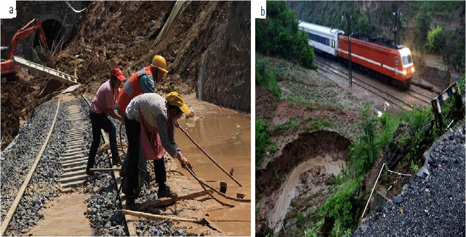
(a) Extreme precipitation-induced Landslide along Neikun Railway, 2013 (http://www.gov.cn/jrzg/2013-08/26/content_2474285.htm). (b) Subgrade collapse induced by extreme rainfall event along Longhai railway, 2010 (http://news.sohu.com/20100724/n273729529. shtml).
![Figure 2
A trend showing the different geohazard-related disasters on railway lines from 2000 to 2016 in China. (a Replot) [59].](/document/doi/10.1515/geo-2022-0558/asset/graphic/j_geo-2022-0558_fig_002.jpg)
A trend showing the different geohazard-related disasters on railway lines from 2000 to 2016 in China. (a Replot) [59].
Prior to the recent findings [59], it had been notably discovered that 90% of geohazards in China, including debris flows, landslides, and floods, are triggered or induced by rainfall events [60]. The majority of these rainfall-related geohazard events in China typically occur between May and September, corresponding to the period of historically highest rainfall, and they account for approximately 94% of all incidents [61]. Notably, due to the impact of climate change in China, there has been a significant increase in average annual precipitation from 2010 to 2016, leading to an escalation in extreme precipitation. The heightened susceptibility of railway networks is closely linked to these changing climate patterns. Southern China regions like Sichuan, Jiangxi, Chongqing, and Hunan, characterized by extreme rainfall events, have observed the most severe impacts of rainfall-related geohazards, as depicted in Figure 2 [61].
The vulnerability of transportation embankments worldwide could be reduced through a comprehensive comprehension of the interconnections among these constituent elements. Consequently, a greater emphasis is necessary on enhancing the understanding of transport infrastructure vulnerability to rainfall-induced geohazards. Conversely, owing to limited observed data, gauging the susceptibility degree of a soil structure poses a formidable challenge. Inadequate data concerning the vulnerability of these pertinent elements often confines assessment scope to peripheral risk analysis of infrastructure. Accurate data, including rainfall events, failure inventory, and soil characteristics, are imperative for the assessment of rainfall-induced transportation infrastructure failures.
Several studies have employed deterministic techniques to assess the susceptibility of infrastructure to geo-hazards. However, these models are often specific to particular sites and rely on geo-environmental factors such as weather, geology, and hydrology to validate their outcomes [16] Conversely, accurately determining the complexity of geo-hazards susceptibility assessments for transportation embankment systems using numerical and analytical methods is hindered by data characterization requirements and the need for robust computational capacity [17,58]. Additionally, researchers frequently utilize susceptibility maps to depict individual geo-hazards and employ soft computing techniques, including artificial neural networks [62], logistic regression [63], Bayesian network [64], statistical [65], random forest, support vector machine [66], and machine learning methods.
However, only limited efforts have been directed toward assessing multi-hazards induced by rainfall on railway infrastructure. This scarcity of data prevents the formation of conclusive judgments. Despite the promising technique known as RFA, challenges persist in result interpretation, overfitting of datasets, and accounting for geo-environmental variability. Consequently, conducting susceptibility assessments for railway infrastructure remains a formidable task. Therefore, new methodologies must be developed, alongside a priority placed on short and long-term data collection for understanding the susceptibility of transportation infrastructure globally. This effort should be coupled with the use of data-driven tools such as GEP (Gene Expression Programming) and machine learning methods to generate a generalized model for susceptibility mapping that can be applied in similar conditions.
4 Rainfall-induced embankment failures
Several kinds of literature have reported various causes of embankment failure [15,67,68,69], but the most prominent among them is rainfall-induced failure. It can trigger slope instability, regardless of whether water ponding occurs [70]. During rainfall events, the pore water pressure increases due to amplified transient seepage of water, which changes the soil permeability, consequently decreasing the effective stress of the soil particles [71]. When the shear strength reduces along the potential slide surface under sustained loading conditions, the soil mass may slide, subsequently resulting in embankment slope failure. Depending on the rainfall intensity, soil type, and moisture content before the rainfall events, the changes in the soil shear strength may be gradual or rapid [72]. Clearly, the relationship between water and soil is a complex interaction that many studies have attempted to comprehend. It is a necessary endeavor that can provide reliable information for predicting and preventing embankment hazards. Hence, understanding the variability in rainfall intensity/depth and its impact on the soil or fill material will greatly assist in controlling rainfall-induced embankment failure [73].
4.1 Need to determine rainfall threshold that results in embankment failures
While attempting to comprehend water-related geo-hazards, numerous studies have been conducted [74,75,76,77,78]. However, distinct rainfall patterns can have varying impacts on embankment hazards. Thus, a comprehensive understanding of rainfall distribution and patterns becomes imperative due to its geo-dependent nature. Consequently, numerous efforts have been made to establish a connection between rainfall patterns and geo-hazard occurrences, including embankment failures [15], landslides [79,80], and debris flows [81], among others. It has been noted that diverse geo-hazards exhibit distinct responses to a given rainfall event, attributed to varying rainfall thresholds that trigger different embankment failure mechanisms [82]. These thresholds hinge on factors such as location, soil type, characteristics, initial moisture level, infiltration rate, and the type of fill material, among others. Additionally, site topology, geology, and anthropogenic activities also exert an influence. Moreover, the duration of continuous rainfall exerts a more substantial impact on initiating embankment failure than the respective rainfall intensities [83]. During rainfall events, changes in pore-water pressure within embankment fill material occur at a slower pace than rainfall infiltration. These changes are influenced by moisture conditions, reduced soil suction, and diminished shear strength of the soil.
In order to comprehensively grasp the potential impact of a given rainfall event in causing embankment failure, certain conditions must be met: (a) A constant rainfall of a given duration and intensity that changes the safety factor of the slope, independent of the type of fill material used for the embankment structure. (b) The rate of rainfall distribution across the embankment area should be assumed to be uniform for both pore-water pressure and depend on soil permeability, considering uncertainties in soil hydraulic properties. (c) An increase in the duration and intensity of rainfall would lead to a reduction in shear strength, consequently influencing the stability of the embankment slope. (d) As the rainfall event progresses, the effects of wetted band suction gradually diminish, potentially leading to embankment failure due to the advancement of a deep wetted front.
Based on these outlined conditions drawn from existing literature, we propose the local and global development of a relationship between rainfall and embankment fill material. This endeavor would provide unique insights into how rainfall events alter the behavior of fill material and the extent to which they trigger failure and these required further laboratory and validation.
4.2 Observed failures under different rainfall conditions
Based on the information gathered from the existing literature (Table 3), the following classification of rainfall conditions is presented to provide a summary of how different rainfall patterns affect embankment stability. It is important to note that varying perspectives exist regarding the thresholds that define low or high rainfall intensities in hydrology [90]. However, for the purpose of this review, rainfall intensity equal to or less than 25 mm/h will be categorized as low intensity, while any intensity exceeding 25 mm/h will be classified as high intensity. This categorization is based on the assessment of the impact of different rainfall intensities on embankment fill material, as documented in various sources [41,91,92,93].
High rainfall intensity with short duration
Although it depends on the fill material, this condition often leads to slow infiltration and rapid overland flow. Consequently, embankment cracks, soil desiccation, and weakened side slopes can occur. In such cases, progressive failure may develop in the embankment.
High rainfall intensity with long duration
This situation is highly detrimental as both internal and external failure mechanisms become evident in the embankment structure. When coupled with the high rainfall intensity described in (a) above, but with an extended duration, rapid infiltration occurs due to rapid changes in soil permeability and other hydromechanical properties. This leads to swift and complete failure.
Low rainfall intensity with long duration
In this scenario, the infiltration rate remains high, and runoff is expected to be lower compared to conditions (a) and (b). However, the presence of perched water can vary, influenced by soil characteristics and seasonal fluctuations. Failures in this case typically initiate with internal expressions of failure.
Low rainfall intensity with low duration
Examples of impact of rainfall intensity on rainfall-induced embankment failures from literatures
| Rainfall durations (h) | Rainfall intensity (mm/h) | Date of occurrence | Soil type | Characteristics of soil shear stress | Comments | Location | References |
|---|---|---|---|---|---|---|---|
| 48 | 122.8–56.5 | Sept–Oct. 1994 | Sandy-clay | 30 kPa, 21°–29.4° | It results in erosion of road embankment slope, translational shadow slides, and voids | North-Eastern Spain | Alonso et al. [84] |
| 24 | 23.75 | Sep. 28, 1995 | Sandy-silt-clay | 0.2 kPa, 29.5° | Instability of railway embankment slope due to reduction of the soil suction as the infiltration increases | Malda, India | Raj and Sengupta [16] |
| 24 | 106 | July 5, 2017 | Sandy-clay/weathered rocks | 10 kPa, 10° | Soil erosion results in debris flow, landslides, and damage to several earth-fill structures | Japan | Park et al. [85] |
| 120 | 3.35 | 2009–2017 | Sand/gravels | 28.5 kPa, 35°–45° | The result to 82 landslides and embankment failures | Australia | Ravindran et al. [11] |
| 10 | 42.5 | Sep. 2012 | Sandy-silt-clay | 35–180 kPa | A landslide triggered by rainfall events as a result of slope failure and shear displacement due to increased pore water pressure | Nigeria | Igwe et al. [76] |
| 120 | 22.5 | Dec. 2006 | Sandy-clay | 10 kPa, 26° | Affects the stability of embankment slopes | Singapore | Rahimi et al. [86] |
| 48 | 35.81 | October 2–5, 2015 | Sandy | 0.02–9.81 kPa | Embankment failure due to rainfall events | South Carolina, USA | Tabrizi et al. [87] |
| 72–216 | 2.08–18.75 | July 16–19, 2011 & April 7–16, 2013 | Sandy-clay | 17.2 kPa, 18.3° | Impact of rainfall duration on the stability of road Embankment and its effects on it’s a safety factor | China | Tu and Huang [88] |
| 24 | 47 | Jul-16 | Silty | 10 kPa, 35° | Railway embankment stability under extreme rainfall events | Qianhai, China | Feng et al. [89] |
This situation illustrates how soil characteristics evolve based on the soil–water relationship. A gradual reduction in soil shear strength occurs, with minimal changes in soil properties. As a result, failure initiation is anticipated, but its manifestation occurs gradually over an extended period.
It is important to note that the extent of embankment failure is also influenced by the fill material, regardless of the type and magnitude of rainfall. For instance, embankment slopes with a low coefficient of permeability require prolonged rainfall to fail, irrespective of rainfall intensity, unlike slopes with a high coefficient of permeability [74].
In each scenario, rainfall has consistently been identified as a significant triggering factor in embankment failure. However, the degree of failure is contingent upon the specific conditions under which the rainfall event occurs [25], which our future research aims to explore.
4.3 Soil–water relationship
There are various analytical approaches used to assess the interaction between rainfall and embankment fill materials. These methods include the limit equilibrium technique [94], smoothed particle hydrodynamics [95], point estimation method [96], FEMs [97], and others. Many of these techniques, along with related approaches, incorporate soil–water relationship curves that integrate fundamental theories like Mohr–Coulomb, Drucker–Prager model, viscoelasticity, hardening soil, modified elastoplasticity, and viscoplastic modeling to elucidate the mechanisms behind rainfall-induced embankment failures. The underlying concept is that rainfall increases soil saturation, weakening the cohesive forces between soil particles by reducing shear strength, consequently leading to increased porosity [98]. This process results in elevated water content and reduced hydraulic conductivity and bulk density. The soil–water characteristic curve (Figure 3) illustrates the nonlinear interaction between soil and water by plotting volumetric water content against matric suction under saturated conditions. These curves delineate the correlation between water content and suction, portraying the concept of unsaturated behavior in soils with varying conductivity.
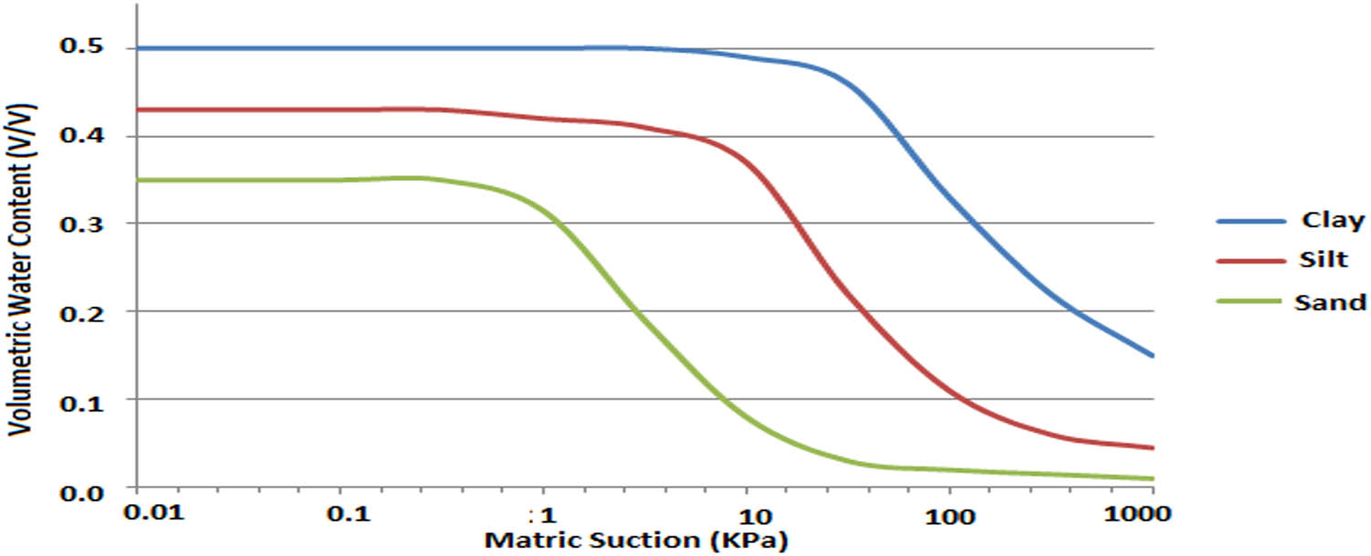
Example of the generalized soil–water characteristics curve for clay, silt, and sand.
This relationship appears complex, given the involvement of other factors. Under saturated conditions, soil–water interaction undergoes continuous changes compared to semi-saturated and unsaturated conditions [99]. Consequently, embankment fill materials often contain more sand than clay [39] and silt, leading to variations in soil structure and bearing capacity [100]. Observations indicate that during intense rainfall, as volumetric water content increases due to higher intensity and depth, metric suction rises with increased infiltration rate, while pore water pressure decreases [89]. This underscores the necessity of developing a soil-saturation curve to enhance soil–water interaction across different rainfall scenarios, as cycles of wetting and drying cause shifts in the soil–water retention curve [101]. At times, the soil loses its ability to generate the same level of suction at a given water content, signifying inconsistency in the soil structure’s response to rainfall infiltration.
Furthermore, embankment characteristics such as side slopes, crest width, bottom width, and height influence the matric suction and volumetric water content patterns under varying rainfall conditions [5]. These features lead to alterations in the water-soil relationship for each embankment during rainfall-induced situations, regardless of soil homogeneity. This complexity challenges the reliance on this relationship to derive conclusive insights into the embankment failure mechanism triggered by rainfall. Therefore, a comprehensive approach is needed, involving alternative parameters that capture the general soil behavior with water, such as rainfall intensity, duration, and the soil’s long-term strength [75].
4.4 Infiltration and moisture content contributions to embankment weakening
The understanding of rainwater infiltration and its effect on moisture content, particularly in unsaturated fill materials, is crucial for slope stability assessment. As rainwater infiltrates the soil, especially near the ground surface, soil suctions gradually decrease, approaching zero as the soil becomes saturated [102]. This significant reduction in soil suction can lead to decreased soil shear strength and subsequent weakening of the soil microstructure, potentially resulting in failure [103]. Additionally, the cyclic wetting and drying cycles, which cause shifts in the positions of soil particles, contribute to ongoing disruption of the soil microstructure, promoting internal erosion, soil sliding, debris flow, and other phenomena. Hence, the relationship between changes in moisture content and the effects of dynamic loads on the microstructure is complex yet critical in determining the extent of embankment weakening. Studies suggest that the presence of moisture content between soil particles reduces the effective friction angle, leading to a decrease in soil resilient modulus and strength, whether or not pore water pressure is generated [104].
On the other hand, the embankment profile is also affected by an increase in water content, which greatly influences the deformation of the subgrade. This effect was observed in a model test on slab track-subgrade material deformation characteristics with varying water content [60,105]. Additionally, liquefaction can occur in embankment materials due to rainfall infiltration, altering the cohesive properties of the soil and significantly reducing embankment stability [106]. This notion was further supported by [107], indicating that soil with reasonable stiffness and sufficient cohesion contributes to embankment stability. Thus, the mechanism of embankment failures is primarily attributed to fluctuating moisture content, which leads to a reduction in matric suction within the soil, subsequently weakening the soil microstructure and exacerbating the failure processes [108]. Understanding these components is crucial, as their related consequences encompass a wide range of issues, including diminished serviceability, disruptions in transportation services, compromised human safety, and economic losses. For instance, in China, an average of 0.52 billion US dollars is expended to mitigate infrastructural disasters arising from rainwater-induced railway failures [61,109].
There is limited literature available on real-time railway embankment weakening resulting from infiltration and variability in moisture content. Therefore, it is undeniable that a comprehensive understanding of the underexplored relationship between these factors, leading to embankment weakening, is essential for preparedness and mitigating their impact.
5 Embankment characteristics and their effects on infrastructure failures
Every embankment possesses unique characteristics that define the pattern, conditions, and extent of failure under rainfall-induced conditions. Embankments undergo evolution in four (4) stages: their foundation, fill materials, geometry, and the loading conditions they will experience throughout their service life. It has been observed that overstressing the foundation can lead to embankment failure [110]. This is particularly common for embankment foundations comprised of soft soils dominated by fine particles such as silt, clay, and peat, which exhibit low permeability and shear strength, along with high plasticity and compressibility. Several foundation methods have been proposed with the specific objective of preventing failures caused by water intrusion from the ground. Among the most promising techniques are soil bio-cementation [111], geosynthetic reinforced pile-supported embankment [112], and Nailed slab systems [113]. Despite the potential success of these methods, failures may still occur within treated foundations. To address this, the installation of monitoring instruments on site, such as inclinometers, settlement markers, and piezometers, is employed to oversee and prevent potential failures [114]. Instrumentation of the foundation is regarded as the most reliable approach for determining the responses of an embankment foundation during geo-hazard events [115].
The characteristics of embankment fill materials play a vital role in determining the extent of damage to infrastructure. For instance, the grain size distribution influences the shearing behavior of the soil–structure interface [116], which subsequently affects the compaction degree of the fill material and, consequently, the stability of the embankment. During onsite compaction, the edges of the embankment slope, particularly those lacking lateral restraints due to steepness and height, are typically not as firmly compacted. As illustrated in Figure 4, the failure depth decreases with increasing compaction coefficient, indicating that enhancing the compaction coefficient could reduce the infrastructure’s failure depth. Multiple considerations and analyses are conducted to ensure that fill materials meet the minimum safety factors before construction [117]. Compromising any of these procedures can lead to reduced limit states of the infrastructure, potentially resulting in failure depending on the embankment’s geometry.

Example of failure depth versus compaction coefficient.
The embankment’s geometry is contingent on factors such as the infrastructure’s purpose, location, type of foundations, and geo-environmental conditions. Among the most crucial aspects of embankment geometry is the side slope. Various attempts have been made to determine the optimal slope that resists failure and stabilizes the embankment structure [118]. Nobahar et al. [5] have attempted to identify the most resistant slope against failure under rainfall conditions. Their findings indicate that the slope ratio of H:0.5 V is more susceptible to failure compared to ratios of H:0.34 V and H:0.25 V. However, all the analyzed slope ratios may fail if the embankment experiences excessive rainfall alongside desiccation cracks and higher vertical permeability. To mitigate the risk of slope instability, it is essential to implement slope protective measures either partially or entirely [119].
The construction of embankments in transportation is limited to either road or railway systems. In each case, the load exerted on the embankment varies depending on the transportation system. According to Pham et al. [120], the load transfer on the embankment is often underestimated due to simple assumptions used in design procedures. Therefore, to ensure safety and maintain the service life of transportation embankments, accurate estimation techniques must be developed for each specific transportation system.
5.1 Hydro-mechanical properties
The dynamic state of soil moisture content, transitioning from an unsaturated to a fully saturated state due to hydrological changes induced by periodic rainfall and related events, is a matter of concern. These variations in saturation rates lead to significant alterations in the hydromechanical characteristics of the soil’s vadose zone [121,122,123]. Within the soil’s vadose zone, the suction stress parameter is used to elucidate the relationship between mechanical properties and hydrological variations. Suction stress governs the mechanical behavior of vadose soil zones, considering the saturation degree and suction head. Hydrological variations subject the soil to cyclic wetting and drying, resulting in seasonal fluctuations in soil suction stress, which in turn affects the mechanical properties of the soil.
Numerous studies across the globe on hydro-mechanical properties propose constitutive models for the vadose soil zone and employ modeling to simulate the hydromechanical behavior of compacted soil [39], incorporating density and initial conditions [124,125,126]. These studies indicate that anticipating the volumetric behavior patterns of vadose soil zones poses challenges in Geotechnical engineering, especially in terms of responses under soaking (swelling and collapse) and drying conditions (shrinkage and cracking) [127]. The characteristics of compacted soil and its mechanical behavior are not comprehensively covered in the highway earthwork and embankment handbooks [32].
Soil suction holds significant sway over the shear strength of soil in vadose soil zones, a context where highway embankments are often located. Conversely, moisture content and the saturation degree of vadose soil zones increase due to rainfall infiltration. Rainfall events alter water content distribution, subsequently impacting the mechanical behavior of embankment materials [128]. Simulation of real-time hydro-mechanical behavior of vadose zones and its stability analysis requires volumetric moisture content prediction and matric suction to be able to accurately predict the incremental soil deformation [129], as the increase in moisture content affects FOS as shown in Figure 5 [130]. An attempt was made [121] to predict the incremental soil deformation of hillslope using a modified Sheng, Fredlund, and Gens model by incorporating limited predicted hydrological data. However, there is scarce literature to substantiate the results of this study. Euler’s backward algorithm was coupled into the ABAQUS to generate a model that tried to mimic the hydromechanical behavior of soil and found that an increase in rainfall duration or rainfall intensity amplifies the pore water pressure, fluid velocity, horizontal displacement, and vertical strain of the slope [131], and on the other hand, unable to give details on the effects of short-duration rainfall with high intensity.

Relationship between volume water content and FOS.
The vadose zone undergoes progressive deformation as a result of changes in climatic conditions before reaching its final strength. Shear strength prediction methods, on the other hand, do not take progressive soil deformation into account. To simulate incremental soil deformation, constitutive models are widely used [132]. A variety of models have been developed to characterize the hydromechanical characteristics of the vadose zone. However, most models are unable to account for many properties of the vadose zone of soils, including slurry soil incremental deformation during the drying process, the transition stage from soil-soaked state to vadose zone, and the influence of changes in matric suction on the yield stress [121,133]. Thus, more effort is necessary to enhance the understanding of the mechanisms of rainfall-induced geo-hazard in hydromechanical behavior in complex regions such as China.
5.2 Wetting and drying cycles under rainfall events
Rainfall events impact the gradual degradation of soil mechanical performance due to wetting and drying processes. However, it is worth noting that drying exhibits a higher recovery in tensile strength compared to wetting conditions. The active processes during these cycles weaken the tensile strength generated within the soil structure. As strength diminishes due to wet-dry cycles, micro-cracks begin to form during the initial desiccation phase. These micro-cracks initiate a chain reaction, leading to subsequent microstructural changes [134]. The deteriorated material transforms into silt-sized particles, indicating a weathering process on the soil microstructure. Furthermore, the fill material’s deterioration can lead to settlement at various points along the embankment, such as the crest, toe, or foundation. This settlement alters the shear stress, influenced by the macro-porosity of the embankment, potentially triggering internal erosion [135]. Importantly, one of the consequences of the wet-dry cycle is that the effectiveness of fill material pre-treatment tends to diminish, jeopardizing the embankment’s stability [6].
5.3 Rainfall-induced cracks
The mechanisms behind embankment failure due to soil cracking are inherently complex. Understanding this phenomenon requires a solid grasp of vadose zone soil mechanics. Throughout climatic cycles, soils develop four types of cracks [136], wetting and drying cycles, tension cracks, desiccation cracks, and weathering cracks. The formation and extent of these cracks are contingent upon soil characteristics. Soil cracking poses a significant challenge, particularly in regions with soft or loess soils and other soil types prone to climate-induced variability. Numerous critical infrastructures are situated on such soils globally, including the 2016 Rio Olympic village in Brazil [137]. Major highways are in Texas, USA (along with Paris districts, Randell lake road, etc.) [138], UK highways in the Galston region [139], structures and roads around Willnis, Netherlands [140], highways and railways along Yangtze and Pearl Rivers [141], infrastructures in Regina region in Canada [29], rail and road networks connecting Tibetan Plateau and central China [142]. These soils exhibit high compressibility, making them susceptible to post-construction settlement and periodic cracking [141]. The consequences of cracking are twofold. First, cracks create pathways for preferential water movement in the future, altering both macro- and microstructures of the fill materials. This increased seepage and infiltration lead to rising pore water pressure and a reduction in soil shear strength [116,143]. While various methods have been employed to determine the width and depth of cracks, most of these studies have focused on highway cracks, with limited attention to railway cracks, particularly at greater depths [140]. Presently, the hydro-mechanical models used for slope stability are derived from continuum modeling techniques, which struggle to accurately represent the cracking process at the structural level and preferential water movement [140]. Some researchers have suggested soil modifications and treatments to reduce compressibility and minimize cracking [138,142,144]. However, certain critical aspects remain unaccounted for, including the stress fields triggered during shrinkage [145], changes in shear-induced pore-water pressures after cracking within the vadose zone of the embankment, and the intrusion of contaminants into the fill during seepage post-cracking-factors that influence embankment soil shear strength [7]. Furthermore, phenomena such as desiccation and tension cracking may result in the progressive degradation of embankment structures, an area that has received limited attention in railway networks. As a result, there is a pressing need to assess the initiation, evolution, patterns, and magnitudes of cracks, along with their mechanical behaviors at greater depths. This evaluation should also consider the impact of spatial variability on serviceability and ultimate limits states.
5.4 Sliding and finite slopes
In the engineering infrastructure design process, having an estimate of the FOS against sliding for the embankment slope and other pertinent information regarding the finite slope’s failure mode is of paramount importance. Typically, embankment slope failures are attributed to an increase in shear stress forces at the surface of the infrastructure, often triggered by rainfall [146]. The stability of the slope hinges on a comparison between resisting forces that prevent failure and forces that induce failure. Consequently, the FOS for an embankment serves to ensure the stability of the fill material against potential failures. Several factors are scrutinized to safeguard the FOS from being impacted by failure mechanisms, with the most critical ones being shear stress characteristics (cohesion and friction angle) and water level [147]. In the analysis of embankment slope stability, the surface of the slope is particularly susceptible to sliding, with the soil mass treated as a homogeneous unit (Figure 6). It is postulated that the soil at the surface of the slope can be segmented into slices that act vertically and parallel to each other. The stability of the slope surface relies on the stability of these individual slices, irrespective of the type of soil used as fill material [148]. However, it is important to note that while sliding failure can be mitigated using a FOS, if the finite slope surface undergoes alterations due to rainfall events, the sliding wedge might exceed the FOS threshold, resulting in failure. Rahimi et al. [86] observed that the FOS decreases regardless of the duration of rainfall, but its capacity to recover is slower for delayed rainfall patterns compared to normal and advanced patterns. This suggests that the potential for failure due to sliding is more pronounced during rainfall-induced embankment failures than with other geo-hazards. Therefore, there is a pressing need to assess the impact of rainfall on the sliding behavior of transportation embankments under various geometric conditions

Example of Sliding of transportation embankment.
5.5 Cutting and scours
Increasing runoff discharges resulting from changes in rainfall patterns have led to a growing number of embankment failures related to scouring and cutting around the world. For instance, China has experienced its share of these issues in its transportation systems, resulting in substantial costs for replacement and maintenance. Studies have shown that soils with high silt content are more susceptible to scouring compared to soils with lower silt content under similar rainfall conditions [149], often leading to cutting-related failures. Scouring refers to localized erosion that occurs in the vicinity of support structures for roads, railways, or other types of infrastructure. In the context of railway embankments, scouring can be categorized into three types:
Type I – crest scour: this usually happens under the ballast due to runoff flow buildup that may result in piping and seepage into the subgrade. This can over time cause surface cutting and soil subsidence which with changes in loading conditions may trigger failure.
Type II – slope scour: this is a result of overflow from the top of the crest when runoff carries fine particles down the slope creating pathways for future flow and gradually modifying the surface particle arrangement leading to soil softening and changes in surface microspores.
Type III – toe scour: this is the movement of toe materials due to runoff discharges around the toe leading to the development of void and holes that will eventually cause the redistribution of microstructures. This may result in progressive deterioration of the embankment toe, which may encourage fill cutting and sliding of part of the toe materials due to particle migrations.
Type I scouring can be challenging to detect early because ballast often covers the surface until obvious cutting and soil subsidence occur. Therefore, there is a need for physical and numerical modeling of these dynamic processes to gain a better understanding of their effects on the progressive deterioration of embankments [150]. It is also crucial to comprehend how active processes such as scour, cutting, sliding, etc., influence the reorientation of particles and their impact on permeability, shear modulus, and shear strength. Addressing these knowledge gaps is especially important in the context of the growing global rail industry, particularly in high-speed rail systems.
5.6 Erosion and debris flows
It is a well-known fact that erosion and debris flows are the aftermath of rainfall events, both of which have been identified in numerous studies for their destructive consequences on rail and road infrastructure embankments, leading to increased maintenance costs. However, a detailed analysis of embankment failure manifested through erosion and debris flows is not readily available [13]. The recent expansion of rail networks worldwide, including mountainous regions like China, has faced growing threats from external and internal erosion, resulting in soil loss and sediment movement. Nevertheless, an assessment of the erosive impact of soil loss in railway and road embankments due to rainfall remains unclear [151]. The intensity of rainfall plays a crucial role in determining the rate of soil erosion and the magnitude of debris flow. Soil particle loss from erosion can lead to changes in soil properties, such as structure, stiffness, density, settlement, and strength, ultimately weakening the soil microstructure and potentially causing slope failure propagated through debris flow. This erosion and sediment movement may disrupt the internal arrangement of the soil due to increased pore water pressure and the erodibility of embankment materials, although areas of mass movement, such as landslides, have received significant attention [152,153,154],
Understanding the rearrangement of microstructures due to water ingress, leading to erosion and dynamic loads on the tracks and its influence on hydromechanical behaviors, represents a potential knowledge gap for railway professionals. This is particularly important given the rapid development of high-speed railway networks. While water-induced properties and strength deterioration have been studied numerically and experimentally, with mechanisms of strength reduction identified [98], there are several potential research areas that need further exploration:
Investigating the real-time impact of progressive erosion conditions, and deformation of embankment structures nexus.
Advancing the weakening processes that trigger debris flow and subsequent embankment failure.
Studying erosion types and their effects under diverse dynamic loading conditions on engineered slopes that result in failure.
Determine the magnitude of erosion due to the impact of rainfall intensity that amplified debris flow and sudden embankment structural failure.
Examine the effect of live loads on embankments during progressive erosion processes, an aspect with limited contributions in the existing literature.
Conducting more physical and numerical modeling studies to assess the speed of traffic that may cause failure during gradual erosion conditions for both ballastless and ballasted tracks, considering different soil layers. Addressing these research areas can significantly contribute to our understanding of the complex interactions between erosion, embankment stability, and rail infrastructure, particularly in the context of high-speed rail systems.
5.7 Vegetation cover
The impact of vegetation on embankment stability has been explored extensively, as vegetation can influence slope stability in two primary ways: hydrological impacts and mechanical impacts. Hydrological impacts arise from processes like evapotranspiration, where vegetation removes soil water by pressure, leading to an increase in soil shear strength. Additionally, plant roots reinforce the soil by enhancing soil cohesion through mechanical means [155]. Vegetation plays a crucial role in sustainable soil management, helping to reduce soil erosion and minimize the impacts of land use [156]. Railway embankments, especially those consisting of loess soil, face various challenges due to the effects of rainstorms, such as soil loss, erosion, landslides, and sediment movement [157]. Various studies have investigated the use of vegetation cover to mitigate these effects. For instance, research has shown that the FOS of embankments may either decrease or increase depending on the density and weight of trees [158]. Recent work in China examined the influence of vegetation cover on landslide occurrence, particularly in response to extreme rainfall events and found that vegetation cover can reasonably control landslide distribution [159]. However, there are knowledge gaps in understanding the full extent of vegetation’s influence on embankment stability:
Root moisture abstraction and its relationship with soil water movement in the vadose zone, especially regarding soil layer discontinuities, need further exploration and quantification [159].
The influence of vegetation on the distribution of embankment pore water pressures over time and space, particularly during dormant vegetation periods, remains poorly studied [15].
It is essential to comprehend the effects of vegetation-induced suction and climate-induced cracking in embankments prone to progressive failures, given that vegetation can generate soil suctions of up to 1,500 kPa [160].

Soil-root reinforcement system: (a) tree vegetation and (b) herbaceous vegetation.
In conclusion, there is a need for more comprehensive research to understand the ecological and mechanical aspects of vegetation’s role in embankment stability. Such studies can help develop effective strategies to enhance the stability of transportation embankments, especially in regions prone to soil erosion and landslides [161].
5.8 Loading conditions
When constructing transportation embankments, ensuring stability under various traffic load conditions is of utmost importance to guarantee their safety [162]. Embankment instability can result in failure, which can occur due to even minor geo-hazard impacts or loads exceeding the initial design specifications. Typically, design considerations prioritize loading conditions, as they determine the embankment’s geometry and foundation type [51]. However, other factors that can influence the load-bearing capacity, geometry, and foundation stability of the embankment are often overlooked. Higher loading rates lead to increased stresses within the soil mass, causing the propagation of compression and the generation of pre-consolidation pressure [163]. Excess pore pressure in this context is influenced by the applied load’s magnitude, volumetric content, and grain size distribution. When water from rainfall infiltrates the embankment, it becomes vulnerable to failure due to shear stress and, in some cases, bending or buckling of the transportation asset [164]. To enhance embankment stability, it is crucial to include other potential hazards in the design considerations for transportation embankments. As the design safety factor of the infrastructure changes with rainfall infiltration, the limit state is expected to fluctuate accordingly.
6 Future and perspectives of rainfall-induced embankment failures
This section of the review aims to suggest potential conditions that can lead to embankment failures as a result of rainfall. Globally, critical infrastructure like railway embankments has experienced the devastating consequences of rainfall-induced failures, resulting in significant loss of lives and property damage. The uncertainties associated with interactions between rainfall and the vadose zone highlight the need for consistent monitoring to prevent and mitigate such catastrophic incidents. While measuring these uncertainties may be extremely challenging, preparedness remains paramount. Therefore, a geotechnical assessment is essential to understand how rainfall and related processes can trigger failures. Numerous factors contribute to these uncertainties [102] with changing rainfall patterns being a primary influencer alongside dynamic soil properties. Various efforts have been made to establish rainfall thresholds as a means of addressing these uncertainties. As highlighted by Islam [136] a comprehensive investigation into rainfall-induced embankment failures is necessary to develop effective early warning systems (EWSs). Such systems could substantially reduce failure risks and the associated maintenance costs by providing timely alerts to relevant authorities.
6.1 EWS for pore water pressure-induced failure
Initially, most transportation embankments meet the compaction criteria, but over time, many of them become susceptible to damage due to changing properties influenced by various factors. These embankment failures are catastrophic events that pose threats to lives and economic systems worldwide. Natural and engineered slopes alike are periodically affected by these failures due to numerous factors. In a changing climate, soil can undergo cycles of shrinkage and swelling [165,166], gradually softening and reducing its effective shear strength, ultimately decreasing the FOS [130]. Prolonged rainfall events can alter soil structures, making rail or road embankments more vulnerable to failure. An effective tool for mitigating the consequences of embankment failure is the EWS, which provides timely alerts for prompt action. However, different soil types behave uniquely in response to changes in saturation and pore water pressure during rainfall [167]. Recent efforts to develop EWSs for rainfall-induced railway embankment fill-related failures have been commendable, focusing on monitoring hydrological responses of the embankment slope under the influence of infiltration in saturated and unsaturated conditions, with an emphasis on pore water pressures [75,131,168]. These studies have revealed that most EWSs rely on empirical thresholds based on historical rainfall records and pore water pressure measurements, often overlooking crucial hydrogeological and geotechnical parameters, which are site-specific [136]. Recent research conducted in the state of Texas attempted to incorporate both hydrogeological and geotechnical parameters into slope failure modeling, achieving a prediction rate of about 70% [136]. However, this study faced challenges in accounting for vegetation and evaporation effects in slope failure analysis and lacked three-dimensional seepage and slope stability analysis, which is essential due to its influence in terms of curvatures. Additionally, many EWSs are based on 30 m × 30 m pixels in Digital Elevation Models, which may not accurately capture shallow slope failures. To address these issues, it is crucial to develop a Web-Geographical Information System-based EWS using real-time data from weather stations and machine learning tools. This approach can accurately create susceptibility maps for embankment failure, enhancing the effectiveness of EWSs.
Certain limitations still exist in the devices used for measuring pore water pressure [169]. For instance, tensiometers lack accuracy and have slow response times, making predictions challenging. Piezometers, while commonly used, can face issues like filter clogging and hydrodynamic time lag caused by changes in groundwater pressure. Other equipment, such as inclinometers and extensometers, are employed to measure horizontal displacement, evaluate vertical settlement of tracks, and monitor vertical deformations in embankments, but they also have their limitations. In recent times, remote sensing methods have made significant strides in monitoring and predicting environmental variables related to rainfall-induced slope failures. These methods include the use of displacement and 3D Laser Scanner Sensors [130,170], pipe strain gauges, tilt sensors, water level gauges, and more [171,172] to assess fill slope deformation characteristics during rainfall events. However, remote sensing approaches face several challenges: (a) direct automated techniques have a low acquisition frequency, (b) they can be affected by atmospheric disturbances, and (c) they lack the ability to penetrate underground [172]. These challenges cast doubt on the reliability of field and laboratory tests in providing useful information for engineers designing EWSs for railway embankments. Errors in these devices translate to errors in the results of the warning systems. Addressing embankment failures in areas prone to instability due to China’s complex geo-environment, characterized by 69.4% mountainous landmass [173], is of paramount importance. This necessitates the development of temporal and spatial approaches to tackle these issues.
6.2 Uncertainties in embankment constructions
Various factors influencing the stability of transportation embankments are associated with inevitable uncertainties. These uncertainties arise from changes in rainfall characteristics, soil strength, soil structure, and soil hydraulic properties [174]. They stem from the degree of heterogeneity in fill materials, which can affect the certainty and quality of embankment construction. The unpredictable nature of soil properties, foundation types, embankment geometry, and the complex interaction between water and soil can complicate embankment construction procedures [175]. Uncertainties in embankment construction begin with the design phase but become more pronounced during the actual construction process. During construction, it is imperative to accurately determine the compaction and strength of the filled soil; otherwise, the progressive effects of rainfall can lead to failure. Other critical factors include the slope’s inclination, the compatibility of fill soil permeability, the management of surface water runoff from the slope, and the flow of groundwater beneath the embankment’s foundation, all of which increase the risk of embankment failure [176]. Therefore, onsite engineers must carefully assess each of these factors during construction to instill confidence, ensure the embankment meets its design specifications, and achieves its intended service life. It is worth noting that uncertainties can be minimized if engineers proactively control these factors while considering external geo-hazards like rainfall, snow, and earthquakes that can further amplify uncertainties [45]. Practitioners must ensure that the impact of rainfall on fill soil is effectively managed during the construction process to prevent sudden changes in soil properties that could disrupt construction procedures and potentially lead to delays in infrastructure completion. Therefore, a comprehensive understanding of existing geo-hazards is essential to mitigate and manage uncertainties in embankment construction effectively.
6.3 Research trend in embankment stability analysis
Slope stability analysis is a fundamental process in civil engineering, vital for assessing the stability of slopes, embankments, dams, and other earth structures. In line with the key-terms from the strongest citation bursts in Table 2 and the keyword analysis in Table 1, various methods for analysing slope stability have shown evolving trends, which can be categorized into two phases: before and after the year 2002. Several publications before the year 2002 utilized methodologies centred on analytical and mathematical solutions. Afterward, there was a notable shift towards the use of numerical and simulation techniques, by integrating FEM, which emerged as the most widely accepted approach. It is important to recognize that the quality and reliability of the results in slope stability analysis are influenced by the data sources employed. These data sources are typically based on information derived from laboratory soil experiments, climatic data, and remote sensing data, all of which have inherent limitations. Drawing from the collective experience of the authors, an integration of synthetic aperture radar (SAR) as a replacement for the conventional GIS technique is proposed. This recommendation stems from the advantages offered by SAR data, which are invulnerable to weather conditions and cloud cover. Moreover, SAR data exhibit sensitivity to terrain configurations, making them a valuable addition to different research methodologies. The framework illustrating this proposed modification is depicted in Figure 8, although incorporating SAR data into the analysis aims to enhance the reliability and robustness of slope stability assessments, mitigating the limitations associated with conventional data sources.

Multi-scale framework for transportation embankment slope stability analysis.
7 Conclusion and future research
In this study, an in-depth bibliometric analysis was conducted on terms, keywords, and keyword plus relevant research publications in the field of transportation embankment failure research, covering the period from 2002 to 2022. The aim was to gain insights into trends in slope failure studies. The analysis revealed a shift in research trends, moving from analytical methods of stability analysis and the limit equilibrium method towards the adoption of FEMs, including numerical simulations. This review focuses primarily on the impact of rainfall-induced embankment failures and their influence on various aspects of embankment stability. These aspects include foundations, fill materials, embankment geometry, limit states, and loading conditions. Each of these components underwent a thorough evaluation based on existing literature, databases, and related research notes. One significant challenge highlighted in the study is the determination of rainfall thresholds that can lead to embankment instability problems. While this remains a complex task, the study categorized general rainfall events that trigger failure into four scenarios: high-intensity with long duration, low intensity with long duration, high intensity with short duration, and low intensity with short duration. Each of these rainfall scenarios corresponds to different failure mechanisms. Notably, the high-intensity with long-duration scenario is identified as the most progressive and rapid failure trigger, often resulting in the sudden collapse of the embankment. However, the study also outlines various failure mechanisms associated with each type of rainfall event. The infiltration of rainwater into the embankment slope surface is identified as a key factor leading to time-variability in embankment instability due to the heterogeneous behavior of the soil. Understanding the complex interrelationships between each failure mechanism remains a challenge, as no single model or experiment has comprehensively captured these intricate circumstances. Additionally, the study emphasizes the importance of considering alternative parameters, such as rainfall intensity, duration, and long-term soil strength, rather than relying solely on the soil-water relationship curve to understand embankment failure mechanisms triggered by rainfall. Real-time data collection on the weakening of railway embankments due to infiltration and moisture content variability is deemed imperative for accurately assessing infrastructure susceptibility and enhancing safety measures. The study acknowledges the existence of various models to characterize the hydromechanical properties of the vadose zone but points out that many of these models fall short in accounting for critical vadose soil properties. These include the transition from a soil-soaked state to the vadose zone and the influence of changes in matric suction on yield stress. The wet-dry cycle’s impact on fill material pre-treatment and the role of stress fields generated during shrinkage are also highlighted. The need for further research, both physical and numerical modeling studies, to assess different transportation embankment behaviors under various loading conditions and traffic speeds is emphasized. This is particularly relevant during gradual erosion conditions caused by deformation, cracks, or sliding. In summary, the study underscores the complexity of rainfall-induced embankment failures and the need for a multifaceted approach to understanding and mitigating these failures. It highlights the challenges, categorizes rainfall scenarios, and emphasizes the importance of alternative parameters and real-time data collection. Additionally, the study calls for enhanced modeling efforts and preparedness measures, leveraging advanced EWSs and in-situ observations to address the complex issue of embankment stability under the influence of rainfall-induced geo-hazards. The summary of the major lessons learned are:
Monitoring and Preparedness requirement: Rainfall-induced embankment failures pose significant risks to transportation infrastructure, including railways and roads. Monitoring and EWSs are crucial for preventing and mitigating such failures, as preparedness is key to reducing their impact.
Complexity of Failure Mechanisms: Rainfall can trigger various failure mechanisms in embankments, including slope liquefaction, cracks, scours, debris flows, and landslides. These mechanisms are often interconnected, making their understanding and prediction complex.
Role of Rainfall Characteristics: Different rainfall scenarios, including intensity and duration, can lead to distinct failure mechanisms. High-intensity, long-duration rainfall events are particularly progressive and can result in sudden embankment collapses.
Influence of Soil-Water Interactions: Rainfall infiltrates embankment soil, leading to a loss of matric suction and a decrease in shear strength. The behavior of soil with water, including its swelling and shrinkage cycles, is critical in understanding embankment stability.
Challenges in Measurement: There are limitations in measuring pore water pressure and other relevant parameters, such as accuracy, response time, and equipment reliability. Remote sensing methods show promise but face challenges like low acquisition frequency and atmospheric disturbances.
Construction Uncertainties: The construction phase of embankments is prone to uncertainties, especially in the face of changing soil properties, foundation types, and complex interactions between water and soil. Managing these uncertainties during construction is essential.
Holistic Approach Needs: To address rainfall-induced embankment failures comprehensively, a holistic approach that considers multiple factors, including hydrogeological and geotechnical parameters, is required. Models should account for factors such as vegetation, evaporation, and three-dimensional analysis.
Interdisciplinary Research: Rainfall-induced transportation embankment failures require interdisciplinary research involving geotechnical engineering, hydrology, remote sensing, and data science and most importantly in cooperating Interferometric SAR techniques to develop effective EWSs and monitoring approaches.
Global Implications: These lessons have global implications, with countries like China, which have extensive rail networks and high-speed rail systems, being particularly vulnerable to rainfall-induced geo-hazards.
Inter-particle bonding Research Needs: There is a need for further research to understand the effects of different rainfall scenarios on soil behavior, inter-particle bonding, and shear strength. Additionally, improving EWSs and monitoring techniques is essential to enhance infrastructure safety.
-
Funding information: The study was supported by the National Natural Science Foundation of China (Grant No. 42172322, U2268213, and 42007419) and the National Key Research and Development Program of China (No. 2018YFC1505403).
-
Author contributions: XU Linrong and Bamaiyi Usman ALIYU conceptualized the research idea. Bamaiyi Usman ALIYU source literatures and wrote the original manuscript. Al-Amin Danladi BELLO supervised and reviewed the original draft. XU Linrong and LI Yongwei reviewed the manuscript.
-
Conflict of interest: The authors declare that there is no conflict of interest.
-
Data availability statement: Data sharing is not applicable to this article as the authors did not create or analyze new data in this study.
References
[1] Moretti L, Loprencipe G. Climate change and transport infrastructures: State of the art. Sustainability. 2018;10(11):4098.10.3390/su10114098Search in Google Scholar
[2] Rattanachot W, Wang Y, Chong D, Suwansawas S. Adaptation strategies of transport infrastructures to global climate change. Transp Policy. 2015;41:159–66.10.1016/j.tranpol.2015.03.001Search in Google Scholar
[3] Koliokosta E. Publications of climate change impact on transport infrastructures-A Review. Transportation Research Board 96th Annual Meeting. Transportation Research Board; 2017. no. 17-00696.Search in Google Scholar
[4] Ye B, Jiang J, Liu J, Zheng Y, Zhou N. Research on quantitative assessment of climate change risk at an urban scale: Review of recent progress and outlook of future direction. Renew Sustain Energy Rev. 2021;135:110415.10.1016/j.rser.2020.110415Search in Google Scholar
[5] Nobahar M, Khan MS, Ivoke J. Combined effect of rainfall and shear strength on the stability of highway embankments made of Yazoo clay in Mississippi. Geotech Geol Eng. 2020;38:2787–802.10.1007/s10706-020-01187-8Search in Google Scholar
[6] Boluk B, Puppala AJ, Chakraborty S, Bhaskar P. Forensic analyses and rehabilitation of a failed highway embankment slope in texas. Transp Res Rec. 2021;2675(8):121–34.10.1177/0361198121996359Search in Google Scholar
[7] Ellithy GS, Stark TD. Case study: Unsaturated embankment failure on soft soils. J Geotech Geoenviron Eng. 2020;146(12):05020011.10.1061/(ASCE)GT.1943-5606.0002382Search in Google Scholar
[8] Wang Z, Li Q, Zhang N, Jin Y, Qin H, Ding J. Slope failure of biotreated sand embankments under rainfall conditions: experimental investigation and numerical simulation. Bull Eng Geol Environ. 2020;79(9):4683–99.10.1007/s10064-020-01850-7Search in Google Scholar
[9] McKenna G, Argyroudis SA, Winter MG, Mitoulis SA. Multiple hazard fragility analysis for granular highway embankments: Moisture ingress and scour. Transp Geotech. 2021;26:100431.10.1016/j.trgeo.2020.100431Search in Google Scholar
[10] Castelli F, Lentini V, Venti AD. Evaluation of unsaturated soil properties for a debris-flow simulation. Geosciences. 2021;11(2):64.10.3390/geosciences11020064Search in Google Scholar
[11] Ravindran S, Gratchev I, Jeng D-S. Analysis of rainfall-induced landslides in northern New South Wales, Australia. Aust Geomech. 2019;54(4):85–99.Search in Google Scholar
[12] Lee J-H, Kim S, Jang S-J, Kim K, Cho Y-C, Kim M. Preliminary analysis of a heavy rainfall–induced landslide on a slope with a photovoltaic power station in Hoengseong County, Gangwon Province, South Korea. Landslides. 2023;20:1763–7.10.1007/s10346-023-02077-9Search in Google Scholar
[13] Johnston I, Murphy W, Holden J. A review of floodwater impacts on the stability of transportation embankments. Earth-Sci Rev. 2021;215:103553.10.1016/j.earscirev.2021.103553Search in Google Scholar
[14] Abdelzaher MA, Shehata N. Hydration and synergistic features of nanosilica-blended high alkaline white cement pastes composites. Appl Nanosci. 2022;12(5):1731–46.10.1007/s13204-022-02399-5Search in Google Scholar
[15] Briggs K, Loveridge F, Glendinning S. Failures in transport infrastructure embankments. Eng Geol. 2017;219:107–17.10.1016/j.enggeo.2016.07.016Search in Google Scholar
[16] Raj M, Sengupta A. Rain-triggered slope failure of the railway embankment at Malda, India. Acta Geotech. 2014;9(5):789–98.10.1007/s11440-014-0345-9Search in Google Scholar
[17] Liu K, Wang M, Cao Y, Zhu W, Yang G. Susceptibility of existing and planned Chinese railway system subjected to rainfall-induced multi-hazards. Transp Res Part A: Policy Pract. 2018;117:214–26.10.1016/j.tra.2018.08.030Search in Google Scholar
[18] Wasowski J, Keefer DK, Lee C-T. Toward the next generation of research on earthquake-induced landslides: current issues and future challenges. Eng Geol. 2011;122(1–2):1–8.10.1016/j.enggeo.2011.06.001Search in Google Scholar
[19] Fu G, Yu J, Yu X, Ouyang R, Zhang Y, Wang P, et al. Temporal variation of extreme rainfall events in China, 1961–2009. J Hydrol. 2013;487:48–59.10.1016/j.jhydrol.2013.02.021Search in Google Scholar
[20] Zhou Y, Ren G. Change in extreme temperature event frequency over mainland China, 1961− 2008. Clim Res. 2011;50(2–3):125–39.10.3354/cr01053Search in Google Scholar
[21] Yan J, Liu J, Tseng F-M. An evaluation system based on the self-organizing system framework of smart cities: A case study of smart transportation systems in China. Technol Forecast Soc Change. 2020;153:119371.10.1016/j.techfore.2018.07.009Search in Google Scholar
[22] Jiang W, Tan Y. Overview on failures of urban underground infrastructures in complex geological conditions due to heavy rainfall in China during 1994–2018. Sustain Cities Soc. 2022;76:103509.10.1016/j.scs.2021.103509Search in Google Scholar
[23] Fiorucci F, Giordan D, Santangelo M, Dutto F, Rossi M, Guzzetti F. Criteria for the optimal selection of remote sensing optical images to map event landslides. Nat Hazards Earth Syst Sci. 2018;18(1):405–17.10.5194/nhess-18-405-2018Search in Google Scholar
[24] Baral A, Shahandashti M. Risk-averse rehabilitation decision framework for roadside slopes vulnerable to rainfall-induced geohazards. J Infrastruct Preserv Resil. 2022;3(1):12.10.1186/s43065-022-00057-2Search in Google Scholar
[25] Reale C, Gavin K, Martinovic K. Analysing the effect of rainfall on railway embankments using fragility curves. In: Transport Research Arena 2018: A digital era for transport; 2018.Search in Google Scholar
[26] Palin EJ, Stipanovic Oslakovic I, Gavin K, Quinn A. Implications of climate change for railway infrastructure. Wiley Interdiscip Rev: Clim Change. 2021;12(5):e728.10.1002/wcc.728Search in Google Scholar
[27] Polemio M, Lollino P. Failure of infrastructure embankments induced by flooding and seepage: a neglected source of hazard. Nat Hazards Earth Syst Sci. 2011;11(12):3383–96.10.5194/nhess-11-3383-2011Search in Google Scholar
[28] Maula B, Zhang L. Assessment of embankment factor safety using two commercially available programs in slope stability analysis. Procedia Eng. 2011;14:559–66.10.1016/j.proeng.2011.07.070Search in Google Scholar
[29] Qi S, Vanapalli SK. Stability analysis of an expansive clay slope: a case study of infiltration-induced shallow failure of an embankment in Regina, Canada. Int J Georesour Environ-IJGE (Former Int’l J Geohazards Environment). 7-19, 2015;1(1):1–1.10.15273/ijge.2015.01.003Search in Google Scholar
[30] Xu S, Zsáki A. Maximum safe freight train speed on railway embankments under rapid drawdown conditions based on coupled stress-seepage slope stability analysis. Transp Geotech. 2021;27:100486.10.1016/j.trgeo.2020.100486Search in Google Scholar
[31] Toll DG, Mendes J, Augarde CE, Karthikeyan M, Phoon KK, Gallipoli D, et al. Effects of climate change on slopes for transportation infrastructure. In: Advances in Transportation Geotechnics. CRC Press; 2008. p. 521–8.Search in Google Scholar
[32] Sakai T, Nakano M. Interpretation of the mechanical behavior of embankments having various compaction properties based on the soil skeleton structure. Soils Found. 2015;55(5):1069–85.10.1016/j.sandf.2015.09.009Search in Google Scholar
[33] Jiang S-H, Liu X, Huang J. Non-intrusive reliability analysis of unsaturated embankment slopes accounting for spatial variabilities of soil hydraulic and shear strength parameters. Eng Comput. 2020;1–14.10.1007/s00366-020-01108-6Search in Google Scholar
[34] Islam MS, Hosain M, Islam MS, Ahmed AD, Hoque F, Karim SU, et al. Disaster due to slope failure in the Pahartoli area of the Chittagong city, Bangladesh. Int J Sci Eng Res. 2015;6(3):246–51.Search in Google Scholar
[35] Abdelzaher MA. Performance and hydration characteristic of dark white evolution (DWE) cement composites blended with clay brick powder. Egypt J Chem. 2022;65(8):419–27.10.21608/ejchem.2022.113836.5169Search in Google Scholar
[36] Oorthuis R, Hürlimann M, Fraccica A, Lloret A, Moya J, Puig-Polo C, et al. Monitoring of a full-scale embankment experiment regarding soil–vegetation–atmosphere interactions. Water. 2018;10(6):688.10.3390/w10060688Search in Google Scholar
[37] Nobahar M, Salunke R, Alzeghoul OE, Khan M, Amini F. Mapping of slope failures on highway embankments using Electrical Resistivity Imaging (ERI), Unmanned Aerial Vehicle (UAV), and Finite Element Method (FEM) numerical modeling for forensic analysis. Transp Geotech. 2023;40:100949.10.1016/j.trgeo.2023.100949Search in Google Scholar
[38] Wang L, Luo D, Hamdaoui O, Vasseghian Y, Momotko M, Boczkaj G, et al. Bibliometric analysis and literature review of ultrasound-assisted degradation of organic pollutants. Sci Total Environ. 2023;876:162551.10.1016/j.scitotenv.2023.162551Search in Google Scholar PubMed
[39] Elkhouly HI, Abdelzaher M, El-Kattan IM. Experimental and modeling investigation of physicomechanical properties and firing resistivity of cement pastes incorporation of micro-date seed waste. Iran J Sci Technol, Trans Civ Eng. 2021;46(4):1–13.10.1007/s40996-021-00760-2Search in Google Scholar
[40] Dassanayake SM, Mousa AA, Ilankoon S, Fowmes GJ. Internal instability in soils: a critical review of the fundamentals and ramifications. Transp Res Rec. 2022;2676(4):1–26.10.1177/03611981211056908Search in Google Scholar
[41] Baral A, Shahandashti S. Identifying critical combination of roadside slopes susceptible to rainfall-induced failures. Nat Hazards. 2022;113(2):1177–98.10.1007/s11069-022-05343-6Search in Google Scholar
[42] Jin H, Wei Z, Wang S, Yu Q, Lü L, Wu Q, et al. Assessment of frozen-ground conditions for engineering geology along the Qinghai–Tibet highway and railway, China. Eng Geol. 2008;101(3–4):96–109.10.1016/j.enggeo.2008.04.001Search in Google Scholar
[43] Wang S, Jin L, Peng H, Chen J, Mu K. Damage analysis of the characteristics and development process of thermosyphon embankment along the Qinghai-Tibet Highway. Cold Reg Sci Technol. 2017;142:118–31.10.1016/j.coldregions.2017.07.003Search in Google Scholar
[44] Gallego Giner I, López Pita A, Vieira Chaves EW, Rivas Álvarez AM. Design of embankment–structure transitions for railway infrastructure. Proc Inst Civ Eng-Transp. 2012;165(1):27–37. Thomas Telford Ltd.10.1680/tran.8.00037Search in Google Scholar
[45] Gitirana Jr G. Weather-related geo-hazard assessment model for railway embankment stability. Doctoral dissertation; 2005.Search in Google Scholar
[46] Li S, Lai Y, Zhang M, Dong Y. Study on long-term stability of Qinghai–Tibet Railway embankment. Cold Reg Sci Technol. 2009;57(2–3):139–47.10.1016/j.coldregions.2009.02.003Search in Google Scholar
[47] Jin-ping L, Yu S. Analysis of the thermal stability of an embankment under different pavement types in high temperature permafrost regions. Cold Reg Sci Technol. 2008;54(2):120–3.10.1016/j.coldregions.2008.04.006Search in Google Scholar
[48] Zhang J, Li F, Zeng L, Peng J, Li J. Numerical simulation of the moisture migration of unsaturated clay embankments in southern China considering stress state. Bull Eng Geol Environ. 2021;80(1):11–24.10.1007/s10064-020-01916-6Search in Google Scholar
[49] Wu W, Zheng J, Cao W. Study of stability of compacted loess embankment considering effect of water content. Rock Soil Mech. 2015;36(S1):542–6.Search in Google Scholar
[50] Jianbin J. Analysis of Stability of Water Immersed Road Embankment by the River. Technol Highw Transp. 2008;1:12–4.Search in Google Scholar
[51] Bogusz W, Godlewski T. Geotechnical design of railway embankments–requirements and challenges. MATEC Web Conf. 2019;262:11002. EDP Sciences.10.1051/matecconf/201926211002Search in Google Scholar
[52] Aqib M, Usmani S, Khan T, Sadique MR, Alam MM. Experimental and numerical analysis of rainfall-induced slope failure of railway embankment of semi high-speed trains. J Eng Appl Sci. 2023;70(1):1–24.10.1186/s44147-023-00188-7Search in Google Scholar
[53] Kite D, Siino G, Audley M. Detecting embankment instability using measurable track geometry data. Infrastructures. 2020;5(3):29.10.3390/infrastructures5030029Search in Google Scholar
[54] Luo J, Niu F, Liu M, Lin Z, Yin G. Field experimental study on long-term cooling and deformation characteristics of crushed-rock revetment embankment at the Qinghai–Tibet Railway. Appl Therm Eng. 2018;139:256–63.10.1016/j.applthermaleng.2018.04.138Search in Google Scholar
[55] Stipanovic I, Bukhsh ZA, Reale C, Gavin K. A multiobjective decision-making model for risk-based maintenance scheduling of railway earthworks. Appl Sci. 2021;11(3):965.10.3390/app11030965Search in Google Scholar
[56] Namdar A. Design geometry of the embankment for minimize nonlinear displacement. Mater Des Process Commun. 2021;3(5):e209.10.1002/mdp2.209Search in Google Scholar
[57] Mamat RC, Ramli A, Kasa A, Razali SFM, Omar MBHC. Artificial neural networks in slope of road embankment stability applications: a review and future perspectives. Int J Adv Technol Eng Explor. 2021;8(75):304.10.19101/IJATEE.2020.762127Search in Google Scholar
[58] Liu K, Wang M, Cao Y, Zhu W, Wu J, Yan X. A comprehensive risk analysis of transportation networks affected by rainfall‐induced multihazards. Risk Anal. 2018;38(8):1618–33.10.1111/risa.12968Search in Google Scholar PubMed
[59] Zhao J, Liu K, Wang M. Exposure analysis of Chinese railways to multihazards based on datasets from 2000 to 2016. Geomat Nat Hazards Risk. 2020;11(1):272–87.10.1080/19475705.2020.1714753Search in Google Scholar
[60] Bai S, Wang J, Thiebes B, Cheng C, Yang Y. Analysis of the relationship of landslide occurrence with rainfall: a case study of Wudu County, China. Arab J Geosci. 2014;7(4):1277–85.10.1007/s12517-013-0939-9Search in Google Scholar
[61] Liu K, Wang M, Zhou T. Increasing costs to Chinese railway infrastructure by extreme precipitation in a warmer world. Transp Res Part D: Transp Environ. 2021;93:102797.10.1016/j.trd.2021.102797Search in Google Scholar
[62] Tian Y, Xu C, Hong H, Zhou Q, Wang D. Mapping earthquake-triggered landslide susceptibility by use of artificial neural network (ANN) models: an example of the 2013 Minxian (China) Mw 5.9 event. Geomat Nat Hazards Risk. 2019;10(1):1–25.10.1080/19475705.2018.1487471Search in Google Scholar
[63] Shao W, Yang Z, Ni J, Su Y, Nie W, Ma X. Comparison of single-and dual-permeability models in simulating the unsaturated hydro-mechanical behavior in a rainfall-triggered landslide. Landslides. 2018;15(12):2449–64.10.1007/s10346-018-1059-0Search in Google Scholar
[64] Song Y, Gong J, Gao S, Wang D, Cui T, Li Y, et al. Susceptibility assessment of earthquake-induced landslides using Bayesian network: A case study in Beichuan, China. Comput Geosci. 2012;42:189–99.10.1016/j.cageo.2011.09.011Search in Google Scholar
[65] Zhang Y, Qi G, Park J-H, Chatterjee N. Estimation of complex effect-size distributions using summary-level statistics from genome-wide association studies across 32 complex traits. Nat Genet. 2018;50(9):1318–26.10.1038/s41588-018-0193-xSearch in Google Scholar PubMed
[66] Li J, Wang W, Li Y, Han Z, Chen G. Spatiotemporal landslide susceptibility mapping incorporating the effects of heavy rainfall: A case study of the heavy rainfall in August 2021 in Kitakyushu, Fukuoka, Japan. Water. 2021;13(22):3312.10.3390/w13223312Search in Google Scholar
[67] Hossain Z, Islam Z, Sakai T. An investigation on failure of embankments in Bangladesh; 2008.Search in Google Scholar
[68] Tsubaki R, Kawahara Y, Ueda Y. Railway embankment failure due to ballast layer breach caused by inundation flows. Nat Hazards. 2017;87(2):717–38.10.1007/s11069-017-2789-3Search in Google Scholar
[69] Deshpande TD, Kumar S, Begum G, Basha S, Rao BH. Analysis of railway embankment supported with geosynthetic-encased stone columns in soft clays: a case study. Int J Geosynth Ground Eng. 2021;7(2):1–16.10.1007/s40891-021-00288-5Search in Google Scholar
[70] Kim Y, Rahardjo H, Nistor MM, Satyanaga A, Leong E-C, Sham AWL. Assessment of critical rainfall scenarios for slope stability analyses based on historical rainfall records in Singapore. Environ Earth Sci. 2022;81(2):1–13.10.1007/s12665-021-10160-4Search in Google Scholar
[71] Tozato K, Dolojan NL, Touge Y, Kure S, Moriguchi S, Kawagoe S, et al. Limit equilibrium method-based 3D slope stability analysis for wide area considering influence of rainfall. Eng Geol. 2022;308:106808.10.1016/j.enggeo.2022.106808Search in Google Scholar
[72] Rahardjo H, Nio AS, Leong EC, Song NY. Effects of groundwater table position and soil properties on stability of slope during rainfall. J Geotech Geoenviron Eng. 2010;136(11):1555–64.10.1061/(ASCE)GT.1943-5606.0000385Search in Google Scholar
[73] Kristo C, Rahardjo H, Satyanaga A. Effect of variations in rainfall intensity on slope stability in Singapore. Int Soil Water Conserv Res. 2017;5(4):258–64.10.1016/j.iswcr.2017.07.001Search in Google Scholar
[74] Rahardjo H, Ong T, Rezaur R, Leong EC. Factors controlling instability of homogeneous soil slopes under rainfall. J Geotech Geoenviron Eng. 2007;133(12):1532–43.10.1061/(ASCE)1090-0241(2007)133:12(1532)Search in Google Scholar
[75] Liu J, Yang C, Gan J, Liu Y, Wei L, Xie Q. Stability analysis of road embankment slope subjected to rainfall considering runoff-unsaturated seepage and unsaturated fluid–solid coupling. Int J Civ Eng. 2017;15(6):865–76.10.1007/s40999-017-0194-7Search in Google Scholar
[76] Igwe O, Mode W, Nnebedum O, Okonkwo I, Oha I. The analysis of rainfall-induced slope failures at Iva Valley area of Enugu State, Nigeria. Environ Earth Sci. 2014;71(5):2465–80.10.1007/s12665-013-2647-xSearch in Google Scholar
[77] Kumar P, Banerjee A, Chandra Congress SS, Puppala AJ. Effect of future extreme precipitation on expansive soil embankments. In: IFCEE. 2021. p. 255–66. https://ascelibrary.org/doi/abs/10.1061/9780784483428.027.10.1061/9780784483428.027Search in Google Scholar
[78] Zhang L, Zhang J, Zhang L, Tang WH. Stability analysis of rainfall-induced slope failure: a review. Proc Inst Civ Eng-Geotech Eng. 2011;164(5):299–316.10.1680/geng.2011.164.5.299Search in Google Scholar
[79] Dolojan NLJ, Moriguchi S, Hashimoto M, Terada K. Mapping method of rainfall-induced landslide hazards by infiltration and slope stability analysis. Landslides. 2021;18(6):2039–57.10.1007/s10346-020-01617-xSearch in Google Scholar
[80] Collins BD, Znidarcic D. Stability analyses of rainfall induced landslides. J Geotech Geoenviron Eng. 2004;130(4):362–72.10.1061/(ASCE)1090-0241(2004)130:4(362)Search in Google Scholar
[81] Zhang K, Wang S, Bao H, Zhao X. Characteristics and influencing factors of rainfall-induced landslide and debris flow hazards in Shaanxi Province, China. Nat Hazards Earth Syst Sci. 2019;19(1):93–105.10.5194/nhess-19-93-2019Search in Google Scholar
[82] Brunetti M, Peruccacci S, Rossi M, Luciani S, Valigi D, Guzzetti F. Rainfall thresholds for the possible occurrence of landslides in Italy. Nat Hazards Earth Syst Sci. 2010;10(3):447–58.10.5194/nhess-10-447-2010Search in Google Scholar
[83] Bogaard T, Greco R. Invited perspectives: Hydrological perspectives on precipitation intensity-duration thresholds for landslide initiation: proposing hydro-meteorological thresholds. Nat Hazards Earth Syst Sci. 2018;18(1):31–9.10.5194/nhess-18-31-2018Search in Google Scholar
[84] Alonso EE, Lloret A, Romero E. Rainfall induced deformations of road embankments. Ital Geotech J. 1999;33(1):71–6.Search in Google Scholar
[85] Park J, Vilayvong K, Son Y, Fujisawa K, Murakami A. Slope stability evaluation of an agricultural embankment by statistically derived rainfall patterns. Paddy Water Environ. 2019;17(3):303–13.10.1007/s10333-019-00725-2Search in Google Scholar
[86] Rahimi A, Rahardjo H, Leong E-C. Effect of antecedent rainfall patterns on rainfall-induced slope failure. J Geotech Geoenviron Eng. 2011;137(5):483–91.10.1061/(ASCE)GT.1943-5606.0000451Search in Google Scholar
[87] Tabrizi AA, LaRocque LA, Chaudhry MH, Viparelli E, Imran J. Embankment failures during the historic October 2015 flood in South Carolina: Case study. J Hydraul Eng. 2017;143(8):05017001.10.1061/(ASCE)HY.1943-7900.0001315Search in Google Scholar
[88] Tu G, Huang R. Infiltration in two types of embankments and the effects of rainfall time on the stability of slopes. Q J Eng Geol Hydrogeol. 2016;49(4):286–97.10.1144/qjegh2015-027Search in Google Scholar
[89] Feng J, Zhang L, Gao L, Feng S. Stability of railway embankment of China under extreme storms. Environ Geotech. 2018;6(5):269–83.10.1680/jenge.17.00043Search in Google Scholar
[90] Van Dijk A, Bruijnzeel L, Rosewell C. Rainfall intensity–kinetic energy relationships: a critical literature appraisal. J Hydrol. 2002;261(1–4):1–23.10.1016/S0022-1694(02)00020-3Search in Google Scholar
[91] Kumar S, Roy LB. Rainfall induced geotextile reinforced model slope embankment subjected to surcharge loading: A review study. Arch Comput Methods Eng. 2022;29:3203–21.10.1007/s11831-021-09688-2Search in Google Scholar
[92] Heyerdahl H, Høydal Ø, Nadim F, Kalsnes B, Børsting T. Rainfall-induced collapse of old railway embankments in Norway. In: International Conference on Soil Mechanics and Geotechnical Engineering; 2013.Search in Google Scholar
[93] Chen H, Lee C, Law K. Causative mechanisms of rainfall-induced fill slope failures. J Geotech Geoenviron Eng. 2004;130(6):593–602.10.1061/(ASCE)1090-0241(2004)130:6(593)Search in Google Scholar
[94] Liu S, Shao L, Li H. Slope stability analysis using the limit equilibrium method and two finite element methods. Comput Geotech. 2015;63:291–8.10.1016/j.compgeo.2014.10.008Search in Google Scholar
[95] Nonoyama H, Moriguchi S, Sawada K, Yashima A. Slope stability analysis using smoothed particle hydrodynamics (SPH) method. Soils Found. 2015;55(2):458–70.10.1016/j.sandf.2015.02.019Search in Google Scholar
[96] Chen Z, Du J, Yan J, Sun P, Li K, Li Y. Point estimation method: Validation, efficiency improvement, and application to embankment slope stability reliability analysis. Eng Geol. 2019;263:105232.10.1016/j.enggeo.2019.105232Search in Google Scholar
[97] Sujatono S. Integrated Slope Stability Analysis (SSA) with transient groundwater finite element method for embankment analysis. J Teknol. 2021;83(5):9–17.10.11113/jurnalteknologi.v83.16456Search in Google Scholar
[98] Lei X, He S, Chen X, Wong H, Wu L, Liu E. A generalized interpolation material point method for modelling coupled seepage-erosion-deformation process within unsaturated soils. Adv Water Resour. 2020;141:103578.10.1016/j.advwatres.2020.103578Search in Google Scholar
[99] Feng K, Huang D, Wang G. Two-layer material point method for modeling soil–water interaction in unsaturated soils and rainfall-induced slope failure. Acta Geotech. 2021;16(8):2529–51.10.1007/s11440-021-01222-9Search in Google Scholar
[100] Håkansson I, Lipiec J. A review of the usefulness of relative bulk density values in studies of soil structure and compaction. Soil Tillage Res. 2000;53(2):71–85.10.1016/S0167-1987(99)00095-1Search in Google Scholar
[101] Stirling RA, Toll DG, Glendinning S, Helm PR, Yildiz A, Hughes PN, et al. Weather-driven deterioration processes affecting the performance of embankment slopes. Géotechnique. 2021;71(11):957–69.10.1680/jgeot.19.SiP.038Search in Google Scholar
[102] Le TM, Sanchez M, Gallipoli D, Wheeler S. Probabilistic study of rainfall-triggered instabilities in randomly heterogeneous unsaturated finite slopes. Transp Porous Media. 2019;126(1):199–222.10.1007/s11242-018-1140-0Search in Google Scholar
[103] Yates K, Fenton C, Bell D. A review of the geotechnical characteristics of loess and loess-derived soils from Canterbury, South Island, New Zealand. Eng Geol. 2018;236:11–21.10.1016/j.enggeo.2017.08.001Search in Google Scholar
[104] Srivastava DK, Sahu V, Raghavendra H. Forensic study of slope failure case during heavy rainfall: Suggested preventative and remedial measures. Geotech Geol Eng. 2020;38(4):3697–707.10.1007/s10706-020-01247-zSearch in Google Scholar
[105] Chen R, Chen J, Zhao X, Bian X, Chen Y. Cumulative settlement of track subgrade in high-speed railway under varying water levels. Int J Rail Transp. 2014;2(4):205–20.10.1080/23248378.2014.959083Search in Google Scholar
[106] Hoque IL. Shear strength characteristics of sandy soil reinforced with vetiver root; 2019.Search in Google Scholar
[107] Bathurst RJ, Naftchali FM. Geosynthetic reinforcement stiffness for analytical and numerical modelling of reinforced soil structures. Geotext Geomembr. 2021;49(4):921–40.10.1016/j.geotexmem.2021.01.003Search in Google Scholar
[108] Kanazawa S-i. Stress analysis of river embankment considering external water level fluctuation. Geomate J. 2021;20(78):165–70.10.21660/2021.78.GX201Search in Google Scholar
[109] Zhu W, Liu K, Wang M, Nirandjan S, Koks E. How to use empirical data to improve transportation infrastructure risk assessment. Nat Hazards Earth Syst Sci Discuss. 2021;1–34.10.5194/nhess-2021-277Search in Google Scholar
[110] Adalier K, Elgamal A-W, Martin GR. Foundation liquefaction countermeasures for earth embankments. J Geotech Geoenviron Eng. 1998;124(6):500–17.10.1061/(ASCE)1090-0241(1998)124:6(500)Search in Google Scholar
[111] Safdar MU, Mavroulidou M, Gunn MJ, Garelick J, Payne I, Purchase D. Innovative methods of ground improvement for railway embankment peat fens foundation soil. Géotechnique. 2021;71(11):985–98.10.1680/jgeot.19.SiP.030Search in Google Scholar
[112] Gunnvard P, Mattsson H, Laue J. Evaluating the design criteria for light embankment piling: Timber piles in road and railway foundations. Appl Sci. 2022;12(1):166.10.3390/app12010166Search in Google Scholar
[113] Waruwu A, Hardiyatmo HC, Rifa’i A. The Performance of the nailed slab system-supported embankment on peat soil. Int Rev Civ Eng. 2019;10(5):243–8.10.15866/irece.v10i5.15757Search in Google Scholar
[114] Swenson JN, Dasenbrock DD. A Retrospective on the evolution of geotechnical sensing and instrumentation for monitoring at MnDOT. In: Geo-Congress 2020: University of Minnesota 68th Annual Geotechnical Engineering Conference. Reston, VA: American Society of Civil Engineers; 2020. p. 142–55.10.1061/9780784482841.011Search in Google Scholar
[115] Mu Y, Ma W, Li G, Mao Y, Liu Y. Long-term thermal and settlement characteristics of air convection embankments with and without adjacent surface water ponding in permafrost regions. Eng Geol. 2020;266:105464.10.1016/j.enggeo.2019.105464Search in Google Scholar
[116] Wang H-L, Zhou W-H, Yin Z-Y, Jie X-X. Effect of grain size distribution of sandy soil on shearing behaviors at soil–structure interface. J Mater Civ Eng. 2019;31(10):04019238.10.1061/(ASCE)MT.1943-5533.0002880Search in Google Scholar
[117] Zhang J, Ding L, Li F, Peng J. Recycled aggregates from construction and demolition wastes as alternative filling materials for highway subgrades in China. J Clean Prod. 2020;255:120223.10.1016/j.jclepro.2020.120223Search in Google Scholar
[118] Esmaeili M, Naderi B, Neyestanaki HK, Khodaverdian A. Investigating the effect of geogrid on stabilization of high railway embankments. Soils Found. 2018;58(2):319–32.10.1016/j.sandf.2018.02.005Search in Google Scholar
[119] Suhatril M, Osman N, Azura Sari P, Shariati M, Marto A. Significance of surface eco-protection techniques for cohesive soils slope in Selangor, Malaysia. Geotech Geol Eng. 2019;37(3):2007–14.10.1007/s10706-018-0740-3Search in Google Scholar
[120] Pham M-T, Vo D-N, Nguyen D-T, Do N-A. Numerical analysis of load transfer mechanisms within embankment reinforced by geosynthetic above cavity. Transp Infrastruct Geotechnol. 2023;10(2):311–28.10.1007/s40515-021-00220-4Search in Google Scholar
[121] Mahmoodabadi M, Bryson LS. Prediction of coupled hydromechanical behavior of unsaturated soils based on seasonal variations in hydrologic conditions. Can Geotech J. 2021;58(6):902–13.10.1139/cgj-2020-0388Search in Google Scholar
[122] Yang L, Liu E. Numerical analysis of the effects of crack characteristics on the stress and deformation of unsaturated soil slopes. Water. 2020;12(1):194.10.3390/w12010194Search in Google Scholar
[123] Pham K, Kim D, Lee IM, Choi H. Hydraulic‐mechanical properties of unsaturated granite‐weathered residual Soil in Korea. Vadose Zone J. 2019;18(1):1–13.10.2136/vzj2018.10.0188Search in Google Scholar
[124] Kodikara J. New framework for volumetric constitutive behaviour of compacted unsaturated soils. Can Geotech J. 2012;49(11):1227–43.10.1139/t2012-084Search in Google Scholar
[125] Alonso EE, Pinyol N, Gens A. Compacted soil behaviour: initial state, structure and constitutive modelling. Géotechnique. 2013;63(6):463–78.10.1680/geot.11.P.134Search in Google Scholar
[126] Zhou A, Sheng D. An advanced hydro-mechanical constitutive model for unsaturated soils with different initial densities. Comput Geotech. 2015;63:46–66.10.1016/j.compgeo.2014.07.017Search in Google Scholar
[127] Kodikara J, Costa S. Desiccation cracking in clayey soils: mechanisms and modelling. In: Multiphysical Testing of Soils and Shales. Berlin, Heidelberg: Springer Berlin Heidelberg; 2013. p. 21–32.10.1007/978-3-642-32492-5_2Search in Google Scholar
[128] Jafari NH, Cadigan JA, Stark TD, Woodward ML. Phreatic surface migration through an unsaturated levee embankment. J Geotech Geoenviron Eng. 2019;145(11):05019010.10.1061/(ASCE)GT.1943-5606.0002139Search in Google Scholar
[129] Baum RL, Godt JW, Savage WZ. Estimating the timing and location of shallow rainfall‐induced landslides using a model for transient, unsaturated infiltration. J Geophys Res: Earth Surf. 2010;115(F3).10.1029/2009JF001321Search in Google Scholar
[130] Zhang S, et al. Model test study on the hydrological mechanisms and early warning thresholds for loess fill slope failure induced by rainfall. Eng Geol. 2019;258:105135.10.1016/j.enggeo.2019.05.012Search in Google Scholar
[131] Cai G, Li M, Han B, Di K, Liu Q, Li J. Numerical analysis of unsaturated soil slopes under rainfall infiltration based on the modified glasgow coupled model. Adv Civ Eng. 2020;2020:8865179.10.1155/2020/8865179Search in Google Scholar
[132] Paswan AP, Shrivastava AK. Evaluation of a tilt-based monitoring system for rainfall-induced landslides: Development and physical modelling. Water. 2023;15(10):1862.10.3390/w15101862Search in Google Scholar
[133] Xie Y, Feng S-j, Xiong Y-l, Zhang L-l, Ye G-lJTG. Coupled hydraulic-mechanical-air simulation of unsaturated railway embankment under rainfall and dynamic train load. Transp Geotech. 2021;27:100463.10.1016/j.trgeo.2020.100463Search in Google Scholar
[134] Yu Z, Eminue OO, Stirling R, Davie C, Glendinning S. Desiccation cracking at field scale on a vegetated infrastructure embankment. Géotech Lett. 2021;11(1):88–95.10.1680/jgele.20.00108Search in Google Scholar
[135] Miščević P, Vlastelica G. Estimation of embankment settlement caused by deterioration of soft rock grains. Bull Eng Geol Environ. 2019;78(3):1843–53.10.1007/s10064-017-1203-4Search in Google Scholar
[136] Islam MA. Rainfall-induced slope failure–an early warning system. Arlington: The University of Texas at Arlington; 2021.Search in Google Scholar
[137] Indraratna B, Rujikiatkamjorn C, Vinod J. Ground improvement of extremely soft soils in Rio De Janeiro. https://www.researchgate.net/profile/Marcio-Almeida-4/publication/340850184_GROUND_IMPROVEMENT_OF_EXTREMELY_SOFT_SOILS_IN_RIO_DE_JANEIRO/links/5ea0c24e92851c87d1acf7b1/GROUND-IMPROVEMENT-OF-EXTREMELY-SOFT-SOILS-IN-RIO-DE-JANEIRO.pdf.Search in Google Scholar
[138] Boluk B, Chakraborty S, Puppala AJ, Jafari NH. Inverse analysis of a failed highway embankment slope in north texas. In: Advances in Transportation Geotechnics IV: Proceedings of the 4th International Conference on Transportation Geotechnics. 2021. Vol. 3 (pp. 583–594).10.1007/978-3-030-77238-3_44Search in Google Scholar
[139] Utili S, Castellanza R, Galli A, Sentenac P. Novel approach for health monitoring of earthen embankments. J Geotech Geoenviron Eng. 2015;141(3):04014111.10.1061/(ASCE)GT.1943-5606.0001215Search in Google Scholar
[140] Jamalinia E, Vardon PJ, Steele-Dunne SC. The impact of evaporation induced cracks and precipitation on temporal slope stability. Comput Geotech. 2020;122:103506.10.1016/j.compgeo.2020.103506Search in Google Scholar
[141] Zhou S, Wang B, Shan Y. Review of research on high-speed railway subgrade settlement in soft soil area. Railw Eng Sci. 2020;28(2):129–45.10.1007/s40534-020-00214-xSearch in Google Scholar
[142] Liu W, Yu W, Hu D, Lu Y, Chen L, Yi X, et al. Crack damage investigation of paved highway embankment in the Tibetan Plateau permafrost environments. Cold Reg Sci Technol. 2019;163:78–86.10.1016/j.coldregions.2019.05.003Search in Google Scholar
[143] Chen G, Meng X, Qiao L, Zhang Y, Wang S. Response of a loess landslide to rainfall: observations from a field artificial rainfall experiment in Bailong River Basin, China. Landslides. 2018;15(5):895–911.10.1007/s10346-017-0924-6Search in Google Scholar
[144] Liu B, Zhu C, Tang CS, Xie YH, Yin LY, Cheng Q, et al. Bio-remediation of desiccation cracking in clayey soils through microbially induced calcite precipitation (MICP). Eng Geol. 2020;264:105389.10.1016/j.enggeo.2019.105389Search in Google Scholar
[145] Stirling R, Davie C, Glendinning S. Numerical modelling of desiccation crack induced permeability. In: Proceedings of the 18th International Conference on Soil Mechanics and Geotechnical Engineering, Paris, Presses des Ponts, Paris, France. Vol. 813. 2013. p. 816.Search in Google Scholar
[146] Salmasi F, Pradhan B, Nourani B. Prediction of the sliding type and critical factor of safety in homogeneous finite slopes. Appl Water Sci. 2019;9(7):1–11.10.1007/s13201-019-1038-1Search in Google Scholar
[147] Salmasi F, Jafari F. A simple direct method for prediction of safety factor of homogeneous finite slopes. Geotech Geol Eng. 2019;37(5):3949–59.10.1007/s10706-019-00884-3Search in Google Scholar
[148] Hinds E, Lu N, Mirus B, Wayllace A. Effects of infiltration characteristics on spatial-temporal evolution of stability of an interstate highway embankment. J Geotech Geoenviron Eng. 2019;145(9):05019008.10.1061/(ASCE)GT.1943-5606.0002127Search in Google Scholar
[149] Qiu J, Shen Z, Wei G, Wang G, Xie H, Lv G. A systematic assessment of watershed-scale nonpoint source pollution during rainfall-runoff events in the Miyun Reservoir watershed. Environ Sci Pollut Res. 2018;25(7):6514–31.10.1007/s11356-017-0946-6Search in Google Scholar PubMed
[150] Abe K, Murotani K, Watanabe K. Development of Mpm-Mps coupling method and numerical analysis of scouring of embankment caused by overflow. J Jpn Soc Civ Eng, Ser A2 (Appl Mech (AM)). 2020;76(2):I_205–16.10.2208/jscejam.76.2_I_205Search in Google Scholar
[151] Cerdà A, Antonio G-M, Ángel G-PF, María B, Paulo P, Reyes RJ. Soil erosion on road and railways embankments in the Canyoles river Basin. Eastern Spain. 2012.Search in Google Scholar
[152] Schlögl M, Richter G, Avian M, Thaler T, Heiss G, Lenz G, et al. On the nexus between landslide susceptibility and transport infrastructure–an agent-based approach. Nat Hazards Earth Syst Sci. 2019;19(1):201–19.10.5194/nhess-19-201-2019Search in Google Scholar
[153] Chang CH, Chen H, Guo WD, Yeh SH, Chen WB, Liu CH, et al. Predicting river embankment failure caused by toe scour considering 1D and 2D hydraulic models: A case study of Da-An River, Taiwan. Water. 2020;12(4):1026.10.3390/w12041026Search in Google Scholar
[154] Haines A. Resilience of rail infrastructure. Interim report to the Secretary of State for Transport following the derailment at Carmont, near Stonehaven; 2020. p. 39–50.Search in Google Scholar
[155] Chok Y, Kaggwa G, Jaksa M, Griffiths D. Modelling the effects of vegetation on stability of slopes 9th Australia New Zealand Conference on Geomechanics, Auckland, New Zealand; 2004. Vol. 1, p. 391–397.Search in Google Scholar
[156] FAO. Voluntary Guidelines for Sustainable Soil Management Food and Agriculture Organization of the United Nations Rome, Italy; 2017.Search in Google Scholar
[157] Cerdà A. Soil water erosion on road embankments in eastern Spain. Sci Total Environ. 2007;378(1–2):151–5.10.1016/j.scitotenv.2007.01.041Search in Google Scholar PubMed
[158] Lan H, Wang D, He S, Fang Y, Chen W, Zhao P, et al. Experimental study on the effects of tree planting on slope stability. Landslides. 2020;17(4):1021–35.10.1007/s10346-020-01348-zSearch in Google Scholar
[159] Li M, Ma C, Du C, Yang W, Lyu L, Wang X. Landslide response to vegetation by example of July 25–26, 2013, extreme rainstorm, Tianshui, Gansu Province, China. Bull Eng Geol Environ. 2021;80(2):751–64.10.1007/s10064-020-02000-9Search in Google Scholar
[160] Briggs K, Smethurst J, Powrie W, O’Brien A. The influence of tree root water uptake on the long term hydrology of a clay fill railway embankment. Transp Geotech. 2016;9:31–48.10.1016/j.trgeo.2016.06.001Search in Google Scholar
[161] Löbmann MT, Geitner C, Wellstein C, Zerbe S. The influence of herbaceous vegetation on slope stability–A review. Earth-Sci Rev. 2020;209:103328.10.1016/j.earscirev.2020.103328Search in Google Scholar
[162] Filz G, Sloan J, McGuire MP, Collin J, Smith M. Column-supported embankments: settlement and load transfer. In: Geotechnical Engineering state of the Art and Practice: Keynote Lectures from GeoCongress. Vol. 2012; 2012. p. 54–77.10.1061/9780784412138.0003Search in Google Scholar
[163] Lim JX, Chong SY, Tanaka Y, Ong YH, Lee ML. Influence of consolidation pressure on stress-deformation responses of bio-mediated residual soil in Malaysia. Int J Geotech Eng. 2021;15(8):994–1007.10.1080/19386362.2020.1836113Search in Google Scholar
[164] Roshan M, Rashid A, Wahab N, Hezmi M, Jusoh S, Azmi M. Stability of railway embankment in saturated and unsaturated conditions. IOP Conf Ser: Mater Sci Eng. 2021;1153(1):012007. IOP Publishing.10.1088/1757-899X/1153/1/012007Search in Google Scholar
[165] Sangirardi M, Amorosi A, de Felice G. A coupled structural and geotechnical assessment of the effects of a landslide on an ancient monastery in Central Italy. Eng Struct. 2020;225:111249.10.1016/j.engstruct.2020.111249Search in Google Scholar
[166] Abbey SJ, Eyo EU, Oti J, Amakye SY, Ngambi S. Mechanical properties and microstructure of fibre-reinforced clay blended with by-product cementitious materials. Geosciences. 2020;10(6):241.10.3390/geosciences10060241Search in Google Scholar
[167] Hossain J, Hossain M, Hoyos L. Effect of rainfall on stability of unsaturated earth slopes constructed on expansive clay. In: Geo-Congress 2013: Stability and Performance of Slopes and Embankments III; 2013. p. 417–25.10.1061/9780784412787.042Search in Google Scholar
[168] Tohari A, Nishigaki M, Komatsu M. Laboratory rainfall-induced slope failure with moisture content measurement. J Geotech Geoenviron Eng. 2007;133(5):575–87.10.1061/(ASCE)1090-0241(2007)133:5(575)Search in Google Scholar
[169] Picarelli L, Di Maio C, Tommasi P, Urciuoli G, Comegna L. Pore water pressure measuring and modeling in stiff clays and clayey flysch deposits: A challenging problem. Eng Geol. 2022;296:106442.10.1016/j.enggeo.2021.106442Search in Google Scholar
[170] Chen Y, Irfan M, Uchimura T, Zhang K. Feasibility of using elastic wave velocity monitoring for early warning of rainfall-induced slope failure. Sensors. 2018;18(4):997.10.3390/s18040997Search in Google Scholar PubMed PubMed Central
[171] Sheikh MR, Nakata Y, Shitano M, Kaneko M. Rainfall-induced unstable slope monitoring and early warning through tilt sensors. Soils Found. 2021;61(4):1033–53.10.1016/j.sandf.2021.05.010Search in Google Scholar
[172] Chae B-G, Park H-J, Catani F, Simoni A, Berti M. Landslide prediction, monitoring and early warning: a concise review of state-of-the-art. Geosci J. 2017;21(6):1033–70.10.1007/s12303-017-0034-4Search in Google Scholar
[173] Liu Y, Deng W, Song X-Q. Relief degree of land surface and population distribution of mountainous areas in China. J Mt Sci. 2015;12(2):518–32.10.1007/s11629-013-2937-5Search in Google Scholar
[174] Zhang L, Zhang L, Tang W. Rainfall-induced slope failure considering variability of soil properties. Geotechnique. 2005;55(2):183–8.10.1680/geot.2005.55.2.183Search in Google Scholar
[175] Clough RW, Woodward III RJ. Analysis of embankment stresses and deformations. J Soil Mech Found Div. 1967;93(4):529–49.10.1061/JSFEAQ.0001005Search in Google Scholar
[176] Jia M, Zhu W, Xu C. Performance of a 33m high geogrid reinforced soil embankment without concrete panel. Geotext Geomembr. 2021;49(1):122–9.10.1016/j.geotexmem.2020.07.008Search in Google Scholar
© 2023 the author(s), published by De Gruyter
This work is licensed under the Creative Commons Attribution 4.0 International License.
Articles in the same Issue
- Regular Articles
- Diagenesis and evolution of deep tight reservoirs: A case study of the fourth member of Shahejie Formation (cg: 50.4-42 Ma) in Bozhong Sag
- Petrography and mineralogy of the Oligocene flysch in Ionian Zone, Albania: Implications for the evolution of sediment provenance and paleoenvironment
- Biostratigraphy of the Late Campanian–Maastrichtian of the Duwi Basin, Red Sea, Egypt
- Structural deformation and its implication for hydrocarbon accumulation in the Wuxia fault belt, northwestern Junggar basin, China
- Carbonate texture identification using multi-layer perceptron neural network
- Metallogenic model of the Hongqiling Cu–Ni sulfide intrusions, Central Asian Orogenic Belt: Insight from long-period magnetotellurics
- Assessments of recent Global Geopotential Models based on GPS/levelling and gravity data along coastal zones of Egypt
- Accuracy assessment and improvement of SRTM, ASTER, FABDEM, and MERIT DEMs by polynomial and optimization algorithm: A case study (Khuzestan Province, Iran)
- Uncertainty assessment of 3D geological models based on spatial diffusion and merging model
- Evaluation of dynamic behavior of varved clays from the Warsaw ice-dammed lake, Poland
- Impact of AMSU-A and MHS radiances assimilation on Typhoon Megi (2016) forecasting
- Contribution to the building of a weather information service for solar panel cleaning operations at Diass plant (Senegal, Western Sahel)
- Measuring spatiotemporal accessibility to healthcare with multimodal transport modes in the dynamic traffic environment
- Mathematical model for conversion of groundwater flow from confined to unconfined aquifers with power law processes
- NSP variation on SWAT with high-resolution data: A case study
- Reconstruction of paleoglacial equilibrium-line altitudes during the Last Glacial Maximum in the Diancang Massif, Northwest Yunnan Province, China
- A prediction model for Xiangyang Neolithic sites based on a random forest algorithm
- Determining the long-term impact area of coastal thermal discharge based on a harmonic model of sea surface temperature
- Origin of block accumulations based on the near-surface geophysics
- Investigating the limestone quarries as geoheritage sites: Case of Mardin ancient quarry
- Population genetics and pedigree geography of Trionychia japonica in the four mountains of Henan Province and the Taihang Mountains
- Performance audit evaluation of marine development projects based on SPA and BP neural network model
- Study on the Early Cretaceous fluvial-desert sedimentary paleogeography in the Northwest of Ordos Basin
- Detecting window line using an improved stacked hourglass network based on new real-world building façade dataset
- Automated identification and mapping of geological folds in cross sections
- Silicate and carbonate mixed shelf formation and its controlling factors, a case study from the Cambrian Canglangpu formation in Sichuan basin, China
- Ground penetrating radar and magnetic gradient distribution approach for subsurface investigation of solution pipes in post-glacial settings
- Research on pore structures of fine-grained carbonate reservoirs and their influence on waterflood development
- Risk assessment of rain-induced debris flow in the lower reaches of Yajiang River based on GIS and CF coupling models
- Multifractal analysis of temporal and spatial characteristics of earthquakes in Eurasian seismic belt
- Surface deformation and damage of 2022 (M 6.8) Luding earthquake in China and its tectonic implications
- Differential analysis of landscape patterns of land cover products in tropical marine climate zones – A case study in Malaysia
- DEM-based analysis of tectonic geomorphologic characteristics and tectonic activity intensity of the Dabanghe River Basin in South China Karst
- Distribution, pollution levels, and health risk assessment of heavy metals in groundwater in the main pepper production area of China
- Study on soil quality effect of reconstructing by Pisha sandstone and sand soil
- Understanding the characteristics of loess strata and quaternary climate changes in Luochuan, Shaanxi Province, China, through core analysis
- Dynamic variation of groundwater level and its influencing factors in typical oasis irrigated areas in Northwest China
- Creating digital maps for geotechnical characteristics of soil based on GIS technology and remote sensing
- Changes in the course of constant loading consolidation in soil with modeled granulometric composition contaminated with petroleum substances
- Correlation between the deformation of mineral crystal structures and fault activity: A case study of the Yingxiu-Beichuan fault and the Milin fault
- Cognitive characteristics of the Qiang religious culture and its influencing factors in Southwest China
- Spatiotemporal variation characteristics analysis of infrastructure iron stock in China based on nighttime light data
- Interpretation of aeromagnetic and remote sensing data of Auchi and Idah sheets of the Benin-arm Anambra basin: Implication of mineral resources
- Building element recognition with MTL-AINet considering view perspectives
- Characteristics of the present crustal deformation in the Tibetan Plateau and its relationship with strong earthquakes
- Influence of fractures in tight sandstone oil reservoir on hydrocarbon accumulation: A case study of Yanchang Formation in southeastern Ordos Basin
- Nutrient assessment and land reclamation in the Loess hills and Gulch region in the context of gully control
- Handling imbalanced data in supervised machine learning for lithological mapping using remote sensing and airborne geophysical data
- Spatial variation of soil nutrients and evaluation of cultivated land quality based on field scale
- Lignin analysis of sediments from around 2,000 to 1,000 years ago (Jiulong River estuary, southeast China)
- Assessing OpenStreetMap roads fitness-for-use for disaster risk assessment in developing countries: The case of Burundi
- Transforming text into knowledge graph: Extracting and structuring information from spatial development plans
- A symmetrical exponential model of soil temperature in temperate steppe regions of China
- A landslide susceptibility assessment method based on auto-encoder improved deep belief network
- Numerical simulation analysis of ecological monitoring of small reservoir dam based on maximum entropy algorithm
- Morphometry of the cold-climate Bory Stobrawskie Dune Field (SW Poland): Evidence for multi-phase Lateglacial aeolian activity within the European Sand Belt
- Adopting a new approach for finding missing people using GIS techniques: A case study in Saudi Arabia’s desert area
- Geological earthquake simulations generated by kinematic heterogeneous energy-based method: Self-arrested ruptures and asperity criterion
- Semi-automated classification of layered rock slopes using digital elevation model and geological map
- Geochemical characteristics of arc fractionated I-type granitoids of eastern Tak Batholith, Thailand
- Lithology classification of igneous rocks using C-band and L-band dual-polarization SAR data
- Analysis of artificial intelligence approaches to predict the wall deflection induced by deep excavation
- Evaluation of the current in situ stress in the middle Permian Maokou Formation in the Longnüsi area of the central Sichuan Basin, China
- Utilizing microresistivity image logs to recognize conglomeratic channel architectural elements of Baikouquan Formation in slope of Mahu Sag
- Resistivity cutoff of low-resistivity and low-contrast pays in sandstone reservoirs from conventional well logs: A case of Paleogene Enping Formation in A-Oilfield, Pearl River Mouth Basin, South China Sea
- Examining the evacuation routes of the sister village program by using the ant colony optimization algorithm
- Spatial objects classification using machine learning and spatial walk algorithm
- Study on the stabilization mechanism of aeolian sandy soil formation by adding a natural soft rock
- Bump feature detection of the road surface based on the Bi-LSTM
- The origin and evolution of the ore-forming fluids at the Manondo-Choma gold prospect, Kirk range, southern Malawi
- A retrieval model of surface geochemistry composition based on remotely sensed data
- Exploring the spatial dynamics of cultural facilities based on multi-source data: A case study of Nanjing’s art institutions
- Study of pore-throat structure characteristics and fluid mobility of Chang 7 tight sandstone reservoir in Jiyuan area, Ordos Basin
- Study of fracturing fluid re-discharge based on percolation experiments and sampling tests – An example of Fuling shale gas Jiangdong block, China
- Impacts of marine cloud brightening scheme on climatic extremes in the Tibetan Plateau
- Ecological protection on the West Coast of Taiwan Strait under economic zone construction: A case study of land use in Yueqing
- The time-dependent deformation and damage constitutive model of rock based on dynamic disturbance tests
- Evaluation of spatial form of rural ecological landscape and vulnerability of water ecological environment based on analytic hierarchy process
- Fingerprint of magma mixture in the leucogranites: Spectroscopic and petrochemical approach, Kalebalta-Central Anatolia, Türkiye
- Principles of self-calibration and visual effects for digital camera distortion
- UAV-based doline mapping in Brazilian karst: A cave heritage protection reconnaissance
- Evaluation and low carbon ecological urban–rural planning and construction based on energy planning mechanism
- Modified non-local means: A novel denoising approach to process gravity field data
- A novel travel route planning method based on an ant colony optimization algorithm
- Effect of time-variant NDVI on landside susceptibility: A case study in Quang Ngai province, Vietnam
- Regional tectonic uplift indicated by geomorphological parameters in the Bahe River Basin, central China
- Computer information technology-based green excavation of tunnels in complex strata and technical decision of deformation control
- Spatial evolution of coastal environmental enterprises: An exploration of driving factors in Jiangsu Province
- A comparative assessment and geospatial simulation of three hydrological models in urban basins
- Aquaculture industry under the blue transformation in Jiangsu, China: Structure evolution and spatial agglomeration
- Quantitative and qualitative interpretation of community partitions by map overlaying and calculating the distribution of related geographical features
- Numerical investigation of gravity-grouted soil-nail pullout capacity in sand
- Analysis of heavy pollution weather in Shenyang City and numerical simulation of main pollutants
- Road cut slope stability analysis for static and dynamic (pseudo-static analysis) loading conditions
- Forest biomass assessment combining field inventorying and remote sensing data
- Late Jurassic Haobugao granites from the southern Great Xing’an Range, NE China: Implications for postcollision extension of the Mongol–Okhotsk Ocean
- Petrogenesis of the Sukadana Basalt based on petrology and whole rock geochemistry, Lampung, Indonesia: Geodynamic significances
- Numerical study on the group wall effect of nodular diaphragm wall foundation in high-rise buildings
- Water resources utilization and tourism environment assessment based on water footprint
- Geochemical evaluation of the carbonaceous shale associated with the Permian Mikambeni Formation of the Tuli Basin for potential gas generation, South Africa
- Detection and characterization of lineaments using gravity data in the south-west Cameroon zone: Hydrogeological implications
- Study on spatial pattern of tourism landscape resources in county cities of Yangtze River Economic Belt
- The effect of weathering on drillability of dolomites
- Noise masking of near-surface scattering (heterogeneities) on subsurface seismic reflectivity
- Query optimization-oriented lateral expansion method of distributed geological borehole database
- Petrogenesis of the Morobe Granodiorite and their shoshonitic mafic microgranular enclaves in Maramuni arc, Papua New Guinea
- Environmental health risk assessment of urban water sources based on fuzzy set theory
- Spatial distribution of urban basic education resources in Shanghai: Accessibility and supply-demand matching evaluation
- Spatiotemporal changes in land use and residential satisfaction in the Huai River-Gaoyou Lake Rim area
- Walkaway vertical seismic profiling first-arrival traveltime tomography with velocity structure constraints
- Study on the evaluation system and risk factor traceability of receiving water body
- Predicting copper-polymetallic deposits in Kalatag using the weight of evidence model and novel data sources
- Temporal dynamics of green urban areas in Romania. A comparison between spatial and statistical data
- Passenger flow forecast of tourist attraction based on MACBL in LBS big data environment
- Varying particle size selectivity of soil erosion along a cultivated catena
- Relationship between annual soil erosion and surface runoff in Wadi Hanifa sub-basins
- Influence of nappe structure on the Carboniferous volcanic reservoir in the middle of the Hongche Fault Zone, Junggar Basin, China
- Dynamic analysis of MSE wall subjected to surface vibration loading
- Pre-collisional architecture of the European distal margin: Inferences from the high-pressure continental units of central Corsica (France)
- The interrelation of natural diversity with tourism in Kosovo
- Assessment of geosites as a basis for geotourism development: A case study of the Toplica District, Serbia
- IG-YOLOv5-based underwater biological recognition and detection for marine protection
- Monitoring drought dynamics using remote sensing-based combined drought index in Ergene Basin, Türkiye
- Review Articles
- The actual state of the geodetic and cartographic resources and legislation in Poland
- Evaluation studies of the new mining projects
- Comparison and significance of grain size parameters of the Menyuan loess calculated using different methods
- Scientometric analysis of flood forecasting for Asia region and discussion on machine learning methods
- Rainfall-induced transportation embankment failure: A review
- Rapid Communication
- Branch fault discovered in Tangshan fault zone on the Kaiping-Guye boundary, North China
- Technical Note
- Introducing an intelligent multi-level retrieval method for mineral resource potential evaluation result data
- Erratum
- Erratum to “Forest cover assessment using remote-sensing techniques in Crete Island, Greece”
- Addendum
- The relationship between heat flow and seismicity in global tectonically active zones
- Commentary
- Improved entropy weight methods and their comparisons in evaluating the high-quality development of Qinghai, China
- Special Issue: Geoethics 2022 - Part II
- Loess and geotourism potential of the Braničevo District (NE Serbia): From overexploitation to paleoclimate interpretation