High-speed inter-satellite link construction technology for navigation constellation oriented to engineering practice
-
Canyou Liu
 ,
Feng Zhang
,
Feng Zhang

Abstract
This article presents a study on the design of high-speed inter-satellite links for the global navigation satellite system, which consists of 24 middle earth orbit, 3 inclined geosynchronous orbit, 3 geostationary orbit satellites, and 4 typical ground stations based on the laser link of slowly varying continuous system and high-speed Ka link. Pre-allocation of node connections in inter-satellite link construction is conducted by employing the optimized Dijkstra algorithm using finite-state automata. In addition, topological design and routing planning principles are utilized for high-speed inter-satellite links. Based on full constellation orbit data of a regression period and locations of the ground station nodes, an hourly link construction program is obtained using the scheme described above. The calculation result of the position dilution of precision values of all satellites, the average inter-satellite transmission delay, and the inter-satellite link switching meet the requirements of measurement, data transmission, and management for navigation constellation.
1 Introduction
Laser ranging is more accurate than a single microwave link. The laser link employs a higher communication frequency band, which can expand the modulation bandwidth. Moreover, the communication data rate is increased to up to several Gbps or even higher. Since the laser wavelength is shorter, the size of transmitting and receiving antennas for laser communication can be significantly reduced, which is conducive to the overall design of the satellite. The laser transmission beam is narrow, and the receiving field of view is very small, thus making it difficult to perform man-induced interference (Yu et al. 2010). Therefore, the application of the laser link, featuring accurate ranging, high communication rate, and strong anti-interference ability, is of great significance for the constellation system. Furthermore, to overcome the influence of weather on the laser link, in addition to the available laser link between the satellite and the ground, a more stable high-speed Ka digital transmission link on the reflecting surface can be employed for the communication links. Utilization of the inter-satellite links with higher communication capacity to establish a backbone network that combines laser and high-speed Ka links will become an important direction for the development of global navigation constellations in the future.
Currently, the design algorithms of inter-satellite links are mainly aimed at improving the performance of communication links. Chang et al. (1998) divided the period of the LEO satellite constellation into sufficiently small time intervals using finite state automata (FSA). Therefore, the link topology relationship remained unchanged across all time intervals. With the optimization objective of reducing network blocking probability, the authors used a simulated annealing algorithm to obtain a discrete solution for inter-satellite link allocation. Liu et al. (2014) proposed inter-satellite link-building solutions using a matching algorithm based on two pairs of graphs to address the problem of topology planning for laser inter-satellite link-building. The authors employed the shortest inter-satellite transmission distance and the utilization rate of laser link as the optimization objectives. Zhou (2015) adopted a composite weighted link design strategy to ensure stable links. Moreover, they optimized the performance of link switching and link delay. Few investigations exist on high-speed inter-satellite link building of a global navigation satellite system (GNSS). Moreover, the main research direction is the design of inter-satellite link-building under a microwave time division system. To improve autonomous orbit determination precision of navigation constellation, Sun et al. (2011) maintained a constant time interval between inter-satellite link-building topology relationships and generated topologies to minimize space position dilution of precision (PDOP). They calculated the network delay and node data flow of the topological structure. Wang (2014) proposed a link allocation method for the dual requirements of both communication and navigation satellite measurements based on the integrated weighting of the accuracy factor of the average observation position of the entire network and the time delay of the whole network. Furthermore, the authors used the depth-first traversal method based on the directed graph to obtain the link allocation scheme that minimizes link cost.
In this article, the characteristics of high-speed inter-satellite links are analyzed. When building inter-satellite links for the GNSS, link-building principles and routing planning principles are set by considering the demands for high-precision measurement, high-speed communication, and efficient management. A discrete visibility matrix of constellation link is obtained with the method of finite-state automata. In addition, the link-building table is calculated using the time recursive and multiple stop conditions iterative method. The discrete static network topology is expressed in the mathematical form of a weighted undirected graph. The optimized Dijkstra algorithm is used to calculate the routing table under the condition of balancing the satellite load balancing. Moreover, a standby routing strategy is presented in this article. Then, the optimal topology structure for the navigation constellation network laser link and high-speed Ka link is generated. Finally, the feasibility of the algorithm is validated by the link performance requirements, such as numerical simulation, calculation of PDOP value, inter-satellite transmission delay, and link switching times.
2 Requirements for link building
The main goal of the GNSS inter-satellite link construction is to achieve high-precision measurement, high-speed communication, and efficient management, and the following will describe the specific requirements for the link construction in various aspects from these three aspects.
2.1 Measuring the requirements of inter-satellite link building
Inter-satellite link measurement is the basic requirement of joint orbit determination, autonomous navigation, and ground calibration for navigation constellation (Yang et al. 2019, Wang et al. 2021). Inter-satellite measurement focuses on the number of satellites required to build the link. The system’s accuracy is improved with the number of satellites (Shi et al. 2011). Each satellite can establish a link with all satellites in its field of view. Maximizing the number of inter-satellite links represents the optimal goal of inter-satellite link measurement.
2.2 Communication requirements of inter-satellite link building
Inter-satellite communication links are mainly used for remote injection, telemetry reception, inter-satellite distribution, the backward transmission of navigation messages (Dang et al. 2007), payload data, short message data, and extended user data. Therefore, inter-satellite communication focuses on the quality of inter-satellite links, the number of relays, communication delay, and carrier-to-noise ratio.
In addition, the laser link has a high transmission rate. However, the onboard buffer capacity is limited. Therefore, the routing design needs to establish a high-speed forwarding transmission path. The data are transmitted within the path when it arrives, and it can be immediately transmitted to the ground through the laser or Ka high-speed links.
2.3 Management requirements of inter-satellite link building
Management of inter-satellite links is mainly required to solve the problem of data transmission with invisible satellites outside the country. Therefore, it is essential to build as many links as possible between domestic and foreign satellites. In addition, the laser link is a spot-beam dual-frequency continuous system, which requires high pointing accuracy. The topology design is dependent on precise ephemeris. Therefore, the link management should be based on the real-time system status for dynamic calculation. In this case, the number of satellite switches should be minimized when selecting the injection node satellites in the same ground station.
3 Design of inter-satellite links
Based on the requirements of inter-satellite building and the characteristics of the aforementioned high-speed laser links, the principles of laser inter-satellite link building are first provided in this chapter. Second, the inter-satellite visibility is analyzed. Then, the inter-satellite link allocation is mathematically described. Finally, the algorithm design is provided.
3.1 Link building principles
The inter-satellite link construction process mainly includes topology design and route planning, combined with the requirements of measurement, communication and management, the following topology design principles and route planning principles are given.
3.1.1 Topology design principle
3.1.1.1 Connectivity principle
The information of any satellite in the constellation can be transmitted to a designated satellite. Then, this information can be directly transmitted between the satellites or through the relay of other satellites in the constellation. Therefore, at least two inter-satellite links can be simultaneously built for each satellite. The link pointing and meeting connectivity requirements of the entire constellation should ensure the stability of the constellation operation.
3.1.1.2 Stability principle
To adapt to the technical state of the reflector antenna in inter-satellite links (particularly the antenna rotation constraint and installation constraint), a link between the entire visible inter-satellite links should be established (permanent inter-satellite link).
3.1.1.3 Effective link building principle
To effectively transmit the overseas satellites’ information to the domestic area, the shortest path is considered when building the link between the international and domestic satellites.
3.1.2 Route planning principles
3.1.2.1 Shortest path principle
The inter-satellite data have the minimum hops transmitted from the target satellite to the ground.
3.1.2.2 Flow control principle
The data flow between satellites and the ground is uniform, meaning that in the constellation, the amount of data relayed by each node satellite to the ground is the same. This meets the requirements of the satellite–ground interface index.
3.1.2.3 Minimum route switching principle
At a given time, the optimal objective is to minimalize the satellite switch according to the transit period when selecting the injection node satellite in a single ground station.
3.1.2.4 Route reconstruction principle
With the capability of route reconstruction, it is necessary to consider the backup of satellite nodes and transmission paths during route planning.
3.1.2.5 Consistent routing principle
There are two implications. The first is that all users use the same routing plan. The second implication is that the forward, inter-satellite, and return information use the same routing plan.
3.2 Inter-satellite visibility analysis
The analysis is based on a constellation that consists of 24 middle earth orbit (MEO), 3 geostationary orbit (GEO), and 3 inclined geosynchronous orbit (IGSO) satellites. The configuration of the MEO satellite constellations is Walker24/3/1, and the orbit height is 21,528 km with a 55° inclination angle. It has three orbital planes in total and eight satellites in each plane. The orbit inclination angle of IGSO satellites is 55°; the tracks of sub-satellite points are colinear, and the geographic longitude of the intersection is 118°E, with a 120° phase difference. Three GEO satellites are fixed at 80°E, 110.5°E, and 140°E. Assuming that the MEO satellite can simultaneously establish three laser links with a beam range of 70° to the earth’s axial half cone angle, the IGSO/GEO satellite can simultaneously establish four laser links with a beam range of 80° to the earth’s axial half cone angle. Both IGSO and GEO satellites are equipped with two high-speed Ka link terminals with a beam range of 10° relative to the earth’s axial half cone angle. Since Ka high-speed ground link is limited by the beam rotation angle, only the satellite-ground link can be built. However, Ka frequency band signals can continuously be transmitted. Compared with the laser links, this is more beneficial to high-speed data transmission from the satellite to the ground.
First, the geometric characteristics of the inter-satellite link are analyzed. Moreover, the visible relationship between the same orbital plane MEO, the hetero-orbital plane MEO, MEO, GEO, and IGSO satellites is clarified.
3.2.1 MEO visibility analysis
Due to the equivalence of the Walker constellation, the spatial characteristics of each MEO are consistent with those of other satellites (He and Jiang, 2009). MEO11, the first MEO satellite on the first orbital plane, is taken as an example. According to the inter-satellite visibility analysis, the four satellites positioned at −15°, +30°, +165°, and +210° to the mean anomaly of the west orbit are continuously visible. On the other hand, the four satellites at −30°, +15°, +150°, and +195° to the mean anomaly of the east orbit are also continuously visible. For the co-orbiting satellites, apart from the satellite directly opposite that is obscured by the Earth, the other six satellites are continuously visible. In the entire Walker constellation, each MEO satellite has a total of 14 continuously visible satellites, as shown in Figure 1.
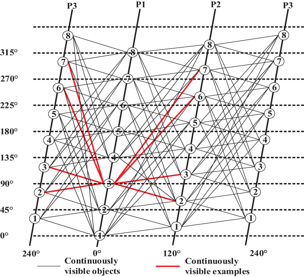
Topology of a non-transitory link in a non-time-varying link.
Within a return period of 168 h, the distribution of MEO satellites in China was analyzed in hours. Calculating by the minimum elevation angle of 10° at the typical ground stations such as Weinnan, Sanya, Kashi, and Beijing, a maximum of 14 MEO satellites can be seen in the country. The Weinan Station is used as an example. The number of MEO satellites that can be seen during a return period is shown in Figure 2.
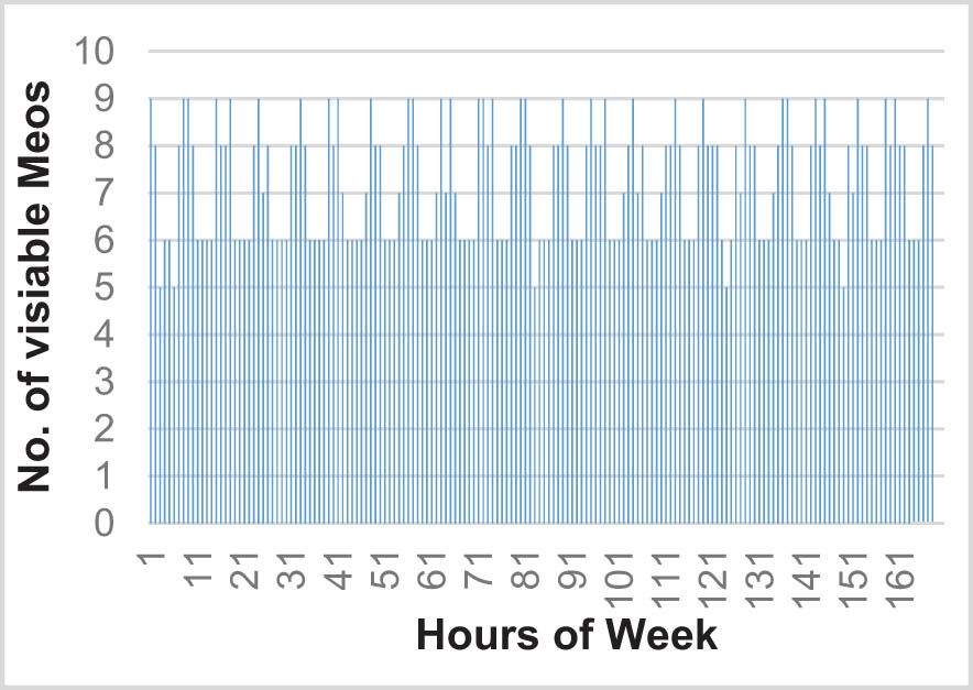
The number of visible MEO satellites in the Weinan station.
3.2.2 IGSO Visibility analysis
According to the analysis, GSO and all MEO satellites are intermittently visible. For the MEO satellite acting as the link building target, the cumulative visible time every 7 days is approximately 87–114 h, and the maximum continuous visible time is roughly 16 h. The visibility of P11, P21, and P31 of the I1 satellite and MEO orbit is shown in Figure 3.
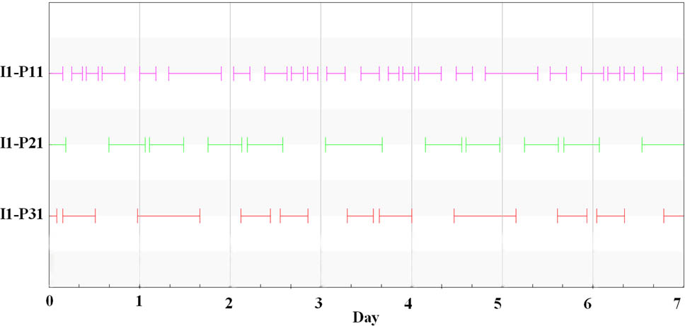
Visible relationship between the IGSO1 satellite and the MEO satellite.
The visible time of IGSO and ground stations (calculated at the minimum elevation angle of 10°) varies depending on the latitudes of the ground stations. The visible time of typical stations is shown in Table 1.
Visible time of the IGSO to ground station
| Ground station | IGSO Visible time per day (h) | Proportion (%) |
|---|---|---|
| Weinan | 17.9 | 74.6 |
| Sanya | 21.8 | 90.8 |
| Kashi | 17.1 | 71.3 |
| Beijing | 17.0 | 70.8 |
3.2.3 GEO visibility analysis
The GEO satellite and all MEO satellites are intermittently visible, and the cumulative visible time every 7 days is approximately 100 h. The visible relationship between MEO orbits P11, P21, and P31 is displayed in Figure 4.
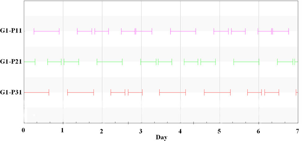
Visibility of the G1 satellite to the MEO satellite.
GEO satellites are geostationary satellites, and ground station visibility can only be categorized as continuous visibility and invisibility. According to the analysis, the elevation angles of the three GEO satellites with respect to Weinan, Beijing, Sanya, and Kashi are all greater than 10°, and they are all continuously visible.
3.3 Link allocation design
For the inter-satellite links of the navigation constellation, the visible conditions of the inner-satellites laser links and satellites-ground high-speed Ka links are not static. Moreover, the visible conditions between nodes may change over time. Based on the idea of the FSA (Yan et al. 2015), the cycle of navigation satellite network systems is divided into multiple equal-length time intervals. Each time interval corresponds to a specific FSA state. If two satellites are always visible in a particular FSA state, it is defined that two satellites are visible in this state. Otherwise, they are not visible. In this manner, changing visibility is converted into a series of fixed visibility, and link allocation is performed based on fixed visibility in different FSA states. Therefore, the topology routing plan must be based on the visibility matrix between nodes. The procedure is shown in Figure 5.
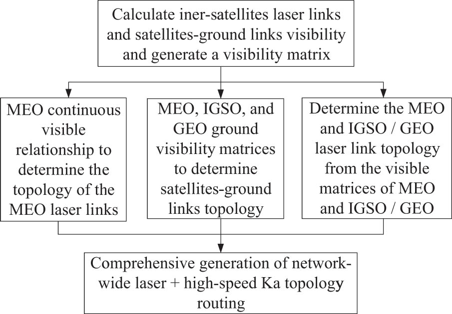
The basic process of laser inter-satellite link topology routing planning.
First, the satellite–satellite and satellite–ground visibility matrices are calculated using the ephemeris forecast position of the satellite in conjunction with the movable range of the satellite–satellite laser terminals as well as the movable range of the satellite–ground high-speed Ka link terminals.
Second, the laser link topology and the high-speed Ka link topology are calculated independently. For MEO satellites, selecting visible targets for topology planning for link building targets can reduce the risk of switching and recapture laser terminal pointing. For the intermittent visibility of MEO and IGSO/GEO satellites, the topology planning is successively conducted according to different periods. For the MEO and IGSO/GEO satellites, as well as the ground equipment, the topology planning is performed sequentially.
Finally, comprehensive laser topology planning and high-speed Ka link planning are combined to form a complete topology routing planning with different periods.
3.3.1 Establish a visibility matrix
The virtual static topology map construction method is utilized in the GEO, IGSO satellite, and MEO satellite link building models. According to the visibility and periodicity of the constellation operation, the cycle of the entire constellation is divided into periods with equal intervals. Within each period [t k , t k+1], the visibility of the GEO, IGSO, and MEO can be abstracted in advance as a static matrix V k . v G1 P11 represents the visual relationship between GEO1 and P11 phase MEO. When v G1 P11 = 1, the GEO1 satellite and P11 phase MEO satellite are visible; when v G1 P11 = 0, they are not visible.
Similarly, v I1 P11 indicates the visible relationship between the IGSO1 satellite and the P11 phase MEO. A value of 1 indicates visibility, and a value of 0 indicates non-visibility.
The static matrix V k of each period is obtained. Time forward recurrence is applied to obtain intersection ∩V k , and the iteration stops when the following conditions are met:
The significance of the preceding condition characterization is selecting the longest period. Thus, the satellite chain relationship and topology routing can be maintained. Each GEO satellite meets the requirement of establishing a link with at least a single MEO and no more than two MEO satellites. IGSO satellites with spare beams should build a link with a single MEO satellite, and each MEO satellite can establish a link with at most one GEO or IGSO satellite.
3.3.2 Optimization algorithm based on Dijkstra
According to the link-building model, solving the constellation topology routing is done by employing the periodicity and predictability of the satellite network topology to select a time point that meets certain conditions. During this period, the constellation topology and the link transmission cost are considered constants. In other words, the consecutive topology routing transformations in a constellation transformation period is discretized into a series of static network topologies. The static network topology corresponds to a weighted undirected graph. According to the visible conditions of the satellites, values of 〈ISLk = (Sk, Gk)〉 are calculated in advance, where Sk represents the inter-satellite link building relationship matrix, and Gk is the satellite-ground link building relationship matrix. In this article, the weighted undirected graph corresponds to each period. The optimized Dijkstra algorithm is used to search and calculate the route (Zhang and Liu 2006) to reduce path congestion and generate each static network topology table.
3.3.2.1 Link reading
The link building is a matrix structure, which is saved in a file format. In this format, the rows and columns represent the names of the satellites, and the matrix elements crossing the rows indicate whether or not the two satellites are linked. If the value of 1 is obtained, the two satellites are linked. If the value of 0 is obtained, the two satellites are not linked.
3.3.2.2 Node satellite reading
Thirty satellites are involved in the link building, including 24 MEO satellites, 3 GEO satellites, and 3 IGSO satellites. Node satellites are satellites that are directly connected to the ground equipment. Three GEO satellites, three IGSO satellites, and domestic MEO satellites are typically used. Other satellites involved in the link building are non-node satellites.
3.3.2.3 A link graph construction
To describe the state of the inter-satellite network, an undirected graph G is constructed with satellites as nodes and inter-satellite links as edges.
3.3.2.4 Path search
In graph G, the path from each non-node satellite to each node satellite is investigated, and each satellite passing through each path is recorded. During the search, the starting point of the path is a non-node satellite, the end of the path is a node satellite, and the passing satellites are also non-node satellites. The Dijkstra algorithm is used to obtain the shortest paths from each non-node satellite to each node satellite, and each satellite passing through each path is recorded.
3.3.2.5 Path selection
After obtaining all shortest paths, only a single path is required from each non-node satellite to each node satellite. Thus, it is necessary to select a single path from multiple options. The load balancing of each satellite required special attention when choosing a path. The number of paths passing through each satellite is recorded as its load value. During path selection, the sum of the load values of other satellites (excluding the head and tail nodes of each path) is calculated as the value of path congestion. Among the multiple paths from each non-node satellite to each node satellite, the one with the smallest path congestion is selected. After the path selection is completed, the path is updated with the load values of other satellites (except for the head and tail ones).
3.3.3 Alternative routing policy
The topology structure, which will destroy the link due to node failure or communication interruption, must be considered. Thus, the algorithm should establish not only the main path but also many other alternative paths to ensure connectivity and stability of the entire constellation. Once some nodes fail, alternative paths can be used to complete the task.
There are many optional routes for each target MEO satellite in the constellation routing table. Among these optional routes, the routes that share no common routing with other links in the shortest path are referred to as link-unrelated routes. To improve reconstruction capabilities and reduce transmission and reception interference among multiple paths, a link-unrelated route represents a more appropriate selection for the alternative path.
The procedure for generating alternative route sets at each moment is as follows: First, the shortest routing is found by the shortest path search algorithm. Then, the routing is excluded, and the second-best routing is found by the shortest path search algorithm. This procedure is repeated until all alternative routes are identified.
4 Simulation verification
The satellite position information contained within the entire network ephemeris is utilized in the topology generation process. According to the requirements for the capture time, the communication time of laser inter-satellite links, the entire network connectivity, and the effective time range of the ephemeris, the 7-day constellation orbit cycle is divided into 168 states with 1 h time intervals. Simultaneously, during the operation of the satellites, both the PDOP value and the delay of the inter-satellite link are continuously changed. However, to simplify the calculation and analysis, the simulation process uses a 1-min sampling cycle for the constellation data.
4.1 Inter-satellite PDOP value
There is currently no uniform standard for evaluating inter-satellite measurement. Satellite positioning theory can be used as a reference. Inter-satellite measurement is considered a user-oriented satellite positioning process. PDOP is used to evaluate the performance of inter-satellite links. The value of PDOP is used to determine if the current inter-satellite link has a good geometric distribution (Dong et al. 2018a,b). MEO, GEO, and IGSO are considered equivalent nodes in the algorithm (Gao 2018). The PDOP values of all satellites are counted according to the link-building planning of a regression cycle. The results indicate that the PDOP value ranges for MEO, GEO, and IGSO are 0.802–1.190, 1.300–2.295, and 1.319–2.30, respectively, as shown in Figure 6. These values meet the measurement requirements.
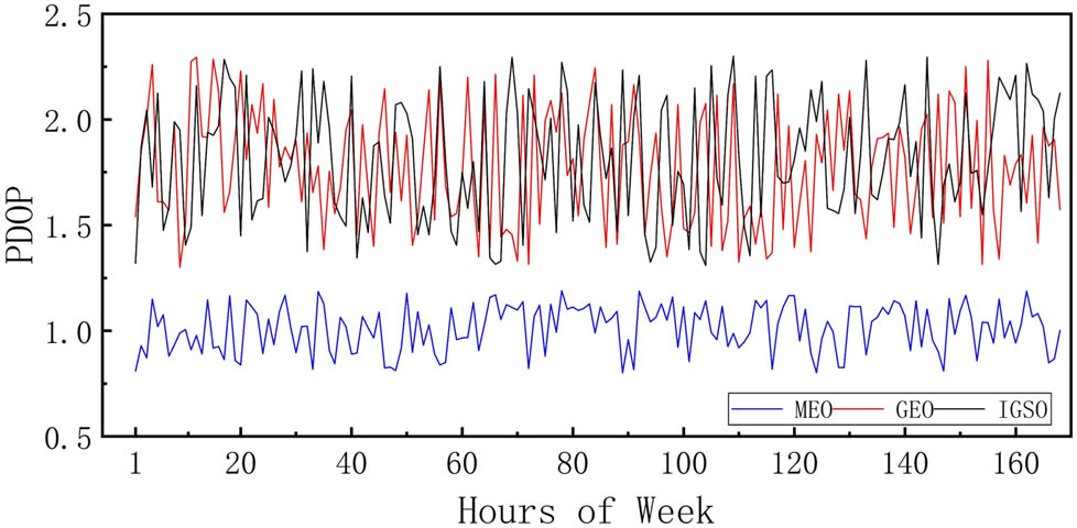
PDOP of the MEO, GEO, and IGSO in a single week.
4.2 Inter-satellite transmission delay
The inter-satellite transmission delay specifically includes the waiting delay, the sending delay, and the propagation delay. Since the waiting delay occupies most of the total delay time (Dong et al. 2018a,b, Wang et al. 2021, Guo et al. 2021, Lei 2020, Shi et al. 2021, Wang et al. 2020, Cinelli et al. 2021), only the waiting delay is considered to reduce the simulation complexity. Based on the full constellation orbit data of a regression period and the location of the ground station site, a routing table within a regression period is derived by adhering to the design principles and ideas. Regardless of the onboard data processing time, statistics on the delays of MEO, GEO, and IGSO over a period of time are shown in Figure 7.
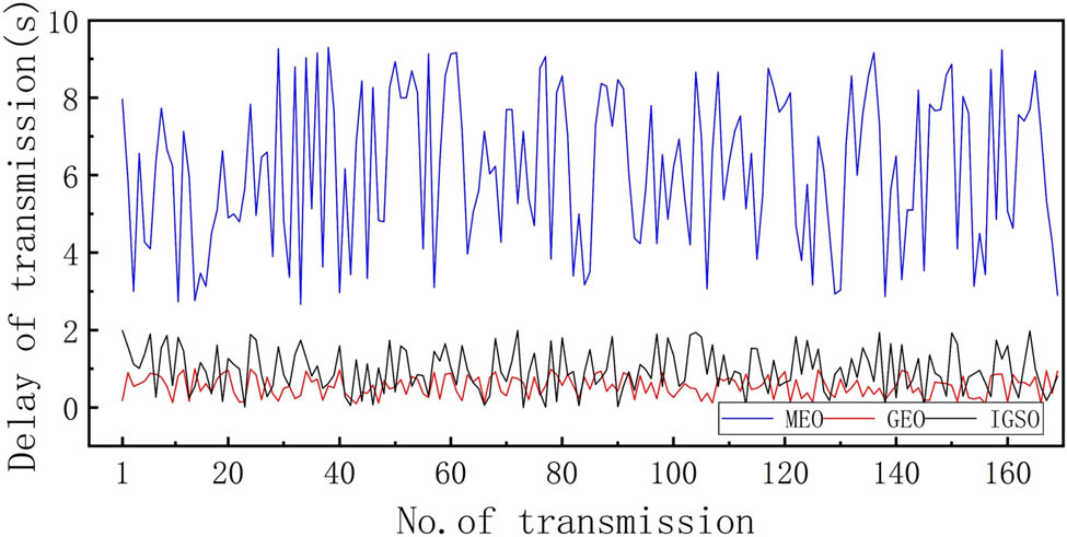
Transmission delay of the MEO, GEO, and IGSO.
The average delays of the MEO, GEO, and IGSO are 5.97, 0.55, and 1.01 s, respectively. Thus, they meet the demands for the data transmission delay.
4.3 Link switching analysis
Weinan, Sanya, Kashi, and Beijing are selected as ground receiving stations for a periodic simulation. The link switching is divided into four distinct cases. In Case 1, the routing and node satellites in the following hour remain the same as those in the previous hour. In Case 2, the routing and node satellites for the following hour remain the same as those for the previous hour, but the ground station corresponding to the node satellite is changed. In Case 3, the next hour’s routing remains the same as the previous hour’s, but the node satellite is changed. Finally, in Case 4, both the routing and node satellites of the following hour and the previous hour have changed.
The total link switching times of each station are counted. During the regression period, a maximum of three routing hops exist. The total number of routings remains unchanged for 57 h (corresponding to Case 1), and the maximum duration is 3 h. The routing remains unchanged for a total of 12 h, and the reconfiguration is completed by modifying stations (corresponding to Case 2). The routing packets remain unchanged for a total of 90 h, and the reconfiguration is completed by changing the direction of data transmission (corresponding to Case 3). Reconstruction requires a total of 9 h of re-planning (corresponding to Case 4). Based on the conducted analysis, the probability of the overall routing reconfiguration is only 5.4%, which greatly simplifies the management of the inter-satellite link.
5 Conclusion
This article proposes a feasible link-building solution for the slowly varying continuous duplex inter-satellite link system. In addition, measurement and control requirements for the inter-satellite link are also provided. The visibility of inter-satellite links is analyzed based on laser link and high-speed Ka link, and the topology design principles and routing planning principles of the high-speed inter-satellite link are formulated. Each inter-satellite link-building node’s connection pre-allocation is accomplished using the finite state machine method and the optimized Dijkstra algorithm. The proposed model can meet the requirements of navigation constellation for link-building in terms of measurement, data transmission, and management. In addition, it can be used as a reference for the construction of high-speed inter-satellite links for the navigation constellation.
-
Funding information: The authors state no funding involved.
-
Author contributions: All authors have accepted responsibility for the entire content of this manuscript and approved its submission.
-
Conflict of interest: The authors state no conflict of interest.
References
Chang HS, Kim BW, Lee CG, Min SL, Choi Y, Yang HS, et al. 1998. FSA-based link assignment and routing in low-earth orbit satellite networks. IEEE Trans Veh Technol. 47(3):1037–1048.10.1109/25.704858Search in Google Scholar
Cinelli M, Ortore, E, Laneve, G, Circi C. 2021. Geometrical approach for an optimal inter-satellite visibility. Astrodynamics. 5:237–248.10.1007/s42064-020-0099-0Search in Google Scholar
Dang YM, Mi JZ, Cheng YY. 2007. Principles and applications of global navigation satellite system. Beijing: Mapping Press.Search in Google Scholar
Dong MJ, Lin BJ, Liu YC, Zhou LS. 2018a. Topology dynamic optimization for inter-satellite laser links of navigation satellite based on multi-objective simulated annealing method. Chinese Journal of Lasers. 45(7):217–222.10.3788/CJL201845.0706004Search in Google Scholar
Dong MJ, Lin BJ, Liu YC, Zhou LS. 2018b. Visibility algorithm for navigation satellite intersatellite laser links under constraint conditions. Optical Communication Technology. 42(5):57–61.Search in Google Scholar
Gao H. 2018. Research on inter satellite link allocation method of Beidou navigation system, Master’s thesis, Hunan University, Changsha, China. p. 28–31.Search in Google Scholar
Guo S, Zhou W, Zhang J, Sun F, Yu D. 2021. Integrated constellation design and deployment method for a regional augmented navigation satellite system using piggyback launches. Astrodynamics. 5:49–60.10.1007/s42064-020-0091-8Search in Google Scholar
He JF, Jiang Y. 2009. A walker constellation network topology and routing generation scheme with extraterrestrial links, Master’s thesis, PLA University of Science and Technology, Nanjing.Search in Google Scholar
Lei H. 2020. Dynamical models for secular evolution of navigation satellites. Astrodynamics. 4:57–73.10.1007/s42064-019-0064-ySearch in Google Scholar
Liu Z, Guo W, Deng CL, Hu WS, Chen H, Zhao YB, et al. 2014. Perfect match model based link assignment for optical satellite network. 2014 IEEE International Conference on Communications. pp. 4149–4153.10.1109/ICC.2014.6883971Search in Google Scholar
Shi LY, Xiang W, Tang XM. 2011. A link allocation algorithm for inter satellite observation and communication of satellite navigation system. Acta Astron Sin. 32(9):1971–1977.Search in Google Scholar
Shi R, Long T, Ye N, Wu Y, Wei Z, Liu Z. 2021. Metamodel-based multidisciplinary design optimization methods for aerospace system. Astrodynamics. 5:185–215.10.1007/s42064-021-0109-xSearch in Google Scholar
Sun H, Hao XP, Feng WQ, Yin J. 2011. Inter-satellite links topology scenario based on minimum PDOP criterion. Journal of Beijing University of Aeronautics and Astronautics. 37(10):1245–1249.Search in Google Scholar
Wang DH. 2014. Research on navigation inter-satellite links networking to optimize ranging and communication, PhD thesis, National University of Defense Technology, Changsha, China.Search in Google Scholar
Wang W, Gao WG, Tang CP, Ye XZ, Lu Y, Liu C, et al. 2021. Research and verification of the autonomous navigation technology of GNSS. Scientia Sinica: Physica Mechanica et Astronomica. 51:019511.10.1360/SSPMA-2020-0236Search in Google Scholar
Wang Y, Chen X, Ran D, Zhao Y, Chen Y, Bai Y. 2020. Spacecraft formation reconfiguration with multi-obstacle avoidance under navigation and control uncertainties using adaptive artificial potential function method. Astrodynamics. 4:41–56.10.1007/s42064-019-0049-xSearch in Google Scholar
Yan HC, Zhang QJ, Sun Y. 2015. Link allocation of navigation satellite network with limited number of inter satellite links. J Aeronaut. 36(7):2329–2339.Search in Google Scholar
Yang YF, Yang YX, Hu XG. 2019. Comparative analysis of the accuracy of two orbit determination modes of BeiDou-3 satellite. J Survey Map. 48(7):831–839.Search in Google Scholar
Yu KM, Li YJ, Wu JL, Hong H, Yi P. 2010. Space caracteristic simulation of Optical Inter-satellite Links in multi layer satellite networks. Telecommun Eng. 50(10):87–92.Search in Google Scholar
Zhang T, Liu CK. 2006. Research on shortest path algorithm of satellite time-varying network topology. J Computer Sci. 29(3):71–377.10.1007/s10915-021-01482-3Search in Google Scholar
Zhou ZH. 2015. Research of inter-satellite link assignment of LEO satellite networks, Master’s thesis, Nanjing University of Posts and Telecommunications, Nanjing, China.Search in Google Scholar
© 2022 Canyou Liu et al., published by De Gruyter
This work is licensed under the Creative Commons Attribution 4.0 International License.
Articles in the same Issue
- Research Articles
- Deep learning application for stellar parameters determination: I-constraining the hyperparameters
- Explaining the cuspy dark matter halos by the Landau–Ginzburg theory
- The evolution of time-dependent Λ and G in multi-fluid Bianchi type-I cosmological models
- Observational data and orbits of the comets discovered at the Vilnius Observatory in 1980–2006 and the case of the comet 322P
- Special Issue: Modern Stellar Astronomy
- Determination of the degree of star concentration in globular clusters based on space observation data
- Can local inhomogeneity of the Universe explain the accelerating expansion?
- Processing and visualisation of a series of monochromatic images of regions of the Sun
- 11-year dynamics of coronal hole and sunspot areas
- Investigation of the mechanism of a solar flare by means of MHD simulations above the active region in real scale of time: The choice of parameters and the appearance of a flare situation
- Comparing results of real-scale time MHD modeling with observational data for first flare M 1.9 in AR 10365
- Modeling of large-scale disk perturbation eclipses of UX Ori stars with the puffed-up inner disks
- A numerical approach to model chemistry of complex organic molecules in a protoplanetary disk
- Small-scale sectorial perturbation modes against the background of a pulsating model of disk-like self-gravitating systems
- Hα emission from gaseous structures above galactic discs
- Parameterization of long-period eclipsing binaries
- Chemical composition and ages of four globular clusters in M31 from the analysis of their integrated-light spectra
- Dynamics of magnetic flux tubes in accretion disks of Herbig Ae/Be stars
- Checking the possibility of determining the relative orbits of stars rotating around the center body of the Galaxy
- Photometry and kinematics of extragalactic star-forming complexes
- New triple-mode high-amplitude Delta Scuti variables
- Bubbles and OB associations
- Peculiarities of radio emission from new pulsars at 111 MHz
- Influence of the magnetic field on the formation of protostellar disks
- The specifics of pulsar radio emission
- Wide binary stars with non-coeval components
- Special Issue: The Global Space Exploration Conference (GLEX) 2021
- ANALOG-1 ISS – The first part of an analogue mission to guide ESA’s robotic moon exploration efforts
- Lunar PNT system concept and simulation results
- Special Issue: New Progress in Astrodynamics Applications - Part I
- Message from the Guest Editor of the Special Issue on New Progress in Astrodynamics Applications
- Research on real-time reachability evaluation for reentry vehicles based on fuzzy learning
- Application of cloud computing key technology in aerospace TT&C
- Improvement of orbit prediction accuracy using extreme gradient boosting and principal component analysis
- End-of-discharge prediction for satellite lithium-ion battery based on evidential reasoning rule
- High-altitude satellites range scheduling for urgent request utilizing reinforcement learning
- Performance of dual one-way measurements and precise orbit determination for BDS via inter-satellite link
- Angular acceleration compensation guidance law for passive homing missiles
- Research progress on the effects of microgravity and space radiation on astronauts’ health and nursing measures
- A micro/nano joint satellite design of high maneuverability for space debris removal
- Optimization of satellite resource scheduling under regional target coverage conditions
- Research on fault detection and principal component analysis for spacecraft feature extraction based on kernel methods
- On-board BDS dynamic filtering ballistic determination and precision evaluation
- High-speed inter-satellite link construction technology for navigation constellation oriented to engineering practice
- Integrated design of ranging and DOR signal for China's deep space navigation
- Close-range leader–follower flight control technology for near-circular low-orbit satellites
- Analysis of the equilibrium points and orbits stability for the asteroid 93 Minerva
- Access once encountered TT&C mode based on space–air–ground integration network
- Cooperative capture trajectory optimization of multi-space robots using an improved multi-objective fruit fly algorithm