
Multihazard susceptibility assessment: A case study – Municipality of Štrpce (Southern Serbia)
-
Uroš Durlević
 ,
Ivan Novković
,
Ivan Novković

Abstract
The municipality of Štrpce (Southern Serbia) is an area located within Šar Mountain National Park, which is of great ecological importance. Due to the vicinity of settlements, it is necessary to analyze the terrain's susceptibility to natural hazards. The main goal of this research was to determine locations that are highly vulnerable at times of natural hazards (such as earthquakes, erosion, torrential flooding, snow avalanches, and forest fires). The first step in this research was to analyze seismic hazards for a 475 years return period (VII–VIII MCS for the observed area), which was possible by means of Geographic Information Systems. The second step was to determine the intensity of erosion and total sediment production using the Erosion Potential Model. The third step was related to the analysis of the potential of torrential floods using the Flash Flood Potential Index. The Avalanches Potential Index method was used as the fourth step. The fifth step included the analysis of a terrain susceptibility to the occurrence of forest fires. Following the five criteria analysis, weight coefficients were assigned to each of the analyzed parameters by using the Analytical Hierarchy Process (AHP), which provided results of the total susceptibility to natural hazards of the territory of Štrpce. Results indicated that over 45% of the municipality is highly or very highly susceptible to various natural hazards. This article represents a significant step toward a better understanding of natural hazards and it provides a unique knowledge basis for establishing the management and mitigation guidelines and measures, not only within the researched area but at regional and national levels as well.
1 Introduction
Serbia is a continental country located in Southeast Europe, in the Balkan Peninsula with an area of 88.361 km2. Due to its specific geographical position in the southeast part of the Pannonian Basin, it was often faced with different types of natural disasters, for more than 100 years of observation. In the period from 1900 to 1940, there were 100 natural disasters in every decade. Between 1960 and 1970 there were 650 natural disasters, between 1980 and 1990 their number reached 2,000, while during the 10 year period between 1990 and 2000, the number of disasters increased to even 2,800 [1]. The investigation of Natural hazards has a long history. The term itself refers to various agents that encompass geological and hydro-meteorological processes in the area [2,3]. However, many authors define natural disasters as sudden events, caused by significant human activities [4,5].
Natural hazards may present a great threat for the community depending on the magnitude of events. The municipality of Štrpce is located in the southern part of the Province of Kosovo and Metohija. This location belongs to one of the most beautiful National Parks of Serbia. Unfortunately, this area was often hit by natural hazards in the past, especially by earthquakes and erosion processes. The diversity of flora and fauna in this area can be threatened by the effects of natural disasters, as well as by the anthropogenic impact. Recently, human activity is in connection with environmental impacts. The municipality of Štrpce, being the most important settlement in the area, would be seriously jeopardized by hazardous events. With the help of advanced Geographical Information System (GIS) methods and remote sensing, erosion, torrential floods, snow avalanches, and forest fires were analyzed [6,7,8].
Multihazard techniques are very important for the analysis of hazardous events [9,10,11,12,13,14]. Another approach could be approved by probabilistic and deterministic stochastic processes [15]. These processes are implemented in the algorithms of Quantum Geographical Information Systems (QGIS). Earthquake magnitude and its effects are estimated by means of specific seismic hazard analysis [16,17].
The territory of Serbia has 86% of the area with a potential for soil erosion of different volumes and intensities [18,19,20,21]. Šar Mountain foothills are known as very seismically active zone. Štrpce municipality has 11,000–12,000 inhabitants and its settlements are distributed on different slopes and mountain areas. In this investigated area, soil erosion is the main factor that may cause a big problem for the settlements. According to Ristanović et al. [22], acceleration of the process of soil erosion can cause a potential problem for agriculture. The soil erosion may be doubled with an increase of slope and relative angle of terrain [23,24,25,26].
Torrential floods are recognized as one of the most devastating natural hazards affecting the lives of many people in central and southern Serbia [22]. The damage caused by floods is extremely difficult to assess because it is very difficult to measure it [27,28,29,30,31,32,33]. In the past, torrential floods caused great economic damage to the local population of the municipality of Štrpce, especially in the period between 1953 and 1979 [34]. On the Šar Mountain, snow avalanches often cause great economic damage to the local population in the tourist zone of Brezovica Ski Center.
According to the last climate changes variability in Serbia, the number of forest fires displays an increasing tendency in southeastern Europe and Serbia. Šar Mountain is very vulnerable in the case of forest fires. Spatial planning and protection of forests have become very important tasks [35]. GIS and spatial data modeling are very powerful tools for calculating and describing the data of hazardous effects [36,37,38].
This research develops a new methodology for the predisposition of terrain to snow avalanches by means of GIS algorithms and multicriteria analysis and it represents one of the first investigations for avalanches based on modern techniques. There are many research studies that included GIS and remote-sensing techniques and estimation of hazards. The GIS can help to reduce the impact of natural hazards [28,33].
GIS flood risk mapping may be very important for the analysis of flood risk. Multicriteria analysis was successful in estimating the flooding waves. A good example is set through the case study of the Quang Tho Commune in Thua Thien Hue province, central Viet Nam [39]. Disasters vary drastically depending on the local context. Namely, the probability of a natural disaster having more devastating effects in one place than in another depends on the local vulnerability components of the affected society (cultural, social, and economic). The socioeconomic indicators may be used for mapping the social vulnerability index after earthquake effects. The GIS approach was applied to identify the spatial variability of social vulnerability to seismic hazards. The example of seismic hazards after Volcano activity was performed by GIS numerical methods in Italy [40]. The Karmania Hazard Model is a GIS-based application for earthquake scenario development and disaster management. This model, created to solve earthquakes during the disaster response phase, motivated the design and implementation of a comprehensive, interactive, and user-friendly model [41]. The research gave new ecological and socioeconomic results. The main goal of this research is to predict hazardous events likely to happen in the future.
2 Methods and data
2.1 Study area
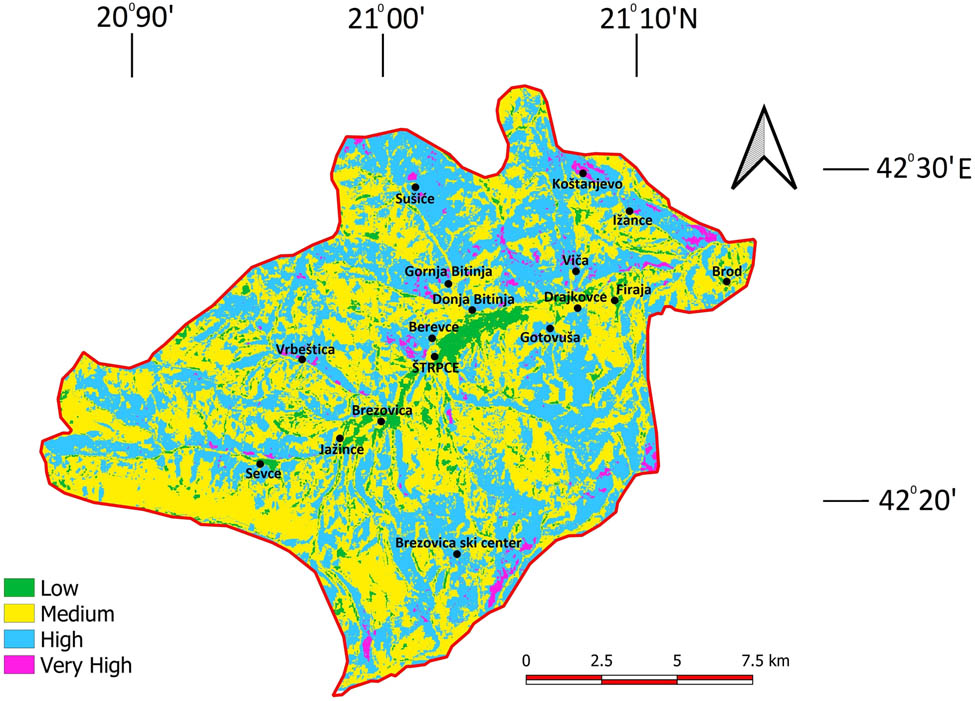
As already mentioned, the research area includes the municipality of Štrpce, which is located in the southernmost part of the Republic of Serbia, on the territory of the Autonomous Province of Kosovo and Metohija. The municipality includes 16 settlements: Brod, Ižance, Firaja, Drajkovce, Viča, Koštanjevo, Gotovuša, Gornja Bitinja, Donja Bitinja, Sušiće, Štrpce, Berevce, Brezovica, Vrbeštica, Jažince, and Sevce (Figure 1). Currently, the population of the municipality numbers between 11,000 and 12,000 people, who are mainly engaged in quaternary activities (education, healthcare, and administration), agriculture (raspberry growing), and tourism. Tourism relies on Brezovica Ski Center, offering ideal conditions for recreational and alpine skiing.
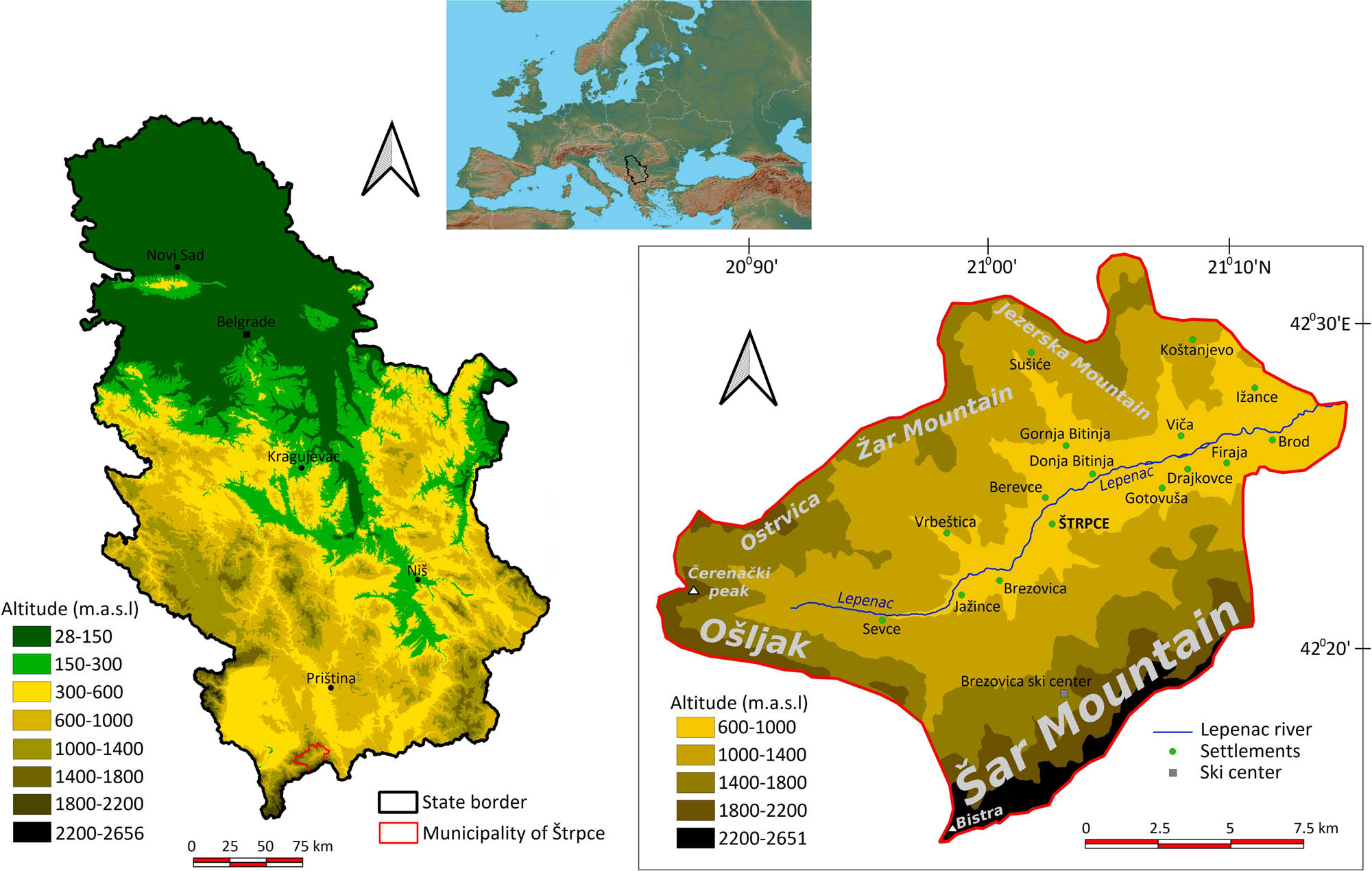
Geographical location of the municipality of Štrpce.
The municipality is located in the upper course of the Lepenac River basin, covering an area of approximately 248 km2. In geographical terms, it is known as Sirinićka župa. Morphologically and geographically, the municipality borders with Šar Mountain and its branches: Ošljak, Čerenački peak, Ostrvica, Žar, and Jezerska Mountain, which gives the impression of its natural isolation [34,42]. The lowest altitude in the municipality is 600 m, while the highest peak is Bistra (Peskovi), the second-highest peak in Serbia, with an altitude of 2,651 m. In terms of lithological composition, 13 types of rocks have been identified on the municipality’s territory, out of which the most common are metamorphic rocks, diabase-hornstone formation, and Mesozoic carbonate rocks, together covering more than 77% of the municipality area. When it comes to pedological cover, various factors have contributed to creating numerous soil types and subtypes, with the most common being dystric cambisols, alluvial–diluvial soils, rankers, rendzinas, lithosols, kalkocambisols, diluviums, terra rossa, and brown soil on igneous rocks [34]. As far as land use is concerned, the area is dominated by deciduous forests and woody–shrubby vegetation. Nonirrigated agricultural areas, meadows, and agricultural plots with natural vegetation are frequent around the settlement. This area has a temperate-continental climate. Mean annual temperatures differ depending on the terrain morphometric characteristics. In the southern part of the municipality, at the peaks of Šar Mountain, the average annual temperature is less than 1°C, while in the lowest parts of the municipality, the average annual temperature reaches 11°C. The annual precipitation varies from 500 mm in the lowest, eastern part of the municipality, to 1,250 mm in the south, on the slopes and peaks of Šar Mountain. During the winter months, the snow depth on Šar Mountain is often more than 1 m, with snow remaining until July and August in some parts. The Šar Mountain National Park is one of the most significant biogeographical areas in Europe. According to the Institute for Nature Conservation of Serbia, this area is inhabited by 1,800 plant species, of which 339 are Balkan endemics and 18 are local endemics. Moreover, 147 species of diurnal butterflies, 45 species of amphibians and reptiles, about 200 species of birds, and 32 species of mammals have been identified, making this area exceptionally valuable in terms of flora and fauna.
3 Methodology
By applying the previously defined multihazard methodologies, it was possible to conduct scientific research and analysis of the study area’s susceptibility to natural hazards.
3.1 Seismic hazard
Seismic hazard data for the 475 year return period in the municipality of Štrpce was taken from the Serbian Institute of Seismology database (http://www.seismo.gov.rs). In the GISs, the value was assigned based on intensity (VII–VIII and VIII MCS), which was later used for modeling the total susceptibility to natural hazards.
3.2 Soil erosion
Nowadays, depending on the database size and satellite images availability, it is possible to determine a degree of erosion intensity and total sediment production by the office work via GIS software packages and later confirm it by fieldwork. By applying an available database and by using the Erosion Potential Model (EPM) model, erosion risk for the territory of the municipality of Štrpce was assessed. By analyzing and processing the most up-to-date data for the researched area, an average erosion coefficient, as well as the total and specific sediment production, were obtained.
Specific annual production of erosion deposits in a catchment area was acquired by dividing the total production of erosion deposits by the catchment area.
As indicated by Ristanović et al. [22], the most widespread model in the Western Balkan countries is the so-called EPM, also known as the Gavrilovic method [43], because it corresponds well with the USLE model used for a wider area of Europe. For the analysis of the state of erosion and sediment production on the territory of the municipality of Štrpce, the applied formula was the one according to which the total sediment production in the catchment area is calculated by the following equation [43]:
where W anu represents the total sediment production (m3/year), T the temperature coefficient, H anu the average annual rainfall in mm, Z an erosion coefficient, and Fa the catchment area in km2.
The EPM model belongs to the group of regional methods, and in the widely spread literature, it is characterized as a semiquantitative method [44,45].
The temperature coefficient (T) is given by the following equation [43]:
where t represents an average annual air temperature (°C), obtained by analyzing the dependence of changes in temperature on the changes in altitude by using the data from relevant meteorological stations in the region of Metohija, based on the following equation [46]:
where t represents an average annual air temperature and H represents a value (in m) obtained through the Digital Elevation Model (DEM).
The average annual precipitation of H anu is obtained by analyzing the dependence of changes in precipitation from relevant precipitation stations in the municipality, based on the following formula [46]:
where H anu is an average annual rainfall and H (m) is a value obtained through the DEM. The erosion coefficient (Z) is calculated on the basis of the following formula [43]:
where Z represents an erosion coefficient; Y the coefficient of soil resistance to erosion; X the coefficient of soil protection from atmospheric factors and erosion; ϕ the coefficient of a type of erosion; and I an average drop in the surface area for which erosion coefficient is calculated.
The coefficient of soil resistance to erosion (Y) was obtained by analyzing a pedological map on the scale of 1:50,000. Depending on the degree of pedological base resistance, the coefficient is classified in the range 0.1–1, with the lowest coefficients having the highest resistance, in this case, lithosol. The highest coefficient belongs to a bulk soil that is the most susceptible to erosion (Table 1).
Coefficient of soil resistance to erosion [43]
| Soil type | Y |
|---|---|
| Fluvisol | 0.55 |
| Diluvium | 0.80 |
| Lithosol | 0.40 |
| Dystric cambisol | 0.80 |
| Kalkocambisol | 0.60 |
| Brown soil on igneous rocks | 0.70 |
| Ranker | 0.80 |
| Rendzina | 0.65 |
| Terra rossa | 0.80 |
The coefficient of soil protection from atmospheric factors and erosion (H) was obtained by processing and analyzing a geospatial database on land use – Corine Land Cover (2018), which is published by the European Environment Agency (EEA). In the range of 0.1–1, the highest coefficient is assigned to vegetation-free areas dominated by stronger types of erosion. Due to the extremely developed root system, the good composition of forests is contributing to a large amount of precipitation and to the reduction of erosion intensity. Nonirrigated agricultural areas and areas with sparse vegetation are very prone to erosion effects (Table 2).
Coefficient of land use types
| Substrate protection coefficient | X |
|---|---|
| Discontinuous urban fabric | 0.25 |
| Nonirrigated arable land | 0.80 |
| Pastures | 0.50 |
| Land principally occupied by agriculture, with significant areas of natural vegetation | 0.55 |
| Broad-leaved forest | 0.20 |
| Coniferous forest | 0.15 |
| Mixed forest | 0.15 |
| Natural grasslands | 0.40 |
| Moors and heathland | 0.50 |
| Transitional woodland-shrub | 0.40 |
| Sparsely vegetated areas | 0.90 |
The coefficient of a type of erosion (ϕ) was determined by using the Bare-Soil Index (BSI). Multispectral satellite images from Landsat 8 satellite, which belongs to the United States Geological Survey, were used for obtaining this index. Recordings for 2015, 2017, and 2019 were analyzed and so the final result represents an average BSI used to analyze the erosion intensity. The remote detection technique is very important in the field of regional soil erosion assessment [47,48,49,50,51]. This index enables easier and more efficient erosion intensity calculation. The BSI is obtained by using the following formula [52]:
where B6 (Band 6) is a shortwave infrared spectral channel (SWIR 1), B4 (Band 4) is a red spectral channel, B5 (Band 5) is a near-infrared spectral channel (NIR), and B2 (Band 2) is a blue spectral channel.
An average slope of terrain (√I) was obtained by using the DEM with a resolution of 25 m, in the form of percentage expressed in decimals. EU-DEM was taken from the website of the EEA’s Copernicus program [53]. It is important to note that in line with the slope increases, the slope stability decreases, while erosion intensity increases as well as torrential floods occurrence probability [54].
3.3 Torrential floods
For the area of the municipality of Štrpce, an analysis of terrain predisposition for the occurrence of torrents was conducted using GIS.
The method used for torrential floods was the Flash Flood Potential Index (FFPI). This method is most commonly used in the world and the region [55,56,57]. The method was developed at the Colorado Basin River Forecast Center. The FFPI is determined by using GIS software tools through a statistical approach based on the principle of established correlation between different factors and spatial distribution of particular basin drainage, or a research approach, i.e., indexing the weight factors or allocating weighting factor to each factor affecting the occurrence of torrential floods based on empirical experience [58,59,60,61,62]. It was developed primarily because predictions of torrential floods by means of meteorological parameters did not provide satisfactory results, while the connection between the occurrence of this disaster and certain physical–geographical characteristics of territory was not defined. Soil structure and texture are the main characteristics that define water retention and infiltration. Terrain geometry, primarily slope, determines the rate and concentration of the outflow. The percentage of atmospheric water retention on a surface primarily depends on the main characteristics of the vegetation. For example, seasonal changes in the vegetation of deciduous forests significantly affect the possibility of torrential flood development, while in addition to changes in vegetation, forest fires negatively affect the soil, where the power decreases due to the organic matter burning infiltration. Land use and especially urbanization play an important role in the process of water infiltration, concentration, and outflow behavior. Together, these natural conditions provide information on the possibility of torrents occurring in a particular area [58].
The following natural conditions were analyzed in order to identify the likelihood of torrential floods in the municipality of Štrpce: terrain slope, soil types, vegetation density, and land use type.
The FFPI method was obtained based on the following formula [58]:
where M is a terrain slope, S represents soil types, L is the land use, and V represents a BSI.
The terrain slope (M) was obtained by using GIS software packages, based on an EU-DEM with a spatial resolution of 25 m taken from the EEA’s Copernicus program website. First, the slope was calculated, expressed as a percentage, and then the following formula was applied:
where n is a terrain slope expressed in %. If n is greater than or equal to 30%, then the M value is always 10. For the soil type (S) analysis, a pedological map was used on a scale of 1:50,000. The classification of soil types was analyzed depending on the soil type's susceptibility to torrents (Table 3).
Soil type coefficients
| Soil type | S |
|---|---|
| Fluvisol | 3 |
| Diluvium | 8 |
| Lithosol | 6 |
| Brown soil on igneous rocks | 5 |
| Kalkocambisol | 6 |
| Dystric cambisol | 7 |
| Terra rossa | 7 |
| Ranker | 7 |
| Rendzina | 6 |
The highest coefficient was assigned to a soil type that is most susceptible to a torrential flood occurrence.
The land use index (L) was calculated by using the data obtained from a geospatial database of the EEA – Corine Land Cover (2018), where certain land use classes were given values from 1 to 10, depending on the main significant characteristics for the occurrence and development of torrential floods. The most susceptible terrains are nonirrigated agricultural areas and areas with sparse vegetation, which were assigned a coefficient of 9 (Table 4).
Land use coefficients
| Land use | L |
|---|---|
| Discontinuous urban fabric | 4 |
| Nonirrigated arable land | 9 |
| Pastures | 6 |
| Land principally occupied by agriculture, with significant areas of natural vegetation | 7 |
| Broad-leaved forest | 3 |
| Coniferous forest | 2 |
| Mixed forest | 3 |
| Natural grasslands | 5 |
| Moors and heathland | 6 |
| Transitional woodland-shrub | 5 |
| Sparsely vegetated areas | 9 |
The BSI was used for a vegetation density index V. Multispectral satellite images from Landsat 8 satellite were processed to obtain this index. In the field of the regional assessment of soil erosion and torrents, the remote detection technique has great potential and advantages [49,51]. The following formula was used to obtain the V coefficient:
To avoid negative sums, a value of 1 has been added.
3.4 Snow avalanches
In the last 220 years, numerous human lives have been lost. With the tourism development of Brezovica Ski Center and by engaging the mountain rescue service, parts of terrain with a higher risk of avalanches have been marked as unfavorable and skiing-prohibited, in order to provide safety for tourists during the winter and spring period. All prerequisites for the occurrence of avalanches can be divided into two main groups. The first group includes invariable conditions of a position (altitude, relief, geological substrate, slopes and roughness of slopes, aspect, vegetation, and neotectonic activity), while the second group consists of variable, meteorological parameters, such as the current weather situation, snow cover condition, temperature, wind dynamics and direction, clouds, total snow depth, snow structure, etc. [34].
The following formula was used for the analysis of terrain susceptibility to avalanches, depending on the significance of parameters:
where S is the terrain slope, A is an aspect class, R is a terrain roughness class, SN is a snow depth class, and V is the vegetation.
The terrain slope is perhaps the most important parameter for the analysis of susceptibility to avalanches. Slope significantly affects the length and triggering of avalanches. Extremely flat and extremely steep terrains are very unsuitable for the formation of avalanches. Numerous authors stated that avalanches are most common on terrain slopes of 30–60° [63,64], 28–60° [65], and 30–50° [66]. On Šar Mountain, mapped avalanches also appeared at 20°, which is the main reason why the analysis of avalanches for this area included a slope of 20–60°. The terrain slope was obtained by using 25 m resolution DEM.
An important morphometric condition is the terrain aspect or exposure. Based on 25 m DEM, exposure plays a major role in retaining snow cover, depending on terrain insolation. Terrains facing south will be more susceptible to faster snow melting due to a longer effect of solar radiation, while the snow lasts much longer within northern exposure, which favors the formation of avalanches (Table 5).
Terrain exposure and soil roughness classes
| Aspect | Roughness | Value |
|---|---|---|
| Southwest, Southeast, South | 50–100 | 1 |
| West, East | 25–50 | 2 |
| North, Northwest, Northeast | 0–25 | 3 |
Terrain roughness significantly affects the formation and movements of avalanches. Slopes that are overgrown with low (grassy) and sparse vegetation have the least roughness, while such terrains are most suitable for the movement of avalanches. The algorithm is derived from the GDAL DEM utility. Terrain roughness was determined and classified into three classes by using QGIS and DEM software packages. A value of 3 was assigned to terrains with a smooth surface dominated by low vegetation (Table 5).
The basic condition for the formation of avalanches is the existence of a snow cover. In the municipality of Štrpce, especially in Brezovica Ski Center, the snow depth in the winter months often exceeds 1 m. The snowfall on Šar Mountain and the surrounding mountains is frequent, so large amounts of newly fallen snow cannot stably bind to the existing snow, creating preconditions for the avalanche formation.
With increasing snow depth, snow stays on a surface longer and therefore the chances for formation and triggering of avalanches are greater. The 6 months (November–April) snow depth was analyzed for the period between 2007 and 2018 (Table 6). Data for the snow depth calculation were downloaded from the Snow-Forecast database. According to the available data, an average six-month amount of snow cover has been obtained by analyzing the dependence of changes in the amount of the snow cover from locations for which data were available.
Snow depth classes
| Snow depth (cm) | Value |
|---|---|
| 15–20 | 1 |
| 20–25 | 2 |
| 25–31 | 3 |
Vegetation significantly affects the formation and movement of avalanches. Forests and woody–shrubby vegetation largely prevent the formation of avalanches, as well as the transport of surface loose material. The Normalized Difference Vegetation Index (NDVI) was used for the vegetation analysis based on the following formula [67,68,69]:
where NIR is the near-infrared band and RED is the red infrared band.
Satellite images from Sentinel-2 satellites with a 10 m resolution were used. Analyzed recordings were from 2019. After index processing, classification was approached. Values of 0–0.4 represent grassy and sparse vegetation that is very highly suitable for avalanches’ formation and movement (Table 7).
Vegetation classes
| NDVI value | Value |
|---|---|
| 0–0.4 | 3 |
| 0.4–0.6 | 2 |
| 0.6–1 | 1 |
Values between 0.4 and 0.6 represent shrubby vegetation, while all values above 0.6 represent forest vegetation that is not suitable for avalanche formation.
3.5 Forest fires
In the territory of the municipality of Štrpce, forest fires (especially during summer) are a regular occurrence that has a negative impact on the state of the environment. Although the municipality is rich in forest ecosystems (50.54% of the entire area), the percentage of forest cover decreases every year due to anthropogenic impacts in the form of causing forest fires and illegal logging. Risk analysis for the occurrence of forest fires in the area would greatly contribute to determining adequate preventive measures for protecting the forests from fire.
For the forest fire hazard analysis, the following formula is used in order to determine the susceptibility to forest fires [70]:
where RC represents an index of susceptibility to forest fires, VT indicates a vegetation type with five classes, S is a slope factor with five classes, A is an aspect variable with five classes, and DR and DS indicate the distance from the road and settlements. The type of vegetation is the most important factor, followed by the slope and aspect, while the human factor expressed through distance from roads and settlements comes third. Each of these indices is assigned a value from 1 (minimum susceptibility) to 5 (maximum susceptibility), which are given in Table 8.
RC index calculation classes [70]
| Value | Vegetation | Slope (°) | Aspect | Distance from roads (m) | Distance from settlements (m) |
|---|---|---|---|---|---|
| 1 | Discontinuous urban fabric | <5 | N | >600 | >400 |
| 2 | Complex cultivation patterns, nonirrigated arable land, sparsely vegetated areas | 5–10 | Unexposed | 450–600 | 300–400 |
| 3 | Pastures and natural grasslands, land principally occupied by agriculture, with significant areas of natural vegetation, moors, and heathland | 10–25 | E | 300–450 | 200–300 |
| 4 | Broad-leaved forest | 25–35 | W | 150–300 | 100–200 |
| 5 | Coniferous and mixed forest, transitional woodland-shrub | >35 | S | <150 | <100 |
The aspect was classified into four cardinal points, with an additional class representing unexposed areas. The greatest value was assigned to southern exposure due to the longest exposure to the Sun. Satellite images and topographic maps were used in order to calculate the index of distance from roads, settlements, and buildings, while appropriate contents were digitized, and finally, buffer zones of appropriate width were made.
The vegetation type index was obtained by using the Corine Land Cover geospatial database (2018). Areas were singled out by the type of vegetation represented within them and they were assigned the values from 1 to 5. The least susceptible are larger settlements, as the chances of a fire in such areas are extremely small. The terrain slope and exposure were obtained based on 25 m resolution DEM. The slope was expressed in degrees and divided into several classes, with terrains with a higher degree of slope having the greatest value due to greater inaccessibility, i.e., less availability.
3.6 Overall susceptibility to natural hazards
To model the overall susceptibility to natural hazards of the municipality of Štrpce, a hierarchy was established in relation to the probability of an occurrence in a certain area, the frequency of occurrence, and accompanying consequences. Problems of decision-making are occurring every day, starting from elementary problems to very complex situations [71,72]. The AHP method is one of the most commonly used methods in decision-making, developed by Saaty. Its goal is to quantify a relative priority of the given set by an appropriate value scale. The multiple decision criteria method has been especially popular in the last few decades. It has been applied for the needs of rural development based on geological and geomorphological factors and also to assess the danger of floods in urban areas [73,74].
A concrete decision is usually based on the perception of an individual who should make the final decision and assess priorities by emphasizing the importance of consistency and correlation of alternatives that are compared throughout the decision-making process [75,76]. The total susceptibility of the terrain to natural hazards was estimated by using the AHP method and processed five criteria. The area of the municipality of Štrpce is not equally endangered by all natural hazards and so each was assigned a weighting factor, which was obtained by the AHP method (Table 9).
Assigning values and comparison between all parameters
| Criterion | Forest fires | Seismic hazard | Torrents | Snow avalanches | Erosion | Weight coefficient |
|---|---|---|---|---|---|---|
| Forest fires | 1 | 1.5 | 2 | 2.5 | 3 | 0.339 |
| Seismic hazard | 0.667 | 1 | 1.5 | 2 | 2.5 | 0.251 |
| Torrents | 0.5 | 0.667 | 1 | 1.5 | 2 | 0.182 |
| Snow avalanches | 0.4 | 0.5 | 0.667 | 1 | 1.5 | 0.131 |
| Erosion | 0.333 | 0.4 | 0.5 | 0.667 | 1 | 0.097 |
The criteria referred to in Table 9 are interrelated in matrix 1 to calculate the weighting coefficient for each criterion.
The mathematical operation of squaring the matrix yields a new matrix. In it, by summing the values for each row of the matrix (criterion) and dividing each sum of the row by the total sum, we get a coefficient, i.e., significance for each criterion (Figure 2).
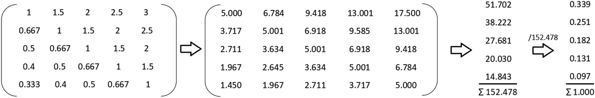
Matrix 1 and matrix 2.
In order to determine the validity of the matrix, the following parameter values are included:
where λmax is the maximum eigenvalue of the matrix; CI is the consistency index and CR is the consistency ratio.
Fires have the highest frequency of all natural disasters in Štrpce, which is the main reason why they were assigned the greatest weighting factor (0.339). During the summer months, tens to hundreds of hectares of land are affected by forest fires, mostly caused by human negligence. Earthquakes are rare in the municipality of Štrpce but this area is prone to intensive seismic activity of a magnitude up to VIII MCS. Therefore, this disaster was assigned a weighting factor of 0.251. The last major earthquake (VIII MCS) was recorded 99 years ago. Although there is potential, greater torrents in the municipality of Štrpce have not been recorded in the last 40 years, and therefore, were assigned a coefficient of 0.182. Avalanches represent a great threat to tourists and buildings located at high altitudes on Šar Mountain and hence avalanches were assigned a coefficient of 0.131. Soil erosion is an important factor for the entire analysis of natural disasters in this area; for the municipality of Štrpce, the weight coefficient for erosion is 0.097. In addition, a high degree of erosion carries away large amounts of soil and increases water retention on surfaces [77,78].
Intensive washing away and removal of particles from the loose substrate would significantly reduce agricultural productivity, which is at a satisfactory level in this municipality. Based on the obtained weight coefficients, total susceptibility to natural disasters was processed. Classes of each criterion are multiplied by weighting coefficients, and then their results are added up:
where F represents forest fires, Z the seismic hazard, T the torrential floods, A the snow avalanches, and E the erosion. After summarizing the research results, they were classified into four risk classes: low, medium, high, and very high.
All procedures and approaches used for the purpose of this research are presented in the flow chart given in Figure 3.
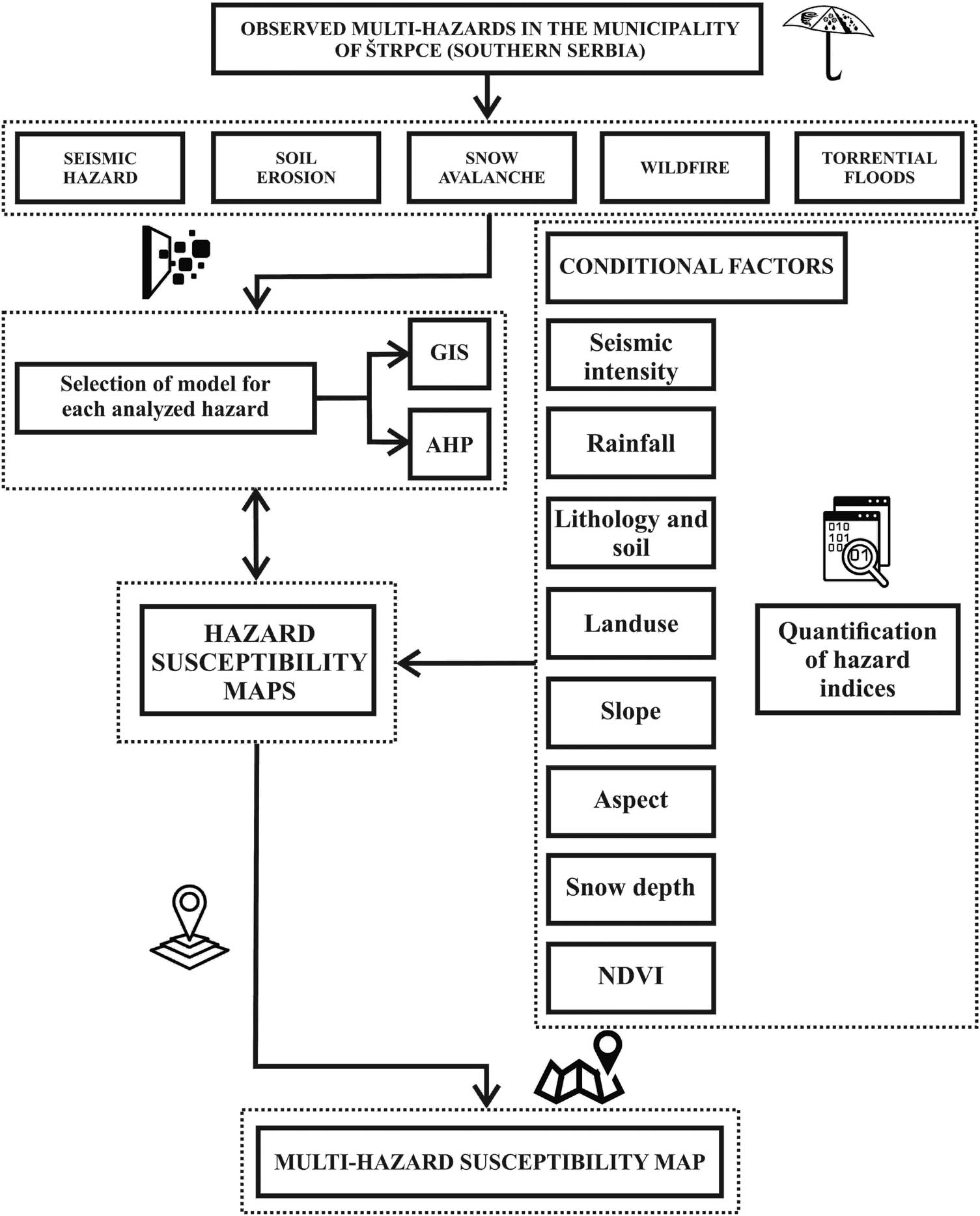
Flow chart of procedures used in this research.
4 Results
4.1 Seismic hazard analysis
According to the obtained data, an area of 141.47 km2 (60.8% share in the territory) has a potential intensity MCS of 7–8, while at 91.07 km2 (39.2% share in the territory), the estimated seismic hazard has a magnitude of 8 MCS.
Occurrences of autochthonous earthquakes have been registered in the northwestern, central, and southeastern part of the municipality, VII–VIII MCS, indicating that great attention regarding seismic hazards should be paid to the territories outside the municipality [34]. Based on a seismic hazard, the magnitude of potentially strongest earthquakes for the following 475 years would be VII–VIII and VIII MCS (Figure 4).
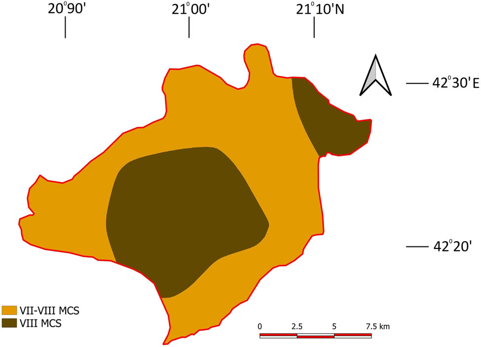
Seismic hazard for a 475 year return period.
4.2 Erosion intensity
An erosion intensity map for the municipality of Štrpce was obtained by using the EPM model, as well as by analyzing and processing a terrain slope, land use type, BSI, and pedological cover. The average erosion coefficient is 0.34 (Figure 5).
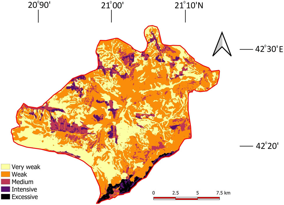
Erosion intensity map.
The erosion intensity situation in Štrpce is generally satisfactory. Most of the municipality (50.03%) is characterized by weak erosion. One-third of the municipality is affected by a very weak erosion (Table 10).
Types of erosion intensities
| Type of erosion | Area (km2) | Share in the territory (%) |
|---|---|---|
| Very weak | 78.40 | 33.67 |
| Weak | 116.50 | 50.03 |
| Medium | 24.47 | 10.51 |
| Intensive | 9.12 | 3.92 |
| Excessive | 4.38 | 1.88 |
| Total | 232.87 | 100.00 |
Excessive erosion occurs in the southern part of the municipality, on the slopes of Šar Mountain with sparse vegetation, pronounced terrain slope, and a large amount of precipitation.
In this area, it is necessary to consider the entire erosion situation on the ground, as well as to take appropriate anti-erosion measures in order to reduce the erosion intensity and therefore soil loss. The total sediment production in the municipality is 131.795 m3/year, while the specific sediment production is 565.96 m3/km2/year.
4.3 Susceptibility to torrential floods
By processing and analyzing the main characteristics of the terrain slope, land types, land use, and BSI, a map of the terrain’s susceptibility to torrential floods was obtained (Figure 6).

Map of terrain susceptibility to torrential floods.
A large part of the municipality of Štrpce has a high (43.33%) and very high (18.86%) susceptibility to the occurrence of torrential floods (Table 11). Low and medium susceptibility is mainly present in central (the Lepenac valley) and southwestern parts of the municipality. Areas most prone to torrents are characterized by a great terrain slope, absence of forests, and bare and loose soil.
Terrain susceptibility to torrential floods
| Susceptibility to torrents | Area (km2) | Share in the territory (%) |
|---|---|---|
| Low | 19.02 | 8.17 |
| Medium | 69.03 | 29.64 |
| High | 100.91 | 43.33 |
| Very high | 43.91 | 18.86 |
| Total | 232.87 | 100.00 |
Due to large amounts of precipitation in a short period of time, the rivers flowing through such terrain can be extremely dangerous for the population and the environment (Figures 7 and 8).
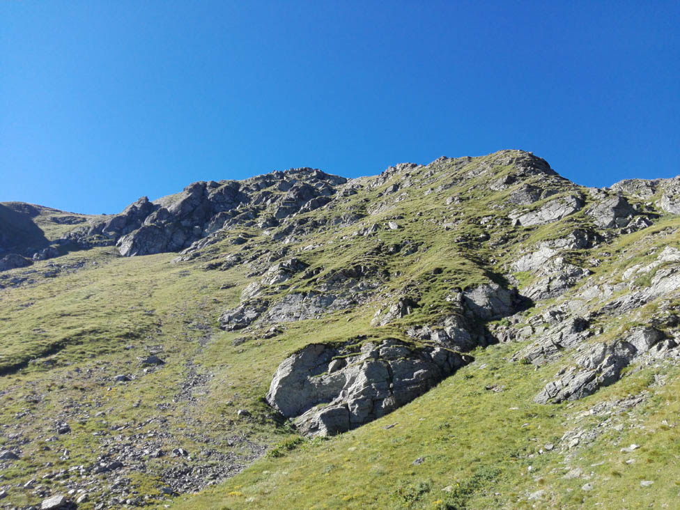
Photographs from the field indicating susceptible areas due to great terrain slope, absence of forests, and presence of bare and loose soil (Photo: U. Durlević).
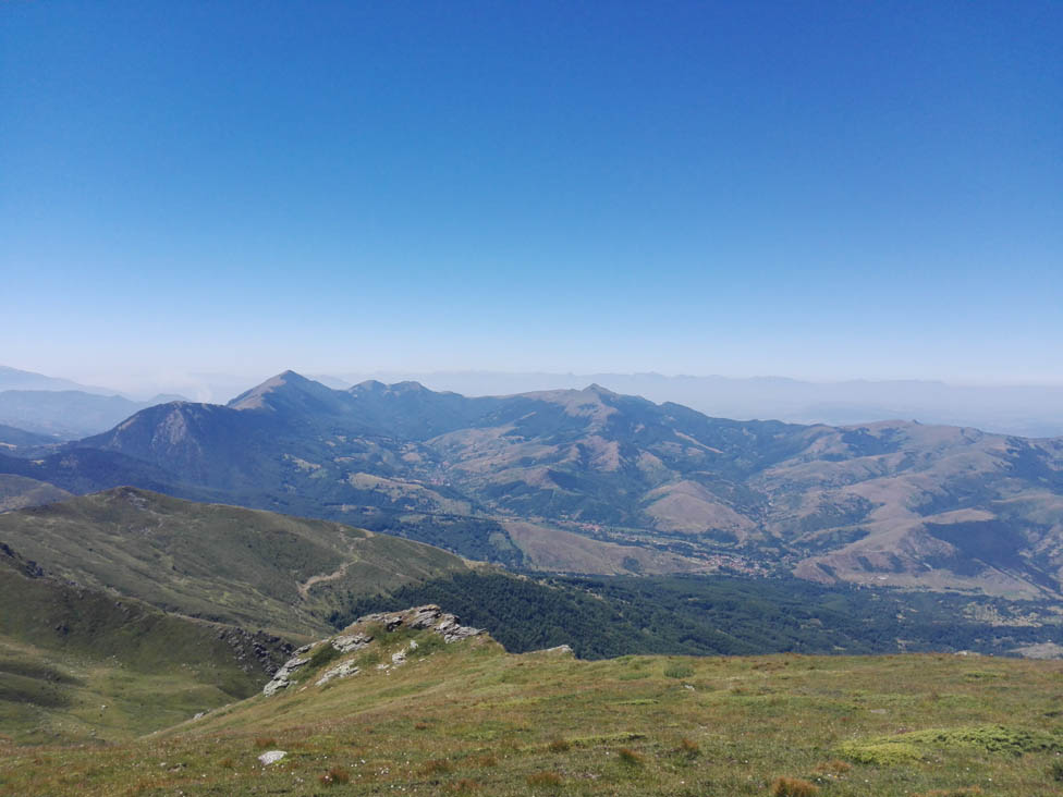
Photographs from the field indicating areas most prone to torrents (Photo: U. Durlević).
It is necessary to determine and implement concrete protective measures against torrential floods through the combination of GIS software packages and field research in order to prevent their harmful effects. Local self-government units, in cooperation with provincial and state services, can provide funds for the implementation of biological and biotechnical measures that would significantly reduce high and very high torrential flood risk in a terrain.
4.4 Susceptibility to snow avalanches
By processing the available data in GIS software packages, a map of terrain susceptibility to avalanches was obtained (Figure 9). On a 9.1 km2 of the municipality area, there are favorable conditions for the formation of avalanches, while chances for avalanches in other parts of the municipality are very small.
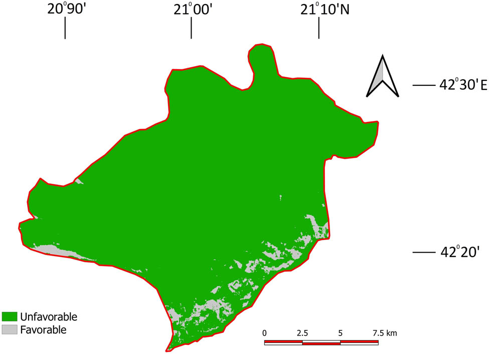
Map of susceptibility to snow avalanches.
Susceptibility to avalanches occurs in southern and western parts of the municipality, on the slopes of Šar Mountain, on Ošljak ridge, Čerenački peak, and Ostrvica peak. Field research is needed in order to confirm the obtained results of the conducted office work and to prohibit any anthropogenic activity during the winter and spring period in avalanche-prone terrain. To prevent or mitigate the effects of avalanches, it is possible to afforest terrains at risk with species represented at high altitudes (Heldreich’s pine and Balkan pine), in order to prevent the accumulation of large snow masses. Another method is to build special fences that restrict the movement of snow deposits.
4.5 Susceptibility to forest fires
Based on the analysis and processing of existing data in GISs, the susceptibility map of forest fires of the municipality of Štrpce was obtained. Susceptibility was divided into four classes: low, medium, high, and very high (Figure 10).
Map of terrain susceptibility to forest fires.
Due to a significant area under the forest cover (117.72 km2) and a relatively great terrain slope, the municipality generally has high susceptibility to forest fires (Table 12). Terrains with a large slope and southern exposure are the ones that are most vulnerable to forest fires. These are mostly coniferous or mixed forests that are relatively close to roads and settlements.
Terrain susceptibility to forest fires
| Susceptibility to forest fires | Area (km2) | Share in the territory (%) |
|---|---|---|
| Low | 13.49 | 5.79 |
| Medium | 77.67 | 33.35 |
| High | 122.01 | 52.40 |
| Very high | 19.79 | 8.50 |
| Total | 232.86 | 100.00 |
More than half of the municipality area is highly susceptible to forest fires, while the area of almost 20 km2 has a very high susceptibility. Medium susceptibility occurs in one-third of the territory, while low susceptibility is represented in 5.79% of the municipality.
4.6 Modeling the total susceptibility to natural hazards
Obtained results are of great importance for the local community and all institutions dealing with environmental protection and emergency management because they provide an overview of potentially most endangered locations in this area.
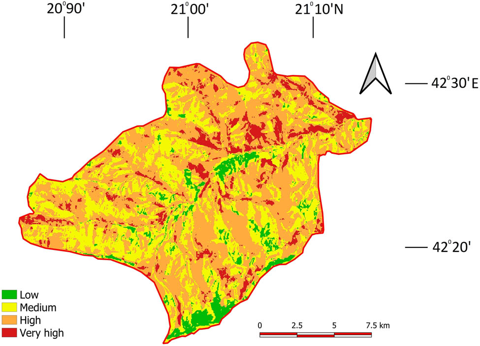
When considering the total susceptibility to natural disasters (Figure 11), the municipality is dominated by a medium and high susceptibility, found on 93% of the municipality.
Map of the total susceptibility to natural hazards.
Low susceptibility (5.23%) most often occurs in the central part of the municipality, while very high susceptibility occurs in central, southern, and eastern parts of the municipality, with a total share of 1.71% (Table 13).
Classes of total susceptibility to natural hazards
| Susceptibility | Area (km2) | Share in the territory (%) |
|---|---|---|
| Low | 12.12 | 5.23 |
| Medium | 115.12 | 49.66 |
| High | 100.60 | 43.40 |
| Very high | 3.97 | 1.71 |
| Total | 231.80 | 100.00 |
For more efficient environmental management, it is necessary to identify areas within all settlements that have a high and very high susceptibility to natural disasters and to implement concrete protective measures that would reduce the possibility of occurrence of all analyzed disasters.
5 Discussion
5.1 Seismic hazard
The area of Šar Mountain is an extremely seismically active area in Serbia. The municipality of Štrpce is not endangered by stronger autochthonous earthquakes but it is occasionally exposed to a seismic action with epicenters at greater or lesser distances. Contemporary earthquake data indicate that the occurrence of catastrophic earthquakes was registered in 1457 when an IX MCS earthquake hit the region near Prizren. A strong earthquake occurred in 1921 in the Uroševac-Vitina direction; in the municipality of Štrpce, it was registered with an intensity of VIII MCS. In the municipality of Štrpce, a seismic hazard was identified for a 475 years return period, relying on the official maps of the Seismological Survey of Serbia. The obtained results (VII–VIII MCS and VIII MCS) indicate that it is necessary to observe the modern seismic design standards to avoid or mitigate significant human and material losses.
5.2 Soil erosion
The main consequence of soil degradation is represented in the form of a significant reduction of soil productivity, which directly affects those whose employment depends on this natural resource [79].
In order to improve soil erosion management and help decision-makers in adopting appropriate remediation measures and mitigation strategies, the first step is to monitor and assess the system to obtain adequate and reliable information on soil erosion in the current climate and land use conditions [48,80]. In the southern, northern, and central territories of the municipality of Štrpce, 16.31% of the area is affected by medium, intensive or excessive erosion. Therefore, it is necessary to implement adequate agrotechnical measures on agricultural plots affected by stronger erosion and assess whether soil quality is suitable to pursue agricultural activities. For other territories not cultivated by man, it is also necessary to determine biological and technical measures to mitigate erosion effects (afforestation, grassing over).
5.3 Torrential floods
The emergence of natural and anthropogenic extremes around the world leads us to pay more attention to their impacts on the environment and the economy [81,82]. In all their various forms, floods are the most common type of natural disasters that are occurring worldwide [83,84]. Among the natural hazards with the highest risk for people and their activities, torrential floods are considered as the most common danger in Serbia [20,85] as well as the most significant in terms of great material damage and loss for humans lives. The frequency of these events, their intensity, and representation throughout the country make them a constant threat with serious consequences for the environment, economic, and social sphere [20]. In Serbia, more than 12,000 watercourses have been identified as having a torrential character [38]. Identifying locations that are the most susceptible to torrents is of great importance, as the largest part of arable land is located near rivers.
Due to the great ecological significance of this study area, it is necessary to continuously monitor the state of the environment. Large amounts of precipitation in a short period of time and a pronounced terrain slope are the main causes of the occurrence of torrential floods. In the last 100 years, great torrential floods have been recorded in 1953 and 1979, when the Lepenac River destroyed houses and bridges in the municipality. As with soil erosion, areas susceptible to torrential floods (very high and high susceptibility) need to be subjected to biotechnical and biological measures aimed at environmental protection.
5.4 Snow avalanches
Snow avalanches are one of the biggest threats for people, buildings, and roads and they are greatly affecting mountain ecosystems [86]. Snow avalanches that contain rocks, soil, broken trees, or ice, apart from snow, are characterized by short, local, dynamic occurrences in many mountainous areas [87].
The territory of the municipality is predisposed to the occurrence of snow avalanches if it is located on a suitable slope of terrain (20–60°), where a large amount of snowfall and the absence of woody vegetation (high mountain meadows and pastures) are recorded.
Terrains susceptible to avalanches are characterized by a high slope, north-facing aspects, a low degree of surface roughness, deep snow cover, and sparse vegetation. Such territories can be dangerous for tourists and infrastructure within the Brezovica Ski Center. Therefore, it is necessary to implement avalanche protective measures, i.e., to afforest the terrain with particular species to maintain and increase snow load stability.
5.5 Fire hazards
Forest fires are one of the most common natural disasters. Apart from weather conditions, there are many other factors that influence the occurrence of forest fires [88]. Due to the increase in global temperature on the Earth, but also due to expressed human negligence, enormous areas are affected by fire each year, both in Serbia and in the world. In 97% of cases, forest fires are caused by humans; however, natural conditions determine a predisposition of territory for fires, and therefore, the analysis of natural conditions is the key for determining the level of endangerment of the concrete area [54]. The Republic of Serbia is covered by approximately 31.1% (27.480 km2) of the forest, The fires in the period 1990–2005 destroyed 43,000 ha of forest cover in Serbia [89].
Some settlements of the municipality of Štrpce are highly or extremely prone to fires. In addition to the impact on the population, fires have a significant negative impact on flora and fauna, which is exceptionally diverse in this part of Serbia. Therefore, satellite monitoring [90] of vegetation conditions and installing sensors in endangered areas would facilitate environmental management in this part of the Šar Mountain National Park.
5.6 Total susceptibility to natural hazards
Total susceptibility to natural hazards can provide a good overview of vulnerable zones aimed at protecting the environment, and natural and cultural heritage [69,91,92]. Based on the field experience, the weighting coefficients for each geohazard have been determined using the AHP method. Due to the highest frequency of forest fires, this hazard has been assigned the highest weighting coefficient. It is followed by seismic hazards, torrential floods, avalanches, and soil erosion. Processing the five criteria in GIS software gives the results of the total terrain’s susceptibility to geohazards.
More than 45% of the municipality of Štrpce territory has been identified as susceptible or very susceptible to natural hazards. A large number of settlements belong to one of these two classes: Sušiće, Koštanjevo, Ižance, Viča, Gotovuša, Vrbeštica, Donja Bitinja, Berevce, Sevce, and Brezovica Ski Center. In these places, it is first necessary to consider individually which natural hazard is the most dominant in order to implement adequate preventive measures.
6 Conclusion
Vulnerability analysis of the territories that are most sensitive to natural hazards will enable more adequate and efficient adoption of preventive measures and more correct environmental management actions by local, provincial, and state services. Due to its morphometric characteristics, geographical position, the richness of biodiversity and geodiversity, the municipality of Štrpce is an ideal territory for the analysis of natural hazards. In GISs, by using the relevant data for the entire researched area, the terrain was analyzed for susceptibility to forest fires, earthquakes, torrents, avalanches, and erosion. Forest fires are identified as the most common natural disaster in the municipality. More than 60% of the municipality area is susceptible or very susceptible to forest fires. As for earthquakes, Šar Mountain foothills are seismically very active, so larger magnitude earthquakes (VII–VIII MCS) might occur on the territory of Štrpce or in the surrounding municipalities. Assessing the seismicity of existing buildings and observing standards when constructing future buildings would significantly contribute to protecting the population from potential earthquakes.
Torrential floods have not been a problem in the municipality of Štrpce for the past 40 years, but nowadays more than half of the municipality’s area is highly and very highly susceptible to torrential floods. More than 18% of the territory is very susceptible to torrential floods. During the winter and spring, snow avalanches could cause great damage in the form of casualties, damage to buildings, and natural devastation. The terrain area prone to avalanches is 9.1 km2 and covers the area of the highest parts of Šar Mountain, Ošljak, Ostrvica, and Čerenački peak.
In the researched area, it was determined that the mean erosion coefficient is 0.34, which corresponds to the category of weak erosion. In addition to the increase in the erosion coefficient, only 5.8% of the municipality area is affected by strong and excessive erosion. By analyzing five disasters and by using the methods such as GIS and AHP, a map of the total terrain susceptibility to natural disasters was obtained, on which almost 105 km2 of the municipality area is highly or very highly susceptible. In this area, which is a part of the Šar Mountain National Park, it is necessary to combine the obtained results with field research in order to greatly preserve and improve the geodiversity and biodiversity of the area. Public companies dealing with nature protection, in cooperation with provincial and state environmental institutions and local environmental movements could take measures to protect and improve the territory by monitoring and auditing environmental elements in order to mitigate the risk of natural disasters in the municipality of Štrpce. Furthermore, standardization and implementation of the multihazard methodologies would be an important step toward more qualitative monitoring and identification of natural disasters at a local and regional scale in the Republic of Serbia. Such an approach would highlight the importance of the risk assessment and management programs, which are currently being developed in this part of Southeast Europe.
In the end, this research could be further extended by a larger investigation. This investigation may cover the entire territory of the Republic of Serbia. The maps and calculations from this research may serve as the basis of a potential project of hazardous events. Šar Mountain presents an area not investigated enough, with specific and very rare nature in this part of the Balkan Peninsula. After this research, we can find better ways for protecting this specific area. Environmental devastation in the future may be prevented by means of precise numerical and GIS analysis. Thus, the lives of people and properties may be saved and protected.
Acknowledgements
The authors are grateful to the anonymous reviewers whose comments and suggestions greatly improved the manuscript. Dr. Tin Lukić acknowledges partial support of the H2020 WIDESPREAD-05-2020 – Twinning: ExtremeClimTwin under grant agreement No. 952384.
-
Author contributions: U.D.: conceptualization; I.N. and A.V.: writing-original draft preparation; T.L. and N.B.: writing-review and editing; I.S.: visualization; F.K.: graphically presentation of the data; M.M.: analysis of data; V.Ć.: preprocessing of data in the GIS.
-
Conflict of interest: Authors state no conflict of interest.
References
[1] Lukić T, Bjelajac D, Fitzsimmons KE, Marković SB, Basarin B, Mlađan D, et al. Factors triggering landslide occurrence on the Zemun loess plateau, Belgrade area, Serbia. Environ Earth Sci. 2018;77:519.10.1007/s12665-018-7712-zSuche in Google Scholar
[2] Kovačević-Majkić J, Panić M, Miljanović D, Miletić R. Vulnerability to natural disasters in Serbia: spatial and temporal comparison. Nat Hazards. 2014;72:945–68.10.1007/s11069-014-1045-3Suche in Google Scholar
[3] Keller EA, De Vecchio DE. Natural hazards: Earth’s processes as hazards, disasters, and catastrophes. Abingdon, UK: Routledge; 2016.10.4324/9781315269160Suche in Google Scholar
[4] Blaikie P, Cannon T, Davis I, Wisner B. At risk: natural hazards, people’s vulnerability and disasters. Abingdon, UK: Routledge; 2014.10.4324/9780203714775Suche in Google Scholar
[5] Vasculisteanu G, Niculita M, Margarint MC. Natural hazards and their impact on rural settlements in NE Romania – A cartographical approach. Open Geosci. 2019;11:765–82.10.1515/geo-2019-0060Suche in Google Scholar
[6] Valjarević A, Djekić T, Stevanović V, Ivanović R, Jandziković B. GIS numerical and remote sensing analyses of forest changes in the Toplica region for the period of 1953–2013. Appl Geo. 2018;92:131–9.10.1016/j.apgeog.2018.01.016Suche in Google Scholar
[7] Novković I, Dragićević S, Živković N, Tošić R, Čvorović Z. Vulnerability assessment of the Jošanička River Basin to torrential floods and forest fires. Advances in GeoEcology, vol. 45 – Soil and water resources protection in the changing environment. Catena: Schweizerbart Science Publishers; 2018. p. 48–65Suche in Google Scholar
[8] Valjarević A, Radovanović D, Šoškić S, Bačević N, Milentijević N, Golijanin J, et al. GIS and geographical analysis of the main harbors in the world. Open Geosci. 2021;13:639–50.10.1515/geo-2020-0223Suche in Google Scholar
[9] Bathrellos GD, Skilodimou HD, Chousianitis K, Youssef AM, Pradhan B. Suitability estimation for urban development using multi-hazard assessment map. Sci Total Env. 2017;575:119–34.10.1016/j.scitotenv.2016.10.025Suche in Google Scholar PubMed
[10] Skilodimou HD, Bathrellos GD, Chousianitis K, Youssef AM, Pradhan B. Multi-hazard assessment modeling via multi-criteria analysis and GIS: A case study. Env Earth Sci. 2019;78(2):47.10.1007/s12665-018-8003-4Suche in Google Scholar
[11] Sevieri G, Galasso C, D’Ayala D, De Jesus R, Oreta A, Grio AMED, et al. A multi-hazard risk prioritisation framework for cultural heritage assets. Nat Hazards Earth Syst Sci. 2020;20:1391–414.10.5194/nhess-20-1391-2020Suche in Google Scholar
[12] Lombardo L, Tanyas H, Nicu CI. Spatial modeling of multi-hazard threat to cultural heritage sites. Eng Geol. 2020;277:105776.10.1016/j.enggeo.2020.105776Suche in Google Scholar
[13] Pourghasemi RH, Kariminejad N, Amiri M, Edalat M, Zarafshar M, Blaschke T, et al. Assessing and mapping multihazard risk susceptibility using a machine learning technique. Sci Rep. 2020;10:3203.10.1038/s41598-020-60191-3Suche in Google Scholar
[14] Javidan N, Kavian A, Pourghasemi RH, Conoscenti C, Jafarian Z, Rodrigo-Comino J. Evaluation of multi-hazard map produced using MaxEnt machine learning technique. Sci Rep. 2021;11:6496.10.1038/s41598-021-85862-7Suche in Google Scholar
[15] Borges RG, de Assumpção MS, de Almeida MCF, de Almeida M. Seismicity and seismic hazard in the continental margin of southeastern Brazil. J Seism. 2020;24:1205–24.10.1007/s10950-020-09941-4Suche in Google Scholar
[16] Anderson GJ. Benefits of scenario ground motion maps. Eng Geol. 1997;48(1–2):43–57.10.1016/S0013-7952(97)81913-8Suche in Google Scholar
[17] Krinitzsky EL. How to obtain earthquake ground motions for engineering design. Eng Geol. 2002;65(1):1–16.10.1016/S0013-7952(01)00098-9Suche in Google Scholar
[18] Lazarević R. The erosion map of Serbia (1:500 000). Belgrade, Serbia: Institute of Forestry; 1983. (In Serbian).Suche in Google Scholar
[19] Dragićević S, Filipović D, Kostadinov S, Ristić R, Novković I, Živković N, et al. Natural hazard assessment for land-use planning in Serbia. Int J Env Res. 2011;5(2):71–380.Suche in Google Scholar
[20] Ristić R, Kostadinov S, Abolmasov B, Dragićević S, Trivan G, Radić B, et al. Torrential floods and town and country planning in Serbia. Nat Hazards Earth Syst Sci. 2012;12:23–35.10.5194/nhess-12-23-2012Suche in Google Scholar
[21] Kostadinov S, Dragićević S, Stefanović T, Novković I, Petrović A. Torrential flood prevention in the Kolubara River Basin. J Mt Sci. 2017;14(11):2230–45.10.1007/s11629-017-4575-9Suche in Google Scholar
[22] Ristanović B, Cimbaljević M, Miljković Đ, Ostojić M, Fekete R. GIS application for determining geographical factors on intensity of erosion in Serbian river basins. Case study: The river basin of Likodra. Atmosphere. 2019;10:526.10.3390/atmos10090526Suche in Google Scholar
[23] Ighodaro ID, Lategan FS, Yusuf SGF. The impact of soil erosion on agricultural potential and performance of Sheshegu community farmers in the eastern cape of South Africa. J Agric Sci. 2013;5(5):140–47.10.5539/jas.v5n5p140Suche in Google Scholar
[24] Souza FG, Melo VF, Araújo WF, Araújo HTC. Losses of soil, water, organic carbon and nutrients caused by water erosion in different crops and natural savannah in the northern Amazon. Ambiente Água – An Interdiscip J Appl Sci. 2018;40(1):1–5.10.4136/ambi-agua.2126Suche in Google Scholar
[25] Durlević U, Momčilović A, Ćurić V, Dragojević M. Gis application in analysis of erosion intensity in the Vlasina river basin. Bull Serbian Geograph Soc. 2019;99(2):17–36.10.2298/GSGD1902017DSuche in Google Scholar
[26] Stefanidis PS, Chatzichristaki AC, Stefanidis SP. An ArcGIS toolbox for estimation and mapping soil erosion. J Environ Prot Ecol. 2021;22(2):689–96.Suche in Google Scholar
[27] Schmidt-Thome P, Greiving S, Kallio H, Fleischhauer M, Jarva J. Economic risk maps of floods and earthquakes for European regions. Quater Intern. 2006;150(1):103–12.10.1016/j.quaint.2006.01.024Suche in Google Scholar
[28] Toya H, Skidmore M. Economic development and the impacts of natural disasters. Econ Lett. 2007;94(1):20–5.10.1016/j.econlet.2006.06.020Suche in Google Scholar
[29] Lukić T, Dunjić J, Đerčan B, Penjišević I, Milosavljević S, Bubalo-Živković M, et al. Local resilience to natural hazards in Serbia. Case study: The West Morava river valley. Sustainability. 2018;10(2866):1–16.10.3390/su10082866Suche in Google Scholar
[30] Blöschl G, Hall J, Viglione A, Perdigão RAP, Parajka J, Merz B, et al. Changing climate both increases and decreases European river floods. Nature. 2019;573:108–11.10.1038/s41586-019-1495-6Suche in Google Scholar PubMed
[31] Tilloy A, Malamud DB, Winter H, Joly-Laugel A. A review of quantification methodologies for multi-hazard interrelationships. Earth-Sci Rev. 2019;196:102881.10.1016/j.earscirev.2019.102881Suche in Google Scholar
[32] Nachappa GT, Ghorbanzadeh O, Gholamnia K, Blaschke T. Multi‐hazard exposure mapping using machine learning for the state of Salzburg, Austria. Remote Sens. 2020;12:2757.10.3390/rs12172757Suche in Google Scholar
[33] Shahabi H, Shirzadi A, Ghaderi K, Omidvar E, Al-Ansari N, Clague JJ, et al. Flood detection and susceptibility mapping using Sentinel-1 remote sensing data and a machine learning approach: hybrid intelligence of bagging ensemble based on K-Nearest neighbor classifier. Remote Sens. 2020;12:266.10.3390/rs12020266Suche in Google Scholar
[34] Dinić J. Commune Štrpce, Sirinićka župa. Trait of natural environment. Belgrade: Geographical institute “Jovan Cvijić” SASA; 1990.Suche in Google Scholar
[35] Elhag M, Boteva S, Al-Amri N. Forest cover assessment using remote-sensing techniques in Crete Island, Greece. Open Geosci. 2021;13:345–58.10.1515/geo-2020-0235Suche in Google Scholar
[36] Valjarević A, Srećković-Batoćanin D, Valjarević D, Matović VA. GIS-based method for analysis of a better utilization of thermal-mineral springs in the municipality of Kursumlija (Serbia). Renew sustain. Energy Rev. 2018;92:948–57.10.1016/j.rser.2018.05.005Suche in Google Scholar
[37] Durlević U. Assessment of torrential flood and landslide susceptibility of terrain: Case study – Mlava river basin. Bull Serbian Geograph Soc. 2021;101(1):49–75.10.2298/GSGD2101049DSuche in Google Scholar
[38] Petrović MA, Novković I, Kostadinov S. Hydrological analysis of the September 2014 torrential floods of the Danube tributaries in the Eastern Serbia. Nat Haz. 2021;108:1373–87.10.1007/s11069-021-04737-2Suche in Google Scholar
[39] Tran P, Shaw R, Chantry G, Norton J. GIS and local knowledge in disaster management: a case study of flood risk mapping in Viet Nam. Disasters. 2009;33:152–69.10.1111/j.1467-7717.2008.01067.xSuche in Google Scholar PubMed
[40] Frigerio I, Ventura S, Strigaro D, Mattavelli M, De Amicis M, Mugnano S, et al. A GIS-based approach to identify the spatial variability of social vulnerability to seismic hazard in Italy. Appl Geo. 2016;74:12–22.10.1016/j.apgeog.2016.06.014Suche in Google Scholar
[41] Hassanzadeh R, Nedović-Budić Z, Razavi AA, Norouzzadeh M, Hodhodkian H. Interactive approach for GIS-based earthquake scenario development and resource estimation (Karmania hazard model). Comput Geosci. 2013;51:324–38.10.1016/j.cageo.2012.08.016Suche in Google Scholar
[42] Menković Lj, Milivojević M. Glacial morphology of the Šara mountains. Bull Serbian Geograph Soc. 2021;101(1):1–29.10.2298/GSGD2101001MSuche in Google Scholar
[43] Gavrilovic S. Engineering of torrents and erosion. J Constr. (Special Issue). 1972;1–292, (In Serbian).Suche in Google Scholar
[44] De Vente J, Poesen J, Verstraeten G. The application of semiquantitative methods and reservoir sedimentation rates for the prediction of basin sediment yield in Spain. J Hydro. 2005;305(1–4):63–86.10.1016/j.jhydrol.2004.08.030Suche in Google Scholar
[45] Manojlovic S, Antic M, Sibinovic M, Dragicevic S, Novkovic I. Soil erosion response to demographic and land use changes in the Nišava River basin, Serbia. Fresenius Environ Bull. 2017;26(12):7547–60.Suche in Google Scholar
[46] Živković N. Average annual and seasonal river runoff in Serbia. Belgrade: University of Belgrade, Faculty of Geography; 2009. (In Serbian).Suche in Google Scholar
[47] Mutekanga FP, Visser SM, Stroosnijder L. A tool for rapid assessment of erosion risk to support decision-making and policy development at the Ngenge watershed in Uganda. Geoderma. 2010;160:165–74.10.1016/j.geoderma.2010.09.011Suche in Google Scholar
[48] Kumar N, Singh SK, Pandey HK. Drainage morphometric analysis using open access earth observation datasets in a drought-affected part of Bundelkhand, India. Appl Geomat. 2018;10:173–89.10.1007/s12518-018-0218-2Suche in Google Scholar
[49] Maliqi E, Singh SK. Quantitative estimation of soil erosion using open-access earth observation data sets and erosion potential model. Water Conserv Sci Eng. 2019;4:187–200.10.1007/s41101-019-00078-1Suche in Google Scholar
[50] Langović M, Dragićević S, Novković I, Živković N, Tošić R, Milojković B, et al. Assessment of the soil loss caused by riverbank erosion in Serbia. Bull Serbian Geographical Soc. 2021;101(1):31–47.10.2298/GSGD2101031LSuche in Google Scholar
[51] Kumar N, Singh SK. Soil erosion assessment using earth observation data in a trans‑boundary river basin. Nat Haz. 2021;107:1–34.10.1007/s11069-021-04571-6Suche in Google Scholar
[52] Diek S, Fornallaz F, Schaepman M, De Jong R. Barest pixel composite for agricultural areas using landsat time series. Remote Sens. 2017;9:1245.10.3390/rs9121245Suche in Google Scholar
[53] https://www.eea.europa.eu/data-and-maps/data/eu-dem (accessed on 22.02.2021).Suche in Google Scholar
[54] Novković DI. Natural conditions as determinants of geohazards on the example of Ljig, Jošanička and Vranjskobanjska River Basins. PhD thesis. Belgrade: University of Belgrade; 2016. Faculty of Geography (In Serbian with English summary).Suche in Google Scholar
[55] Minea G. Assessment of the flash flood potential of Bâsca river catchment (Romania) based on physiographic factors. Cent Eur J Geosci. 2013;5(3):344–53.10.2478/s13533-012-0137-4Suche in Google Scholar
[56] Costache R, Pravalie R, Mitof I, Popescu C. Flood vulnerability assessment in the low sector of Saratel Catchment. Case study: Joseni village. Carpathian J Earth Env Sci. 2015;10(1):161–9.Suche in Google Scholar
[57] Tincu R, Lazar G, Lazar I. Modified flash flood potential index in order to estimate areas with predisposition to water accumulation. Open Geosci. 2018;10:593–606.10.1515/geo-2018-0047Suche in Google Scholar
[58] Smith G. Flash flood potential: Determining the hydrologic response of FFMP basins to heavy rain by analyzing their physiographic characteristics. Salt Lake City: NWS Colorado Basin River Forecast Center; 2003.Suche in Google Scholar
[59] Ristić R, Radić B, Vasiljević N. Characteristics of maximal discharges on torrential watersheds in Serbia. Bull Serbian Geograph Soc. 2009;89(4):161–89.10.2298/GSGD0904161RSuche in Google Scholar
[60] Prăvălie R, Costache R. The analysis of the susceptibility of the flash-floodsʼ genesis in the area of the hydrographical basin of Bâsca Chiojdului river. Forum Geografic. 2014;13(1):39–49.10.5775/fg.2067-4635.2014.071.iSuche in Google Scholar
[61] Minea G, Iliescu M, Dedu F. Temporal rainfall properties at events scale in the Curvature Subcarpathians (Romania). Forum Geografic. 2016;15:115–23.10.5775/fg.2016.141.sSuche in Google Scholar
[62] Kostadinov S, Braunović S, Dragićević S, Zlatić M, Dragović N, Rakonjac N. Effects of erosion control works: case study – Grdelica Gorge, the South Morava River (Serbia). Water. 2018;10:1–18.10.3390/w10081094Suche in Google Scholar
[63] Maggioni M, Gruber U. The influence of topographic parameters on avalanche release dimension and frequency. Avalanche dynamics. Int Snow Sci Work. 2002;97–104.Suche in Google Scholar
[64] Pistocchi A, Notarnicola C. Data-driven mapping of avalanche release areas: a case study in South Tyrol, Italy. Nat Haz. 2012;65:1313–30.10.1007/s11069-012-0410-3Suche in Google Scholar
[65] Bühler Y, Von Rickenbach D, Stoffel A, Margreth S, Stoffel L, Christen M. Automated snow avalanche release area delineation – validation of existing algorithms and proposition of a new object-based approach for large-scale hazard indication mapping. Nat Hazards Earth Syst Sci. 2018;18:3235–51.10.5194/nhess-18-3235-2018Suche in Google Scholar
[66] McClung DM, Schaerer P. The avalanche handbook. Seattle: The Mountaineers Books; 2006.Suche in Google Scholar
[67] Rouse WJ, Haas HR, Schell AJ, Deering WD. Monitoring vegetation systems in the Great Plains with ERTS. Proceedings of 3rd Earth Resources Technology Satellite-1 Symposium. Washington, DC; 1973.Suche in Google Scholar
[68] Tucker CJ. Red and photographic infrared linear combinations for monitoring vegetation. Remote Sens Env. 1979;8(2):127–50.10.1016/0034-4257(79)90013-0Suche in Google Scholar
[69] Zhan Y, Fan J, Meng T, Li Z, Yan Y, Huang J, et al. Analysis on vegetation cover changes and the driving factors in the mid-lower reaches of Hanjiang River Basin between 2001 and 2015. Open Geosci. 2021;13:675–89.10.1515/geo-2020-0259Suche in Google Scholar
[70] Erten E, Kurgun V, Musaoglu N. Forest fire risk zone mapping from satellite imagery and GIS – a case study. XXth Congress of the International Society for Photogrammetry and Remote Sensing. Turkey, Istanbul: 2004.Suche in Google Scholar
[71] Atanasova–Pachemska T, Lapevski M, Timovski R. Analytical hierarchical process (AHP) method application in the process of selection and evaluation. International Scientific Conference “UNITECH 2014”. Gabrovo; 2014.Suche in Google Scholar
[72] Maceika A, Bugajev A, Šostak OR, Vilutienė T. Decision tree and AHP methods application for projects assessment: a case study. Sustainability. 2021;13:5502.10.3390/su13105502Suche in Google Scholar
[73] Bathrellos GD, Gaki-Papanastassiou K, Skilodimou HD, Skianis GA, Chousianitis KG. Assessment of rural community and agricultural development using geomorphological-geological factors and GIS in the Trikala prefecture (Central Greece). Stoch Env Res Risk Assess. 2013;27:573–88.10.1007/s00477-012-0602-0Suche in Google Scholar
[74] Bathrellos GD, Karymbalis E, Skilodimou HD, Gaki-Papanastassiou K, Baltas EA. Urban flood hazard assessment in the basin of Athens Metropolitan city, Greece. Env Earth Sci. 2016;75:319.10.1007/s12665-015-5157-1Suche in Google Scholar
[75] Saaty TL. Analytic hierarchy process. New York: McGraw-Hill; 1980.Suche in Google Scholar
[76] Saaty TL. How to make a decision: the analytic hierarchy process. Eur J Operational Res. 1990;48:9–26.10.13033/isahp.y1988.042Suche in Google Scholar
[77] Doderović M, Mijanović I, Burić D, Milenković M. Assessment of the water quality in the Morača River basin (Montenegro) using water quality index. Bull Serbian Geographical Soc. 2020;100(2):67–81.10.2298/GSGD2002067DSuche in Google Scholar
[78] Durlević U. The analysis of the quality of surface water of Danube in the Republic of Serbia for 2018. Collect Pap – Faculty Geogr Univ Belgrade. 2020;68:53–70.10.5937/zrgfub2068053DSuche in Google Scholar
[79] Gocić M, Dragićević S, Radivojević R, Martić Bursać N, Stričević L, Đorđević M. Changes in soil erosion intensity caused by land use and demographic changes in the Jablanica River Basin, Serbia. Agriculture. 2020;10(8):345.10.3390/agriculture10080345Suche in Google Scholar
[80] Yin S, Zhu Z, Wang L, Liu B, Xie Y, Wang G, et al. Regional soil erosion assessment based on a sample survey and geostatistics. Hydrol Earth Syst Sci. 2018;22:1695.10.5194/hess-22-1695-2018Suche in Google Scholar
[81] Guzzetti F, Stark C, Salvati P. Evaluation of flood and landslide risk to the population of Italy. Env Manag. 2005;36(1):15–36.10.1007/s00267-003-0257-1Suche in Google Scholar
[82] Lerner LA. Assessing global exposure to natural hazards: Progress and future trends. Env Haz. 2007;7:10–9.10.1016/j.envhaz.2007.04.007Suche in Google Scholar
[83] Berz G, Kron W, Loster T, Rauch E, Schimtschek J, Schmieder J, et al. World map of natural hazards – a global view of the distribution and intensity of significant exposures. Natural Hazards. 2001;23:443–65. (Kluwer Academic Publishers).10.1023/A:1011193724026Suche in Google Scholar
[84] Barredo JI. Major flood disasters in Europe: 1950–2005. Nat Haz. 2007;42:125–48.10.1007/s11069-006-9065-2Suche in Google Scholar
[85] Ristić R, Nikić Z. Sustainability of the system for water supply in Serbia from the aspect of Erosion hazard. J Water Resour Manag. 2007;47–227.Suche in Google Scholar
[86] Bebi P, Kulakowski D, Rixen C. Snow avalanche disturbances in forest ecosystems. State of research and implications for management. For Ecol Manag. 2009;257:1883–92.10.1016/j.foreco.2009.01.050Suche in Google Scholar
[87] Aydin A, Eker R. GIS-Based snow avalanche hazard mapping: Bayburt-Aşağı Dere catchment case. J Environ Biol. 2017;38:937–43.10.22438/jeb/38/5(SI)/GM-10Suche in Google Scholar
[88] Tošić I, Mladjan D, Gavrilov MB, Živanović S, Radaković MG, Putniković S, et al. Potential influence of meteorological variables on forest fire risk in Serbia during the period 2000–2017. Open Geosci. 2019;11:414–25.10.1515/geo-2019-0033Suche in Google Scholar
[89] Novkovic I, Markovic BG, Lukic Dj, Dragicevic S, Milosevic M, Djurdjic S, et al. GIS-Based forest fire susceptibility zonation with IoT sensor network support, case study – Nature park Golija, Serbia. Sensors. 2021;21:6520.10.3390/s21196520Suche in Google Scholar PubMed PubMed Central
[90] Valjarević A, Morar C, Živković J, Niemets L, Kićović D, Golijanin J, et al. Long term monitoring and connection between topography and cloud cover distribution in Serbia. Atmosphere. 2021;12:964.10.3390/atmos12080964Suche in Google Scholar
[91] Liu Q, Yang Z, Shi H, Wang Z. Ecological risk assessment of geohazards in natural world heritage sites: an empirical analysis of Bogda, Tianshan. Open Geosci. 2019;11:327–40.10.1515/geo-2019-0026Suche in Google Scholar
[92] Srivastava PK, Petropoulos GP, Gupta M, Singh SK, Islam T, Loka D. Deriving forest fire probability maps from the fusion of visible/infrared satellite data and geospatial data mining. Model Earth Syst Env. 2019;5:627–43.10.1007/s40808-018-0555-5Suche in Google Scholar
© 2021 Uroš Durlević et al., published by De Gruyter
This work is licensed under the Creative Commons Attribution 4.0 International License.
Artikel in diesem Heft
- Regular Articles
- Lithopetrographic and geochemical features of the Saalian tills in the Szczerców outcrop (Poland) in various deformation settings
- Spatiotemporal change of land use for deceased in Beijing since the mid-twentieth century
- Geomorphological immaturity as a factor conditioning the dynamics of channel processes in Rządza River
- Modeling of dense well block point bar architecture based on geological vector information: A case study of the third member of Quantou Formation in Songliao Basin
- Predicting the gas resource potential in reservoir C-sand interval of Lower Goru Formation, Middle Indus Basin, Pakistan
- Study on the viscoelastic–viscoplastic model of layered siltstone using creep test and RBF neural network
- Assessment of Chlorophyll-a concentration from Sentinel-3 satellite images at the Mediterranean Sea using CMEMS open source in situ data
- Spatiotemporal evolution of single sandbodies controlled by allocyclicity and autocyclicity in the shallow-water braided river delta front of an open lacustrine basin
- Research and application of seismic porosity inversion method for carbonate reservoir based on Gassmann’s equation
- Impulse noise treatment in magnetotelluric inversion
- Application of multivariate regression on magnetic data to determine further drilling site for iron exploration
- Comparative application of photogrammetry, handmapping and android smartphone for geotechnical mapping and slope stability analysis
- Geochemistry of the black rock series of lower Cambrian Qiongzhusi Formation, SW Yangtze Block, China: Reconstruction of sedimentary and tectonic environments
- The timing of Barleik Formation and its implication for the Devonian tectonic evolution of Western Junggar, NW China
- Risk assessment of geological disasters in Nyingchi, Tibet
- Effect of microbial combination with organic fertilizer on Elymus dahuricus
- An OGC web service geospatial data semantic similarity model for improving geospatial service discovery
- Subsurface structure investigation of the United Arab Emirates using gravity data
- Shallow geophysical and hydrological investigations to identify groundwater contamination in Wadi Bani Malik dam area Jeddah, Saudi Arabia
- Consideration of hyperspectral data in intraspecific variation (spectrotaxonomy) in Prosopis juliflora (Sw.) DC, Saudi Arabia
- Characteristics and evaluation of the Upper Paleozoic source rocks in the Southern North China Basin
- Geospatial assessment of wetland soils for rice production in Ajibode using geospatial techniques
- Input/output inconsistencies of daily evapotranspiration conducted empirically using remote sensing data in arid environments
- Geotechnical profiling of a surface mine waste dump using 2D Wenner–Schlumberger configuration
- Forest cover assessment using remote-sensing techniques in Crete Island, Greece
- Stability of an abandoned siderite mine: A case study in northern Spain
- Assessment of the SWAT model in simulating watersheds in arid regions: Case study of the Yarmouk River Basin (Jordan)
- The spatial distribution characteristics of Nb–Ta of mafic rocks in subduction zones
- Comparison of hydrological model ensemble forecasting based on multiple members and ensemble methods
- Extraction of fractional vegetation cover in arid desert area based on Chinese GF-6 satellite
- Detection and modeling of soil salinity variations in arid lands using remote sensing data
- Monitoring and simulating the distribution of phytoplankton in constructed wetlands based on SPOT 6 images
- Is there an equality in the spatial distribution of urban vitality: A case study of Wuhan in China
- Considering the geological significance in data preprocessing and improving the prediction accuracy of hot springs by deep learning
- Comparing LiDAR and SfM digital surface models for three land cover types
- East Asian monsoon during the past 10,000 years recorded by grain size of Yangtze River delta
- Influence of diagenetic features on petrophysical properties of fine-grained rocks of Oligocene strata in the Lower Indus Basin, Pakistan
- Impact of wall movements on the location of passive Earth thrust
- Ecological risk assessment of toxic metal pollution in the industrial zone on the northern slope of the East Tianshan Mountains in Xinjiang, NW China
- Seasonal color matching method of ornamental plants in urban landscape construction
- Influence of interbedded rock association and fracture characteristics on gas accumulation in the lower Silurian Shiniulan formation, Northern Guizhou Province
- Spatiotemporal variation in groundwater level within the Manas River Basin, Northwest China: Relative impacts of natural and human factors
- GIS and geographical analysis of the main harbors in the world
- Laboratory test and numerical simulation of composite geomembrane leakage in plain reservoir
- Structural deformation characteristics of the Lower Yangtze area in South China and its structural physical simulation experiments
- Analysis on vegetation cover changes and the driving factors in the mid-lower reaches of Hanjiang River Basin between 2001 and 2015
- Extraction of road boundary from MLS data using laser scanner ground trajectory
- Research on the improvement of single tree segmentation algorithm based on airborne LiDAR point cloud
- Research on the conservation and sustainable development strategies of modern historical heritage in the Dabie Mountains based on GIS
- Cenozoic paleostress field of tectonic evolution in Qaidam Basin, northern Tibet
- Sedimentary facies, stratigraphy, and depositional environments of the Ecca Group, Karoo Supergroup in the Eastern Cape Province of South Africa
- Water deep mapping from HJ-1B satellite data by a deep network model in the sea area of Pearl River Estuary, China
- Identifying the density of grassland fire points with kernel density estimation based on spatial distribution characteristics
- A machine learning-driven stochastic simulation of underground sulfide distribution with multiple constraints
- Origin of the low-medium temperature hot springs around Nanjing, China
- LCBRG: A lane-level road cluster mining algorithm with bidirectional region growing
- Constructing 3D geological models based on large-scale geological maps
- Crops planting structure and karst rocky desertification analysis by Sentinel-1 data
- Physical, geochemical, and clay mineralogical properties of unstable soil slopes in the Cameron Highlands
- Estimation of total groundwater reserves and delineation of weathered/fault zones for aquifer potential: A case study from the Federal District of Brazil
- Characteristic and paleoenvironment significance of microbially induced sedimentary structures (MISS) in terrestrial facies across P-T boundary in Western Henan Province, North China
- Experimental study on the behavior of MSE wall having full-height rigid facing and segmental panel-type wall facing
- Prediction of total landslide volume in watershed scale under rainfall events using a probability model
- Toward rainfall prediction by machine learning in Perfume River Basin, Thua Thien Hue Province, Vietnam
- A PLSR model to predict soil salinity using Sentinel-2 MSI data
- Compressive strength and thermal properties of sand–bentonite mixture
- Age of the lower Cambrian Vanadium deposit, East Guizhou, South China: Evidences from age of tuff and carbon isotope analysis along the Bagong section
- Identification and logging evaluation of poor reservoirs in X Oilfield
- Geothermal resource potential assessment of Erdaobaihe, Changbaishan volcanic field: Constraints from geophysics
- Geochemical and petrographic characteristics of sediments along the transboundary (Kenya–Tanzania) Umba River as indicators of provenance and weathering
- Production of a homogeneous seismic catalog based on machine learning for northeast Egypt
- Analysis of transport path and source distribution of winter air pollution in Shenyang
- Triaxial creep tests of glacitectonically disturbed stiff clay – structural, strength, and slope stability aspects
- Effect of groundwater fluctuation, construction, and retaining system on slope stability of Avas Hill in Hungary
- Spatial modeling of ground subsidence susceptibility along Al-Shamal train pathway in Saudi Arabia
- Pore throat characteristics of tight reservoirs by a combined mercury method: A case study of the member 2 of Xujiahe Formation in Yingshan gasfield, North Sichuan Basin
- Geochemistry of the mudrocks and sandstones from the Bredasdorp Basin, offshore South Africa: Implications for tectonic provenance and paleoweathering
- Apriori association rule and K-means clustering algorithms for interpretation of pre-event landslide areas and landslide inventory mapping
- Lithology classification of volcanic rocks based on conventional logging data of machine learning: A case study of the eastern depression of Liaohe oil field
- Sequence stratigraphy and coal accumulation model of the Taiyuan Formation in the Tashan Mine, Datong Basin, China
- Influence of thick soft superficial layers of seabed on ground motion and its treatment suggestions for site response analysis
- Monitoring the spatiotemporal dynamics of surface water body of the Xiaolangdi Reservoir using Landsat-5/7/8 imagery and Google Earth Engine
- Research on the traditional zoning, evolution, and integrated conservation of village cultural landscapes based on “production-living-ecology spaces” – A case study of villages in Meicheng, Guangdong, China
- A prediction method for water enrichment in aquifer based on GIS and coupled AHP–entropy model
- Earthflow reactivation assessment by multichannel analysis of surface waves and electrical resistivity tomography: A case study
- Geologic structures associated with gold mineralization in the Kirk Range area in Southern Malawi
- Research on the impact of expressway on its peripheral land use in Hunan Province, China
- Concentrations of heavy metals in PM2.5 and health risk assessment around Chinese New Year in Dalian, China
- Origin of carbonate cements in deep sandstone reservoirs and its significance for hydrocarbon indication: A case of Shahejie Formation in Dongying Sag
- Coupling the K-nearest neighbors and locally weighted linear regression with ensemble Kalman filter for data-driven data assimilation
- Multihazard susceptibility assessment: A case study – Municipality of Štrpce (Southern Serbia)
- A full-view scenario model for urban waterlogging response in a big data environment
- Elemental geochemistry of the Middle Jurassic shales in the northern Qaidam Basin, northwestern China: Constraints for tectonics and paleoclimate
- Geometric similarity of the twin collapsed glaciers in the west Tibet
- Improved gas sand facies classification and enhanced reservoir description based on calibrated rock physics modelling: A case study
- Utilization of dolerite waste powder for improving geotechnical parameters of compacted clay soil
- Geochemical characterization of the source rock intervals, Beni-Suef Basin, West Nile Valley, Egypt
- Satellite-based evaluation of temporal change in cultivated land in Southern Punjab (Multan region) through dynamics of vegetation and land surface temperature
- Ground motion of the Ms7.0 Jiuzhaigou earthquake
- Shale types and sedimentary environments of the Upper Ordovician Wufeng Formation-Member 1 of the Lower Silurian Longmaxi Formation in western Hubei Province, China
- An era of Sentinels in flood management: Potential of Sentinel-1, -2, and -3 satellites for effective flood management
- Water quality assessment and spatial–temporal variation analysis in Erhai lake, southwest China
- Dynamic analysis of particulate pollution in haze in Harbin city, Northeast China
- Comparison of statistical and analytical hierarchy process methods on flood susceptibility mapping: In a case study of the Lake Tana sub-basin in northwestern Ethiopia
- Performance comparison of the wavenumber and spatial domain techniques for mapping basement reliefs from gravity data
- Spatiotemporal evolution of ecological environment quality in arid areas based on the remote sensing ecological distance index: A case study of Yuyang district in Yulin city, China
- Petrogenesis and tectonic significance of the Mengjiaping beschtauite in the southern Taihang mountains
- Review Articles
- The significance of scanning electron microscopy (SEM) analysis on the microstructure of improved clay: An overview
- A review of some nonexplosive alternative methods to conventional rock blasting
- Retrieval of digital elevation models from Sentinel-1 radar data – open applications, techniques, and limitations
- A review of genetic classification and characteristics of soil cracks
- Potential CO2 forcing and Asian summer monsoon precipitation trends during the last 2,000 years
- Erratum
- Erratum to “Calibration of the depth invariant algorithm to monitor the tidal action of Rabigh City at the Red Sea Coast, Saudi Arabia”
- Rapid Communication
- Individual tree detection using UAV-lidar and UAV-SfM data: A tutorial for beginners
- Technical Note
- Construction and application of the 3D geo-hazard monitoring and early warning platform
- Enhancing the success of new dams implantation under semi-arid climate, based on a multicriteria analysis approach: Case of Marrakech region (Central Morocco)
- TRANSFORMATION OF TRADITIONAL CULTURAL LANDSCAPES - Koper 2019
- The “changing actor” and the transformation of landscapes