Comparing LiDAR and SfM digital surface models for three land cover types
-
Jianghua Liao


Abstract
Airborne light detection and ranging (LiDAR) and unmanned aerial vehicle structure from motion (UAV-SfM) are two major methods used to produce digital surface models (DSMs) for geomorphological studies. Previous studies have used both types of DSM datasets interchangeably and ignored their differences, whereas others have attempted to locally compare these differences. However, few studies have quantified these differences for different land cover types. Therefore, we simultaneously compared the two DSMs using airborne LiDAR and UAV-SfM for three land cover types (i.e. forest, wasteland, and bare land) in northeast China. Our results showed that the differences between the DSMs were the greatest for forest areas. Further, the average elevation of the UAV-SfM DSM was 0.4 m lower than that of the LiDAR DSM, with a 95th percentile difference of 3.62 m for the forest areas. Additionally, the average elevations of the SfM DSM for wasteland and bare land were 0.16 and 0.43 m lower, respectively, than those of the airborne LiDAR DSM; the 95th percentile differences were 0.67 and 0.64 m, respectively. The differences between the two DSMs were generally minor over areas with sparse vegetation and more significant for areas covered by tall dense trees. The findings of this research can guide the joint use of different types of DSMs in certain applications, such as land management and soil erosion studies. A comparison of the DSM types in complex terrains should be explored in the future.
1 Introduction
Earth surface process modelling has become easier with developments in geoscience technology [1]. High-precision digital surface models (DSMs) provide basic data for geoscience and environmental science research [2,3,4]. Two commonly used methods to produce high-precision DSMs, aerial light detection and ranging (LiDAR) and structure from motion (SfM), have been employed in several fields, such as geomorphology, hydrology, agriculture, and forestry [5,6,7,8].
However, the principles used to acquire the DSMs with the aerial LiDAR and SfM methods are significantly different. Aerial LiDAR is an aeroplane-mounted, active remote sensing technology that uses in-flight sensors to send and receive laser signals to retrieve elevation information [9], whereas SfM uses optical remote sensing imagery to extract surface elevation information via traditional photogrammetry. Aerial LiDAR offers rapid, high-resolution, and accurate 3D topographic point clouds by penetrating the vegetation cover [10,11]. Recently, airborne photogrammetry has been replaced as the primary technique for mapping regional-scale elevation data [12]. However, the use of LiDAR to obtain surface terrain data requires relatively expensive laser transmitter receivers and complicated hardware, making it a high-cost method for obtaining DSMs [13,14]. Conversely, SfM can utilise several optical cameras to take photographs, which can then be used to develop DSMs by applying photogrammetry algorithms embedded in commercial software [15]. Thus, SfM is a more flexible and cost-effective process than aerial LiDAR [8,16,17]. Quantifying the differences between DSMs acquired by these two methods is important for combining their use in DSM applications [18] and for selecting the most suitable method for DSM generation.
Previous studies involving surface change measurements have employed both DSM data types and ignored their differences. For example, Barnhart et al. [5] compared terrain data obtained by SfM in 2018 with 2008 terrain data from an airborne LiDAR to evaluate terrain changes in a catchment. Bates [19] combined two phases of DSMs generated by LiDAR and SfM to evaluate geomorphologic changes in the ravines of a watershed. Madson et al. [20] analysed the displacement of a landslide by calculating the difference between a DSM acquired by LiDAR in 2015 and one generated by SfM a year later. Grohmann et al. [1] used DSM data obtained by LiDAR in 2010 and a DSM obtained using SfM in 2019 to analyse sand dune migration and volume changes. Kopysc [21] compared DEMs obtained by aerial LiDAR and SfM to record micro-topographic changes on hiking trails within a 4-year period. Góraj et al. [22] identified some indicators of the hydromorphological state based on the LiDAR and SfM methods. Warrick et al. [23] used DSMs from aerial LiDAR and SfM to analyse terrain changes and surface displacement before and after a landslide.
However, neglecting the differences between the DSM methods can lead to uncertainties. Therefore, recent studies have attempted to quantify the differences. Swinfield et al. [7] evaluated the height of a canopy generated by SfM using data obtained from airborne LiDAR as a standard. They found that although the canopy ceiling estimates in both DSMs were very similar, the SfM DSM underestimated the height of the canopy by an average of approximately 5 m. Guerra-Hernández et al. [24] evaluated and compared the usefulness of LiDAR-derived and SfM-derived high-density point clouds for detecting and measuring individual tree height in Eucalyptus spp. plantations established on complex terrain. Their results suggested that at plot level the two methods are similar for estimating individual tree height. Sofonia et al. [6] compared the capabilities of both methods for measuring the height of sugarcane and found similar accuracies. Cao et al. [25] used both methods to extract sets of point cloud data in a Metasequoia glyptostroboides forest and found that similarities between the two types of data were higher when applied to lower-density areas of tall trees. Rogers [26] compared the capabilities of SfM and aerial LiDAR to generate DSMs and found that SfM produced a more accurate and higher-resolution DSM than aerial LiDAR. Cook [27] evaluated the accuracy of SfM terrain data and compared with simultaneously collected terrestrial LiDAR data. Their results showed that SfM produced data suitable for measuring changes in river landscapes. Guisado et al. [28] used SfM and terrestrial LiDAR data to investigate a beach dune system and found that SfM performed well with different terrains and enabled faster data collection. These results indicate that the differences in DSMs created using SfM and airborne LiDAR may depend on the land cover type being investigated. However, few studies have quantified the differences with respect to different land cover types.
Therefore, the aim of this study was to quantify the differences between the two DSM methods for different land cover types. Our test site was located in the suburbs of Nenjiang City, Heilongjiang Province, China, and included three land cover types: forests (trees), wastelands (shrubs and herbs), and bare lands (cultivated land). The DSMs were produced simultaneously, and their differences and uncertainties were quantified with respect to the three land cover types. The results of this research will help stakeholders select the most suitable method for practical applications, such as soil erosion studies [29,30], better land management [31], and geomorphological measurements [32].
2 Methods
Our research was performed on Heshan Farm (49°00′47″ N, 125°16′16″ E) in a suburb of Nenjiang City, Heilongjiang Province, China. The research area has a cold and humid temperate climate, with an average annual temperature of 4.4°C and average annual rainfall of 193.46 mm [33]. Figure 1 shows the study area, which has an area of 54 ha. The principal types of land cover in this area are built land, forest, wasteland, and bare land. In this work, we primarily focused on the DSM differences between aerial LiDAR and unmanned aerial vehicle (UAV)-SfM with respect to forests, wasteland, and bare land. The three black squares in Figure 1 illustrate the spatial extent of the land cover plots. The areas of forest, wasteland, and bare land were approximately 4,640, 9,196, and 13,286 m2, respectively. The land cover types were interpreted manually using orthorectified aerial photographs.
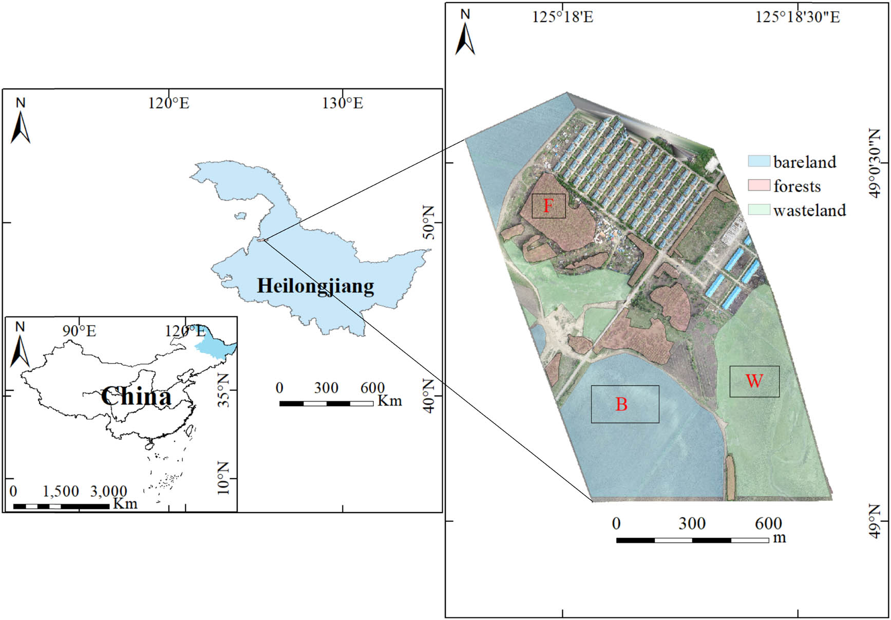
Map of the study area, including locations of the three subplots: forest (F), wasteland (W), and bare land (B) mapped using an RGB raster generated from the structure from motion (SfM) point cloud.
Figure 2 shows the workflow for producing and comparing both types of DSM. Field work was performed in May 2019 to collect both types of UAV data. The LiDAR points were acquired with a LiDAR SZT-R250 sensor onboard a DJI Matrice 600 Pro UAV. During data acquisition, the platform was operated at an altitude of 100 m and a line spacing of 75 m. The horizontal and vertical accuracies of the LiDAR sensor were 0.01 and 0.02 m, respectively. The LiDAR point densities for the forests, wastelands, and bare lands were 113.39, 65.53, and 57.95 points/m2, respectively; the SfM point densities were 116.07, 85.38, and 98.29 points/m2, respectively (Table 1). The LiDAR points were divided into ground and surface classes; only surface points were used in this study.
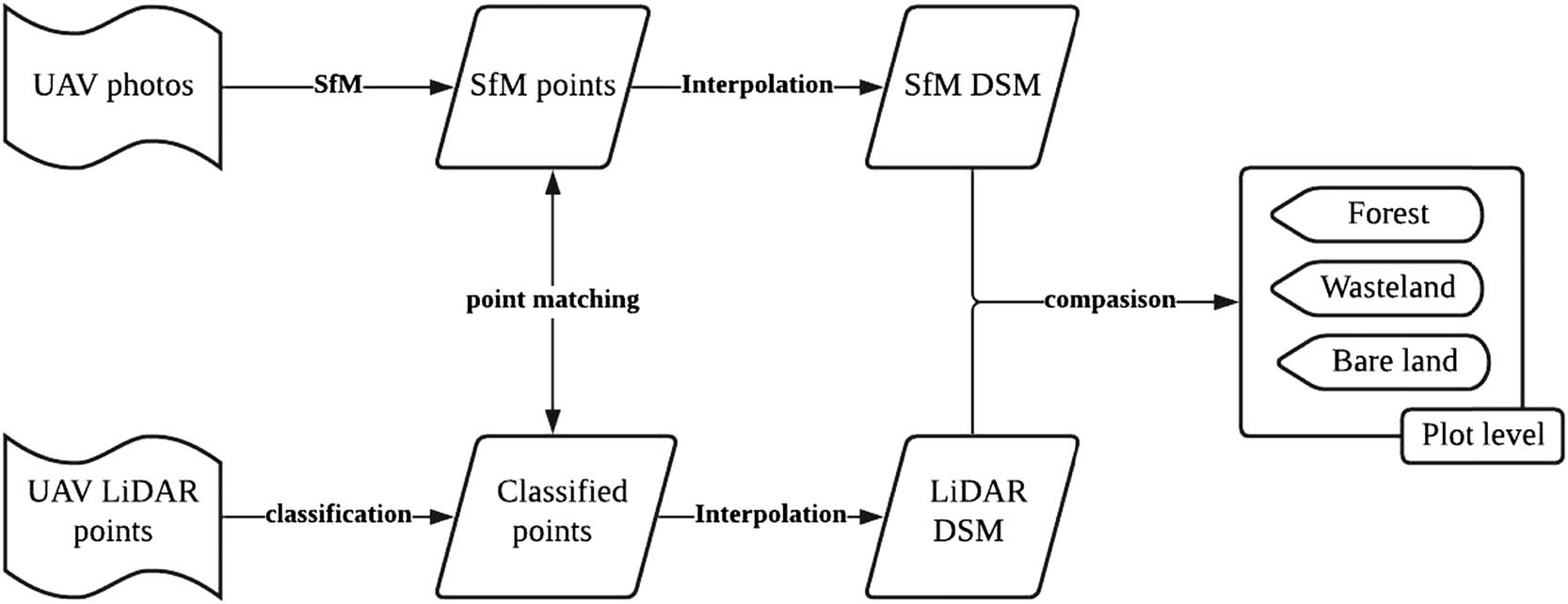
Schematic flow of this study.
Light detection and ranging (LiDAR) and unmanned aerial vehicle (UAV)-structure from motion (SfM) point densities for the three land cover types
| Forest | Waste land | Bare land | Method | |
|---|---|---|---|---|
| Plot area | 80 m × 58 m | 121 m × 76 m | 146 m × 91 m | |
| Point density (points/m2) | 113.39 | 65.53 | 57.95 | LiDAR |
| Point density (points/m2) | 116.07 | 85.38 | 98.29 | SfM |
We used a DJI Phantom 4 Pro UAV with an optical camera to capture oblique photographs for use in the SfM. The optical camera had a resolution of 20 million pixels. The UAV was operated at a height of 200 m above the ground, with a 75% heading overlap rate and 70% lateral overlap rate. A total of 197 photographs were taken from the study area. A global positioning system device onboard the UAV linked geographic location information to the optical photographs. We used Agisoft PhotoScan Professional, a commonly used SfM software, to convert the aerial photographs into dense SfM points [34]. By identifying the metadata of the photographs (such as focal length and pixel size), the software automatically corrects the inherent parameters of the camera, calculates the camera position, and produces point clouds in the general mode [35].
We used CloudCompare v2.11 alpha (Anoia) [64-bit], an open source software, to rectify the dense SfM points to the surface LiDAR points, which were used as the reference data in this work. We then conducted two steps to perform data matching in CloudCompare. Initially, wecoarsely registered both point clouds by aligning their centres with manually selected registration points. Next, we used the fine registration module to register both point clouds by minimising the overall distances between the two groups of points [36]. After point matching, we converted both types of points to raster DSMs using the inverse distance weighted (IDW) interpolation method [37] in ArcMap 10.6. We selected the IDW method, because it predicts unknown points by considering the distance between the known points. This is consistent with the first law of geography, which indicates that nearer things are more similar than distant ones [38]. In addition, the IDW method has also been used in previous similar works to interpolate point clouds to raster [9,39]. The spatial resolution of both raster DSMs was 10 cm. The differences between the two DSMs were calculated using the surface LiDAR DSM as a reference. ArcMap 10.6 and Quick Terrain Modeller v8.2.0 were used to create the figures herein.
3 Results
Figure 3 show the two types of raster DSMs and their differences; the LiDAR DSM is the reference. The elevation patterns and ranges of both DSMs were similar, showing that the surface elevation of the study area ranged from 317 to 354 m. A visual inspection indicated that the LiDAR DSM (Figure 3b) may have more detailed elevation information in the forestland areas than the SfM (Figure 3a). Most of the differences between the DSMs were less than 1 m, except for the margins around the forest areas. In addition, both DSMs showed that forests and wastelands had the highest and lowest surface elevations, respectively.
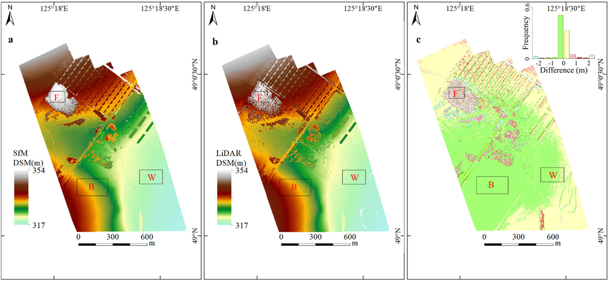
Raster digital surface models (DSMs) produced from the (a) structure from motion (SfM) point cloud and (b) light detection and ranging (LiDAR) point cloud. (c) DSM difference calculated by subtracting the unmanned aerial vehicle (UAV) LiDAR DSM from the UAV SfM DSM.
To examine the performance of the two raster DSMs with respect to the three land cover types, we calculated the difference between each set of DSM data for the three selected plots (Figure 4 and Table 1). The mean differences between the two DSMs for forests, wastelands, and bare lands were 0.413, −0.045, and −0.338 m, respectively (Table 2); and the standard deviations of the land cover types were 1.382, 0.069, and 0.06 m, respectively. In addition, the DSM difference in the forest land was the largest (12.431 m), whereas the corresponding differences for the wasteland and bare land were much smaller (0.925 and 0.650 m, respectively). The differences between the DSMs were generally the lowest for bare land and the greatest for forests. The two methods exhibited similar accuracies for wasteland and bare land.
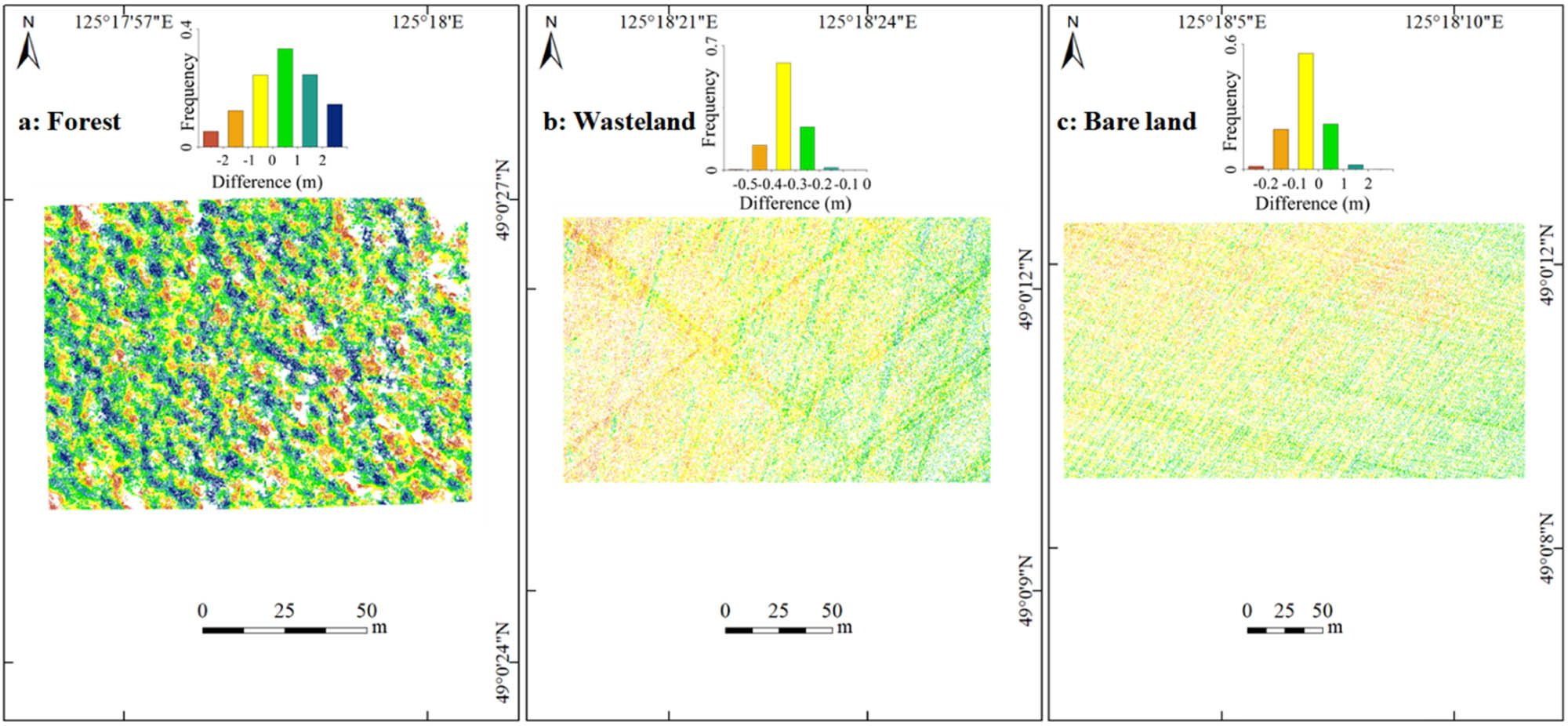
Raster digital surface model (DSM) differences between structure from motion (SfM) and light detection and ranging (LiDAR) data for (a) forests, (b) wastelands, and (c) bare lands, calculated by subtracting the unmanned aerial vehicle (UAV) LiDAR DSM from the UAV SfM DSM.
Raster digital surface model (DSM) differences between structure from motion (SfM) and light detection and ranging (LiDAR) data and calculated statistical variability in altitude over three land cover types
| Land Cover Types | Mean (m) | Std. Dev (m) | Min (m) | Max (m) | Range (m) |
|---|---|---|---|---|---|
| Forest | 0.413 | 1.382 | −5.694 | 6.737 | 12.431 |
| Waste land | −0.045 | 0.069 | −0.682 | 0.293 | 0.925 |
| Bare land | −0.338 | 0.060 | −0.682 | −0.032 | 0.650 |
Moreover, we compared both types of raster DSMs on the scatterplot for forest, wasteland, and bare land plots (Figure 5) and calculated their respective correlations based on Pearson Correlation Coefficient, which is a commonly and widely used method. The elevations extracted by the LiDAR are similar to those from the SfM for the wasteland and bare land plots, but vary for the forest plot. Furthermore, the correlations were high for the bare land (R 2 = 0.9987) and wasteland (R 2 = 0.9656) plots and low for the forest plot (R 2 = 0.6369). In the study area, the elevation of the three land cover types varied significantly; the forest, wasteland, and bare land plots were distributed over ranges of 345–355, 319–321, and 328–337 m, respectively.
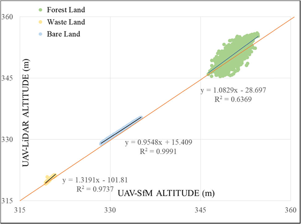
Comparisons between the unmanned aerial vehicle (UAV) structure from motion (SfM) digital surface model (DSM) and the UAV light detection and ranging (LiDAR) DSM for three land cover plots. Data correlations are shown in the scatter diagram.
To interpret the large discrepancies between the raster DSMs in the forest plot, we examined the LiDAR and SfM points and the LiDAR and SfM DSMs along the cross section of a 70 m line (Figure 6). The LiDAR and SfM DSMs differed greatly along this profile, which is consistent with the observed discrepancy in the raster DSMs for the forest. In addition, the LiDAR DSM contains more missing values than the SfM DSM and changes more dramatically. Furthermore, the raster SfM DSM has more consistent points than the LiDAR DSM. As both DSMs were converted from points, significant differences were determined using their corresponding points. Along the 70-m line, most of the SfM points changed consistently and were distributed near the SfM DSM, whereas the LiDAR points changed drastically in the forest plot.
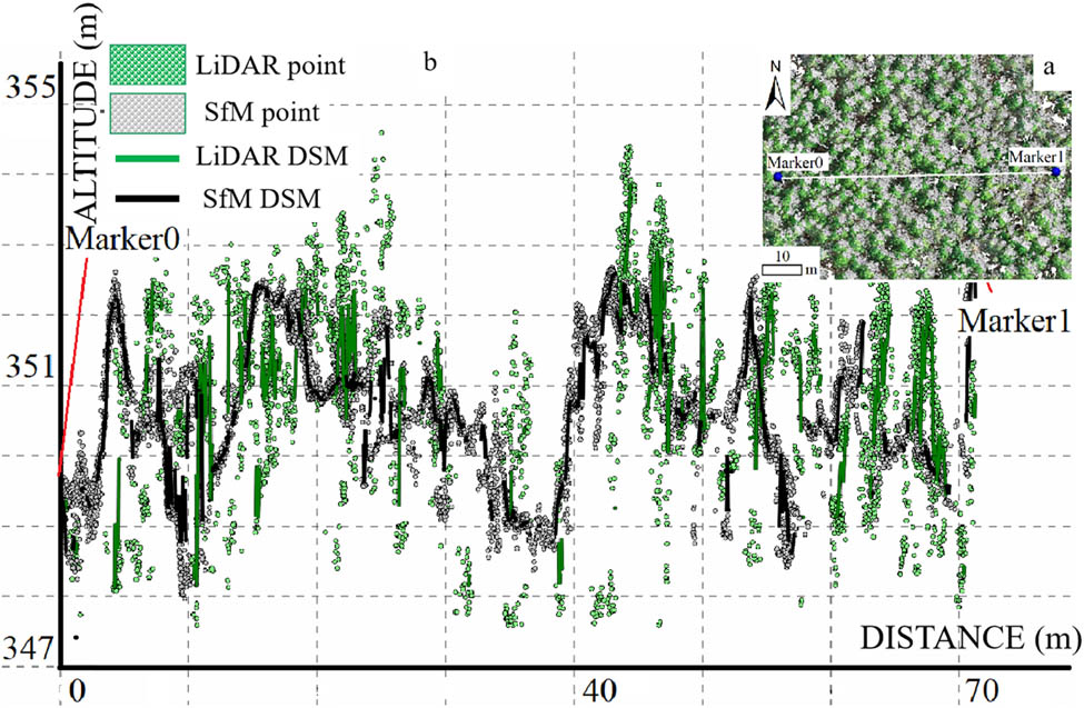
(a) Marker place in forest land and (b) side view of the two point clouds and raster digital surface models (DSMs) for forest land; wherein green represents light detection and ranging (LiDAR) point cloud, yellow represents LiDAR raster DSM, blue represents the unmanned aerial vehicle (UAV)-structure from motion (SfM) point cloud, and pink represents the UAV-SfM raster DSM.
4 Discussion
We produced two raster DSMs from SfM and LiDAR data over an area in northeast China and compared their differences for three land cover types: forests, wastelands, and bare lands. We found that the difference between the DSMs was the lowest for bare land, indicating that the SfM DSM performed better for bare land. Our results for wastelands covered by sparse vegetation were similar to those for bare land, whereas the DSM differences were the largest for forest land. The findings for bare land and wasteland were consistent with those of previous studies [26,40].
To understand the significant difference between the DSMs for the forest plot, we compared both groups of points along a 70 m line and found that the LiDAR points were less consistent with the raster DSM than the SfM points. This is because aerial photographs only capture the surface of the forest canopy [41], whereas LiDAR penetrates the vegetation canopy via gaps and obtains echo signals from both the lower and upper vegetation canopies [10]. Therefore, the SfM DSM shows the upper surface of the vegetation, and the LiDAR surface points capture a 3D interpretation of the vegetation. Further, the SfM uses photographs taken from different viewpoints, which are acquired by moving the camera forward and taking side-view photographs from nearby tracks. Feature detection and matching methods were then applied to these photos to generate point clouds [15]. The use of photographs of different viewpoints for a given locality produces unavoidable time delays, during which many unpredictable factors could influence the photographs. For example, mild wind could change the configurations of the canopy leaves. Such interferences make it difficult to track the same features in photographs from different viewpoints, reducing the number of points describing the canopy surface. Further, capturing photographs from different viewpoints in the inner part of the canopy is difficult. Therefore, compared with LiDAR, SfM captures only the surface of the vegetation canopy.
As visible light remote sensing can only obtain surface elevation information, measuring real terrain covered by dense vegetation is difficult. Thus, the wasteland and bare land vegetation in this study were mostly sparse and short; SfM obtained ground information; and the resulting DSM was similar to the LiDAR DSM.
Point cloud density is another important factor that may influence DSM accuracy and precision [26]. Rogers [26] postulated that areas with the largest errors corresponded to lower point cloud densities. In this work, we produced denser points with SfM than with LiDAR, which could minimise this influence. In addition, the point density was the highest for the forest land cover type. Further increases in the point density for the SfM and LiDAR technologies would barely improve the DSMs [42]. Therefore, land cover type is more likely than point density to influence DSM accuracy.
These results show that SfM-generated point clouds have larger errors in denser vegetation, which is consistent with previous findings [43]. In addition, compared with the LiDAR data, the SfM point data were unevenly distributed, and the vegetation canopy point cloud data obtained were less accurate. Thus, using this method to obtain point cloud data for areas covered by tall and dense vegetation is challenging.
5 Conclusion
In this study, we compared the differences between DSMs produced by airborne LiDAR and SfM for three land cover types. Both methods produced similar point densities, and the mean elevation difference between the two datasets was less than 1 m. Using the LiDAR DSM as the reference, the 95th percentile errors for the SfM DSM in the wasteland and bare land plots were 0.67 and 0.64 m, respectively. Conversely, the 95th percentile difference for the DSMs was 3.62 m for forest land covered by tall dense trees. Thus, using the SfM method to obtain a DSM with high-density vegetation is challenging, because visible light cannot penetrate dense trees; therefore, only surface information of the vegetation canopy can be obtained by SfM. These results indicate that both DSM types can be interchangeably used for wasteland and bare land areas, whereas their joint use for forestland areas is not recommended. However, acquiring higher spatial resolution UAV photographs and collecting additional ground control points may improve the accuracy of SfM-DSM in forested areas.
Although this work was performed on flat terrain, these findings are also applicable to mountainous regions. Furthermore, using UAV SfM to produce a DSM covered with dense vegetation is difficult; therefore, efforts to retrieve terrain data under vegetation cover can be challenging. Despite the flexibility of the SfM method to produce a DSM, airborne LiDAR is an indispensable method for producing digital terrains. Nevertheless, we recommend further research wherein different DSM methods are compared for use in rough terrains.
Acknowledgments
This research was funded by the National Key Research and Development Program (grant number 2018YFC0507002-03).
-
Author contributions: J. L. and W. Y. conceived and designed the experiment. J. Z. provided valuable advice for revision and reviewed the manuscript.
-
Conflict of interest: Authors state no conflict of interest.
References
[1] Grohmann CH, Garcia GPB, Affonso AA, Albuquerque RW. Dune migration and volume change from airborne LiDAR, terrestrial LiDAR and structure from motion-multi view stereo. Comput Geosci. 2020;143:1–13.10.1016/j.cageo.2020.104569Search in Google Scholar
[2] Ouedraogo MM, Degre A, Debouche C, Lisein J. The evaluation of unmanned aerial system-based photogrammetry and terrestrial laser scanning to generate DEMs of agricultural watersheds. Geomorphology. 2014;214:339–55.10.1016/j.geomorph.2014.02.016Search in Google Scholar
[3] Szypula B. Quality assessment of DEM derived from topographic maps for geomorphometric purposes. Open Geosci. 2019;11(1):843–65.10.1515/geo-2019-0066Search in Google Scholar
[4] Mora-Felix ZD, Sanhouse-Garcia AJ, Bustos-Terrones YA, Loaiza JG, Monjardin-Armenta SA, Rangel-Peraza JG. Effect of photogrammetric RPAS flight parameters on plani-altimetric accuracy of DTM. Open Geosci. 2020;12(1):1017–35.10.1515/geo-2020-0189Search in Google Scholar
[5] Barnhart KR, Rengers F, Ghent JN, Tucker GE, Wiens AM, editors. Topographic change detection at Chalk Cliffs, Colorado, USA, using airborne lidar and UAS-based structure-from-motion photogrammetry. 7th International Conference on Debris-Flow Hazards Mitigation. Colorado School of Mines; 2019.Search in Google Scholar
[6] Sofonia J, Shendryk Y, Phinn S, Roelfsema C, Kendoul F, Skocaj D. Monitoring sugarcane growth response to varying nitrogen application rates: a comparison of UAV SLAM LiDAR and photogrammetry. Int J Appl Earth Obs. 2019;82:1–15.10.1016/j.jag.2019.05.011Search in Google Scholar
[7] Swinfield T, Lindsell JA, Williams JV, Harrison RD, Gemita E, Schönlieb CB, et al. Accurate measurement of tropical forest canopy heights and aboveground carbon using structure from motion. Remote Sens. 2019;11(8):1–16.10.3390/rs11080928Search in Google Scholar
[8] Zahirieh S. A comparison of hydraulic modeling results between unmanned aerial vehicle with structure-from-motion and LIDAR produced digital elevation models. MSc thesis, George Mason University, USA; 2019.Search in Google Scholar
[9] Hosseini A, Azizi Z, Sadeghian S. Generating digital terrain model for forest areas using aerial LiDAR data case study: dorood, lorestan. Sci-Res Q Geogr Data (SEPEHR). 2020;29(113):159–67.Search in Google Scholar
[10] Lin Y-C, Cheng Y-T, Zhou T, Ravi R, Hasheminasab SM, Flatt JE, et al. Evaluation of UAV LiDAR for mapping coastal environments. Remote Sens. 2019;11(24):1–32.10.3390/rs11242893Search in Google Scholar
[11] Mezaal M, Pradhan B, Rizeei H. Improving landslide detection from airborne laser scanning data using optimized Dempster–Shafer. Remote Sens. 2018;10(7):1–26.10.3390/rs10071029Search in Google Scholar
[12] Sefercik UG, Glennie C, Singhania A, Hauser D. Area-based quality control of airborne laser scanning 3D models for different land classes using terrestrial laser scanning: sample survey in Houston, USA. Int J Remote Sens. 2015;36(23):5916–34.10.1080/01431161.2015.1110260Search in Google Scholar
[13] Puente I, González-Jorge H, Martínez-Sánchez J, Arias P. Review of mobile mapping and surveying technologies. Measurement. 2013;46(7):2127–45.10.1016/j.measurement.2013.03.006Search in Google Scholar
[14] Richardson JJ, Moskal LM. Strengths and limitations of assessing forest density and spatial configuration with aerial LiDAR. Remote Sens Environ. 2011;115(10):2640–51.10.1016/j.rse.2011.05.020Search in Google Scholar
[15] Fonstad MA, Dietrich JT, Courville BC, Jensen JL, Carbonneau PE. Topographic structure from motion: a new development in photogrammetric measurement. Earth Surf Process Landf. 2013;38(4):421–30.10.1002/esp.3366Search in Google Scholar
[16] Mwangangi KK. 3D building modelling using dense point clouds from UAV. MSc thesis, University of Twente, Netherlands; 2019.Search in Google Scholar
[17] Lucieer A, Jong SMD, Turner D. Mapping landslide displacements using structure from motion (SfM) and image correlation of multi-temporal UAV photography. Prog Phys Geogr. 2014;38(1):97–116.10.1177/0309133313515293Search in Google Scholar
[18] Izumida A, Uchiyama S, Sugai T. Application of UAV-SfM photogrammetry and aerial lidar to a disastrous flood: repeated topographic measurement of a newly formed crevasse splay of the Kinu River, central Japan. Nat Hazards Earth Syst Sci. 2017;17(9):1505–19.10.5194/nhess-17-1505-2017Search in Google Scholar
[19] Bates CB. Multi-temporal dem and land use analysis for determining gully formation. MSc thesis, San Francisco State University, USA; 2019.Search in Google Scholar
[20] Madson A, Fielding E, Sheng Y, Cavanaugh K. High-resolution spaceborne, airborne and in situ landslide kinematic measurements of the slumgullion landslide in Southwest Colorado. Remote Sens. 2019;11(3):1–26.10.3390/rs11030265Search in Google Scholar
[21] Kopysc PT. The use of aerial LiDAR and structure from motion (SfM) photogrammetry data in analyzing microtopographic changes on hiking trails on the example of Kielce (Poland). Carpathian J Earth Environ Sci. 2020;15(2):461–70.10.26471/cjees/2020/015/145Search in Google Scholar
[22] Góraj M, Karsznia K, Sikorska D, Hejduk L, Chormański J. Multi-wavelength airborne laser scanning and multispectral UAV-borne imaging. Ability to distinguish selected hydromorphological indicators. 18th International Multidisciplinary Scientific Geoconference SGEM2018. 51 Alexander Malinov blvd, Sofia, 1712, Bulgaria: SGEM OnLine Scientific Library on Earth & Planetary Sciences. 2018 Dec 3–6.10.5593/sgem2018V/1.5/S02.045Search in Google Scholar
[23] Warrick JA, Ritchie AC, Schmidt KM, Reid ME, Logan J. Characterizing the catastrophic 2017 Mud Creek landslide, California, using repeat structure-from-motion (SfM) photogrammetry. Landslides. 2019;16(6):1201–19.10.1007/s10346-019-01160-4Search in Google Scholar
[24] Guerra-Hernández J, Cosenza DN, Estraviz Rodriguez LC, Silva M, Tomé M, Díaz-Varela RA, et al. Comparison of ALS- and UAV(SfM)-derived high-density point clouds for individual tree detection in Eucalyptus plantations. Int J Remote Sens. 2018;39(15–16):5211–35.10.1080/01431161.2018.1486519Search in Google Scholar
[25] Cao L, Liu H, Fu X, Zhang Z, Shen X, Ruan H. Comparison of UAV LiDAR and digital aerial photogrammetry point clouds for estimating forest structural attributes in subtropical planted forests. Forests. 2019;10(2):1–26.10.3390/f10020145Search in Google Scholar
[26] Rogers M. Can structure from motion determine the efficacy of river re‐meandering as a natural flood management measure? MSc thesis, University of Cambridge, UK; 2017.Search in Google Scholar
[27] Cook KL. An evaluation of the effectiveness of low-cost UAVs and structure from motion for geomorphic change detection. Geomorphology. 2017;278:195–208.10.1016/j.geomorph.2016.11.009Search in Google Scholar
[28] Guisado-Pintado E, Jackson DW, Rogers D. 3D mapping efficacy of a drone and terrestrial laser scanner over a temperate beach-dune zone. Geomorphology. 2019;328:157–72.10.1016/j.geomorph.2018.12.013Search in Google Scholar
[29] Chidi CL, Zhao W, Chaudhary S, Xiong D, Wu Y. Sensitivity assessment of spatial resolution difference in DEM for soil erosion estimation based on UAV observations: an experiment on agriculture terraces in the middle hill of Nepal. ISPRS Int J Geo-Inf. 2021;10(1):1–17.10.3390/ijgi10010028Search in Google Scholar
[30] Neugirg F, Stark M, Kaiser A, Vlacilova M, Della Seta M, Vergari F, et al. Erosion processes in calanchi in the Upper Orcia Valley, Southern Tuscany, Italy based on multitemporal high-resolution terrestrial LiDAR and UAV surveys. Geomorphology. 2016;269:8–22.10.1016/j.geomorph.2016.06.027Search in Google Scholar
[31] Bernatek-Jakiel A, Jakiel M. Identification of soil piping-related depressions using an airborne LiDAR DEM: role of land use changes. Geomorphology. 2021;378:1–13.10.1016/j.geomorph.2020.107591Search in Google Scholar
[32] Migiros G, Bathrellos G, Skilodimou H, Karamousalis T. Pinios (Peneus) river (Central Greece): hydrological – geomorphological elements and changes during the quaternary. Open Geosci. 2011;3(2):215–8.10.2478/s13533-011-0019-1Search in Google Scholar
[33] Liu H, Zhang T, Liu B, Liu G, Wilson G. Effects of gully erosion and gully filling on soil depth and crop production in the black soil region, northeast China. Environ Earth Sci. 2013;68(6):1723–32.10.1007/s12665-012-1863-0Search in Google Scholar
[34] Sefercik UG, Tanrikulu F, Atalay C. Photogrammetric 3D modelling potential comparison of SFM-based new generation image matching software. The 40th Asian Conference on Remote Sensing, Korea; 2019.Search in Google Scholar
[35] Triantafyllou A, Watlet A, Le Mouélic S, Camelbeeck T, Civet F, Kaufmann O, et al. 3-D digital outcrop model for analysis of brittle deformation and lithological mapping (Lorette cave, Belgium). J Struct Geol. 2019;120:55–66.10.1016/j.jsg.2019.01.001Search in Google Scholar
[36] Sofonia JJ, Phinn S, Roelfsema C, Kendoul F, Rist Y. Modelling the effects of fundamental UAV flight parameters on LiDAR point clouds to facilitate objectives-based planning. ISPRS J Photogramm. 2019;149:105–8.10.1016/j.isprsjprs.2019.01.020Search in Google Scholar
[37] Kamiński M. DTM-based analysis of the spatial distribution of topolineaments. Open Geosci. 2020;12(1):1185–99.10.1515/geo-2020-0059Search in Google Scholar
[38] Tobler WR. A computer movie simulating urban growth in the Detroit region. Econ Geogr. 1970;46(sup1):234–40.10.2307/143141Search in Google Scholar
[39] Agüera-Vega F, Agüera-Puntas M, Martínez-Carricondo P, Mancini F, Carvajal F. Effects of point cloud density, interpolation method and grid size on derived Digital Terrain Model accuracy at micro topography level. INT J Remote Sens. 2020;41(21):8281–99.10.1080/01431161.2020.1771788Search in Google Scholar
[40] Nouwakpo SK, Weltz MA, McGwire K. Assessing the performance of structure-from-motion photogrammetry and terrestrial LiDAR for reconstructing soil surface microtopography of naturally vegetated plots. Earth Surf Process Landf. 2016;41(3):308–22.10.1002/esp.3787Search in Google Scholar
[41] Melin M, Korhonen L, Kukkonen M, Packalen P. Assessing the performance of aerial image point cloud and spectral metrics in predicting boreal forest canopy cover. ISPRS J Photogramm. 2017;129:77–85.10.1016/j.isprsjprs.2017.04.018Search in Google Scholar
[42] Fan L. A comparison between structure-from-motion and terrestrial laser scanning for deriving surface roughness: a case study on a sandy terrain surface. Int Arch Photogramm Remote Sens Spat Inf Sci. 2020;42:1225–9.10.5194/isprs-archives-XLII-3-W10-1225-2020Search in Google Scholar
[43] Sturdivant EJ, Lentz EE, Thieler ER, Farris AS, Weber KM, Remsen DP, et al. UAS-SfM for coastal research: geomorphic feature extraction and land cover classification from high-resolution elevation and optical imagery. Remote Sens. 2017;9(10):1–21.10.3390/rs9101020Search in Google Scholar
© 2021 Jianghua Liao et al., published by De Gruyter
This work is licensed under the Creative Commons Attribution 4.0 International License.
Articles in the same Issue
- Regular Articles
- Lithopetrographic and geochemical features of the Saalian tills in the Szczerców outcrop (Poland) in various deformation settings
- Spatiotemporal change of land use for deceased in Beijing since the mid-twentieth century
- Geomorphological immaturity as a factor conditioning the dynamics of channel processes in Rządza River
- Modeling of dense well block point bar architecture based on geological vector information: A case study of the third member of Quantou Formation in Songliao Basin
- Predicting the gas resource potential in reservoir C-sand interval of Lower Goru Formation, Middle Indus Basin, Pakistan
- Study on the viscoelastic–viscoplastic model of layered siltstone using creep test and RBF neural network
- Assessment of Chlorophyll-a concentration from Sentinel-3 satellite images at the Mediterranean Sea using CMEMS open source in situ data
- Spatiotemporal evolution of single sandbodies controlled by allocyclicity and autocyclicity in the shallow-water braided river delta front of an open lacustrine basin
- Research and application of seismic porosity inversion method for carbonate reservoir based on Gassmann’s equation
- Impulse noise treatment in magnetotelluric inversion
- Application of multivariate regression on magnetic data to determine further drilling site for iron exploration
- Comparative application of photogrammetry, handmapping and android smartphone for geotechnical mapping and slope stability analysis
- Geochemistry of the black rock series of lower Cambrian Qiongzhusi Formation, SW Yangtze Block, China: Reconstruction of sedimentary and tectonic environments
- The timing of Barleik Formation and its implication for the Devonian tectonic evolution of Western Junggar, NW China
- Risk assessment of geological disasters in Nyingchi, Tibet
- Effect of microbial combination with organic fertilizer on Elymus dahuricus
- An OGC web service geospatial data semantic similarity model for improving geospatial service discovery
- Subsurface structure investigation of the United Arab Emirates using gravity data
- Shallow geophysical and hydrological investigations to identify groundwater contamination in Wadi Bani Malik dam area Jeddah, Saudi Arabia
- Consideration of hyperspectral data in intraspecific variation (spectrotaxonomy) in Prosopis juliflora (Sw.) DC, Saudi Arabia
- Characteristics and evaluation of the Upper Paleozoic source rocks in the Southern North China Basin
- Geospatial assessment of wetland soils for rice production in Ajibode using geospatial techniques
- Input/output inconsistencies of daily evapotranspiration conducted empirically using remote sensing data in arid environments
- Geotechnical profiling of a surface mine waste dump using 2D Wenner–Schlumberger configuration
- Forest cover assessment using remote-sensing techniques in Crete Island, Greece
- Stability of an abandoned siderite mine: A case study in northern Spain
- Assessment of the SWAT model in simulating watersheds in arid regions: Case study of the Yarmouk River Basin (Jordan)
- The spatial distribution characteristics of Nb–Ta of mafic rocks in subduction zones
- Comparison of hydrological model ensemble forecasting based on multiple members and ensemble methods
- Extraction of fractional vegetation cover in arid desert area based on Chinese GF-6 satellite
- Detection and modeling of soil salinity variations in arid lands using remote sensing data
- Monitoring and simulating the distribution of phytoplankton in constructed wetlands based on SPOT 6 images
- Is there an equality in the spatial distribution of urban vitality: A case study of Wuhan in China
- Considering the geological significance in data preprocessing and improving the prediction accuracy of hot springs by deep learning
- Comparing LiDAR and SfM digital surface models for three land cover types
- East Asian monsoon during the past 10,000 years recorded by grain size of Yangtze River delta
- Influence of diagenetic features on petrophysical properties of fine-grained rocks of Oligocene strata in the Lower Indus Basin, Pakistan
- Impact of wall movements on the location of passive Earth thrust
- Ecological risk assessment of toxic metal pollution in the industrial zone on the northern slope of the East Tianshan Mountains in Xinjiang, NW China
- Seasonal color matching method of ornamental plants in urban landscape construction
- Influence of interbedded rock association and fracture characteristics on gas accumulation in the lower Silurian Shiniulan formation, Northern Guizhou Province
- Spatiotemporal variation in groundwater level within the Manas River Basin, Northwest China: Relative impacts of natural and human factors
- GIS and geographical analysis of the main harbors in the world
- Laboratory test and numerical simulation of composite geomembrane leakage in plain reservoir
- Structural deformation characteristics of the Lower Yangtze area in South China and its structural physical simulation experiments
- Analysis on vegetation cover changes and the driving factors in the mid-lower reaches of Hanjiang River Basin between 2001 and 2015
- Extraction of road boundary from MLS data using laser scanner ground trajectory
- Research on the improvement of single tree segmentation algorithm based on airborne LiDAR point cloud
- Research on the conservation and sustainable development strategies of modern historical heritage in the Dabie Mountains based on GIS
- Cenozoic paleostress field of tectonic evolution in Qaidam Basin, northern Tibet
- Sedimentary facies, stratigraphy, and depositional environments of the Ecca Group, Karoo Supergroup in the Eastern Cape Province of South Africa
- Water deep mapping from HJ-1B satellite data by a deep network model in the sea area of Pearl River Estuary, China
- Identifying the density of grassland fire points with kernel density estimation based on spatial distribution characteristics
- A machine learning-driven stochastic simulation of underground sulfide distribution with multiple constraints
- Origin of the low-medium temperature hot springs around Nanjing, China
- LCBRG: A lane-level road cluster mining algorithm with bidirectional region growing
- Constructing 3D geological models based on large-scale geological maps
- Crops planting structure and karst rocky desertification analysis by Sentinel-1 data
- Physical, geochemical, and clay mineralogical properties of unstable soil slopes in the Cameron Highlands
- Estimation of total groundwater reserves and delineation of weathered/fault zones for aquifer potential: A case study from the Federal District of Brazil
- Characteristic and paleoenvironment significance of microbially induced sedimentary structures (MISS) in terrestrial facies across P-T boundary in Western Henan Province, North China
- Experimental study on the behavior of MSE wall having full-height rigid facing and segmental panel-type wall facing
- Prediction of total landslide volume in watershed scale under rainfall events using a probability model
- Toward rainfall prediction by machine learning in Perfume River Basin, Thua Thien Hue Province, Vietnam
- A PLSR model to predict soil salinity using Sentinel-2 MSI data
- Compressive strength and thermal properties of sand–bentonite mixture
- Age of the lower Cambrian Vanadium deposit, East Guizhou, South China: Evidences from age of tuff and carbon isotope analysis along the Bagong section
- Identification and logging evaluation of poor reservoirs in X Oilfield
- Geothermal resource potential assessment of Erdaobaihe, Changbaishan volcanic field: Constraints from geophysics
- Geochemical and petrographic characteristics of sediments along the transboundary (Kenya–Tanzania) Umba River as indicators of provenance and weathering
- Production of a homogeneous seismic catalog based on machine learning for northeast Egypt
- Analysis of transport path and source distribution of winter air pollution in Shenyang
- Triaxial creep tests of glacitectonically disturbed stiff clay – structural, strength, and slope stability aspects
- Effect of groundwater fluctuation, construction, and retaining system on slope stability of Avas Hill in Hungary
- Spatial modeling of ground subsidence susceptibility along Al-Shamal train pathway in Saudi Arabia
- Pore throat characteristics of tight reservoirs by a combined mercury method: A case study of the member 2 of Xujiahe Formation in Yingshan gasfield, North Sichuan Basin
- Geochemistry of the mudrocks and sandstones from the Bredasdorp Basin, offshore South Africa: Implications for tectonic provenance and paleoweathering
- Apriori association rule and K-means clustering algorithms for interpretation of pre-event landslide areas and landslide inventory mapping
- Lithology classification of volcanic rocks based on conventional logging data of machine learning: A case study of the eastern depression of Liaohe oil field
- Sequence stratigraphy and coal accumulation model of the Taiyuan Formation in the Tashan Mine, Datong Basin, China
- Influence of thick soft superficial layers of seabed on ground motion and its treatment suggestions for site response analysis
- Monitoring the spatiotemporal dynamics of surface water body of the Xiaolangdi Reservoir using Landsat-5/7/8 imagery and Google Earth Engine
- Research on the traditional zoning, evolution, and integrated conservation of village cultural landscapes based on “production-living-ecology spaces” – A case study of villages in Meicheng, Guangdong, China
- A prediction method for water enrichment in aquifer based on GIS and coupled AHP–entropy model
- Earthflow reactivation assessment by multichannel analysis of surface waves and electrical resistivity tomography: A case study
- Geologic structures associated with gold mineralization in the Kirk Range area in Southern Malawi
- Research on the impact of expressway on its peripheral land use in Hunan Province, China
- Concentrations of heavy metals in PM2.5 and health risk assessment around Chinese New Year in Dalian, China
- Origin of carbonate cements in deep sandstone reservoirs and its significance for hydrocarbon indication: A case of Shahejie Formation in Dongying Sag
- Coupling the K-nearest neighbors and locally weighted linear regression with ensemble Kalman filter for data-driven data assimilation
- Multihazard susceptibility assessment: A case study – Municipality of Štrpce (Southern Serbia)
- A full-view scenario model for urban waterlogging response in a big data environment
- Elemental geochemistry of the Middle Jurassic shales in the northern Qaidam Basin, northwestern China: Constraints for tectonics and paleoclimate
- Geometric similarity of the twin collapsed glaciers in the west Tibet
- Improved gas sand facies classification and enhanced reservoir description based on calibrated rock physics modelling: A case study
- Utilization of dolerite waste powder for improving geotechnical parameters of compacted clay soil
- Geochemical characterization of the source rock intervals, Beni-Suef Basin, West Nile Valley, Egypt
- Satellite-based evaluation of temporal change in cultivated land in Southern Punjab (Multan region) through dynamics of vegetation and land surface temperature
- Ground motion of the Ms7.0 Jiuzhaigou earthquake
- Shale types and sedimentary environments of the Upper Ordovician Wufeng Formation-Member 1 of the Lower Silurian Longmaxi Formation in western Hubei Province, China
- An era of Sentinels in flood management: Potential of Sentinel-1, -2, and -3 satellites for effective flood management
- Water quality assessment and spatial–temporal variation analysis in Erhai lake, southwest China
- Dynamic analysis of particulate pollution in haze in Harbin city, Northeast China
- Comparison of statistical and analytical hierarchy process methods on flood susceptibility mapping: In a case study of the Lake Tana sub-basin in northwestern Ethiopia
- Performance comparison of the wavenumber and spatial domain techniques for mapping basement reliefs from gravity data
- Spatiotemporal evolution of ecological environment quality in arid areas based on the remote sensing ecological distance index: A case study of Yuyang district in Yulin city, China
- Petrogenesis and tectonic significance of the Mengjiaping beschtauite in the southern Taihang mountains
- Review Articles
- The significance of scanning electron microscopy (SEM) analysis on the microstructure of improved clay: An overview
- A review of some nonexplosive alternative methods to conventional rock blasting
- Retrieval of digital elevation models from Sentinel-1 radar data – open applications, techniques, and limitations
- A review of genetic classification and characteristics of soil cracks
- Potential CO2 forcing and Asian summer monsoon precipitation trends during the last 2,000 years
- Erratum
- Erratum to “Calibration of the depth invariant algorithm to monitor the tidal action of Rabigh City at the Red Sea Coast, Saudi Arabia”
- Rapid Communication
- Individual tree detection using UAV-lidar and UAV-SfM data: A tutorial for beginners
- Technical Note
- Construction and application of the 3D geo-hazard monitoring and early warning platform
- Enhancing the success of new dams implantation under semi-arid climate, based on a multicriteria analysis approach: Case of Marrakech region (Central Morocco)
- TRANSFORMATION OF TRADITIONAL CULTURAL LANDSCAPES - Koper 2019
- The “changing actor” and the transformation of landscapes