Utilization of dolerite waste powder for improving geotechnical parameters of compacted clay soil
-
Syed Husnain Ali Shah

 ,
Mohammad Arif
,
Mohammad Arif

Abstract
This study explores how dolerite cutting waste could be utilized for improving the quality of compacted clay soils. Different proportions of dolerite waste powder with varying grain sizes were used as admixtures and their impact on clay soil properties investigated. Ten samples were prepared by mixing clay soil with different proportions of dolerite waste powder having grain sizes of 0.210, 0.297, and 0.420 mm. The resulting samples were subjected to Proctor compaction, and their maximum dry density and optimum moisture content were measured. Next, all the compacted samples were subjected to geotechnical testing, including the determination of Atterberg limits, California bearing ratio (CBR), unconfined compressive strength, and specific gravity (Gs). The values of compaction parameters, Atterberg limits, and Gs were utilized for finding the porosity, void ratio, saturation potential, liquidity index (LI), and consistency index (CI). The results demonstrate that the addition of dolerite powder produces a substantial improvement in the plasticity index, compaction parameters, CBR, unconfined compressive strength, Gs, porosity, void ratio, degree of saturation, LI, and CI. The foremost reason for this improvement is the presence of denser and less water-adoring minerals in the added dolerite relative to pristine clay soil. Furthermore, the observed positive impact on the soils’ geotechnical comportment is comparatively higher with coarser than finer dolerite because of the decrease in surface area that causes a reduction in the moisture content and porosity but an increase in the density of soil.
1 Introduction
Clay soil characteristically contains a high proportion of clay particles and therefore displays high plasticity, low strength, and cohesive behavior [1]. The degree of plasticity, strength, and cohesion of clay all depend strongly on its mineralogy. The strength and volume of such soils undergo change because of fluctuation in their moisture content [2]. Circulation of water along fissures and cracks in the soil promotes the process of softening leading to a reduction in both shear strength and bearing capacity [3]. The high susceptibility of these soils to settlement under loading may cause considerable damage to the structures constructed over them. Owing to their cyclic swelling–shrinking behavior, expansive clay soil commonly causes severe damage to foundations. The extent of soil swelling and shrinkage depends on both the amount and type of clay present and environmental conditions, including climate [4,5]. Overcoming such an undesirable behavior of clay is one of the major problems and a challenging task faced by geotechnical engineers [6,7]. Such situations are particularly likely to arise during the construction of roads and highways as sites for these developmental projects undergo reduction unceasingly [6,7].
In order to modify the swelling–shrinkage properties of clay soil, extensive investigation has been carried out in the recent decades [8]. The major aim of clay soil stabilization, that is, to improve their geotechnical behavior, has been to normalize volume change and plasticity or workability characteristics, while significantly improving the strength properties [9,10,11]. In addition, the process may help in resolving problems pertaining to filtration and drainage systems [12,13], and improving permeability and enhancing the soil resistance to weathering and traffic usage, so that the requirements for specific engineering projects can be met [14]. Such a positive modification can be brought about by different options, such as removing water through draining (dewatering methods), compaction, reinforcement, and addition of materials.
Stabilization of clay soil through the addition of industrial stone and other wastes is becoming increasingly common [15,16,17,18]. Such wastes contain toxic elements that may pose serious threats to the environment by polluting both surface water and ground water. Fortunately, the extent of the expected environmental degradation can be reduced by properly utilizing these wastes [19,20,21,22]. This study utilizes dolerite waste material and aims at analyzing its impact on geotechnical properties of compacted clays. Dolerite waste was used as powder with varying grain sizes so that the role of varying the particle size in clay stabilization could be properly assessed. Besides, the present study includes determination of the liquidity index (LI), consistency index (CI), void ratio (e), porosity (n), and degree of saturation (S) of compacted clay employing weight–volume relationships. An adequate understanding of all these physical characteristics of soils is vital for appropriate foundation designing. Unfortunately, however, studies performed so far on soil stabilization have generally lacked a proper evaluation of these parameters. This work provides a methodology for determining the abovementioned properties of compacted and stabilized clay soil by utilizing the values of compaction parameters, specific gravity (Gs), and Atterberg limits.
2 Materials and methods
The materials used in the study include clay soil and dolerite rock. The dolerite rock samples were collected from a quarry site near Oghi, District Mansehra, Pakistan, whereas the sample of clay was collected from District Haripur, Pakistan (Figure 1). The collected dolerite samples were of irregular shape, truly considered as waste material as it cannot be used for dimensional, decorative, or building stone purposes. Different analyses were performed to obtain the petrographic details (mineralogical composition and texture) of the dolerite and geotechnical parameters of both the rock and soil samples. X-ray diffraction (XRD), sieve analyses, and hydrometer analysis were conducted on the soil sample, whereas the dolerite was investigated for obtaining its petrographic features and determining its unconfined compressive strength (UCS), water absorption, and Gs.

Geological map showing the location of the investigated dolerite and soil samples.
The XRD investigation of the soil sample was performed with a Bruker D8-Advance X-ray diffractometer employing the following conditions: chamber of high temperature up to 900°C with an X-ray generator KRISTALLOFLEX K 760–80 F having power supply of 3,000 W, voltage of 20–60 kV, current of 5–80 mA, and a copper anode. The XRD results revealed that the soil sample was made up of quartz, feldspar, calcite, albite, dickite, and montmorillonites. The sieve and hydrometer analyses were conducted in accordance with the standards contained in ASTM C136 [23] and ASTM 7928 [24]. Three thin sections were prepared for petrographic study of the dolerite in the Mineralogical Laboratory of Peshawar University, Pakistan. The thin sections were examined under a Fein Optic R40POL transmitted and reflected light polarizing microscope. The water absorption, Gs, and UCS of the dolerite samples were determined according to ASTM D6473 [25] and ASTM D7012 [26], respectively.
The dolerite was crushed and ground. The resulting powder was then passed through sieve numbers 40 (0.420 mm), 50 (0.297 mm), and 70 (0.210 mm) to extract samples with three different grain sizes, that is, 0.420, 0.297, and 0.210 mm. Ten samples were prepared by mixing the collected clay soil with different proportions of dolerite waste powder having different grain sizes (Table 1). All ten mixed samples were compacted using Proctor compaction, and the values of their maximum dry density (MDD) and optimum moisture content (OMC) were recorded. The geotechnical parameters, namely Atterberg limits, California bearing ratio (CBR), UCS, and Gs, of all the compacted samples were also measured. The acquired data from Atterberg limit and Gs tests were utilized for computing the porosity (n), void ratio (e), saturation (S), LI, and CI.
Composition of the investigated samples
| Sample no. | Dolerite Powder (%) | Clay Soil (%) |
|---|---|---|
| 1 | 0 | 100 |
| 2 | 10 (0.210 mm) | 90 |
| 3 | 10 (0.297 mm) | 90 |
| 4 | 10 (0.420 mm) | 90 |
| 5 | 20 (0.210 mm) | 80 |
| 6 | 20 (0.297 mm) | 80 |
| 7 | 20 (0.420 mm) | 80 |
| 8 | 30 (0.210 mm) | 70 |
| 9 | 30 (0.297 mm) | 70 |
| 10 | 30 (0.420 mm) | 70 |
The compaction parameters, that is, OMC and MDD, of the clay were determined using the standard Proctor compaction procedure according to ASTM D698 [27]. The soil Atterberg limits, which include the liquid limit (LL), plastic limit (PL), and plasticity index (PI), were determined following ASTM D4318 [28]. The CBR, UCS, and Gs of the samples were determined following the standards provided in ASTM D1883 [29], ASTM D2166-06 [30], and ASTM D854-14 [31], respectively.
The values of LI and CI were determined by following the equations used by Vardanega and Haigh’s [32] and Oliveira et al’s [33] respectively in their studies.
where w is the moisture content.
The values of OMC instead of moisture content were used as samples of compacted stabilized soil rather than natural soil were used in this investigation.
The three-phase relationships described by Budhi [34] and Arora [35] were used to determine the values of porosity, void ratio, and saturation for samples of the original and the various treated (dolerite waste powder-stabilized) soil samples. Although commonly utilized for investigating natural soils, three-phase relationships are rarely used in calculating properties of stabilized soils. The values obtained from the Proctor compaction test (Table 2) were used in the three-phase relationships for determining the abovementioned parameters.
Proctor compaction and Gs data used in the three-phase relationships for determining porosity, void ratio, degree of saturation, LI, and CI
| Samples | Wet soil weight (g) | Dry soil weight (g) | Max dry density (kN/m3) | Optimum moisture content (%) | Gs | Volume of mold (cm3) |
|---|---|---|---|---|---|---|
| Pure soil | 1,836 | 1,560 | 16.77 | 17.7 | 2.55 | 911.83 |
| Soil + 10 dolerite powder (0.210 mm) | 1,849 | 1,590 | 17.11 | 16.3 | 2.60 | 911.83 |
| Soil + 10 dolerite powder (0.297 mm) | 1,850 | 1,602 | 17.21 | 15.5 | 2.61 | 911.83 |
| Soil + 10 dolerite powder (0.420 mm) | 1,874 | 1,630 | 17.51 | 15.0 | 2.63 | 911.83 |
| Soil + 20 dolerite powder (0.210 mm) | 1,871 | 1,655 | 17.80 | 13.1 | 2.66 | 911.83 |
| Soil + 20 dolerite powder (0.297 mm) | 1,888 | 1,680 | 18.10 | 12.4 | 2.68 | 911.83 |
| Soil + 20 dolerite powder (0.420 mm) | 1,925 | 1,725 | 18.50 | 11.6 | 2.70 | 911.83 |
| Soil + 30 dolerite powder (0.210 mm) | 1,936 | 1,760 | 18.91 | 10.0 | 2.74 | 911.83 |
| Soil + 30 dolerite powder (0.297 mm) | 1,940 | 1,780 | 19.13 | 8.99 | 2.77 | 911.83 |
| Soil + 30 dolerite powder (0.420 mm) | 1,971 | 1,825 | 19.61 | 8.01 | 2.81 | 911.83 |
The following formula was used to determine the void ratios:
where e is the void ratio and V v and V s represent the volumes of voids and solids, respectively.
For V s determination, we used the derived weight and volume relationship as follows:
where V s and γs represent the volume and weight (i.e., the weight of soil without water) of solids, respectively; r w is the unit weight of water (standard value 0.99), and Gs refers to specific gravity.
The value of the weight of solids obtained from the Proctor compaction test was used, that is, weight of the dry soil used in the determination of MDD (Table 2), whereas the value of Gs was determined through laboratory test.
For the determination of V v, we used the formula V T + V s = V v, where V T is the total volume of soil; V s is the volume of solids; and V v is the volume of voids.
The total volume (V T), which was obtained by performing the Proctor compaction test (Table 2), is the volume of the standard Proctor mold.
Porosity of the samples was determined from the following equation:
where n = porosity, V v = volume of voids, and V T = total volume of the soil.
Porosity can also be determined by using the values of n and e as follows:
The following weight–volume relationship was used for determining the degree of saturation:
where S refers to the degree of saturation; w is the moisture content (here replaced with OMC); Gs is the specific gravity; and e is the void ratio.
3 Results
The soil sample was made up of both clay and nonclay minerals. Dickite and montmorillonites are the major clay minerals, whereas quartz, feldspar, albite, and calcite represent the nonclay constituents of the soil. As shown in Figure 2, 80% of the soil sample consists of material finer than 200 mesh. Petrographic data indicate that the dolerite samples contain plagioclase (49–51%), clinopyroxene (40–43%), and opaque minerals (7–9%) (Figure 3). The geotechnical parameters of dolerite are given in Table 3.
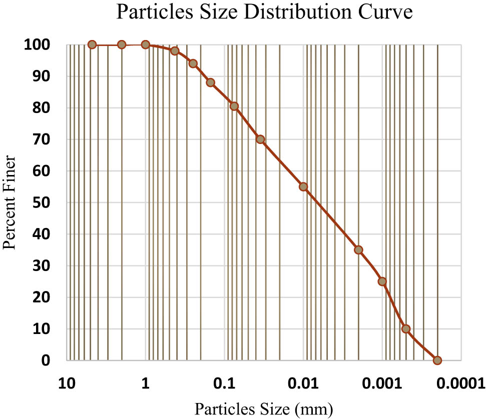
Grain size distribution of the investigated soil sample.

Petrographic results of the dolerite sample used for stabilization (OM = opaque mineral, Pg = plagioclase, CPx = clinopyroxene).
Geotechnical properties of dolerite
| Water absorption (%) | 0.69 |
| Gs | 3.12 |
| UCS (MPa) | 225.87 |
Data on the Atterberg limits, which include LL, PL, and PI, are shown in Figure 4. The addition of dolerite powder obviously reduced the values of both LL and PI. Besides, the treatment caused augmentation, though very little, in the values of PL. Although the addition of dolerite powder of any size improved the Atterberg limits, the impact of the coarse-grained powder varieties was relatively greater than that of the finer ones. The values of the Atterberg limits are used also for characterizing the investigated clay soil by using the American Association of State Highway and Transportation Officials soil classification system (Figure 5). Although the original (untreated) soil sample was classified as A7-6 type, the up to 30% addition of dolerite powder with different grain sizes as an admixture upgraded the soil to A4 type.
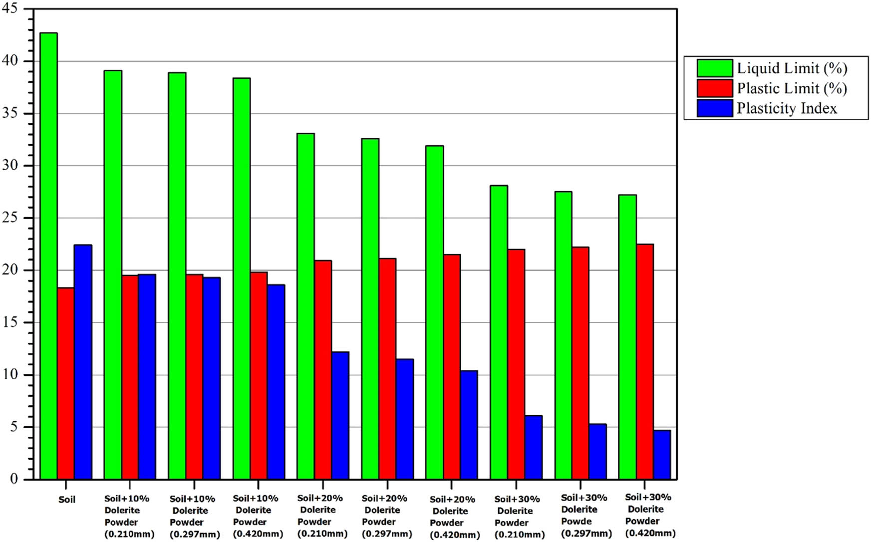
Variation in the Atterberg limits of the original (untreated) and variously treated soil samples.

Geotechnical characterization of the untreated and variously treated soil samples.
The values of compaction parameters (MDD and OMC) are displayed in Figure 6a. The addition of dolerite powder significantly improved the soil in terms of these two parameters, that is, enhancement in MDD and reduction in OMC. The observed positive impact on both the compaction properties is higher from coarser than the finer powders.


Impact of the amount and grain size of dolerite powder on the geochemical parameters of clay soil: (a) compaction parameters, (b) Gs, (c) porosity, (d) void ratio, (e) degree of saturation, (f) CI, and (g) LI.
The impact of addition of dolerite powder on the soil Gs is illustrated in Figure 6b. As shown in the figure, an increase in the amount of the added dolerite powder enhances Gs. Addition of the dolerite powders reduced the values of porosity, void ratio, and degree of saturation, and hence improved the quality of soil especially its CBR and UCS (Figures 6c–e and 7a and b). The finer powders diminished these parameters to a lesser extent than the coarser powders. The data on CI and LI for the studied soil samples are shown in Figure 6f and g. The addition of dolerite led to an enhancement in CI and reduction in LI, that is, an improvement in the soil quality. The coarser dolerite powder caused greater improvement than the medium and finer ones.

(a) Impact of the amount and grain size of dolerite powder on the CBR of clay soil. (b) Impact of the amount and grain size of dolerite powder on the UCS of clay soil.
4 Discussion
Knowledge of the Atterberg limits, compaction properties, and strength parameters is important for a better understanding of the behavior of clay soil, especially its bearing capacity and consolidation. The investigated clay soil is weak and of poor quality (Figure 5) as it exhibited high LL, OMC, and PI, and low CBR and UCS, most probably because of dickite and montmorillonite as its constituents. The addition of three different proportions of dolerite waste as powder with varying grain sizes has improved all these parameters. The values of LL, PI, and OMC were utilized also for determining the CI and LI values of the soil. Although being very important parameters for explaining the geotechnical behavior of soil, CI and LI had rarely been included in most of the previously published studies on soil stabilization. The LI is a measure of the extent of closeness of the soil moisture content to its LL. Where the soil is at its LL, the value of its LI is 100% and the soil acts as a liquid. In contrast, zero LI means that the soil is at its PL, while negative values of LI indicate that the water content of soil is lower than its PL and so the soil is hard [35]. In the present study, it was observed that the addition of dolerite powder reduced the values of LI, which means that the soil was getting harder, and led to an improvement in its bearing capacity.
A soil with zero CI means that it is in the liquid state and thus very soft and weak, whereas soil possessing high (e.g., 100) CI indicates that it is in the plastic state, that is, it is firmer/stronger. The soil becomes strong when its CI exceeds 100; increases in CI beyond 100 increases the strength of the soil significantly [34]. Dolerite addition enhances the soil CI and thus its suitability for construction. A possible reason for such a significant improvement in the Atterberg limits as well as of LI and CI could be that, unlike the untreated soil, the added dolerite waste powder can hold a very low amount of water (Table 3). The low water absorption capacity of dolerite is because it contains high amount of clinopyroxene and plagioclase minerals that are less hydrophilic (Figure 3). The addition of dolerite and thus less hydrophilic constituents reduces the concentration of water-friendly clay minerals in the treated soil. As a result, the water absorption capacity and hence the values of Atterberg limits and consistency parameters of the dolerite-treated soil samples are diminished. Similar improvements were also documented by various researchers [15,16,17,18,36,37] in their studies regarding clay stabilization through a variety of rock and industrial stone admixtures.
Characterization based on Atterberg limits groups the clay soil from the study area with soil of the A7-6 type (Figure 5). According to the relevant AASHTO standards, the strength of A7-6 soils is fair to poor. The addition of up to 30% dolerite waste powder upgrades the investigated soil to the A4-type, whose strength is considered to be excellent to good (AASHTO classification). The observed significant improvement in strength shows the suitability of dolerite waste for stabilization of clay soils.
The treatment with dolerite waste results in a reduction in the soil porosity, void ratio, and degree of saturation in addition to improving the compaction and strength parameters. The soil porosity, void ratio, and degree of saturation are directly related to soil bearing capacity as a reduction in their values enhances the soil’s MDD, CBR, and UCS and hence lessens settlement issues. The observed increase in MDD, CBR, and UCS is obviously because the added dolerite waste powder is markedly denser than the pristine soil.
In addition to amount, grain size of the admixture is also found to be important in improving the geotechnical quality of soil as the addition of equal amount (e.g., 30%) of compositionally the same dolerite powder but with different grain sizes improves the soil properties to significantly different levels. Specifically, the impact of coarser admixture on soil stabilization is considerably higher than that caused by finer but otherwise similar substance. One of the possible explanations for this disparity could be that an increase in grain size leads to a decrease in specific surface area and thus a reduction in the moisture content, porosity, and enhancement in density, which in turn lowers the LL, PI, LI, porosity, degree of saturation, and void ratio, and enhances the values of PL, CI, MDD, UCS, and CBR.
5 Conclusion
Results from the current investigation lead to the following conclusions:
The data on compaction parameters, Gs, and Atterberg limits can be used effectively in weight–volume relationships for the determination of void ratio, porosity, degree of saturation, LI, and CI of compacted clay.
The addition of up to 30% dolerite powder significantly improves the geotechnical quality of compacted clay by (a) enhancing MDD, UCS, CBR, CI, and Gs and (b) significantly reducing porosity, void ratio, degree of saturation, OMC, LL, and PI. Hence, dolerite powder can be used as an admixture for clay stabilization.
The positive impact on compacted clays is higher from coarser than finer dolerite powders.
-
Author contributions: This study is designed and completed by Syed Husnain Ali Shah (Lecturer, Department of Earth and Environmental Sciences, Hazara University, Mansehra, Pakistan) as the principal investigator under the guidance and technical support of Dr. Mohammad Arif (PhD, Leicester University, England). Dr. Arif also helped in manuscript writing and proofreading. Mr. Qasim ur Rehman (Assistant Professor, Department of Earth Sciences, University of Haripur, Haripur, Pakistan) and Mr. Fawaz Manzoor (PhD scholar, Department of Earth Sciences, University of Haripur, Haripur, Pakistan) performed the unconfined compressive strength test and also helped in the improvement of figures.
-
Conflict of interest: Authors state no conflict of interest.
References
[1] Zaliha SZS, Kamarudin H, Mustafa AL, Bakri AM, Binhussain M, Salwa MSS. Review on soil stabilization techniques. Aus J Basic Appl Sci. 2013;7:258–65.Suche in Google Scholar
[2] Wheeler SJ, Sharma RS, Buisson MSR. Coupling of hydraulic hysteresis and stress-strain behaviour in unsaturated soils. Geotechnique. 2003;53:41–54. 10.1680/geot.2003.53.1.41 Suche in Google Scholar
[3] Dhakar S, Jain SK. Stabilization of soil: a review. Int J Sci Res (IJSR). 2016;5(6):545–9.10.21275/v5i6.NOV164184Suche in Google Scholar
[4] Puppala AJ, Pokala S, Intharasombat N, Williammee R. Effects of organic matter on physical, strength and volume change properties of compost amended expansive clay. ASCE, J Geotech Geoenviron Eng. 2007;133(11):1449–61.10.1061/(ASCE)1090-0241(2007)133:11(1449)Suche in Google Scholar
[5] Puppala AJ, Manosuthkij T, Hoyos LR. Better characterization of expansive soils for the design of pavement infrastructure. In Infrastructure development on expansive soils. Index 2009 Proceedings; 2009. p. 74–89.Suche in Google Scholar
[6] Fauzi A, Nazmi WM, Fauzi UJ. Subgrade stabilization of Kuantan clay using fly ash and bottom ash. In The 8th International Conference on Geotechnical and Transportation Engineering Geotropika; 2010.Suche in Google Scholar
[7] Cristelo N, Glendinning S, Miranda T, Oliveira D, Silva R. Soil stabilisation using alkaline activation of fly ash for self-compacting rammed earth construction. Constr Build Mater. 2012;36:727–35.10.1016/j.conbuildmat.2012.06.037Suche in Google Scholar
[8] Jayapal J, Boobathiraja S, Thanaraj SM, Priyadarshini K. Weak soil stabilization using different admixtures-a comparative study. Int J Eng Res Technol (IJERT). 2014;3(10):57–63.Suche in Google Scholar
[9] Petry T, Little D. Review of stabilization of clays and expansive soils in pavements and lightly loaded structures – history, practice and future. J Mater Civ Eng. 2002;14(6):447–60.10.1061/(ASCE)0899-1561(2002)14:6(447)Suche in Google Scholar
[10] Soltani A, Taheri A, Khatibi M, Estabragh AR. Swelling potential of a stabilised expansive soil: a comparative experimental study. Geotech Geol Eng. 2017;35(4):1717–44.10.1007/s10706-017-0204-1Suche in Google Scholar
[11] Soltani A, Deng A, Taheri A, Mirzababaei M. Rubber powder-polymer combined stabilization of South Australian expansive soils. Geosynth Int. 2018;25(3):304–21.10.1680/jgein.18.00009Suche in Google Scholar
[12] Bergado D, Anderson L, Miura N, Balasubramaniam A. Soft ground improvement: in lawland and other environment. New York: American Society of Civil Engineers; 1996.Suche in Google Scholar
[13] Prabakar J, Dendorkar N, Morchhale RK. Influence of fly ash on strength behavior of typical soils. Constr Build Mater. 2004;18:263–76.10.1016/j.conbuildmat.2003.11.003Suche in Google Scholar
[14] Kolias S, Rigopoulou VK, Karaholias A. Stabilization of clayey soils with high calcium fly ash and cement. Cem Concr Compos. 2005;27:310–3.10.1016/j.cemconcomp.2004.02.019Suche in Google Scholar
[15] Shah SHA, Arif M, Asif ME, Safdar M. Influence of granite cutting waste addition on the geotechnical parameters of cohesive soil. Int J Eng Res Adv Technol. 2019;5:64–74. 10.31695/IJERAT.2019.3459.Suche in Google Scholar
[16] Saygılı Al. Use of waste marble dust for stabilization of clayey soil. Mater Sci. 2015;21(4):601–6. 10.5755/j01.ms.21.4.11966.Suche in Google Scholar
[17] Sivrikaya O, Kıyıldı RK, Karaca Z. Recycling waste from natural stone processing plants to stabilise clayey soil. Env Earth Sci. 2014;71:4397–407.10.1007/s12665-013-2833-xSuche in Google Scholar
[18] Cabalar AF, Alosman SO. Influence of rock powder on the behaviour of an organic soil. Bull Eng Geol Env. 2021;80:8665–76.10.1007/s10064-021-02457-2Suche in Google Scholar
[19] Arulrajah A, Piratheepan J, Disfani MM, Bo MW. Geotechnical and geo-environmental properties of recycled construction and demolition materials in pavement subbase applications. J Mater Civ Eng. 2013;25:1077–88. 10.1061/(ASCE)MT.1943-5533.0000652 Suche in Google Scholar
[20] Cabalar AF, Abdulnafaa MD, Karbash Z. Influences of various construction and demolition materials on the behavior of a clay. Environ Earth Sci. 2016;75(9):841. 10.1007/s12665-016-5631-4 Suche in Google Scholar
[21] Arulrajah A, Disfani MM, Horpibulsuk S, Suksiripattanapong C, Prongmanee N. Physical properties and shear strength responses of recycled construction and demolition materials in unbound pavement base/subbase applications. Constr Build Mater. 2020;58:245–57.10.1016/j.conbuildmat.2014.02.025Suche in Google Scholar
[22] Cabalar AF, Ismael IA, Yavuz A. Use of zinc coated steel CNC milling waste for road pavement subgrade. Transport Geotech. 2020;23:100342.10.1016/j.trgeo.2020.100342Suche in Google Scholar
[23] ASTM C136/C136M. Standard test method for sieve analysis of fine and coarse aggregates. West Conshohocken, PA: ASTM International; 2019.Suche in Google Scholar
[24] ASTM D7928-17. Standard test method for particle-size distribution (gradation) of finegrained soils using the sedimentation (hydrometer) analysis. West Conshohocken, PA: ASTM International; 2017.Suche in Google Scholar
[25] ASTM D6473. Standard test method for specific gravity and absorption of rock for erosion control. West Conshohocken, PA: ASTM International; 2015.Suche in Google Scholar
[26] ASTM D7012-14e1. Standard test methods for compressive strength and elastic moduli of intact rock core specimens under varying states of stress and temperatures. West Conshohocken, PA: ASTM International; 2014.Suche in Google Scholar
[27] ASTM D698. Standard test method for laboratory compaction characteristics of soil using standard effort. West Conshohocken, PA: ASTM International; 2000.Suche in Google Scholar
[28] ASTM D4318. Standard test methods for liquid limit, plastic limit and plasticity index of soils. West Conshohocken, PA; 2000.Suche in Google Scholar
[29] ASTM D1883. Standard test method for CBR (California bearing ratio) of laboratory compacted soils. West Conshohocken, PA, USA: ASTM International; 1999.Suche in Google Scholar
[30] ASTM D2166-06. Standard test method for unconfined compressive strength of cohesive soil. West Conshohocken, PA, USA: ASTM International; 2006.Suche in Google Scholar
[31] ASTM D854. Standard test methods for specific gravity of soil solids by water pycnometer. West Conshohocken, PA: ASTM International; 2014.Suche in Google Scholar
[32] Vardanega PJ, Haigh SK. The undrained strength – liquidity index relationship. Can Geotech J. 2014;51:1073–86. 10.1139/cgj-2013-0169.Suche in Google Scholar
[33] Oliveira DGG, Thewes M, Diederichs MS, Langmaack L. Consistency index and its correlation with EPB excavation of mixed clay–sand soils. Geotech Geol Eng. 2019;37(1):327–45. 10.1007/s10706-018-0612-x.Suche in Google Scholar
[34] Budhi M. Soil mechanics and foundations. 3rd edn. USA: Wiley & Sons, INC; 2010.Suche in Google Scholar
[35] Arora KR. Soil mechanics and foundation engineering. In SI Units. New Delhi, India: Standard Publishers Distributions; 2000.Suche in Google Scholar
[36] Shah SHA, Arif M, Sabir MA, Iqbal J. In-situ stabilization of clays with lime, dolerite and quartzite powders. Acta Geodyn Geomater. 2020;3(199):341–52. 10.13168/AGG.2020.0025.Suche in Google Scholar
[37] Shah SHA, Arif M, Sabir MA, Rehman Q. Impact of igneous rock admixtures on geotechnical properties of lime stabilized clay. Civ Environ Eng. 2020;16:329–39. 10.2478/cee-2020-0033.Suche in Google Scholar
© 2021 Syed Husnain Ali Shah et al., published by De Gruyter
This work is licensed under the Creative Commons Attribution 4.0 International License.
Artikel in diesem Heft
- Regular Articles
- Lithopetrographic and geochemical features of the Saalian tills in the Szczerców outcrop (Poland) in various deformation settings
- Spatiotemporal change of land use for deceased in Beijing since the mid-twentieth century
- Geomorphological immaturity as a factor conditioning the dynamics of channel processes in Rządza River
- Modeling of dense well block point bar architecture based on geological vector information: A case study of the third member of Quantou Formation in Songliao Basin
- Predicting the gas resource potential in reservoir C-sand interval of Lower Goru Formation, Middle Indus Basin, Pakistan
- Study on the viscoelastic–viscoplastic model of layered siltstone using creep test and RBF neural network
- Assessment of Chlorophyll-a concentration from Sentinel-3 satellite images at the Mediterranean Sea using CMEMS open source in situ data
- Spatiotemporal evolution of single sandbodies controlled by allocyclicity and autocyclicity in the shallow-water braided river delta front of an open lacustrine basin
- Research and application of seismic porosity inversion method for carbonate reservoir based on Gassmann’s equation
- Impulse noise treatment in magnetotelluric inversion
- Application of multivariate regression on magnetic data to determine further drilling site for iron exploration
- Comparative application of photogrammetry, handmapping and android smartphone for geotechnical mapping and slope stability analysis
- Geochemistry of the black rock series of lower Cambrian Qiongzhusi Formation, SW Yangtze Block, China: Reconstruction of sedimentary and tectonic environments
- The timing of Barleik Formation and its implication for the Devonian tectonic evolution of Western Junggar, NW China
- Risk assessment of geological disasters in Nyingchi, Tibet
- Effect of microbial combination with organic fertilizer on Elymus dahuricus
- An OGC web service geospatial data semantic similarity model for improving geospatial service discovery
- Subsurface structure investigation of the United Arab Emirates using gravity data
- Shallow geophysical and hydrological investigations to identify groundwater contamination in Wadi Bani Malik dam area Jeddah, Saudi Arabia
- Consideration of hyperspectral data in intraspecific variation (spectrotaxonomy) in Prosopis juliflora (Sw.) DC, Saudi Arabia
- Characteristics and evaluation of the Upper Paleozoic source rocks in the Southern North China Basin
- Geospatial assessment of wetland soils for rice production in Ajibode using geospatial techniques
- Input/output inconsistencies of daily evapotranspiration conducted empirically using remote sensing data in arid environments
- Geotechnical profiling of a surface mine waste dump using 2D Wenner–Schlumberger configuration
- Forest cover assessment using remote-sensing techniques in Crete Island, Greece
- Stability of an abandoned siderite mine: A case study in northern Spain
- Assessment of the SWAT model in simulating watersheds in arid regions: Case study of the Yarmouk River Basin (Jordan)
- The spatial distribution characteristics of Nb–Ta of mafic rocks in subduction zones
- Comparison of hydrological model ensemble forecasting based on multiple members and ensemble methods
- Extraction of fractional vegetation cover in arid desert area based on Chinese GF-6 satellite
- Detection and modeling of soil salinity variations in arid lands using remote sensing data
- Monitoring and simulating the distribution of phytoplankton in constructed wetlands based on SPOT 6 images
- Is there an equality in the spatial distribution of urban vitality: A case study of Wuhan in China
- Considering the geological significance in data preprocessing and improving the prediction accuracy of hot springs by deep learning
- Comparing LiDAR and SfM digital surface models for three land cover types
- East Asian monsoon during the past 10,000 years recorded by grain size of Yangtze River delta
- Influence of diagenetic features on petrophysical properties of fine-grained rocks of Oligocene strata in the Lower Indus Basin, Pakistan
- Impact of wall movements on the location of passive Earth thrust
- Ecological risk assessment of toxic metal pollution in the industrial zone on the northern slope of the East Tianshan Mountains in Xinjiang, NW China
- Seasonal color matching method of ornamental plants in urban landscape construction
- Influence of interbedded rock association and fracture characteristics on gas accumulation in the lower Silurian Shiniulan formation, Northern Guizhou Province
- Spatiotemporal variation in groundwater level within the Manas River Basin, Northwest China: Relative impacts of natural and human factors
- GIS and geographical analysis of the main harbors in the world
- Laboratory test and numerical simulation of composite geomembrane leakage in plain reservoir
- Structural deformation characteristics of the Lower Yangtze area in South China and its structural physical simulation experiments
- Analysis on vegetation cover changes and the driving factors in the mid-lower reaches of Hanjiang River Basin between 2001 and 2015
- Extraction of road boundary from MLS data using laser scanner ground trajectory
- Research on the improvement of single tree segmentation algorithm based on airborne LiDAR point cloud
- Research on the conservation and sustainable development strategies of modern historical heritage in the Dabie Mountains based on GIS
- Cenozoic paleostress field of tectonic evolution in Qaidam Basin, northern Tibet
- Sedimentary facies, stratigraphy, and depositional environments of the Ecca Group, Karoo Supergroup in the Eastern Cape Province of South Africa
- Water deep mapping from HJ-1B satellite data by a deep network model in the sea area of Pearl River Estuary, China
- Identifying the density of grassland fire points with kernel density estimation based on spatial distribution characteristics
- A machine learning-driven stochastic simulation of underground sulfide distribution with multiple constraints
- Origin of the low-medium temperature hot springs around Nanjing, China
- LCBRG: A lane-level road cluster mining algorithm with bidirectional region growing
- Constructing 3D geological models based on large-scale geological maps
- Crops planting structure and karst rocky desertification analysis by Sentinel-1 data
- Physical, geochemical, and clay mineralogical properties of unstable soil slopes in the Cameron Highlands
- Estimation of total groundwater reserves and delineation of weathered/fault zones for aquifer potential: A case study from the Federal District of Brazil
- Characteristic and paleoenvironment significance of microbially induced sedimentary structures (MISS) in terrestrial facies across P-T boundary in Western Henan Province, North China
- Experimental study on the behavior of MSE wall having full-height rigid facing and segmental panel-type wall facing
- Prediction of total landslide volume in watershed scale under rainfall events using a probability model
- Toward rainfall prediction by machine learning in Perfume River Basin, Thua Thien Hue Province, Vietnam
- A PLSR model to predict soil salinity using Sentinel-2 MSI data
- Compressive strength and thermal properties of sand–bentonite mixture
- Age of the lower Cambrian Vanadium deposit, East Guizhou, South China: Evidences from age of tuff and carbon isotope analysis along the Bagong section
- Identification and logging evaluation of poor reservoirs in X Oilfield
- Geothermal resource potential assessment of Erdaobaihe, Changbaishan volcanic field: Constraints from geophysics
- Geochemical and petrographic characteristics of sediments along the transboundary (Kenya–Tanzania) Umba River as indicators of provenance and weathering
- Production of a homogeneous seismic catalog based on machine learning for northeast Egypt
- Analysis of transport path and source distribution of winter air pollution in Shenyang
- Triaxial creep tests of glacitectonically disturbed stiff clay – structural, strength, and slope stability aspects
- Effect of groundwater fluctuation, construction, and retaining system on slope stability of Avas Hill in Hungary
- Spatial modeling of ground subsidence susceptibility along Al-Shamal train pathway in Saudi Arabia
- Pore throat characteristics of tight reservoirs by a combined mercury method: A case study of the member 2 of Xujiahe Formation in Yingshan gasfield, North Sichuan Basin
- Geochemistry of the mudrocks and sandstones from the Bredasdorp Basin, offshore South Africa: Implications for tectonic provenance and paleoweathering
- Apriori association rule and K-means clustering algorithms for interpretation of pre-event landslide areas and landslide inventory mapping
- Lithology classification of volcanic rocks based on conventional logging data of machine learning: A case study of the eastern depression of Liaohe oil field
- Sequence stratigraphy and coal accumulation model of the Taiyuan Formation in the Tashan Mine, Datong Basin, China
- Influence of thick soft superficial layers of seabed on ground motion and its treatment suggestions for site response analysis
- Monitoring the spatiotemporal dynamics of surface water body of the Xiaolangdi Reservoir using Landsat-5/7/8 imagery and Google Earth Engine
- Research on the traditional zoning, evolution, and integrated conservation of village cultural landscapes based on “production-living-ecology spaces” – A case study of villages in Meicheng, Guangdong, China
- A prediction method for water enrichment in aquifer based on GIS and coupled AHP–entropy model
- Earthflow reactivation assessment by multichannel analysis of surface waves and electrical resistivity tomography: A case study
- Geologic structures associated with gold mineralization in the Kirk Range area in Southern Malawi
- Research on the impact of expressway on its peripheral land use in Hunan Province, China
- Concentrations of heavy metals in PM2.5 and health risk assessment around Chinese New Year in Dalian, China
- Origin of carbonate cements in deep sandstone reservoirs and its significance for hydrocarbon indication: A case of Shahejie Formation in Dongying Sag
- Coupling the K-nearest neighbors and locally weighted linear regression with ensemble Kalman filter for data-driven data assimilation
- Multihazard susceptibility assessment: A case study – Municipality of Štrpce (Southern Serbia)
- A full-view scenario model for urban waterlogging response in a big data environment
- Elemental geochemistry of the Middle Jurassic shales in the northern Qaidam Basin, northwestern China: Constraints for tectonics and paleoclimate
- Geometric similarity of the twin collapsed glaciers in the west Tibet
- Improved gas sand facies classification and enhanced reservoir description based on calibrated rock physics modelling: A case study
- Utilization of dolerite waste powder for improving geotechnical parameters of compacted clay soil
- Geochemical characterization of the source rock intervals, Beni-Suef Basin, West Nile Valley, Egypt
- Satellite-based evaluation of temporal change in cultivated land in Southern Punjab (Multan region) through dynamics of vegetation and land surface temperature
- Ground motion of the Ms7.0 Jiuzhaigou earthquake
- Shale types and sedimentary environments of the Upper Ordovician Wufeng Formation-Member 1 of the Lower Silurian Longmaxi Formation in western Hubei Province, China
- An era of Sentinels in flood management: Potential of Sentinel-1, -2, and -3 satellites for effective flood management
- Water quality assessment and spatial–temporal variation analysis in Erhai lake, southwest China
- Dynamic analysis of particulate pollution in haze in Harbin city, Northeast China
- Comparison of statistical and analytical hierarchy process methods on flood susceptibility mapping: In a case study of the Lake Tana sub-basin in northwestern Ethiopia
- Performance comparison of the wavenumber and spatial domain techniques for mapping basement reliefs from gravity data
- Spatiotemporal evolution of ecological environment quality in arid areas based on the remote sensing ecological distance index: A case study of Yuyang district in Yulin city, China
- Petrogenesis and tectonic significance of the Mengjiaping beschtauite in the southern Taihang mountains
- Review Articles
- The significance of scanning electron microscopy (SEM) analysis on the microstructure of improved clay: An overview
- A review of some nonexplosive alternative methods to conventional rock blasting
- Retrieval of digital elevation models from Sentinel-1 radar data – open applications, techniques, and limitations
- A review of genetic classification and characteristics of soil cracks
- Potential CO2 forcing and Asian summer monsoon precipitation trends during the last 2,000 years
- Erratum
- Erratum to “Calibration of the depth invariant algorithm to monitor the tidal action of Rabigh City at the Red Sea Coast, Saudi Arabia”
- Rapid Communication
- Individual tree detection using UAV-lidar and UAV-SfM data: A tutorial for beginners
- Technical Note
- Construction and application of the 3D geo-hazard monitoring and early warning platform
- Enhancing the success of new dams implantation under semi-arid climate, based on a multicriteria analysis approach: Case of Marrakech region (Central Morocco)
- TRANSFORMATION OF TRADITIONAL CULTURAL LANDSCAPES - Koper 2019
- The “changing actor” and the transformation of landscapes