Spatiotemporal evolution of ecological environment quality in arid areas based on the remote sensing ecological distance index: A case study of Yuyang district in Yulin city, China
-
Liangyan Yang
 ,
Lei Shi
,
Lei Shi

Abstract
The ecological environment in arid areas of Northwest China has undergone considerable changes under the combined effects of climate change and human factors. Therefore, exploring the spatial and temporal evolution of the ecological environment quality is of great significance for the protection and management of the ecological environment in arid areas of Northwest China. This study adopted Yuyang district as the study area. Landsat Thematic Mapper/Operational Land Imager images from 1993 to 2018 were selected as the data source for the retrieval of important surface indicators and the construction of the remote sensing distance ecological index. The spatial distribution, trend, and grade classification of the ecological environment quality were monitored and analyzed. The results showed that (1) the ecological environment quality of Yuyang district from 1993 to 2018 showed an overall upward trend, mainly manifested as a sharp decline in the area of poor ecological environment from 84.81 to 53.36%. (2) The spatiotemporal changes in the ecological environment quality showed a downward trend in the central urban area and an upward trend in the noncentral urban area. (3) In general, rainfall and temperature had limited impact on the ecological environment quality. Urbanization seriously affected the local ecological environment quality and the implementation of the ecological restoration policies, regulations, and measures were the main drivers of the improvement to the ecological environment quality in other surrounding areas.
1 Introduction
The rapid development of urbanization and overexploitation of resources since the 1980s have led to a series of ecological and environmental challenges, including vegetation degradation, land desertification, water shortages, and frequent extreme weather and natural disasters. These challenges have greatly hindered the attainment of the sustainable development of the society [1,2]. As the arid and semiarid regions of northwest China are characterized by scarce rainfall and low vegetation cover, the ecological environment of these regions shows obvious vulnerability [3]. Therefore, an improved understanding of the ecological health of ecologically fragile areas and clarifying the impacts of natural and social factors on the ecological environment quality can assist the management and restoration of the ecological environment in northwest China.
There are various advantages associated with the remote sensing technology, including a wide spatial monitoring range, a short revisit period, and low data cost. Remote-sensed data have been widely applied in ecology because these data provide an effective means of quantification, visualization, and evaluation of the ecological environment [4]. The application of remote-sensed data in earlier studies includes analyzing the response mechanisms of vegetation indices to human activities and climate change [5]; studying the spatiotemporal expansion and drivers of urban and rural construction land and analyzing the impact of urbanization on the ecological environment [6,7,8]; and assessing the urban heat island effect by analyzing changes in urban landscape patterns [9,10,11]. The study of changes in single indicators and their relationship with ecological response in the region has many limitations and is not able to provide a comprehensive evaluation of the regional ecological environment quality and a clarification of the ecological environment status of ecologically fragile areas [12]. Scholars have proposed a series of ecological environment comprehensive evaluation models to address this problem, including the “pressure-state-response” model [13], the remote-sensed ecological index (RSEI) model based on principle component analysis [14], and the ecological vulnerability evaluation model based on “cause–effect” indicators [15]. The use of a comprehensive evaluation model overcomes the challenge of the one-sidedness of a single-factor evaluation and provides a more comprehensive evaluation result. However, the identification of methods for determining the weights of multiple indicators has become a key and difficult challenge facing the ecological environmental evaluation research. In 2016, Zhang [16] adopted the Guazhou-Dunhuang as a study area and proposed a new system to evaluate the ecological environment quality based on the four-dimensional space remote-sensed ecological distance index (RSEDI). Shi et al. [17] affirmed the applicability and objectivity of RSEDI by its application to assess and monitor the ecological environmental quality of the oasis area in the Shiyang river basin. Huang et al. [12] used RSEDI to clarify the spatial and temporal changes in the ecological environment quality in Urumqi. The RSEDI has the advantages of objective weighting, simplicity, and speed. It also overcomes the challenge of one-sidedness of a single-factor evaluation and subjectivity in determining the weights of comprehensive evaluation indices. Therefore, the results of the RSEDI can objectively reflect the changes in the ecological environment in arid and semiarid areas over the long term.
The Yuyang district of Yulin city is the center of modern agriculture in the agro-pastoral transition zone of northern China and an example of sustainable development within the Loess Plateau. At the same time, Yuyang district, as an influential city, located on the border between Shaanxi, Gansu, Ningxia, Mongolia, and Shanxi, acts as a base of national energy and chemical production in northern Shaanxi. Natural factors such as climate change and human activities such as agricultural development, energy development and utilization, and implementation of ecological projects have had certain impacts on the local ecological environment in recent decades. Therefore, the study of the process of ecological change and factors influencing Yuyang district is of practical significance for the ecological management of the area. The present study used Landsat Thematic Mapper (TM)/Operational Land Imager (OLI) image data, integrated the topography and geomorphology of the study area, combined the RSEI, and constructed a four-dimensional RSEDI based on the distance function. This index was used to analyze the ecological environment change process in Yuyang district and to explore the driving factors. The results of the present study can provide a scientific basis for achieving sustainable development of the Yuyang district.
2 Study area, materials, and methods
2.1 Study area
Yuyang district is located within the municipal district of Yulin city, Shaanxi Province, and is the political, economic, and cultural center of Yulin city (Figure 1). The elevation of Yuyang district generally decreases from the northeast to the southcentral area. The study area is roughly bounded by the Great Wall of Ming and consists of two major types of landforms: (1) wind-sand and grassland area in the north accounting for ∼75% of the total area and (2) hilly and gully area in the south accounting for ∼25% of the total area [18]. Yuyang district is located in a typical continental marginal monsoon climate zone characterized by four distinct seasons. The average annual rainfall and temperature of the study area are 412.2 mm and 8.8°C, respectively [19].
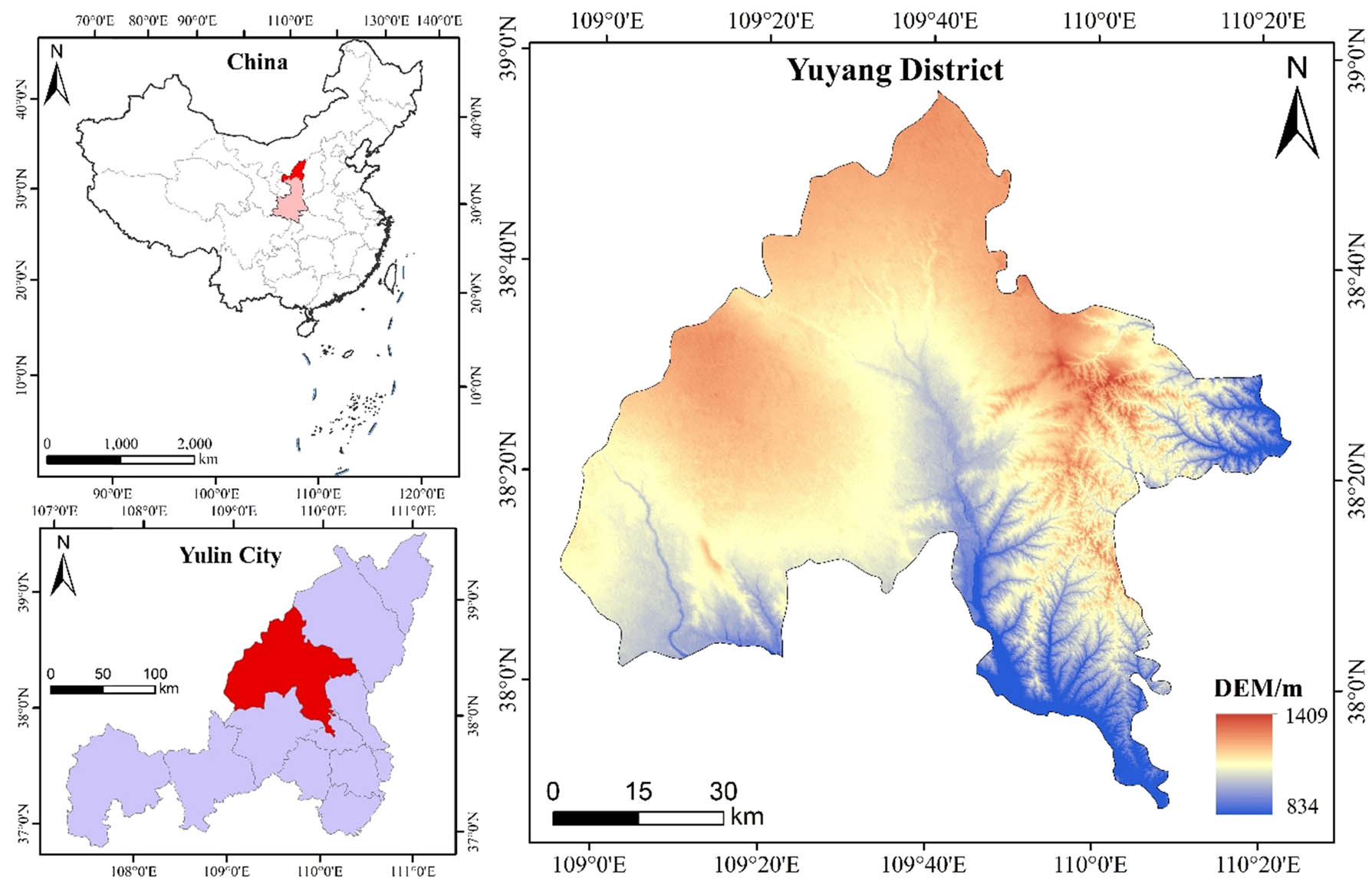
Location and digital elevation map of Yuyang district in Yulin city, China.
2.2 Data sources
The Landsat program of the United States National Aeronautics and Space Administration has launched eight satellites since 23 July, 1972. The data collected by these satellites can be downloaded from the United States Geological Survey website (https://earthexplorer.usgs.gov/). Landsat data are long-term and large-scale ecological environmental monitoring data [20]. The spatial resolution of the Landsat data was 30 m, and they underwent system radiation and geometric correction. The dataset used in the present study was provided by the Geospatial Data Cloud site, Computer Network Information Center, Chinese Academy of Sciences (http://www.gscloud.cn). The present study maximized the accuracy of the surface information of the study area and ensured that image cloud cover was less than 3% by selecting three phases of satellite images with strip numbers (127, 33) and (127, 34) for 18 June, 1993, 16 June, 2004, and 23 June, 2018. Remote sensing images need to be subjected to a series of preprocessing steps before they can be used for quantitative research. The ENVI 5.3 software was used to preprocess the images, including strip repair, image registration, radiometric calibration, atmospheric correction, cloud detection, image mosaic, and cropping. The temperature and rainfall data of Yuyang district were obtained from the China Meteorological Data Network (http://data.cma.cn/). The land use type data were obtained from the Global Geo-information Public Product (http://www.globallandcover.com/).
2.3 Research method
2.3.1 Humidity index
The humidity index indicates the degree of wetness of soil. The present study used the wetness index (WI) of the tassel cap transformation to reveal soil drought variability. The wetness component equation is as follows:
In equation (1), B 1–B 6 represent blue, green, red, near red, mid-infrared 1, and mid-infrared 2 bands, respectively, and c1–c6 are the sensor parameters. The humidity component calculation parameters for the TM and OLI sensors differ due to the different satellite sensor types. In the case of the TM sensor, the values of c1–c6 are 0.0315, 0.2021, 0.3012, 0.1594, −0.6806, and −0.6109, respectively [21], whereas they are 0.1511, 0.1973, 0.3283, 0.3407, −0.7117, and −0.4559, respectively, for the TM sensor [22].
2.3.2 Greenness index
The greenness index is expressed through vegetation indices, among which the remote sensing-based normalized difference vegetation index (NDVI) better reflects the vegetation growth status, vegetation biomass, and other parameters, and is widely used in the study of the spatial and temporal changes of vegetation cover and in the monitoring of crop growth status. Therefore, the present study used NDVI as the greenness index based on the environmental characteristics of the study area. The NDVI can be calculated as follows [23]:
In equation (2),
2.3.3 Dryness index
The dryness index is used to reflect the degree of dryness of the land surface, with both bare land and built-up land increasing land surface “dryness.” The brightness values of the surface types of built-up and bare soil are higher than those of other land types. Therefore, the brightness value of the land surface can act as an indicator of bare surfaces and can represent the spatial distribution of built-up land. The ecological environment is influenced by the spatial distributions of both bare surfaces and built-up land [14]. Therefore, the index-based built-up index (IBI) and the soil index (SI) can be used to construct a normalized differential build-up and bare soil index (NDSI) to represent the dryness of the RSEI. This is calculated as follows [24]:
2.3.4 Heat index
The heat index is reflected through the land surface temperature (LST). As the Landsat TM data only include one thermal infrared band, the present study selected a single-channel algorithm to invert the LST [25]:
In equations (6) and (7),
2.3.5 Construction of the RSEDI
Four remote sensing ecological indicators, namely WI, NDVI, NDSI, and LST, were selected to form a four-dimensional space (Figure 2). Here, the minimum values of WI and NDVI and the maximum values of NDSI and LST represented the least desired ecological environment quality. The distance from all pixel points in the space to the worst point of the ecological environment quality was used as the RSEDI to assess the ecological environment quality in the study area [16]. The value of the RSEDI was proportional to the ecological environment quality.
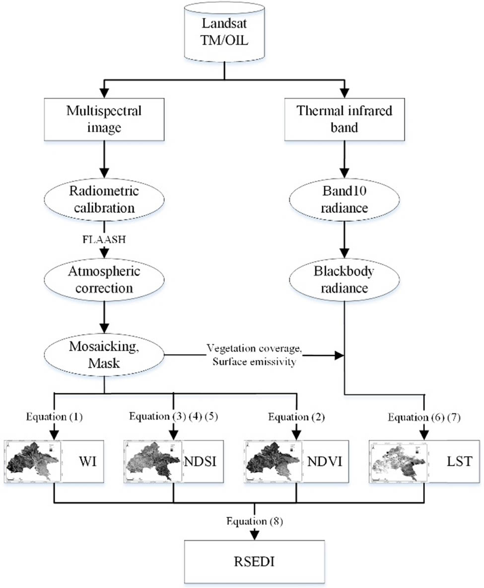
Technique flow chart.
In equation (8),
3 Results
3.1 Overall evaluation of ecological environment quality of Yuyang district
Table 1 shows the mean values of each indicator and RSEDI in Yuyang district of Yulin city for 1993, 2004, and 2018. The trends of each indicator show that the mean LST decreased between 1993 and 2018, indicating a decreasing trend in heat in the study area. However, the rate of decrease during 2004–2018 was significantly lower than that during 1993–2004. Both the NDVI and WI showed increasing trends and larger increases during 1993–2018, indicating that the vegetation cover and soil moisture in Yuyang district have increased. The ecological environment quality of Yuyang district improved significantly from 1993 to 2018, with the mean RSEDI increasing from 0.27 in 1993 to 0.33 in 2004 and further to 0.42 in 2018, an overall increase of 55.03%. Considered together, the ecological environment quality of Yuyang district showed an overall upward trend during the 25 year study period.
Average values of the RSEDI and indicators in Yuyang district, Shaanxi Province, China in 1993, 2004, and 2018
| Year | Index | ||||
|---|---|---|---|---|---|
| LST | NDSI | NDVI | WI | RSEDI | |
| 1993 | 0.85 | 0.52 | 0.18 | 0.27 | 0.27 |
| 2004 | 0.76 | 0.42 | 0.23 | 0.39 | 0.33 |
| 2018 | 0.75 | 0.40 | 0.35 | 0.50 | 0.42 |
3.2 Spatiotemporal distribution of ecological environment quality
The present study graded the RSEDI values according to the equal interval method using an interval of 0.2. The RSEDI values were assigned to five grades from high to low: (1) excellent, (2) good, (3) medium, (4) fair, and (5) poor. Figure 3 shows the spatiotemporal distribution of RSEDI in Yuyang district in 1993, 2004, and 2018, and Table 2 shows the percentages corresponding to each grade. The ecological environment of Yuyang district generally showed a spatial distribution pattern of the ecological environment quality decreasing from the east to the west. Areas with an excellent ecological environment quality in the study area from 1993 to 2018 showed a V-shaped change in the ecological environment quality over time, whereas those with a good ecological environment quality experienced an almost constant ecological environment quality during 1993–2004, following which the ecological environment quality increased dramatically during 2004–2018 from 2.65 to 14.07%. Areas with a medium ecological environment quality showed a continuous upward trend in the ecological environment quality from 10.89% in 1993 to 30.03% in 2018. The regions with fair ecological environment quality showed an inverted V-shaped change in the ecological environment quality. Regions with a poor ecological environment quality showed significant decreasing trends in the ecological environment quality and accounted for 39.63 and 8.03% of the total land area in 1993 and 2018, respectively, a decrease of 31.60%. Overall, the ecological environment quality of Yuyang district from 1993 to 2018 showed an increasing trend, and the proportions of areas with excellent and good grades in the study area continued to increase from 4.30% in 1993 to 16.62% in 2018. The areas with poor and fair ecological environment qualities continued to decrease from 84.81% in 1993 to 53.36% in 2018.
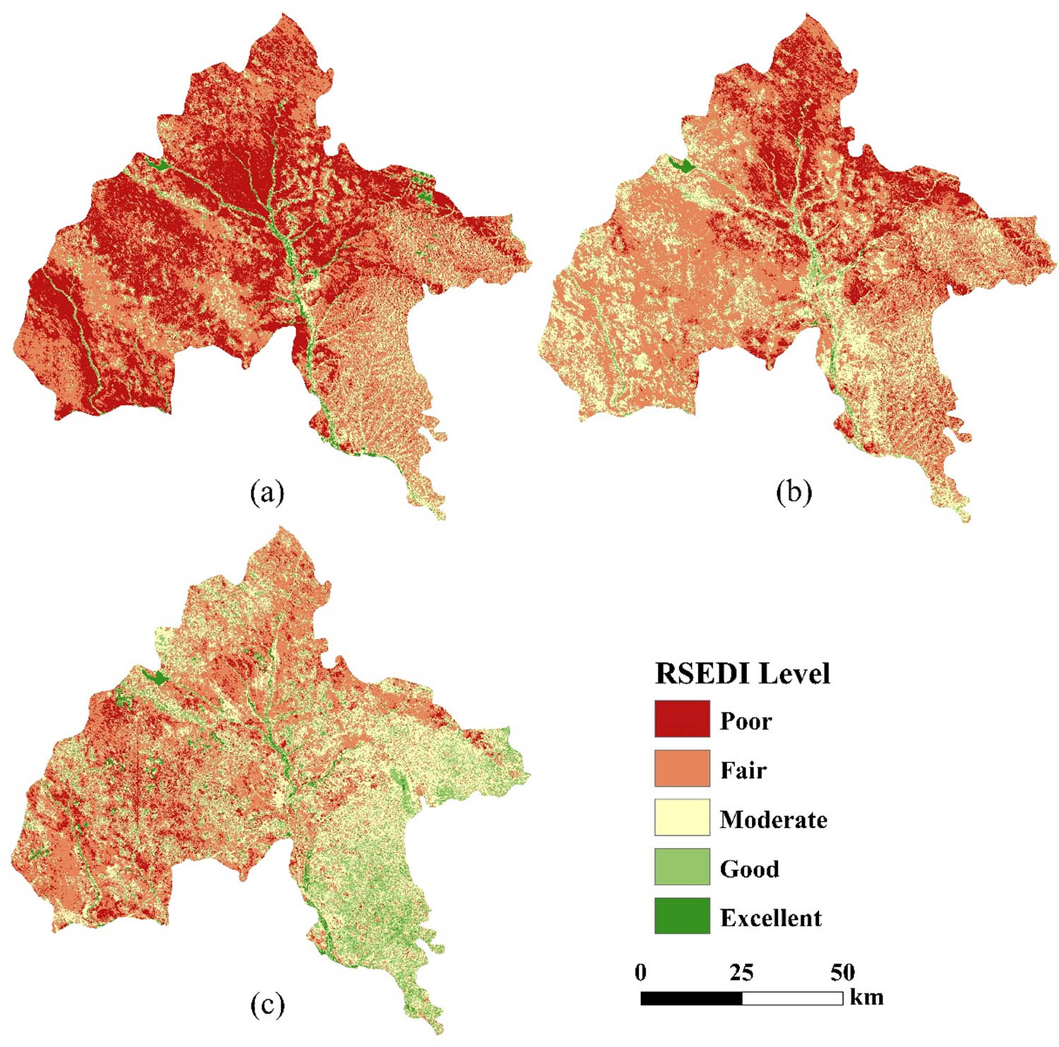
Spatiotemporal distribution of ecological environment quality in Yuyang district, China. (a) 1993, (b) 2004, and (c) 2018.
Proportions of total land area (%) of Yuyang district, Shaanxi Province, China showing different grades of RSEDI from 1993 to 2018
| Level | Grading standards | Percentage | ||
|---|---|---|---|---|
| 1993 | 2004 | 2018 | ||
| Poor | [0.0, 0.2] | 39.63 | 15.93 | 8.03 |
| Fair | (0.2, 0.4] | 45.18 | 57.02 | 45.33 |
| Moderate | (0.4, 0.6] | 10.89 | 23.96 | 30.03 |
| Good | (0.6, 0.8] | 2.79 | 2.65 | 14.07 |
| Excellent | (0.8, 1.0] | 1.51 | 0.44 | 2.55 |
3.3 Spatiotemporal evolution of ecological environment quality
This study used the difference method to detect changes in the RSDEI in Yuyang district in 1993 and 2018 to identify the spatiotemporal changes to the ecological environment quality in Yuyang district from 1993 to 2018. The areas experiencing change were classified into five classes: (1) drastically degraded (≤−2), (2) mildly degraded (−1), (3) largely unchanged (0), (4) mildly improved (1), and (5) drastically improved (≥2). Figure 4 and Table 3 show the areas of the different classes as a proportion of total area. As shown in Table 3, the area of improved ecological environment quality between 1993 and 2018 accounted for 63.81% of Yuyang district. Over the 25 year study period, the ecological environment quality in Yuyang district mainly improved or remained unchanged. Of the total area of Yuyang district, 31.75, 48.29, and 15.52% fell into the largely unchanged, mildly improved, and drastically improved classes, respectively. The area showing a degraded ecological environment quality in Yuyang district was relatively small, accounting for only 4.44% of the total area. As shown in Figure 4, areas showing an improved ecological environment quality in Yuyang district had a scattered distribution. Areas falling into the largely unchanged class showed a scattered distribution in the western part of the study area. Areas showing a degraded ecological environment quality were mainly distributed in urban areas and in the western and northeastern parts, distributed in a strip, point, and block pattern, respectively. The spatiotemporal change in the ecological environment quality in Yuyang district during 1993–2018 generally showed a declining trend in urban areas and an increasing trend in the surrounding areas.
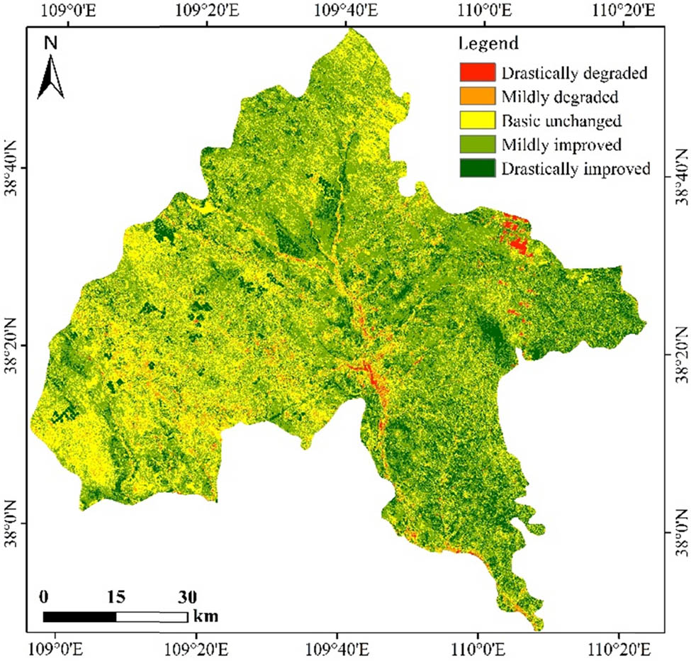
Spatial distribution in changes to ecological environment quality in Yuyang district, Shaanxi Province, China from 1993 to 2018.
Percentage change in RSEDI in Yuyang district, Shaanxi Province, China from 1993 to 2018
| Type | Level | Variation type | Level percent |
|---|---|---|---|
| Degraded | ≤−2 | Drastically degraded | 0.79 |
| −1 | Mildly degraded | 3.65 | |
| Unchanged | 0 | Basic unchanged | 31.75 |
| Improved | 1 | Mildly improved | 48.29 |
| ≥2 | Drastically improved | 15.52 |
3.4 Responsive relationship between ecological environment quality and land use type
Figure 5 shows the spatial distribution of land use types in Yuyang district. Superposition analysis was used to identify the RSEDI of different land use types in Yuyang district in 2018 (Table 4). The results showed that the land use types in Yuyang district are mainly grassland, cropland, and bare land, accounting for 62.56, 19.91, and 12.44% of the area of Yuyang district, respectively, among which grassland was spread all over Yuyang district and cropland and bare land were distributed between grassland in blocks. There was clear variability in the RSEDI among different land use types. Water and wetland were the two land use types with the highest ecological environment quality in the study area, with RSEDI values of 0.91 and 0.70, falling in the excellent and good ecological grades, respectively. Cropland, woodland, and grassland followed with RSEDI values of 0.55, 0.53, and 0.50, respectively, and all falling in the medium ecological grade. Built-up land and bare land showed the lowest RSEDI values of 0.37 and 0.26, respectively.
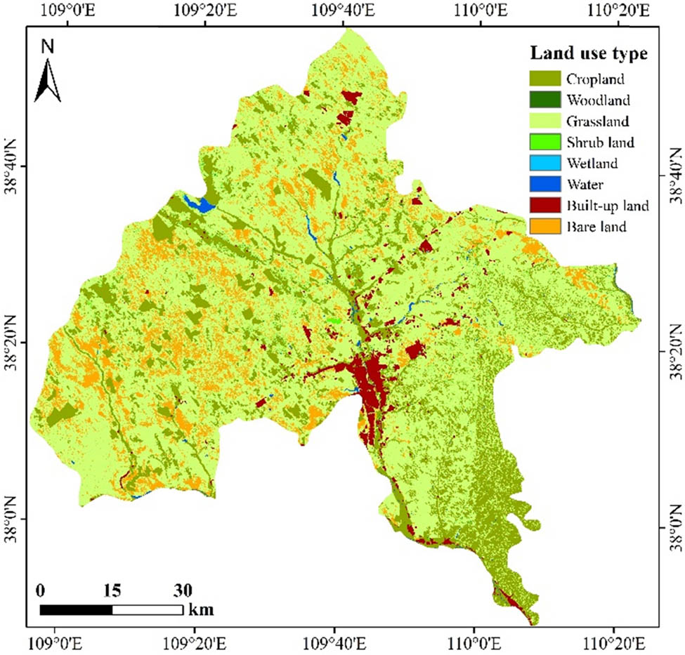
Spatial distribution of land use types in Yuyang district, Shaanxi Province, China.
RSEDI of different land use types in Yuyang district, Shaanxi Province, China in 2018
| Land use type | Area (km2) | Percent | RSEDI | Ecological rating |
|---|---|---|---|---|
| Cropland | 1402.44 | 19.91 | 0.55 | Moderate |
| Woodland | 20.22 | 0.29 | 0.53 | Moderate |
| Grassland | 4406.12 | 62.56 | 0.41 | Moderate |
| Shrub land | 98.50 | 1.40 | 0.50 | Moderate |
| Wetland | 0.69 | 0.01 | 0.70 | Good |
| Water | 32.16 | 0.46 | 0.91 | Excellent |
| Built-up land | 206.68 | 2.93 | 0.37 | Fair |
| Bare land | 875.87 | 12.44 | 0.26 | Fair |
3.5 Responsive relationship between ecological environment quality and hydrothermal conditions
Figure 6 shows the annual rainfall and average annual temperature of Yuyang district from 1991 to 2018. As shown in Figure 5, there was an increasing trend in the average temperature during the study period, with a rate of 0.0434°C/a, indicating a pronounced warming trend in Yuyang district. The study area showing a fluctuating increasing trend in annual rainfall at a rate of 9.213 mm/a, indicating a rising trend in air humidity in Yuyang district from 1991 to 2018.
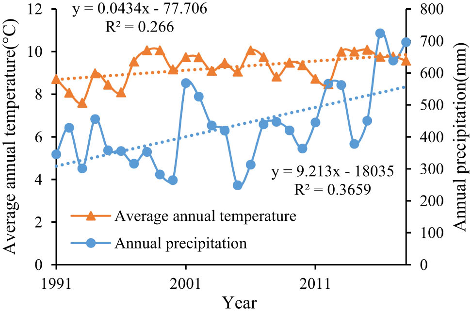
Variations in annual rainfall and temperature in Yuyang district, Shaanxi Province, China from 1991 to 2018.
4 Discussion
The present study exploring the factors influencing the ecological environment quality in Yuyang district. The results showed that climate change is resulting in trends of increasing temperature and rainfall in Yuyang district, consistent with the results of other studies [26,27]. Water and heat conditions are the two most important natural conditions for promoting the vegetation growth and vegetation cover, thereby improving the quality of the local ecological environment. Therefore, water and heat conditions play an important role in the process of improving the ecological environment in Yuyang district. However, significant variability in the trends of the heat and dryness indices, as indicators of temperature and rainfall, respectively, was evident in the study area. The heat and dryness indices continued to decline despite rising temperature and rainfall. This result indicates the existence of other factors contributing to the trends in the heat and dryness indices.
There is an obvious correlation between the ecological environment index and land use types in Yuyang district, with the two factors showing coinciding spatial distributions. This result indicates that the greenness and dryness indices contribute the most to the evaluation of the ecological environment quality, consistent with the findings of Wang and Dai [28]. The effects of changes in land use type on the ecological environment quality can be both positive or negative, with water bodies, wetland, woodland, grassland, and shrubland contributing to an increased ecological environment quality. Therefore, these land use types can be collectively called “ecological land.” An increase in the vegetation cover has a positive effect on the ecological environment quality. Built-up land and bare land decrease the ecological environment quality. These results are consistent with those of Qiu [29].
The “Land-to-Household” policy implemented in China in 1983 greatly encouraged the reclaiming of arable land by local people and ultimately resulted in the areas of cropland and bare land increasing and decreasing, respectively, between 1980 and 1998 [30]. The policy “Taking Farmland Returning to Forest or Grassland” was implemented in 1998. Yuyang district took the lead in implementing the pilot project of “Return Cropland to Woodland,” resulting in 1.11 m mu of other land use types being converted to woodland between 1999 to 2008, including 272,300 mu of cropland, 827,700 mu of bare land suitable for afforestation, and 10,000 mu of mountain area. The area of afforestation and conservation over the entire district reached 4.517 m mu, including 374,000 mu of arbor woodland and 121,000 mu of economic woodland [31]. The area of bare land continued to decrease from 1999 to 2018, thereby explaining the difference between the heat index and dryness index and hydrothermal conditions. The increase in woodland area and the trends of increasing temperature and rainfall explain the increasing greenness and humidity indices. The above analysis confirms that the implementation of ecological projects in China has promoted changes in land use types, thereby improving the ecological environment quality in Yuyang district, Yulin city.
The evaluation of the ecological environment is currently a popular research topic. The dynamic monitoring of the ecological environment based on long-term remote sensing data provides a new platform and perspective for regional ecological environment evaluation [32,33]. The present study used the humidity (WI), dryness (NDSI), greenness (NDVI), and heat (LST) indices to represent ecological environment quality of Yuyang district. The minimum values of the WI and NDVI and the maximum values of sandiness and salinity were taken to represent the least desirable ecological environment quality in the study area to construct the RSEDI. The RSEDI was then used to monitor the ecological environment quality. The results showed an increasing trend in the ecological environment quality of Yuyang district from 1993 to 2018, mainly influenced by the combination of national reforestation, wind and sand control, and other ecological projects and changes in hydrothermal conditions, consistent with the results of existing related studies [34,35,36]. However, the present study only analyzed changes in land use types and hydrothermal conditions relating to changes in the ecological and environmental quality. Other factors contribute to changes to environmental quality, such as population changes and industrial structure. Future research on the ecological and environment quality changes should integrate natural conditions and social and economic factors.
5 Conclusions
The present study constructed the RSEDI by integrating various indicators to enhance its applicability and to simplify the calculation method. The spatiotemporal evolution of the ecological environment quality of Yuyang district from 1993 to 2018 was quantitatively and objectively analyzed. The driving forces behind the spatiotemporal evolution of the ecological environment quality were also described from two perspectives, namely water and heat conditions and ecological policies implemented in China. The result showed that the ecological environment quality in Yuyang district from 1993 to 2018 fell in the fair or moderate categories and showed an improving trend over time. The evolution of the ecological environment quality of Yuyang district is the result of the combined effects of changes in water and heat conditions and implementation of ecological policies in China, with the latter being the dominant driving force. Urbanization had negative impacts on the ecological environment of Yuyang district, whereas the increase in rainfall and implementation of ecological policies had positive impacts on the ecological environment. Therefore, future restoration of the ecological environment of Yuyang district should focus on implementation of ecological policies and further greening of the city. These approaches can increase vegetation coverage and control the speed of expansion and development of built-up area.
Acknowledgments
This study was supported by the Scientific Research Item of Shaanxi Provincial Land Engineering Built-up Group (DJNY2021-33). The authors gratefully acknowledge researchers at the Institute of Land Engineering and Technology, Shaanxi Provincial Land Engineering Construction Group, for their help with the field experiments. The authors thank the editor of this journal and the anonymous reviewers during the revision process.
-
Author contributions: L.Y. managed the entire research project and also analyzed and considered the research materials. L.S. collected and analyzed the meteorological data; J.W. and Y.W. drew the figures for this article; and L.Y. and J.W. reviewed and edited the article. All authors have read and agreed to the published version of the manuscript.
-
Conflict of interest: The authors declare no conflict of interest.
References
[1] Peng J, Wu JS, Pan YJ, Han YN. Evaluation for regional ecological sustainability based on PSR Model: conceptual framework. Prog Geogr. 2012;31(7):933–40.Search in Google Scholar
[2] Yao JQ, Yang Q, Chen YN, Hu WF, Liu ZH, Zhao L. Climate change in arid areas of Northwest China in past 50 years and its effects on the local ecological environment. Chin J Ecol. 2013;32(5):1283–91.Search in Google Scholar
[3] Guo ZC, Wei W, Shi OJ, Zhou L, Wang XF, Li ZY, et al. Spatiotemporal changes of land desertification sensitivity in the arid region of Northwest China. Acta Geogr Sin. 2020;75(9):1948–65.Search in Google Scholar
[4] Liu R, Wang SX, Zhou Y, Yao Y, Han XD. Ecological environment condition evaluation mode of county region based on remote sensing techniques. China Environ Sci. 2012;32(1):181–6.Search in Google Scholar
[5] Yang LY, Cheng J, Li YN. Spatial and temporal variation of NDVI and its response to hydrothermal conditions in northern shaanxi from 2000 to 2018. J Irrig Drain. 2020;39(5):110–8.Search in Google Scholar
[6] Yang LJ, Zhang XH, Pan JH, Yang YC. Coupling coordination and interaction between urbanization and eco-environment in Cheng-Yu urban agglomeration, China. Chin J Appl Ecol. 2021;32(3):993–1004.Search in Google Scholar
[7] Huang DM, Liu XY, Zheng QC, Liu J. Efects of polycentric mode on the coupling and coordinated development between urbanization and ecological environment: a case study of two metropolitan areas in Fujian Province. Acta Ecol Sin. 2020;40(21):7886–96.10.5846/stxb201905291123Search in Google Scholar
[8] Feng YX, Li GD. Interaction between urbanization and eco-environment in Tibetan Plateau. Acta Geogr Sin. 2020;75(7):1386–405.10.1007/s11442-021-1838-8Search in Google Scholar
[9] Yu YH, Zhang WT, Wang JB, Yang S. Prediction of Wuhan urban agglomeration urban heat island and its response to land use. Environ Sci Technol. 2018;41(12):158–68.Search in Google Scholar
[10] Lu HM, Li F, Zhang ML, Yang G, Sun WW. Effects of landscape pattern on annual variation of thermal environment in Hangzhou. Remote Sens Technol Appl. 2018;33(3):398–407.Search in Google Scholar
[11] Ma YG, Tashpolat T, Huang Y, Yang JL. Effects of landscape pattern change on urban heat-island effect in arid areas – a case study in Urumqi. Aridzone Res. 2006;23(1):172–6.Search in Google Scholar
[12] Huang YH, Yan HW, Li XJ, Wu XS, Wang Z. Monitoring and evaluation of remote sensing ecological distance index in Urumqi city. Remote Sens Inf. 2019;34(6):72–7.Search in Google Scholar
[13] Peter C, Schnlze. Overview: measures of enviromental performance and ecosystem condition. Washington DC: National Academy Press; 1999.Search in Google Scholar
[14] Xu HQ. A remote sensing index for assessment of regional ecological changes. China Environ Sci. 2013;33(5):889–97.Search in Google Scholar
[15] Shang LZ, Zhang LS. Quantitative evaluation of ecological vulnerability in gansu counties based on “cause-result” index. Soil Water Conserv China. 2010;2010(6):11–3+23.Search in Google Scholar
[16] Zhang J. The impact of the oasis development on ecological environment – take Guazhou-Dunhuang basin as an example. Lanzhou: Lanzhou University; 2016.Search in Google Scholar
[17] Shi SE, Wei W, Yang D, Hu X, Zhou JJ, Zhang Q. Spatial and temporal evolution of eco-environmental quality in the oasis of Shiyang River Basin based on RSED. Chin J Ecol. 2018;37(4):1152–63.Search in Google Scholar
[18] Zhang CF. Optimization of water resources allocation and harmony of allocation system in Yuyang District of Yulin City considering uncertainty. Yangling: Northwest A&F University; 2017.Search in Google Scholar
[19] Feng JM, Guo LX, Li XH. Analysis of ecological vulnerability in Yuyang District based on landscape pattern. Res Soil Water Conserv. 2016;23(6):179–84.Search in Google Scholar
[20] Nie XR, Hu ZQ, Zhu Q, Ruan MY. Research on temporal and spatial resolution and the driving forces of ecological environment quality in coal mining areas considering topographic correction. Remote Sens. 2021;13:2815.10.3390/rs13142815Search in Google Scholar
[21] Crist EP. A TM tasseled cap equivalent transformation for reflectance factor data. Remote Sens Environ. 1985;17(3):301–6.10.1016/0034-4257(85)90102-6Search in Google Scholar
[22] Baig MH, Zhang L, Shuai T, Tong Q. Derivation of a tasselled cap transformation based on Landsat 8 at-satellite reflectance. Remote Sens Lett. 2014;5(5):423–31.10.1080/2150704X.2014.915434Search in Google Scholar
[23] Gherardo C, Francesca G, Erica M, Saverio F, Davide T, Raffaello P, et al. Monitoring clearcutting and subsequent rapid recovery in Mediterranean coppice forests with Landsat time series. Ann Sci: A J Fr Natl Inst Agric Food Environ (INRAE). 2020;77(1):453–72.10.1007/s13595-020-00936-2Search in Google Scholar
[24] Zha Y, Gao J, Ni S. Use of normalized difference built-up index in automatically mapping urban areas from TM imagery. Int J Remote Sens. 2003;24(3):583–94.10.1080/01431160304987Search in Google Scholar
[25] Xu HQ, Lin ZL, Pan WH. Some issues in land surface temperature retrieval of Landsat thermal data with the single-channel algorithm. Geomat Inf Sci Wuhan Univ. 2015;40(4):487–92.Search in Google Scholar
[26] Chen LX, Zhou XJ, Li WL, Luo YF, Zhu WQ. The characteristics and formation mechanism of climate change in China in the past 80 years. Acta Meteor Sin. 2004;2004(5):634–46.Search in Google Scholar
[27] Liu XQ, Chen YS, Liu YS, Li TS, Lei M, Rui Y, et al. Statistical characteristics of climate change during 1974–2012 in Yulin, Shaanxi, China. J Desert Res. 2017;37(2):355–60.Search in Google Scholar
[28] Wang ZJ, Dai L. Assessment of land use/cover changes and its ecological effect in karst mountainous cities in central Guizhou Province: taking Huaxi District of Guiyang city as a case. Acta Ecol Sin. 2021;41(9):3429–40.10.5846/stxb201909242006Search in Google Scholar
[29] Qiu Q. Study on land use change and its impact on eco-environmental quality of Lin xia zhou. Xi’an: Xi’an University of Science and Technology; 2020.Search in Google Scholar
[30] Bi GH, Yang QY, Zhang JY, Cheng XY. China’s rural land institutional reform in the past 40 years since the reform and opening up and its future directions. China Land Sci. 2018;32(10):1–7.Search in Google Scholar
[31] Dang JJ, Fu SP. Effects of the grain for green project in the development of rural area in the Northern Shannxi Province – a case study in Yuyang District. Res Soil Water Conserv. 2010;17(6):275–77+282.Search in Google Scholar
[32] Li X, Zhang H, Yu J, Gong Y, Guan X, Li S. Spatial–temporal analysis of urban ecological comfort index derived from remote sensing data: a case study of Hefei, China. J Appl Remote Sens. 2021;15(4):042403.10.1117/1.JRS.15.042403Search in Google Scholar
[33] Wang J, Liu DW, Jiali M, Cheng YN, Wang LX. Development of a large-scale remote sensing ecological index in arid areas and its application in the Aral Sea Basin. J Arid Land. 2021;13(1):40–55.10.1007/s40333-021-0052-ySearch in Google Scholar
[34] Sun CJ, Zhang WQ, Li XG, Sun JL. Evaluation of ecological effect of gully region of loess plateau based on remote sensing image. Trans Chin Soc Agric Eng. 2019;35(12):165–72.10.3390/su12083489Search in Google Scholar
[35] Ma F, Zhuo J, He HJ, Han SS. Ecological evolution and driving mechanism of vegetation in Yulin City. Shaanxi Province Bull Soil Water Conserv. 2020;40(5):257–61.Search in Google Scholar
[36] Wang ZY, Chen XY, Ma CS. Changes of soil erosion and ecological service value before and after implementing the project of returning farmland to forest in Yulin of Northern Shaanxi. J Northwest Fores Univ. 2021;36(3):59–67.Search in Google Scholar
© 2021 Liangyan Yang et al., published by De Gruyter
This work is licensed under the Creative Commons Attribution 4.0 International License.
Articles in the same Issue
- Regular Articles
- Lithopetrographic and geochemical features of the Saalian tills in the Szczerców outcrop (Poland) in various deformation settings
- Spatiotemporal change of land use for deceased in Beijing since the mid-twentieth century
- Geomorphological immaturity as a factor conditioning the dynamics of channel processes in Rządza River
- Modeling of dense well block point bar architecture based on geological vector information: A case study of the third member of Quantou Formation in Songliao Basin
- Predicting the gas resource potential in reservoir C-sand interval of Lower Goru Formation, Middle Indus Basin, Pakistan
- Study on the viscoelastic–viscoplastic model of layered siltstone using creep test and RBF neural network
- Assessment of Chlorophyll-a concentration from Sentinel-3 satellite images at the Mediterranean Sea using CMEMS open source in situ data
- Spatiotemporal evolution of single sandbodies controlled by allocyclicity and autocyclicity in the shallow-water braided river delta front of an open lacustrine basin
- Research and application of seismic porosity inversion method for carbonate reservoir based on Gassmann’s equation
- Impulse noise treatment in magnetotelluric inversion
- Application of multivariate regression on magnetic data to determine further drilling site for iron exploration
- Comparative application of photogrammetry, handmapping and android smartphone for geotechnical mapping and slope stability analysis
- Geochemistry of the black rock series of lower Cambrian Qiongzhusi Formation, SW Yangtze Block, China: Reconstruction of sedimentary and tectonic environments
- The timing of Barleik Formation and its implication for the Devonian tectonic evolution of Western Junggar, NW China
- Risk assessment of geological disasters in Nyingchi, Tibet
- Effect of microbial combination with organic fertilizer on Elymus dahuricus
- An OGC web service geospatial data semantic similarity model for improving geospatial service discovery
- Subsurface structure investigation of the United Arab Emirates using gravity data
- Shallow geophysical and hydrological investigations to identify groundwater contamination in Wadi Bani Malik dam area Jeddah, Saudi Arabia
- Consideration of hyperspectral data in intraspecific variation (spectrotaxonomy) in Prosopis juliflora (Sw.) DC, Saudi Arabia
- Characteristics and evaluation of the Upper Paleozoic source rocks in the Southern North China Basin
- Geospatial assessment of wetland soils for rice production in Ajibode using geospatial techniques
- Input/output inconsistencies of daily evapotranspiration conducted empirically using remote sensing data in arid environments
- Geotechnical profiling of a surface mine waste dump using 2D Wenner–Schlumberger configuration
- Forest cover assessment using remote-sensing techniques in Crete Island, Greece
- Stability of an abandoned siderite mine: A case study in northern Spain
- Assessment of the SWAT model in simulating watersheds in arid regions: Case study of the Yarmouk River Basin (Jordan)
- The spatial distribution characteristics of Nb–Ta of mafic rocks in subduction zones
- Comparison of hydrological model ensemble forecasting based on multiple members and ensemble methods
- Extraction of fractional vegetation cover in arid desert area based on Chinese GF-6 satellite
- Detection and modeling of soil salinity variations in arid lands using remote sensing data
- Monitoring and simulating the distribution of phytoplankton in constructed wetlands based on SPOT 6 images
- Is there an equality in the spatial distribution of urban vitality: A case study of Wuhan in China
- Considering the geological significance in data preprocessing and improving the prediction accuracy of hot springs by deep learning
- Comparing LiDAR and SfM digital surface models for three land cover types
- East Asian monsoon during the past 10,000 years recorded by grain size of Yangtze River delta
- Influence of diagenetic features on petrophysical properties of fine-grained rocks of Oligocene strata in the Lower Indus Basin, Pakistan
- Impact of wall movements on the location of passive Earth thrust
- Ecological risk assessment of toxic metal pollution in the industrial zone on the northern slope of the East Tianshan Mountains in Xinjiang, NW China
- Seasonal color matching method of ornamental plants in urban landscape construction
- Influence of interbedded rock association and fracture characteristics on gas accumulation in the lower Silurian Shiniulan formation, Northern Guizhou Province
- Spatiotemporal variation in groundwater level within the Manas River Basin, Northwest China: Relative impacts of natural and human factors
- GIS and geographical analysis of the main harbors in the world
- Laboratory test and numerical simulation of composite geomembrane leakage in plain reservoir
- Structural deformation characteristics of the Lower Yangtze area in South China and its structural physical simulation experiments
- Analysis on vegetation cover changes and the driving factors in the mid-lower reaches of Hanjiang River Basin between 2001 and 2015
- Extraction of road boundary from MLS data using laser scanner ground trajectory
- Research on the improvement of single tree segmentation algorithm based on airborne LiDAR point cloud
- Research on the conservation and sustainable development strategies of modern historical heritage in the Dabie Mountains based on GIS
- Cenozoic paleostress field of tectonic evolution in Qaidam Basin, northern Tibet
- Sedimentary facies, stratigraphy, and depositional environments of the Ecca Group, Karoo Supergroup in the Eastern Cape Province of South Africa
- Water deep mapping from HJ-1B satellite data by a deep network model in the sea area of Pearl River Estuary, China
- Identifying the density of grassland fire points with kernel density estimation based on spatial distribution characteristics
- A machine learning-driven stochastic simulation of underground sulfide distribution with multiple constraints
- Origin of the low-medium temperature hot springs around Nanjing, China
- LCBRG: A lane-level road cluster mining algorithm with bidirectional region growing
- Constructing 3D geological models based on large-scale geological maps
- Crops planting structure and karst rocky desertification analysis by Sentinel-1 data
- Physical, geochemical, and clay mineralogical properties of unstable soil slopes in the Cameron Highlands
- Estimation of total groundwater reserves and delineation of weathered/fault zones for aquifer potential: A case study from the Federal District of Brazil
- Characteristic and paleoenvironment significance of microbially induced sedimentary structures (MISS) in terrestrial facies across P-T boundary in Western Henan Province, North China
- Experimental study on the behavior of MSE wall having full-height rigid facing and segmental panel-type wall facing
- Prediction of total landslide volume in watershed scale under rainfall events using a probability model
- Toward rainfall prediction by machine learning in Perfume River Basin, Thua Thien Hue Province, Vietnam
- A PLSR model to predict soil salinity using Sentinel-2 MSI data
- Compressive strength and thermal properties of sand–bentonite mixture
- Age of the lower Cambrian Vanadium deposit, East Guizhou, South China: Evidences from age of tuff and carbon isotope analysis along the Bagong section
- Identification and logging evaluation of poor reservoirs in X Oilfield
- Geothermal resource potential assessment of Erdaobaihe, Changbaishan volcanic field: Constraints from geophysics
- Geochemical and petrographic characteristics of sediments along the transboundary (Kenya–Tanzania) Umba River as indicators of provenance and weathering
- Production of a homogeneous seismic catalog based on machine learning for northeast Egypt
- Analysis of transport path and source distribution of winter air pollution in Shenyang
- Triaxial creep tests of glacitectonically disturbed stiff clay – structural, strength, and slope stability aspects
- Effect of groundwater fluctuation, construction, and retaining system on slope stability of Avas Hill in Hungary
- Spatial modeling of ground subsidence susceptibility along Al-Shamal train pathway in Saudi Arabia
- Pore throat characteristics of tight reservoirs by a combined mercury method: A case study of the member 2 of Xujiahe Formation in Yingshan gasfield, North Sichuan Basin
- Geochemistry of the mudrocks and sandstones from the Bredasdorp Basin, offshore South Africa: Implications for tectonic provenance and paleoweathering
- Apriori association rule and K-means clustering algorithms for interpretation of pre-event landslide areas and landslide inventory mapping
- Lithology classification of volcanic rocks based on conventional logging data of machine learning: A case study of the eastern depression of Liaohe oil field
- Sequence stratigraphy and coal accumulation model of the Taiyuan Formation in the Tashan Mine, Datong Basin, China
- Influence of thick soft superficial layers of seabed on ground motion and its treatment suggestions for site response analysis
- Monitoring the spatiotemporal dynamics of surface water body of the Xiaolangdi Reservoir using Landsat-5/7/8 imagery and Google Earth Engine
- Research on the traditional zoning, evolution, and integrated conservation of village cultural landscapes based on “production-living-ecology spaces” – A case study of villages in Meicheng, Guangdong, China
- A prediction method for water enrichment in aquifer based on GIS and coupled AHP–entropy model
- Earthflow reactivation assessment by multichannel analysis of surface waves and electrical resistivity tomography: A case study
- Geologic structures associated with gold mineralization in the Kirk Range area in Southern Malawi
- Research on the impact of expressway on its peripheral land use in Hunan Province, China
- Concentrations of heavy metals in PM2.5 and health risk assessment around Chinese New Year in Dalian, China
- Origin of carbonate cements in deep sandstone reservoirs and its significance for hydrocarbon indication: A case of Shahejie Formation in Dongying Sag
- Coupling the K-nearest neighbors and locally weighted linear regression with ensemble Kalman filter for data-driven data assimilation
- Multihazard susceptibility assessment: A case study – Municipality of Štrpce (Southern Serbia)
- A full-view scenario model for urban waterlogging response in a big data environment
- Elemental geochemistry of the Middle Jurassic shales in the northern Qaidam Basin, northwestern China: Constraints for tectonics and paleoclimate
- Geometric similarity of the twin collapsed glaciers in the west Tibet
- Improved gas sand facies classification and enhanced reservoir description based on calibrated rock physics modelling: A case study
- Utilization of dolerite waste powder for improving geotechnical parameters of compacted clay soil
- Geochemical characterization of the source rock intervals, Beni-Suef Basin, West Nile Valley, Egypt
- Satellite-based evaluation of temporal change in cultivated land in Southern Punjab (Multan region) through dynamics of vegetation and land surface temperature
- Ground motion of the Ms7.0 Jiuzhaigou earthquake
- Shale types and sedimentary environments of the Upper Ordovician Wufeng Formation-Member 1 of the Lower Silurian Longmaxi Formation in western Hubei Province, China
- An era of Sentinels in flood management: Potential of Sentinel-1, -2, and -3 satellites for effective flood management
- Water quality assessment and spatial–temporal variation analysis in Erhai lake, southwest China
- Dynamic analysis of particulate pollution in haze in Harbin city, Northeast China
- Comparison of statistical and analytical hierarchy process methods on flood susceptibility mapping: In a case study of the Lake Tana sub-basin in northwestern Ethiopia
- Performance comparison of the wavenumber and spatial domain techniques for mapping basement reliefs from gravity data
- Spatiotemporal evolution of ecological environment quality in arid areas based on the remote sensing ecological distance index: A case study of Yuyang district in Yulin city, China
- Petrogenesis and tectonic significance of the Mengjiaping beschtauite in the southern Taihang mountains
- Review Articles
- The significance of scanning electron microscopy (SEM) analysis on the microstructure of improved clay: An overview
- A review of some nonexplosive alternative methods to conventional rock blasting
- Retrieval of digital elevation models from Sentinel-1 radar data – open applications, techniques, and limitations
- A review of genetic classification and characteristics of soil cracks
- Potential CO2 forcing and Asian summer monsoon precipitation trends during the last 2,000 years
- Erratum
- Erratum to “Calibration of the depth invariant algorithm to monitor the tidal action of Rabigh City at the Red Sea Coast, Saudi Arabia”
- Rapid Communication
- Individual tree detection using UAV-lidar and UAV-SfM data: A tutorial for beginners
- Technical Note
- Construction and application of the 3D geo-hazard monitoring and early warning platform
- Enhancing the success of new dams implantation under semi-arid climate, based on a multicriteria analysis approach: Case of Marrakech region (Central Morocco)
- TRANSFORMATION OF TRADITIONAL CULTURAL LANDSCAPES - Koper 2019
- The “changing actor” and the transformation of landscapes