Research on the impact of expressway on its peripheral land use in Hunan Province, China
-
Li Zhixue


Abstract
The purpose of this research is to study the scope and magnitude of the impact of expressways and their entrances and exits, as well as the effects of environmental and socio-economic factors on those impacts. Based on multi-period remote-sensing images and land use/land cover change data, the expressway lines and entrances and exits in Hunan Province, China, in 2015 are selected as the research objects. The Urbanization Impact Index (U) and the Impact Strength Index (E) are used to characterize the impact of the expressway on peripheral land use. Geographic information system spatial analysis and correlation analysis methods are also used in this research. The results show that (1) the scope of the expressway impact is 8.4 km and that of the entrances and exits is 8.8 km, of which the impact is considered strong within 0.2 and 3.2 km, respectively; (2) environmental and socio-economic conditions have no obvious effect on the impact scope of the expressways but have a weak effect on the impact scope of the entrances and exits; and (3) regions with more complex terrain and a lower level of socio-economic development have the larger impact scope as well as a stronger impact.
1 Introduction
In road ecology, the impact of roads on land use is defined as the road effect zone, which includes distance, pattern, morphology, impact categories, and impact degree [1,2] Among these, the spatial orientation and impact degree are research hotspots, and the purpose is to analyze the scope and magnitude of the impact of the road on the surrounding land use. The current studies on the impact of roads on surrounding land use often have a single result, and most of them do not consider the differences in the natural and socio-economic conditions of the areas through which the roads pass. These differences in impact due to different natural and socio-economic conditions can be confirmed by the inconsistent research conclusions of different current studies, and such inconsistency not only manifests in differences of impact scope [3,4,5,6,7,8] but also in variations of strength within the impact scope [9,10,11]. Therefore, this study selected an area with a relatively large spatial scope, in which there are obvious differences in natural and socio-economic conditions. Studying the differences in road impacts under different conditions is one of the scientific values of this study. In addition, current studies usually take the road as a whole and lack discussion on the impact relative to different parts of the road (such as expressway routes and entrances and exits). It is necessary to study the impact of different parts of the road on the surrounding land use and analyze their differences.
An expressway is a typical road type. The construction of an expressway has a significant impact on its peripheral land use/land cover change (LUCC) [12,13,14], and LUCCs will have an impact on ecosystem services [15]; however, due to differences in how different parts of the expressway are accessed (such as the closed management of the roadway and the relatively open management of entrances and exits), this impact varies. This study took an expressway in Hunan Province, China, as an example to investigate the impact of roadways and entrances and exits on the peripheral land use, and the differences under different environmental and socio-economic conditions, to provide a research case for future projects and research.
Hunan Province is located in the middle of China, with geographic coordinates of 108°47′E–114°15′E, 24°38′N–30°08′N and a total area of 21.18 million square kilometers. Hunan is located in the transitional area between the Yungui Plateau to the Jiangnan Hills and the Nanling Mountains to the Jianghan Plain. The geography creates a horseshoe shape with mountains on three sides and an opening to the north. The geomorphic types include semi-alpine, low mountain, hill region, downland, basin, and plain. The Xiangjiang, Zijiang, Yuanjiang, and Lishui Rivers flow into Dongting Lake from south to north along the geography. The gross domestic product (GDP) of Hunan Province in 2015 was 28902.21 billion yuan, while in 2020 it grew to 41781.49 billion yuan; the permanent population was 69.1838 million, and the urbanization rate was 57.22%, ranking 22nd in China. The social and economic development of Hunan is unbalanced, and the northern and central regions are notably more developed than the western and southern regions. The expressway construction in Hunan started late, but it is developing rapidly. By 2020, the expressway traffic mileage within Hunan reached 6,820 km, ranking 4th in China.
The expressway data in this study were obtained through visual interpretation of Map World remote sensing (RS) images. Thirty-six expressway lines were analyzed along a total distance of 5,798 km and with 390 entrances and exits that were counted as a pair (Figure 1). The line data obtained through interpretation were linear elements, whereas the entrance and exit data were point elements. To fit the actual situation, the linear and point elements were analyzed with a buffer to form polygonal elements. The buffer radius of the lines and the entrances and exits was set to 50 and 75 m, respectively. The LUCC data in this study come from the Resource and Environment Science Data Center of the Chinese Academy of Sciences (https://www.resdc.cn/), obtained through interpretation of Landsat RS images with a resolution of 30 m, with high data accuracy [16]. To better define the macro-characteristics of the impact, the land use was classified into six types according to the first-class classification standard of LUCC classification system in China: cultivated land, woodland, grassland, waters, construction land, and unutilized land (land that is currently unused or difficult to use, including Sand, Gobi area, Saline-Alkali Land, Moorland, Bare Land, and Bare Rock). The topographic data were obtained from the 1:250,000 topography, and the GDP, population, urbanization rate, etc. were obtained from the statistical yearbook [17]. The timeline for all data was 2015.
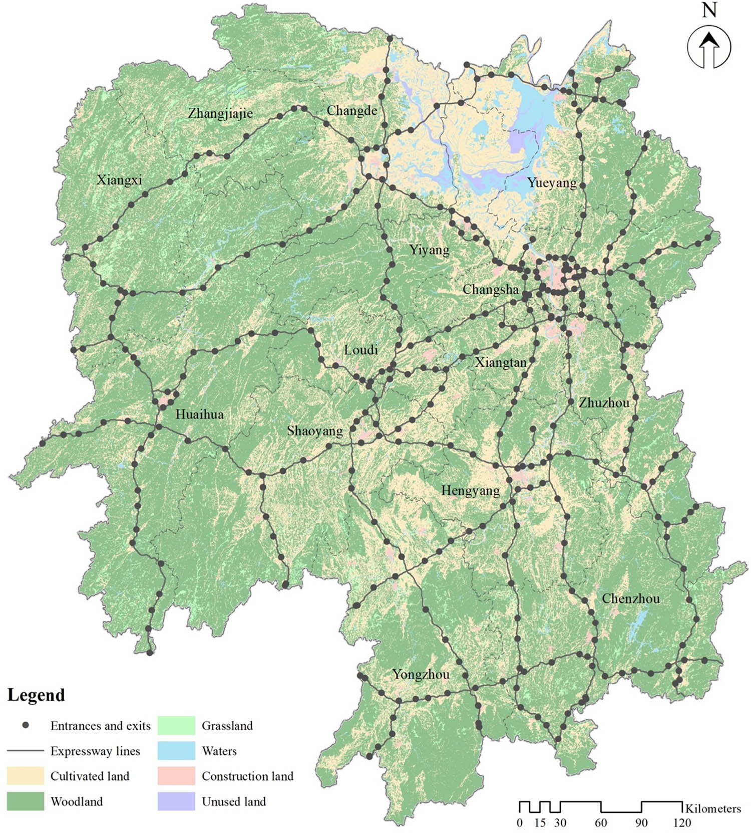
Research area and data from 2015.
2 Research method
2.1 Application of spatial information technology
Geographic information system (GIS) and RS are the most commonly used technical means to study land use patterns and their changes [18,19], and they are also widely used in road ecology [20,21]. In this study, RS was used to obtain the basic expressway and LUCC data; a buffer analysis of GIS data was used to form the impact area of the expressway; overlay analysis of GIS data was used to superpose the impact area and LUCC data on the area map, and spatial statistical analysis of GIS data was used to develop relevant data and related parameters. Data processing and spatial analyses were completed in ArcGIS 10.2, and the tools used included Buffer, Multiple Ring Buffer, Intersect, Summary Statistics, and Zonal Statistics as Table.
2.2 Factor selection and calculation
To analyze the differences in the impact area of an expressway in different environmental and socio-economic conditions (as well as the differences in the impact strength within the impact scope), mean altitude, mean slope, GDP per unit area, population density, and urbanization rate were selected as evaluation factors. The spatial unit for the calculation of statistics for all factors is the city. To calculate the mean altitude and the mean slope of the city, the city was classified as a grid with individual cells of 200 m × 200 m. The formulas for calculating the factors of mean altitude and mean slope are as follows:
M e and M s are the mean altitude and mean slope, respectively, in the region of a city; e n and s n are the altitude and slope, respectively, of the nth cell of a city, and n is the total number of cells in the region of a city.
The formulas for GDP per unit area and population density are as follows:
D GDP and D p are the GDP per unit area and population density, respectively, in a city; T GDP and T p are the total GDP and population, respectively, in the region of a city, and S is the area of the target region.
2.3 Calculation of urbanization impact index
First, multi-ring buffer analysis was carried out for expressway lines and entrances and exits. According to relevant conclusions from previous research, the radius of the buffer rings was set to 200 m and the number of buffer rings was set to 50, which exceeded the impact scope of 8 km obtained in existing research [7,8]. The buffer results were superposed on LUCC data, and then the area of each type of land use was calculated. To analyze the degree of the impact of the expressway on land use, the urbanization impact index U proposed by Hall and Tian [22] and Liu and Cui [23] was used as a quantitative index. The formula for U is as follows:
A p is the area of the built environment in a buffer ring, and A n is the remaining area of other land types. In this study, n was set to 5, representing cultivated land, woodland, grassland, waters, and unutilized land. The calculation of U included buffer rings covering provincial and municipal regions of a city.
A buffer ring was determined to be part of the expressway impact scope if the value of U was higher than the regional mean value of U, and the area was determined to be strongly impacted by the expressway when the value of U was three times the regional mean value of U.
2.4 Calculation of impact strength
After determining the impact scope of expressways, to analyze the relative impact strength within the impact scope on the peripheral land use, the index E was used as a quantitative index. The formula for E is as follows:
E is the impact strength; U a is the urbanization impact index calculated for a buffer ring within the municipal region using equation 5, and U r is the mean urbanization impact index in the region of a city. The greater the value of E was, the greater was the relative impact strength of an expressway on peripheral land use.
2.5 Calculation of correlation coefficient
Taking 14 cities of Hunan as samples, the Pearson correlation coefficients of each factor with the impact scope and impact strength were calculated using the statistical package for social sciences. It is generally believed that parties are highly correlated when |r| ≥ 0.7 (P < 0.01), moderately correlated when 0.3 < |r| < 0.7 (P < 0.05), and poorly correlated or uncorrelated when |r| ≤ 0.3 (P > 0.05) [24].
3 Results
3.1 Impact scope and correlation
U values of expressways in Hunan Province, which are shown in Figure 2, and all cities were calculated. Within 5 km, the U value of the entrances and exits was higher than that of the expressway line, and beyond 5 km, the U values of the two were basically the same. Within 3.2 km, the U value of the entrances and exits was larger for all buffer rings; whereas beyond 8.8 km, it was smaller than the mean U value for Hunan Province. The U value of the line itself was larger than its average value within 0.2 km, decreased rapidly beyond 0.2 km, and tended to become stable. Beyond 8.4 km, the U value fell below the mean value for Hunan Province. The U value of the expressway buffer rings and the mean U value of the municipal region of the city were calculated. According to the classification of the U value, the expressway impact scope on Hunan Province and each city was determined (Table 1).
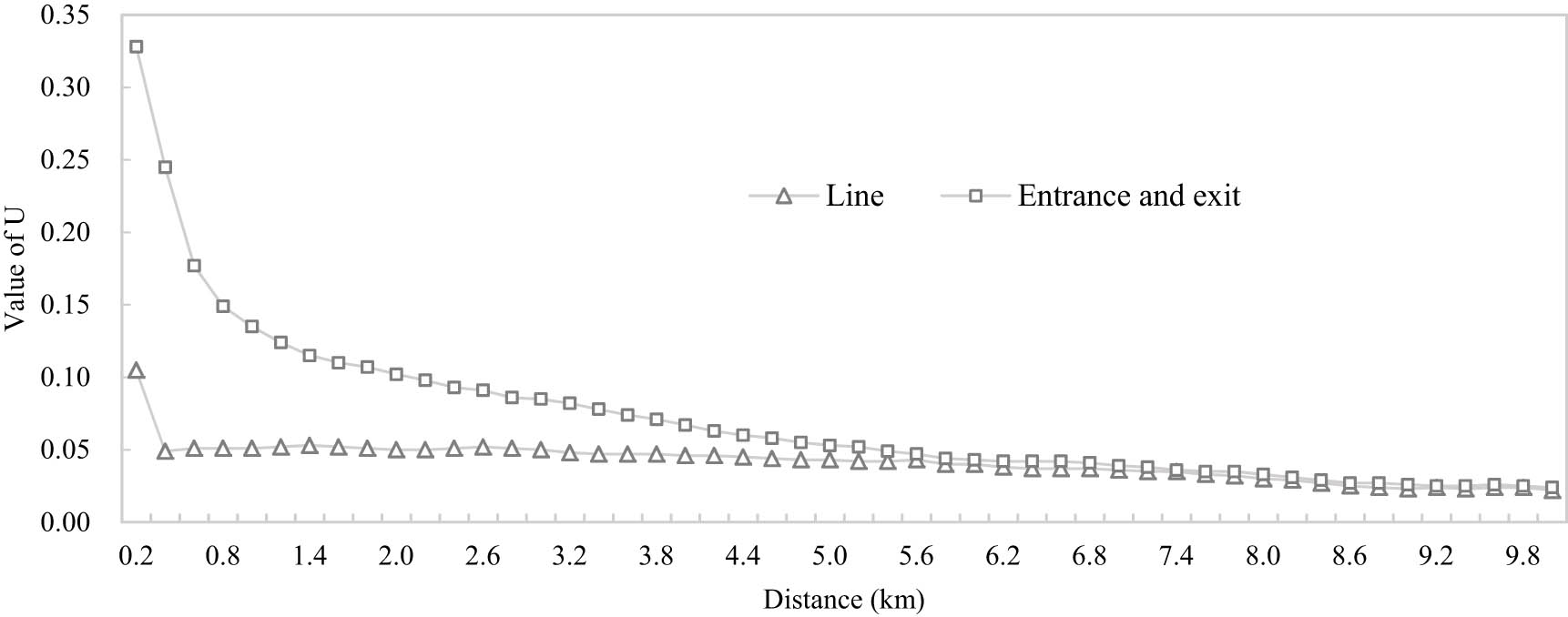
Changes of U value in 10 km buffer ring of expressways in Hunan Province.
The impact scope of expressway in Hunan Province and each city
| Cities | Strong impact scope of lines (km) | Impact scope of lines (km) | Strong impact scope of entrances and exits (km) | Impact scope of entrances and exits (km) |
|---|---|---|---|---|
| Hunan | 0.2 | 8.4 | 3.2 | 8.8 |
| Changsha | 0.0 | 6.8 | 2.0 | 5.8 |
| Zhuzhou | 0.0 | 8.6 | 0.8 | 8.6 |
| Xiangtan | 0.0 | 9.6 | 1.5 | 6.8 |
| Hengyang | 0.2 | 8.2 | 1.2 | 8.4 |
| Shaoyang | 0.2 | 7.8 | 4.4 | 9.0 |
| Yueyang | 0.0 | 7.0 | 2.6 | 7.6 |
| Changde | 0.2 | 9.8 | 1.2 | 9.6 |
| Zhangjiajie | 3.8 | 6.0 | 4.2 | 8.6 |
| Yiyang | 0.2 | 5.4 | 4.0 | 5.8 |
| Chenzhou | 0.2 | 7.6 | 1.4 | 8.0 |
| Yongzhou | 0.2 | 12.0 | 0.4 | 11.6 |
| Huaihua | 0.2 | 5.2 | 5.0 | 7.4 |
| Loudi | 0.0 | 11.8 | 1.0 | 11.4 |
| Xiangxi | 0.2 | 6.0 | 3.4 | 7.2 |
The correlation coefficient of the strong impact of the lines was not calculated because the scope values were zero and relatively flat. The correlation coefficients of other parts and each factor are shown in Figure 3. The impact of the lines was not related to each factor. The impact scope of entrances and exits was moderately positively correlated with mean altitude, moderately negatively correlated with GDP per unit area and urbanization rate, and was not correlated with other factors. The strong impact scope of entrances and exits was moderately correlated with all factors; it was positively correlated with topographic factors and negatively correlated with socio-economic factors.
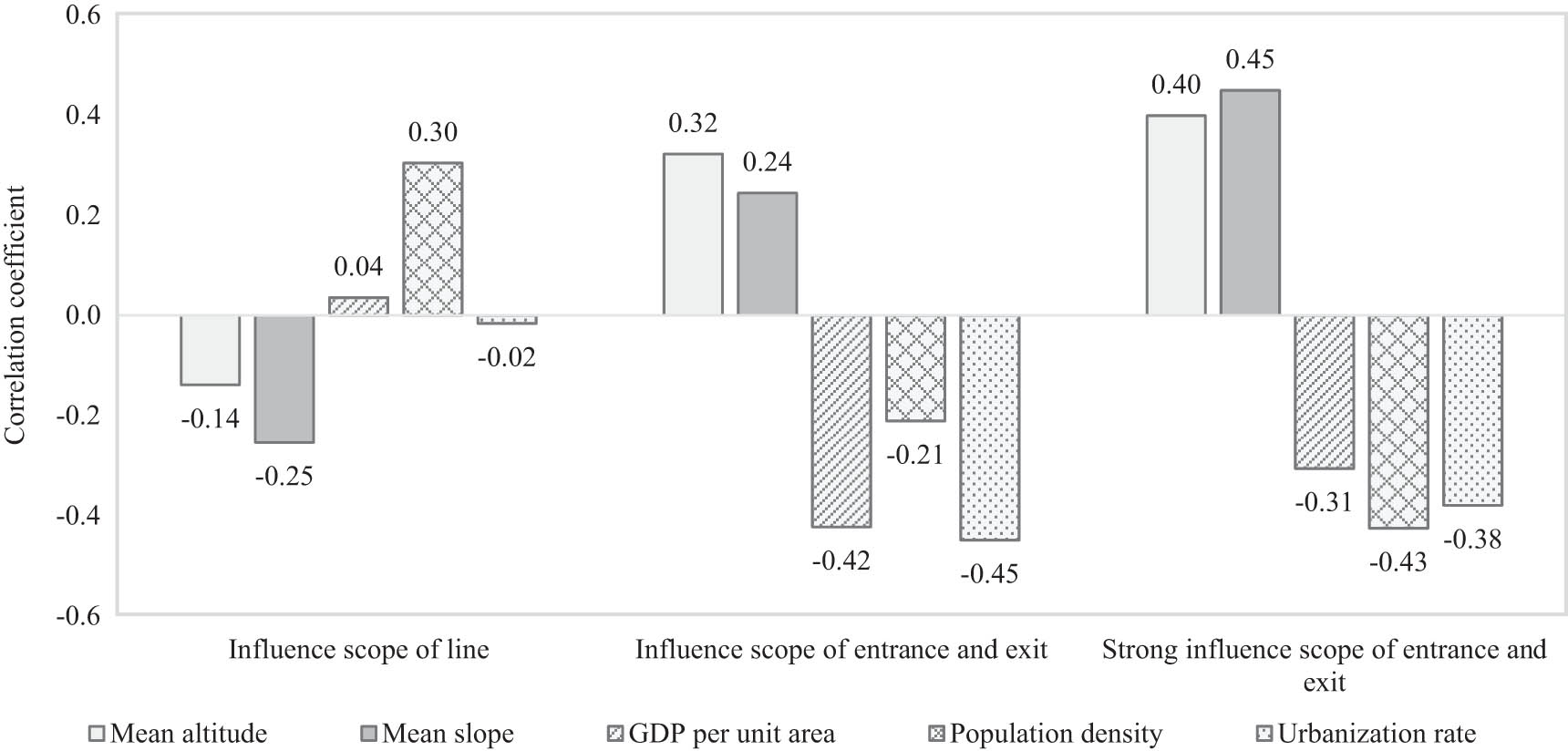
The correlation coefficient between the impact scope of expressway and each factor.
3.2 Impact strength and correlation
The correlation coefficient between the impact strength and each factor within the impact scope of the expressway is shown in Figure 4. The impact strength of lines and entrances and exits was positively correlated with topographic factors and negatively correlated with socio-economic factors. The line was highly correlated with the mean slope and moderately correlated with other factors. Entrances and exits were moderately correlated with all factors.
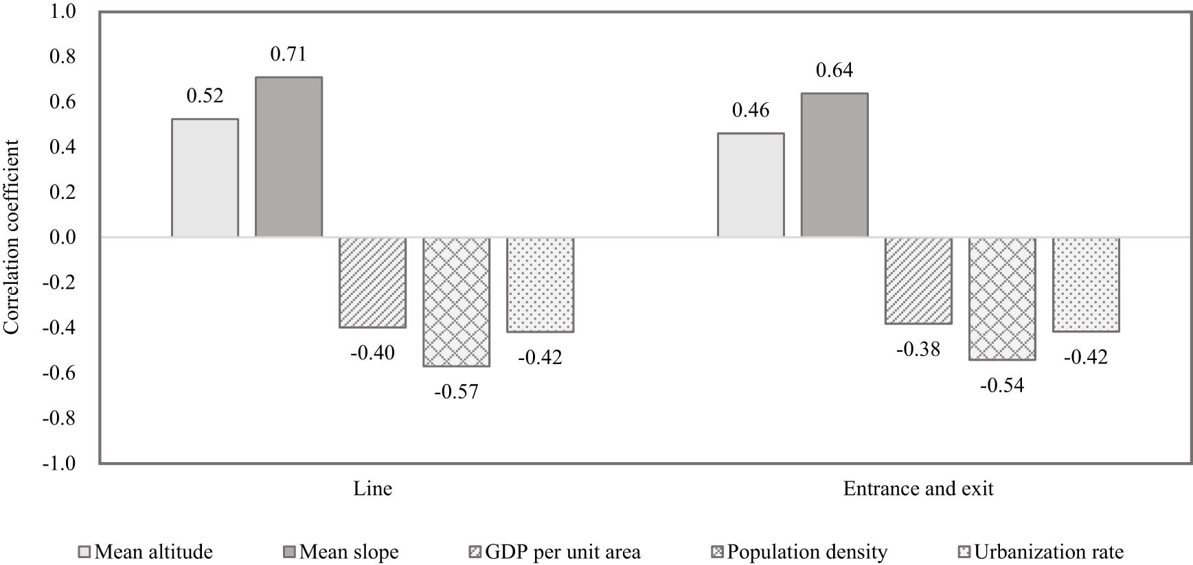
The correlation coefficient between impact strength and factors.
4 Discussion
4.1 Impact scope
Current studies by scholars show that the impact scope of an expressway on peripheral land use is approximately 8 km [7,8], but these studies have not considered the variations in impact scope related to different components of the expressway. According to the calculated impact strength and its classification in this study, the impact scope of lines and entrances and exits in Hunan was 8.4 and 8.8 km, respectively, within which the impact scope was considered strong for 0.2 and 3.2 km, respectively. Generally, there was little difference in impact scope between the lines and entrances and exits, but the impact scope strength of lines was significantly larger than the entrances and exits, which was mainly due to the accessibility of the two. The line was completely closed and had little contact with the peripheral land, so it was difficult to directly change the peripheral land-use type. Construction that did occur was limited to close proximity to the expressway. In contrast, the expressway affected the land in a relatively distant location through the nearby entrances and exits. Entrances and exits are expressway access. On the one hand, the construction of entrances and exits dramatically increased the flow of people and logistics around them; on the other hand, the advantages of convenient external transportation and lower transportation cost increased around them. As a result, the peripheral cultivated land, woodland, and waters were transformed into commercial, industrial, and residential land [14,25].
The impact of the expressway line on the peripheral land use was small, so the regional topography and socio-economic conditions did not experience a positive or negative effect from the impact scope of the line. The strong impact scope of entrances and exits is positively related to the topographic conditions. The more complex the topographic conditions, the larger the influence scope, and vice versa. This is related to the suitability of urban construction. In areas with complex topographic conditions, the suitability of urban construction is low [26,27], and there is relatively little land suitable for construction around entrances and exits. To make use of the external transportation advantages and the stream of people and logistics at the entrances and exits, the construction land will be arranged in a “mosaic” layout around the entrances and exits. Compared with the “continuous” layout, this layout will form a larger spatial scope, thereby expanding the scope of impact of entrances and exits. The strong impact of entrances and exits is negatively related to socio-economic conditions. The better the socio-economic conditions, the smaller the impact scope, and vice versa. On the one hand, areas with good socio-economic conditions have relatively good topographical conditions, and the construction land around the entrances and exits is laid out in a “continuous” manner, thereby reducing the scope of impact. On the other hand, in areas with good socio-economic conditions, other forms of transportation (national trunk highways, intercity trunk lines, high-grade highways, railways, etc.) are relatively more developed, and their dependence on the expressway is relatively reduced. Relying on a relatively convenient transportation system, it can still have a convenient connection with the expressway in areas relatively far from the entrances and exits, reducing the willingness of human activities to aggregate at the entrances and exits. Relatively low dependence and willingness have led to a reduction in the total amount of construction land around the entrances and exits, reducing the scope of impact of the entrances and exits.
4.2 Impact strength
In regions with different environmental and socio-economic conditions, the impact strength of the expressway on peripheral land use varied within the impact scope. In Hunan Province, the mean altitude and mean slope were positively correlated with the impact strength, which indicates that the higher the mean altitude and mean slope are, the faster large proportions of cultivated land, woodland, waters, and so on around the expressway are transformed into construction projects. The GDP per unit area, population density, and urbanization rate were negatively correlated with the impact strength, which indicates that, in the regions with a higher socio-economic development level, the speed of the transformation from cultivated land, woodland, and waters around the expressway to construction decreased. The reason for this result is similar to the relevance of the impact scope and natural and socio-economic factors (Section 4.1). The regions with higher mean altitude, especially with higher mean slope, have relatively harsh natural conditions, provide less suitable space for urban construction, and have a relatively lower level of socio-economic development and urban construction. The construction of an expressway plays a significant role in promoting regional economic development, leading to the rapid growth of construction around the expressway. In areas with relatively good topographic conditions, there are relatively more areas suitable for urban construction, and other traffic situations are relatively developed. In areas far from expressways, convenient connections can still be made with expressways. Within the impact area around the expressway, the land used for urban construction and development is relatively reduced, and the intensity of land development is relatively reduced, resulting in a relatively low impact intensity of the expressway. In addition, in the regions with a relatively higher level of socio-economic development, the layout of construction land is affected by other factors besides the expressway. The driving effect of the expressway itself is weakened; the degree of centralization and the proportion of peripheral construction land is reduced, and the impact strength is relatively small. Factors such as GDP per unit area, population density, and urbanization rate reflect the level of regional socio-economic development. Regions with a lower level of socio-economic development are more dependent on expressways. The urban construction land in the expressway area can be affected quickly and may generate localized area agglomeration.
5 Conclusion
Through the study of the impact scope and strength of the expressway in Hunan Province, as well as their correlation with environmental and socio-economic factors, the following conclusions were drawn:
The impact scope of Hunan expressway lines and entrances and exits was 8.4 and 8.8 km, respectively, and the strong impact within that scope was 0.2 and 3.2 km, respectively. The main reason for the great difference in the impact scope strength was the accessibility of the two.
Environmental and socio-economic conditions had no obvious effect on the scope of impact of the lines but had a weak effect on the scope of impact of the entrances and exits. Complex terrain conditions promoted the expansion of the scope of impact, whereas a higher level of socio-economic development made the scope of impact relatively small.
Within the impact scope of expressways, the strength of the effect on peripheral land use was relatively greater in the areas with complex terrain conditions and was relatively smaller in the areas with higher socio-economic development level.
In the planning of an expressway and the layout of urban construction land, as well as in the protection and governance of urban ecology, the impact of expressway construction on peripheral land use should be fully considered, and scientific planning and management should be carried out according to local conditions.
Acknowledgments
We would like to thank Editage (www.editage.cn) for English language editing.
-
Funding information: The study was supported by the Key Technology R&D Program of Hunan Province (2017TP2006, 2018TP1042), Natural Science Foundation of Hunan Province (2021JJ50146), and Yiyang City Applied Foundation and Soft Science Research Program (2020YR04).
-
Author contributions: Based on the expressway data and the spatial analysis method, Li Zhixue calculated the U values of different buffer zones for lines and entrances and exits and determined the impact scopes on its peripheral land use. On this basis, Li Zhixue also calculated the E values within the impact scope and analyzed the relevance between impact scope, impact strength, and environmental and socio-economic factors. Finally, he also analyzed and discussed the research results. Huang Zhongxiang guided the research content and methods. Zhou Songlin obtained and processed data on expressway lines and entrances and exits, as well as data on environmental and socio-economic factors.
-
Conflict of interest: Authors state no conflict of interest.
References
[1] Forman RTT, Deblinger RD. The ecological road-effect zone for transportation planning and Massachusetts highway example. In International Conference on Wildlife Ecology and Transportation (ICOWET 1998). Florida; 1998.Search in Google Scholar
[2] Zong YG, Zhou SY, Peng P, Liu C, Guo RH, Chen HC. Perspective of road ecology development. Acta Ecol Sin. 2003;23(11):2396–405.Search in Google Scholar
[3] Tang K, Cai S, Qiu RZ, Xu L, Hu XS. Spatiotemporal pattern of land use change/land cover change along different grades of roads in Fujian Province. J Fujian Agric Univ (Nat Sci Edi). 2017;46(4):445–52. 10.13323/j.cnki.j.fafu(nat.sci.).2017.04.015.Search in Google Scholar
[4] Wang ZS, Gao QH, Liu YF, Zeng H. The impact of roads on land-use patterns in a rapidly urbanizing region. China Env Sci. 2009;29(4):437–42.Search in Google Scholar
[5] Zhu JJ, Cui BS, Yao HR, Dong SK. Land use changes and expansion effects caused by road construction in longitudinal range-Gorge region. J Nat Resour. 2006;21(4):507–15.Search in Google Scholar
[6] Forman RTT, Deblinger RD. The ecological road-effect zone of a Massachusetts (USA) suburban highway. Conserv Biol. 2001;14(1):36–46. 10.1046/j.1523-1739.2000.99088.x.Search in Google Scholar
[7] Ren YM, Tang XM, Pan YC, Liu Y. Research on influence evaluation of the land use along the highway: a case study in the second phase of Jing-Cheng highway. Areal Res Dev. 2017;36(2):113–7.Search in Google Scholar
[8] Tang XM, Liu Y, Ren YM, Pan YC, Hao XY. Land use and ecosystem service value change along expressway. J China Agric Univ. 2016;21(2):132–9. 10.11841/j.issn.1007-4333.2016.02.16.Search in Google Scholar
[9] Yu T, Bao AM, Liu T, Guo H, Zheng GX. Effects of different level roads on land use and landscape pattern of Manas river Basin. J Nat Resour. 2019;34(11):2427–39. 10.31497/zrzyxb.20191114.Search in Google Scholar
[10] Zhang L, Wu YD, Li J. Analysis of characteristics of land use change along scenic highway: taking the east ring road of Erhai, Dali as an example. Resour Env Yangtze Basin. 2018;27(12):2707–17. 10.11870/cjlyzyyhj201812007.Search in Google Scholar
[11] Li JT, Zhou SL, Wu SH. Relationship between traffic network and urban land use in Nanjing with Landsat TM/ETM + images. Resour Env Yangtze Basin. 2014;23(1):18–25. 10.11870/cjlyzyyhj201401003.Search in Google Scholar
[12] Jino R, Murugasan R. Analysis of impact of national highway road widening on land use and land cover changes using remote sensing and GIS. J Adv Res Dyn Control Syst. 2017;9(6):59–64.Search in Google Scholar
[13] Wu CF, Lin YP, Chiang LC, Huang T. Assessing highway’s impacts on landscape patterns and ecosystem services: a case study in Puli Township, Taiwan. Landsc Urban Plann. 2014;128:60–71. 10.1016/j.landurbplan.2014.04.020.Search in Google Scholar
[14] Mothorpe C, Hanson A, Schnier K. The impact of interstate highways on land use conversion. Ann Reg Sci. 2013;51(3):833–70. 10.1007/s00168-013-0564-2.Search in Google Scholar
[15] Jin G, Chen K, Liao T, Zhang L, Najmuddin O. Measuring ecosystem services based on government intentions for future land use in Hubei Province: implications for sustainable landscape management. Landsc Ecol. 2021;36(7):2025–42. 10.1007/s10980-020-01116-3.Search in Google Scholar
[16] Xi HH, Cui WL, Cai L, Chen MY, Xu CL. Evaluation and prediction of ecosystem service value in the Zhoushan Islands based on LUCC. Sustainability. 2021;13:2302. 10.3390/su13042302.Search in Google Scholar
[17] Editorial Committee of Hunan Provincial Bureau of Statistics 2016. Hunan Statistical Yearbook 2016. Beijing: China Statistical Publishing House; 2016.Search in Google Scholar
[18] Orimoloye IR, Ololade OO. Spatial evaluation of land-use dynamics in gold mining area using remote sensing and GIS technology. Int J Env Sci Technol. 2020;17:4465–80. 10.1007/s13762-020-02789-8.Search in Google Scholar
[19] Ogunjobi KO, Adamu Y, Akinsanola AA, Orimoloye IR. Spatio-temporal analysis of land use dynamics and its potential indications on land surface temperature in Sokoto Metropolis, Nigeria. Roy Soc Open Sci. 2018;5:180661. 10.1098/rsos.180661.Search in Google Scholar PubMed PubMed Central
[20] Li H, Guan L, Chen JY. Study on remote sensing monitoring of land use based on road net buffer. Processings of the 2013 3rd international Conference on Photonics and Image in Agriculture Engineering. USA: Spie-Int Soc Optical Engineering; 2013.10.1117/12.2019860Search in Google Scholar
[21] Choi SK, Euijin H, Park KS. Land use analysis of road circumstance using remote sensing and GIS. J Korean Soc Surv Geod Photogramm Cartogr. 2007;25(2):133–40.Search in Google Scholar
[22] Hall CAS, Tian H. Modeling spatial and temporal pattern of tropical land use change. J Biogeogr. 1995;22(11):2547–51. 10.2307/2845977.Search in Google Scholar
[23] Liu SL, Cui BS. Driving effect analysis of road networks on regional land use change in Lancangjiang river valley. Acta Sci Circum. 2006;26(1):162–7. 10.13671/j.hjkxxb.2006.01.027.Search in Google Scholar
[24] Zhang JT. Quantitative ecology. Beijing: Science Press; 2004.Search in Google Scholar
[25] Zhao LL, Fan XC, Lin H, Hong T, Hong W. Impact of expressways on land use changes, landscape patterns, and ecosystem services value in Nanping City, China. Pol J Env Stud. 2021;30(3):2935–46. 10.15244/pjoes/128584.Search in Google Scholar
[26] Qian YP, Wu Z. Study on urban expansion using the spatial and temporal dynamic changes in the impervious surface in Nanjing. Sustainability. 2019;11:933. 10.3390/su11030933.Search in Google Scholar
[27] Mahmoud H, Alfons R, Reffat RM. Analysis of the driving forces of urban expansion in Luxor city by remote sensing monitoring. Int J Integr Eng. 2019;11(6):296–307. 10.30880/ijie.2019.11.06.031.Search in Google Scholar
© 2021 Li Zhixue et al., published by De Gruyter
This work is licensed under the Creative Commons Attribution 4.0 International License.
Articles in the same Issue
- Regular Articles
- Lithopetrographic and geochemical features of the Saalian tills in the Szczerców outcrop (Poland) in various deformation settings
- Spatiotemporal change of land use for deceased in Beijing since the mid-twentieth century
- Geomorphological immaturity as a factor conditioning the dynamics of channel processes in Rządza River
- Modeling of dense well block point bar architecture based on geological vector information: A case study of the third member of Quantou Formation in Songliao Basin
- Predicting the gas resource potential in reservoir C-sand interval of Lower Goru Formation, Middle Indus Basin, Pakistan
- Study on the viscoelastic–viscoplastic model of layered siltstone using creep test and RBF neural network
- Assessment of Chlorophyll-a concentration from Sentinel-3 satellite images at the Mediterranean Sea using CMEMS open source in situ data
- Spatiotemporal evolution of single sandbodies controlled by allocyclicity and autocyclicity in the shallow-water braided river delta front of an open lacustrine basin
- Research and application of seismic porosity inversion method for carbonate reservoir based on Gassmann’s equation
- Impulse noise treatment in magnetotelluric inversion
- Application of multivariate regression on magnetic data to determine further drilling site for iron exploration
- Comparative application of photogrammetry, handmapping and android smartphone for geotechnical mapping and slope stability analysis
- Geochemistry of the black rock series of lower Cambrian Qiongzhusi Formation, SW Yangtze Block, China: Reconstruction of sedimentary and tectonic environments
- The timing of Barleik Formation and its implication for the Devonian tectonic evolution of Western Junggar, NW China
- Risk assessment of geological disasters in Nyingchi, Tibet
- Effect of microbial combination with organic fertilizer on Elymus dahuricus
- An OGC web service geospatial data semantic similarity model for improving geospatial service discovery
- Subsurface structure investigation of the United Arab Emirates using gravity data
- Shallow geophysical and hydrological investigations to identify groundwater contamination in Wadi Bani Malik dam area Jeddah, Saudi Arabia
- Consideration of hyperspectral data in intraspecific variation (spectrotaxonomy) in Prosopis juliflora (Sw.) DC, Saudi Arabia
- Characteristics and evaluation of the Upper Paleozoic source rocks in the Southern North China Basin
- Geospatial assessment of wetland soils for rice production in Ajibode using geospatial techniques
- Input/output inconsistencies of daily evapotranspiration conducted empirically using remote sensing data in arid environments
- Geotechnical profiling of a surface mine waste dump using 2D Wenner–Schlumberger configuration
- Forest cover assessment using remote-sensing techniques in Crete Island, Greece
- Stability of an abandoned siderite mine: A case study in northern Spain
- Assessment of the SWAT model in simulating watersheds in arid regions: Case study of the Yarmouk River Basin (Jordan)
- The spatial distribution characteristics of Nb–Ta of mafic rocks in subduction zones
- Comparison of hydrological model ensemble forecasting based on multiple members and ensemble methods
- Extraction of fractional vegetation cover in arid desert area based on Chinese GF-6 satellite
- Detection and modeling of soil salinity variations in arid lands using remote sensing data
- Monitoring and simulating the distribution of phytoplankton in constructed wetlands based on SPOT 6 images
- Is there an equality in the spatial distribution of urban vitality: A case study of Wuhan in China
- Considering the geological significance in data preprocessing and improving the prediction accuracy of hot springs by deep learning
- Comparing LiDAR and SfM digital surface models for three land cover types
- East Asian monsoon during the past 10,000 years recorded by grain size of Yangtze River delta
- Influence of diagenetic features on petrophysical properties of fine-grained rocks of Oligocene strata in the Lower Indus Basin, Pakistan
- Impact of wall movements on the location of passive Earth thrust
- Ecological risk assessment of toxic metal pollution in the industrial zone on the northern slope of the East Tianshan Mountains in Xinjiang, NW China
- Seasonal color matching method of ornamental plants in urban landscape construction
- Influence of interbedded rock association and fracture characteristics on gas accumulation in the lower Silurian Shiniulan formation, Northern Guizhou Province
- Spatiotemporal variation in groundwater level within the Manas River Basin, Northwest China: Relative impacts of natural and human factors
- GIS and geographical analysis of the main harbors in the world
- Laboratory test and numerical simulation of composite geomembrane leakage in plain reservoir
- Structural deformation characteristics of the Lower Yangtze area in South China and its structural physical simulation experiments
- Analysis on vegetation cover changes and the driving factors in the mid-lower reaches of Hanjiang River Basin between 2001 and 2015
- Extraction of road boundary from MLS data using laser scanner ground trajectory
- Research on the improvement of single tree segmentation algorithm based on airborne LiDAR point cloud
- Research on the conservation and sustainable development strategies of modern historical heritage in the Dabie Mountains based on GIS
- Cenozoic paleostress field of tectonic evolution in Qaidam Basin, northern Tibet
- Sedimentary facies, stratigraphy, and depositional environments of the Ecca Group, Karoo Supergroup in the Eastern Cape Province of South Africa
- Water deep mapping from HJ-1B satellite data by a deep network model in the sea area of Pearl River Estuary, China
- Identifying the density of grassland fire points with kernel density estimation based on spatial distribution characteristics
- A machine learning-driven stochastic simulation of underground sulfide distribution with multiple constraints
- Origin of the low-medium temperature hot springs around Nanjing, China
- LCBRG: A lane-level road cluster mining algorithm with bidirectional region growing
- Constructing 3D geological models based on large-scale geological maps
- Crops planting structure and karst rocky desertification analysis by Sentinel-1 data
- Physical, geochemical, and clay mineralogical properties of unstable soil slopes in the Cameron Highlands
- Estimation of total groundwater reserves and delineation of weathered/fault zones for aquifer potential: A case study from the Federal District of Brazil
- Characteristic and paleoenvironment significance of microbially induced sedimentary structures (MISS) in terrestrial facies across P-T boundary in Western Henan Province, North China
- Experimental study on the behavior of MSE wall having full-height rigid facing and segmental panel-type wall facing
- Prediction of total landslide volume in watershed scale under rainfall events using a probability model
- Toward rainfall prediction by machine learning in Perfume River Basin, Thua Thien Hue Province, Vietnam
- A PLSR model to predict soil salinity using Sentinel-2 MSI data
- Compressive strength and thermal properties of sand–bentonite mixture
- Age of the lower Cambrian Vanadium deposit, East Guizhou, South China: Evidences from age of tuff and carbon isotope analysis along the Bagong section
- Identification and logging evaluation of poor reservoirs in X Oilfield
- Geothermal resource potential assessment of Erdaobaihe, Changbaishan volcanic field: Constraints from geophysics
- Geochemical and petrographic characteristics of sediments along the transboundary (Kenya–Tanzania) Umba River as indicators of provenance and weathering
- Production of a homogeneous seismic catalog based on machine learning for northeast Egypt
- Analysis of transport path and source distribution of winter air pollution in Shenyang
- Triaxial creep tests of glacitectonically disturbed stiff clay – structural, strength, and slope stability aspects
- Effect of groundwater fluctuation, construction, and retaining system on slope stability of Avas Hill in Hungary
- Spatial modeling of ground subsidence susceptibility along Al-Shamal train pathway in Saudi Arabia
- Pore throat characteristics of tight reservoirs by a combined mercury method: A case study of the member 2 of Xujiahe Formation in Yingshan gasfield, North Sichuan Basin
- Geochemistry of the mudrocks and sandstones from the Bredasdorp Basin, offshore South Africa: Implications for tectonic provenance and paleoweathering
- Apriori association rule and K-means clustering algorithms for interpretation of pre-event landslide areas and landslide inventory mapping
- Lithology classification of volcanic rocks based on conventional logging data of machine learning: A case study of the eastern depression of Liaohe oil field
- Sequence stratigraphy and coal accumulation model of the Taiyuan Formation in the Tashan Mine, Datong Basin, China
- Influence of thick soft superficial layers of seabed on ground motion and its treatment suggestions for site response analysis
- Monitoring the spatiotemporal dynamics of surface water body of the Xiaolangdi Reservoir using Landsat-5/7/8 imagery and Google Earth Engine
- Research on the traditional zoning, evolution, and integrated conservation of village cultural landscapes based on “production-living-ecology spaces” – A case study of villages in Meicheng, Guangdong, China
- A prediction method for water enrichment in aquifer based on GIS and coupled AHP–entropy model
- Earthflow reactivation assessment by multichannel analysis of surface waves and electrical resistivity tomography: A case study
- Geologic structures associated with gold mineralization in the Kirk Range area in Southern Malawi
- Research on the impact of expressway on its peripheral land use in Hunan Province, China
- Concentrations of heavy metals in PM2.5 and health risk assessment around Chinese New Year in Dalian, China
- Origin of carbonate cements in deep sandstone reservoirs and its significance for hydrocarbon indication: A case of Shahejie Formation in Dongying Sag
- Coupling the K-nearest neighbors and locally weighted linear regression with ensemble Kalman filter for data-driven data assimilation
- Multihazard susceptibility assessment: A case study – Municipality of Štrpce (Southern Serbia)
- A full-view scenario model for urban waterlogging response in a big data environment
- Elemental geochemistry of the Middle Jurassic shales in the northern Qaidam Basin, northwestern China: Constraints for tectonics and paleoclimate
- Geometric similarity of the twin collapsed glaciers in the west Tibet
- Improved gas sand facies classification and enhanced reservoir description based on calibrated rock physics modelling: A case study
- Utilization of dolerite waste powder for improving geotechnical parameters of compacted clay soil
- Geochemical characterization of the source rock intervals, Beni-Suef Basin, West Nile Valley, Egypt
- Satellite-based evaluation of temporal change in cultivated land in Southern Punjab (Multan region) through dynamics of vegetation and land surface temperature
- Ground motion of the Ms7.0 Jiuzhaigou earthquake
- Shale types and sedimentary environments of the Upper Ordovician Wufeng Formation-Member 1 of the Lower Silurian Longmaxi Formation in western Hubei Province, China
- An era of Sentinels in flood management: Potential of Sentinel-1, -2, and -3 satellites for effective flood management
- Water quality assessment and spatial–temporal variation analysis in Erhai lake, southwest China
- Dynamic analysis of particulate pollution in haze in Harbin city, Northeast China
- Comparison of statistical and analytical hierarchy process methods on flood susceptibility mapping: In a case study of the Lake Tana sub-basin in northwestern Ethiopia
- Performance comparison of the wavenumber and spatial domain techniques for mapping basement reliefs from gravity data
- Spatiotemporal evolution of ecological environment quality in arid areas based on the remote sensing ecological distance index: A case study of Yuyang district in Yulin city, China
- Petrogenesis and tectonic significance of the Mengjiaping beschtauite in the southern Taihang mountains
- Review Articles
- The significance of scanning electron microscopy (SEM) analysis on the microstructure of improved clay: An overview
- A review of some nonexplosive alternative methods to conventional rock blasting
- Retrieval of digital elevation models from Sentinel-1 radar data – open applications, techniques, and limitations
- A review of genetic classification and characteristics of soil cracks
- Potential CO2 forcing and Asian summer monsoon precipitation trends during the last 2,000 years
- Erratum
- Erratum to “Calibration of the depth invariant algorithm to monitor the tidal action of Rabigh City at the Red Sea Coast, Saudi Arabia”
- Rapid Communication
- Individual tree detection using UAV-lidar and UAV-SfM data: A tutorial for beginners
- Technical Note
- Construction and application of the 3D geo-hazard monitoring and early warning platform
- Enhancing the success of new dams implantation under semi-arid climate, based on a multicriteria analysis approach: Case of Marrakech region (Central Morocco)
- TRANSFORMATION OF TRADITIONAL CULTURAL LANDSCAPES - Koper 2019
- The “changing actor” and the transformation of landscapes