Structural deformation characteristics of the Lower Yangtze area in South China and its structural physical simulation experiments
-
Xiao Li
 ,
Qiuyuan Hu
,
Qiuyuan Hu

Abstract
The analysis of structural deformation characteristics in the Lower Yangtze area of South China is of great significance to petroleum exploration and development in this area. Based on the geological and geophysical data, the structural deformation characteristics of the Lower Yangtze area are systematically discussed. Structural physical simulation experiments are further conducted to model the typical structural deformation systems and to discuss their dynamic mechanism. The results show that the hedging system is characterized by “asymmetric opposite hedging in the south and north” of the study area. The structural deformation on the northwest of the hedging system mainly occurred in the Middle-Late Triassic and was controlled by southeaster compression in the Indo-Chinese Period. The deformation of southeastern side of the hedging system mainly occurred in Middle-Late Jurassic and was controlled by northwester strong compression in the early period of the Yanshanian Movement. According to the development and evolution sequence of the hedging structure system in the Lower Yangtze area, Wuxi area has weak structural deformation and has not undergone intensive transformation in later periods. Also, the other factors of petroleum accumulation, including the source rock, reservoir, and sealing conditions, are superior, which make a potential area for exploration.
1 Introduction
The Lower Yangtze area is an important part of the Eastern Yangtze paraplatform. Affected by multiphasic tectonic events such as the movement of the North China Plate, South China Plate, and Pacific Plate, it has been a hot subject for tectonics studies [1,2,3,4]. Meanwhile, with well source rock conditions, the Lower Yangtze area is considered to be a potential area for petroleum exploration. However, large-scale petroleum exploration and development activities have not yet been carried out due to limited understanding of its tectonic setting. In the study area, the multi-stage structural movement occurred and strongly transforms primary oil and gas reservoir and hence, the complexity of hydrocarbon accumulation in marine Mesozoic and Paleozoic [5,6]. Many studies have focused on the tectonic framework and evolution of the Lower Yangtze area and showed that north margin of the area had undergone three stages of evolution: passive continental margin, transformation from marine foreland basin to continental foreland basin, and intracontinental foreland basin. Ancient buried hills were widely developed in the stable uplift area, deep thrust and subsidence area, and deep paleo-involved subsidence area of each basin. The Mesozoic and Paleozoic strata in the basins of this area were rich in shale gases [7,8,9]. However, it is still controversial about the formation time of the thrust nappe zone and the hedge zone and deformation mechanisms within the plates, and hence, the comprehensive research on this subject is needed.
In this article, based on the multiple geological and geophysical data, four typical regional geological sections are established, and the typical structural deformation characteristics are analyzed in the Lower Yangtze area. Structural physical simulation experiments are used to simulate the typical structural deformation systems in the study area and to discuss its dynamic mechanisms. With the aforementioned analysis of tectonic setting, we try to provide a strong basis for petroleum exploration in the Lower Yangtze area.
2 Geological setting
The Lower Yangtze area, located in the eastern part of the Yangtze paraplatform, is bounded by the Dabie-Sulu orogenic belt to the north, the Jiang-Shao fault zone to the south, the Tanlu fault zone to the west, and the South Yellow Sea to the east. It is a SW–NE oriented horn-shaped area, with its mouth opening to the northeast (see Figure 1). Geographically, it can be defined as a large marine sedimentary area bounded by the Tanlu fault zone and the Jiangshao fault zone [10,11,12]. Based on the basement faults and structural deformation characteristics, the Lower Yangtze area can be subdivided into five first-order tectonic units from north to south: the Subei Thrust area, the north–south Hedge Belt, the Sunan Thrust area, the Zhebei Thrust Belt, and the Jiangnan Orogenic Belt. From bottom to top, there are Meso-Neoproterozoic metamorphic rocks, Upper Sinian-Middle Triassic marine carbonate and clastic rocks, Upper Triassic-Quaternary terrestrial strata, and volcanic rocks in the Lower Yangtze area [13]. The Mesozoic and Paleozoic source rocks in the Lower Yangtze area are well developed, which is a prospective area for oil and gas resource exploration. There are three sets of main source rocks in the study area: the Lower Cambrian, the Upper Ordovician-Lower Silurian, and the Upper Permian. Among them, organic-rich marine shale is widely distributed in the Lower Paleozoic. Affected by Indosinian compressional nappe and Yanshanian and Himalayan extensional tectonic movements, the previous oil and gas reservoirs are often damaged. However, there are multiple complete depressions in local area, where the Upper Paleozoic is covered with a large set of Triassic limestone and has good conditions for petroleum preservation and accumulation. The distribution of cap rocks for petroleum accumulation in the study area is stable, while the basement varies from rock types to the degree of metamorphism (see Figure 2). In addition, the Paleozoic source rocks, including Lower Cambrian, Upper Ordovician-Lower Silurian, and Upper Permian source rock, develop well.
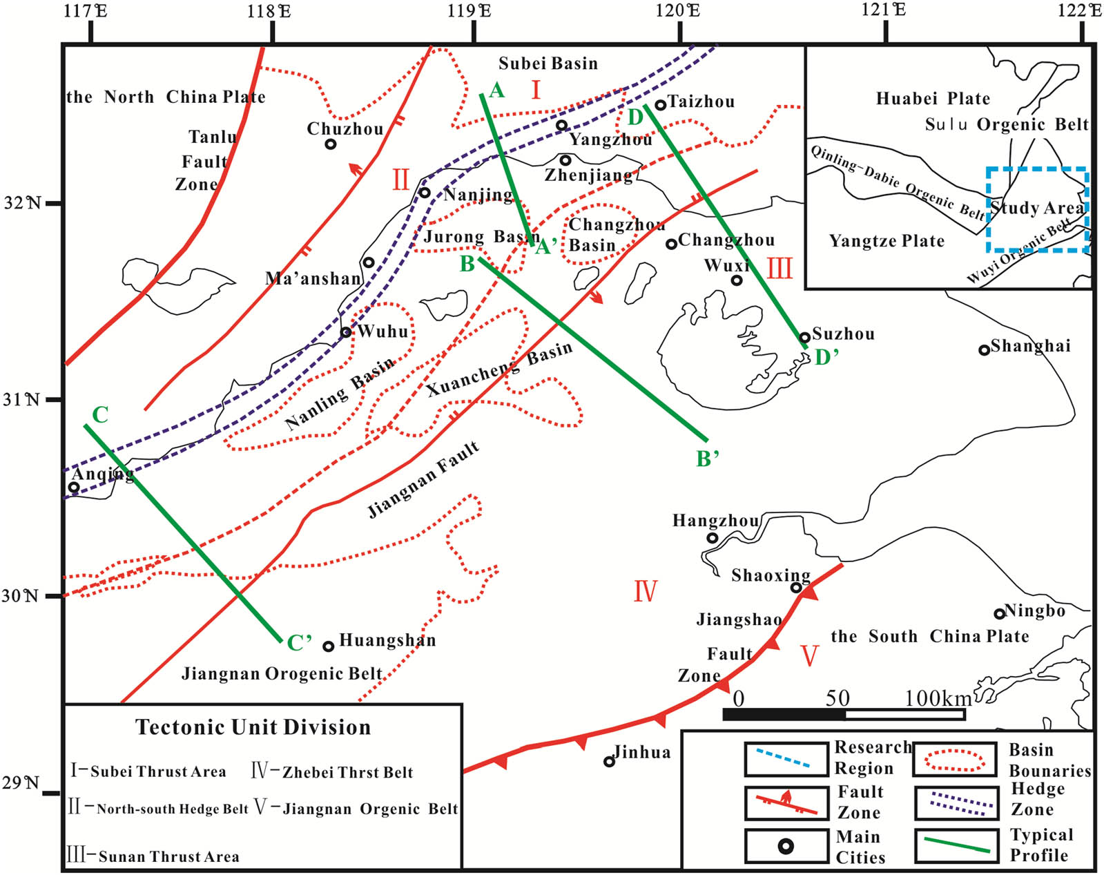
Regional tectonic background of the Lower Yangtze area.
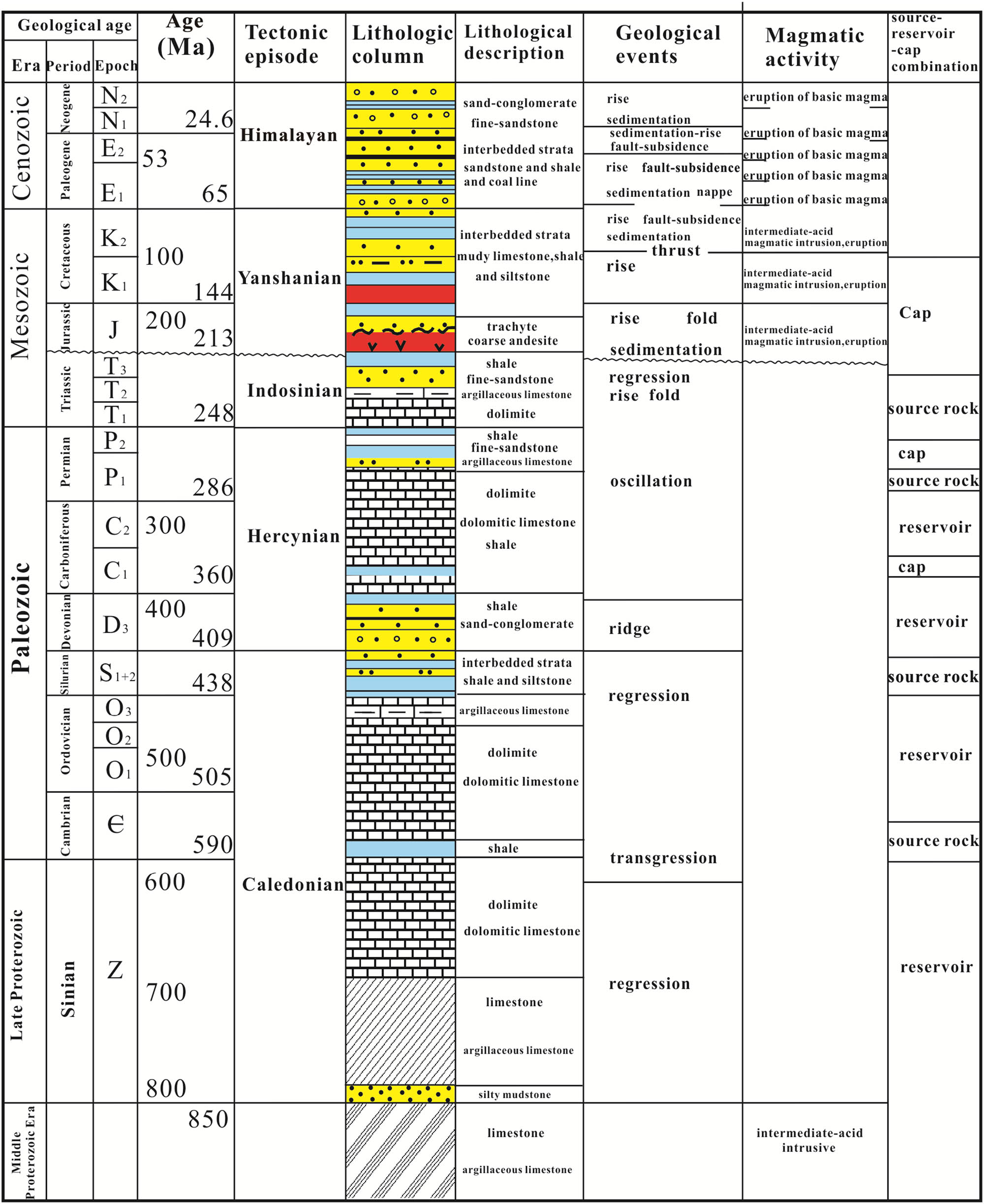
Synthetic stratigraphy of the Lower Yangtze area.
3 Structural deformation characteristics of the Lower Yangtze area
The main regional structural trend of the Lower Yangtze area is along the NE direction and gradually turns northward to a near-NEE direction. Based on a field geological survey and geophysical exploration, four typical geological sections, being perpendicular to the regional structural trend, are established from north to south: the A-A’ (NNW direction), the B-B’ (NW direction), the C-C’ (NW direction), and the D-D’ (NW direction). They are used to understand the regional structural deformation characteristics of the study area (see Figure 1).
3.1 The Jinniu Mountain–Mufu Mountain–Lishui geological section (AA’)
The Jinniu Mountain–Mufu Mountain–Lishui geological section (AA’) is a NNW section perpendicular to the northern structural trend of the study area, passing through structural units of the Subei Basin and Jurong Basin from north to south and passing through Jinniu Mountain, Mufu Mountain, and Qixia Mountain, while extending south to Lishui (see Figure 3). This section exhibits an overall hedging structure centered on the Baohua Mountain anticline. While it shows a SE trending compressional thrust in the north side and shows a NW trending thrust nappe deformation in the south side. Subei Basin, located in the northernmost part of this section, is a typical semi-graben basin in deep layers. The boundary fault of the basin started to form in the Late Triassic Period and experienced a strong reversal in the Late Cretaceous-Eocene Period, finally forming a semi-graben basin with the boundary fault on the north side. In the south part of the Subei Basin, there are three arc-shaped EW trending fold-thrust belts, including the Mufu Mountain, the Qixia Mountain, and the Baohua Mountain. The two wings of these threefold thrust belts are steep, and the thrust faults are extremely developed. The fault surfaces are NW dipping, indicating thrust from the SE direction. The wings of synclines held by the three anticlines are gentle (see Figure 3). Field surveys show that the Lower Cambrian source rocks in this area are well developed. Lower Cambrian (Є1) black carbonaceous shales interbedded with siliceous shales are observed near the Nanjing Mufu Mountain (32.13°N, 118.79°E). The outcrop is weathered, and the rocks are extremely brittle (see Figure 3a). The section (AA’) extends south to the Jurong Basin, which is a semi-graben basin formed in the Late Cretaceous Period. Regional seismic data showed that the Silurian-Jurassic strata in the basin formed a NW trending thrust imbricate structure, and the lower part converged to the detachment layer at the bottom of the Silurian strata [3].
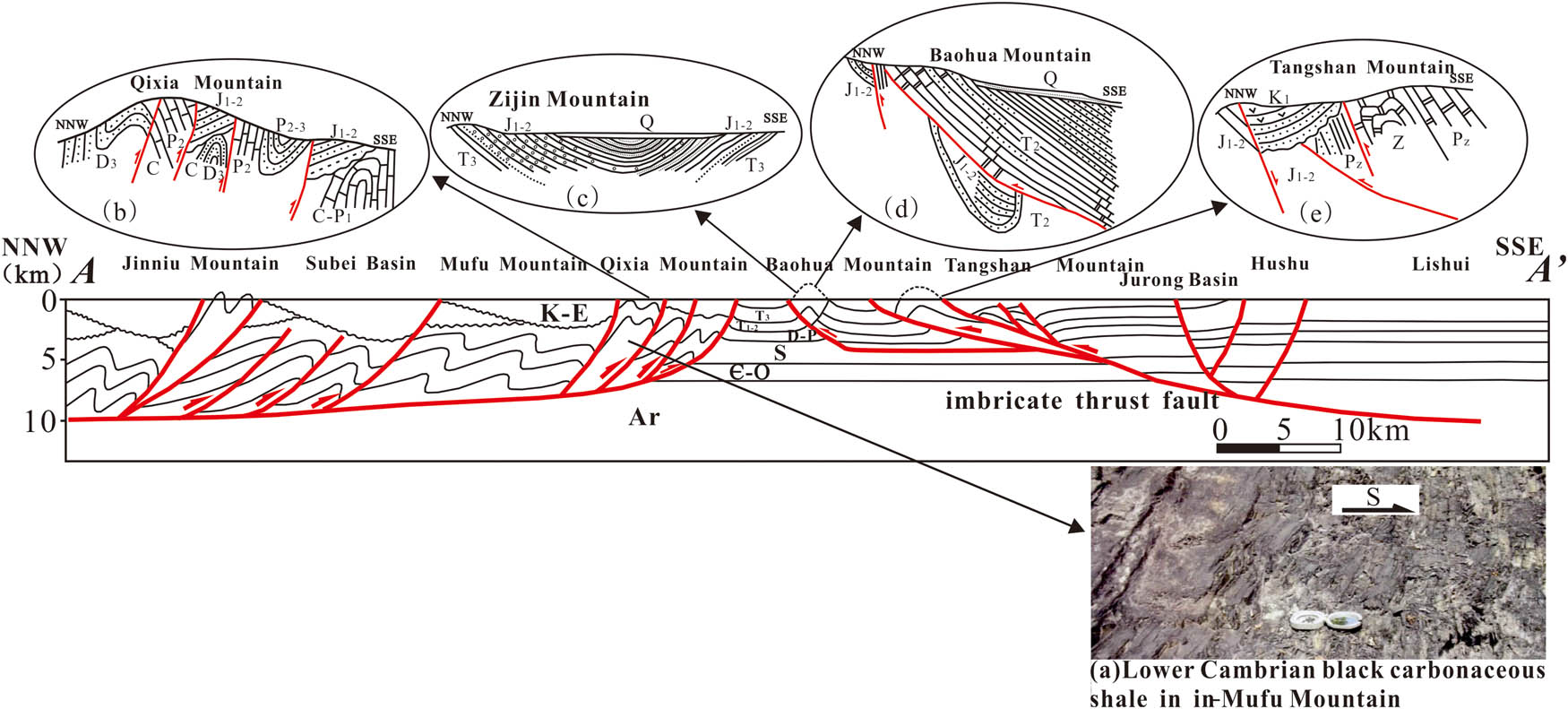
The Jinniu Mountain–Mufu Mountain–Liushui geological section (AA’). (a) Lower Cambrian black carbonaceous shale in Mufu Mountain. (b) Tectonic characteristics of Qixia Mountain. (c) Tectonic characteristics of Zijin Mountain. (d) Tectonic characteristics of Baohua Mountain. (e) Tectonic characteristics of Tangshan Mountain. Ar = Archean formation; Pt = Proterozoic formation; Pz = Paleozoic formation; Mz = Mesozoic formation; Cz = Cenozoic formation; ∈ = Cambrian formation; D-P = Devonian-Permian formation; S = Silurian formation; ∈-O = Cambrian-Ordovician formation; K-E = Cretaceous-Paleogene formation; J1–2 = lower-middle Jurassic formation; P2–3 = middle-upper Permian formation; K1 = upper Cretaceous formation; Q = Quaternary formation; T2 = middle Triassic formation; T3 = upper Triassic formation; C-P1 = Carboniferous-lower Permian formation; D3 = upper Devonian formation.
The Jinniu Mountain–Mufu Mountain–Lishui geological section (AA’) reveals that the northern part of the Lower Yangtze area is centered on the Baohua Mountain anticline, the north and south wings are opposed to the NNW–SSE direction, and experience differing degrees of extensional rifting in the later stages.
3.2 The Maoshan Mountain–Zhangzhu–Changxing geological section (BB’)
The Maoshan Mountain–Zhangzhu–Changxing geological section (BB’) starts in the west of the Maoshan Mountain in the north, passing through the Changzhou–Xuancheng Basin, the Zhangzhu syncline, and the Meishan syncline to the SE, and extends to the Changxing, the Huzhou, in the south, with a total length of 100 km (see Figure 4). The Maoshan Mountain is elongated and NNE trending. Lower Silurian black shales are observed near the Maoshan Mountain Palace (31.79°N, 119.31°E), which is a set of good source rocks that have developed in this area (see Figure 4a). The Maoxi fault, developed on the west side of the Maoshan Mountain, is a low-angle thrust nappe fault with Silurian-Triassic outcropping on the hanging wall. Strong deformation is observed inside the thrust nappe, and a large number of inverted fold structures are develop. The Dinggong anticline, the Qingshan syncline, and the Quanshuidong-Banshan anticline are developed from NW to SE. The cores of the anticlines are mainly Lower Silurian (S1), with steep wings on both sides. The cores of the synclines are the Middle-Lower Triassic (T1–2), of which the axial surface is dipping toward the SE, and the top of the folds are all strongly denuded. The Maodong Fault is a SE-dipping steep normal fault developed on the east side of the Maoshan Mountain (see Figure 4), demonstrating a structural reversal on the basis of earlier thrusts. The Zhangzhu syncline in the middle of the section is a typical monocline dipping toward the center of the basin with a gentle dip angle of about 25°. The structures in this area are relatively simple, dominated by small gentle folds, without the development of typical faults (see Figure 4). There are many basement-involved syncline folds that have developed in Changxing County to the southeast of the section (BB’). The core of the syncline is the Middle-Lower Triassic (T1–2), and the orientation of the fold axis changes from SE to NW. Based on the field survey, Lower Cambrian (Є1) black carbonaceous mud shales, well-developed source rocks in this area, are observed near the Anjiluo Village in Huzhou (30.63°N, 119.67°E; see Figure 4b). On the whole, in the Maoshan Mountain–Zhangzhu–Changxing geological section, except for the Lower Silurian detachment layer existing on the bottom of the Zhangzhu syncline, the other basement-involved deformed strata are generally deeper, reaching to the Cambrian or even older strata.
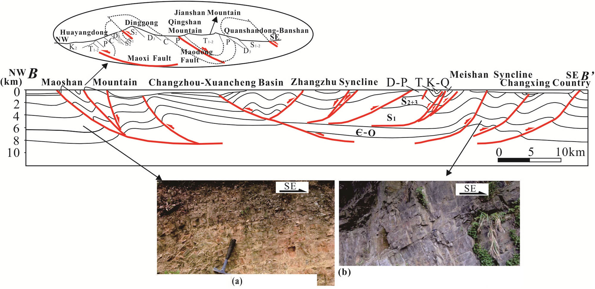
The Maoshan Mountain–Zhangzhu–Changxing geological section (BB’). (a) Lower Silurian black shale in Nanjing. (b) Lower Cambrian black carbonaceous shale in Anjiluo village, Huzhou. ∈-O = Cambrian-Ordovician formation; S1 = upper Silurian formation; S2–3 = middle-upper Silurian formation; D-P = Devonian-Permian formation; T1–2 = upper-middle Triassic formation; K-Q = Cretaceous-Quaternary formation; C = Carboniferous formation; P = Permian formation; D3 = upper Devonian formation; K2 = middle Cretaceous formation.
The Maoshan Mountain–Zhangzhu–Changxing geological section (BB’) demonstrates that the central part of the Lower Yangtze area has experienced a change in the thrust direction from NW to SE, the dynamics of which are mainly derived from the merger of the Yangtze Plate and North China Plate from north to south in the late Indo–Chinese epoch in the Mesozoic era.
3.3 The Qianshan area–Huaining–Dongzhi geological section (CC’)
The Qianshan area–Huaining–Dongzhi geological section starts from the Yuexi County and the Anqing City in Anhui Province in the northwest and extends SE through the Qianshan area, Huaining, and the Wangjiang Basins to theDongzhi County and the Chizhou City in Anhui Province, with a total distance of 120 km (see Figure 5). This section is a NW–SE trending hedging structure on the whole, with the Qianshan Basin on the north side and the Wangjiang Basin on the south side. Both of them are NE trending basins developed from the Late Crataceous-Paleogene period [14].Overall, it is a thrust nappe structure system with SE trending foreland thrust deformation on the west of Changjiang Fault and NW trending thrust on the east side. It can be inferred that the deformation dynamics of the NW part of the section is mainly derived from the thrust of the collision between the North China plate and Yangtze plate in the late period of the Indo-Chinese movement, while the dynamics of the SE part are mainly from intraplate thrust in the early period of the Yanshanian Movement.
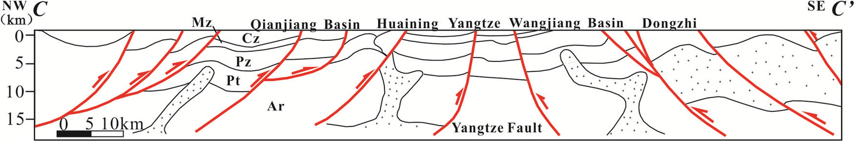
The Qianshan–Huaining–Dongzhi geological section (CC’). Ar = Archean formation; Pt = Proterozoic formation; Pz = Paleozoic formation; Mz = Mesozoic formation; Cz = Cenozoic formation.
3.4 The Taizhou–Wuxi–Jiaxing geological section (DD’)
The Taizhou–Wuxi–Jiaxing geological section starts from Taizhou, Jiangsu Province in the NW. It passes through Jiangyin, Huashan area, Shashan area, Wuxi, Suzhou, and Jiaxing, terminating in Zhejiang Province to the SE, with a total length of about 180 km. Fold structures are widely distributed from the Upper Paleozoic Period to the Triassic Period in this section, presenting a closed anticline and open syncline alternately arranged as a combination of compartments. The true thickness of the same rock layer remains almost constant throughout the folds, showing the typical characteristics of parallel folds (see Figure 6). The NW wing of the anticline is steeper, with a dip angle of more than 60°, while the SE wing is gentler with dip angle of about 45°. Thrust faults are widely distributed along the steeper wing of the folds, with the fault surface dipping to SE. The structure deformation system has changed significantly to the south of Suzhou, with a large number of fault-extended folds developing. In addition, inverted folds are developed in many places in this section, such as the inverted anticline with a SE axial plane in the Shashan area, and the inverted steering inclined syncline with a SE axial plane in Jiaxing area, which further reflects the SE–NW compression in the study area.
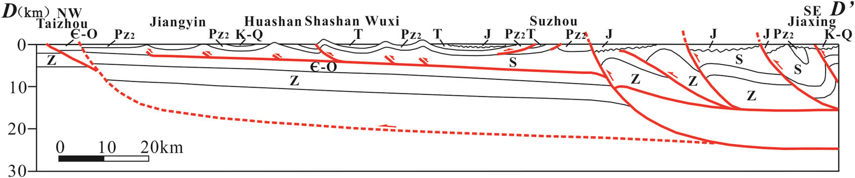
The Taizhou–Wuxi–Jiaxing geological section (DD’). ∈-O = Cambrian-Ordovician formation; S = Silurian formation; J = Jurassic formation; T = Triassic formation; K-Q = Cretaceous-Quaternary formation; Pz2 = middle Paleozoic formation; Z = Sinian formation.
As a whole, the Lower Yangtze area has developed a typical hedging structural system, and the overall structural deformation is not completely symmetrical. Taking the Jinniu Mountain–Mufu Mountain–Lishui geological section and the Qianshan area–Huining–Dongzhi geological section as examples to illustrate the details. Jinniu Mountain–Mufu Mountain–Lishui geological section is characterized by the thrusting deformation centered on the Baohua Mountain anticline, while the north side shows the SE trending compressional thrust and the south side shows the NW trending thrust nappe deformation. Similarly, Qianshan area–Huining–Dongzhi geological section shows the hedging structure deformation centered on the Yangtze River fault, while the western trending thrust toward the SE and the eastern trending thrust toward the NW, showing the evident opposing structure.
4 Structural physical simulation experiment
As mentioned earlier, the hedging system in the typical profile of the study area is distinct: the structure background is relatively stable before the Late Triassic, the boundary fault developed from the Late Triassic and reversed in the Late Cretaceous-Eocene. In terms of the formation mechanism, the hedging system began to develop in the late Indosinian movement and was strongly affected by the Indosinian plate collision and the Yanshan intraplate thrust. A typical hedging structure system is proposed in the Lower Yangtze area, starting from the late Indo-Chinese movement. The structure system is strongly affect by the Indo-China plate collision and the Yanshanianian intraplate thrust. The evolution process of typical profiles in the study area is reconstructed by structural physical simulation experiments, and the dynamic evolution mechanism of the study area is further probed. To study the structural deformation characteristics and evolution mechanism of the Lower Yangtze area further, structural physical simulation experiments are used. The NNW–SSE trending Jinniu Mountain–Mufu Mountain–Lishui geological section (AA’) is selected as the experiment object to illustrate the process of structural evolution within the study area since the Middle Triassic (T2) Period. The experiment details are discussed in the following sections.
4.1 Principles of experimental design
The basic principle of the experiments under laboratory conditions is the principle of similarity, which means the experimental model and the geological prototype should conform to the principle. The indicators of similarity include similar model sizes, similar experimental materials, similar experimental time, and similar boundary conditions [15–17].
4.2 Experimental model and experimental materials
The length and depth of the NNW–SSE trending Jinniu Mountain–Mufu Mountain–Lishui geological section is about 120 km/15 km, respectively, and the experimental model is set to be 100 cm and 12.5 cm, with a similarity coefficient of 1.20 × 10⁻⁵. To facilitating the observation of the experimental deformation results, 80–100 mesh fine-grained loose colored quartz sand was selected as the experimental material, and the friction coefficient of the substrate was less than 3. A 6 cm thick polystyrene foam substrate (pave a certain angle on both sides to achieve thrust napping in deep layers) and 6.5 cm thick quartz sand on the upper part were preinstalled (see Figure 7), with a similarity coefficient of formation thickness of 1.31 × 10⁻⁵ (see Table 1). To avoid the influence of personnel operating proficiency and instrument system error on the experimental accuracy during the experiment, the physical simulation experiment was divided into multiple groups, and cyclic rolling was conducted. The sand-to-mud ratio, stress duration, and rate were all processed differently. The average results of multiple experiments were evaluated [18,19].
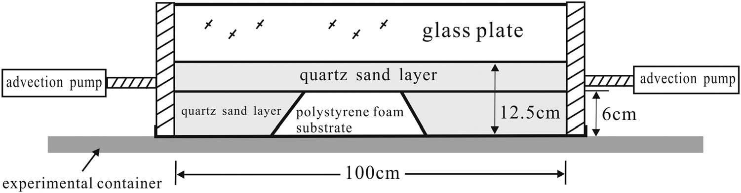
Map showing physical modeling simulation experiment for structural evolution.
Stratum thickness parameters in the structural physical simulation experiment
| Ordinal number of stratum | Geolocial age | Stratum thickness (cm) | Special processes |
|---|---|---|---|
| 1 | Pt | 7.2 | |
| 2 | Pz | 4.5 | |
| 3 | Mz | 4 | Adding 2% vaseline |
| 4 | Cz | 4.3 | Adding 2% vaseline |
Pt = Proterozoic; Pz = Paleozoic; Mz = Mesozoic; Cz = Cenozoic.
4.3 Boundary conditions and loading methods
This structural physical simulation experiment used double-sided extrusion to simulate the compression stress generated by plate activities, orogenic activities, and boundary fault activities. The compression stresses were provided by advection pumps on both sides. The extrusion stress was applied in the SSE direction to simulate the geological period from the Middle Triassic to early Jurassic (T2–J1), and the extrusion stress was applied in the NNW direction to simulate the stress since the Middle Jurassic (J2) period. The magnitude of extrusion stress was controlled by the flowrate of the advection pump. The experiment lasted for 74.2 min, and the time similarity coefficient was 1.86 Ma/min. The advancing speeds of the advection pumps on both sides were 0.25 cm/min (0–4.3 min), 0.27 cm/min (4.3–17.7 min), 0.28 cm/min (17.7–31.1 min), 0.30 cm/min (31.1–39.2 min), and 0.50 cm/min (39.2–74.2 min).
4.4 Experimental process and result analysis
The experiment lasted for 74.2 min and was carried out in two stages.
Stage 1: The polystyrene foam substrate in the experimental container was preinstalled, the quartz sand layer was evenly lay, the right side of the container with a baffle was fixed, and the advancing speed of the left drive unit to 0.25 cm/min was set. When the experiment has run for 4.3 min, the advancing speed was adjusted to 0.27 cm/min. During operation, the SSE-direction extrusion force was generated, and the experimental model began to deform under the stress of the SSE-direction extrusion.
Figure 8a shows the initial state of the experiment. In the unstressed state, the sand body maintained its original state. Under the continuous compression stress from the left side, the left side of the sand body presented a large uplift when the experiment ran for 4.3 min, forming a wide and gentle anticline. Also, the bottom of the right side of the sand body was slightly bent and deformed (see Figure 8b). At 17.7 min, a fault dipping to the NW appeared, named Fault 1, which was a reverse fault, corresponding to the thrust fault at Qixia Mountain in the Jinniu Mountain–Mufu Mountain–Lishui geological section.
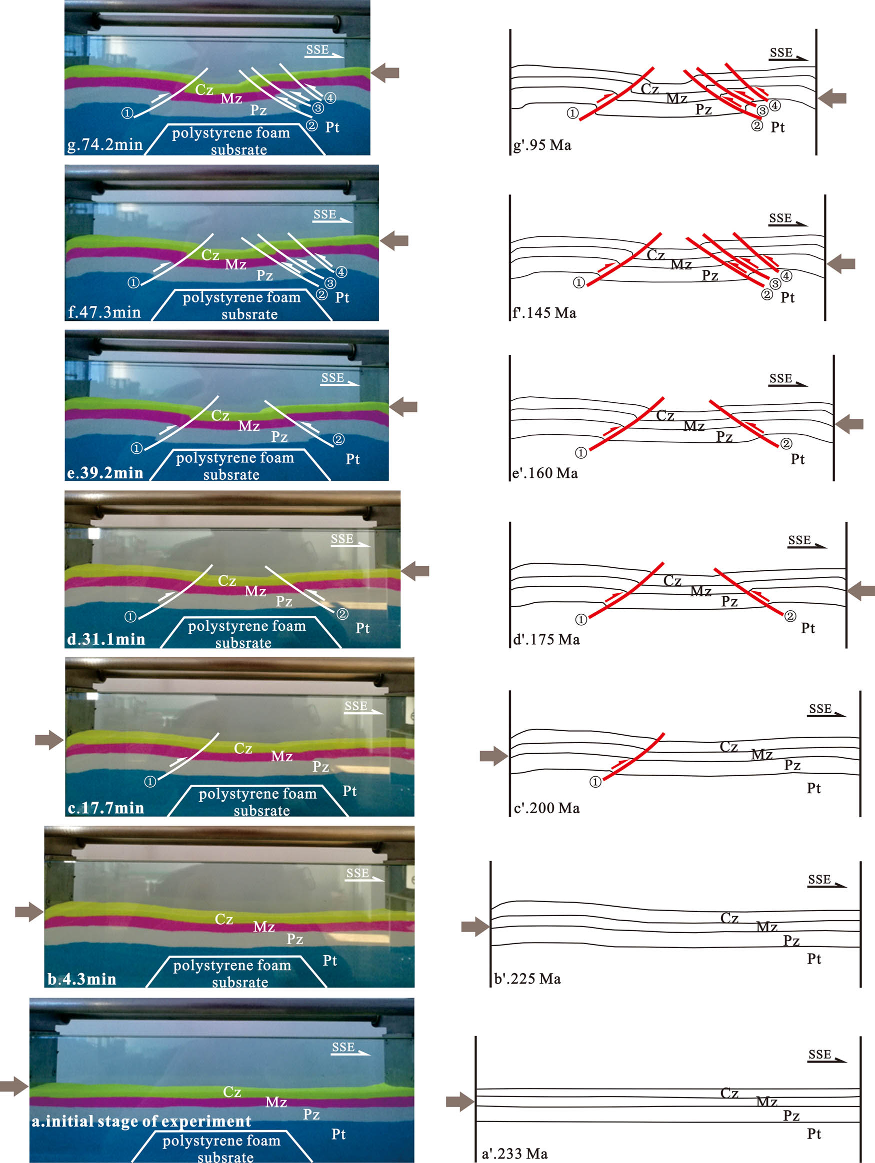
Physical simulation experiment processes and interpretations of the hedging structure in the Lower Yangtze area. (a) Initial stage of the experiment. (b–f) Experiments at 4.3 min, 17.7 min, 31.1 min, 39.2 min, 47.3 min, respectively. (g) The final stage of the experiment at 74.2 min. Pt = Proterozoic formation; Pz = Paleozoic formation; Mz = Mesozoic formation; Cz = Cenozoic formation.
Stage 2: The left side of the container with a baffle was fixed, and the advancing speed of the right drive unit to 0.28 cm/min was set. The advancing speed of the driving was accelerated unit at 31.1 and 39.2 min. NNW compression stress was generated during the process, and the experimental model continued to deform under the NNW extrusion.
When the experiment had run for 31.1 min, the sand body on the right side uplifted rapidly, and Fault 2 began to develop, which was a SE dipping reverse fault. Meanwhile, Fault 1 continued to thrust, and the central sand body subsided relatively. The hedge structure has miniature (see Figure 8d). At 39.2 min, as the compression stress was increased, the deformation of the sand body increased, forming an apparent hedging structure (see Figure 8e). When the experiment had run for 47.3 min, Faults 3 and 4 occurred successively on the hanging wall of Fault 2 on the right side of the sand body. Faults 3 and 4 were also reverse faults dipping to SE, forming an imbricate structure (see Figure 8f). When the experiment had run for 74.2 min, the hedging structure was stable (see Figure 8g). The result of the physical simulation experiment has good correspondence with the structural system of the Jurong Basin in the Jinniu Mountain–Mufu Mountain–Lishui geological section.
5 Analysis of formation mechanism
Based on the analysis of the formation and evolution of the hedging tectonic system in the Lower Yangtze area, the study area undergone two periods of tectonic movement: the Middle-Late Triassic (T2–3) and the Middle-Late Jurassic (J2–3) [20–22]. However, there is rarely systemic and detailed research about the development sequence of the thrust deformation of the hedging structure on both sides in the study area. Based on the geological survey, geophysical exploration, and structural physical simulation experiments, this article study the development and evolution mechanism of the hedge structure since Middle Triassic in the study area. Since the Jin-Ning movement, the Lower Yangtze area has experienced multiple tectonic movements and shaped a typical hedging system. The Indosinian movement, the key tectonic event, changes the tectonic framework of the study area. During the end of the Middle Triassic (T2), the Yangtze plate collided and spliced with the North China plate. With the formation of the Sulu orogenic belt, the Yangtze platform moved northward and presented an “A” type subduction toward the Dabie-Sulu orogenic belt [23]. As a result, the Lower Yangtze area had a strongly SE compression, which was the dynamic source for the formation of the hedging system in the study area. The Lower Yangtze area has experienced multiple periods of the tectonic movement since the Jinning Movement, forming a typical hedging structure. Of all those movements, the Indo-Chinese Movement was a key tectonic movement that has changed the tectonic system in the study area [23]. At the end of the Middle Triassic (T2) era, the Yangtze plate converged and collided with the North China plate. With the formation of the Sulu orogenic belt, the Lower Yangtze area was strongly compressed from the SE direction [24], providing dynamic drives for the formation of the hedging tectonic system. The field data provide strong evidence for the importance of the Indo-Chinese Movement on the deformation of the study area. The anticline at the Qixia Mountain (32.15°N, 118.95°E) in Nanjing is well developed, with a strongly deformed Silurian-Triassic core and steep wings. In contrast, the overlying rock (J) is gentle and without strong deformation. Typical unconformity can be observed between these two layers (see Figure 6). There is a parallel unconformity between the overlying J1–2 and the underlying T3 from Qixia Mountain to Zijin Mountain (32.07°N, 118.83°E), with uniform deformation characteristics (see Figure 3b). In Huaining, which is the west of the study area, the overlying J1 and the underlying T2–3 also have a significant shift from angle unconformity to parallel unconformity [25]. All of these indicate that the Indo-Chinese Movement has an evident controlling on the NW side of the hedging structure, while the controlling on the SE side is relatively weak. Meanwhile, structural physical simulation experiments indicate that the Lower Yangtze area has been continuously compressed in the SSE direction since the Middle Triassic era [26].Until 200 Ma, corresponding to the end of the Late Triassic, anticline and thrust faults developed on the NW side, while the SE side was relatively stable without significant deformation (see Figure 8a–c). This is verified by the field data, which further confirm that the structural deformation in the Indo-Chinese period in the study area mainly occurs on the NW side of the hedging structure system.
Since the Middle Jurassic (J2) era, the Yanshanian Movement has become another important tectonic event that has changed the structural framework of the study area. During this period, the Pacific plate subducted in the NW direction under the Eurasian continent. The subduction was quite active in the Late Jurassic Period, which induced large-scale magma activities. At the same time, restricted by the mid-Pacific ridge, the Pacific subduction in eastern part of China transformed into a left-lateral transpression [26]. In this dynamic environment, the Lower Yangtze area was strongly compressed in the NW direction, and the hedging system continued to develop. The field data provide strong evidence for the development of the hedging structure of the study area. Middle Triassic (T2) breccia limestone was widely exposed on the NW wing of the anticline on Baohua Mountain (32.14°N, 119.09°E) in Jurong City. The high angle breccia limestone thrusted above the Lower-Middle Jurassic (J1–2) sandstone at a high angle in the NW direction (see Figure 3i). Southeastward to the Tangshan area (32.06°N, 119.05°E), the Upper Sinian and Paleozoic (Pz) thrusted onto the Lower-Middle Jurassic (J1–2) and the Middle-Upper Triassic (T2–3), while thrust faults on the NNW side developed to Lower-Middle Jurassic and was underlid by Lower Cretaceous (K1) angle unconformity (see Figure 3d). Therefore, the southern thrust structure of the hedging system mainly developed in the Middle-Late Jurassic period. In addition, the results of the structural physical simulation experiments showed that since 175 Ma (the beginning of the Middle Jurassic era), the SE side of the section was influenced by the continuously influence of the NNW compression and that it deformed significantly. In the Middle-Late Jurassic era, three steep thrust faults developed successively, showing a typical “up-stack” development sequence. However, the NW side of the study area was relatively stable and the deformation was not evident. The hedging structure of the study area was formed (see Figure 8d–j). This was verified by the field data, which further confirm that the structural deformation in the SE of the hedging system mainly occurred in the Mid-Late Jurassic era.
6 The implications for petroleum exploration
In the Cretaceous era, with the terminal of the large-scale magmatic activity, the compressive structural deformation of the Lower Yangtze area was replaced by regional extension. Influenced by the Cenozoic tectonic activities, the north and south sides of the Mesozoic hedging system show significant differences. On the NW side of the hedging system, the basins are semi-graben controlled by the north fault (the Qianshan Basin and the Subei Basin), whereas on the SE side of the hedging system, the basins are semi-graben controlled by the south fault (the Wangjiang Basin and the Jurong Basin) [27–29].
The Lower Yangtze area is a favorable place for hydrocarbon production and has great exploration potential in the Paleozoic-Mesozoic stratum. However, the Lower Yangtze area has been affected by multiple stages of reconstruction and destruction, and the preservation conditions are poor. Hydrocarbon reservoirs in good conditions have not been discovered yet. According to our detailed analysis of the deformation characteristics in this article, with many parts of the Upper Paleozoic being exposed to the surface through structural deformation, there are poor petroleum preservation conditions in the study area. Therefore, the key for a breakthrough in petroleum exploration of this area is to find weak structural deformation and transformation play. Taking the Taizhou–Wuxi–Jiaxing geological survey as an example to illustrate the detail. The Lower Paleozoic stratum in the Wuxi area is weakly affected by structural deformation and is well preserved. The deformation characteristics of the Upper Paleozoic stratum are consistent with the Lower Paleozoic, showing a stable distribution of parallel folds, which might therefore be a favorable exploration area. In addition, the source rocks are well developed in the Wuxi area. The Lower Cambrian (Є1) stratum, the Upper Ordovician Wufeng Formation (O3w), the Lower Silurian stratum (S1), and Lower Permian stratum (P1) are the main source rocks in the region. These source rocks, characterized by mature to over-mature, have abundant total organic carbon and good organic types and have great potential for oil generation. Meanwhile, the source rocks are thick and widely distributed, which could also act as good reservoirs [30,31]. The results of this study suggest that the source-reservoir-seal conditions are superior, and structural conditions are relatively stable in the Wuxi area of the Lower Yangtze area, which might be a potential exploration zone in the study area.
7 Conclusion
Based on the geological survey, geophysical exploration, and structural physical simulations experiments, there is a typical hedging system in the Lower Yangtze area, which is characterized by “asymmetric hedging in the South and North.” The overall structure is a two-sided opposing structure, with the southern thrust belt thrusting toward the NW and the northern thrust belt thrusting towards the SE.
The hedging structural framework in the Lower Yangtze area was formed from two tectonic movements: the Middle-Late Triassic (T2–3) movement and the Middle-Late Jurassic (J2–3) movement. The structural deformation in the NW part of the hedging system, controlled by SE compression in the Indo-Chinese period, mainly occurred in the Middle-Late Triassic. While the deformation of SE side of the hedging system, controlled by NW strong compression in the early period of the Yanshanian Movement, mainly happened in the Middle-Late Jurassic.
The deformation is weak in the Wuxi area, and the petroleum preservation condition is preferable because this area has not been intensively modified in later periods. Besides, other factors of petroleum accumulation, including the source rocks, reservoirs, and sealing conditions, are superior, making this area potential for petroleum exploration.
Acknowledgments
We greatly appreciate anonymous reviewers for their constructive and detailed reviews and suggestions on the manuscript. The project was supported by the National Nature Science Foundation of China (42072162).
-
Author contributions: Xiao Li and Qiuyuan Hu: designed the experiments; Dawei Dong: carried them out; Shaobin Guo: valuable suggestions; Xiao Li: prepared the manuscript with contributions from all co-authors.
-
Conflict of interest: Authors state no conflict of interest.
References
[1] Mei LF, Guo TL, Shen CB. Tectonic-hydrocarbon accumulation cycles of marine strata in polycyclic superimposed and reconstructed basins in Southern China. J China Univ Geosci. 2007;18(special issue):538–9.Search in Google Scholar
[2] Yin L, Qinghua C, Kai H. Comparison of the Bohai Bay Basin and Subei-South Yellow Sea Basin in the structural characteristics and forming mechanism. Geotecton Metallog. 2014;38:38–51.Search in Google Scholar
[3] Haibin L, Dong J, Long W. The Mesozoic-Cenozoic compressional deformation, extensional modification and their significance for hydrocarbon exploration in lower Yangtze region. Acta Petrol Sin. 2011;27:770–8.Search in Google Scholar
[4] Shuxin S, Yiquan L, Jian C. The structural characteristics in Huangqiao area in the lower Yangtze region and its relationship to oil and gas accumulation. Geol J Chin Univ. 2015;2:538–52.Search in Google Scholar
[5] Dongyan W, Jinning P, Qi Q. Hydrocarbon accumulation model and controlling factors in the Upper Paleozoic in Jurong area, Lower Yangtze region. Pet Geol Exp. 2017;39:640–6.Search in Google Scholar
[6] Shi G, Xu ZY, Zheng HJ. “Three-gas-one-oildrilling” findings and reservoir formation geological conditions in the Lower Yangtze area: exemplified by Gang Di 1 well in South Anhui. Geol Bull China. 2019;38:1564–70.Search in Google Scholar
[7] Jianbo D, Mingxi H, Yanxia Z. Tectonic evolution and sedimentary characteristics of the foreland basin in the northern part of Lower Yangtze area. Pet Geol Exp. 2007;29:133–7.Search in Google Scholar
[8] Yahui L, Hongliang D, Ying T. Structural division of marine mesozoic-paleozoic in lower Yangtze region and its significance for petroleum exploration targets. J Geomech. 2010;16:271–80.Search in Google Scholar
[9] Zhengqing H. Tectonic evolutionary characteristics and the main enriched layers of shale gases in the lower Yangtze basins. Shanghai Land Resour. 2017;38:87–92.Search in Google Scholar
[10] Yonghong Z. Huangqiao transform event in tectonic evolution of lower Yangtze region and the Meso-Paleozoic hydrocarbon exploration target. Oil Gas Geol. 1991;12:439–48.Search in Google Scholar
[11] Nianfa G, Xiaozhong Y, Defa L. Petroleum geological conditions and exploration areas of Paleozoic in Lower Yangtze area. Pet Explor Dev. 1998;25:20–3.Search in Google Scholar
[12] Nianfa G, Hongge Z, Hong C. Oil-gas occurrence conditions and evaluation of chosen belts of the marine strata in Yangtze area. J Northwest Univ (Nat Sci Ed). 2002;32:526–30.Search in Google Scholar
[13] Lin W, Qinghua C, Fei P. Mesozoic-Cenozoic tectonic deformation units and styles in lower Yangtze region. J Jilin Univ Earth Sci Ed. 2015;45:1722–34.Search in Google Scholar
[14] Yikai Z. Study on formation evolution and hydrocarbon bearing system of Wangjiang-Qianshan Basin. Northwest Univ. 2003;1:25–7.Search in Google Scholar
[15] Jiazeng S, Zhanwen Z, Qianhua X. Modeling experiments of two-phase structural evolution in the Liaohe Depression, Paleogene. Pet Explor Dev. 2004;31:14–7.Search in Google Scholar
[16] Shijun Z, Xiaodong L. Study on the experiment ways of geological structure physical modeling. Pet Instrum. 2010;24:40–2.Search in Google Scholar
[17] Fei N, Liangjie T. Advances of research on physical modeling in compressional area. Glob Geol. 2009;28:345–50.Search in Google Scholar
[18] Ying W, Yingmin W, Xikui Z. Application of simulation experiment to the study of structural evolution—an example of the Zhuangxi Buried Hill. Pet Geol Exp. 2004;26:308–12.Search in Google Scholar
[19] Menglin Z, Zhijun J. NE-trending structures and their significance on petroleum geology in Junggar Basin. Earth Sci – J China Univ Geosci. 2004;29:467–72.Search in Google Scholar
[20] Jianjian Z, Fengli Y, Wenfang Z. Tectonic characteristics and numerical stress field simulation in Indosinian-early Yanshannian stage, lower Yangtze region. Geol J Chin Univ. 2010;16:475–82.Search in Google Scholar
[21] Weixing D, Ting Z, Sheng Z. Characteristics of structural deformation in the northern part of lower Yangtze foreland basin. Comp Hydroc Reserv. 2013;6:1–6.Search in Google Scholar
[22] Sanzhong L, Guowei Z, Shuwen D. Relation between exhumation of HP-UHP metamorphic rocks and deformation in the northern margin of the Yangtze block. Acta Petrol Sin. 2010;26:3549–62.Search in Google Scholar
[23] Daogui D, Fengli L. Mesozoic and Cenozoic diktyogenese in the lower Yangtze region. Pet Geol Exp. 2020;42:687–97+876.Search in Google Scholar
[24] Baohua L, Jianwen C, Jie L. Tectonic deformation and evolution of the South Yellow Sea basin since Indosinian movement. Mar Geol Quat Geol. 2018;38:45–54.Search in Google Scholar
[25] Jingyuan L. Quasi-platform polycyclic fold deformation—Mesozoic structure in Huaining area Anhui province. Geol Rev. 2019;25:58–63.Search in Google Scholar
[26] Xiaohui D. Formation and evolution of ramp structural system of Mesozoic and Paleozoic in the eastern edge of middle Yangtze region. Yangtze Univ. 2011;7:22–6.Search in Google Scholar
[27] Xi X, Xiaoying Z, Xipeng S. Structure and sedimentary characteristics of the Meso-Cenozoic basin group along the Yangtze river in the lower Yangtze region. Pet Geol Exp. 2018;40:303–14.Search in Google Scholar
[28] Lihua Z. The tectonic evolution of basin and its controlling on oil and gas in the Lower Yangtze area, Nanjing. Nanjing Univ. 2001;5:31–5.Search in Google Scholar
[29] Anding C. Tectonic features of the Subei Basin and the forming mechanism of its dustpan-shaped fault depression. Oil Gas Geol. 2010;31:140–50.Search in Google Scholar
[30] Lin G, Yan Z. Evaluation and potential analysis on source rocks in Mesozoic and Paleozoic marine sequence, Middle-Lower Yangtze area. Pet Geol Recov Effic. 2009;16:30–3.Search in Google Scholar
[31] Xi X, Fengli Y, Wenfang Z. Analysis of characteristics of upper hydrocarbon play of Mesozoic-Paleozoic marine group, lower Yangtze region. Offshore Oil. 2011;31:48–53.Search in Google Scholar
© 2021 Xiao Li et al., published by De Gruyter
This work is licensed under the Creative Commons Attribution 4.0 International License.
Articles in the same Issue
- Regular Articles
- Lithopetrographic and geochemical features of the Saalian tills in the Szczerców outcrop (Poland) in various deformation settings
- Spatiotemporal change of land use for deceased in Beijing since the mid-twentieth century
- Geomorphological immaturity as a factor conditioning the dynamics of channel processes in Rządza River
- Modeling of dense well block point bar architecture based on geological vector information: A case study of the third member of Quantou Formation in Songliao Basin
- Predicting the gas resource potential in reservoir C-sand interval of Lower Goru Formation, Middle Indus Basin, Pakistan
- Study on the viscoelastic–viscoplastic model of layered siltstone using creep test and RBF neural network
- Assessment of Chlorophyll-a concentration from Sentinel-3 satellite images at the Mediterranean Sea using CMEMS open source in situ data
- Spatiotemporal evolution of single sandbodies controlled by allocyclicity and autocyclicity in the shallow-water braided river delta front of an open lacustrine basin
- Research and application of seismic porosity inversion method for carbonate reservoir based on Gassmann’s equation
- Impulse noise treatment in magnetotelluric inversion
- Application of multivariate regression on magnetic data to determine further drilling site for iron exploration
- Comparative application of photogrammetry, handmapping and android smartphone for geotechnical mapping and slope stability analysis
- Geochemistry of the black rock series of lower Cambrian Qiongzhusi Formation, SW Yangtze Block, China: Reconstruction of sedimentary and tectonic environments
- The timing of Barleik Formation and its implication for the Devonian tectonic evolution of Western Junggar, NW China
- Risk assessment of geological disasters in Nyingchi, Tibet
- Effect of microbial combination with organic fertilizer on Elymus dahuricus
- An OGC web service geospatial data semantic similarity model for improving geospatial service discovery
- Subsurface structure investigation of the United Arab Emirates using gravity data
- Shallow geophysical and hydrological investigations to identify groundwater contamination in Wadi Bani Malik dam area Jeddah, Saudi Arabia
- Consideration of hyperspectral data in intraspecific variation (spectrotaxonomy) in Prosopis juliflora (Sw.) DC, Saudi Arabia
- Characteristics and evaluation of the Upper Paleozoic source rocks in the Southern North China Basin
- Geospatial assessment of wetland soils for rice production in Ajibode using geospatial techniques
- Input/output inconsistencies of daily evapotranspiration conducted empirically using remote sensing data in arid environments
- Geotechnical profiling of a surface mine waste dump using 2D Wenner–Schlumberger configuration
- Forest cover assessment using remote-sensing techniques in Crete Island, Greece
- Stability of an abandoned siderite mine: A case study in northern Spain
- Assessment of the SWAT model in simulating watersheds in arid regions: Case study of the Yarmouk River Basin (Jordan)
- The spatial distribution characteristics of Nb–Ta of mafic rocks in subduction zones
- Comparison of hydrological model ensemble forecasting based on multiple members and ensemble methods
- Extraction of fractional vegetation cover in arid desert area based on Chinese GF-6 satellite
- Detection and modeling of soil salinity variations in arid lands using remote sensing data
- Monitoring and simulating the distribution of phytoplankton in constructed wetlands based on SPOT 6 images
- Is there an equality in the spatial distribution of urban vitality: A case study of Wuhan in China
- Considering the geological significance in data preprocessing and improving the prediction accuracy of hot springs by deep learning
- Comparing LiDAR and SfM digital surface models for three land cover types
- East Asian monsoon during the past 10,000 years recorded by grain size of Yangtze River delta
- Influence of diagenetic features on petrophysical properties of fine-grained rocks of Oligocene strata in the Lower Indus Basin, Pakistan
- Impact of wall movements on the location of passive Earth thrust
- Ecological risk assessment of toxic metal pollution in the industrial zone on the northern slope of the East Tianshan Mountains in Xinjiang, NW China
- Seasonal color matching method of ornamental plants in urban landscape construction
- Influence of interbedded rock association and fracture characteristics on gas accumulation in the lower Silurian Shiniulan formation, Northern Guizhou Province
- Spatiotemporal variation in groundwater level within the Manas River Basin, Northwest China: Relative impacts of natural and human factors
- GIS and geographical analysis of the main harbors in the world
- Laboratory test and numerical simulation of composite geomembrane leakage in plain reservoir
- Structural deformation characteristics of the Lower Yangtze area in South China and its structural physical simulation experiments
- Analysis on vegetation cover changes and the driving factors in the mid-lower reaches of Hanjiang River Basin between 2001 and 2015
- Extraction of road boundary from MLS data using laser scanner ground trajectory
- Research on the improvement of single tree segmentation algorithm based on airborne LiDAR point cloud
- Research on the conservation and sustainable development strategies of modern historical heritage in the Dabie Mountains based on GIS
- Cenozoic paleostress field of tectonic evolution in Qaidam Basin, northern Tibet
- Sedimentary facies, stratigraphy, and depositional environments of the Ecca Group, Karoo Supergroup in the Eastern Cape Province of South Africa
- Water deep mapping from HJ-1B satellite data by a deep network model in the sea area of Pearl River Estuary, China
- Identifying the density of grassland fire points with kernel density estimation based on spatial distribution characteristics
- A machine learning-driven stochastic simulation of underground sulfide distribution with multiple constraints
- Origin of the low-medium temperature hot springs around Nanjing, China
- LCBRG: A lane-level road cluster mining algorithm with bidirectional region growing
- Constructing 3D geological models based on large-scale geological maps
- Crops planting structure and karst rocky desertification analysis by Sentinel-1 data
- Physical, geochemical, and clay mineralogical properties of unstable soil slopes in the Cameron Highlands
- Estimation of total groundwater reserves and delineation of weathered/fault zones for aquifer potential: A case study from the Federal District of Brazil
- Characteristic and paleoenvironment significance of microbially induced sedimentary structures (MISS) in terrestrial facies across P-T boundary in Western Henan Province, North China
- Experimental study on the behavior of MSE wall having full-height rigid facing and segmental panel-type wall facing
- Prediction of total landslide volume in watershed scale under rainfall events using a probability model
- Toward rainfall prediction by machine learning in Perfume River Basin, Thua Thien Hue Province, Vietnam
- A PLSR model to predict soil salinity using Sentinel-2 MSI data
- Compressive strength and thermal properties of sand–bentonite mixture
- Age of the lower Cambrian Vanadium deposit, East Guizhou, South China: Evidences from age of tuff and carbon isotope analysis along the Bagong section
- Identification and logging evaluation of poor reservoirs in X Oilfield
- Geothermal resource potential assessment of Erdaobaihe, Changbaishan volcanic field: Constraints from geophysics
- Geochemical and petrographic characteristics of sediments along the transboundary (Kenya–Tanzania) Umba River as indicators of provenance and weathering
- Production of a homogeneous seismic catalog based on machine learning for northeast Egypt
- Analysis of transport path and source distribution of winter air pollution in Shenyang
- Triaxial creep tests of glacitectonically disturbed stiff clay – structural, strength, and slope stability aspects
- Effect of groundwater fluctuation, construction, and retaining system on slope stability of Avas Hill in Hungary
- Spatial modeling of ground subsidence susceptibility along Al-Shamal train pathway in Saudi Arabia
- Pore throat characteristics of tight reservoirs by a combined mercury method: A case study of the member 2 of Xujiahe Formation in Yingshan gasfield, North Sichuan Basin
- Geochemistry of the mudrocks and sandstones from the Bredasdorp Basin, offshore South Africa: Implications for tectonic provenance and paleoweathering
- Apriori association rule and K-means clustering algorithms for interpretation of pre-event landslide areas and landslide inventory mapping
- Lithology classification of volcanic rocks based on conventional logging data of machine learning: A case study of the eastern depression of Liaohe oil field
- Sequence stratigraphy and coal accumulation model of the Taiyuan Formation in the Tashan Mine, Datong Basin, China
- Influence of thick soft superficial layers of seabed on ground motion and its treatment suggestions for site response analysis
- Monitoring the spatiotemporal dynamics of surface water body of the Xiaolangdi Reservoir using Landsat-5/7/8 imagery and Google Earth Engine
- Research on the traditional zoning, evolution, and integrated conservation of village cultural landscapes based on “production-living-ecology spaces” – A case study of villages in Meicheng, Guangdong, China
- A prediction method for water enrichment in aquifer based on GIS and coupled AHP–entropy model
- Earthflow reactivation assessment by multichannel analysis of surface waves and electrical resistivity tomography: A case study
- Geologic structures associated with gold mineralization in the Kirk Range area in Southern Malawi
- Research on the impact of expressway on its peripheral land use in Hunan Province, China
- Concentrations of heavy metals in PM2.5 and health risk assessment around Chinese New Year in Dalian, China
- Origin of carbonate cements in deep sandstone reservoirs and its significance for hydrocarbon indication: A case of Shahejie Formation in Dongying Sag
- Coupling the K-nearest neighbors and locally weighted linear regression with ensemble Kalman filter for data-driven data assimilation
- Multihazard susceptibility assessment: A case study – Municipality of Štrpce (Southern Serbia)
- A full-view scenario model for urban waterlogging response in a big data environment
- Elemental geochemistry of the Middle Jurassic shales in the northern Qaidam Basin, northwestern China: Constraints for tectonics and paleoclimate
- Geometric similarity of the twin collapsed glaciers in the west Tibet
- Improved gas sand facies classification and enhanced reservoir description based on calibrated rock physics modelling: A case study
- Utilization of dolerite waste powder for improving geotechnical parameters of compacted clay soil
- Geochemical characterization of the source rock intervals, Beni-Suef Basin, West Nile Valley, Egypt
- Satellite-based evaluation of temporal change in cultivated land in Southern Punjab (Multan region) through dynamics of vegetation and land surface temperature
- Ground motion of the Ms7.0 Jiuzhaigou earthquake
- Shale types and sedimentary environments of the Upper Ordovician Wufeng Formation-Member 1 of the Lower Silurian Longmaxi Formation in western Hubei Province, China
- An era of Sentinels in flood management: Potential of Sentinel-1, -2, and -3 satellites for effective flood management
- Water quality assessment and spatial–temporal variation analysis in Erhai lake, southwest China
- Dynamic analysis of particulate pollution in haze in Harbin city, Northeast China
- Comparison of statistical and analytical hierarchy process methods on flood susceptibility mapping: In a case study of the Lake Tana sub-basin in northwestern Ethiopia
- Performance comparison of the wavenumber and spatial domain techniques for mapping basement reliefs from gravity data
- Spatiotemporal evolution of ecological environment quality in arid areas based on the remote sensing ecological distance index: A case study of Yuyang district in Yulin city, China
- Petrogenesis and tectonic significance of the Mengjiaping beschtauite in the southern Taihang mountains
- Review Articles
- The significance of scanning electron microscopy (SEM) analysis on the microstructure of improved clay: An overview
- A review of some nonexplosive alternative methods to conventional rock blasting
- Retrieval of digital elevation models from Sentinel-1 radar data – open applications, techniques, and limitations
- A review of genetic classification and characteristics of soil cracks
- Potential CO2 forcing and Asian summer monsoon precipitation trends during the last 2,000 years
- Erratum
- Erratum to “Calibration of the depth invariant algorithm to monitor the tidal action of Rabigh City at the Red Sea Coast, Saudi Arabia”
- Rapid Communication
- Individual tree detection using UAV-lidar and UAV-SfM data: A tutorial for beginners
- Technical Note
- Construction and application of the 3D geo-hazard monitoring and early warning platform
- Enhancing the success of new dams implantation under semi-arid climate, based on a multicriteria analysis approach: Case of Marrakech region (Central Morocco)
- TRANSFORMATION OF TRADITIONAL CULTURAL LANDSCAPES - Koper 2019
- The “changing actor” and the transformation of landscapes