Awheel Along Europe’s Rivers: Geoarchaeological Trails for Cycling Geotourists
-
Thomas A. Hose


Abstract
This review study presents an overview of the potential for the development of geoarchaeological trails for leisure cyclists in Europe. It initially defines and discusses the underpinning key concepts and then examines the nature and main needs of leisure cyclists. It considers and recognises appropriate geo-interpretative themes, of geological/geomorphological and archaeological/historical interest, to employ in developing the trails. Noting that river valleys have long been natural route-ways for human expansion into Europe (as exemplified by the ‘Stone Age’ and the Roman Empire), and that many of today’s major cycle trails are beside rivers with loess deposits, a geoarchaeological geotourism strategy is considered in relation to them. Case studies of specific sites, from central southern England, the Middle Danube and Middle Rhine valleys, outline the current provision and the basis of the proposed trails. Finally, a common relatively low-cost, mixed media, geo-interpretative and promotional approach could generate the impetus to further develop the strategy is suggested.
1 Introduction
1.1 Opening Remarks
At the outset it should be noted that Europe’s geoheritage is not accorded the recognition, resources and statutory protection given to the continent’s archaeological and historical sites and their artefacts. Therefore, a geotourism approach that melds geoheritage with archaeological heritage is potentially a fruitful collaboration for geoconservation purposes. The suggestion that for much of Europe’s geoheritage ‘A pan-European integrated geotourism and geoconservation strategy really is necessary to protect the remaining legacy of important and interesting sites from sheer neglect, infilling, development and restorative environmental works.’ [1] still seems to be a truism, part met by the work of the various national and regional ProGEO groups [2]. Such a pan-European approach, as perhaps suggested by the ProGEO Protocol [2], to engage with existing and new stakeholders, requires that for ‘…communicative success and conservation effectiveness, interpretative provision needs to be widespread and appropriate to host site and culture.’ [1]. Therefore, this paper reports a scoping study for a geoarchaeological themed geotourism project, underpinned by a sound theoretical consideration (Figure 1), as a possible means to kick-start such an approach that should encourage engagement with existing and potential new stakeholders to further European geoconservation.
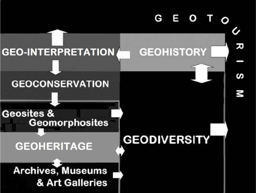
Topological representation of the 4Gs of geotourism – This shows the interrelationships of geoconservation, geohistory, geo-interpretation; and geodiversity
Since most geotourism provision requires visitors to primary geosites (and geomorphosites) mainly to get to them by private car or tourist coach this seems at odds with the tourism sector’s interest in sustainable tourism; hence, a more environmentally-friendly transport mode would seem an innovative approach to adopt for this study. With bicycles widely recognised as the most environmentally-friendly and sustainable form of transport [3], it is opportune to consider the development of geotourism linked to leisure cycling, albeit as a niche (geo)tourism [4, 5] market. Leisure cyclists were selected as the primary audience because they are a growing European leisure market [6]. Leisure cycling is particularly popular with families. It also appeals to, especially touring, sporty individuals aged 40-60 years [7]. The introduction of electric-motor-assisted bicycles (e-bikes) has created a new leisure market of older leisure cyclists [7] now better able to tackle hilly areas; e-bike sales account for 10-15% of European bicycle sales [3]. Many, particularly touring, cyclists are well-educated individuals with moderate to high levels of disposable income [7]. In planning their trips they use a broad spectrum of information media, with an increasing emphasis on mobile-technology based sources [7]; they usually include significant attractions and refreshment facilities in their routes.
1.2 Geotourism and Geotourists
Geotourism is a geologically-based contemporary paradigm [8] for landscape promotion and geoconservation. It is ‘The provision of interpretative and service facilities for geosites and geomorphosites and their encompassing topography, together with their associated in situ and ex situ ‘artefacts’, to constituency-build for their conservation by generating appreciation, learning and research by and for current and future generations’ [9]. It links onsite geoheritage (primary geosites/geomorphosites) generally in rural settings particularly with offsite geoheritage in museums (secondary geosites) mainly in urban settings. A geotourism review [9] drew attention to its ‘3Gs’ of geoconservation, geohistory, and geo-interpretation; later amended [10] to ‘4Gs’ (Figure 1) with the inclusion of geodiversity [11], of which geoheritage is a major cultural element [10]. Geosites and geomorphosites presented and interpreted for geotourism purposes are valued by their host communities and visitors (that is geotourists), thus helping to ensure their long-term preservation and accessibility.
Geotourists can be categorised as either ‘Educational’ and ‘Recreational’ [12] or ‘Dedicated’ and ‘Casual’ [1]. The former of each pair of opposites typically are academic, student and amateur geologists. The latter of each pair are exemplified by tourists collecting fossils and visiting geology-focused visitor attractions such as caves. Most cyclists would be placed in the latter pair. They are primarily pleasure-seekers, mainly interested in social interaction at (preferably then, before the advent of much online technology) explicitly interpreted, by outdoor panels and visitor-centres, geosites [1]. Tourism involving active components (such as cycling) with some conservation focus, scholarship, science and environmental awareness is a small [13] niche market [5]. Its depends upon the patronage of well-educated tourists with much disposable income, corresponding to Plog’s ‘Allocentrics’ [14, 15]. However, seminal geosite research [12, 16, 17, 18] reported that their visitors were mainly casual geotourists on social outings, commonly with (grand)children, who arrived by car and/or a short walk; very few cycled to them. Further, rapid technological advances, have led to most people, compared to their forebears, seeking to quickly gain rewards and get things done. Indeed, ‘…speeded up communication… [has] produced people with nimbler brains, but reduced attention span.’ [19] suggests that geointerpretative media should already have adapted to this change in the audience’s nature.
1.3 Geo-Interpretation
Geo-interpretation is ‘The art or science of determining and then communicating the meaning or significance of a geological or geomorphological phenomenon, event, or location.’ [20]. It is a geology-focused form of environmental interpretation, itself a response to the recognition of ‘…a growing interest among those organizations and individuals who manage countryside and heritage resources in communicating with the increasing ‘market’ of visitors. This desire to communicate has come either from a need to attract people (and their money) or from a deep-seated feeling that people should know about this place, they should understand it and care about it. Conservation education is important.’ [21]. The emergence of modern heritage tourism from the mid-1980s, especially in the UK [22], particularly aided interpretation’s development [23], drawing upon a spectrum of provision pioneered by the USA National Parks Service. Consequently, heritage sites began to have appropriate, especially creature-comfort, infrastructure. They were made meaningful to visitors ‘…through stimulating and arousing their imagination and curiosity…aimed at those people…for whom informal learning about, and appreciation of, the past are important requirements of their leisure…’ [23]. It was then noted that many countryside visitors were ‘…relatively well informed about [nature/wildlife] conservation…They have gained their knowledge from the huge expansion in formal and informal education on every aspect of the environment…they have access to the many hundreds of local guides to the British countryside which are published each year…and to many hours of TV time devoted to this subject.’ [24].
In mainland Europe the truism was recognised that ‘The public’s opinion can be an effective support in the political arena, especially on the local level. However, the problem is that the general public like the politicians, etc. knows almost nothing about earth sciences…the geological education at schools is in most cases far from sufficient…Popularization…can be a great help to bring people in contact with earth-scientific aspects.’ [25]. Much of the early site-based geo-interpretation was focused on scientifically significant obscure geosites [12]. However, if geo-interpretative provision is to better serve the needs of casual geotourists it should focus on lesser scientifically significant, more intellectually accessible, locations or those with additional archaeological interest near paths and trails for cyclists and walkers.
1.4 Geoarchaeology
Geoarchaeology is a multi-disciplinary approach, defined by a UK statutory archaeological conservation body, English Heritage, as ‘… the application of earth science principles and techniques to the understanding of the archaeological record. It is essentially an approach to archaeology, carried out by practitioners with specialist knowledge about the physical environment in which archaeological stratigraphy is preserved, and excavations take place.’ [26]. Its successor body, Historic England, recognised that ‘Geoarchaeological techniques may range in scale from landscape studies to microscopic analysis; they are carried out by practitioners with specialist knowledge about the physical environment in which archaeological stratigraphy is preserved, and excavations take place.’ [27]. Geoarchaeologists’ post-excavation work particularly involves the study of soil and sediments [28, 29], together with the petrology of artefacts such as stone tools. Whilst geoarchaeologists’ main aim is to better understand how archaeological sites form, they contribute to archaeological site preservation, refine field interpretations of archaeological contexts and identify the physical landscape’s temporal changes [27]. The composition of an English Heritage Palaeolithic specialists’ working group of ‘…Palaeolithic archaeologists, faunal specialists, geologists, geographers, dating specialists, curators, museum and education staff…’ [30] underscores Palaeolithic archaeology’s support by other Quaternary workers.
1.5 Cyclists and Cycle Tourism
Surprisingly, until very recently, little research was published on cycling and the nature of cyclists [3]. Most research has focused on urban, or ‘commuter’, cyclists; it has shown that European cycling’s most dramatic growth has been in cities such as London and Vienna where cycling usage at least tripled between 1990 and 2015 [3]. Urban cyclists represent a significant proportion of the continent’s leisure-seeking population. An examination [31] of international rather than domestic Danube (EV6) leisure cyclists, termed them ‘cyclo-tourists’. Leisure cyclists, like geotourists, can also be categorised as ‘Casual’ or ‘Dedicated’. Their motivations, unlike geotourists, centre around pleasure-seeking. Their motivations are the physical challenge, relaxation, escapism; and peace and quiet, the significance of each varying with the specific market segment [32, 33]. Cycle tourism, and its participants, based on UK-based research [34] by the cycling charity Sustrans (from SUStainable TRANSport), can be sub-divided into three main categories:
Dedicated Cycling Holidays - of 1-2 night ‘short’ or ‘long’ 4+ nights breaks. Both can be ‘single-centre’ or ‘touring’, on which overnights are at several centres, based. Touring is popular with dedicated and young cyclists. Touring cyclists can be ‘unsupported’ or ‘supported’, depending upon whether their luggage is carried by them or transported by someone else. They use either their own or (especially when flying into the holiday area) hired bicycles.
Holiday Cycling - day and half-day cycle rides undertaken as one of several activities on a holiday. Particularly popular with older and family cyclists who usually hire their bicycles.
Cycling Day Visits - trips directly cycling away from home or ‘multi-modal’ (using car, bus, or train or ferry for some part) are popular with young and family cyclists mainly using their own bicycles. Routes are circular or linear. Mainly [34] and as much as possible undertaken on quiet country roads and/or traffic-free cycle paths, either on way-marked or map-based trails.
Cycling holidays and day-trips are a form of responsible [35, 36] and sustainable tourism [6, 37] . The 1994 UK Day Visit Survey reported [33] that 2% of all leisure day trips (71.4 million trips) had mountain biking or cycling as their main activity; on another 25-million day-trips, whilst cycling was not the main purpose, bicycles were the principal transport. European cycling has had a renaissance, especially as a form of sustainable and rural tourism development [34, 38], since the 1990s.
Cycling linked to geological enquiry is nothing new. Between 1899 and 1910 the Geologists’ Association (GA) organised over 15 cycling excursions [39]. Concomitantly, Grenville Arthur J. Cole (1859-1924) published on geology-focused cycle tours, including some for his students, in Ireland and mainland Europe [40, 41, 42]. In The Gypsy Road [40], he described his trip from Krakow to Koblenz. Like some of those for his students in Ireland, this was multi-modal, employing various railway journeys. Cole used the knowledge and illustrations gained from his trips to inform his geological publications; for example, Open-Air-Studies: an Introduction to Geology Out-of-Doors [43] and The Growth of Europe [44]. His books, especially their illustrations (Figure 2), like the GA’s excursion publications, can underpin modern geo-historical cycling geotrails [39, 45], including those with geoarchaeological interest.
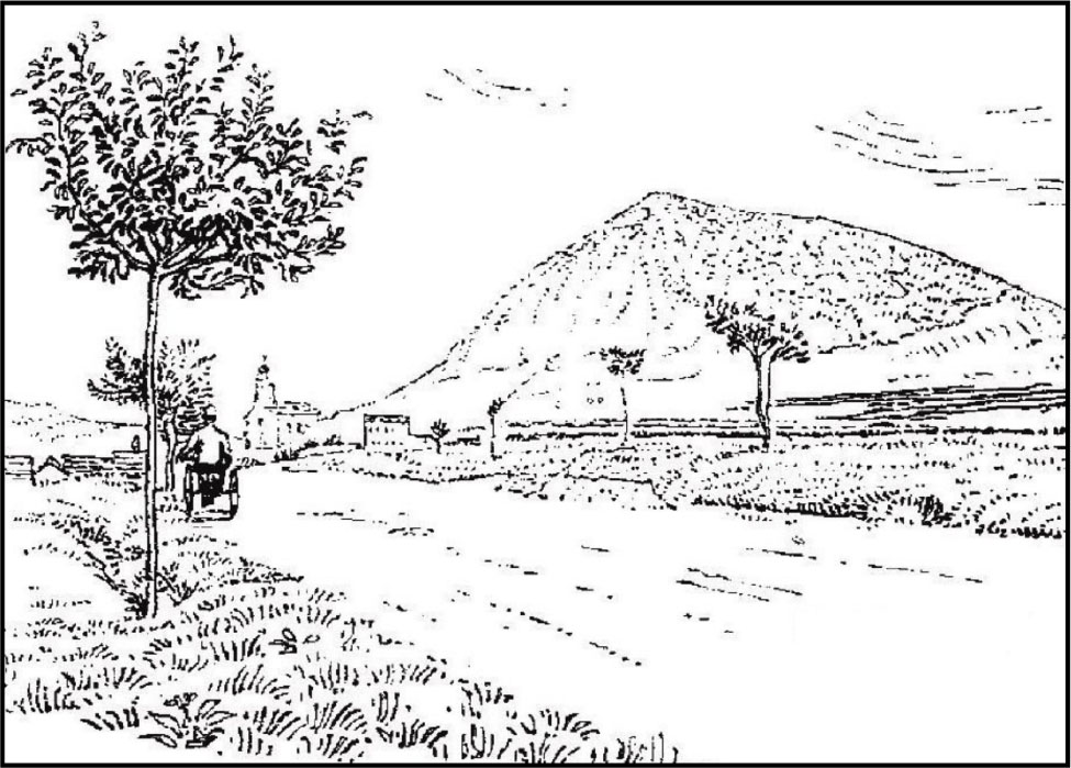
Illustration from The Gypsy Road: a Journey from Krakow to Coblen – A drawing of a hill near Schaldnig, in what is now the Czech Republic, from the 1894 volume by Grenville Arthur James Cole (1859-1924), that could readily be used in modern geotrail interpretative media
1.6 A European Cycling Network
Europe’s cycling renaissance, which began in the late-twentieth century, is supported by the development of local, regional and international cycling route networks. As an underpinning model (Figure 3) indicates these routes along with associated attractions, are an essential element, appropriately promoted, in developing and maintain cycling provision. In the UK, the development of cycling route networks and some attractions, such as interpretative panels, is largely due to the cycling charity Sustrans (from SUStainable TRANSport), established in 1977. Its first completed project was the Bristol and Bath Railway Path, along which some early geo-interpretation (Figures 4a-4c) was provided [46]; its preparator noted ‘Many of these routes follow disused railway lines where rock exposures can still be seen, giving an unprecedented opportunity to promote our geological heritage to the public…’ [46]. Its flagship national project, the National Cycle Network (NCN), with over 22,500 kms of sign-posted routes, was officially opened in June 2000. Whilst about 70% of the NCN is on previously existing, mostly minor, roads it includes converted abandoned railways. Many of its routes are incorporated within local and regional trails. In rural areas where much less motor traffic is encountered it is used primarily for leisure cycling. Only 35% of urban sections’ usage is for leisure purposes, but that represents a significant proportion of local leisure cycling trips, particularly where cycling infrastructure such as the NCN has been developed [34]. A fifth of NCN cyclists are new or returnee cyclists. Half of all NCN trips are by walkers.

The ‘Bicycle Tourism Product Cycle’ Model – This shows the dependency of cycling attractions upon promotion and how cyclists are drawn to them by routes and services/facilities
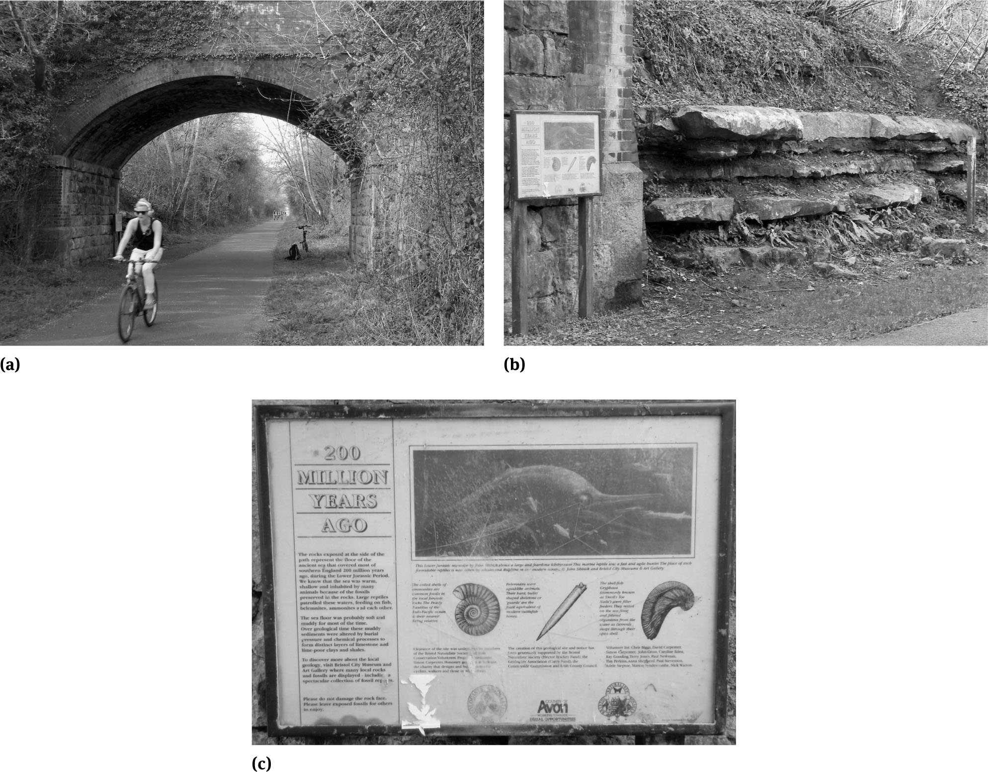
Bristol and Bath Cycle Path
a. Interpretative panel – This panel was erected in 1995 at the Saltford bridge exposure of fossiliferous Upper Jurassic Limestones and shales. The leisure cyclist (and the interpretative panel can be seen over her left shoulder) in the foreground is typical of the users of the cycle path. Beneath the bridge can be seen the author’s small-wheel folding bike used for much of the fieldwork underpinning this paper.
b. Interpretative Panel – At the Saltford bridge, the panel is placed in front of an exposure of Upper Jurassic limestones and shales with their entombed ammonite fossils. However, because the panel does not face oncoming cyclists most do not notice its presence!
c. Interpretative Panel – The panel illustrates the three fossils likely to be found in the local rocks, together with an illustration of an ichthyosaur, and provides some palaeoenvironmental information together with a brief geoconservation message
A mainland Europe international cycle network has developed under the auspices of the Brussels-based European Cyclists’ Federation (ECF), founded in 1983. It is coordinating the development of a 70,000-km 15-route EuroVelo (EV) (Figure 5) cycling network, which should be substantially completed by 2020, to connect Europe’s countries. Supplementary local and regional routes increase its coverage and usage. A national German Cycling Network (Radnetz Deutschland) has 12 long-distance D-Routes (D for “Deutschland”) that either complement or form part of the EV network. The 1019-km D-Route 8, the Rheinradweg (the Rhine Route), forms much of the 1,233-km EV15. The 733-km long D-Route 6, Donauroute (Danube Route), from near Basel to Passau, forms part of the 3,653-km EV6 route, The Rivers Route. It follows the courses of some of Europe’s major rivers from the Atlantic coast to the Black Sea. It includes the Danube Bike Path, stretching from Donaueschingen in Germany to the Danube Delta in Bulgaria, Europe’s most popular holiday cycle route.
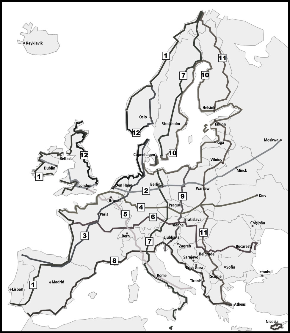
Map of the EuroVelo routes – This outlines the routes (with their numbers) of the pan-European cycle network
Meanwhile, the European Cyclists’ Federation has developed several projects to promote cycling. Of significance to this study is the ‘Silver Cyclists’ Project’, began in late 2015, intended to increase the number of senior citizens undertaking cycling holidays. Using the EV network as its spine, tourist packages for senior cyclists, partly with the intention of encouraging their sense of European identity through international experiences and extending the tourism season are projected outcomes.
2 Methodology
This qualitative study sought to identify the nature and needs of leisure cyclists as geotourists, to recognise appropriate geological/geomorphological and archaeological/historical geo-interpretative themes for them, and to identify case study areas that best demonstrate the potential (due to the volume of published research available for) for geoarchaeological geotourism development at several scales. A desktop study (particularly for internet-only materials), a physical library search and fieldwork underpin this study. It is also informed by the author’s published [8, 47] and unpublished geotourism [48] and geoheritage research. The author’s preparation of a cyclists’ local geotrail [39, 45] provided practical insights into the value of geo-historical material in the development of geointerpretation for casual cyclists.
For the themes and case study areas some geographical, if not temporal, overlap was sought. It was also considered desirable, for geo-interpretative purposes, that the themes had some human-interest element and topicality, preferably with current environmental concerns. Ideally, the themes should reflect aspects of the wider school curricula because cycling geotourists should have at least some, albeit basic, familiarity with the topics included in geo-interpretative provision; limited analysis of existing geo-interpretative media at some of the selected sites was undertaken to assess their efficacy and demonstrate the challenges of providing such materials for cyclists’ geotrails. It was considered essential that sites related to the selected themes, to facilitate the incorporation of geotourism within existing routes, are readily accessible from the NCN, EV and their supplementary networks.
3 Results
3.1 Outline Framework
Following the broad desktop study, appropriate geological/geomorphological (earth science) themes were identified; likewise, the archaeological/historical themes. These were then matched to a series of UK and mainland Europe case studies based around rivers. Rivers were selected because the various cycling route networks rather focus on them; additionally, especially in hilly and mountainous areas, their cycle routes provide gentle inclines especially suited to the physical capabilities of leisure cyclists. The case studies demonstrate that cycling geotourism can be integrated within current cycle paths and routes instead of completely standalone provision.
3.2 The Themes
The most appropriate geological theme selected, partly recognised from previous research [49, 50], is loess because of its widespread occurrence and inherent climate change record of the past two-million years. Its origins have climate change implications which are topical and easily comprehended by the public for geotourism purposes [51]. The most appropriate geomorphological theme selected is rivers (Figure 6), partly because of their significance in loess distribution and research, and because their valleys are natural routeways. The most appropriate archaeological theme linking loess and rivers identified is the loosely termed ‘The Stone Age’. This incorporates three consecutive periods, the Neolithic (4,000-6,000 years ago), the Mesolithic (6,000-12,000 years ago) and the Palaeolithic (12,000-750,000 years ago in Europe, but older elsewhere). The most appropriate historical theme identified is loosely-termed the ‘Romans’ (some 1,550-2,050 years ago) because many of their, especially excavated, sites can be related to rivers and loess. They sometimes used loess to make bricks, tiles and pottery. Their (particularly funerary) monuments and written records provide some human-interest. There are also numerous archaeological sites and museums with some Roman interest across Europe. The Stone Age peoples’ main migration routes, along major river valleys, were later followed by the Romans for trade and military conquest purposes. The geographical overlap of the loess and Romans themes can be readily appreciated on summary maps (Figure 7).
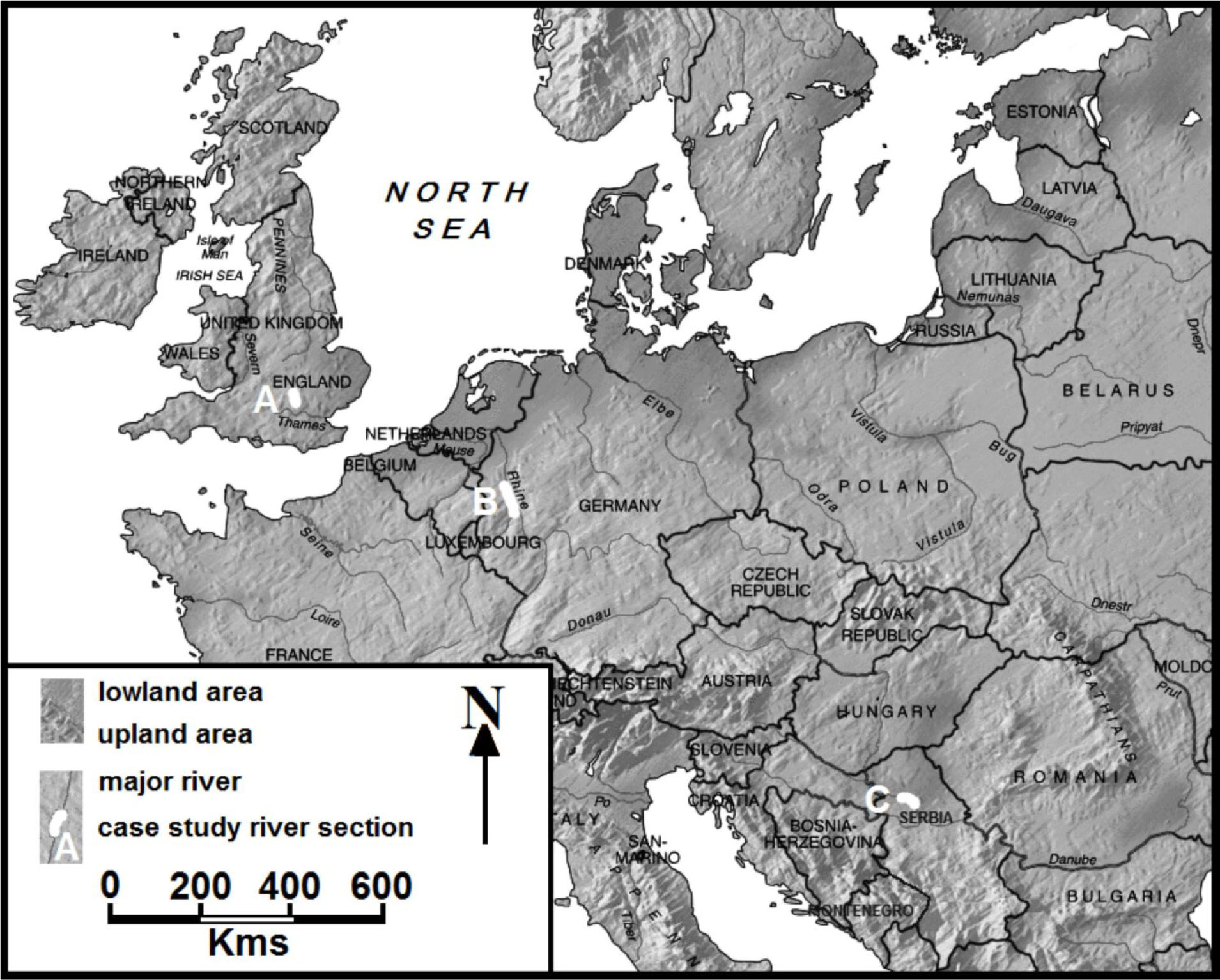
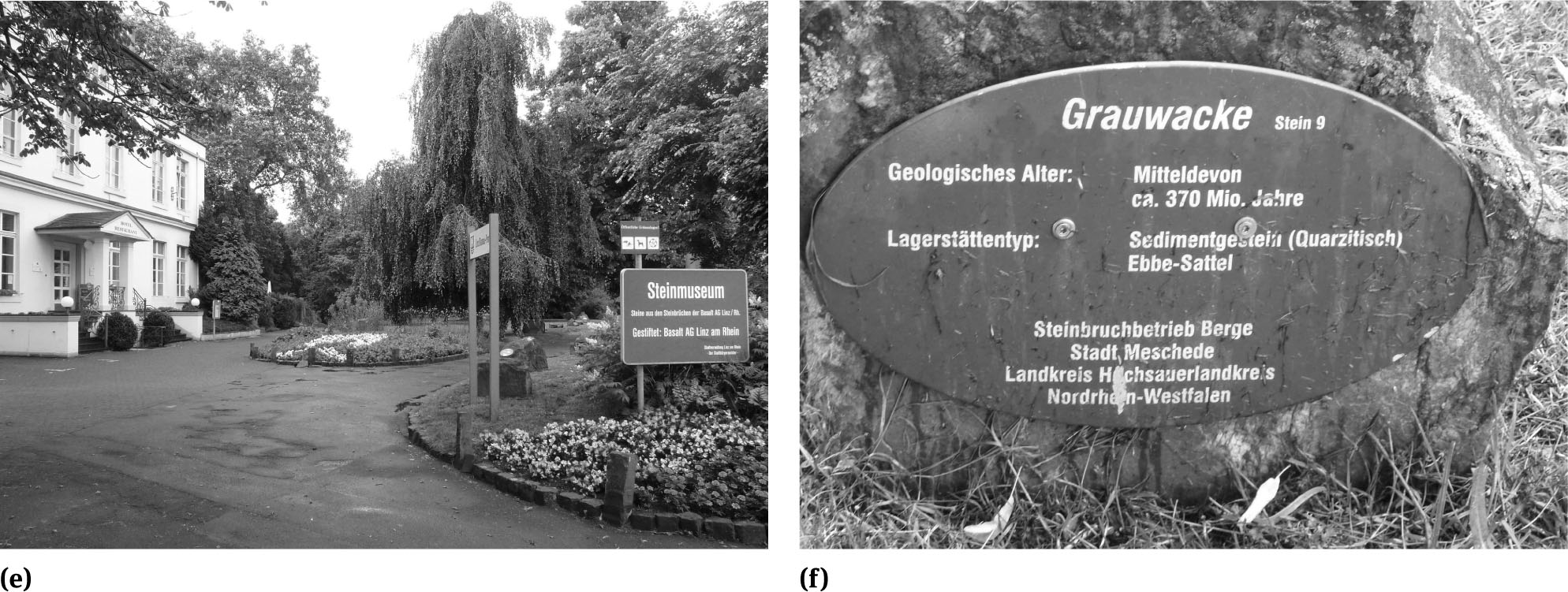
Map of Europe’s Major Rivers – This shows the differences in the scale of Europe’s rivers. It shows the location of the three case study areas, with the selected sections of the Ver, Flit and Great Ouse rivers of Eastern England (A), the Middle Rhine the Upper Danube (C) indicated
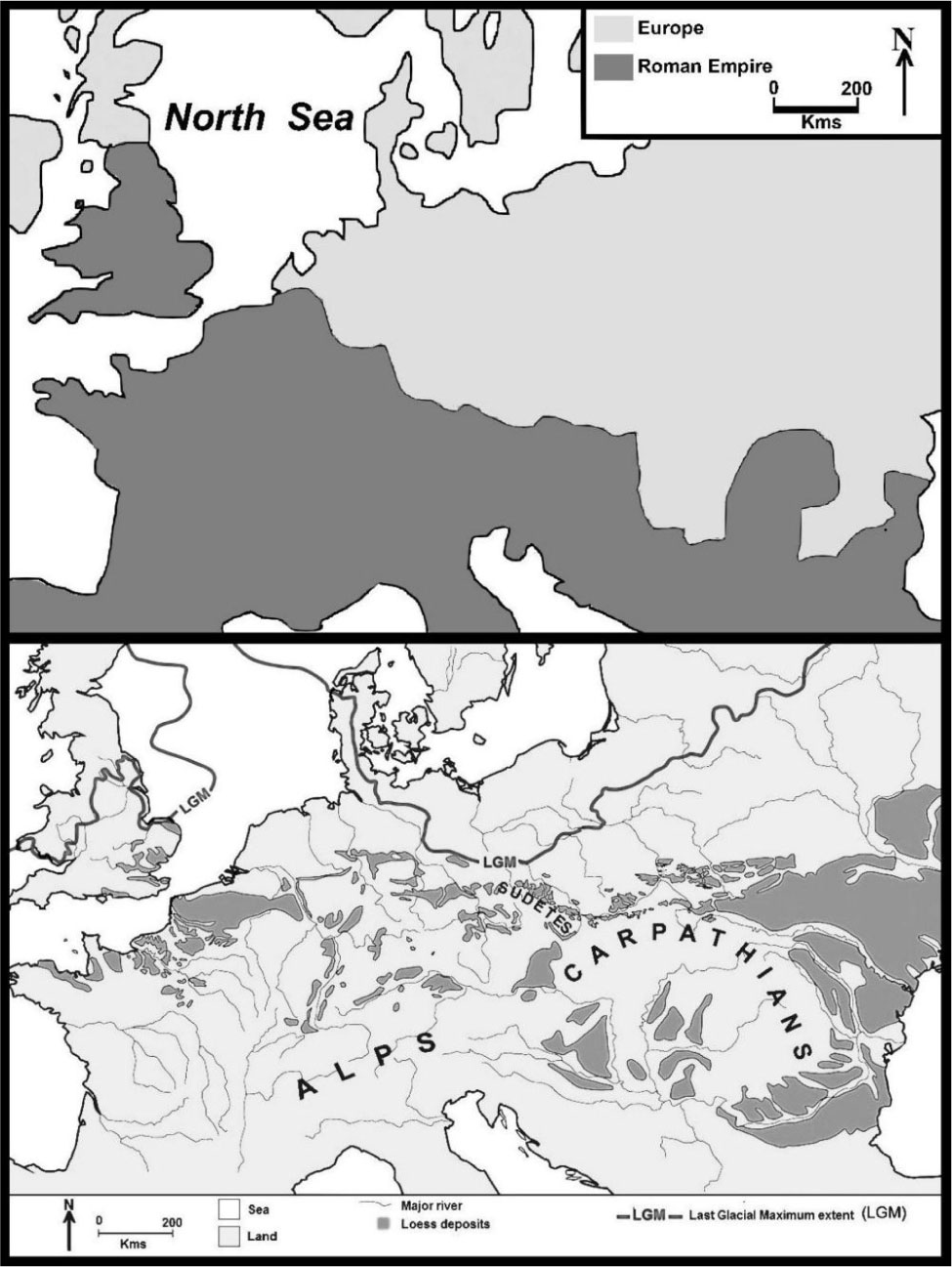
Maps Showing the Geographical Extent the Roman Empire and Loess Deposits in Europe – The Roman Empire, as shown, reached its greatest extent in the 2nd century (around 117 AD, at the time of Emperor Trajan’s death) when it dominated much of northern, central and Mediterranean Europe, as well as the Mediterranean coastlands of North Africa. Thick loess deposits are concentrated, in a broad east-west belt from Britain to the Black Sea. However, where not discretely mapped within that belt it is at least a minor, and usually under-reported, constituent of many soils and river valley sediments
Humankind’s pre-history and the Romans are probably the most universal historical periods with which the public are familiar. The former has gained some popularity with television generated interest in bushcraft (with UK-made but widely networked programmes such as Ray Mear’s Bushcraft), especially when indigenous hunter-gatherers are featured, and in the UK with archaeology television programmes such as Time Team [30]. The Romans is a universally taught subject in junior children’s schools. The Romans have featured in popular major movies (such as Gladiator and The Eagle) and there are numerous well-preserved Roman sites across Europe. The selected archaeological and historical periods are politically neutral. They can be developed and interpreted across Europe without any concern for today’s national boundaries and sometimes volatile ethnic politics.
The German mineralogist Karl Caesar von Leonhard (1779-1862) probably coined ‘loess’ from ‘Loesch’, used by the farmers of the Upper Rhine region for the yellow lime soil ‘Lischen’ or so-called ‘snail-shell soil’ [52]. Loess, silt particles deposited by aeolian processes over extensive areas of the mid-latitudes during glacial and postglacial times, provides a unique palaeoclimatic and palaeoenvironmental terrestrial archive [53, 54] of the of the past 2.6 million years of the Quaternary [55, 56]. Winds picked it up in the northern polar deserts, bordering the ice-caps of the last two Ice Ages, carrying it southward [57] where it accumulated in layers tens of metres thick in mainland Europe but usually much less than a metre in Britain [58]. Also picked up were sand-sized particles; these settled closer to the polar deserts, forming a belt of aeolian sand, sometimes seen as coversands, lying north of the loess belt. Loess is a ‘soft rock’ or even soil sediment [59] but when calcified it supports pseudo-karst landforms such as caves and sinkholes, together with dry valleys, gullies and pyramids [50, 60]. Where loess is particularly rich in clay it is eponymously referred to as “brickearth”. Loess-derived soils till well and were preferred by Europe’s early farmers [61].
Rivers are major erosional land-shaping elements that carry and deposit (as fluviatile sediments) a range of clays, silts, sands and gravels across their valleys. They have provided food and water, transport routes, and settlement sites for humankind since it migrated into Europe around a million years ago, although permanent settlement only began about 500,000 years ago. Pleistocene fluviatile sediments are an important repository for Palaeolithic artefacts, from which a record of early human, especially Lower Palaeolithic hunter-gatherers, occupation can be reconstructed [62, 63, 64, 65, 66]. This is because rivers receive coarse detritus from the landscapes they drain, much of which remains in their valley deposits. Many fluviatile deposits incorporate reworked loess and aeolian sands. Stone artefacts have found their way naturally into these and gravel terrace deposits, whilst other are in them due to human activity such as flint knapping on river beds. Stone Age hunter-gatherers and settlers migrated into Europe from the south and east, following the withdrawal of the Ice Age glaciers.
The Palaeolithic coincides almost exactly with the latter half of the Pleistocene epoch (2.6 million years to about 12,000 years ago) by the end of which Britain was separated from mainland Europe by the creation of the North Sea and the English Channel. It was period of great geographical changes (particularly in coastlines and the courses of major rivers) marked by major cyclical climatic fluctuations and sea levels changes; these affected human expansion, settlement, hunting and farming activities across Europe. Stone Age peoples made practical use of implements fashioned from a limited range of rock types, trading them over great distances. They settled on loess-derived soils because they were easy to till with unsophisticated farming implements and techniques. The last Stone Age migrants left a rich archaeological record, particularly along its major rivers and strategic hill tops. Linking a very few of the Stone Age sites is the Bonn based ‘Ice Age Europe Network of Heritage Sites’ [67], established in 2013 with 15 archaeological sites and their affiliated museums and visitor-centres as founding members. Its foundation indicates that there is an opportunity to develop geotourism resources for geoconservation linked to the geoarchaeology of loess areas.
The Romans expanded their influence and control through trade, settlements and military campaigns, with their empire’s greatest consolidated extent in the 2nd century (around 117 AD, at the time of Emperor Trajan’s death). Its empire dates from when Ocatavian became Emperor Augustus until its fall to the Goths (marking the end of the Ancient World and the beginning of the “Dark Ages”), in 27 BC and 476 AD respectively. Many of the empire’s most productive farming areas, often the archaeologically richest, were on loess-derived soils. Roman buildings were constructed with locally manufactured bricks and tiles, sometimes made from ‘brickearths’ - as was some pottery. The Romans introduced viticulture across Europe; some of the Danube, Moselle and Rhine valley vineyards are on land they first cultivated. Many of the major routeways and their settlements established by the Romans are still in use.
3.3 The Case Study Areas
Several loess areas, associated with rivers and Stone Age/Roman sites were identified, partly on their accessibility to the author and his research colleagues, in three principal regions:
Central eastern England (particularly the Great Ouse).
Northern Europe (middle valley of the Rhine),
South-eastern Europe (the Danube in Serbia).
Within these, potential geotourism sites were identified for consideration on rivers of three loosely defined magnitudes:
Local - Ver (Caddington and Whipsnade) and Flit (Flitwick) rivers.
Small Regional - Great Ouse (Biddenham).
Great Regional and International - Middle Rhine (Bad Honningen, Ariendorf and Andernach) and Middle Danube (Stari Slankamen and Kostoc).
4 The Case Studies Explored
4.1 Central Eastern England
The rivers, respectively in order of length and drainage area, Flit, Ver, and Great Ouse, in central eastern England (Figure 8a), are in a region with loess of mainly Late Devensian age, subjected to late Devensian periglaciation (evident in some river terrace sections) with parts also subjected to the full Anglian glaciation. A south Essex and Hertfordshire loess province has been particularly recognized [68]. In north-east Hertfordshire loess is mainly found in river valleys. Little loess lies where it originally fell and is unaltered. Most has been re-deposited locally by downwash on valley sides, admixture with other deposits through cryoturbation, and further afield by rivers. Maps of the region’s loess deposits do not imply their uniform thickness and continuous cover; at least half of its soils contain either a distinct loess layer 0.3+ m thick, or an equivalent amount mixed with other deposits. It is almost ubiquitous on the Chalk downlands. Loess is indicated as such on maps of the Soil Survey of England and Wales. On British Geological Survey maps it is shown as “brickearth”, “head brickearth”, “river brickearth”, or even “loam”; not all are either pure loess or contain loess. Rarely, it contains the bones of steppe and tundra animals such as mammoth, woolly rhinoceros, reindeer, and voles.
Central Eastern England
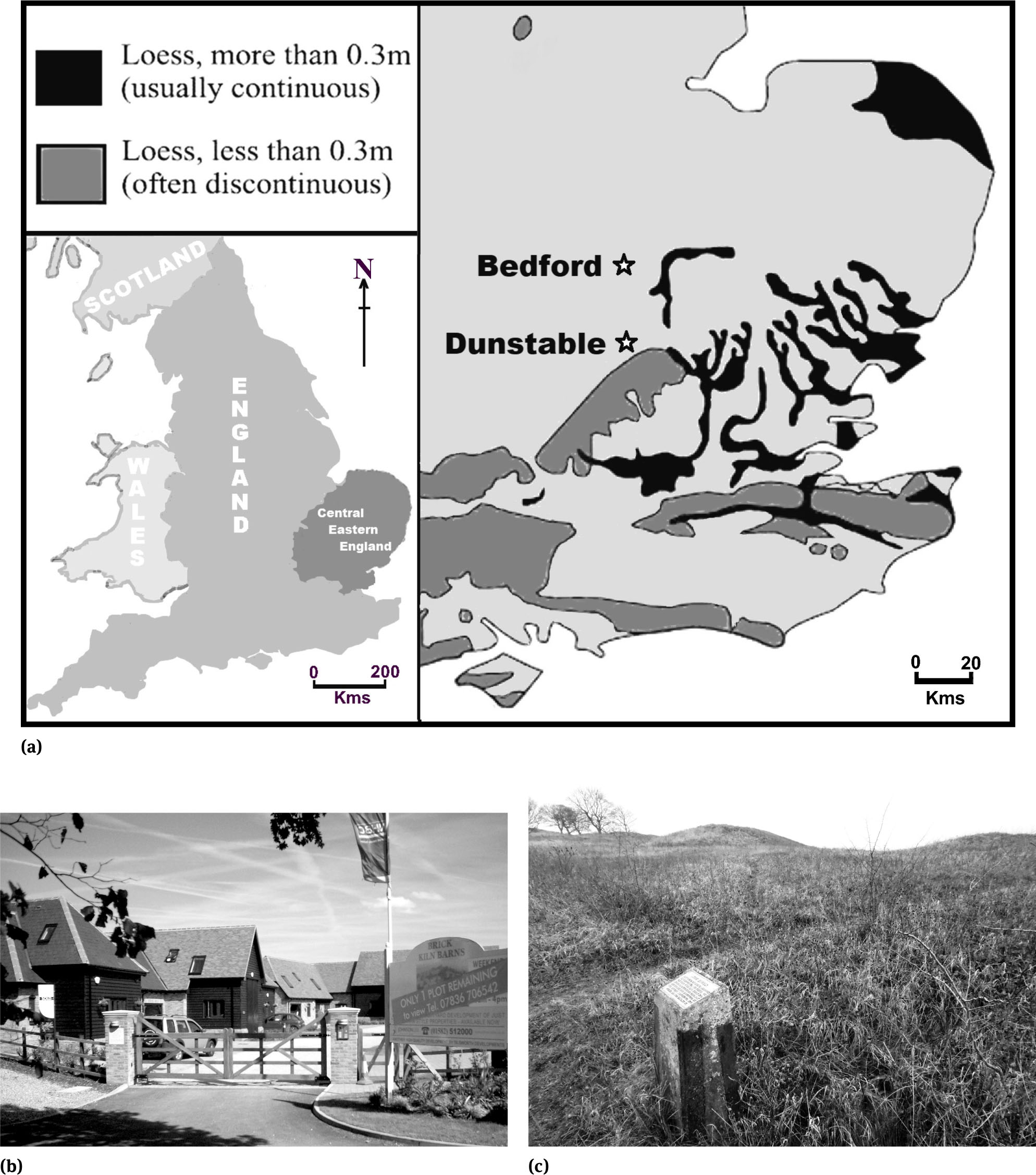
a. Map of major loess deposits in Central Eastern England – Whilst loess deposits can be found across, although probably considerably under-reported, much of England and Wales they are often very thin and incorporated within soils. Thicker, up to about 2-m loess deposits can be found in eastern England, especially in a few coastal sections. Equally thick loess deposits were excavated, as ‘brickearth’, in Chalk dolines around the Whipsnade area just south of Dunstable whist loess is a minor constituent of some of the River Great Ouse sediments at least in the Biddenham area, west of Bedford.
b. “Brick Kiln Barns” private housing estate – This 2010s development has been built over a nineteenth century brickyard and kiln site; amazingly, when the author was undertaking fieldwork on the site he found that none of the residents were aware of the site’s geological or industrial archaeology interest!
c. The Five Knolls, Dunstable Downs – This has seven barrows, or burial mounds, and was used for burials from late Neolithic to Roman times. The metal plaque atop a concrete post, probably dating from the late-1950s, provides basic site information; it is the only one of several such remaining intact on the site and will probably outlast the fibreglass interpretative panel emplaced in the 2000s.
Central Eastern England
d. St Albans, Roman town walls – The incomplete remains of the town wall of Verulamium stand up to 4m in height with each major section having a small information panel. The walls consist of cemented local flint rubble, with locally-made red tile coursing. Just off the town lies the site museum and an amphitheatre.
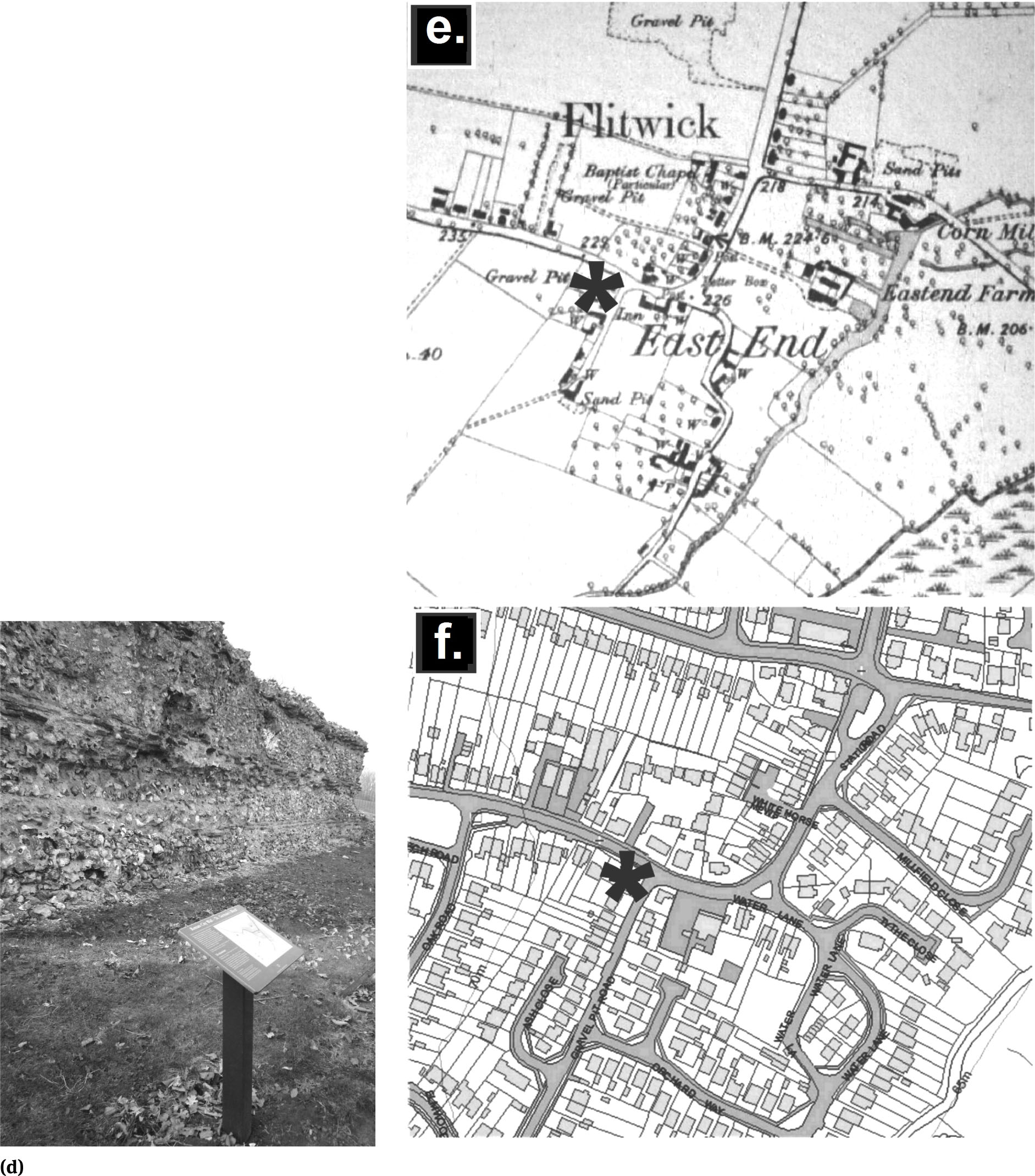
e. Flitwick, late 19th C. OS 1:12,560 map extract – This shows two gravel pits (the asterisk marks the position of one of them) and a sand pit, together with part of Flitwick Moor - shown as hummocky grass with trees. © Ordnance Survey
f. Flitwick, early 21st C. OS map extract – The street map extract (reproduced to the same scale as 8e) shows in some detail how almost the entire late-19th C. rural landscape, including parts of Flitwick Moor (shown bottom right, that is the south-east corner, on both map extracts), has disappeared under relatively modern housing developments. However, the existence of the old gravel pits is marked by road names – the asterisk marks the entrance to ‘Gravel Pit Road’. © Ordnance Survey
Central Eastern England
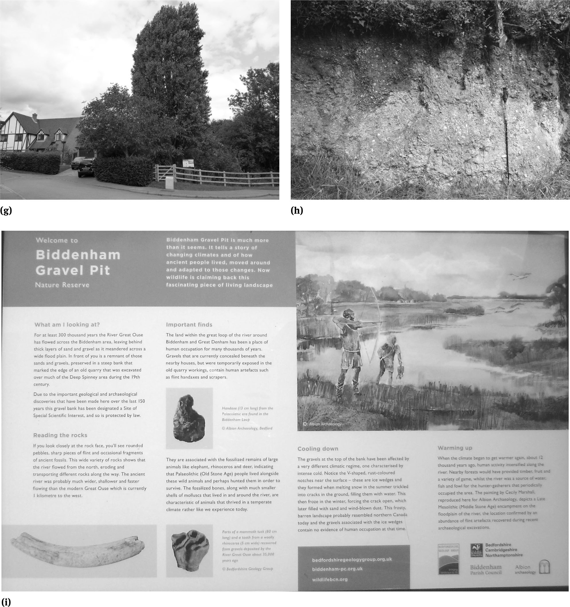
g. Biddenham Pit, the entrance – The entrance to the pit, via a usually locked gate, is to the left of the interpretative panel and off an upmarket private housing estate cul de sac. The pit, in a hollow below the fencing, is somewhat overgrown, a common problem with such Quaternary sites.
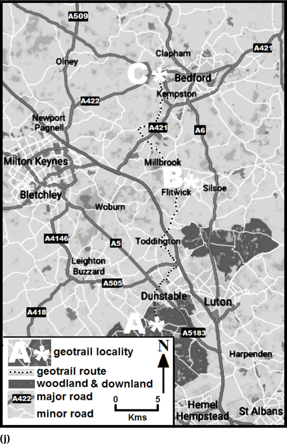
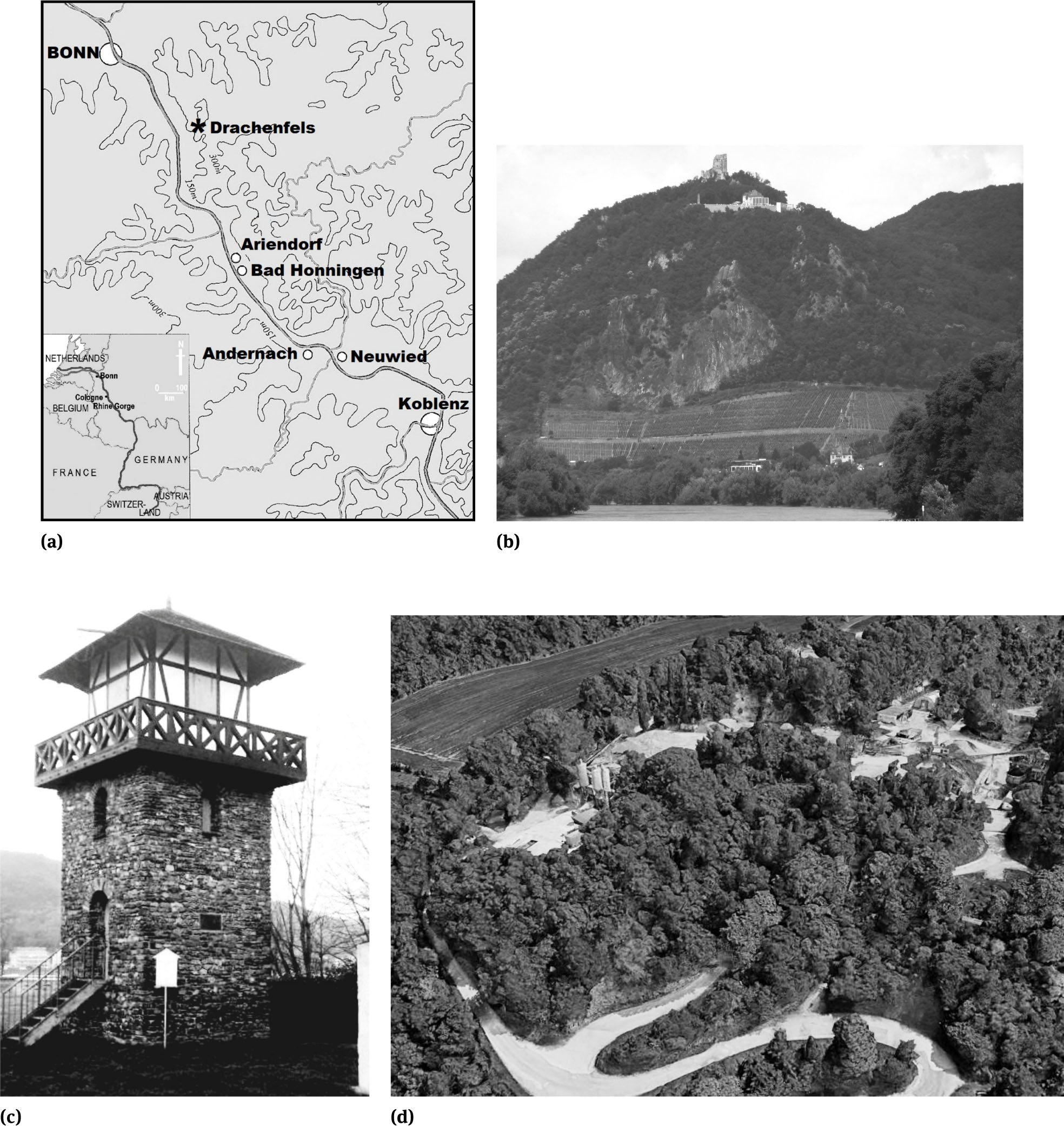
h. Biddenham Pit, the main face – The gravels at the top of the exposed face show the relict effects of periglacial conditions. The large v-shaped dark notch (top left) is an ice-wedge. Its outline has been preserved by wind-blown sand and dust (loess). The walking pole, used for scale, is 1.2m long. i. Biddenham Pit Geo-Interpretative Panel – The panel is noteworthy for its geoarchaeological theme of river dynamics, the Stone Age and climate change
Central Eastern England
j. Map of the Proposed Whipsnade to Biddenham Geotrail route – This links the existing Flitwick (B) geotrail with two others currently in preparation for the Whipsnade (A) and Biddenham (C) areas; all are based upon historical Geologists’ Association excursions. (Map based upon a © GoogleMaps original)
There are ‘…important deposits of Palaeolithic material notably in the Great Ouse valley and brickearth deposits in the Chilterns. However, most of these finds were made in the 19th or early 20th centuries during the excavation of gravels or “brickearths” [69]. Hence, ‘There is considerable value in re-examining sites that have been productive in the past; especially where archaeologically important deposits have survived mineral extraction.’ [69]. The Lower and Middle Palaeolithic legacy archaeological record suggests the areas with greatest potential for new sites are the Ouse Valley gravel terraces and the Chilterns loess deposits. The Upper Palaeolithic is seemingly not represented, perhaps reflecting archaeologists’ lack of awareness and understanding of the nature of the period’s representative artefacts. Sealed, and currently unexploited or unexcavated near-river sites and valley deposits offer the most likely places where Upper Palaeolithic material might be found [70].
Most Mesolithic sites have been identified from surface collection. Its likely locations are rivers valley, good vantage points and high routeways - principally the Chilterns and the Greensand Ridge. Its three principal localities include the Biddenham Loop. The paucity of Mesolithic sites might also reflect archaeologists’ lack of awareness and understanding. Neolithic archaeology is patchy in distribution and context. Settlement remains are rare; the evidence is often ephemeral, difficult to identify and interpret, reflecting the nomadic nature of the ‘settlers’. Artefacts associated with domestic sites are mere near-surface flint scatters. This is generally characteristic of Palaeolithic to Mesolithic sites, but the older sites have often been covered by river silts and gravels. Recorded ceremonial and burial monuments are relatively numerous because they are obvious as ground features and in aerial surveys; they are focused on river valleys, mainly the Ouse and Ivel, and the Chilterns. Some of the significant archaeological sites are statutorily protected; for example, Gaddesden Row [71] and Biddenham’s Deep Spinney Pit [72, 73, 74] as geological Sites of Special Scientific Interest (SSSI). A circular cyclists’ geotrail, based on a GA 1905 excursion, for the Flit was prepared in 2017 [39, 45].
4.1.1 The River Ver: Whipsnade and Caddington Lower Palaeolithic sites
The general nature of the Whipsnade area’s loess was first scientifically described and analysed in the early 1960s [75] and later in the early 1980s [76]. Significant loess sites with Stone Age archaeological interest were unearthed in the nineteenth century in and around the River Ver. A 27-km linear, mainly walking, route from the river’s source to its confluence, after flowing through St. Albans, with the River Colne is supplemented by eight circular walks, one of which [77] passes some of the Whipsnade geoarchaeological sites. In the nineteenth century these brickearth pits yielded significant early human occupation finds [78, 79]. Two were excavated, at Caddington and Whipsnade itself.
Caddington’s nineteenth century brick manufacturing site is preserved in the modern name “Brick Kiln Barns” (Figure 8b) of a 2009 housing development. The Palaeolithic and Neolithic finds were generally found beneath gravels overlying material derived from loess accumulated in dolines within the Chalk. The artefacts from these early excavations and other sites, in the several brickyards around Dunstable and Hemel Hempstead, were illustrated, interpreted and popularly described by their excavator, Worthington G. Smith (1835-1917), in 1904 [80]. In 1886 Smith had found several Palaeolithic artefacts associated with the River Lea in Luton, Harpenden and Wheathampstead. He continued observations in the area, finally in 1888 finding his first in situ implement at a Caddington brickpit, illustrated [81] in his book Man the Primeval Savage. He particularly mentioned the Caddington sites, with detailed descriptions of their geology and natural history, in his book. Smith first recorded Palaeolithic archaeology in September 1896 at ‘Whipsnade’, although the site was in Kensworth. The true Whipsnade site was not discovered until January 1913, when a single hand-axe was recovered. Smith died before he published his findings, but Reginald Smith (of the British Museum) gave a later published report [79], using Smith’s notes and illustrations, to the Society of Antiquaries. Smith’s other important site was Butterfield Pit at Gaddesden Row.
Smith worked these sites, maintaining contact with their owners and workers to ensure finds were reported to him, over some 20 years. Being brick-pits, they were ephemeral, generally backfilled and even built over, making it very difficult to locate them today. Even Smith records this problem for the Caddington sites where in 1890 he found ‘…when the winter arrived the brickyard was abandoned, the excavations filled in, and the place ploughed up and planted with corn.’ [81]. Smith’s Man the Primeval Savage [81] became a classic text. Relevant to geoarchaeology, its Preface recorded ‘An effort has been made to present…a few results of research into the nature and surroundings of primeval man, as deduced from geological, anthropological and archaeological evidence.’ [81].
In the twentieth century’s final quarter, Smith’s excavated sites were reassessed by archaeologists [71, 82, 83] and geoscientists [84, 85, 86]. At Whipsnade ‘The exact location of the brick-pit… proved difficult to determine as the pit has been backfilled and landscaped, with few traces of its original outline visible on the restored land surface.’ [86]. Its re-examination failed to find any significant quantities of loess and artefacts. In 1975 a test section in the Butterfield Pit unearthed a small number of in situ flint flakes and a hand-axe.
Just 3 kms to the north of the Whipsnade sites, on the Dunstable Downs (part of the Chiltern Hills), is the Five Knolls (Figure 8c) where seven barrows mark a burial site used from late Neolithic to Roman times; its new interpretative panel, unlike the old informational plaque, does not mention the Neolithic. The site was first recorded in the eighteenth century by the famous English antiquarian William Stukeley (1687-1765). It was partly excavated in the 1850s and 1920s. All the southern Bedfordshire river sites are within 20 kms of St. Albans (Verulamium) with its upstanding remains (Figure 8d) of a major Roman town and its dedicated Roman museum. Dunstable (Durocobrivis), although nothing is visible above ground, was a small Roman settlement. The Whipsnade area sites can be accessed from several local cycling routes. A new cyclists’ geotrail, partly based on the route, although its excursion report was never published in the PGA some details were in its GA Monthly Circular notice, of an 1894 GA excursion, is in preparation.
4.1.2 The Flit: Spa Water, ‘Gold’ and Sandstone along the Flit
Midway between the Whipsnade and Biddenham Palaeolithic sites lies the main valley of the River Flit which flows into the River Ivel, a tributary of the River Great Ouse. Several modern, but outdated in their stratigraphy, publications ([87, 88, 89, 90], together with the BGS publications [91, 92], summarise the area’s geology. Four GA excursions [93, 94, 95] were made to the area of which one [96] included a cycling party.
The 1905 Flitwick cycling excursion, reflecting the lack of Stone Age archaeological finds and research focus at the time, was primarily focused on Lower Greensand geology. Minor Mesolithic finds have been made in the area near Clophill [97]. None of the sections within Flitwick observed by the 1905 excursionists survive. One off the appositely named Gravel Pit Road was lost to housing estates in the late 1950s and 1960s. Other pits were lost from the late-1970s onwards under a housing estate and a school. Because their position is retained in road names (Figure 8e-8f) they are potential geo-historical trail sites. Elsewhere along the excursion route the old quarries are sometimes preserved in the gardens of houses built from the 2000s onwards. Flitwick Moor where ‘Most of the members tasted the water … found to be strongly impregnated with iron and vegetable acids.’ [98] is accessible, although the site where its water was commercially bottled from around the 1860s to 1938 has gone.
The engaging style of the excursion report, unlike most modern geological accounts, has some appeal to modern casual geotourists. The historical and modern stratigraphical accounts, supplemented by the published reports of GA excursions provided the comprehensive underpinning [39] for a circular cyclists’ geotrail based on the 1905 Flitwick and Silsoe excursion report [99]. The cyclists’ geotrail pdf file, to avoid the necessity of on-site panels but with the possibility of affixing Quick Response (QR) code labels to existing panels and signs, is designed to be both printed and displayed on smart-phones and tablet computers; it is posted on the GeoConservationUK website in its trial form, with the intention to move towards an interactive version in the future. It follows much of the original route, only deviating where modern traffic would make it dangerous. It can be joined from the NCN route 51 just 5 kms to the north.
4.1.3 The Great Ouse: Biddenham Lower Palaeolithic sites
Some 30 kms to the north of Whipsnade, within the Great Ouse valley, lie two sand and gravel pits at Biddenham, 5 kms west of Bedford. Unfortunately, the archaeological accounts and reports for these pits, especially from the nineteenth century, confuse them. Their river gravel terraces with inter-bedded silts and clays have yielded significant Palaeolithic artefacts and Pleistocene large mammal bones and molluscs. James Wyatt, a Bedford-based antiquary, collected the first Palaeolithic flint implements ever found in the UK when he made the Biddenham Pit ‘…the object of almost a daily pilgrimage. After a search, continued for many months, he has at last been rewarded by finding two well formed flint implements…’ [100]. Excited by his discovery Wyatt swiftly reported it to eminent members of the Geological Society of London. Within days he was visited by noted geologists and archaeologists of the time, Sir Charles Lyell, John Prestwich and Sir John Evans. The geology [101, 102] and archaeology [103, 104], of that first small Biddenham Pit (Figures 8g-8h) was initially described in the nineteenth century. Now part in-filled, overgrown by scrub and woodland, it lies unmarked and unremarkable in a major new housing development and opposite its better-known and preserved rival on the other side of the Bedford to Northampton road. However, its impact on geoarchaeology’s development was significant. Sir John Evans (1823-1908), who had swiftly visited the site was a Hertfordshire geologist and archaeologist who pioneered the correlation of Britain’s Pleistocene geology and the activities of early humankind. When awarded, in 1880, the Geological Society’s Lyell Medal its President paid him the accolade ‘We can now scarcely say where archaeology ends geology begins, nor whether to rank and value you most as an antiquary or a geologist.’ [105].
Much of the focus of excavation and recovered finds quickly shifted from the small Biddenham Pit to the much larger Deep Spinney Pit, now (and confusingly also) referred to as Biddenham Pit. Many Lower Palaeolithic hand-axes [106] and the remains of large Pleistocene mammals [107] were unearthed at the pit in the nineteenth century. Twenty-two mollusc species were recorded from it in 1922 [108]. Over 150 years it has yielded many hand-axes, a single bead, a single flint core, and large quantities of flint flakes and stone implements, together with various Pleistocene mammal bones and almost 50 species of molluscs, indicative of an interglacial episode. The Pit was reassessed in the late-twentieth century by archaeologists [74] who confirmed it still had significant Pleistocene deposits and Palaeolithic artefacts. Isolated Palaeolithic stone tools were recovered during extensive archaeological investigations in the Great Ouse’s Biddenham Loop [109] which encompasses the site. What remains of the Pit, most having been covered by a private housing estate in the 2000s, is a SSSI and a designated Geological Conservation Review site for its Quaternary interest. Owned by the housing estate developers, management advice is provided by Natural England. Conservation is undertaken by the Bedfordshire Geology Group, an amateur geoconservation group, which had some input into its geoarchaeologically themed interpretative panel (Figure 8i).
This was analysed employing techniques developed [48] and part-published [110, 111] by the author for research into geo-interpretative media’s efficacy. Its text had an overall readability (with a Flesch Reading Ease of 41, and a Flesch-Kincaid Grade Level 15) in the difficult category, requiring a university education for full and easy comprehension; some of the texts were best suited to postgraduate level readers. As such, it is less intellectually accessible than the mid-1990s panel still on the Bristol and Bath Railway Path at Saltford bridge with an overall readability (Flesch Reading Ease 49.5; Flesch-Kincaid Grade Level 10.8) of around 16 years. Both would benefit from some rewriting; for example, from the texts on the Biddenham Pit panel:
‘The land within the great loop of the river around Biddenham and Great Denham has been a place of human occupation for many thousands of years. Gravels that are currently concealed beneath the nearby houses, but were temporarily exposed in the old quarry workings, contain human artefacts such as flint handaxes and scrapers.’ [Word count 53 / Flesch Reading Ease 43 / Flesch-Kincaid Grade Level 14].
can better be expressed as:
‘The land around the villages of Biddenham and Great Denham, within a great loop of the river, has been lived on by people for many thousands of years. Flint hand-axes and scrapers were found in the gravels, on which the houses you can see were built, in the old temporary quarry workings.’ [Word count 52 / Flesch Reading Ease 62 / Flesch-Kincaid Grade Level 11].
The Biddenham Pit panel’s typography consists of 37% white space, 30% text and 33% illustrations which places it outside of both the ideal and acceptable ranges; likewise, for the Saltford bridge mid-1990s panel’s typography of 44% white space, 24% text and 32% illustrations. However, whilst the older Saltford bridge panel is a single themed design the Biddenham Pit panel is effectively split into two distinctive halves, a panel most visitors would not consider visually appealing. Whilst the panel’s authors are to be commended for at least tackling a complex geoarchaeological theme, in covering so many topics they have created a book page on an outdoor panel; the text analysis supports that conclusion. This new and the Saltford Bridge panel, and their communicative competence shortcomings, are not exceptional examples in the regions considered in this study.
4.1.4 Whipsnade to the NCN 51 as a Cyclists’ Geoarchaeological route
The proposed geoarchaeological cyclists’ geotrail has sufficient Stone Age and loess sites to merit its development. However, the major Roman site of Verulamium is difficult to easily and safely, due to the traffic on the local roads, link to the other River Ver sites and Whipsnade, but some consideration could be given to a St. Albans-centred geotrail. Meanwhile, an outline linear geotrail linking the Whipsnade, Flitwick and Biddenham sites (Figure 8j), using the A5120 and B5120 Dunstable to Bedford road as the spine route, is already in development; individual parts of it will also be used for the two new circular geotrails near Bedford (for Biddenham) and Dunstable (for Whipsnade and the Five Knolls) due for initial trialling in 2018.
The Middle Rhine Sites
a. Map of the Middle Rhine localities – This map indicates the broad topography of the Rhine valley in the area and shows the main sites mentioned in the case study. (base map is after Turner 1997)
b. The Drachenfels – The 321-m hill on the banks of the Rhine in the Siebengebirge uplands was formed by rising magma that did break through to the surface; it cooled and solidified to form trachyte which has been quarried since Roman times. The hill’s slopes have the most northerly vineyards along the Rhine
c. Bad Honningen, reconstructed Roman watch tower – This is of stone construction although many of the watch towers were of timber construction, matching the mainly turf and palisade nature of the Roman defensive lines
d. Bad Honningen, aerial view loess pits – A grading and washing plant can be seen in this view of the main working loess pits (modified image, Courtesy of Google Earth)
The Middle Rhine Sites
e. Linz am Rhein stone museum – The entrance to the park setting of some twenty or so labelled stones that represent the local solid geology
f. Linz am Rhein stone museum – Each of the stones, such as this Middle Devonian greywacke, is clearly numbered and labelled with its type, geological epoch, age and original location
4.2 The Rhine Valley
4.2.1 The Middle or “Romantic Rhine”
The 1,232-km long River Rhine connects the Alps to the North Sea. Its “Middle Rhine”, between Bonn and its confluence with the Moselle at Koblenz, is one of four major named sections (the others being the High, Upper and Lower Rhine) of the river between Lake Constance and the North Sea. Passing through it is part of the 1380-km dedicated cycle route, EV15 [112]. The Rhine valley’s loess deposits are up to 30 m thick, but they are usually much thinner. It covers the early human, often ephemeral, occupation sites, preserving them and any bone material. The valley is a natural routeway and was exploited for early hominid expansion into north-west Europe. During the Middle Palaeolithic (some 30,000 to 100,000 years ago) it, and the Danube valley, was occupied by Neanderthals who developed the Mousterian stone tool culture. The Rhine was then flowing through tundra country across which the Neanderthals hunted big game, such as rhinoceros and woolly mammoth. In the Mesolithic, it was occupied by Cro-Magnon hunter-gathers with a larger and more sophisticated tool kit and a better knowledge of plant foods and uses than the Neanderthals; they might have been primitive pastoralists.
Modern humans settled in the Rhine valley from at least the Iron Age. When the Roman constructed the Rhine Valley Road between Mainz and Cologne it became a major Roman route-way from the mid-first century BC to around 400AD. Then Rhine’s left bank formed the Roman Empire’s eastern border. Roman fortresses were sited at Bingen (Bingium) and Koblenz (Confluentes, named because of its confluence with the Moselle). The upper half of the Middle Rhine (the Rhine Gorge) from Bingen to Koblenz is a UNESCO World Heritage Site. It has over 40 castles and fortresses dating from the Middle Ages, together with many wine-villages, some of which can trace their origins to Roman times. The lower half of the Middle Rhine, from Koblenz to Bonn (Figure 9a), is famous for the volcanic Siebengebirge hills, especially the popular tourist attraction of the Drachenfels (Figure 9b). The Middle Rhine’s many hill-top castles, vine-covered hills and medieval settlements led to the “Romantic Rhine” epithet, a major tourist attraction since the nineteenth century.
4.2.2 The Bad Honningen quarries and other geological interest
At Bad Honningen remains of the “Limes”, the Roman empire’s frontier defensive system, have been used as the basis for a 1972 reconstruction of a watch tower (Figure 9c) near the Limes Centre museum. Whilst Bad Honningen is an important loess locality, the classic loess profile is at Ariendorf, roughly mid-way between Koblenz and Bonn [113]. The site, the Karl Schneider Gravel Pit, on the river’s right bank close to Bad Honningen (Figure 9d), is well described in the INQUA 1995 conference field-guide [114] and elsewhere [115]. Its Devonian age rocks are directly overlain by a 30 m of Middle Terrace Rhine gravels, which in the upper part includes a weathered cryoturbated pumice layer. Higher in the section a soil formation contains two further pumice layers. Atop this are four loess-palaeosol sequences, representing four glaciations. The loess has scattered horse, red deer, bison, woolly rhinoceros and mammoth bones [114]; a possible, but disputed [114], dwelling has also been found.
Some other geotourism interest at Bad Honningen is the small riverside park with 17 different rocks demonstrating the geological variety along the Rhine. These rocks vary from some 460 million years old (number 5 from the Kinzig Valley) to those some 350,000 thousand years old (numbers 12 and 13 from the nearby eastern area of the Eifel). Linz am Rhein, just 7 kms to the north of Bad Honningen, has a similar “steinmuseum” (Figures 9e-9f) with some 21 specimens.
4.2.3 The EV15 as a Cyclists’ Geoarchaeological route
The Rhine Cycle Route, EV15, is on the opposite bank of the river to Bad Honningen, the starting point of the Limes Cycle Route. It easily links the significant loess sites and other geological sites, such as the Drachenfels and Andernach geyser, with the Roman sites. The main German 550km section of the way-marked Limes Route runs from Bad Hönningen to Regensburg. A UNESCO World Heritage site encompassing more than 70 towns and villages, together with excavated sites, forts, reconstructed towers and museums, its minor Roman interest includes 900 watch towers and 120 sentry posts. The chief Roman sites along the proposed roughly 55-km geoarchaeological cyclists’ geotrail Bonn to Koblenz are varied in nature and are summarized below.
Bonn is partly built over Roman fortifications and a town. The first fort was constructed in 11 BC and probably garrisoned by auxiliary troops, guarding the river crossing; according to the Roman historian Publius Annius Florus, there was a bridge across the river. However, after the disastrous battle in the Teutoburg Forest (9 AD), in which the Romans lost three legions, a large legionary base was built to the north of the first fort, as part of the Rhine Limes to guard the newest Roman frontier. This new fortress was initially occupied by the First legion Germanica. After the Batavian revolt by local Germanic tribes, of 69-70 AD, Bonn was rebuilt in stone and became the base of XXI Rapax. After 83, the I Minervia became the garrison legion until the end of the Roman period, although in 101-106, when it took part in Trajan’s Dacian War (101-107 AD), some of the XXII Primigenia acted as a caretaker garrison. The excavated tombstones and votive stones have provided the names and some of the backgrounds of around 200 legionaries who mainly belonged to the the I Minervia. A settlement of craftspeople was established shortly after the first fort; this mainly lies under today’s Adenauerallee to the northern end of the Rheinauenpark in the Gronau borough. A series of residential buildings, shops and a temple complex were discovered in the late 2000s. The Roman Cellar at Haus der Geschichte Bonn displays a range of outstanding local artefacts, including a particularly fine carved ivory knife handle in the form of a gladiator and typical Samian ware pottery.
Andernach, 45 kms upstream from Bonn, was founded by the Romans as Porta Antunnacensis and was a significant trading town. The medieval St. Mary’s Cathedral is built over the Roman settlement; building works there in 2006 revealed a Roman bathhouse, now a tourist attraction. Above the village is the world’s highest, at 50-60 m, cold-water geyser. Whilst Neuwied, 12 km from Koblenz, was only founded in the mid-seventeenth century as a new town, nearby is the largest Roman castrum (fortified military camp) on the Rhine. Koblenz was a strategic Roman site from 9 BC with the construction of the military post, Castellum apud Confluentes (fort on the river confluence); some limited Roman remains are still visible in the city.
Thus, the proposed geoarchaeological cyclists’ geotrail (for which a university partner is currently sought for development in 2019), employing parts of the Limes Cycle Route near the Rhine but mainly the EV15, has sufficient Roman, loess and other geological sites to merits its development. Bad Honningen is a summer stopping point for ferry and cruise ships on the Rhine making it, and the proposed geotrail, readily accessible to leisure cyclists looking for shorter half-day and day-routes.
4.3 The Danube
4.3.1 The Middle Danube
The Danube’s middle section is entirely navigable, with popular tourist cruise routes between Belgrade and Novi Sad and upstream to Budapest. Alongside it is the Danube Bike Path, part of EV6. The section is noteworthy for its loess fossil, early human occupation and Roman sites. Whilst the EV6’s Vienna to Budapest section is the most popular with cycle tourists, that from Budapest in Hungary to the Iron Gates in Serbia is the most spectacular and worthy of better promotion and usage.
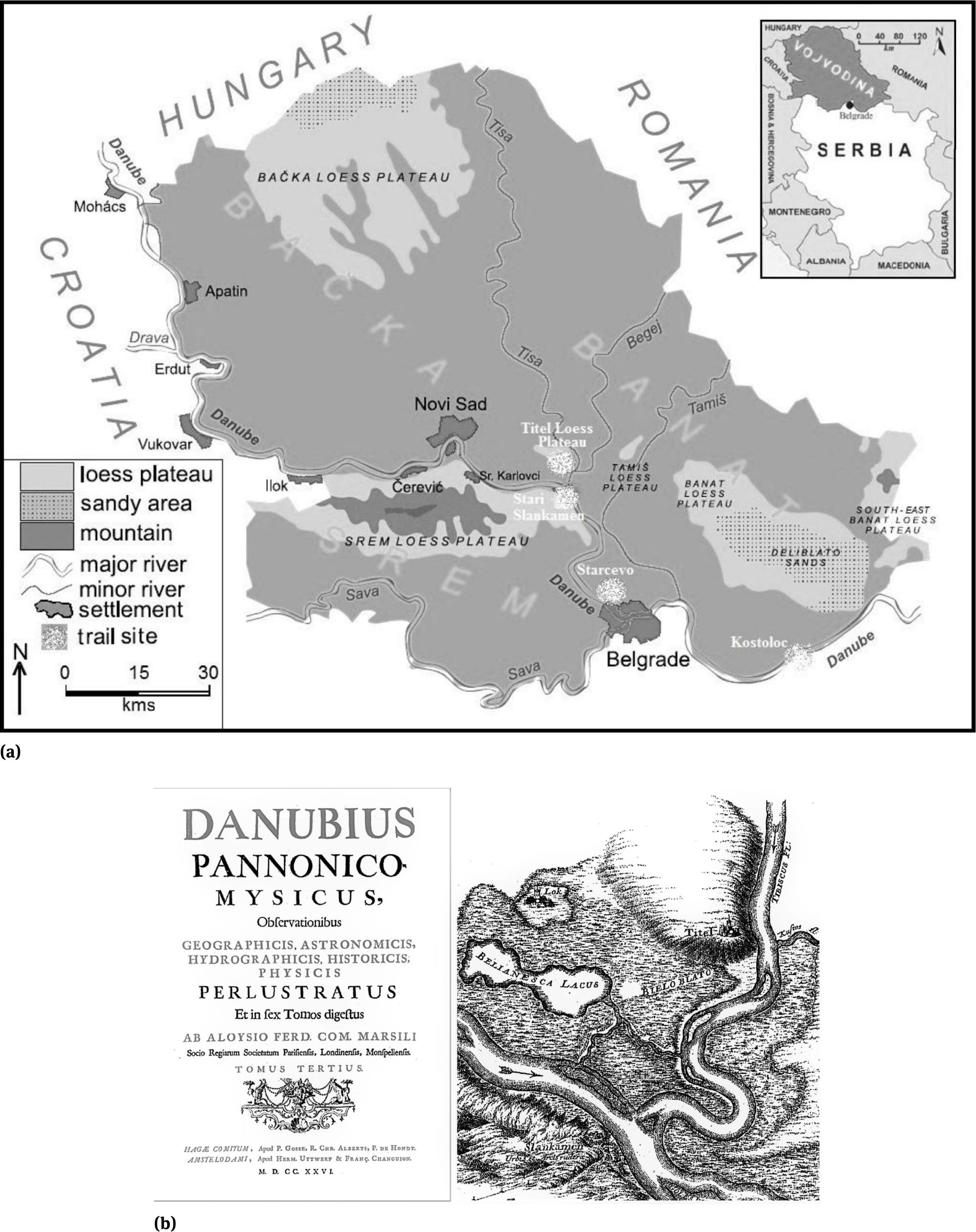
Loess and loess-like sediments cover almost two-thirds of the region [116] with six loess plateaus (Figure 10a). The sediments are much thicker and older than elsewhere in Europe, recording its last million years’ climate and natural environment [117]. High cliffs on the Danube’s southern bank expose repetitive loess and palaeosol sequences [116], the prominence of which led to their description of the Titel loess plateau [49] in the seventeenth century, in Danubius pannonico Mysicus [118] (Figure 10b), the first scientific description of European loess-palaeosol sequences; it has a rich diversity of minor loess landforms such as cliffs, gullies, caves, and pyramids [119] which can be appreciated from the cycle path between Novi Sad and Stari Slankamen. Because the loess-palaeosol sequences are readily visible in the cliffs, the most convenient way to admire them is either from a river cruise ship or the cycle path.
The Middle Danube Sites
a. Middle Danube Loess and Archaeological Sites Location Map – This shows the location on both banks of the river of the main geotrail sites and their relationship to the major loess features of the region. (based on Vasiljevic et al. 2016)
b. Title Page and Map from Danubius pannonico Mysicus – The volume’s title page (left) and map (right) showing the Titel loess plateau and Stari Slankamen from the first volume of Count Luigi Ferdinando Marsigli’s (1726) Danubius pannonico Mysicus
The Middle Danube Sites
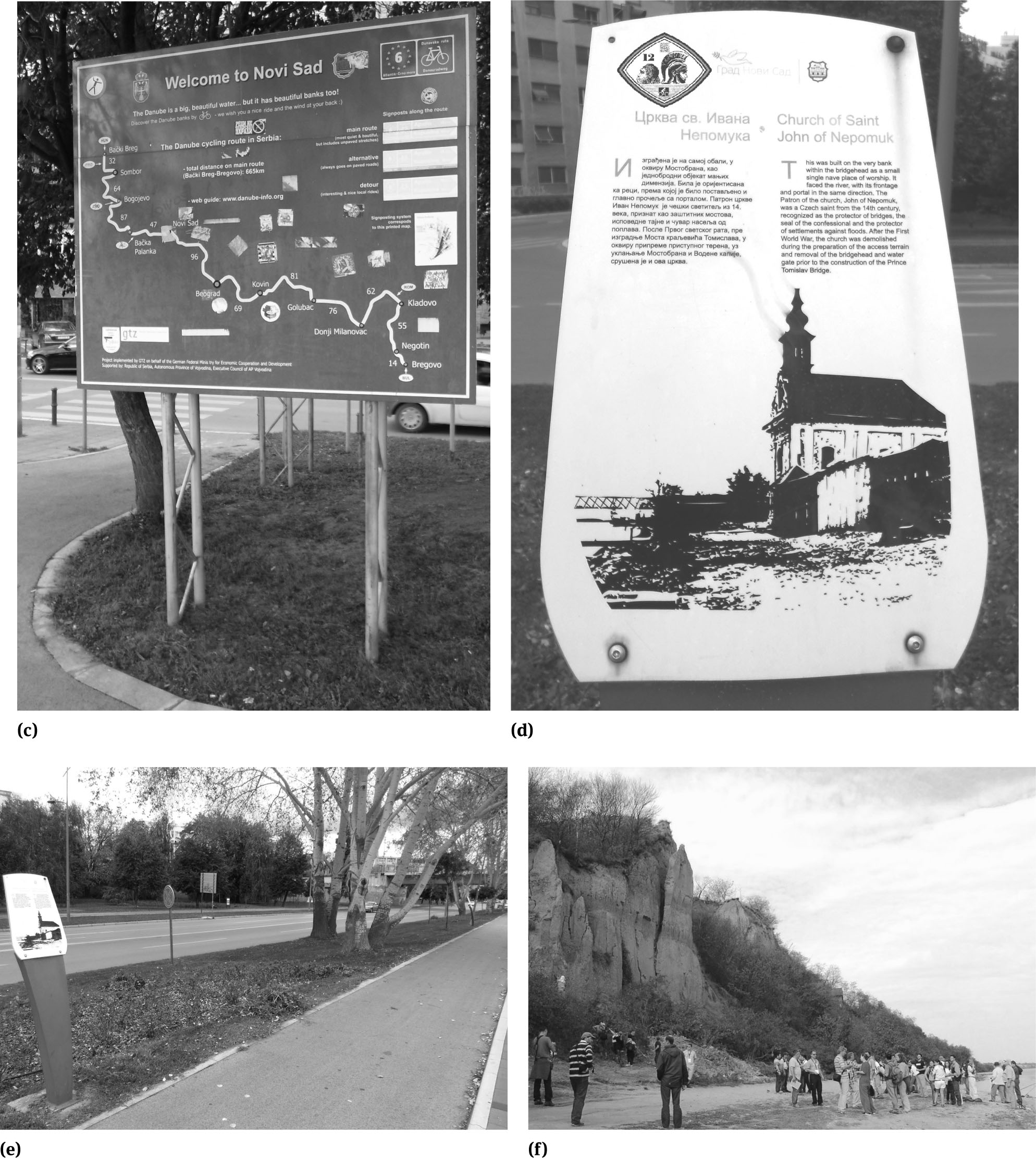
c. Novi Sad, EurVelo6 cycleway sign – Several of these large blue and white signs are positioned along the Danube side cycleway in the city
d. Novi Sad, cycleway sign – Alongside the cycleway are several small informational signs, such as this for the church of St. John of Nepomuk, about the city’s history
e. Novi Sad, St. John of Nepomuk cycleway sign – All the cycleway signs, like this one, have both Serbian and English texts; this one provides brief historical information about the church which was demolished sometime after 1918. The existing panel has been modified to illustrate how the tentative pan-European cycle route signage could be incorporated in the future
f. Stari Slankamen, cliffs on the Danube – These loess cliffs, first described by Count Luigi Ferdinando Marsigli in 1726, are some 40m high and two palaeosols, clearly marked by two dark bands, can be seen in the cliff
The Middle Danube Sites
g. Kostoloc, mammoth remains in the working pit – Photographed in situ in 2016 prior to their removal to the museum for conservation and exhibition. Two large curved tusks (in the middle of the frame) and several large leg bones from an incomplete skeleton rest on their plinths, formed when the rest of the surrounding material was excavated, on which they would later be lifted out for transport to the museum
h. Starčevo Visitor Centre – The initial proposal for a tourist park at this important Neolithic site included a glass and steel visitor centre, partly built into the site, with a grassed roof, somewhat in the form of a large Stone Age burial barrow
Various descriptions of Danube loess scenery, useful to provide some human-interest element in geointerpretation, were included in the accounts of several nineteenth century foreign tourists. Francis Davis Millet (1848-1912), an American artist, noted ‘…the river has washed away the hills into perpendicular bluffs, which are of earth almost as hard as sandstone…’ [120] and at ‘…O Szlankamen [Stari Slankamen], to the east a long range of flat hills now appeared, marking the course of the sluggish Theiss, and on the opposite bank we saw great rocks, scarcely distinguishable from the hard mud bluffs, but marking a distinct geological change in the landscape…’ [120]. Alfred William Parsons (1847-1920), an English illustrator and landscape painter, accompanied him on one cruise; he subsequently illustrated Millet’s book The Danube: From Black Forest to the Black Sea [120]. The same route is followed by a cycle path, described in a two-volume English language guide [121], EV6.
This is particularly well surfaced, signposted and interpreted in Serbia’s second city, Novi Sad (Figures 10c-10e). The EV6, which has made the three Danube sites accessible by cycle tourists, has been the main reason for the construction and promotion of cycle paths in Vojvodina province. A review [122] of Danube cycling, noted its signage, cycling maps and dedicated web-page were developed for the main EV6 route through Serbia. However, only a third of international Danube leisure cyclists considered the route well-surfaced, a quarter considering it very badly surfaced and 90% found the signage very bad, but many were from countries with long-established high-quality cycling infrastructure and [31]; so, any geoarchaeological route signage can only improve the situation! In Vojvodina the EV6 provides good access to several loess and archaeological sites on and adjacent to the Danube. Three of these are noteworthy for their significant Pleistocene and archaeological interest, coupled with geo-interpretative provision potential: Stari Slankamen; Kostolac, and Starcevo.
4.3.2 Stari Slankamen
Stari Slankamen is located on the northeastern part of the Srem Loess Plateau, one of six such, in Vojvodina province [123]. Its strategic location was recognized by the Romans in the first century BC with the founding of a settlement (Acumincum) and a fort in the first century AD. It is probably Europe’s supreme loess site, with the most complete palaeoclimatic change archive for the last 800,000 years. It particularly records the region’s Middle Pleistocene climate, providing an insight into local and regional atmospheric systems and their evolution [117]. Some 40m of loess, intercalated with nine major palaeo-pedocomplexes, is visible in the cliffs behind the village and nearby river banks (Figure 10f). They have attracted scientists and interested observers for almost 300 years but have only been extensively studied in the past 30 years. Their national and global significance was formally recognised in 1975 by designation, by the former state of Yugoslavia, as a Monument of Nature. In 2007 this was reinforced by designation as ‘The first category natural goods of Serbia’. Some of the sections have commemorative plaques denoting their significance. In the mid-2000s, a scheme was promoted to establish a major loess research centre and on-site museum “Loessland”, together with the establishment of a Vojvodina Loess Geopark [119]. The fully-glazed museum was to have been built against the highest loess cliff and include a multi-media exhibition to interpret its palaeoclimatic archive. It was to be a major geotourism attraction (with café, shop and tourist information centre) and a research centre to aid local economic regeneration. An overambitious scheme, even at a time of economic optimism, it has since been withdrawn. There is still potential for small-scale geo-interpretative provision (incorporating archaeological interest and cycling/walking routes) employing mobile phone technology and/or on-site panels affixed to buildings.
The village has several way-marked walking and cycling routes with viewpoints and access to loess sections, Roman archaeology, the salt spring “Slanaca” and to the Battle of Slankamen (of 19th August 1691, when an Austrian army fought off a Turkish army twice its size) Monument. The latter provides a vista of rolling hills with views of the Danube on one side and orchards and vineyards on the other. With only 10% inclines and partly over asphalt and gravel, the main path is suitable for leisure cyclists.
4.3.3 Kostoloc
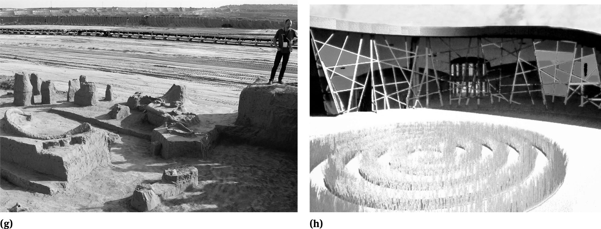
At Kostolac, the Drmno open-pit lignite coal-mine has revealed significant Pleistocene [124, 125] and Roman finds. From the 1st to the 6th centuries its Roman town, Viminacium, was an important Roman town and military encampment on the Roman Empire’s border defences, the Danube Limes. In and around the town an amphitheatre, monumental buildings, lavish thermae (baths) and the remains of a highly-developed urban infrastructure (particularly paved streets, freshwater aqueducts and sewage system) have been excavated. The exceptional quality of the finds made in the necropolis (with over 14,000 graves already found) confirms its citizens’ high status and wealth. The site is interpreted at a purpose-built, visitor-centre, somewhat in the style of a Roman palace.
In 2009 an almost complete in situ mammoth skeleton ([126], subsequently named Vika, and the scattered remains of mammoth skeletons were unearthed. Because they could not be preserved in situ they were removed in 2014 and are permanently exhibited (Figure 10g) and conserved in a palaeontological museum and park [127]. Also stored and exhibited there are mammoth remains, discovered in 2012, from Nosak [124]. The museum’s interior is decorated with sand and loess substrates with reconstructions of the Pleistocene flora to create an impression of the original environment. Additional museum displays show various dioramas, Ice Age animal reconstruction, and multimedia contents. Some space is set aside for children’s workshops, a wooden mammoth replica and a gift shop. The palaeontological museum and its park lie within the grounds of the Viminacium Archaeological Park.
4.3.4 Starčevo
At Starčevo, on the banks of the Danube, just north of Belgrade, two important Neolithic archaeological cultures, the Starčevo and Vinča, flourished. The Starčevo culture dates from 6,700 to 8,200 years ago. It represents the area’s earliest settled farming society, although hunter-gathering still provided much of their diet. The Vinča culture dates from around 6,500 to 7,700 years ago. It introduced farming technology to the region, enabling relatively large semi-permanent settlements. The inhabitant’s mixed diet came from agriculture, animal husbandry and huntergathering. Its farmers employed cattle-driven ploughs. Their innovations increased crop yields and enabled linen cloth weaving as well as leather and wool. The culture is noteworthy for the Vinča symbols, which might well be an undeciphered form of early writing. There have been proposals since 1912 for a tourist park and visitor-centre (Figure 10h) at Starčevo to display its locally excavated Neolithic wealth.
4.3.5 The EV6 as a Cyclists’ Geoarchaeological route
The current cycling infrastructure, centred around the EV6’s 96-km route between Novi Sad and Belgrade, makes access to the aforenoted sites relatively easy; it crosses the Danube, via a ferry, at Stari Slankamen. It also creates access to sites between these, such as the Titel loess plateau. Thus, the proposed geoarchaeological cyclists’ geotrail has sufficient Stone Age, Roman and loess and other geological sites to merits its development; this will be developed in draft form in 2018-2019 in co-operation with colleagues at the University of Novi Sad. The paucity of existing signage and interpretation along the route suggests that any geoarchaeological trail for cyclists is best presented as a web-based product, although QR code stickers, for uploading information to mobile devices, could be affixed to suitable structures.
5 Concluding Discussion
5.1 A Pan-European Approach
Despite research-led advice given almost 20 years ago that ‘Readily recognisable geotourism provision requires the acceptance of a pan-European interpretative ‘house style’ by the many and various national agencies and the establishment of a central co-ordinating body to oversee the preparation of: a) web-based virtual field guides and information sites; b) on-site panels; c) development of a programme of guided site visits in popular tourist areas; d) way-marked trails for walkers, cyclists and motorists…’ [1], even with the emergence of geoparks and the EGN, there is little evidence it has been heeded. European geointerpretative provision is still spatially and thematically fragmented. It is very much single site focused. Apart from the EGN branding of geoparks and that attempted by the ‘Ice Age Europe Network of Sites’, it generally lacks a coherent ‘house style’, a necessary pre-requisite to acquiring a recognisable brand identity with the public and casual geotourists such as leisure and touring cyclists. It does rather seem that unless some EU cross-border funding is accessed little or nothing seems to happen to develop international geo-interpretative schemes.
This might well be because of the perceived issues of cost and difficulty in establishing a workable management strategy, coupled with sourcing the relevant expertise in geology, archaeology and interpretation across several countries. One of the few bodies seemingly able to achieve such cross-border work has been ProGEO, as exemplified by its GEOSITES geoconservation project [128]. Possibly the European Geosciences Union (EGU), through a session at its annual General Assembly, could help to advertise and promote such a scheme as an aspect of public outreach, with one of its stated objectives being to ‘Increase public awareness of the scientific work of the EGU membership and facilitate dissemination of information beyond the geosciences community’ and with one of its target groups being ‘Decision makers, the working media and the non-scientific public, primarily but not exclusively in Europe’. However, such a project might best be developed with cycle route network partners, especially Sustrans in the UK and the European Cyclists’ Federation in mainland Europe. Such an approach would perhaps allow the new geoarchaeological trails to be highlighted on the standard NCN and EV route signage (Figure 11).

ECN route sign – This standard route sign is used across the UK to signpost cycle routes; it has been modified to illustrate how the geoarchaeological trail routing would be shown if it were adopted by the National Cycle Network
5.2 Geo-Interpretative Provision
In creating interpretative provision around Europe’s geoarchaeology, and the need for its conservation, through selected loess, river, Stone Age and Roman sites the nature of the media employed needs careful consideration. Although probably a past truism that ‘In examining trailside interpretative provision for tourists and like recreationalists it is informative to focus upon site panels, as these are the most suitable medium for unplanned casual usage. They can draw attention to a site and focus usage within it. They are available through-out the day and all year to users and, for them, they are free!’ [129] there are issues around such panels due to their initial cost, long-term maintenance and ability to cater for users with different language needs. On the latter point, there are many examples along the EV network of mono-linguistic signage or were a command of English is needed. It is perhaps archaic that such traditional, with lengthy reading times, flat-media approaches dominate geo-interpretative provision when the tourism industry is looking to reduce waste and encourage sustainability in its products [130] and the attention span of audiences has fallen; for example, reported research by the University of Western Ontario [131] found that the average human attention span has fallen from a mere 12 to just 8 seconds since 2000, around the time of mobile communications technologies’ growth. More widely in relation to traditional tourism media, AA Publishing announced in 2012 that it was no longer commissioning printed tourist guidebooks. The traditional media seemingly do not meet the information needs of the new younger, Millennials (18-34-year olds), audience of ‘Digital Travellers’ [132] that geotourism must attract, especially if it is to promote future geoconservation support. To maintain the sustainable and environmentally-friendly approach associated with cycling, the use of web-sites and smart-phone applications (with links to on-line guides and maps formatted for print-on-demand), the latter accessed by QR codes, could easily and inexpensively meet the challenge; they also have the advantage that they can, unlike dedicated site and route applications, be produced by relatively digitally illiterate authors more accustomed to preparing hard-copy publications - provided they understand the need to change writing style and publication format for on-screen viewing! Further, such geo-interpretative media are visually unobtrusive and relatively inexpensive to maintain and update. A cost-effective approach to providing the geointerpretative materials is that of generic informational materials on shared topics that are supplemented by site-specific materials. Generic informational themes could include common rocks, loess, fluvial geomorphology, and tectonics. The information on these should particularly stress the importance of these topics to humankind, where possible including archaeological examples. For example, an account of loess could explain its origins as an ice marginal deposit (just not in such terms!), map its distribution and show its use by the Romans for brick, tile and pottery production. Similarly, an account of diorite along the Rhine could explain its volcanic origins, map its distribution, and show its use for hand-axes.
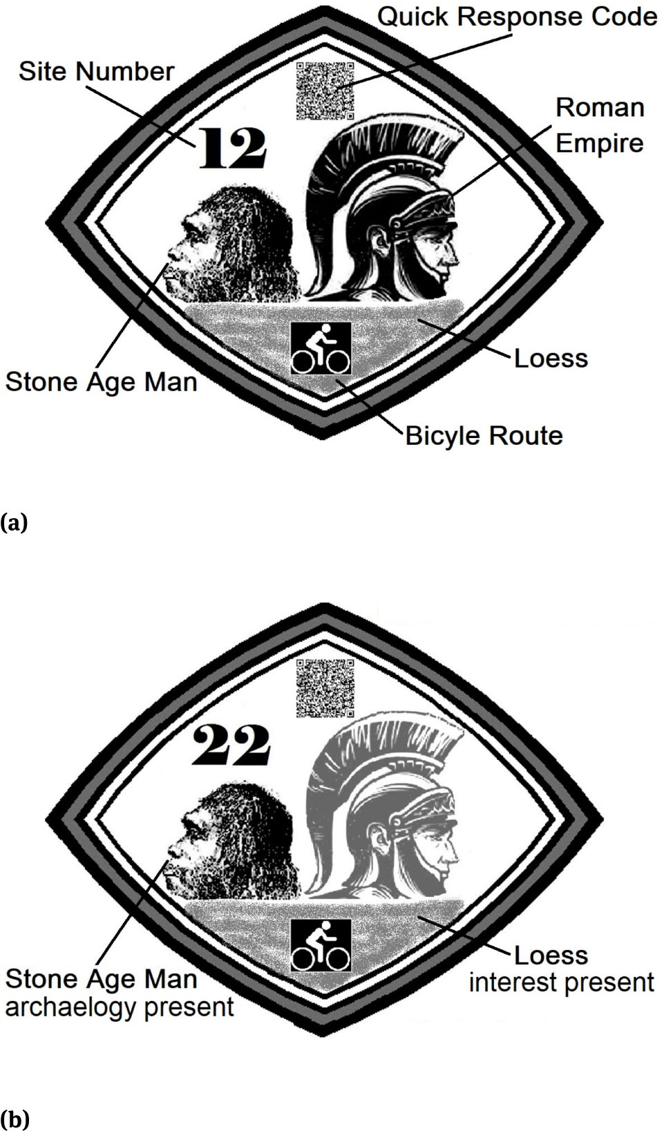
A monochrome lozenge design (Figures 12a-12b), printed on self-adhesive polyester paper and affixed to existing posts and panels with the QR codes linked to web-based resources, is an inexpensive means of promoting such an initial series of thematically linked geotrails. Later, if market research demonstrates their need, A2 and A3 temporary panels, also printed on self-adhesive polyester paper, could be affixed to the back of many existing metal directional signage. A readily identifiable corporate brand for geoarchaeological cyclists’ trails is necessary to link the work of various providers. Such a coherent and recognisable ‘house-style’ could readily be provided on electronic templates distributed via a dedicated website.
Loess Geotourism Trail Lozenge
A tentative design for a pan-European cycle route geotrail sign is for one that could easily be incorporated on existing signage (see Figure 10e). It need only be some 15 × 15 cm for the Quick Response Code symbol to be read by a smartphone. The various incorporated logos suggest the nature of what might be found at a specific site; those that could be found would be shown in black, whilst those not present would be shown in dark grey
This tentative design for a pan-European cycle route geotrail sign is shown as it would appear for use at a geosite with both Stone Age and loess, but no Roman, interests
5.3 Closing Thoughts
The cycle routes along Europe’s major and regional rivers demonstrably provide ideal access to their adjacent geoarchaeological sites and are ripe for development as cyclists’ geotrails as an added-value product to the normal route guides and signage. It was noted about geoconservation issues surrounding significant and scientifically well-known sites on the Lower River Thames [133] that gravel and sand extraction had almost ceased ‘… and opportunities for examining sections in the…terrace deposits are essentially restricted now to temporary sections, made available during development, and conservation sites… Careful management of these sites… should be given a high priority. In recent years, almost every one… suffered degradation and piecemeal erosion by industrial or residential development…development pressures on a fragile and already greatly diminished geological resource are such that its future protection cannot be viewed with any great degree of confidence…’ [133]. Those remarks could apply to just about any of the riverside geoarchaeological sites noted in the case studies. It is not enough that such sites are well-known and lauded by geologists and archaeologists. Without the knowledge and support of all stakeholders, their overall societal value will not be recognized, and they will eventually be lost to future generations. Geoarchaeological geotourism has the potential to raise general, let alone leisure and touring cyclists’, awareness of such sites and to constituency-build amongst them for their future preservation and ensured continued access.
Acknowledgement
The invaluable research facilities, without which the desktop study would have been much incomplete, afforded me by the by the School of Earth Sciences, University of Bristol are most gratefully recognised. The invitation and hospitality extended by colleagues, especially Krzysztof Widawski, from the University of Wroclaw for the 2nd Geotrends conference is thankfully acknowledged. Finally, some of the case study sites could not have been examined in the field without the support of various colleagues, most particularly Djordjije Vasiljevic at the University of Novi Sad, and the forbearance of my wife, Sharon, on a Middle Rhine cycling holiday. I thank the two anonymous reviewers of the initial draft of this paper for their variously frank and supportive comments.
References
[1] Hose, T.A., European Geotourism – Geological Interpretation and Geoconservation Promotion for Tourists. In: Barretino, D., Wimbledon, W.A.P, Gallego, E. (Eds.) Geological Heritage: Its Conservation and Management. Sociedad Geologica de Espana/Instituto Technologico GeoMinero de Espana/ ProGEO, Madrid, 2000, 127-146Search in Google Scholar
[2] Wimbledon, W.A.P., Smith-Meyer, S. (Eds.) Geoheritage in Europe and its Conservation, ProGEO, Oslo, 2012Search in Google Scholar
[3] Pucher, J., Buehler, R. Cycling towards a more sustainable transport future, Transp Rev, 2017, 37:6, 689-69410.1080/01441647.2017.1340234Search in Google Scholar
[4] Hose T.A., Geotourism - appreciating the deep time of landscapes. In: Novelli, M. (Ed.) Niche Tourism: Contemporary Issues, Trends and Cases. Elsevier, Oxford, 2005, 27-37Search in Google Scholar
[5] Novelli, M. (Ed.), Niche Tourism: Contemporary Issues, Trends and Cases. Elsevier, Oxford, 2005Search in Google Scholar
[6] Beanland, A. 2013. Cycle Tourism for Sustainable Rural Development: Understanding and Interpreting Lessons from Europe - A report of a Winston Churchill Travelling Fellowship. The Winston Churchill Memorial Trust, London, 2013Search in Google Scholar
[7] Nagel, T. CBI Product Factsheet: Cycling Tourism from Europe. CBI Ministry of Foreign Affairs, The Hague, 2015Search in Google Scholar
[8] Hose, T.A. (Ed.), Appreciating Physical Landscapes: Three Hundred Years of Geotourism, Special Publication 417. The Geological Society, London, 2016, 410.1144/SP417.0Search in Google Scholar
[9] Hose, T.A., 3G’s for Modern Geotourism. Geoheritage, 2012, 4 (1-2), 7-2410.1007/s12371-011-0052-ySearch in Google Scholar
[10] Hose, T.A. (Ed.), Geoheritage and Geotourism: A European Perspective. The Boydell Press, Woodbridge, 2016, 26-27, 310Search in Google Scholar
[11] Gray, M., Geodiversity –Valuing and Conserving Abiotic Nature. New York, John Wiley and Sons, New York, 2004Search in Google Scholar
[12] Hose T.A., Geotourism – selling the Earth to Europe. In: Marinos, P.G., Koukis, G.C., Tsiamaos, G.C., Stournass, G.C. (Eds.) Engineering Geology and the Environment. Rotterdam, A.A. Balkema, Rotterdam, 1997, 2955-60Search in Google Scholar
[13] Heywood, P., Truth and beauty in landscape – trends in landscape and leisure. Landscape Australia, 1990, 12 (1), 46Search in Google Scholar
[14] Plogg, S.C., Why Destination Areas Rise and Fall in Popularity. The Cornell Hotel and Restaurant Administration Quarterly, 1974, 15, 55-5810.1177/001088047401400409Search in Google Scholar
[15] Hall, C.M., Weiler, B., What’s special about special interest tourism? In: Weiler, B., Hall, C.M. (Eds.) Special Interest Tourism. Belhaven, London, 1992, 4Search in Google Scholar
[16] Hose T.A, Selling the story of Britain’s stone. Environmental Interpretation, 1995, 10 (2), 16-17Search in Google Scholar
[17] Hose, T.A., Geotourism or can tourists become casual rock hounds? In: Bennett, M.R., Doyle, P., Larwood, J.G., Prosser, C.D. (Eds.) Geology on Your Doorstep: The role of urban geology in earth heritage conservation. The Geological Society, London, 1996, 207-228Search in Google Scholar
[18] Hose, T.A., Selling coastal geology to visitors. In: Hooke, J. (Ed.) Coastal Defence and Earth Science Conservation. The Geological Society, London, 1998, 178-195Search in Google Scholar
[19] Ennos, R., Beefing up botany. Biologist, 1998, 45 (4), 192Search in Google Scholar
[20] Hose, T.A., 3G’s for Modern Geotourism. Geoheritage, 2012, 4 (1-2), 1710.1007/s12371-011-0052-ySearch in Google Scholar
[21] Barrow, G., Environmental Interpretation and Conservation in Britain. In: Goldsmith, F.B., Warren, A. (Eds.) Conservation in Progress. John Wiley and Sons, Chichester, 1993, 271Search in Google Scholar
[22] Hewison, R., The Heritage Industry: Britain in a Climate of Decline. Methuen, London, 1987Search in Google Scholar
[23] Light, D., Visitors’ use of interpretive media at heritage sites. Leis Stud, 1995, 14, 132-14910.1080/02614369500390111Search in Google Scholar
[24] Phillips, A., Interpreting the Countryside and the Natural Environment. In: Uzzell, D.L. (Ed.) Heritage Interpretation Volume 1 – The Natural and Built Environment. Belhaven Press, London, 1989, 127Search in Google Scholar
[25] Gonggrijp, G.P., Nature development: Biologist’s experimental garden! Geologist’s future sand box? In: Marinos, P.G., Koukis, G.C., Tsiambaos, G.C. Stournas, G.C. (Eds.) Engineering Geology and the Environment. A.A. Balkema, Rotterdam, 1997, 2946-2947Search in Google Scholar
[26] Jones, D.M. (Ed.). Geoarchaeology: Using earth sciences to understand the archaeological record. English Heritage, Swindon, 2004Search in Google Scholar
[27] Canti, M., Corcoran, J. (Eds.), Geoarchaeology: Using earth sciences to understand the archaeological record. Historic England, London, 2015Search in Google Scholar
[28] French, C.A. I., Geoarchaeology in Action: Studies in Soil Micromorphology and Landscape Evolution. Routledge, London, 2003Search in Google Scholar
[29] Holliday, V. T., Soils in Archaeological Research. Oxford University Press, New York, 200410.1093/oso/9780195149654.001.0001Search in Google Scholar
[30] Pettitt, P., Gamble, C., Last, J., Research and Conservation Framework for the British Palaeolithic. English Heritage, London, 2008Search in Google Scholar
[31] Vujko, A., Gajic, T., Opportunities for tourism development and cooperation in the region by improving the quality of tourism services – the ‘Danube Cycle Route’ case study, Economic Research-Ekonomska Istraživanja, 2014, 27 (1), 847-86010.1080/1331677X.2014.975517Search in Google Scholar
[32] Datzer, R., Fahrradtourismus-wirtschaftliche Bedeutung und perspektiven für die Tourismusentwicklung in Nordrhein-Westfalen. Proceedings: Workshop Qualitätsoffensive für den Fahrradtourismus in Nordrhein-Westfalen. ADFC, Marl, 16 May, 1998, 9-11Search in Google Scholar
[33] Ritchie, B.W., Bicycle tourism in the South Island of New Zealand: Planning and Management Issues. Tourism Manage, 1988, 19 (6), 567-58210.1016/S0261-5177(98)00063-6Search in Google Scholar
[34] Keeling, A., Cycle Tourism: Information Pack TT21. Sustrans, Bristol, 1999Search in Google Scholar
[35] Harrison, L.C., Husbands, W., Practicing Responsible Tourism: International Case Studies in Tourism Planning, Policy, and Development. New York, John Wiley and Sons, New York, 1996Search in Google Scholar
[36] Lumsden, L., Transport and Tourism: Cycle Tourism – A Model for Sustainable Development? J Sustain Tour, 2000, 8 (5), 2361-37710.1080/09669580008667373Search in Google Scholar
[37] Swarbrooke, J., Sustainable Tourism Management. CABI Publishing, Wallingford, 199910.1079/9780851993140.0336Search in Google Scholar
[38] Piket, P., Eijgelaar, E., Peeters, P., European cycle tourism: tool for sustainable regional rural development? Paper presented at the Second AGRIMBA-AVA Congress, Wageningen, 2011 [http://ageconsearch.umn.edu/bitstream/164816/2/19_Piket.pdf]Search in Google Scholar
[39] Hose, T.A., Awheel in Edwardian Bedfordshire: a 1905 Geologists’ Association cycling excursion revisited and contextualised. Proc Geol Assoc, 2018, (in press)10.1016/j.pgeola.2018.07.004Search in Google Scholar
[40] Cole, G. A. J., The Gypsy Road: a Journey from Krakow to Coblenz. Macmillan and Co., London and New York, 1894Search in Google Scholar
[41] Cole, G. A. J., Cole, B., As We Ride. Dublin, Royal City of Dublin Hospital, Dublin, 1902Search in Google Scholar
[42] Wyse Jackson, P.N. 2007. Grenville Arthur James Cole (1859–1924): the cycling geologist. In: Wyse Jackson, P.N. (Ed.) Four Centuries of Geological Travel: The Search for Knowledge on Foot, Bicycle, Sledge and Camel, Special Publication 287. The Geological Society, London, 2007, 135-147Search in Google Scholar
[43] Cole, G. A. J., Open-Air-Studies: an Introduction to Geology Out-of-Doors. London, Griffin and Co., London, 1895Search in Google Scholar
[44] Cole, G. A. J., The Growth of Europe. Williams and Norgate, London, 1914Search in Google Scholar
[45] Hose, T.A., Awheel from Flitwick Station: an ‘Edwardian’ Geotrail. Rockhounds Welcome! Chalton, 2017Search in Google Scholar
[46] Carpenter, S., Public geology: promoting the Pennant Sandstone in Bristol. Geology Today, 1997, 13 (6), 212–21310.1046/j.1365-2451.1997.d01-602.xSearch in Google Scholar
[47] Hose, T.A. (Ed.), Geoheritage and Geotourism: A European Perspective. The Boydell Press, Woodbridge, 2016Search in Google Scholar
[48] Hose T.A., Geotourism in England: a two-region case study analysis. PhD thesis Birmingham, University of Birmingham, United Kingdom, 2003Search in Google Scholar
[49] Vasiljević, Dj.A., Marković, S.B., Hose, T.A., Smalley, I., Basarin, B., Lazić, L., et al., The Introduction to Geoconservation of Loess-Palaeosol Sequences in the Vojvodina Region: significant Geoheritage of Serbia. Quatern Int, 2011a, 240 (1-2), 108-11610.1016/j.quaint.2010.07.008Search in Google Scholar
[50] Vasiljević, Dj. A., Marković, S.B., Hose, T.A., Ding, Z., Guo, Z., Liu, X., et al., Loess-palaeosol sequences in China and Europe: Common values and geoconservation issues. Catena, 2014, 117, 108-11810.1016/j.catena.2013.06.005Search in Google Scholar
[51] Vasiljević, Dj. A., Marković, S.B., Vujicic, M.D., Appreciating loess landscapes through history: the basis of modern loess geotourism in the Vojvodina region of North Serbia. In: Hose, T.A. (Ed.) Appreciating Physical Landscapes: Three Hundred Years of Geotourism, Special Publication 417. The Geological Society, London, 2016, 229-239Search in Google Scholar
[52] Jovanovic´, M., Gaudenyi, T., O’Hara-Dhand, K., Smalley, I., Karl Caesar von Leonhard (1779-1862), and the beginnings of loess research in the Rhine valley. Quatern Int, 2014, 334-335, 4-910.1016/j.quaint.2013.02.003Search in Google Scholar
[53] Kukla, G.J., Pleistocene land-sea correlations. Earth Science Reviews, 1977, 13, 307-37410.1016/0012-8252(77)90125-8Search in Google Scholar
[54] Smalley, I.J., Jeferson, I.F., Dijkstra, T.A., Derbyshire, E., Some major events in the development of the scientific study of loess. Earth Science Reviews, 2001, 54, 5-1810.1016/S0012-8252(01)00038-1Search in Google Scholar
[55] Head, M.J., Gibbard P.L., Salvador, A., The Quaternary: its character and definition. Episodes, 2008, 31, 234-23810.18814/epiiugs/2008/v31i2/009Search in Google Scholar
[56] Gibbard, P. L., Head, M. J., Walker, M. J. C. and the Subcommission on Quaternary Stratigraphy. Formal ratification of the Quaternary System/Period and the Pleistocene Series/Epoch with a base at 2.58 Ma. J. Quaternary Sci, 2010, 25, 96–10210.1002/jqs.1338Search in Google Scholar
[57] Gavrilov, M.B., Marković, S.B. Schaetzl, R.J., Tošić, I. Zeeden, C., Obreht, I., et al., Prevailing surface winds in Northern Serbia in the recent and past time periods; modern- and past dust deposition, Aeolian Research, 2017 (Article in press)10.1016/j.aeolia.2017.07.008Search in Google Scholar
[58] Lill, G. O., Smalley, I.J., Distribution of loess in Britain. Proc Geol Assoc, 1978, 89 (1), 57-6510.1016/S0016-7878(78)80021-2Search in Google Scholar
[59] Derbyshire, E., Geological hazards in loess terrain, with particular reference to the loess regions of China. Earth-Science Reviews 2001, 54, 231-26010.1016/S0012-8252(01)00050-2Search in Google Scholar
[60] Lukic´, T., Markovic´, S. B., Stevens, T., Vasiljević, D.A., Machalett, B., Milojkovići, N., et al., The loess ‘cave’ near the village of Surduk – an unusual pseudokarst landform in the loess of Vojvodina, Serbia. Acta Carsologica, 2009, 38 (2), 227-23510.3986/ac.v38i2-3.124Search in Google Scholar
[61] Bakels, C.C., The Western European Loess Belt: Agrarian History, 5300BC-AD1000. Springer, Heidelberg, 200910.1007/978-1-4020-9840-6Search in Google Scholar
[62] Bridgland, D. R., Antoine, P., Limondin-Lozouet, N., Santiseban, J., Westaway, R., White, M.J., The Palaeolithic occupation of Europe as revealed by evidence from the rivers: data from IGCP 449. J Quaternary Sci, 2006, 21 (5), 437-45510.1002/jqs.1042Search in Google Scholar
[63] Roebroeks W, Kolfschoten, T. van (Eds.). The Earliest Occupation of Europe. University of Leiden Press, Leiden, 1995Search in Google Scholar
[64] Wymer, J.J., Lower Palaeolithic Archaeology in Britain as represented by the Thames Valley. John Baker, London, 1968, 429Search in Google Scholar
[65] Wymer, J.J., Palaeolithic archaeology and the British Quaternary sequence. Quaternary Sci Rev, 1988, 7, 79–9810.1016/0277-3791(88)90095-9Search in Google Scholar
[66] Wymer, J.J. The Lower Palaeolithic Occupation of Britain (2 vols).Wessex Archaeology and English Heritage, Salisbury,1999, 234Search in Google Scholar
[67] ‘Ice Age Europe Network of Heritage Sites’ (https://www.ice-age-europe.eu/)Search in Google Scholar
[68] Perrin, R.M.S., Davies, H., Fysh, M.D., Distribution of late Pleistocene aeolian deposits in eastern and southern England. Nature, 1974, 248, 320-32410.1038/248320a0Search in Google Scholar
[69] Oake, M., Luke, M., Dawson, M., Edgeworth, M., Murphy, P., Bedfordshire Archaeology: Research and Archaeology: Resource Assessment, Research Agenda and Strategy - Bedfordshire Archaeology Monograph 9. Bedford, Bedfordshire County Council / The Bedfordshire Archaeological Council, Bedford, 2007, 8Search in Google Scholar
[70] Austin, L., Palaeolithic and Mesolithic. In: Brown, N., Glaze-brook, J. (Eds.) Research and Archaeology: A Framework for the Eastern Counties 2. Research Agenda and Strategy – East Anglian Archaeology Occasional Paper 8. East Anglian Archaeology, Norwich, 2000, 7Search in Google Scholar
[71] Wymer, J.J., The Excavation of the Acheulian site at Gaddesden Row. Bedfordshire Archaeological Journal, 1980, 14, 2-4Search in Google Scholar
[72] Wyatt, J., Flint implements in the drift. Bedfordshire Architectural and Archaeological Society Transactions, 1861, 1-17Search in Google Scholar
[73] Wyatt, J., On some further discoveries of flint implements in the gravel near Bedford. Quarterly Proceedings of the Geological Society of London, 1862, 18, 113-510.1144/GSL.JGS.1862.018.01-02.22Search in Google Scholar
[74] Harding, P. Bridgland, D., Keen, D., Rogerson, R., A Palaeolithic Site Rediscovered at Biddenham, Bedfordshire. Bedfordshire Archaeology, 1991, 19, 87-90Search in Google Scholar
[75] Loveday, J., Plateau Deposits of the Southern Chiltern Hills. Proc Geol Assoc, 1962, 7 (1), 83-10210.1016/S0016-7878(62)80019-4Search in Google Scholar
[76] Avery, B.W., Bullock, P., Catt, J.A., Rayner, J.H., Weir, A.H., Composition and origin of some brickearths on the Chiltern Hills, England. Catena, 1982, 9 (1-2), 153-17410.1016/S0341-8162(82)80011-8Search in Google Scholar
[77] Hertfordshire County Council, Ver Valley Walk 1: The Source Walk. Hertfordshire County Council Countryside Management Serviće, Hertford, 2011Search in Google Scholar
[78] Smith, W.G., Notes on the Paleolithic Floor near Caddington. Archaeologia, 1916, 67, 49-7410.1017/S026134090000775XSearch in Google Scholar
[79] Smith, R. A., On flint implements from the Palaeolithic ‘floor’ at Whipsnade, Beds. Proceedings of the Society of Antiquaries, 1919, Series 2, 31, 39-50Search in Google Scholar
[80] Smith, W. G., Dunstable: Its History and Surroundings. London and Dunstable, The Homeland Association for the Encouragement of Touring in Great Britain, in co-operation with the Corporation of Dunstable, Dunstable, 1904, 22-33Search in Google Scholar
[81] Smith, W. G., Man the Primeval Savage: his haunts and relics from the hilltops of Bedfordshire to Blackwall. Stanford, London, 1894Search in Google Scholar
[82] Campbell, J. B., Sampson, C. G., The Cottages Site. In: Sampson, C.G. (Ed.) Paleoecology and archaeology of an Acheulian site at Caddington, England. Southern Methodist University, Dallas, 1978, 61-83Search in Google Scholar
[83] White, M.J., The Earlier Palaeolithic occupation of the Chilterns: reassessing the sites of Worthington G. Smith. Antiquity, 1997, 71, 912-93110.1017/S0003598X00085823Search in Google Scholar
[84] Bridgland, D. R., Harding, P., Investigations at Gaddesden Row Brickpit, Hertfordshire. Quaternary Newsletter, 1989, 59, 2-4Search in Google Scholar
[85] Catt, J.A and Hagan, R.E., Geological background. In: Sampson, C.G. (Ed.) Paleoecology and archaeology of an Acheulian site at Caddington, England. Southern Methodist University, Dallas, 1978, 17-28Search in Google Scholar
[86] White, M.J, Lewis, S.G., McNabb, J., Excavations at the Lower Palaeolithic site of Whipsnade, Bedfordshire 1992-4. Proc Geol Assoc, 1999, 110 (3), 241-25510.1016/S0016-7878(99)80074-1Search in Google Scholar
[87] Dony, J.G., Geological Factors. In: Dony, J.G., Flora of Bedforshire. Luton Museum and Art Gallery, Luton, 1953, 43-45Search in Google Scholar
[88] Nau, B.S., Bedfordshire from Geological Times. In: Nau, B.S. Boon, C.R., Knowles, J.P. Bedfordshire Wildlife. Ware, Castlemead Publications, Ware, 1987, 1-12Search in Google Scholar
[89] Nicholls, G.D., Introduction to the Geology of Bedfordshire. Journal of the Bedfordshire Natural History Society and Field Club, 1947, 2, 9-16Search in Google Scholar
[90] Whiteley, M.J., Farewell, T.S., Chapter 2: Geology, soils and plant communities in Bedfordshire. In: Boon, C.C. (with Outen, A.R.) (Ed.) Flora of Bedfordshire. Bedfordshire Natural History Society, Bedford, 2011, 11-21Search in Google Scholar
[91] Barron, A.J.M., Sumbler, M.G., Morigi, A.N., Reeves, H.J., Benham, A.J., Entwisle, D.C., Gale, I.N., Geology of the Bedford district: a brief explanation of the geological map Sheet 203 Bedford. British Geological Survey, Keyworth, 2010Search in Google Scholar
[92] Shephard-Thorn, E.R., Moorlock, B.S.P., Cox, B.M., Allsop, J.M., Wood, C.J., Geology of the country around Leighton Buzzard. Memoir of the British Geological Survey sheet 220 (England and Wales). HMSO, London, 199410.1016/0148-9062(94)90020-5Search in Google Scholar
[93] Cameron, A.C.G., Excursion to Ampthill and Bedford, July 25th 1885. Proc Geol Assoc, 1885, 9 (4), 225-22710.1016/S0016-7878(85)80041-9Search in Google Scholar
[94] Cameron, A.C.G., Excursion to Bedford and Clapham, July 21st1888. Proc Geol Assoc, 1888, 10 (9), 504-51010.1016/S0016-7878(88)80017-8Search in Google Scholar
[95] Woodward, H.B., Excursion to Bedford. Saturday, May 27th, 1905. Proc Geol Assoc, 1905, 19 (3), 142-14610.1016/S0016-7878(05)80034-3Search in Google Scholar
[96] Hopkinson, J., Excursion to Flitwick and Silsoe. Proc Geol Assoc, 1905, 65 (1), 110-11310.1016/S0016-7878(05)80029-XSearch in Google Scholar
[97] Fadden, K., Mesolithic Flints from Bead low Manor Farm, Clophill. Bedfordshire Archaeological Journal, 1973, 8, 131Search in Google Scholar
[98] Hopkinson, J., Excursion to Flitwick and Silsoe. Proc Geol Assoc, 1905, 65 (1), 11110.1016/S0016-7878(05)80029-XSearch in Google Scholar
[99] Hopkinson, J., Excursion to Flitwick and Silsoe. Proc Geol Assoc, 1905, 65 (1), 110-11310.1016/S0016-7878(05)80029-XSearch in Google Scholar
[100] Prestwich, J., Notes on some further discoveries of flint implements in beds of post-Pliocene gravel and clay; with a few suggestions for search elsewhere, Quarterly Journal of the Geological Society of London, 1861, 17, 36610.1144/GSL.JGS.1861.017.01-02.36Search in Google Scholar
[101] Prestwich, J., Notes on some further discoveries of flint implements in beds of post-Pliocene gravel and clay; with a few suggestions for search elsewhere, Quarterly Journal of the Geological Society of London, 1861, 17, 362-36810.1144/GSL.JGS.1861.017.01-02.30Search in Google Scholar
[102] Prestwich, J., Theoretical considerations of the conditions under which the (Drift) deposits containing the remains of extinct Mammalia and flint implements were accumulated and on their geological age. Philosophical Transactions of the Royal Society of London, 1862, 154, 247-30910.1098/rstl.1864.0007Search in Google Scholar
[103] Evans, J., The ancient stone implements, weapons and’ ornaments of Great Britain. London, Longmans, London, 1872Search in Google Scholar
[104] Wyatt, J., Flint implements in the drift. Bedfordshire Architectural and Archaeological Society Transactions, 1861, 1-17Search in Google Scholar
[105] O’Connor, A., Finding Time for the Old Stone Age: A History of Palaeolithic Archaeology and Quaternary Geology in Britain, 1860-1960. Oxford University Press, Oxford, 2007, 7810.1093/oso/9780199215478.001.0001Search in Google Scholar
[106] Luke, M., Palaeolithic, Mesolithic, early Neolithic and late Neolithic/early Bronze Age In M. Oake, M. Luke, M. Dawson, M. Edgeworth and P. Murphy (Eds.), Bedfordshire Archaeology: Research and Archaeology; Resource assessment, research agenda and strategy. Bedfordshire Archaeology Monograph 6, 2007, 21, 24Search in Google Scholar
[107] Woodward, H.B., Excursion to Bedford. Saturday, May 27th, 1905. Proc Geol Assoc, 1905, 19 (3), 142-14610.1016/S0016-7878(05)80034-3Search in Google Scholar
[108] Kennard, A.S., Woodward, B.B., The Post-Pliocene non-marine Mollusca of the East of England. Proc Geol Assoc, 1922, 33 (2), 119-12010.1016/S0016-7878(22)80002-XSearch in Google Scholar
[109] Luke, M., Life in the Loop: investigation of a prehistoric and RomanoBritish landscape at Biddenham Loop, Bedfordshire. East Anglian Archaeology, 2008, 125, 73Search in Google Scholar
[110] Hose, T.A., Rocks, Rudists & Writing: An Examination of Populist Geosite Literature. In: Addison, K. (Ed.) Proceedings of the Third UK Annual Rigs Conference, Newton Rigg, Penrith, 2000, 39-62Search in Google Scholar
[111] Hose, T.A., Leading the Field: A Contextual Analysis of the Field-Excursion and the Field-Guide in England. In: Wickens, E., Hose, T.A., Humberstone, B. (Eds.) Critical Issues in Leisure and Tourism Education, High Wycombe, Leisure and Tourism Education Research Centre, Buckinghamshire Chilterns University College, 2006, 15-132Search in Google Scholar
[112] Wells, M., The Rhine Cycle Route, from Source to Sea (2nd edn.). Cicerone, Milnthorpe, 2015Search in Google Scholar
[113] Turner E., Large vertebrates from the Middle Palaeolithic levels at Wallertheim, Rheinhessen. In Conard, N.J. and Kandel A.W. (Eds.) Reports for the Second Wallertheim Workshop. Tubingen, Institut fur Ur und Frugeschichte, 1997, 87-93Search in Google Scholar
[114] Bosinski, G., 15 Palaeolithic sites in the Rheinland. In: Schirmer, W. (Ed.), Quaternary field trips in Central Europe, vol. 2, INQUA, Munich, 1995, 829-999Search in Google Scholar
[115] Turner, E., Ariendorf: Quaternary Deposits and Palaeolithic Excavations in the Karl Schneider Gravel Pit. With contributions by W. Boenigk, M. Frechen, M. van Kolfschoten, E. Schnepp, E. Sefkov & K. Steensma. Jahrbuch des Römisch-Germanischen Zentralmuseums, Mainz, 1997, 44 (1), 3-191Search in Google Scholar
[116] Marković, S.B., Smalley, I., Hambach, U., Antoine, P., Loess in the Danube region and surrounding loess provinces: The Marsigli memorial volume. Quatern Int, 2009, 198, 5-610.1016/j.quaint.2009.02.001Search in Google Scholar
[117] Marković, S.B., Hambach, U., Stevens, T., Kukla, G.J., Heller, F., McCoy, W.D., et.al., The last million years recorded at the Stari Slankamen (Northern Serbia) loess–palaeosol sequence: revised chronostratigraphy and longterm environmental trends. Quaternary Sci Rev, 2011, 30, 1142-115410.1016/j.quascirev.2011.02.004Search in Google Scholar
[118] Marsigli, L.F., Danubius Pannonico Mysicus. Observationibis Geographicis, Astronomicis, Hydrographicis, Physicis; perlustratus. Grosse, P., Alberts, Chr., de Hoodt, P., Herm. Uytwert and Franc Changuion, The Hague and Amsterdam, 1726Search in Google Scholar
[119] Vasiljevic´, Dj. A., Markovic´, S. B. et al.. Loess towards (geo) tourism – proposed application on loess in Vojvodina region (north Serbia). Acta Geographica Slovenica, 2011, 51 (3), 391-40610.3986/AGS51305Search in Google Scholar
[120] Millet, F. D., The Danube: From Black Forest to the Black Sea. Harper and Brothers, New York, 1893Search in Google Scholar
[121] Wells, M., The Danube Cycleway (in two vols.). Cicerone, Milnthorpe, 2015 and 2016Search in Google Scholar
[122] Vujko, A., Plavsa, J., Ostojic, N., Impact of the “Danube Cycling Route” on the Development of Cycling Tourism in Serbia. Policy Journal of Sport Tourism, 2013, 20, 227-2310.2478/pjst-2013-0021Search in Google Scholar
[123] Marković, S.B., Hambach, U., Stevens, T., Jovanović, M., O’Hara-Dhand, K., Basarin, B., et.al., Loess in the Vojvodina region (Northern Serbia): an essential link between European and Asian Pleistocene environments. Neth J of Geosci, 2012, 91, 173-18810.1017/S0016774600001578Search in Google Scholar
[124] Marković, S.B., Korać, M., Mrđić, N., Buylaert, J.P., Thiel, C., McLaren, S.J., et.al., Palaeoenvironment and geoconservation of mammoths from the Nosak loess– palaeosol sequence (Drmno, northeastern Serbia): initial results and perspectives. Quatern Int, 2014, 334–335, 30-3910.1016/j.quaint.2013.05.047Search in Google Scholar
[125] Dimitrijević, V., Mrdjić, N., Korać, M., Chu, S., Kostić, D., Jovičić, M. and Blackwell, B.A., The latest steppe mammoths (Mammuthus trogontherii (Pohlig)) and associated fauna on the Late Middle Pleistocene steppe at Nosak, Kostolac Basin, Northeastern Serbia. Quartern Int, 2015, 379, 14-2710.1016/j.quaint.2015.06.025Search in Google Scholar
[126] Lister, A.M., Dimitrijević, V., Marković, Z., Knežević, S. and Mol, D., A skeleton of ‘steppe’ mammoth (Mammuthus trogontherii (Pohlig)) from Drmno, near Kostolac, Serbia. Quatern Int, 2012, 276, 129-14410.1016/j.quaint.2012.03.021Search in Google Scholar
[127] Tomicć, N., Marković, S.B., Korać, M., Mrđić, N., Hose, T.A., Vasiljević, Dj.A., Jovičić, M., Gavrilov, M.B., Exposing mammoths – from loess research discovery to public palaeontological park. Quatern Int, 2015, 372, 142-15010.1016/j.quaint.2014.12.026Search in Google Scholar
[128] Cleal C.J., Thomas, B.A., Bevins, R.E., Wimbledon, W.A.P., GEOSITES – an international geoconservation initiative. Geology Today, 1999, 15 (2), 64-6810.1046/j.1365-2451.1999.1502006.xSearch in Google Scholar
[129] Page, K.N. (1994). Information signs for geological and geomorphological sites: basic principles. In: O’Halloran, Green, D.C., Harley, M., Stanley, M., Knill, J. (Eds.) Geological and Landscape Conservation. The Geological Society, London, 1994, 433Search in Google Scholar
[130] Kim, D., Kim, S., The Role of Mobile Technology in Tourism: Patents, Articles, News, and Mobile Tour App Reviews. Sustainability, 2017, 9, 208210.3390/su9112082Search in Google Scholar
[131] Greenwood, C., Quinn, M., Digital amnesia and the future tourist, Journal of Tourism Futures, 2017, 3 (1), 73-7610.1108/JTF-11-2016-0037Search in Google Scholar
[132] Gelter, H., An analysis of digital trends in tourism and customer digital mobile behaviour for the Visit Arctic Europe project: short version Digital tourism. Interreg Nord, European Union, Brussels, 2017, 11-12Search in Google Scholar
[133] Bridgland, D. R., Schreve, D.C., Allen, P., Keen, D.H., Key Middle Pleistocene localities of the Lower Thames: site conservation issues, recent research and report of a Geologists’ Association excursion, 8 July, 2000. Proc Geol Assoc, 2003, 114, 211-22510.1016/S0016-7878(03)80014-7Search in Google Scholar
© 2018 T. A. Hose, published by De Gruyter
This work is licensed under the Creative Commons Attribution-NonCommercial-NoDerivatives 4.0 License.
Articles in the same Issue
- Regular Articles
- Spatio-temporal monitoring of vegetation phenology in the dry sub-humid region of Nigeria using time series of AVHRR NDVI and TAMSAT datasets
- Water Quality, Sediment Characteristics and Benthic Status of the Razim-Sinoie Lagoon System, Romania
- Provenance analysis of the Late Triassic Yichuan Basin: constraints from zircon U-Pb geochronology
- Historical Delineation of Landscape Units Using Physical Geographic Characteristics and Land Use/Cover Change
- ‘Hardcastle Hollows’ in loess landforms: Closed depressions in aeolian landscapes – in a geoheritage context
- Geostatistical screening of flood events in the groundwater levels of the diverted inner delta of the Danube River: implications for river bed clogging
- Utilizing Integrated Prediction Error Filter Analysis (INPEFA) to divide base-level cycle of fan-deltas: A case study of the Triassic Baikouquan Formation in Mabei Slope Area, Mahu Depression, Junggar Basin, China
- Architecture and reservoir quality of low-permeable Eocene lacustrine turbidite sandstone from the Dongying Depression, East China
- Flow units classification for geostatisitical three-dimensional modeling of a non-marine sandstone reservoir: A case study from the Paleocene Funing Formation of the Gaoji Oilfield, east China
- Umbrisols at Lower Altitudes, Case Study from Borská lowland (Slovakia)
- Modelling habitats in karst landscape by integrating remote sensing and topography data
- Mineral Constituents and Kaolinite Crystallinity of the <2 μm Fraction of Cretaceous-Paleogene/Neogene Kaolins from Eastern Dahomey and Niger Delta Basins, Nigeria
- Construction of a dynamic arrival time coverage map for emergency medical services
- Characterizing Seismo-stratigraphic and Structural Framework of Late Cretaceous-Recent succession of offshore Indus Pakistan
- Geosite Assessment Using Three Different Methods; a Comparative Study of the Krupaja and the Žagubica Springs – Hydrological Heritage of Serbia
- Use of discriminated nondimensionalization in the search of universal solutions for 2-D rectangular and cylindrical consolidation problems
- Trying to underline geotourist profile of National park visitors: Case study of NP Fruška Gora, Serbia (Typology of potential geotourists at NP Fruška Gora)
- Fluid-rock interaction and dissolution of feldspar in the Upper Triassic Xujiahe tight sandstone, western Sichuan Basin, China
- Calcified microorganisms bloom in Furongian of the North China Platform: Evidence from Microbialitic-Bioherm in Qijiayu Section, Hebei
- Spatial predictive modeling of prehistoric sites in the Bohemian-Moravian Highlands based on graph similarity analysis
- Geotourism starts with accessible information: the Internet as a promotional tool for the georesources of Lower Silesia
- Models for evaluating craters morphology, relation of indentation hardness and uniaxial compressive strength via a flat-end indenter
- Geotourism in an urban space?
- The first loess map and related topics: contributions by twenty significant women loess scholars
- Modeling of stringer deformation and displacement in Ara salt after the end of salt tectonics
- A multi-criteria decision analysis with special reference to loess and archaeological sites in Serbia (Could geosciences and archaeology cohabitate?)
- Speleotourism in Slovenia: balancing between mass tourism and geoheritage protection
- Attractiveness of protected areas for geotourism purposes from the perspective of visitors: the example of Babiogórski National Park (Poland)
- Implementation of Heat Maps in Geographical Information System – Exploratory Study on Traffic Accident Data
- Mapping War Geoheritage: Recognising Geomorphological Traces of War
- Numerical limitations of the attainment of the orientation of geological planes
- Assessment of runoff nitrogen load reduction measures for agricultural catchments
- Awheel Along Europe’s Rivers: Geoarchaeological Trails for Cycling Geotourists
- Simulation of Carbon Isotope Excursion Events at the Permian-Triassic Boundary Based on GEOCARB
- Morphometry of lunette dunes in the Tirari Desert, South Australia
- Multi-spectral and Topographic Fusion for Automated Road Extraction
- Ground-motion prediction equation and site effect characterization for the central area of the Main Syncline, Upper Silesia Coal Basin, Poland
- Dilatancy as a measure of fracturing development in the process of rock damage
- Error-bounded and Number-bounded Approximate Spatial Query for Interactive Visualization
- The Significance of Megalithic Monuments in the Process of Place Identity Creation and in Tourism Development
- Analysis of landslide effects along a road located in the Carpathian flysch
- Lithological mapping of East Tianshan area using integrated data fused by Chinese GF-1 PAN and ASTER multi-spectral data
- Evaluating the CBM reservoirs using NMR logging data
- The trends in the main thalweg path of selected reaches of the Middle Vistula River, and their relationships to the geological structure of river channel zone
- Lithostratigraphic Classification Method Combining Optimal Texture Window Size Selection and Test Sample Purification Using Landsat 8 OLI Data
- Effect of the hydrothermal activity in the Lower Yangtze region on marine shale gas enrichment: A case study of Lower Cambrian and Upper Ordovician-Lower Silurian shales in Jiangye-1 well
- Modified flash flood potential index in order to estimate areas with predisposition to water accumulation
- Quantifying the scales of spatial variation in gravel beds using terrestrial and airborne laser scanning data
- The evaluation of geosites in the territory of National park „Kopaonik“(Serbia)
- Combining multi-proxy palaeoecology with natural and manipulative experiments — XLII International Moor Excursion to Northern Poland
- Dynamic Reclamation Methods for Subsidence Land in the Mining Area with High Underground Water Level
- Loess documentary sites and their potential for geotourism in Lower Silesia (Poland)
- Equipment selection based on two different fuzzy multi criteria decision making methods: Fuzzy TOPSIS and fuzzy VIKOR
- Land deformation associated with exploitation of groundwater in Changzhou City measured by COSMO-SkyMed and Sentinel-1A SAR data
- Gas Desorption of Low-Maturity Lacustrine Shales, Trassic Yanchang Formation, Ordos Basin, China
- Feasibility of applying viscous remanent magnetization (VRM) orientation in the study of palaeowind direction by loess magnetic fabric
- Sensitivity evaluation of Krakowiec clay based on time-dependent behavior
- Effect of limestone and dolomite tailings’ particle size on potentially toxic elements adsorption
- Diagenesis and rock properties of sandstones from the Stormberg Group, Karoo Supergroup in the Eastern Cape Province of South Africa
- Using cluster analysis methods for multivariate mapping of traffic accidents
- Geographic Process Modeling Based on Geographic Ontology
- Soil Disintegration Characteristics of Collapsed Walls and Influencing Factors in Southern China
- Evaluation of aquifer hydraulic characteristics using geoelectrical sounding, pumping and laboratory tests: A case study of Lokoja and Patti Formations, Southern Bida Basin, Nigeria
- Petrography, modal composition and tectonic provenance of some selected sandstones from the Molteno, Elliot and Clarens Formations, Karoo Supergroup, in the Eastern Cape Province, South Africa
- Deformation and Subsidence prediction on Surface of Yuzhou mined-out areas along Middle Route Project of South-to-North Water Diversion, China
- Abnormal open-hole natural gamma ray (GR) log in Baikouquan Formation of Xiazijie Fan-delta, Mahu Depression, Junggar Basin, China
- GIS based approach to analyze soil liquefaction and amplification: A case study in Eskisehir, Turkey
- Analysis of the Factors that Influence Diagenesis in the Terminal Fan Reservoir of Fuyu Oil Layer in the Southern Songliao Basin, Northeast China
- Gravity Structure around Mt. Pandan, Madiun, East Java, Indonesia and Its Relationship to 2016 Seismic Activity
- Simulation of cement raw material deposits using plurigaussian technique
- Application of the nanoindentation technique for the characterization of varved clay
- Verification of compressibility and consolidation parameters of varved clays from Radzymin (Central Poland) based on direct observations of settlements of road embankment
- An enthusiasm for loess: Leonard Horner in Bonn and Liu Tungsheng in Beijing
- Limit Support Pressure of Tunnel Face in Multi-Layer Soils Below River Considering Water Pressure
- Spatial-temporal variability of the fluctuation of water level in Poyang Lake basin, China
- Modeling of IDF curves for stormwater design in Makkah Al Mukarramah region, The Kingdom of Saudi Arabia